1. Introduction
Invasive forest pests are a major problem for plantation forests, drastically affecting the provision of goods and services worldwide [
1]. The increasing arrival pressure of non-native species, coupled with changes in the dynamics of established pests, demands considerable management efforts to minimize their impacts on both private owners and government agencies. Among these efforts, early detection and monitoring of pest infestations are essential for effective pest management, particularly in preventing large-scale damage, reducing the costs associated with eradication and containment, and improving overall pest control effectiveness [
2].
To assess forest health, a combination of in situ field methods and remote sensing techniques is typically used [
3,
4]. Field data provide local and specific biological information but can be costly and struggle to capture broad spatial patterns. In contrast, remote sensing (RS) offers cost-effective and efficient options for assessing forest vegetation health based on physical–chemical parameters, covering larger regions and overcoming the challenges of monitoring in remote locations [
5]. Remote sensing techniques have proven to be valuable for identifying forest disturbances such as windstorm damage and pest infestations at different spatial scales [
3,
6,
7]. These methods are indispensable for acquiring accurate data on pest distribution, spread, and intensity, facilitating the development of improved management strategies adapted to vulnerable forest areas.
Recent advances in remote sensing technologies, including unmanned aerial vehicles (UAVs) and satellite-based platforms, offer valuable tools for forest pest monitoring. Several studies have explored the potential of UAV-based hyperspectral and multispectral imagery for detecting pest-damaged trees. UAVs are mainly implemented at the stand scale due to the costs of image acquisition and processing, as well as the potential to create a long time series (TS) of images for the same areas of interest, but when monitoring programs need to cover larger areas, satellite-based RS approaches become essential [
8]. Processing images by means of Machine Learning (ML) algorithms, including K-nearest neighbors, Random Forest (RF), Decision Trees, Artificial Neural Networks (ANN), and Support Vector machines (SVM), have been successfully employed in forest damage assessments, achieving accuracies ranging from 55% to 90% [
6,
9,
10]. The use of these RS technologies in conjunction with these advanced techniques provides broader spatial and temporal resolutions, which are critical for mapping changes in forest pests over time.
One of the most promising satellite platforms is Planet, which operates a constellation of over 175 standardized CubeSat 3U nanosatellites, capturing high-resolution multispectral images daily. Planet’s satellites offer a spatial resolution of 3–4 m and capture data in red, green, blue, and near-infrared (NIR) spectral bands. These high-resolution images have been used successfully to detect forest disturbances, such as bark beetle infestations, by differentiating healthy trees from those in early stages of infestation [
8,
11]. The ability to create time series of such data makes satellite-based RS a powerful tool for assessing forest health and facilitating timely decision making in pest management programs. Remote sensing studies conducted by Villaverde (2020) [
12] using Landsat and Sentinel platforms showed an upward trend in the values of MSI and NDVI spectral indices over a five-year period. These changes indicate a gradual deterioration of plant health and a decrease in plant vigor. The correlation between these results and the increase in water stress levels, coupled with the absence of adequate silvicultural practices, suggests an increase in the susceptibility of forests to attack by Sirex, a pest that finds optimal development conditions in weakened trees [
12].
Time series analysis allows for the early detection of stress or damage to forests. By tracking the temporal evolution of spectral indices, researchers can identify early signs of decline before visible symptoms appear. TS analysis involves processing images acquired monthly to detect changes in the land surface caused by the infestation damage and distinguish them from changes due to other environmental factors, such as the natural behavior of light reflectance during the year. Several studies [
7,
13,
14,
15] use TS analysis to assess the impact of specific disturbances, such as insect outbreaks or climate change, on forest ecosystems. By comparing the temporal patterns of spectral indices before and after a disturbance, researchers can quantify the extent of damage and the rate of recovery. To capture the fine-scale spatial details necessary for symptom identification, high-resolution remote sensing data are required. Consequently, researchers have utilized sensors such as IKONOS, QuickBird, RapidEye, WorldView-2, ADS FieldSpec ProFR, and LIDAR to map insect-related forest disturbances [
14]. By analyzing TS of vegetation indices or biophysical variables derived from satellite data, we can investigate changes in vegetation dynamics [
7].
The invasive woodwasp
Sirex noctilio Fabricius (Hymenoptera: Siricidae) is one of the most damaging insect pests affecting planted pine forests worldwide [
16,
17,
18]. Severe outbreaks have been recorded in several invaded regions, with tree mortality rates reaching up to 75% in some areas of southern Argentina [
10,
18]. The population dynamics of
S. noctilio are characterized by eruptive, pulse-like patterns, driven by both density-independent factors—such as the availability of weakened trees due to prolonged droughts—and density-dependent mechanisms [
10,
17,
18]. While populations can remain at low, endemic levels for extended periods, attacking mostly stressed trees, outbreak events can lead to widespread mortality of healthy trees, resulting in significant economic consequences.
In non-native regions, management strategies for
S. noctilio aim to reduce tree mortality through a combination of legal, biological, and silvicultural measures. Early detection of infestation outbreaks is critical for facilitating timely decision-making and improving the success of these management strategies [
18,
19]. While local-scale monitoring methods, such as visual surveys, trap trees, or kairomone intercept traps, can effectively detect the presence of Sirex [
19], large-scale monitoring poses significant challenges. For government agencies and large forestry operations, having robust data on the pest’s distribution and damage over large areas is essential for quantifying the problem’s spatio-temporal extent and developing an appropriate intervention protocol.
In this study, we aimed to develop a remote sensing framework to identify tree mortality patterns caused by S. noctilio in pine plantations. Our underlying hypothesis was that spectral profile comparisons across different Sirex damage categories could serve as the basis for developing AI-based predictive machine learning models capable of differentiating between levels of infestation severity from remote sensing images. Specifically, our objectives were to (a) characterize Sirex damage categories based on spectral signatures, (b) apply machine learning algorithms to classify field plots into damage categories, (c) create time series of damage categories using selected indices, and (d) evaluate and validate the classification models across the study area. Given the increasing impact of forest pests worldwide, we hope this study will contribute to the development of new monitoring tools that facilitate the acquisition and comparison of data on pest damage across large regions, ultimately supporting the design and implementation of effective management strategies.
4. Discussion
Early detection and damage monitoring of forest pests are crucial for forest health programs [
33,
34]. The development of tools that improve the spatial and temporal quantification capabilities of trees affected by pests, with sensitive methods that identify their physiological changes, allows for the obtaining of data to allocate resources and implement targeted control measures more effectively. Furthermore, the applicability of these approaches to the management of plantations over large areas, integrated with other data generated through methods such as aerial monitoring, can provide valuable data in regional surveys for both companies and public forest health agencies. Accurate and timely forest health monitoring is indispensable for mitigating forest degradation and enhancing ecosystem resilience [
7]. By detecting and quantifying the extent and severity of pest and pathogen infestations, forest managers can implement targeted interventions to minimize damage and reduce the risk of future outbreaks. Additionally, such monitoring enables the assessment of forest vulnerability and the evaluation of the efficacy of management strategies [
7]. Our study demonstrates the effectiveness of integrating remote sensing and machine learning to detect and assess damage caused by
S. noctilio in forest plantations, both at stand and large scales and over time. Similarly to other research [
11], we identified the most effective spectral bands and spectral indices from Planetscope data to differentiate between various stages of
S. noctilio infestation.
SI’s have proven to be valuable tools for monitoring plant health and stress. By mitigating the influence of environmental factors, such as geometry, background, and lighting conditions, SI’s enable accurate and reliable large-scale assessments of vegetation health [
3]. This study compared the performance of RF, ANN, and SVM classifiers on equivalent training and test datasets of Sirex damage levels. In their work with Sirex and ML algorithms, Abdel-Rahman et al. (2014) [
13] determined that RF and SVM were particularly effective due to their inherent ability to handle multidimensional and noisy hyperspectral data [
13,
35,
36]. Their robustness to outliers and overfitting further enhances their suitability for this classification task [
36].
To characterize spectral signatures associated with varying levels of
S. noctilio damage in this study, we selected Random Forest classification models. RF demonstrated a higher accuracy in differentiating between no damage, incipient, moderate, and severe damaged categories compared to SVM and ANN. This finding is consistent with the results reported by Abdel-Rahman et al. (2014) [
13] and Long et al. (2023) [
35] regarding the superior classification performance of RF.The high accuracy of these models, validated across a new plantation area, provides a powerful tool for early detection and monitoring of spatio-temporal patterns of
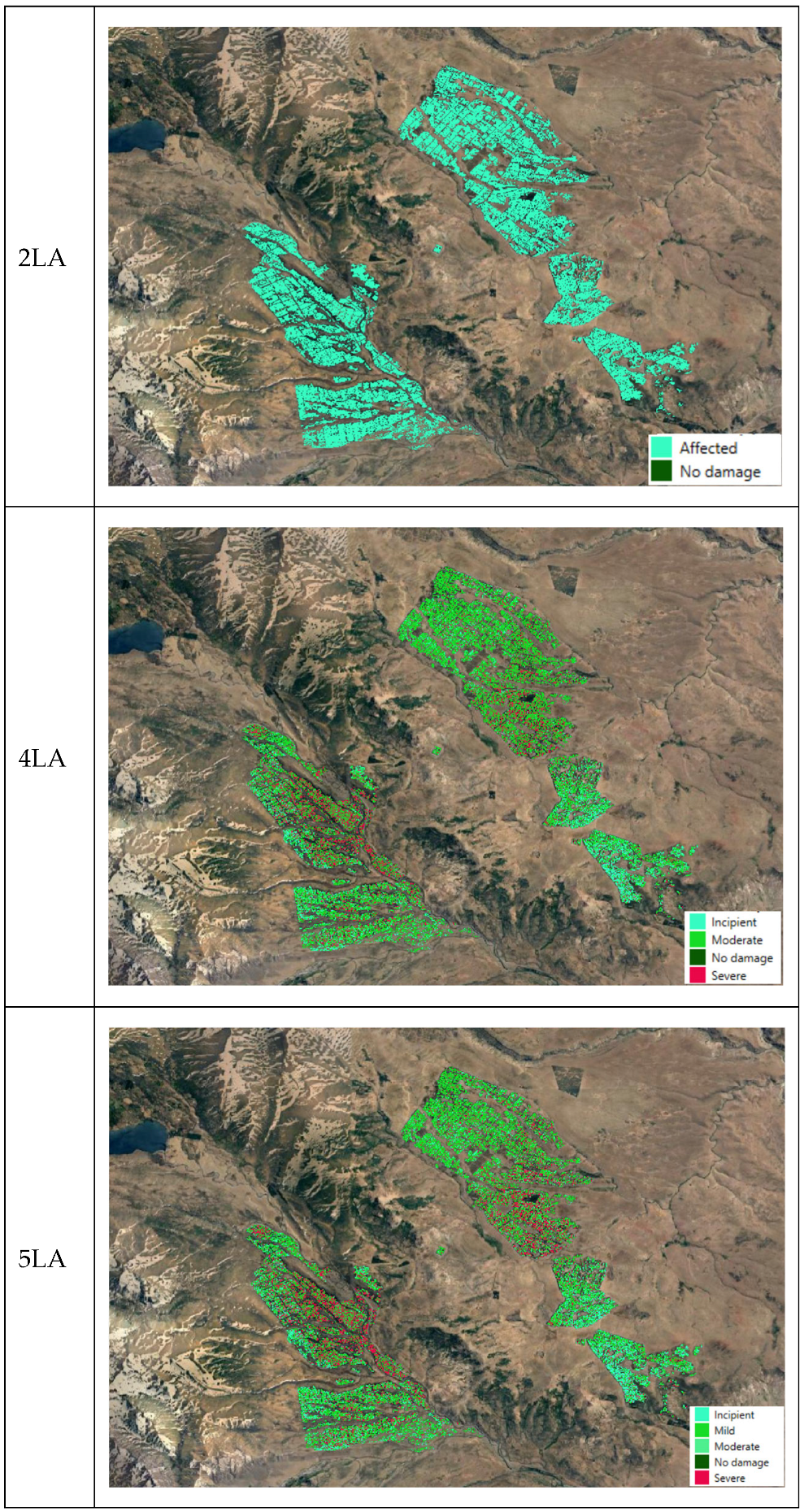
S. noctilio damage at both stand and large-area scales. The results indicate that the 2LA, focusing on no damage/affected tree detection, outperformed 5LA, 3LA, and 4LA, which aimed to classify specific Sirex damage categories. Our 2LA findings, consistent with the reserch of Gao et al. (2022) [
3] on the red turpentine beetle,
Dendroctonus valens, in Pinus trees, demonstrate the potential of SI’s to distinguish between early-infested and healthy trees (overal accuracy 89–98% and 84%, respectively).The RF model results obtained by [
13,
14] in their research of Sirex in South African pine plantations with three infection scales were comparable to our finding (2023 overall accuracy 79–81%). The high level of disagreement in 2019 between the 3LA, 4LA, and 5LA, as shown in the confusion matrices, highlights the challenges of accurately classifying pixels that belong to multiple classes, especially when considering spatial patterns in the observed and predicted data. Additionally, the model’s accuracy improved for 2023 data compared to 2019, suggesting better performance in detecting established infestations.
However, our study highlights the need for further refinement of the model to improve the classification of different damage severities. Time series analysis was found to be crucial in differentiating damage-related changes from natural variations [
35], and prediction at a regional scale can be realized by using long time series remote sensing data [
35]. Host water loss, although not always visually apparent, is a critical indicator of stress; remote sensing studies have revealed significant differences in spectral responses between canopy discoloration, characterized by chlorosis or reddening and insect-induced defoliation [
12].
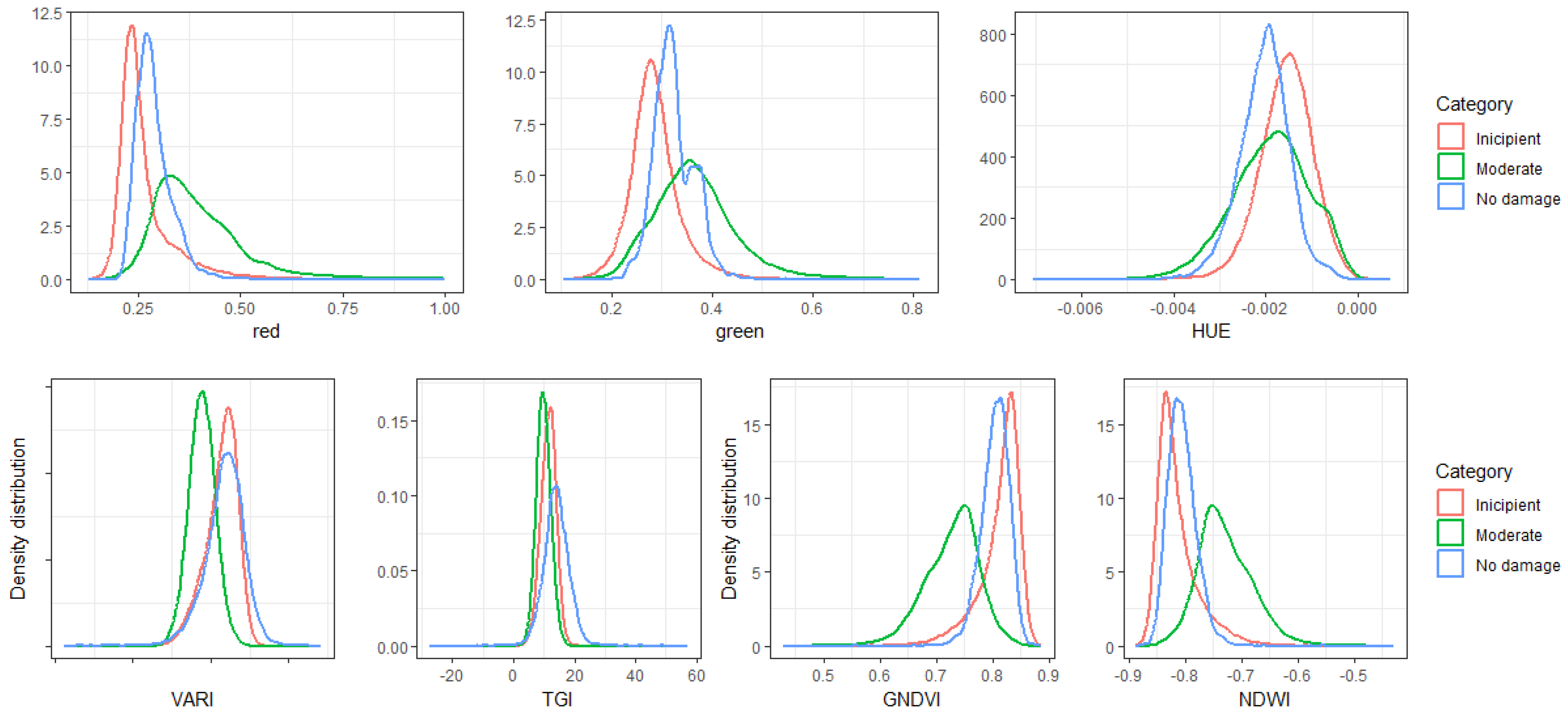
Our analysis revealed that specific spectral indices, such as VARI, GNDVI, TGI, and NDWI, were crucial for discriminating among the different
S. noctilio damage categories. These indices serve as vital indicators of vegetation health, allowing us to detect subtle changes that may precede visible symptoms on trees. Spectral indices demonstrated sensitivity to changes in tree mortality caused by
S. noctilio, capturing various aspects of plant stress and enabling a more comprehensive damage assessment. Despite the overall trends, the significant variability observed over time in index values can be attributed to fluctuations in
S. noctilio population dynamics, climatic factors, and other uncontrolled variables. Recently, Villaverde (2020) [
12] identified a significant relationship between Sirex infestation levels and various spectral indices within the same geographic region. By leveraging high-resolution satellite imagery from Landsat 8 and Sentinel-2, the study analyzed correlations between the Normalized Difference Vegetation Index (NDVI), Normalized Difference Water Index (NDWI), Modified Soil Index (MSI), and Soil-Adjusted Vegetation Index (SAVI) and the extent of insect-caused damage. According to Villaverde (2020) [
12], the combination of different spectral indices provides a more comprehensive and robust understanding of tree stand status, offering deeper insight into the mechanisms underlying Sirex-induced damage. In our study, indices such as GNDVI and HUE are useful for detecting early signs of Sirex damage before symptoms become visible in aerial imagery or field surveys. Additionally, indices like VARI, GNDVI, NIR, and NDWI have proven to be effective indicators of overall tree health, helping to identify areas at higher risk. The decline in VARI values in Sirex-affected areas highlights its utility for monitoring damage progression.
GNDVI, with its strong correlation to Sirex damage, is particularly sensitive to changes in chlorophyll content, making it a valuable tool for assessing vegetation health. While NDWI shows a less direct relationship with Sirex damage, it provides valuable insights into plant water content, helping to identify water stress. The TGI, initially developed to correlate with chlorophyll content at the canopy level, exhibits its highest sensitivity to changes in Leaf Area Index [
36]. This index’s strong correlation with chlorophyll content makes it a useful tool for detecting subtle variations in plant health directly related to green foliage losses caused by Sirex. According to Magalhães et al. (2024) [
36], as the canopy becomes denser, indices strongly associated with green reflectance, such as VARI and TGI, accurately separate categories with less damage from those with more damage. Finally, indices such as TGI, NIR, green, red, and HUE offer supplementary information on various aspects of Sirex-induced damage, including reduced biomass, changes in pigment composition, and alterations in leaf structure (additional details can be found in
Table 8).
In addition to identifying early signs of S. noctilio damage, our analysis also highlighted how these spectral indices fluctuated over time, reflecting the evolving dynamics of the infestation in pine plantations. Interestingly, we observed that the significance of these indices shifted between 2019 and 2023, likely reflecting changes in the dynamics of the Sirex population and its impact on tree mortality. As the infestation progressed, early signs of damage became increasingly pronounced, underscoring the growing impact of this invasive pest on plantation forest health. Furthermore, while the spectral indices of all damage categories exhibited similar temporal trends, indicating a generalized spectral response of vegetation to the infestation, inter-category variability was observed. Some damage categories showed higher or lower values in specific spectral bands, suggesting differential physiological responses to the Sirex infestation. By incorporating these temporal trends into our classification models, we achieved accurate mapping of damage levels across the study area, enabling visualization of the extent and severity of Sirex damage over time. This enhanced mapping capability is essential for guiding targeted pest management efforts, ensuring that interventions can be implemented promptly and effectively to mitigate further damage to forest resources.
Given that the accuracy and consistency of our approach largely depend on the field data used for training, future research should explore the integration of additional remote sensing data sources, such as hyperspectral imagery or LiDAR, which could provide greater spectral and structural detail to enhance the discrimination of subtle stress symptoms. In our study, we relied on training data obtained from aerial visual surveys of the damage categories generated by S. noctilio over large areas, which may introduce inherent biases. These biases can arise from subjective interpretations of Sirex damage levels, variations in visibility due to environmental conditions, and the limitations of aerial surveys in capturing fine-scale damage details. Additionally, classification results may be influenced by atmospheric conditions, sensor calibration, and variability in vegetation responses to stress factors. However, when evaluating the model’s performance in a new plantation affected by Sirex, where damage levels were quantified in smaller sampling units, its accuracy remained consistent. This suggests that our model can adapt to different assessment contexts and continues to be valuable for detecting Sirex tree mortality.


