Abstract
The rapid construction of expressways in China has brought significant economic and social benefits, but it has also imposed substantial ecological pressures, particularly in sensitive regions. Landscape ecological risk assessment, as an important means to predict and measure the adverse effects of human activities on the ecological environment, is being paid more and more attention. However, most studies focus on the static landscape mosaic pattern and lack dynamic analysis. Moreover, they mainly focus on the ecological effect of the road operation stage, ignoring the monitoring and analysis of the whole construction process. Based on this, the current study examines the landscape ecological risk and land use changes along the Linghua Expressway in Gansu Province using high-resolution GF-1 remote sensing imagery. A landscape ecological risk assessment (LERA) model was employed to quantify the land use changes and assess the ecological risks before and after the expressway construction between 2018 and 2022. The results revealed a decrease in cropland and forest land, accompanied by an increase in the grassland and road areas. The landscape ecological risk index decreased from 0.318 in 2018 to 0.174 in 2022, indicating an improvement in ecological resilience. However, high-risk zones remain near the expressway, emphasizing the need for continuous monitoring and proactive ecological management strategies. These findings contribute to sustainable infrastructure planning, particularly in ecologically sensitive regions.
1. Introduction
The construction of expressways in China is experiencing rapid development, becoming a critical component of the country’s infrastructure expansion [1,2]. While the establishment of transportation networks brings significant economic and social benefits, it simultaneously imposes substantial pressure on the surrounding natural ecosystems [3,4]. These impacts are particularly pronounced in ecologically sensitive regions where expressway construction disrupts habitat integrity and alters landscape structure, leading to biodiversity loss and ecosystem degradation [5,6]. The expansion of transportation networks often requires the clearance of large areas of natural habitats to accommodate road construction, creating a new boundary line that fragments habitat and disrupts ecological connectivity [7,8]. This, in turn, leads to habitat loss, increased road mortality, migration barriers, and changes in wildlife behavior and mobility patterns [9,10]. As human activities extend into previously undisturbed areas, the pressure on ecosystems intensifies, resulting in increased urbanization, deforestation, and land use changes that further degrade the environment [11,12]. Therefore, monitoring the ecological impacts of road construction, especially in regions of high biodiversity, is essential for maintaining ecosystem balance [13,14].
In recent years, the ecological impacts of transportation networks have become a key research focus globally [15,16]. Numerous countries are now prioritizing the integration of ecological considerations into road development, shifting from traditional small-scale assessments to broader landscape-scale studies [17,18,19]. Since the 1990s, research has increasingly emphasized the landscape level, assessing how road networks affect larger ecological processes, such as habitat fragmentation, species distribution, and landscape connectivity [20,21]. Despite these advances, significant challenges remain, particularly regarding data availability [22,23]. Many studies suffer from a lack of comprehensive datasets, which hinders the ability to evaluate the full spectrum of ecological impacts [24]. Furthermore, most of the existing research predominantly focuses on the ecological effects during the operational phase of highways, neglecting the critical insights that can be gained from monitoring the entire construction process [25]. This gap underscores the necessity of continuous assessment throughout all phases of highway development [26,27]. Remote sensing (RS) and geographic information systems (GIS) have emerged as powerful tools in addressing this gap by enabling the large-scale, continuous monitoring of landscape patterns and changes in land use [28,29]. The application of RS data, such as high-resolution GF-1 imagery, provides valuable insights into landscape dynamics, making it indispensable for evaluating the environmental impacts of infrastructure projects [30,31].
This study focuses on assessing the landscape ecological risk of the Linghua Expressway (Lingtai to Huating Expressway) in Pingliang City, Gansu Province, using GF-1 remote sensing imagery [32,33]. The region is known for its rich biodiversity and ecological resources [34,35], making it particularly sensitive to infrastructure development [36]. By employing a landscape ecological risk assessment (LERA) model, this study aims to quantify changes in land use and assess the spatial distribution of ecological risks along the expressway corridor [37,38]. Through the integration of RS data with the LERA framework, we aim to identify high-risk areas that require targeted conservation measures [39,40]. The results of this study will provide valuable insights for balancing infrastructure development with ecological conservation, contributing to the sustainable development of the region [41,42]. Additionally, the findings may serve as a reference for other infrastructure projects in ecologically sensitive areas, underscoring the importance of incorporating advanced monitoring techniques into environmental impact assessments [43,44].
2. Materials and Methods
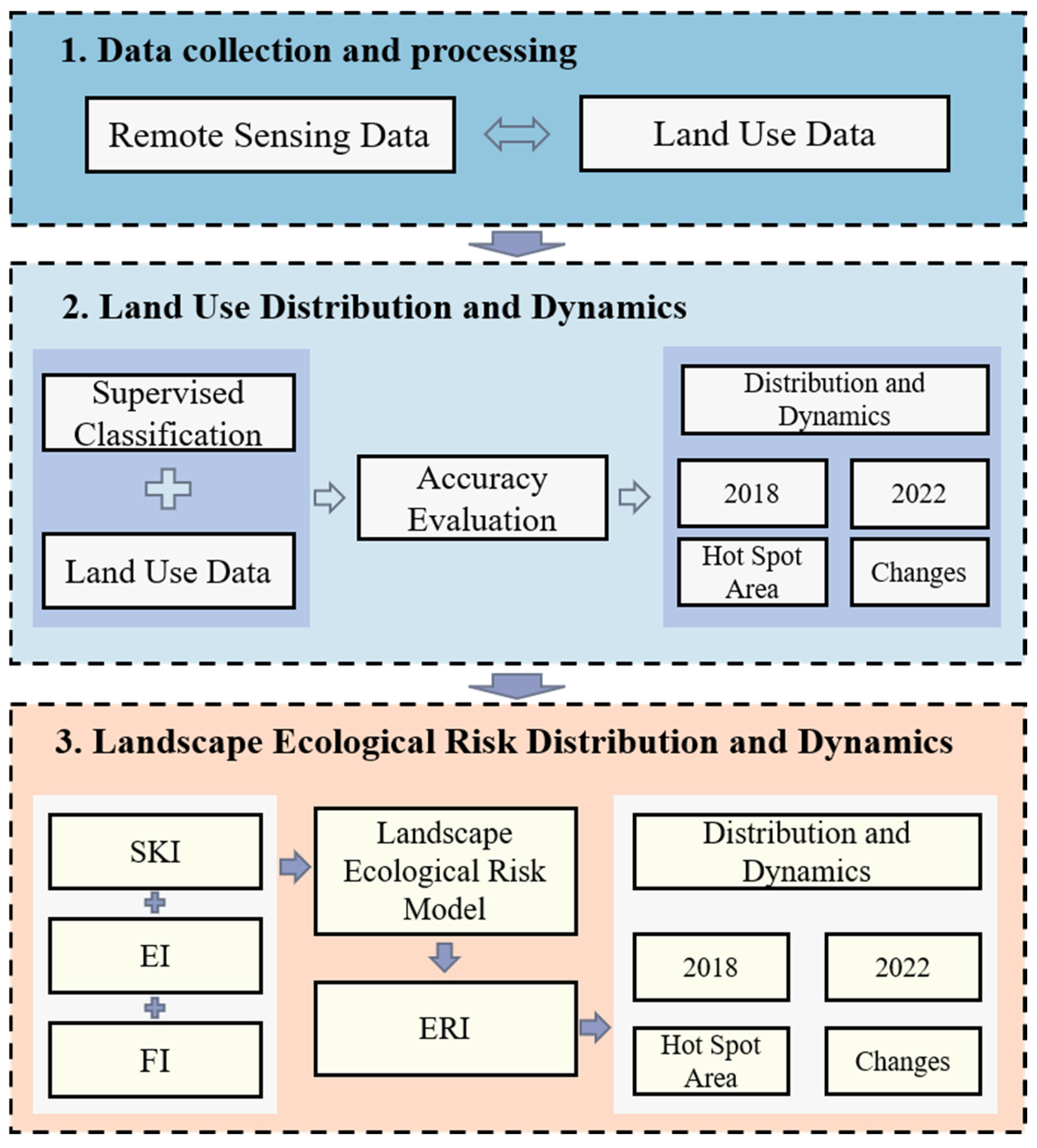
Based on supervised classification and the Landscape Ecological Risk Model, the land use changes and landscape ecological risks before and after the construction of Linghua Expressway were evaluated, and the potential impacts of road construction on the ecological environment were revealed. Figure 1 presents a schematic of the entire process.

Figure 1.
The flow chart of this study.
2.1. Research Area
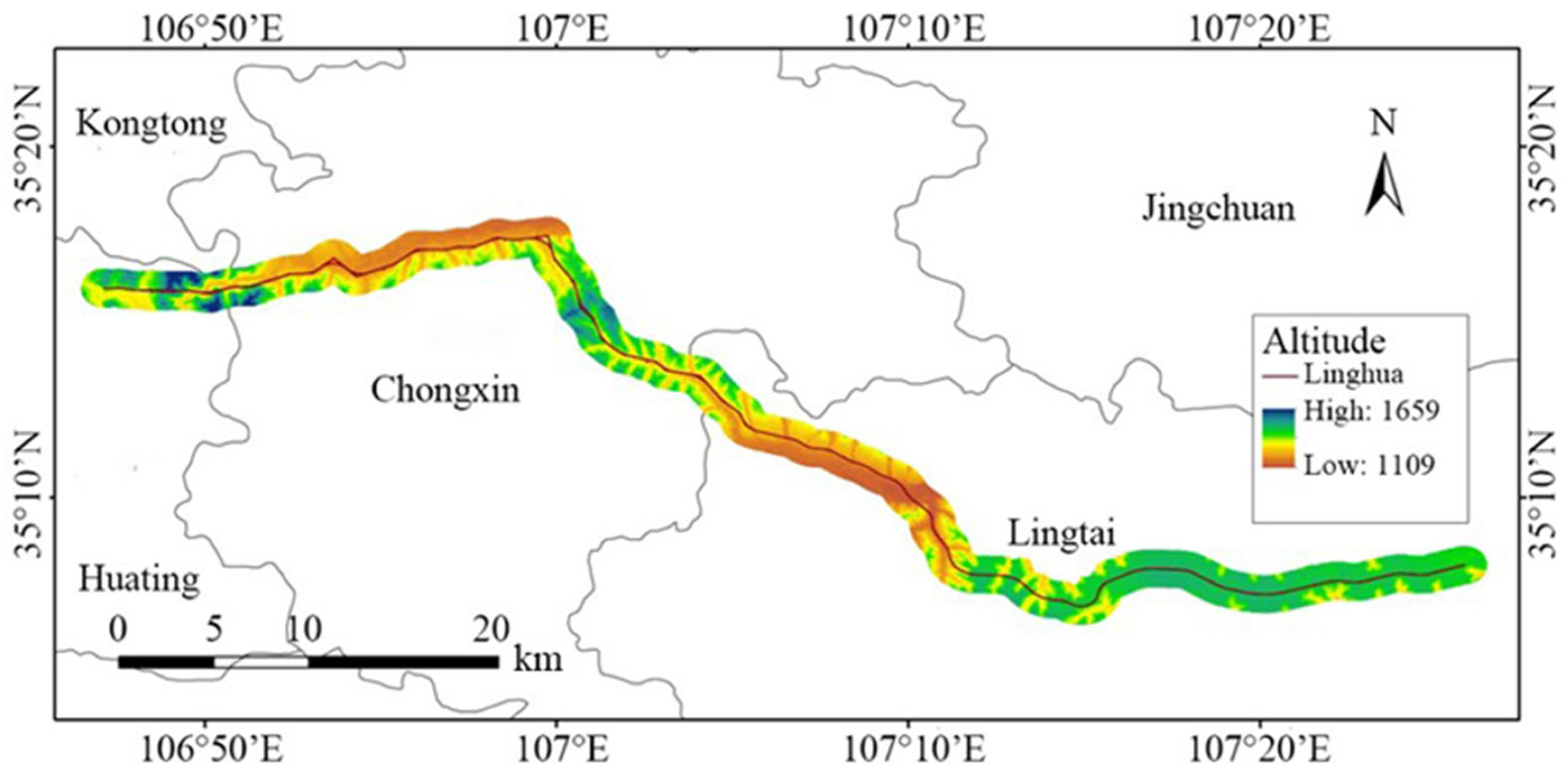
The Linghua Expressway, spanning 68 km, is situated in the Loess Plateau of eastern Gansu Province [45,46]. This area mainly belongs to the geological structural unit of North China, and the stratigraphy mainly includes Mesozoic and Cenozoic sedimentary rocks. This expressway predominantly follows the river valley, with approximately 5 km of tunnels located in the ecologically sensitive Yulongshan Provincial Forest Park at the border of Huating and Chongxin counties [47,48] (Figure 2). Construction on the first phase of the expressway commenced in November 2019, and it officially opened to traffic in December 2023 [49]. The region is characterized by a semi-arid to semi-humid continental climate, classified as a cold temperate semi-humid zone according to provincial standards [50]. The southern part of the area experiences wetter conditions, while the northern section is drier, with distinct temperature variations influenced by the complex topography and elevation changes across the landscape [51].
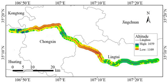
Figure 2.
Linghua Expressway main line and research area.
2.2. Data Sources and Preprocessing
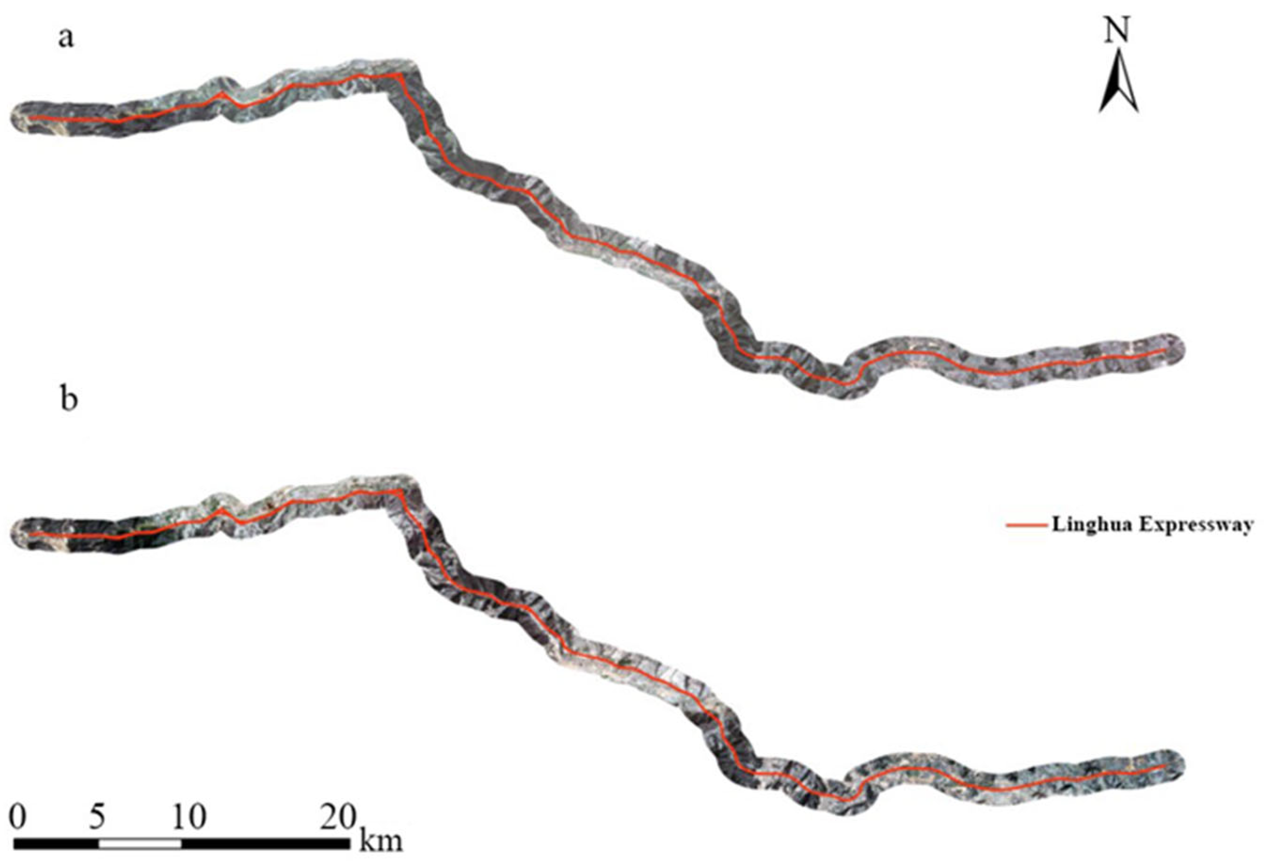
In this study, GF-1 remote sensing images from May to September of 2018 and 2022 were selected, as these months represent optimal vegetation growth periods with minimal cloud interference. Compared to Landsat and Sentinel-2 data, GF-1 images offer higher spatial resolution, better detail-capturing capabilities, and shorter revisit cycles, making them well-suited for accurate real-time dynamic monitoring [52,53]. The images underwent a rigorous preprocessing workflow, which included absolute radiometric calibration using coefficients from domestic land-based observation satellites [54,55]. Following this, atmospheric correction was applied to mitigate the effects of atmospheric scattering on image quality [56,57]. The preprocessed panchromatic and multispectral images were then fused, stitched, and cropped to generate the final remote sensing datasets for 2018 and 2022 [58,59], as illustrated in Figure 3.
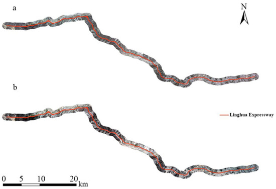
Figure 3.
Remote sensing images of the study area in 2018 (a) and 2022 (b).
The boundary of the Linghua Expressway was provided by the construction company, representing the primary route [60]. Additionally, 30 m spatial resolution digital elevation model (DEM) data were obtained from the Geospatial Data Cloud (https://www.gscloud.cn (accessed on 1 March 2022)), which were subsequently utilized to derive slope and aspect data through geospatial calculations [61,62].
2.3. Land Use Classification and Landscape Ecological Risk Model
Land use data were acquired through supervised classification of the GF-1 remote sensing images [63,64]. The classification system categorized land use into seven types: cropland, forest land, grassland, house construction, roads, unutilized land, and water bodies [65,66]. In ArcGIS Pro, over 100 sample points were selected for each land use type to ensure comprehensive representation of various forms and periods [67,68]. The resulting classification was manually interpreted and modified to produce the final raster data for land use interpretation [69,70].
Furthermore, a landscape ecological risk model was constructed based on the disturbance index (Ei) and the fragility index (Fi) [71,72]. The Ei reflects the landscape’s resistance to external disturbances, informed by landscape fragmentation, separation, and dominance [73,74] to which we assigned specific weights of 0.5, 0.3, and 0.2, respectively [75,76]. The Fi indicates the vulnerability of different ecosystems, where a higher value denotes greater susceptibility to disturbances [77,78]. Normalization was applied following value assignment [79]. The landscape ecological risk index (ERI) was calculated as follows:
In this formula, N represents the total number of landscape types within the sample area, Ski denotes the area of landscape type i, Sk is the total area of the sample area, Ei is the disturbance index for landscape type i, and Fi represents the vulnerability index for landscape type i [80,81].
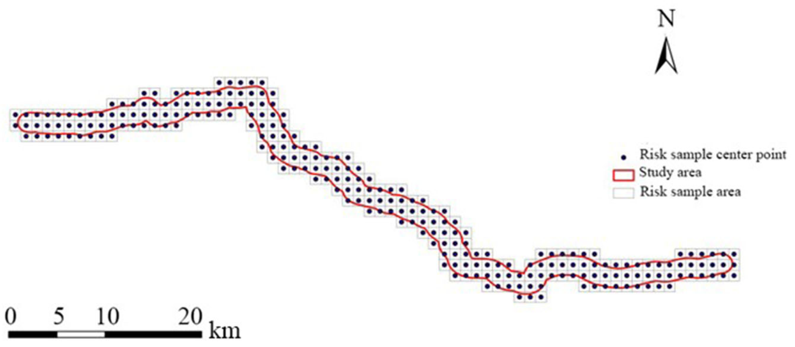
To facilitate landscape ecological risk calculations, the study area was divided into a 1 km by 1 km grid, with each grid cell serving as an independent research unit [82,83]. The research of landscape ecology shows that when the area of landscape samples is 2–5 times of the average patch area, it can better reflect the landscape information around the sampling area, and detailed spatial analysis of the ecological risk index within the buffer zone can be carried out [84,85]. Utilizing ArcGIS 10.8, a total of 246 sample areas were generated for comprehensive risk assessment [86,87] (Figure 4). According to the established landscape ecological risk model, the landscape ecological risk index was calculated for each sample area and assigned to the central point of the sample area. In order to display the spatial distribution characteristics of ecological risk in the study area more intuitively, the spatial distribution of landscape ecological risk index in the study area in 2018 and 2022 was obtained by using the common Kriging interpolation method.
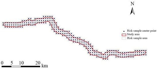
Figure 4.
Landscape ecological risk sample grid of the study area.
3. Results
3.1. Evaluation of the Accuracy in Land Use Classification
To assess the accuracy of the land use classification results, over 400 precision points were randomly selected, utilizing visual interpretation as the reference for true surface conditions. In the 2018 accuracy assessment, the overall classification accuracy for the road area reached 82.73%, with a kappa coefficient of 0.80. These results indicate a satisfactory classification performance consistent with local conditions. Among the various land use types, cropland, forest land, and water bodies exhibited the highest accuracies of 97.30%, 94.59%, and 97.22%, respectively. Conversely, the grassland and road classifications yielded accuracies of 76.92% and 70.97%. Notably, housing construction showed the lowest accuracy at 53.85%, suggesting challenges in distinguishing this land use type. In the accuracy evaluation for 2022, the overall classification accuracy slightly declined to 82.04%, accompanied by a kappa coefficient of 0.79. Despite the decrease, the results remained adequate for subsequent remote sensing analyses. Once again, cropland, forest land, and water bodies maintained high classification accuracies of 97.18%, 94.37%, and 97.18%, respectively. Grassland and road accuracies improved slightly to 78% and 70%, while unutilized land recorded an accuracy of 64.86%. The persistent low accuracy for housing construction underscores the need for enhanced classification methodologies in future studies. These accuracy evaluations confirm the reliability of the land use classification results, which are crucial for understanding the dynamics of land use in the context of the Linghua Expressway construction. The high accuracies for cropland and forest land highlight their significance in the regional landscape, while the lower accuracies for housing construction and roads indicate areas for methodological improvement.
3.2. Analysis of Land Use Changes
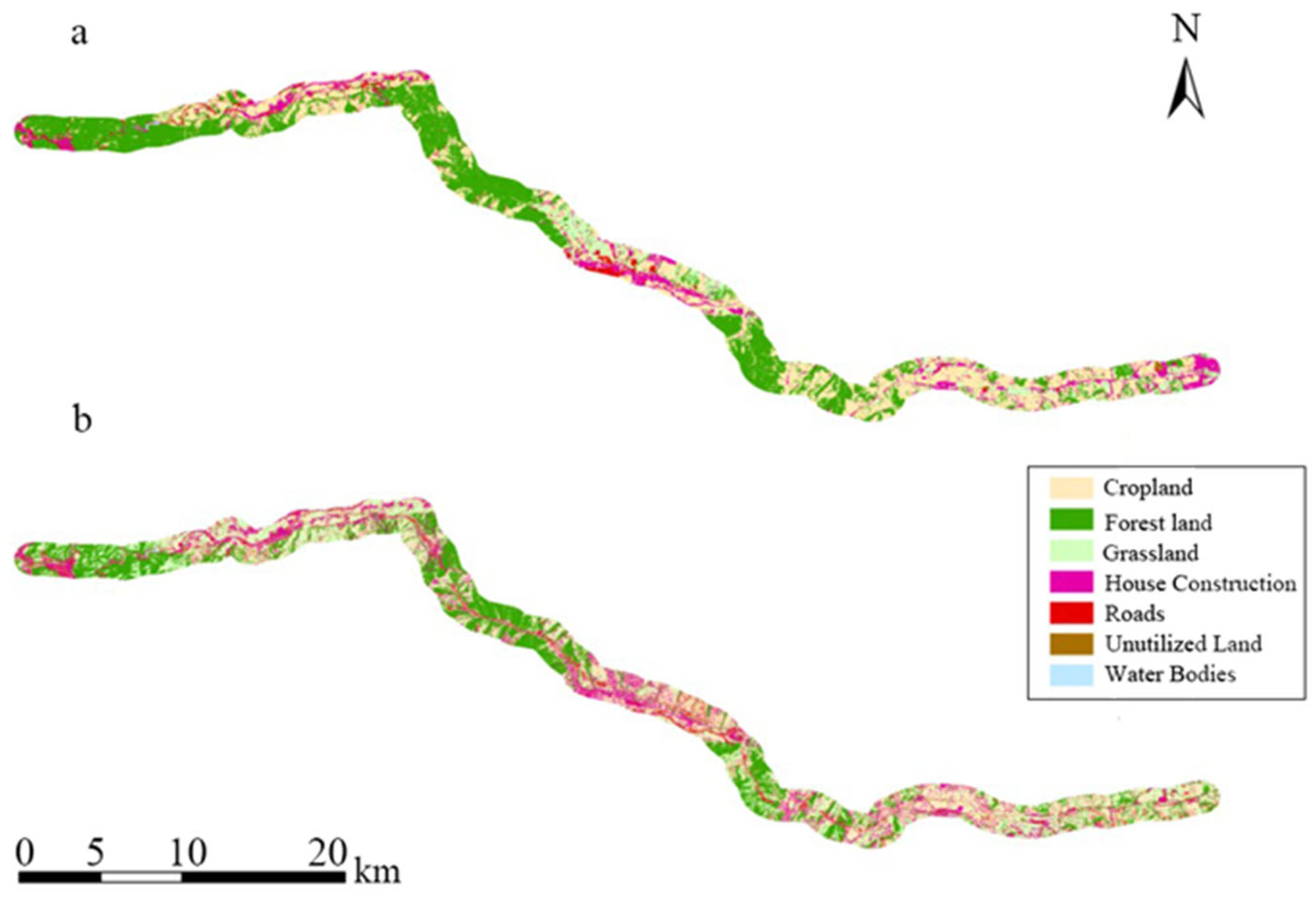
Land use interpretation was conducted based on seven categories: cropland, forest land, grassland, housing construction, road, unutilized land, and water bodies, as shown in Figure 5a,b. By 2022, significant changes in land use distribution occurred within the 1 km buffer zone surrounding the Linghua Expressway compared to 2018. The construction of the expressway resulted in noticeable fragmentation of the landscape, particularly evident in the bisected areas of forest land and grassland.
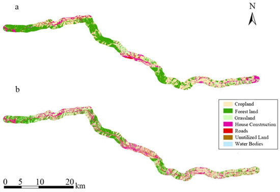
Figure 5.
Land use classification maps of the study area in 2018 (a) and 2022 (b).
In the western region, characterized by cropland and residential areas, the landscape appeared more fragmented, although the road construction did not drastically alter the overall land use patterns. Throughout both 2018 and 2022, cropland and forest land remained the predominant land use types, suggesting that the construction of the Linghua Expressway did not significantly disrupt established land use dynamics (Table 1). In 2018, cropland and forest land were the primary land use types, with cropland covering 52.87 km2 (36.6% of the total area) and forest land encompassing 48.77 km2 (33.8%). Together, these types represented over 70% of the total area. Water bodies were minimal, comprising only 0.21 km2 (0.1% of the total area). By 2022, the cropland area decreased to 44.36 km2 (30.7%), and forest land reduced to 40.14 km2 (27.8%), indicating slight declines of 8.51 km2 and 8.63 km2, respectively. In contrast, the grassland area increased from 22.01 km2 in 2018 to 30.17 km2 in 2022, marking an increase of 8.16 km². The housing construction area expanded to 18.08 km2, a rise of 2.87 km2 from 2018, while road areas increased by 5.07 km2, from 4.84 km2 in 2018 to 9.91 km2 in 2022. Water bodies exhibited minimal change, with an increase of only 0.13 km2.

Table 1.
Area and percentage of each land use type in the study area, 2018 and 2022.
3.3. Landscape Ecological Risk Distribution
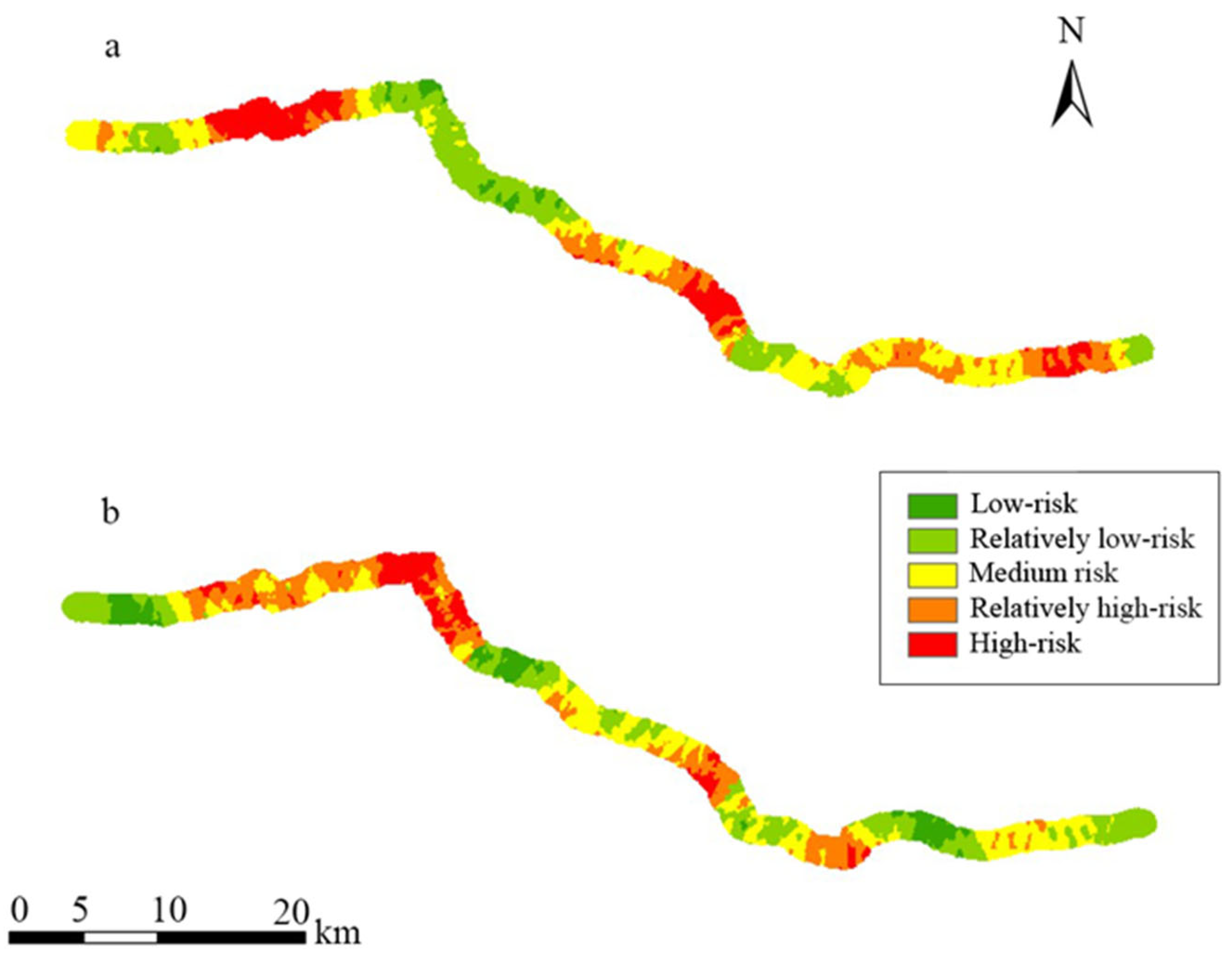
Using the established landscape ecological risk model, we calculated the landscape ecological risk index for each sample area, assigning it to the central point of the sample area. The Kriging interpolation method was employed to visually represent the spatial distribution of ecological risk, as illustrated in Figure 6. In 2018, the average landscape ecological risk value was 0.32, with high-risk areas concentrated in the central-western region. Partially high-risk zones were identified in the central and eastern regions, including segments of Chongxin County and Lingtai County. By 2022, the average risk value decreased to 0.17, with previously high-risk areas in the west downgraded to relatively high-risk status. Conversely, the ecological risk in the central and western regions increased, while the overall risk in the eastern region showed a decline. The spatial distribution in 2022 revealed a trend of decreasing risk levels moving outward from the main road corridor, indicating that road construction exerts considerable risks on surrounding landscape patches, particularly those closer to the roadway.

Figure 6.
Spatial distribution of landscape ecological risk of the study area in 2018 (a) and 2022 (b).
3.4. Landscape Ecological Risk Dynamics
The calculated proportions of landscape ecological risks before and during the construction of the Linghua Expressway (Figure 7) demonstrate that prior to construction, the majority of the area fell within the medium-risk category at 29.45%, followed by 28.35% in the relatively low-risk category, 21.59% in the relatively high-risk category, and 17.92% in the high-risk category. The low-risk category accounted for only 2.69%. This distribution indicates that the overall landscape ecological risk level in the study area was predominantly medium to high. With the construction of the Linghua Expressway, the proportion of low-risk areas increased to 9.85%, while relatively high-risk areas rose by 3.59% to 25.18%. In contrast, the proportions of relatively low-risk and medium-risk areas decreased by 2.12% and 1.4%, respectively, while high-risk areas decreased by 7.23%. Although the overall landscape ecological risk has decreased, the region remains predominantly characterized by relatively low-, medium-, and relatively high-risk levels. The reduction in high-risk areas and the increase in low-risk areas can be partially attributed to the expansion of construction land. However, the Linghua Expressway’s construction has also elevated the landscape ecological risks in surrounding areas, with minimal changes in the proportions of other risk categories.
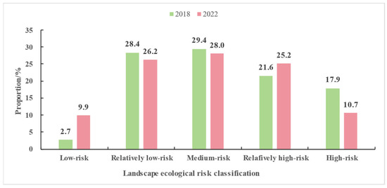
Figure 7.
Landscape ecological risk classification area proportion.
4. Discussions
4.1. Evaluation of the Accuracy in Land Use Classification
The evaluation of land use classification accuracy revealed overall classification accuracies of 82.73% in 2018 and 82.04% in 2022 [88,89], indicating that the supervised classification approach employed is both reliable and efficient for large-scale remote sensing applications [90,91]. The high accuracies for cropland, forest land, and water bodies demonstrate their distinctive spectral characteristics, which facilitate accurate differentiation [92,93]. However, the comparatively lower accuracies for house construction, particularly at 53.85% in both years, underscore the complexities involved in classifying urban land types [94]. The building forms are diverse, with varying sizes and colors. The distance between them is relatively close, and artificial gardens and grass are intermingled in the middle, which is prone to cause misjudgment. It is necessary to adopt higher-resolution remote sensing data and combine manual visual interpretation with computer automatic classification to further enhance the classification accuracy [95,96]. The consistency of classification results across the study years also reflects the stability of land use patterns, thereby confirming the effectiveness of the chosen classification strategy [97,98].
4.2. Analysis of Land Use Changes
The analysis of land use changes highlights significant ecological transformations along the Linghua Expressway, driven primarily by infrastructure development [99,100]. The decline in cropland and forest land, alongside the increase in grassland, raises concerns about potential biodiversity loss and ecosystem degradation [101,102]. The conversion of forest land to grassland, in particular, indicates a shift towards less stable ecosystems [103,104], which can have cascading effects on local hydrology and soil health [105]. This alteration not only diminishes the area’s ecological integrity but also exacerbates issues such as reduction in water retention capacity and soil erosion, critical factors in maintaining environmental sustainability [106,107]. Furthermore, the fragmentation observed in land distribution underscores the impact of the expressway on ecological connectivity, leading to isolated habitats that can hinder wildlife movement and reduce genetic diversity [108,109].
4.3. Landscape Ecological Risk Distribution
The calculated landscape ecological risk index decreased from 0.318 in 2018 to 0.174 in 2022 [110,111], suggesting a relative improvement in the ecological resilience of the area. However, the persistence of high-risk zones, particularly near the expressway, indicates that while some areas may have benefited from construction, significant ecological vulnerabilities remain [112]. High-risk areas were identified, especially in regions such as Hengqu Village to Lingtai County, underscoring the need for continuous ecological monitoring [113,114]. These findings align with previous studies, which emphasize that infrastructure projects often increase ecological vulnerability in sensitive areas due to habitat fragmentation and land use conversion [115,116]. However, most previous studies focused on the ecological effects in the road operation stage and paid little attention to the impact of pre-construction work on the ecological environment. Damage to vegetation and the environment in the early stages of construction is often the key reason for the intensification of ecological risks. This study assessed the ecological risks before and after road construction and provides a more comprehensive view of the impact of road construction on the environment. The spatial distribution of risk, as indicated by the Kriging interpolation method, reveals the significant ecological effects of road construction, with the most impacted areas being those adjacent to the expressway [117]. In 2018, high-risk areas were mainly concentrated around house construction, where human activities were intense. The risk gradually decreased as the distance from the house construction Increased, and the landscape ecological risk of forest land and grassland was the lowest. In 2022, the distribution of high-risk areas changed significantly, mainly in areas where forest land degradation occurred due to road construction. Although the forest land has not completely vanished and only part of it has been degraded to grassland, its landscape ecological risk is much higher than that of housing construction areas. It can be observed that forest land is of great significance for maintaining the stability of the ecosystem, and the damage caused to the ecosystem by road construction is severe.
4.4. Landscape Ecological Risk Dynamics
The dynamics of landscape ecological risk reveal a complex interplay between infrastructure development and ecological health [118,119]. While the overall landscape ecological risk index shows a decrease in high-risk areas, the region remains predominantly characterized by medium- to relatively high-risk levels [120]. This suggests that although the construction of the Linghua Expressway contributed to some reduction in ecological risks, it also elevated risks in the surrounding areas, particularly those closer to the road [121,122]. The shift from high-risk to medium- and low-risk categories in some areas reflects the stabilization of the construction land [123,124], which typically has a stronger ability to resist ecological disturbances [125]. However, the ecological risks associated with the ongoing human activities, including urbanization and increased land use, cannot be overlooked [126,127]. Proactive measures, such as habitat restoration and continuous ecological assessments, are essential during and after the construction phases to mitigate long-term impacts on the landscape [128]. In addition, the study also found that species richness as a driving factor has a certain degree of impact on landscape ecological risk. Therefore, restoring high-risk areas and ensuring the maintenance of biodiversity and ecosystem functions will be critical to the sustainable development of the region [129,130]. The research results can provide a theoretical basis for the government to realize the sustainability of road construction and the maintenance of the regional ecological environment and reduce the ecological risk brought by road construction.
4.5. Limitations and Recommendations for Future Research
Through comparative analysis of land use and landscape ecological risk changes before and after the construction of the Linghua Expressway, this study effectively reflects the impact of road construction on the ecological environment, but there are still two limitations. First, the research focuses on the landscape ecological risk at the ecosystem level, and the ecological sensitivity is not adequately reflected. Second, the study reflects the impact of Linghua Expressway construction on the ecological environment. Whether the construction of other roads in different ecological environments has the same impact remains to be verified. In future studies, the research scope can be extended to other ecosystem functions and structures, such as ecological sensitivity, watershed connectivity, habitat connectivity, and the number of typical species, so as to increase the number of studies on the impact of road construction under different environmental backgrounds and further reflect the impact of road construction on ecosystems.
5. Conclusions
This study assesses the ecological impacts of the Linghua Expressway construction using remote sensing data, with land use classification accuracies of 82.73% in 2018 and 82.04% in 2022. Cropland, forest land, and water bodies were classified with the highest accuracy, providing reliable insights for subsequent ecological analyses. Between 2018 and 2022, cropland and forest land remained the dominant land use type, but there was a major shift in land use, with large areas of forest land and cropland converted into grasslands and roads due to the expressway’s construction. The landscape ecological risk index decreased from 0.318 in 2018 to 0.174 in 2022, reflecting an overall improvement in the area’s ecological resilience. However, the increase in ecological risk in the central and western regions and the gradually decreasing risk level from the main road corridor outward indicate that road construction has caused a greater risk to the surrounding landscape patches; high-risk areas near the expressway remain, highlighting the need for ongoing ecological monitoring and management. While the risk in high-risk areas declined, the increase in relatively high-risk areas close to the road underscores the importance of proactive measures such as habitat restoration. These findings emphasize the critical need to integrate ecological considerations into infrastructure projects to balance development with environmental protection and ensure the region’s long-term sustainability.
Author Contributions
Conceptualization, M.W. and H.W.; methodology, H.W.; formal analysis, M.W.; investigation, L.Z.; data curation, P.S., L.L., Z.Z. (Zixin Zha), and Z.Z. (Zhiru Zhang); writing—original draft preparation, M.W. and L.Z.; writing—review and editing, J.W.; supervision, J.W. and H.W.; funding acquisition, H.W. All authors have read and agreed to the published version of the manuscript.
Funding
This research was funded by the National Key Research and Development Program of China, grant number 2021YFB2600101.
Data Availability Statement
Data sharing is not applicable to this article.
Conflicts of Interest
The authors declare no conflicts of interest.
References
- Zhang, Y.; Wang, X. Infrastructure and ecological effects: An analysis of expressway construction in China. J. Environ. Manag. 2020, 256, 109909. [Google Scholar]
- Ochs, A.E.; Swihart, R.K.; Saunders, M.R. A comprehensive review of the effects of roads on salamanders. Landsc. Ecol. 2024, 39, 77. [Google Scholar] [CrossRef]
- Cheng, S.; Wei, Y.; Dai, Z.; Xu, W.; Wang, X.; Duan, J.; Zou, L.; Zhao, G.; Ren, X.; Feng, Y. Landscape ecological risk assessment and its driving factors in the Weihe River basin, China. J. Arid Land 2024, 16, 603–614. [Google Scholar] [CrossRef]
- Hou, J.; Yu, Y. Discourse on scientific advancements in mining ecological restoration. Min. Saf. Environ. Prot. 2023, 50, 15. [Google Scholar]
- Wu, J.; Liang, S. Assessing Terrestrial Ecosystem Resilience using Satellite Leaf Area Index. Remote Sens. 2020, 12, 4. [Google Scholar] [CrossRef]
- Zhang, S.; Jiang, H.; Yu, H.; Jiang, H.; Yu, H.; Feng, X.; Fan, M. Construction of landscape ecological network based on MCR risk assessment Model: A case study of Liaoning Province, China. Ecol. Indic. 2024, 166, 112549. [Google Scholar] [CrossRef]
- Ye, S.; Zhang, J.; Pan, L.; Yang, X.; Yu, Y. Ecological Environmental Cost Accounting of Mining Area Based on the Green Mine: A Case from a Mining Area in the North China Plain. Met. Mine 2019, 4, 168–174. [Google Scholar]
- Hlatshwayo, T.I.; Zungu, M.M.; Collinson-Jonker, W.J.; Downs, C.T. Mainstreaming ecological connectivity and wildlife needs in green road transport infrastructure planning in South Africa. J. Environ. Manag. 2024, 371, 123062. [Google Scholar] [CrossRef]
- Fahrig, L.; Merriam, G. Habitat patch connectivity and population survival. Ecology 1985, 66, 1762–1768. [Google Scholar] [CrossRef]
- Pimm, S.L.; Russell, G.J.; Gittleman, J.L.; Brooks, T.M. The future of biodiversity. Science 1995, 269, 347–350. [Google Scholar] [CrossRef]
- Ortega, Y.K.; Capen, D.E. Roads as edges: Effects on birds in forested landscapes. For. Sci. 2002, 48, 381–390. [Google Scholar] [CrossRef]
- Zhang, H.; Zhang, L.; Ma, X.; Zhang, Q. The declining trend of landscape ecological risk in Inner Mongolia over the past 30 years. Hum. Ecol. Risk Assess. 2024, 30, 680. [Google Scholar] [CrossRef]
- Boori, M.S.; Choudhary, K.; Kupriyanov, A. Integrating landscape ecological risk with ecosystem services in the Republic of Tatarstan, Russia. Comput. Opt. 2024, 48, 282–293. [Google Scholar] [CrossRef]
- Wu, J.; Zhang, L.; Zhao, B.; Yang, N.; Gao, P. Remote sensing assessing of vegetation and its resilience based on critical slowing down model and CLASSLAI: A case study in the Three Gorges Reservoir Area. Acta Ecol. Sin. 2023, 43, 5084–5095. [Google Scholar]
- Chen, L.; Tajchman, K.; Michalik-Sniezek, M.; Hanzal, V. Landscape fragmentation and biodiversity conservation: A case study of expressways. Ecol. Indic. 2013, 34, 147–154. [Google Scholar]
- Newmark, W.D. Insularization of the African rainforest: A case study of the effects of roads on wildlife in Tanzania. Biodivers. Conserv. 1995, 4, 327–343. [Google Scholar]
- Fukasawa, Y. Ecological impacts of fungal wood decay types: A review of current knowledge and future research directions. Ecol. Res. 2021, 36, 910–931. [Google Scholar] [CrossRef]
- Frantz, C.; Vienne, D. Habitat fragmentation and ecological consequences. Ecol. Model. 2008, 215, 35–48. [Google Scholar]
- Garre, S.; Meeus, S.; Gulinck, H. The dual role of roads in the visual landscape: A case-study in the area around Mechelen (Belgium). Landsc. Urban Plan. 2009, 92, 125–135. [Google Scholar] [CrossRef]
- Veryard, R.; Wu, J.; O’Brien, M.J.; Anthony, R.; Both, S.; Burslem, D.F.R.P.; Chen, B.; Cagigal, E.F.M.; Godfray, H.C.J.; Godoong, E.; et al. Positive effects of tree diversity on tropical forest restoration in a field-scale experiment. Sci. Adv. 2023, 9, 37. [Google Scholar] [CrossRef]
- Wu, J.; Liang, S. Developing an Integrated Remote Sensing Based Biodiversity Index for Predicting Animal Species Richness. Remote Sens. 2018, 10, 739. [Google Scholar] [CrossRef]
- Anderson, K.; Gaston, K.J. Lightweight and fast remote sensing data for biodiversity assessments. Ecol. Lett. 2013, 16, 1340–1347. [Google Scholar]
- Eddy, I.; Gergel, S.; Coops, N.; Henebry, G.; Levine, J.; Zerriffi, H.; Shibkove, E. Integrating remote sensing and local ecological knowledge to monitor rangeland dynamics. Ecol. Indic. 2017, 82, 106–116. [Google Scholar] [CrossRef]
- Ji, Y.; Bai, Z.; Hui, J. Landscape Ecological Risk Assessment Based on LUCC-A Case Study of Chaoyang County, China. Forests. 2021, 12, 1157. [Google Scholar] [CrossRef]
- Morelli, F. Neglected effects of transport corridors: Attractiveness to wildlife and role in conservation planning. Anim. Conserv. 2017, 20, 401–402. [Google Scholar] [CrossRef]
- Gulci, S.; Akay, A.E. Assessment of ecological passages along road networks within the Mediterranean forest using GIS-based multi criteria evaluation approach. Environ. Monit. Assessment. 2015, 187, 779. [Google Scholar] [CrossRef]
- Wilcove, D.S.; Chen, L. Management of fragmented habitats: A review of the effectiveness of wildlife corridors. Conserv. Biol. 1998, 12, 1228–1238. [Google Scholar]
- Xie, J.; Coulthard, T.J.; Wang, M.; Wu, J. Tracing seismic landslide-derived sediment dynamics in response to climate change. Catena 2022, 217. [Google Scholar] [CrossRef]
- Wu, J.; Chen, B.; Reynolds, G.; Xie, J.; Liang, S.; O’Brien, M.J.; Hector, A. Monitoring tropical forest degradation and restoration with satellite remote sensing: A test using Sabah Biodiversity Experiment. Trop. Ecosyst. 21st Century 2020, 62, 117–146. [Google Scholar]
- Forman, R.T.T.; Sperling, D. Road Ecology: Science and Solutions; Island Press: Washington, DC, USA, 2002. [Google Scholar]
- Trombulak, S.C.; Frissell, C.A. Review of ecological effects of roads on terrestrial and aquatic communities. Conserv. Biol. 2000, 14, 18–30. [Google Scholar] [CrossRef]
- Bennett, A.F. Linking Landscapes and Ecology: The Role of Corridors and Connectivity; Island Press: Washington, DC, USA, 1999. [Google Scholar]
- Haddad, N.M.; Brudvig, L.A.; Clobert, J.; Davies, K.F.; Gonzalez, A.; Holt, R.D.; Lovejoy, T.E.; Sexton, J.O.; Austin, M.P.; Collins, C.D.; et al. Habitat fragmentation and its lasting impact on Earth’s ecosystems. Sci. Adv. 2015, 1, e1500052. [Google Scholar] [CrossRef]
- Fahrig, L. Effects of habitat fragmentation on biodiversity. Annu. Rev. Ecol. Evol. Syst. 2003, 34, 487–515. [Google Scholar] [CrossRef]
- Qiao, Q.; Zhen, Z.; Liu, L.; Luo, P. The Construction of Ecological Security Pattern under Rapid Urbanization in the Loess Plateau: A Case Study of Taiyuan City. Remote Sens. 2023, 15, 1523. [Google Scholar] [CrossRef]
- Kang, J.; Yang, J.; Qing, Y.; Lu, W. Landscape Ecological Risk Assessment of Saihanba under the Change in Forest Landscape Pattern. Forsets 2024, 15, 700. [Google Scholar] [CrossRef]
- Li, Q.; Ma, B.; Zhao, L.; Mao, Z.; Liu, X. Study on Spatial and Temporal Changes in Landscape Ecological Risks and Indicator Weights: A Case Study of the Bailong River Basin. Sustainability 2024, 16, 1915. [Google Scholar] [CrossRef]
- Yang, F.; Tang, Y.; Xiong, S.; Gu, C.; Xiao, Y. Development of Highway Construction Route Selection Based on Ecological Sensitivity Evaluation and Intervention Optimization Strategy Research. Land 2024, 13, 1850. [Google Scholar] [CrossRef]
- Beebee, T.J.C. Effects of Road Mortality and Mitigation Measures on Amphibian Populations. Conserv. Biol. 2013, 27, 657–668. [Google Scholar] [CrossRef]
- Zhu, L.; Yu, X. Ecological impacts of highways in China’s biodiversity hotspots. Biodivers. Sci. 2020, 28, 1105–1112. [Google Scholar]
- Gao, J.; Zhang, M.; Hu, Z.; Shan, W. Influence of expressway construction on the ecological environment and the corresponding treatment measures: A case study of Changyu (Changchun-Fuyu Lalin River) expressway, China. Nat. Environ. Pollut. Technol. 2020, 19, 1195–1201. [Google Scholar]
- Phillips, P.; Clark, M.M.; Baral, S.; Koen, E.L.; Bowman, J. Comparison of methods for estimating omnidirectional landscape connectivity. Landsc. Ecology. 2021, 36, 1647–1661. [Google Scholar] [CrossRef]
- Zhong, A.; Wang, Z.; Zhang, Z.; Hu, C. Remote sensing monitoring of ecological environment quality in mining areas under the perspective of ecological engineering. Environ. Earth Sci. 2024, 83, 1–18. [Google Scholar] [CrossRef]
- Lee, T.; Quinn, M.S.; Duke, D. Citizen, science, highways, and wildlife: Using a web-based GIS to engage citizens in collecting wildlife information. Ecol. Soc. 2006, 11, 1. [Google Scholar] [CrossRef]
- Liu, S.L.; Cui, B.S.; Dong, S.K.; Yang, Z.F.; Yang, M.; Holt, K. Evaluating the influence of road networks on landscape and regional ecological risk—A case study in Lancang River Valley of Southwest China. Ecol. Eng. 2008, 34, 91–99. [Google Scholar] [CrossRef]
- Abdullah, S.A.; Hezri, A.A. From Forest Landscape to Agricultural Landscape in the Developing Tropical Country of Malaysia: Pattern, Process, and Their Significance on Policy. Environ. Manag. 2008, 42, 907–917. [Google Scholar] [CrossRef]
- Mo, W.; Wang, Y.; Zhang, Y.; Zhuang, D. Impacts of road network expansion on landscape ecological risk in a megacity, China: A case study of Beijing. Sci. Total Environ. 2017, 574, 1000–1011. [Google Scholar] [CrossRef]
- Foley, J.A.; DeFries, R.; Asner, G.; Barford, C.; Bonan, G.; Carpenter, S.; Chapin, F.; Coe, M.T.; Daily, G.C.; Gibbs, H.; et al. Global consequences of land use. Science 2005, 309, 570–574. [Google Scholar] [CrossRef] [PubMed]
- Yang, H.; Wang, Z.; Dai, Q. Ecological impact assessment method of highways in Tibetan Plateau: A Case study of Gonghe-Yushu Expressway. J. Mt. Sci. 2020, 17, 1916–1930. [Google Scholar] [CrossRef]
- Tscharntke, T.; Klein, A.M.; Kruess, A.; Steffan-Dewenter, I.; Thies, C. Landscape perspectives on agricultural intensification and biodiversity—Ecosystem service management. Ecol. Lett. 2005, 8, 857–874. [Google Scholar] [CrossRef]
- Wang, X.; Blanchet, F.G.; Koper, N. Measuring habitat fragmentation: An evaluation of landscape pattern metrics. Methods Ecol. Evol. 2014, 5, 634–646. [Google Scholar] [CrossRef]
- Forman, R.T.T.; Deblinger, R.D. The ecological road-effect zone of a Massachusetts (U.S.A.) suburban highway. Conserv. Biol. 2000, 14, 36–46. [Google Scholar] [CrossRef]
- Schiesari, L.; Grillitsch, B. Pesticides meet megadiversity in the expansion of biofuel crops. Front. Ecol. Environ. 2011, 9, 215–221. [Google Scholar] [CrossRef]
- Haddad, N.M. Corridor use predicted from behaviors at habitat boundaries. Am. Nat. 1999, 153, 215–227. [Google Scholar] [CrossRef]
- Fischer, J.; Lindenmayer, D.B. Landscape modification and habitat fragmentation: A synthesis. Glob. Ecol. Biogeogr. 2007, 16, 265–280. [Google Scholar] [CrossRef]
- Saunders, D.A.; Hobbs, R.J.; Margules, C.R. Biological consequences of ecosystem fragmentation: A review. Conserv. Biol. 1991, 5, 18–32. [Google Scholar] [CrossRef]
- Haddad, N.M.; Bowne, D.R.; Cunningham, A.; Danielson, B.J.; Levey, D.J.; Sargent, S.; Spira, T. Corridor use by diverse taxa. Ecology 2003, 84, 609–615. [Google Scholar] [CrossRef]
- Hanski, I.; Gaggiotti, O.E. Ecology, Genetics, and Evolution of Metapopulations; Academic Press: Cambridge, MA, USA, 2004. [Google Scholar]
- Harrison, S.; Bruna, E.M. Habitat fragmentation and large-scale conservation: What do we know for sure? Ecography 1999, 22, 225–232. [Google Scholar] [CrossRef]
- Turner, M.G. Landscape ecology: The effect of pattern on process. Annu. Rev. Ecol. Syst. 1989, 20, 171–197. [Google Scholar] [CrossRef]
- Shen, J.; Li, Y.; Wang, Y. Nesting landscape character and personality assessment to intensify rural landscape regionality and uniqueness. Environ. Impact Assess. Revier 2025, 110. [Google Scholar] [CrossRef]
- Gustafson, E.J. Quantifying landscape spatial pattern: What is the state of the art? Ecosystems 1998, 1, 143–156. [Google Scholar] [CrossRef]
- Wu, J.; Loucks, O.L. From balance of nature to hierarchical patch dynamics: A paradigm shift in ecology. Q. Rev. Biol. 1995, 70, 439–466. [Google Scholar] [CrossRef]
- Opdam, P.; Steingröver, E.; Van, R.S. Ecological networks: A spatial concept for multi-actor planning of sustainable landscapes. Landsc. Urban Plan. 2006, 75, 322–332. [Google Scholar] [CrossRef]
- Lindenmayer, D.B.; Fischer, J. Habitat Fragmentation and Landscape Change: An Ecological and Conservation Synthesis; Island Press: Washington, DC, USA, 2006. [Google Scholar]
- Brudvig, L.A. The restoration of biodiversity: Where has research been and where does it need to go? Am. J. Bot. 2011, 98, 549–558. [Google Scholar] [CrossRef]
- Bissonette, J.A.; Storch, I. Temporal Dimensions of Landscape Ecology: Wildlife Responses to Variable Resources; Springer Science & Business Media: Berlin/Heidelberg, Germany, 2007. [Google Scholar]
- Fahrig, L. Effect of habitat fragmentation on the extinction threshold: A synthesis of evidence from the literature. Ecol. Appl. 2002, 12, 346–353. [Google Scholar]
- Wu, J. Landscape sustainability science: Ecosystem services and human well-being in changing landscapes. Landsc. Ecol. 2013, 28, 999–1023. [Google Scholar] [CrossRef]
- Jones, R. Landscape Ecology in Theory and Practice: Pattern and Process; Springer: Berlin/Heidelberg, Germany, 2001. [Google Scholar]
- Hansen, A.J.; Neilson, R.R.; Dale, V.H.; Flather, C.H.; Iverson, L.R.; Currie, D.J.; Shafer, S.; Cook, R.; Bartlein, P.J. Global change in forests: Responses of species, communities, and biomes. Bioscience 2011, 61, 602–612. [Google Scholar] [CrossRef]
- Wu, J. Landscape ecology, cross-disciplinarity, and sustainability science. Landsc. Ecol. 2006, 21, 1–4. [Google Scholar] [CrossRef]
- Dobson, A.; Lodge, D.; Alder, J.; Cumming, G.S.; Keymer, J.; McGlade, J.; Mooney, H.; Rusak, J.A.; Sala, O.; Wolters, V. Habitat loss, trophic collapse, and the decline of ecosystem services. Ecology 2006, 87, 1915–1924. [Google Scholar] [CrossRef]
- Opdam, P. Metapopulation theory and habitat fragmentation: A review of holarctic breeding bird studies. Landsc. Ecol. 1991, 5, 93–106. [Google Scholar] [CrossRef]
- Lande, R. Extinction thresholds in demographic models of territorial populations. Am. Nat. 1987, 130, 624–635. [Google Scholar] [CrossRef]
- Diamond, J.M. The island dilemma: Lessons of modern biogeographic studies for the design of natural reserves. Biol. Conserv. 1975, 7, 129–146. [Google Scholar] [CrossRef]
- Hobbs, R.J.; Yates, C.J. Impacts of ecosystem fragmentation on plant populations: Generalising the idiosyncratic. Aust. J. Bot. 2003, 51, 471–488. [Google Scholar] [CrossRef]
- Debinski, D.M.; Holt, R.D. A survey and overview of habitat fragmentation experiments. Conserv. Biol. 2000, 14, 342–355. [Google Scholar] [CrossRef]
- Wu, J.; Hobbs, R.J. Key issues and research priorities in landscape ecology: An idiosyncratic synthesis. Landsc. Ecol. 2002, 17, 355–365. [Google Scholar] [CrossRef]
- Yakimov, B.N.; Gelashvili, D.B.; Rozenberg, G.S.; Bezel’, V.S. Phylogenetic diversity scaling in small mammal communities: The example of Nizhny Novgorod region of the Volga Basin. Russ. J. Ecol. 2017, 48, 262–267. [Google Scholar] [CrossRef]
- Thompson, R.M.; Dunne, J.A.; Woodward, G. Freshwater food webs: Towards a more fundamental understanding of biodiversity and community dynamics. Freshw. Biol. 2012, 57, 1329–1341. [Google Scholar] [CrossRef]
- Leitao, A.B.; Ahern, J. Applying landscape ecological concepts and metrics in sustainable landscape planning. Landsc. Urban Plan. 2002, 59, 65–93. [Google Scholar] [CrossRef]
- Liu, J.; Dietz, T.; Carpenter, S.R.; Alberti, M.; Folke, C.; Moran, E.; Pell, A.N.; Deadman, P.; Kratz, T.; Lubchenco, J.; et al. Complexity of coupled human and natural systems. Science 2007, 317, 1513–1516. [Google Scholar] [CrossRef]
- Forman, R.T.T. Urban Regions: Ecology and Planning Beyond the City; Cambridge University Press: Cambridge, UK, 2008. [Google Scholar]
- Wu, J.; Jones, K.B. Land Use Change: Patterns, Processes, and Impacts; Cambridge University Press: Cambridge, UK, 2004. [Google Scholar]
- Laurance, W.F.; Clements, G.; Sloan, S.; O’Connell, C.S.; Mueller, N.D.; Goosem, M.; Venter, O.; Edwards, D.P.; Phalan, B.; Balmford, A.; et al. A global strategy for road building. Nature 2014, 513, 229–232. [Google Scholar] [CrossRef]
- Shao, G.; Wu, J. On the accuracy of landscape pattern analysis using remote sensing data. Landsc. Ecol. 2008, 23, 505–511. [Google Scholar] [CrossRef]
- Wu, J. Urban sustainability: An inevitable goal of landscape research. Landsc. Ecol. 2010, 25, 1–4. [Google Scholar] [CrossRef]
- Yu, X.J.; Ng, C.N. Spatial and temporal dynamics of urban green space in Hong Kong, 1966–2001. Urban For. Urban Green 2007, 6, 45–55. [Google Scholar]
- Sabitha, N.M.; Thampi, S.G.; Kumar, D.S. Application of a Distributed Hydrologic Model to Assess the Impact of Climate and Land-use Change on Surface Runoff from a Small Urbanizing Watershed. Water Resour. Management. 2023, 37, 2347–2368. [Google Scholar] [CrossRef]
- Diao, Y.; Zhao, H. Mapping land-use dynamics in the Yangtze River Delta: The effects of rapid urbanization. Remote Sens. 2018, 10, 1050. [Google Scholar]
- Gillison, A.N.; Brewer, K.R.W. The use of gradient-directed transects or gradsects in natural resource surveys. J. Environ. Manag. 1985, 20, 103–127. [Google Scholar]
- Tilman, D.; Lehman, C.L. Human-caused environmental change: Impacts on plant diversity and evolution. Proc. Natl. Acad. Sci. USA 2001, 98, 5433–5440. [Google Scholar] [CrossRef]
- Li, Z.; Chen, B.; Wu, S.; Su, M.; Chen, J.; Xu, B. Deep learning for urban land use category classification: A review and experimental assessment. Remote Sens. Environ. 2024, 311. [Google Scholar] [CrossRef]
- Chapin, F.S.; Zavaleta, E.S.; Eviner, V.T.; Naylor, R.L.; Vitousek, P.M.; Reynolds, H.L.; Hooper, D.U.; Lavorel, S.; Sala, O.E.; Hobbie, S.E.; et al. Consequences of changing biodiversity. Nature 2000, 405, 234–242. [Google Scholar] [CrossRef]
- Vitousek, P.M.; Mooney, H.A.; Lubchenco, J.; Melillo, J.M. Human domination of Earth’s ecosystems. Science 1997, 277, 494–499. [Google Scholar] [CrossRef]
- Sala, O.E.; Chapin, F.; Armesto, J.J.; Berlow, E.; Bloomfield, J.; Dirzo, R.; Huber-Sanwald, E.; Huenneke, L.F.; Jackson, R.B.; Kinzig, A.; et al. Global biodiversity scenarios for the year 2100. Science 2000, 287, 1770–1774. [Google Scholar] [CrossRef] [PubMed]
- Grimm, N.B.; Faeth, S.H.; Golubiewski, N.E.; Redman, C.L.; Wu, J.; Bai, X.; Briggs, J.M. Global change and the ecology of cities. Science 2008, 319, 756–760. [Google Scholar] [CrossRef] [PubMed]
- Zhang, X.; Ning, J. Land use change in coastal zones of China from 1985 to 2020. Front. Mar. Science. 2024, 11. [Google Scholar] [CrossRef]
- Pimm, S.L. The World According to Pimm: A Scientist Audits the Earth; McGraw-Hill: New York, NY, USA, 2001. [Google Scholar]
- Benton, T.G.; Bryant, D.M.; Cole, L.; Crick, H. Linking agricultural practice to insect and bird populations: A historical study over three decades. J. Appl. Ecol. 2002, 39, 673–687. [Google Scholar] [CrossRef]
- William, L. Thomas. The Earth as Transformed by Human Action: Global and Regional Changes in the Biosphere over the Past 300 Years; Cambridge University Press: Cambridge, UK, 1990. [Google Scholar]
- Jetz, W.; Fine, P.V.A. Global gradients in vertebrate diversity predicted by historical area-productivity dynamics and contemporary environment. PLoS Biol. 2007, 5, e157. [Google Scholar] [CrossRef]
- Tilman, D. Competition and biodiversity in spatially structured habitats. Ecology 1994, 75, 2–16. [Google Scholar] [CrossRef]
- Chesson, P. Mechanisms of maintenance of species diversity. Annu. Rev. Ecol. Syst. 2000, 31, 343–366. [Google Scholar] [CrossRef]
- Naeem, S.; Chazdon, R.; Duffy, J.E.; Prager, C.; Worm, B. Biodiversity and human well-being: An essential link for sustainable development. Ecol. Econ. 2009, 68, 894–900. [Google Scholar] [CrossRef]
- Yang, J.; Xue, Q.; Li, H.; Shi, M.; Wang, Y.; Liu, X.; Wang, L. Assessing comprehensive anthropogenic impacts at a regional scale using ecological integrity. Ecol. Indic. 2024, 167. [Google Scholar] [CrossRef]
- Cumming, G.S. Spatial resilience: Integrating landscape ecology, resilience, and sustainability. Landsc. Ecol. 2011, 26, 899–909. [Google Scholar] [CrossRef]
- Jiao, H.; Li, C.; Yu, Y.; Peng, Z. Urban Public Green Space Equity against the Context of High-Speed Urbanization in Wuhan, Central China. Sustainability 2020, 12, 9394. [Google Scholar] [CrossRef]
- Zahran, H.; Ali, M.Z.; Jadoon, K.Z.; Yousafzai, H.U.K.; Rahman, K.U.; Sheikh, N.A. Impact of Urbanization on Groundwater and Surface Temperature Changes: A Case Study of Lahore City. Sustainability 2023, 15, 6864. [Google Scholar] [CrossRef]
- Neergheen, B.; Vidushi, S. Underestimating the Toxicological Challenges Associated with the Use of Herbal Medicinal Products in Developing Countries. Biomed Res. Int. 2013, 1, 804086. [Google Scholar] [CrossRef]
- Burkhard, B.; Kroll, F.; Nedkov, S.; Mueller, F. Mapping ecosystem service supply, demand and budgets. Ecol. Indic. 2012, 21, 17–29. [Google Scholar] [CrossRef]
- Singh, A. Review article digital change detection techniques using remotely-sensed data. Int. J. Remote Sens. 1989, 10, 989–1003. [Google Scholar] [CrossRef]
- Vitousek, P.M.; Aber, J.D.; Howarth, R.W.; Likens, G.E.; Matson, P.A.; Schindler, D.W.; Schlesinger, W.H.; Tilman, D. Human alteration of the global nitrogen cycle: Causes and consequences. Ecol. Appl. 1997, 7, 737–750. [Google Scholar]
- Lambin, E.F.; Turner, B.L.; Geist, H.J.; Agbola, S.B.; Angelsen, A.; Bruce, J.W.; Coomes, O.T.; Dirzo, R.; Fischer, G.; Folke, C.; et al. The causes of land-use and land-cover change: Moving beyond the myths. Glob. Environ. Change 2001, 11, 261–269. [Google Scholar] [CrossRef]
- Ellis, E.C.; Ramankutty, N. Putting people in the map: Anthropogenic biomes of the world. Front. Ecol. Environ. 2008, 6, 439–447. [Google Scholar] [CrossRef]
- Clark, J.S.; Carpenter, S.R.; Barber, M.; Collins, S.; Dobson, A.; Foley, J.A.; Lodge, D.M.; Pascual, M.; Pielke, R.; Pizer, W.; et al. Ecological forecasts: An emerging imperative. Science 2001, 293, 657–660. [Google Scholar] [CrossRef]
- Marzluff, J.M.; Ewing, K. Restoration of fragmented landscapes for the conservation of birds: A general framework and specific recommendations for urbanizing landscapes. Restor. Ecol. 2001, 9, 280–292. [Google Scholar] [CrossRef]
- Cha, Y.; Alameddine, I.; Qian, S.; Stow, C. A cross-scale view of N and P limitation using a Bayesian hierarchical model. Limnol. Oceanogr. 2016, 61, 2276–2285. [Google Scholar] [CrossRef]
- Grimm, N.B.; Grove, J.M.; Pickett, S.T.A.; Redman, C.L. Integrated approaches to long-term studies of urban ecological systems. Bioscience 2000, 50, 571–584. [Google Scholar] [CrossRef]
- Naeem, S.; Thompson, L.J.; Lawler, S.P.; Lawton, J.H.; Woodfin, R.M. Declining biodiversity can alter the performance of ecosystems. Nature 1994, 368, 734–737. [Google Scholar] [CrossRef]
- Tilman, D.; Reich, P.B.; Knops, J.M.H. Biodiversity and ecosystem stability in a decade-long grassland experiment. Nature 2006, 441, 629–632. [Google Scholar] [CrossRef] [PubMed]
- Foster, D.R. Conservation lessons and challenges from ecological history. For. Hist. Today 2000, 2000, 2–11. [Google Scholar]
- Gough, M.C.; Rushton, S.P. The application of GIS-modelling to mustelid landscape ecology. Mammal Rev. 2000, 30, 197–216. [Google Scholar] [CrossRef]
- Bradshaw, C.J.A.; Leroy, B.; Bellard, C.; Roiz, D.; Albert, C.; Fournier, A.; Barbet-Massin, M.; Salles, J.; Simard, F.; Courchamp, F. Massive yet grossly underestimated global costs of invasive insects. Nat. Commun. 2010, 7, 12986. [Google Scholar] [CrossRef]
- Goncalves, F.; Sales, L.P.; Galetti, M.; Pires, M.M. Combined impacts of climate and land use change and the future restructuring of Neotropical bat biodiversity. Perspect. Ecol. Conserv. 2021, 19, 454–463. [Google Scholar] [CrossRef]
- Collinge, S.K. Ecological consequences of habitat fragmentation: Implications for landscape architecture. Landsc. Urban Plan. 1996, 36, 59–77. [Google Scholar] [CrossRef]
- Chhetri, N.; Chaudhary, P. Green Revolution: Pathways to Food Security in an Era of Climate Variability and Change? J. Disaster Res. 2011, 6, 486–497. [Google Scholar] [CrossRef]
- Freier, K.P.; Schneider, U.A.; Finckh, M. Dynamic interactions between vegetation and land use in semi-arid Morocco: Using a Markov process for modeling rangelands under climate change. Agric. Ecosyst. Environment. 2011, 140, 462–472. [Google Scholar] [CrossRef]
- Julia, R.; Duchin, F. Land Use Change and Global Adaptations to Climate Change. Sustainability 2013, 5, 5442–5459. [Google Scholar] [CrossRef]

Disclaimer/Publisher’s Note: The statements, opinions and data contained in all publications are solely those of the individual author(s) and contributor(s) and not of MDPI and/or the editor(s). MDPI and/or the editor(s) disclaim responsibility for any injury to people or property resulting from any ideas, methods, instructions or products referred to in the content. |
© 2025 by the authors. Licensee MDPI, Basel, Switzerland. This article is an open access article distributed under the terms and conditions of the Creative Commons Attribution (CC BY) license (https://creativecommons.org/licenses/by/4.0/).