UAV-PPK Photogrammetry, GIS, and Soil Analysis to Estimate Long-Term Slip Rates on Active Faults in a Seismic Gap of Northern Calabria (Southern Italy)
Highlights
- High-resolution UAV-PPK photogrammetry, DEM analysis, and soil profile char-acterization enabled precise mapping of fault scarps and related geomorphic features.
- The study provides a comprehensive evaluation of fault activity and the relative chronology of fault movements.
- The results contribute to a better understanding of fault kinematics and regional tectonic evolution.
- The integrated approach offers a reproducible framework for slip-rate estimation and seismic hazard assessment in similar tectonic settings.
Abstract
1. Introduction

2. Geological Framework
2.1. Regional Tectonic Setting
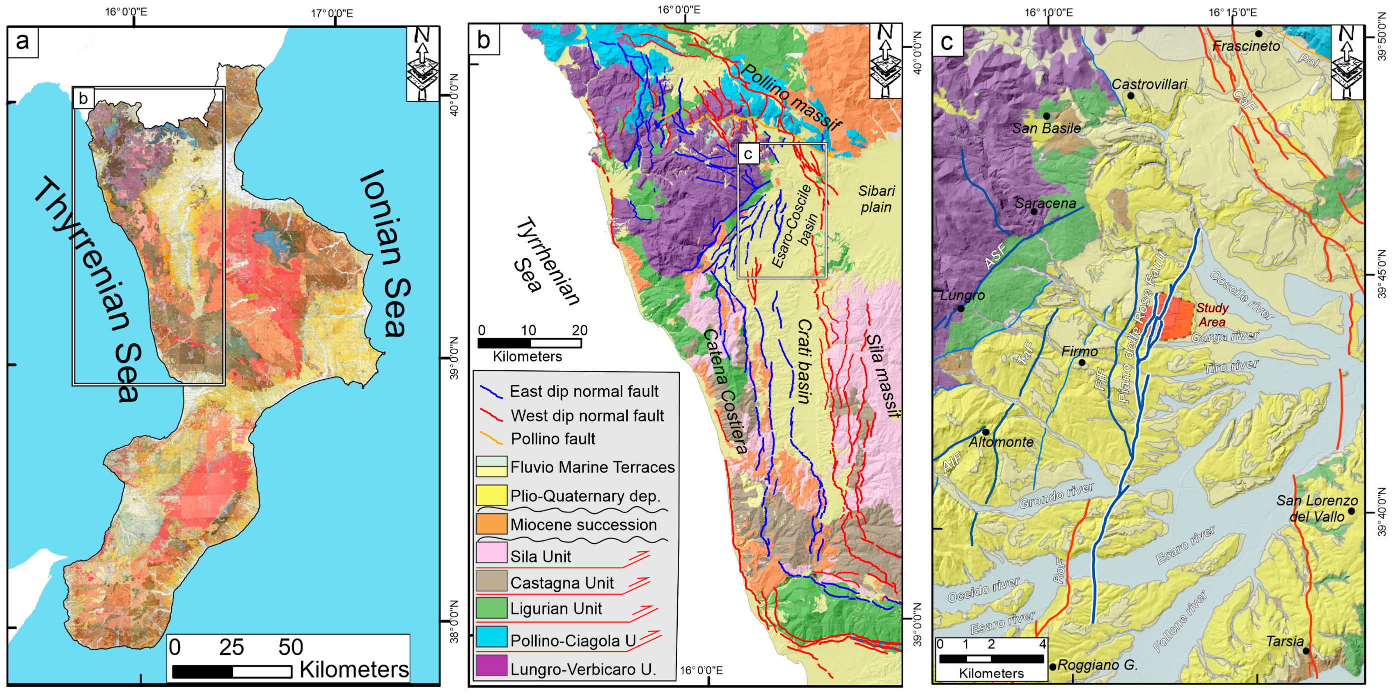
2.2. Sedimentary Stratigraphy of the Crati Graben
2.3. Stratigraphy of the Study Area
3. Materials and Methods
3.1. PPK UAV Photogrammetry
3.2. High-Resolution Topography
3.3. Field Survey
3.4. GIS Geomorphological Analysis
3.5. Soils Analysis
4. Results
4.1. Topographic Profile
4.2. Fault Displacement Analysis/Field Survey Sites/Kinematic
4.3. Field Soil Features
4.4. Chemical and Physical Data
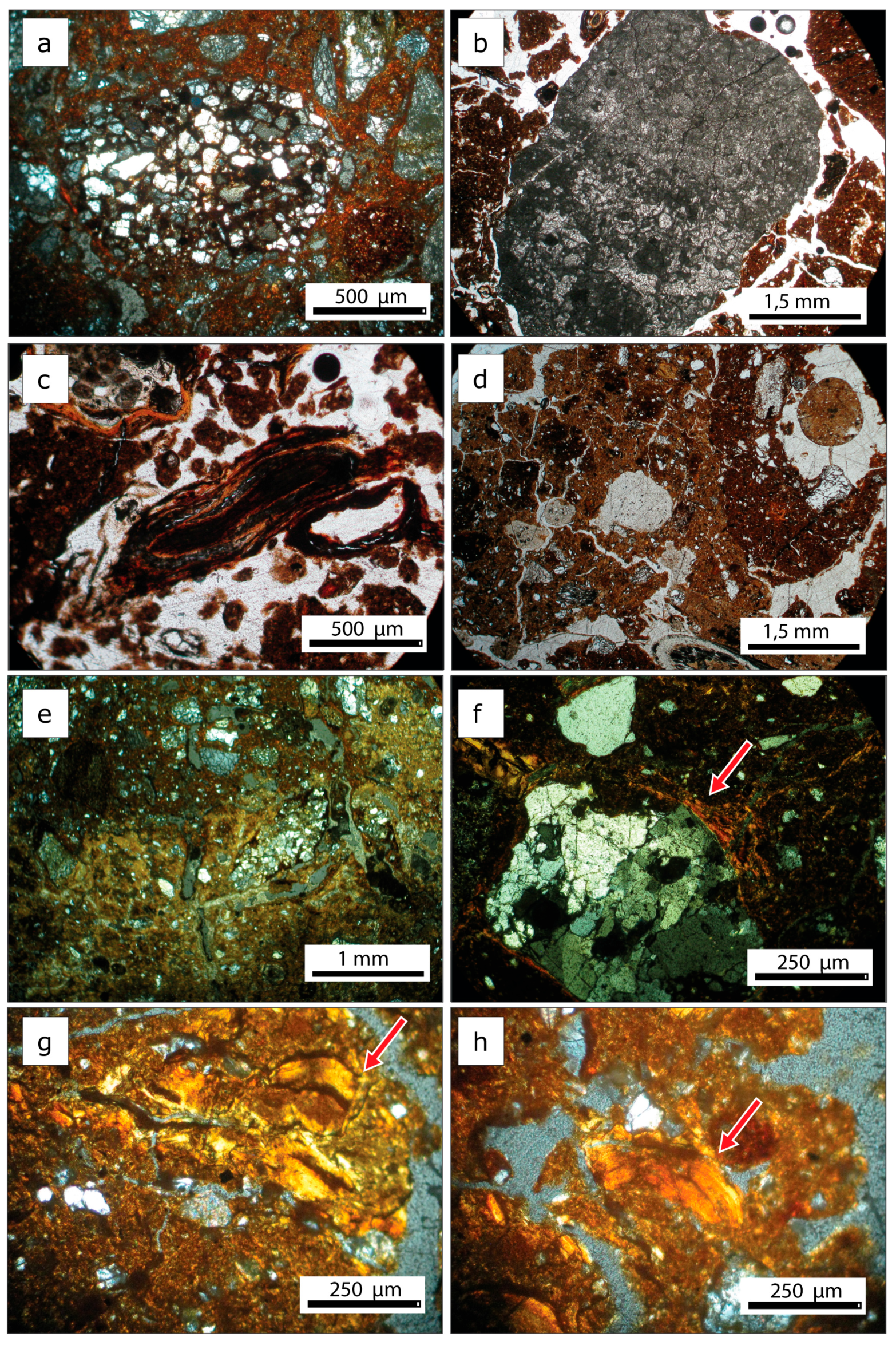
4.5. Micromorphology
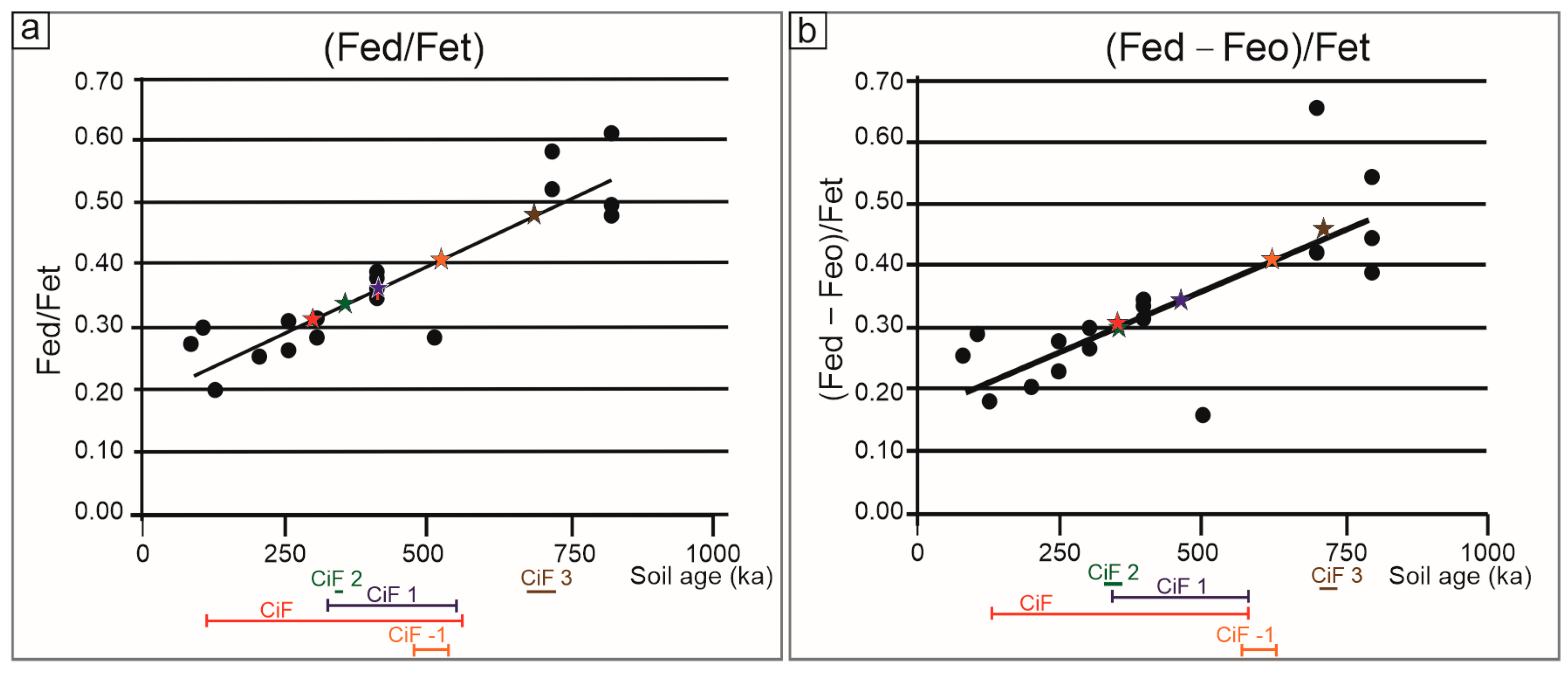
4.6. Selective Estraction and Pedogenic Iron Indices
5. Discussion
5.1. Correlation of Marine and Fluvio-Lacustrine Terraces
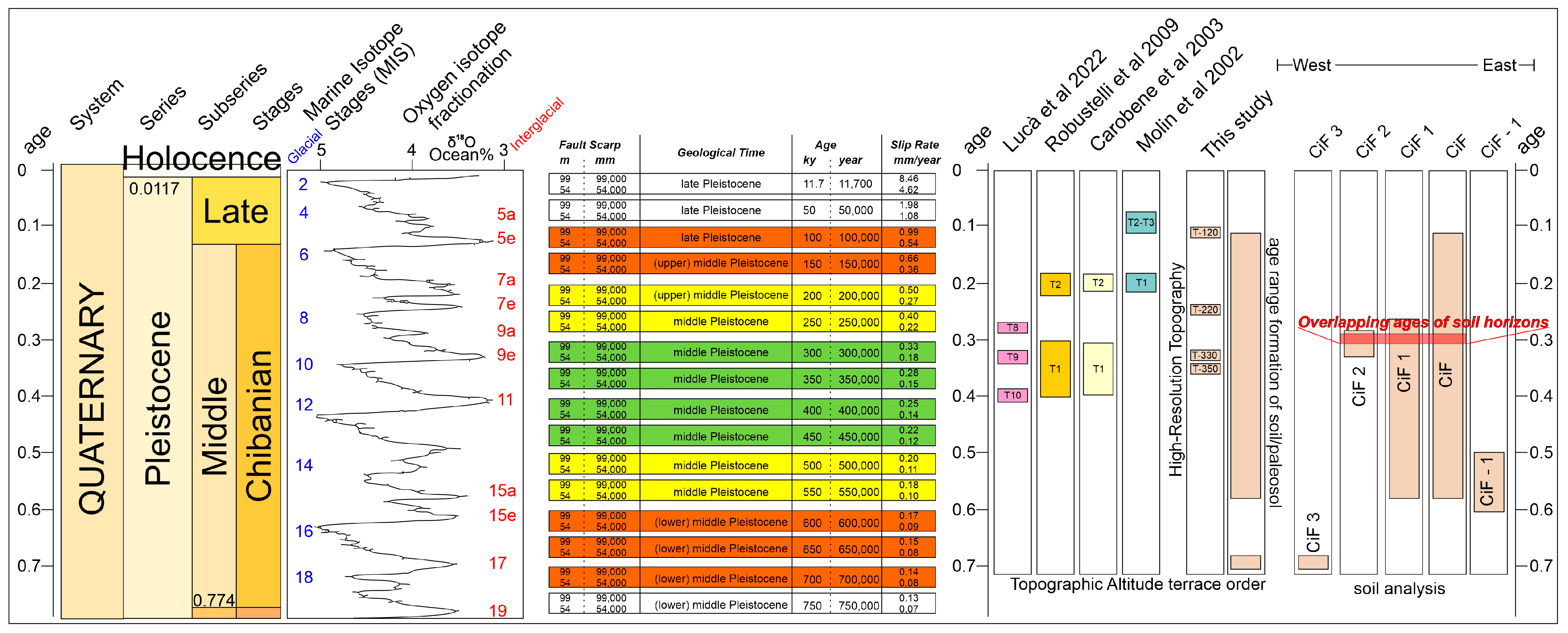
5.2. Soil and Paleosol Chronology
5.3. Fault Activity and Slip Rate Estimation
5.4. Seismotectonic Implications
6. Conclusions
Author Contributions
Funding
Data Availability Statement
Acknowledgments
Conflicts of Interest
References
- Casula, G. Geodynamics of the Calabrian Arc area (Italy) inferred from a dense GNSS network observations. Geod. Geodyn. 2016, 7, 76–86. [Google Scholar] [CrossRef]
- Faccenna, C.; Becker, T.W.; Lucente, F.P.; Jolivet, L.; Rossetti, F. History of subduction and back-arc extension in the Central Mediterranean. Geophys. J. Int. 2001, 145, 809–820. [Google Scholar] [CrossRef]
- Filice, F.; Seeber, L. The Culmination of an Oblique Time-Transgressive Arc Continent Collision: The Pollino Massif Between Calabria and the Southern Apennines, Italy. Tectonics 2019, 38, 3261–3280. [Google Scholar] [CrossRef]
- Brozzetti, F.; Cirillo, D.; de Nardis, R.; Cardinali, M.; Lavecchia, G.; Orecchio, B.; Presti, D.; Totaro, C. Newly identified active faults in the Pollino seismic gap, southern Italy, and their seismotectonic significance. J. Struct. Geol. 2017, 94, 13–31. [Google Scholar] [CrossRef]
- Brozzetti, F.; Cirillo, D.; Liberi, F.; Piluso, E.; Faraca, E.; De Nardis, R.; Lavecchia, G. Structural style of Quaternary extension in the Crati Valley (Calabrian Arc): Evidence in support of an east-dipping detachment fault. Ital. J. Geosci. 2017, 136, 434–453. [Google Scholar] [CrossRef]
- Tortorici, L.; Monaco, C.; Tansi, C.; Cocina, O. Recent and active tectonics in the Calabrian arc (Southern Italy). Tectonophysics 1995, 243, 37–55. [Google Scholar] [CrossRef]
- Tansi, C.; Iovine, G.; Folino Gallo, M. Tettonica attiva e recente, e manifestazioni gravitative profonde, lungo il bordo orientale del graben del Fiume Crati (Calabria settentrionale). Boll. Soc. Geol. It. 2005, 124, 563–578. [Google Scholar]
- Tansi, C.; Tallarico, A.; Iovine, G.; Folino Gallo, M.; Falcone, G. Interpretation of radon anomalies in seismotectonic and tectonic-gravitational settings: The south-eastern Crati graben (Northern Calabria, Italy). Tectonophysics 2005, 396, 181–193. [Google Scholar] [CrossRef]
- Tansi, C.; Muto, F.; Critelli, S.; Iovine, G. Neogene-Quaternary strike-slip tectonics in the central Calabrian Arc (southern Italy). J. Geodyn. 2007, 43, 393–414. [Google Scholar] [CrossRef]
- Spina, V.; Tondi, E.; Galli, P.; Mazzoli, S. Fault propagation in a seismic gap area (northern Calabria, Italy): Implications for seismic hazard. Tectonophysics 2009, 476, 357–369. [Google Scholar] [CrossRef]
- Meschis, M.; Teza, G.; Serpelloni, E.; Elia, L.; Lattanzi, G.; Di Donato, M.; Castellaro, S. Refining Rates of Active Crustal Deformation in the Upper Plate of Subduction Zones, Implied by Geological and Geodetic Data: The E-Dipping West Crati Fault, Southern Italy. Remote Sens. 2022, 14, 5303. [Google Scholar] [CrossRef]
- Lavecchia, G.; Bello, S.; Andrenacci, C.; Cirillo, D.; Pietrolungo, F.; Talone, D.; Ferrarini, F.; de Nardis, R.; Galli, P.; Faure Walker, J.; et al. QUIN 2.0—New release of the QUaternary fault strain INdicators database from the Southern Apennines of Italy. Sci Data 2024, 11, 189. [Google Scholar] [CrossRef]
- Cirillo, D.; Totaro, C.; Lavecchia, G.; Orecchio, B.; de Nardis, R.; Presti, D.; Ferrarini, F.; Bello, S.; Brozzetti, F. Structural complexities and tectonic barriers controlling recent seismic activity in the Pollino area (Calabria–Lucania, southern Italy)—Constraints from stress inversion and 3D fault model building. Solid Earth 2022, 13, 205–228. [Google Scholar] [CrossRef]
- Galli, P.; Bosi, V. Catastrophic 1638 earthquakes in Calabria (southern Italy): New insights from paleoseismological investigation: Paleoseismology of Lakes Fault (1638 Earthquake, Italy). J. Geophys. Res. Solid Earth 2003, 108, ETG 1-1–ETG 1-20. [Google Scholar] [CrossRef]
- Galli, P.; Scionti, V. Two unknown M > 6 historical earthquakes revealed by palaeoseismological and archival researches in eastern Calabria (southern Italy). Seismotectonic implications. Terra Nova 2006, 18, 44–49. [Google Scholar] [CrossRef]
- Schiattarella, M. Quaternary tectonics of the Pollino Ridge, Calabria-Lucania boundary, southern Italy. Geol. Soc. Lond. Spec. Publ. 1998, 135, 341–354. [Google Scholar] [CrossRef]
- Ercoli, M.; Cirillo, D.; Pauselli, C.; Jol, H.M.; Brozzetti, F. Ground-penetrating radar signature of Quaternary faulting: A study from the Mt. Pollino region, southern Apennines, Italy. Solid Earth 2021, 12, 2573–2596. [Google Scholar] [CrossRef]
- Bello, S.; Perna, M.G.; Consalvo, A.; Brozzetti, F.; Galli, P.; Cirillo, D.; Andrenacci, C.; Tangari, A.C.; Carducci, A.; Menichetti, M.; et al. Coupling rare earth element analyses and high-resolution topography along fault scarps to investigate past earthquakes: A case study from the Southern Apennines (Italy). Geosphere 2023, 19, 1348–1371. [Google Scholar] [CrossRef]
- Boncio, P.; Auciello, E.; Amato, V.; Aucelli, P.; Petrosino, P.; Tangari, A.C.; Jicha, B.R. Late Quaternary faulting in the southern Matese (Italy): Implications for earthquake potential and slip rate variability in the southern Apennines. Solid Earth 2022, 13, 553–582. [Google Scholar] [CrossRef]
- Galli, P.A.C.; Peronace, E. Low slip rates and multimillennial return times for Mw 7 earthquake faults in southern Calabria (Italy). Geophys. Res. Lett. 2015, 42, 5258–5265. [Google Scholar] [CrossRef]
- Battistelli, M.; Ferrarini, F.; Bucci, F.; Santangelo, M.; Cardinali, M.; Boncori, J.P.M.; Cirillo, D.; Carafa, M.M.C.; Brozzetti, F. Bridging the Gap Between Active Faulting and Deformation Across Normal-Fault Systems in the Central-Southern Apennines (Italy): Multi-Scale and Multi-Source Data Analysis. Remote Sens. 2025, 17, 2491. [Google Scholar] [CrossRef]
- Galli, P. Recurrence times of central-southern Apennine faults (Italy): Hints from palaeoseismology. Terra Nova 2020, 32, 399–407. [Google Scholar] [CrossRef]
- Gilbert, G.K. Earthquake Forecasts Introduction. Science 1909, 29, 121–138. [Google Scholar] [CrossRef] [PubMed][Green Version]
- Gupta, H.K. Himalayan Seismic Belt, Seismic Gaps and Related Issues. J. Geol. Soc. India 2023, 99, 1187–1190. [Google Scholar] [CrossRef]
- Napolitano, F.; Gabrielli, S.; De Siena, L.; Amoroso, O.; Capuano, P. Imaging overpressurised fracture networks and geological barriers hindering fluid migrations across a slow-deformation seismic gap. Sci. Rep. 2023, 13, 19680. [Google Scholar] [CrossRef]
- Totaro, C.; Presti, D.; Billi, A.; Gervasi, A.; Orecchio, B.; Guerra, I.; Neri, G. The Ongoing Seismic Sequence at the Pollino Mountains, Italy. Seismol. Res. Lett. 2013, 84, 955–962. [Google Scholar] [CrossRef]
- Passarelli, L.; Hainzl, S.; Cesca, S.; Maccaferri, F.; Mucciarelli, M.; Roessler, D.; Corbi, F.; Dahm, T.; Rivalta, E. Aseismic transient driving the swarm-like seismic sequence in the Pollino range, Southern Italy. Geophys. J. Int. 2015, 201, 1553–1567. [Google Scholar] [CrossRef]
- Napolitano, F.; Galluzzo, D.; Gervasi, A.; Scarpa, R.; La Rocca, M. Fault imaging at Mt Pollino (Italy) from relative location of microearthquakes. Geophys. J. Int. 2020, 224, 637–648. [Google Scholar] [CrossRef]
- Napolitano, F.; Amoroso, O.; La Rocca, M.; Gervasi, A.; Gabrielli, S.; Capuano, P. Crustal Structure of the Seismogenic Volume of the 2010–2014 Pollino (Italy) Seismic Sequence From 3D P- and S-Wave Tomographic Images. Front. Earth Sci. 2021, 9, 735340. [Google Scholar] [CrossRef]
- Sketsiou, P.; De Siena, L.; Gabrielli, S.; Napolitano, F. 3-D attenuation image of fluid storage and tectonic interactions across the Pollino fault network. Geophys. J. Int. 2021, 226, 536–547. [Google Scholar] [CrossRef]
- Guerra, I.; Harabaglia, P.; Gervasi, A.; Rosa, A.B. The 1998-1999 Pollino (Southern Apennines, Italy) seismic crisis: Tomography of a sequence. Ann. Geophys. 2009, 48, 995–1007. [Google Scholar] [CrossRef]
- Chiarabba, C.; Agostinetti, N.P.; Bianchi, I. Lithospheric fault and kinematic decoupling of the Apennines system across the Pollino range. Geophys. Res. Lett. 2016, 43, 3201–3207. [Google Scholar] [CrossRef]
- Pastori, M.; Margheriti, L.; De Gori, P.; Govoni, A.; Lucente, F.P.; Moretti, M.; Marchetti, A.; Di Giovambattista, R.; Anselmi, M.; De Luca, P.; et al. The 2011–2014 Pollino Seismic Swarm: Complex Fault Systems Imaged by 1D Refined Location and Shear Wave Splitting Analysis at the Apennines–Calabrian Arc Boundary. Front. Earth Sci. 2021, 9, 618293. [Google Scholar] [CrossRef]
- Cinti, F.R.; Moro, M.; Pantosti, D.; Cucci, L.; D’Addezio, G. New constraints on the seismic history of the Castrovillari fault in the Pollino gap (Calabria, southern Italy). journal of seismology 2002, 6, 199–217. [Google Scholar] [CrossRef]
- Rovida, A.; Locati, M.; Camassi, R.; Lolli, B.; Gasperini, P. The Italian earthquake catalogue CPTI15. Bull. Earthq. Eng. 2020, 18, 2953–2984. [Google Scholar] [CrossRef]
- Rovida, A.; Locati, M.; Camassi, R.; Lolli, B.; Gasperini, P.; Antonucci, A. Catalogo Parametrico dei Terremoti Italiani (CPTI15), versione 4.0. Istituto Nazionale di Geofisica e Vulcanologia (INGV): Rome, Italy, 2022. [Google Scholar] [CrossRef]
- Brozzetti, F.; Lavecchia, G.; Mancini, G.; Milana, G.; Cardinali, M. Analysis of the 9 September 1998 Mw 5.6 Mercure earthquake sequence (Southern Apennines, Italy): A multidisciplinary approach. Tectonophysics 2009, 476, 210–225. [Google Scholar] [CrossRef]
- Calderoni, G.; Ponte, M.; La Rocca, M.; Di Giovambattista, R. Influence of Fluids and Geological Setting on Source Parameters of the 2010-2014 Pollino (Italy) Seismic Swarm. Terra Nova 2025, 37, 324–341. [Google Scholar] [CrossRef]
- Tertulliani, A.; Cucci, L. New Insights on the Strongest Historical Earthquake in the Pollino Region (Southern Italy). Seismol. Res. Lett. 2014, 85, 743–751. [Google Scholar] [CrossRef]
- Guidoboni, E.; Ferrari, G.; Tarabusi, G.; Sgattoni, G.; Comastri, A.; Mariotti, D.; Ciuccarelli, C.; Bianchi, M.G.; Valensise, G. CFTI5Med, the new release of the catalogue of strong earthquakes in Italy and in the Mediterranean area. Sci. Data 2019, 6, 80. [Google Scholar] [CrossRef] [PubMed]
- Lavecchia, G.; de Nardis, R.; Ferrarini, F.; Cirillo, D.; Bello, S.; Brozzetti, F. Regional seismotectonic zonation of hydrocarbon fields in active thrust belts: A case study from Italy. In Building Knowledge for Geohazard Assessment and Management in the Caucasus and Other Orogenic Regions; Bonali, F.L., Mariotto, F.P., Tsereteli, N., Eds.; Springer: Dordrecht, The Netherlands, 2021; pp. 89–128. [Google Scholar] [CrossRef]
- Rossetti, F.; Goffé, B.; Monié, P.; Faccenna, C.; Vignaroli, G. Alpine orogenic P-T-t-deformation history of the Catena Costiera area and surrounding regions (Calabrian Arc, southern Italy): The nappe edifice of north Calabria revised with insights on the Tyrrhenian-Apennine system formation: Alpine tectonics in north Calabria. Tectonics 2004, 23, 1–26. [Google Scholar] [CrossRef]
- Malinverno, A.; Ryan, W.B.F. Extension in the Tyrrhenian Sea and shortening in the Apennines as result of arc migration driven by sinking of the lithosphere. Tectonics 1986, 5, 227–245. [Google Scholar] [CrossRef]
- Vitale, S.; Ciarcia, S. Tectono-stratigraphic and kinematic evolution of the southern Apennines/Calabria–Peloritani Terrane system (Italy). Tectonophysics 2013, 583, 164–182. [Google Scholar] [CrossRef]
- Rosolino, C.; Eugenio, F.; Patrizia, F.; Gaetano, O.; Antonino, P.; Rosalda, P. The Calabria-Peloritani Orogen, a composite terrane in Central Mediterranean; its overall architecture and geodynamic significance for a pre-Alpine scenario around the Tethyan basin. Period. Di Mineral. 2015, 84, 701–749. [Google Scholar] [CrossRef]
- Amodio-Morelli, L.; Bonardi, G.; Colonna, V.; Dietrich, D.; Giunta, G.; Ippolito, F.; Liguori, V.; Lorenzoni, F.; Paglionico, A.; Perrone, V.; et al. L’arco calabro-peloritano nell’orogene appenninico-maghrebide Translated Title: The Calabro-Peloritani Arc during the Apennine-Maghrebide Orogeny. Mem. Soc. Geol. Ital. 1976, 17, 1–60. [Google Scholar]
- Filice, F.; Liberi, F.; Cirillo, D.; Pandolfi, L.; Marroni, M.; Piluso, E. Geology map of the central area of Catena Costiera: Insights into the tectono-metamorphic evolution of the Alpine belt in Northern Calabria. J. Maps 2015, 11, 114–125. [Google Scholar] [CrossRef]
- Cesarano, M.; Turco, E. Folding within Upper Miocene deposits of the Calabrian Coast Range (Southern Italy). Boll. Soc. Geol. Ital. Vol Spec 2002, 1, 677–685. [Google Scholar]
- Scrocca, D.; Doglioni, C.; Innocenti, F. Contraints for an interpretation of the italian geodynamics: A review. Mem. Descr. Della Carta Geol. D’Italia 2003, 62, 1–32. [Google Scholar]
- Bonardi, G. Oligocene-to-Early Miocene depositional and structural evolution of the Calabria–Peloritani Arc southern terrane (Italy) and geodynamic correlations with the Spain Betics and Morocco Rif. Geodin. Acta 2003, 16, 149–169. [Google Scholar] [CrossRef]
- Patacca, E.; Scandone, P. Geology of the Southern Apennines. Boll. Della Soc. Geol. Ital. 2007, 7, 75–119. [Google Scholar]
- Cifelli, F.; Mattei, M.; Rossetti, F. Tectonic evolution of arcuate mountain belts on top of a retreating subduction slab: The example of the Calabrian Arc. J. Geophys. Res. 2007, 112, B09101. [Google Scholar] [CrossRef]
- Montone, P.; Mariucci, M.T. The new release of the Italian contemporary stress map. Geophys. J. Int. 2016, 205, 1525–1531. [Google Scholar] [CrossRef]
- D’Agostino, N.; D’Anastasio, E.; Gervasi, A.; Guerra, I.; Nedimovic, M.R.; Seeber, L.; Steckler, M. Forearc extension and slow rollback of the Calabrian Arc from GPS measurements. Geophys. Res. Lett. 2011, 38, L17304. [Google Scholar] [CrossRef]
- Carafa, M.M.C.; Kastelic, V.; Bird, P.; Maesano, F.E.; Valensise, G. A “Geodetic Gap” in the Calabrian Arc: Evidence for a Locked Subduction Megathrust? Geophys. Res. Lett. 2018, 45, 1794–1804. [Google Scholar] [CrossRef]
- Ghisetti, F.; Vezzani, L. Structural Map of Mt. Pollino (Southern Italy). 1:50.000 Scale; SELCA: Florence, Italy, 1983. [Google Scholar]
- Monaco, C.; Tortorici, L.; Morten, L.; Critelli, S.; Tansi, C. Geologia del versante nord-orientale del Massiccio del Pollino (confine calabro-lucano); nota illustrativa sintetica della carta geologica alla scala 1: 50.000. Boll. Della Soc. Geol. Ital. 1995, 114, 277–291. [Google Scholar]
- Nazzareni, S.; Mantovani, L.; Pizzati, M.; Bersani, D.; Boschetti, T.; Palmucci, A.; Cirillo, D.; Brozzetti, F. Characterisation of Fault-Related Mn-Fe Striae on the Timpa Della Manca Fault (Mercure Basin, Southern Apennines, Italy). Geosciences 2024, 14, 299. [Google Scholar] [CrossRef]
- Ietto, A.; Ietto, F. Carta Geologica d’Italia, Foglio 543—Cassano allo Ionio. 2011. Available online: http://www.isprambiente.gov.it/Media/carg/543_CASSANO_ALLO_IONIO/Foglio.html (accessed on 14 July 2025).
- Servizio Geologico d’Italia. Carta geologica della Calabria alla scala 1:25.000— Geological Map of Calabria at 1:25.000 scale. In Cassa per il Mezzogiorno—CASMEZ; Servizio Geologico d’Italia: Poligrafica & Cartevalori Ercolano (Napoli): Napoly, Italy, 1971. [Google Scholar]
- Cifelli, F.; Rossetti, F.; Mattei, M. The architecture of brittle postorogenic extension: Results from an integrated structural and paleomagnetic study in north Calabria (southern Italy). Geol. Soc. Am. Bull. 2007, 119, 221–239. [Google Scholar] [CrossRef]
- Brozzetti, F.; Cirillo, D.; Liberi, F.; Piluso, E. The Crati valley extensional system: Field and subsurface evidences. Rend. Onl. Soc. Geol. It. 2012, 21, 159–161. [Google Scholar]
- Lanzafame, G.; Zuffa, G.; Frazzetta, G.; Sorriso, M. Carta geologica del Bacino del Crati. Foglio. Litografia Artistica Cartografica: Florence, Italy, 1975. [Google Scholar]
- Galli, P.; Galadini, F.; Pantosti, D. Twenty years of paleoseismology in Italy. Earth-Sci. Rev. 2008, 88, 89–117. [Google Scholar] [CrossRef]
- Galli, P.; Giaccio, B.; Messina, P.; Peronace, E. Three magnitude 7 earthquakes on a single fault in central Italy in 1400 years, evidenced by new palaeoseismic results. Terra Nova 2016, 28, 146–154. [Google Scholar] [CrossRef]
- Galli, P.; Messina, P.; Peronace, E.; Galderisi, A.; Ilardo, I.; Polpetta, F. Paleoseismic evidence of five magnitude 7 earthquakes on the Norcia fault system in the past 8,000 years (Central Italy). Front. Earth Sci. 2023, 11, 1188602. [Google Scholar] [CrossRef]
- Lanzafame, G.; Zuffa, G. Geologia e petrografia del Foglio Bisignano (Bacino del Crati, Calabria). Geol. Romana 1976, 15, 223–270. [Google Scholar]
- Romeo, M.; Tortorici, L. Stratigrafia dei depositi miocenici della Catena Costiera calabra meridionale e della media Valle del F. Crati (Calabria). Boll. Soc. Geol. It 1980, 99, 303–318. [Google Scholar]
- Colella, A.; De Boer, P.L.; Nio, S.D. Sedimentology of a marine intermontane Pleistocene Gilbert-type fan-delta complex in the Crati Basin, Calabria, southern Italy. Sedimentology 1987, 34, 721–736. [Google Scholar] [CrossRef]
- Colella, A. Fault-controlled marine Gilbert-type fan deltas. Geology 1988, 16, 1031. [Google Scholar] [CrossRef]
- Fabbricatore, D.; Robustelli, G.; Muto, F. Facies analysis and depositional architecture of shelf-type deltas in the Crati Basin (Calabrian Arc, south Italy). Ital. J. Geosci. 2014, 133, 131–148. [Google Scholar] [CrossRef]
- Robustelli, G.; Muto, F. The Crati River Basin: Geomorphological and stratigraphical data for the Plio-Quaternary evolution of northern Calabria, South Apennines, Italy. Geol. Carpathica 2017, 68, 68–79. [Google Scholar] [CrossRef]
- Cirillo, D.; Cerritelli, F.; Agostini, S.; Bello, S.; Lavecchia, G.; Brozzetti, F. Integrating Post-Processing Kinematic (PPK)–Structure-from-Motion (SfM) with Unmanned Aerial Vehicle (UAV) Photogrammetry and Digital Field Mapping for Structural Geological Analysis. ISPRS Int. J. Geo-Inf. 2022, 11, 437. [Google Scholar] [CrossRef]
- Cirillo, D.; Zappa, M.; Tangari, A.C.; Brozzetti, F.; Ietto, F. Rockfall Analysis from UAV-Based Photogrammetry and 3D Models of a Cliff Area. Drones 2024, 8, 31. [Google Scholar] [CrossRef]
- Cirillo, D. Digital Field Mapping and Drone-Aided Survey for Structural Geological Data Collection and Seismic Hazard Assessment: Case of the 2016 Central Italy Earthquakes. Appl. Sci. 2020, 10, 5233. [Google Scholar] [CrossRef]
- Cardozo, N.; Allmendinger, R.W. Spherical projections with OSXStereonet. Comput. Geosci. 2013, 51, 193–205. [Google Scholar] [CrossRef]
- Allmendinger, R.W.; Cardozo, N.; Fisher, D.M. Structural Geology Algorithms: Vectors & Tensors. Cambridge, Ed.; Cambridge University Press: Cambridge, UK, 2013; p. 289. [Google Scholar]
- Tarquini, S.; Nannipieri, L. The 10 m-resolution TINITALY DEM as a trans-disciplinary basis for the analysis of the Italian territory: Current trends and new perspectives. Geomorphology 2017, 281, 108–115. [Google Scholar] [CrossRef]
- Tarquini, S.; Isola, I.; Favalli, M.; Battistini, A.; Dotta, G. TINITALY, a digital elevation model of Italy with a 10 meters cell size (Version 1.1). Istituto Nazionale di Geofisica e Vulcanologia (INGV): Rome, Italy, 2023. [Google Scholar] [CrossRef]
- Regione Calabria—Carta Tecnica Regionale in Scala 1:5.000. Available online: https://geoportale.regione.calabria.it/dataset (accessed on 22 February 2025).
- Geoportale Nazionale. Available online: http://www.pcn.minambiente.it/viewer/ (accessed on 22 February 2025).
- FAO. Food and Agriculture Organization—Guidelines for Soil Profile Description, 4th ed.; FAO: Rome, Italy, 2006; p. 97. [Google Scholar]
- Van Reeuwijk, L. Procedures for Soil Analysis; International Soil Reference and Information Centre: Wageningen, The Netherlands, 2002; Volume 9, pp. 1–101. [Google Scholar]
- Burt, R. Soil survey laboratory methods manual. In Soil Survey Investigations Report; Burt, R., Ed.; Usda, NRCS: United States Department of Agriculture–National Resources Conservation Service (USDA–NRSC): Lincoln, NE, USA, 2004; Vol. 42. [Google Scholar]
- Simpson, K. Micromorphology of Soils; Cambridge University Press: London; Chapman and Hall: New York, NY, USA, 1984. [Google Scholar]
- Schwertmann, U. Differenzierung der eisenoxide des bodens durch extraktion mit ammoniumoxalat-Lösung. Z. Für Pflanzenernährung Düngung Bodenkd. 1964, 105, 194–202. [Google Scholar] [CrossRef]
- Mehra, O.; Jackson, M. Iron oxide removal from soils and clays by a dithionite–citrate system buffered with sodium bicarbonate. In Clays and Clay Minerals; Elsevier: Amsterdam, The Netherlands, 2013; pp. 317–327. [Google Scholar]
- Arduino, E.; Barberis, E.; Carraro, F.; Forno, M.G. Estimating relative ages from iron-oxide/total-iron ratios of soils in the western Po Valley, Italy. Geoderma 1984, 33, 39–52. [Google Scholar] [CrossRef]
- Scarciglia, F.; Pelle, T.; Pulice, I.; Robustelli, G. A comparison of Quaternary soil chronosequences from the Ionian and Tyrrhenian coasts of Calabria, southern Italy: Rates of soil development and geomorphic dynamics. Quat. Int. 2015, 376, 146–162. [Google Scholar] [CrossRef]
- Scarciglia, F.; Mercatante, G.; Fondevilla, V.; Anadón, P.; Oms, O.; Donato, P.; Agnini, C.; Papini, M.; Rook, L.; Ghinassi, M. Pleistocene paleosol development and paleoenvironmental dynamics in East Africa: A multiproxy record from the -bearing Aalat pedostratigraphic succession, Dandiero basin (Eritrea). Quat. Sci. Rev. 2018, 191, 275–298. [Google Scholar] [CrossRef]
- Robustelli, G.; Lucà, F.; Corbi, F.; Pelle, T.; Dramis, F.; Fubelli, G.; Scarciglia, F.; Muto, F.; Cugliari, D. Alluvial terraces on the Ionian coast of northern Calabria, southern Italy: Implications for tectonic and sea level controls. Geomorphology 2009, 106, 165–179. [Google Scholar] [CrossRef]
- Torrent, J.; Schwertmann, U.; Schulze, D. Iron oxide mineralogy of some soils of two river terrace sequences in Spain. Geoderma 1980, 23, 191–208. [Google Scholar] [CrossRef]
- Lucà, F.; Brogno, A.; Tripodi, V.; Robustelli, G. Terrace morpho-sedimentary sequences on the sibari plain (Calabria, Southern Italy): Implication for Sea level and tectonic controls. Geosciences 2022, 12, 211. [Google Scholar] [CrossRef]
- Carobene, L. Genesi, età, sollevamento ed erosione dei terrazzi marini di Crosia-Calopezzati (Costa ionica della Calabria-Italia). Alp. Mediterr. Quat. 2003, 16, 43–90. [Google Scholar]
- Molin, P.; Dramis, F.; Lupia Palmieri, E. The Pliocene-Quaternary uplift of the Ionian northern Calabria coastal belt between Corigliano Calabro and Capo Trionto. Studi Geol. Camerti Vol. Spec. 2002, 1, 135–145. [Google Scholar]
- Carobene, L.; Dai-Pra, G.; Gewelt, M. Niveaux marins du Pléistocène moyen-supérieur de la côte tyrrhénienne de la Calabre (Italie méridionale) Datations 230Th/234U et tectonique récente. Z. Für Geomorphologie. Suppl. 1986, 62, 141–158. [Google Scholar]
- Carobene, L.; Dai Pra, G. Genesis, chronology and tectonics of the Quaternary marine terraces of the Tyrrhenian coast of Northern Calabria (Italy). Their correlation with climatic variations. Alp. Mediterr. Quat. 1990, 3, 75–94. [Google Scholar]
- Cucci, L. Raised marine terraces in the Northern Calabrian Arc (Southern Italy): A ∼ 600 kyr-long geological record of regional uplift. Ann. Geophys. 2004, 47, 1391–1406. [Google Scholar]
- Santoro, E.; Mazzella, M.E.; Ferranti, L.; Randisi, A.; Napolitano, E.; Rittner, S.; Radtke, U. Raised coastal terraces along the Ionian Sea coast of northern Calabria, Italy, suggest space and time variability of tectonic uplift rates. Quat. Int. 2009, 206, 78–101. [Google Scholar] [CrossRef]
- Alfonsi, L.; Brunori, C.A.; Cucci, L. Mapping and chronological classification of marine terraces along the southern side of the Sibari Plain (northern Calabria, Italy) by means of digital and analogue tools. J. Maps 2023, 19, 2243983. [Google Scholar] [CrossRef]
- Cinti, F.; Alfonsi, L.; Cucci, L.; Pantosti, D.; Pauselli, C.; Ercoli, M.; Brunori, C.; Cianflone, G.; Dominici, R. The NE-SW Sibari fault zone: A seismic hazard source in Ionian northern Calabria (Italy). Tectonophysics 2024, 873, 230214. [Google Scholar] [CrossRef]
- Carboni, S.; Palomba, M.; Vacca, A.; Carboni, G. Paleosols provide sedimentation, relative age, and climatic information about the alluvial fan of the River Tirso (Central-Western Sardinia, Italy). Quat. Int. 2006, 156, 79–96. [Google Scholar] [CrossRef]
- Coltorti, M.; Pieruccini, P. The last interglacial pedocomplexes in the litho- and morpho-stratigraphical framework of the central-northern Apennines (Central Italy). Quat. Int. 2006, 156, 118–132. [Google Scholar] [CrossRef]
- Scarciglia, F.; Tuccimei, P.; Vacca, A.; Barca, D.; Pulice, I.; Salzano, R.; Soligo, M. Soil genesis, morphodynamic processes and chronological implications in two soil transects of SE Sardinia, Italy: Traditional pedological study coupled with laser ablation ICP-MS and radionuclide analyses. Geoderma 2011, 162, 39–64. [Google Scholar] [CrossRef]
- Di Celma, C.; Pieruccini, P.; Farabollini, P. Major controls on architecture, sequence stratigraphy and paleosols of middle Pleistocene continental sediments ("Qc Unit"), eastern central Italy. Quat. Res. 2015, 83, 565–581. [Google Scholar] [CrossRef]
- Tangari, A.C.; Scarciglia, F.; Piluso, E.; Marinangeli, L.; Pompilio, L. Role of weathering of pillow basalt, pyroclastic input and geomorphic processes on the genesis of the Monte Cerviero upland soils (Calabria, Italy). CATENA 2018, 171, 299–315. [Google Scholar] [CrossRef]
- Bracone, V.; Amorosi, A.; Aucelli, P.P.C.; Rosskopf, C.M.; Scarciglia, F.; Di Donato, V.; Esposito, P. The Pleistocene tectono-sedimentary evolution of the Apenninic foreland basin between Trigno and Fortore rivers (Southern Italy) through a sequence stratigraphic perspective. Basin Res. 2012, 24, 213–233. [Google Scholar] [CrossRef]
- Fedoroff, N. Clay illuviation in Red Mediterranean soils. Catena 1997, 28, 171–189. [Google Scholar] [CrossRef]
- Cremaschi, M.; Trombino, L. The palaeoclimatic significance of paleosols in Southern Fezzan (Libyan Sahara): Morphological and micromorphological aspects. Catena 1998, 34, 131–156. [Google Scholar] [CrossRef]
- Catt, J.A. Report from working group on definitions used in paleopedology. Quat. Int. 1998, 51-52, 84. [Google Scholar] [CrossRef]
- Bronger, A.; Sedov, S.N. Vetusols and paleosols: Natural versus man-induced environmental change in the Atlantic coastal region of Morocco. Quat. Int. 2003, 106, 33–60. [Google Scholar] [CrossRef]
- Scarciglia, F.; Sauer, D.; Zerboni, A. Pleistocene paleosols of Italy: Pedostratigraphy, genesis, paleoclimate and geoarchaeology. Alp. Mediterr. Quat. 2023, 36, 1–35. [Google Scholar] [CrossRef]
- Sauer, D. Approaches to quantify progressive soil development with time in Mediterranean climate-I. Use of field criteria. J Plant Nutr Soil Sc 2010, 173, 822–842. [Google Scholar] [CrossRef]
- Schwertmann, U.; Taylor, R.M. Iron oxides. Miner. Soil Environ. 1989, 1, 379–438. [Google Scholar]
- Harden, J.W. A quantitative index of soil development from field descriptions: Examples from a chronosequence in central California. Geoderma 1982, 28, 1–28. [Google Scholar] [CrossRef]
- Vidic, N.J. Soil-age relationships and correlations: Comparison of chronosequences in the Ljubljana Basin, Slovenia and USA. Catena 1998, 34, 113–129. [Google Scholar] [CrossRef]
- Harden, J.W.; Taylor, E.M. A quantitative comparison of soil development in four climatic regimes. Quat. Res. 1983, 20, 342–359. [Google Scholar] [CrossRef]
- Kendrick, K.J.; McFadden, L.D. Comparison and contrast of processes of soil formation in the San Timoteo Badlands with chronosequences in California. Quat. Res. 1996, 46, 149–160. [Google Scholar] [CrossRef]
- Carafa, M.M.C.; Di Naccio, D.; Di Lorenzo, C.; Kastelic, V.; Bird, P. A Meta-Analysis of Fault Slip Rates Across the Central Apennines. J Geophys Res-Sol Ea 2022, 127, e2021JB023252. [Google Scholar] [CrossRef]
- Wood, H.O. The earthquake problem in the western United States. Bull. Seismol. Soc. Am. 1916, 6, 197–217. [Google Scholar] [CrossRef]
- Slemmons, D.B.; McKinney, R. Definition of "active Fault"; Department of Defense, Department of the Army, Corps of Engineers, Waterways Experiment Station, Soils and Pavements Laboratory: Vicksburg, MS, USA, 1977. [Google Scholar]
- Wood, R.M.; Mallard, D.J. When Is a Fault Extinct. J. Geol. Soc. 1992, 149, 251–255. [Google Scholar] [CrossRef]
- Boschi, E. New trends in active faulting studies for seismic hazard assessment. Ann. Geophys. 1996, 39. [Google Scholar] [CrossRef]
- WSSPC. Active fault definition for the Basin and Range Province; WSSPC (Western States Seismic Policy Council): San Francisco, CA, USA, 1997; p. 3. [Google Scholar]
- NRC US Nuclear Regulatory Commission. Identification and Characterization of Seismic Sources and Determination of Safe Shutdown Earthquake Ground Motion; NRC US Nuclear Regulatory Commission: Rockville, MD, USA, 1997; Vol. 1. [Google Scholar]
- Machette, M.N. Active, capable, and potentially active faults—A paleoseismic perspective. J. Geodyn. 2000, 29, 387–392. [Google Scholar] [CrossRef]
- IAEA-Safety-Standard. Seismic hazards in site evaluation for nuclear installations. Specif. Saf. Guide 2010, 60. [Google Scholar]
- Tondi, E.; Michetti, M.A. The resolution of geological analysis and models for earthquake faulting studies. J. Geodyn. 1998, 145–580. Available online: https://pubblicazioni.unicam.it/handle/11581/250294 (accessed on 22 February 2025).
- Lavecchia, G.; Bello, S.; Andrenacci, C.; Cirillo, D.; Ferrarini, F.; Vicentini, N.; de Nardis, R.; Roberts, G.; Brozzetti, F. Quaternary fault strain Indicators database—QUIN 1.0—first release from the Apennines of central Italy. Sci. Data 2022, 9, 204. [Google Scholar] [CrossRef] [PubMed]
- Galadini, F.; Falcucci, E.; Galli, P.; Giaccio, B.; Gori, S.; Messina, P.; Moro, M.; Saroli, M.; Scardia, G.; Sposato, A. Time intervals to assess active and capable faults for engineering practices in Italy. Eng. Geol. 2012, 139, 50–65. [Google Scholar] [CrossRef]
- Wu, Z.H.; Hu, M.M. Definitions, Classification Schemes for Active Faults, and Their Application. Geosciences 2024, 14, 68. [Google Scholar] [CrossRef]
- Wells, D.L.; Coppersmith, K.J. New Empirical Relationships among Magnitude, Rupture Length, Rupture Width, Rupture Area, and Surface Displacement. Bull. Seismol. Soc. Am. 1994, 84, 974–1002. [Google Scholar] [CrossRef]
- Wesnousky, S.G. Displacement and Geometrical Characteristics of Earthquake Surface Ruptures: Issues and Implications for Seismic-Hazard Analysis and the Process of Earthquake Rupture. Bull. Seismol. Soc. Am. 2008, 98, 1609–1632. [Google Scholar] [CrossRef]
- Stirling, M.; Goded, T.; Berryman, K.; Litchfield, N. Selection of Earthquake Scaling Relationships for Seismic-Hazard Analysis. Bull. Seismol. Soc. Am. 2013, 103, 2993–3011. [Google Scholar] [CrossRef]
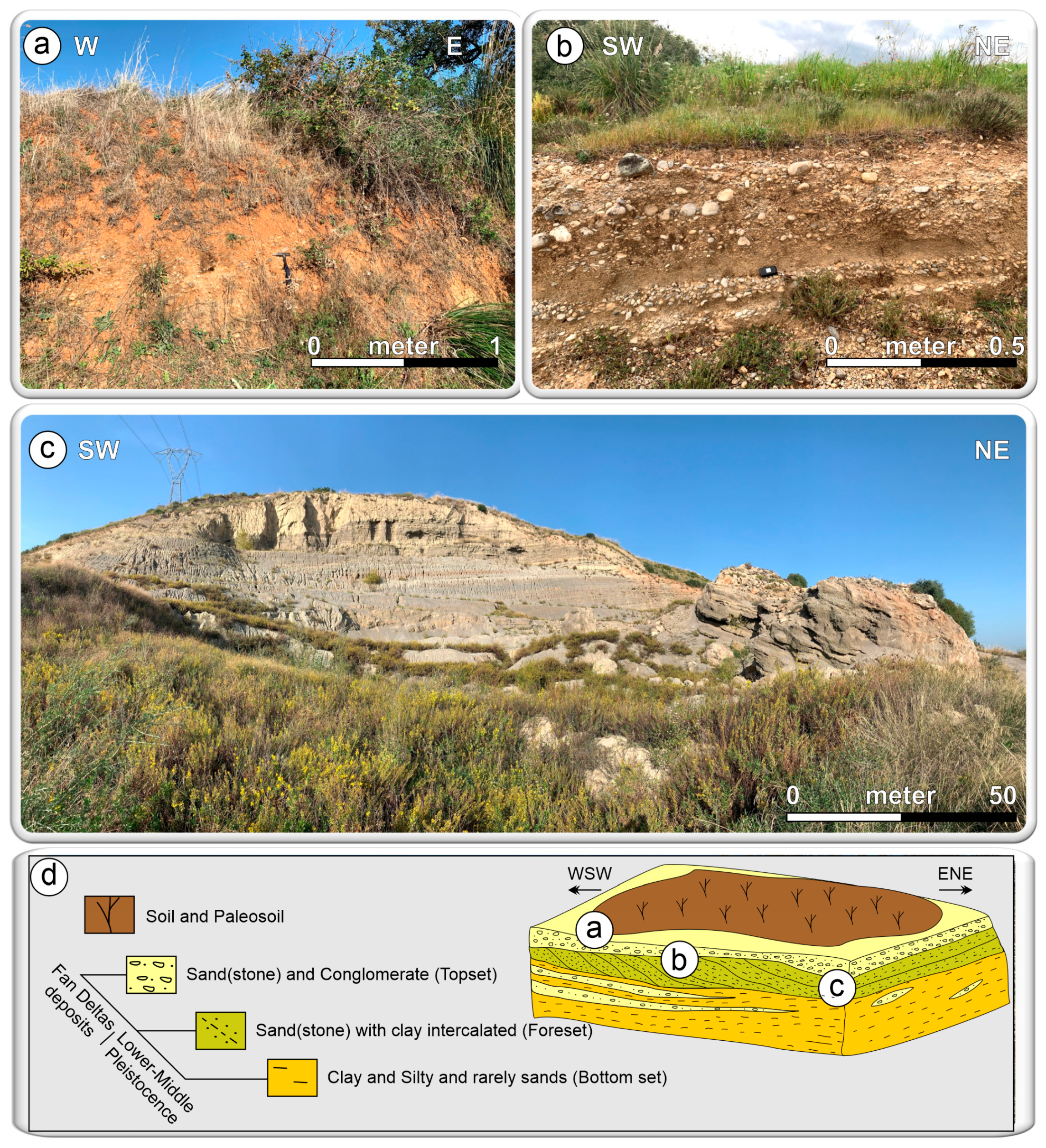
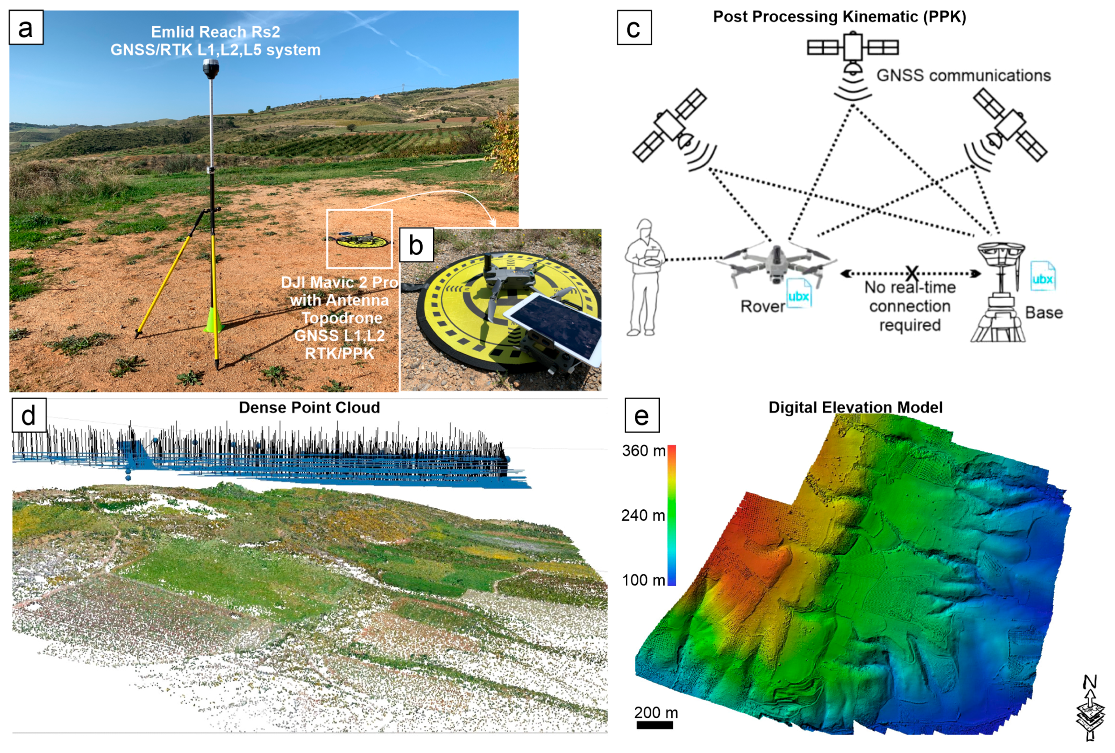
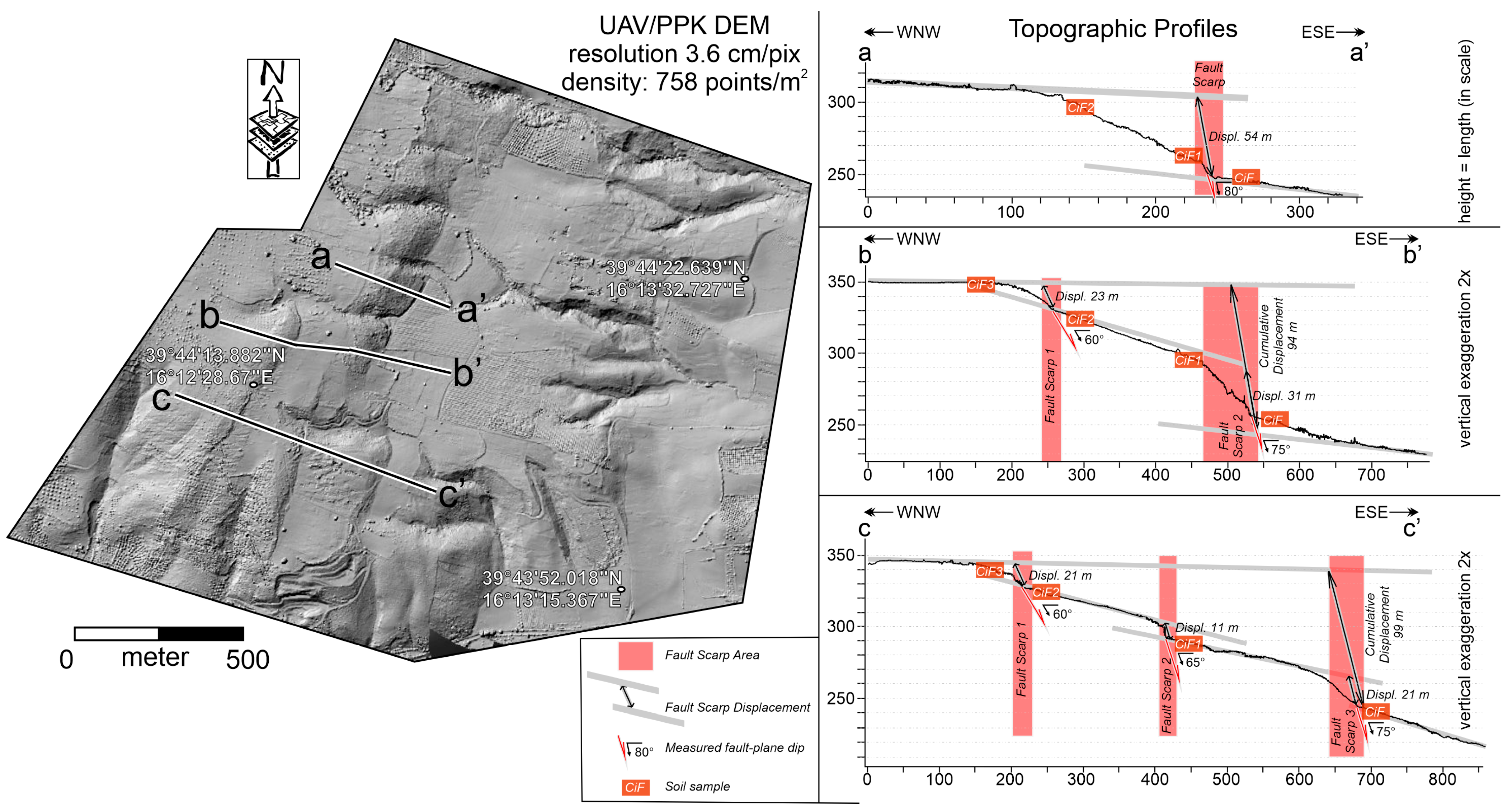

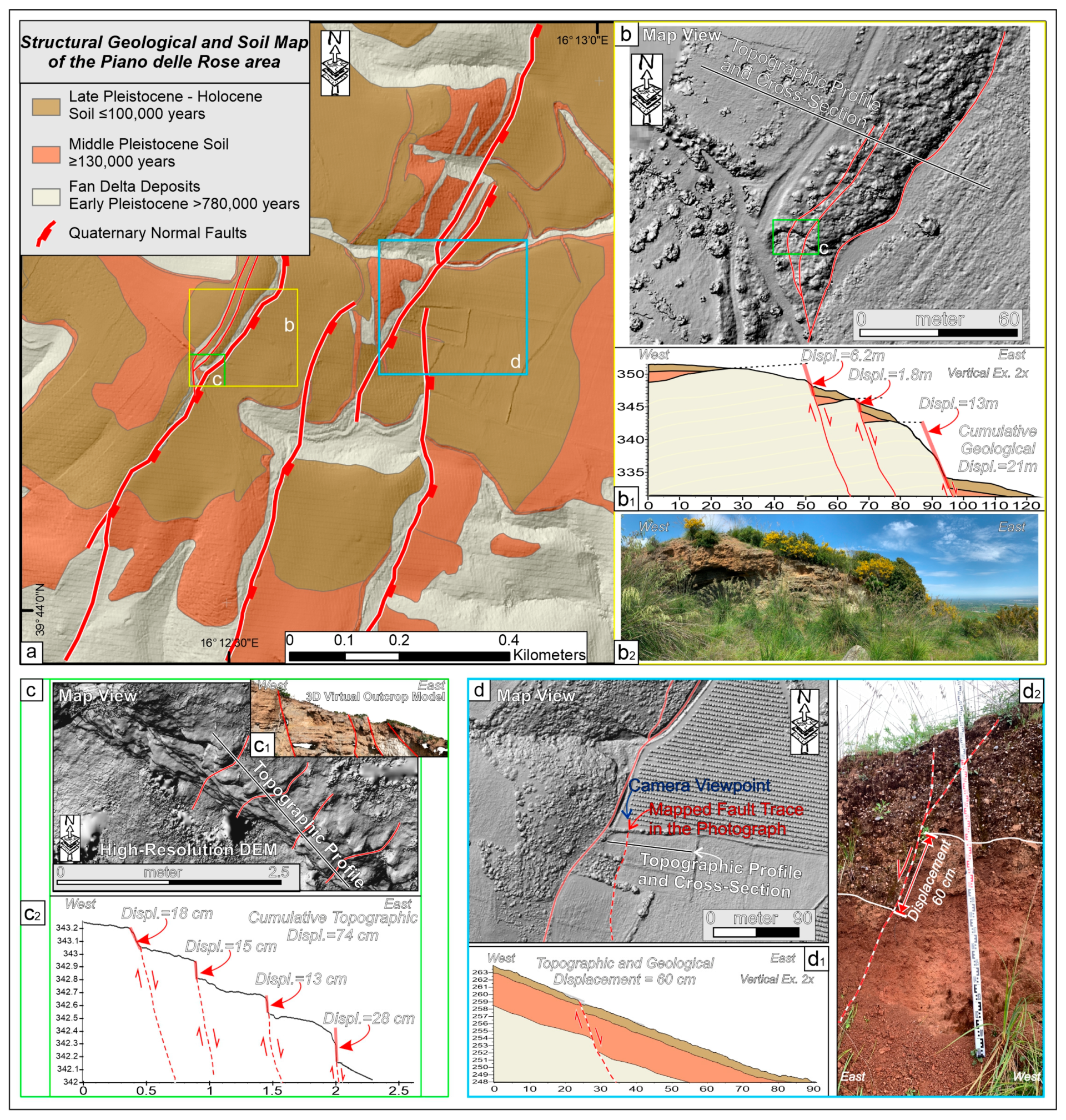

| Topographic Profile and Fault Scarp (F.S.) | Dip (°) | Throw (m) | Displacement (m) | Heave (m) |
|---|---|---|---|---|
| a-a’ | 80 | 53 | 54 | 9 |
| b-b’–F.S. 1 | 60 | 20 | 23 | 12 |
| b-b’–F.S. 2 | 75 | 30 | 31 | 8 |
| b-b’–cumulative F.S. | 70 | 88 | 94 | 32 |
| c-c’–F.S. 1 | 60 | 18 | 21 | 10 |
| c-c’–F.S. 2 | 65 | 10 | 11 | 5 |
| c-c’–F.S. 3 | 75 | 20 | 21 | 5 |
| c-c’–cumulative F.S. | 65 | 90 | 99 | 42 |
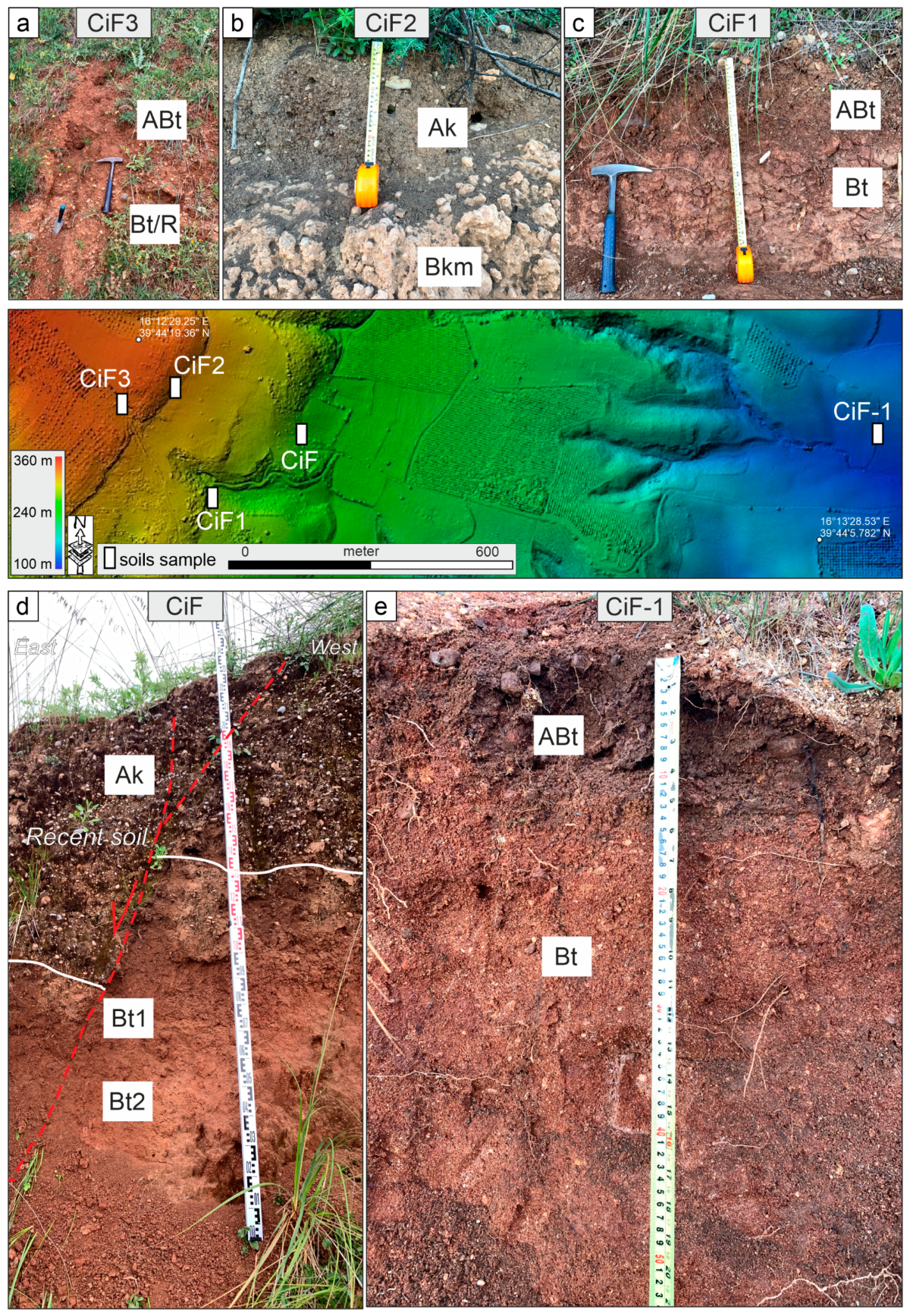
| Soil Profile | Elevation (m asl) | Coordinates | Horizon | Depth (cm) | Color (Dry) | Redness Rating | Structure | Consistence | Clay Coatings (%) | Fe-Mn Features (%) |
|---|---|---|---|---|---|---|---|---|---|---|
| CiF3 | 352 | 39°44′15.80″N 16° 12′27.00"E | ABt | 0−210 | 7.5 YR 5/8 | 4 | CR-SB | m-s | 8−15 | - |
| Bt/R | 210−360+ | 10 YR 5/8−7.5 YR 5/6 | 0−3 | CR-SB | m-s | 10−15 | - | |||
| CiF2 | 339 | 39°44′15.55″N 16° 12′31.68″E | Ak | 0−28 | 7.5 YR 6/4−10YR 5/4 | 1.7−0 | CR-SB | w-s | - | - |
| Bkm | 28−56+ | |||||||||
| CiF1 | 300 | 39°44′08.00"N 16°12′35.24″E | ABt | 0−20/23 | 7.5 YR 5/6−5YR 5/6 | 3−6 | SB-AB | w | 15−20 | 8−10 |
| Bt | 20/23−55 | 7.5 YR 5/8−5YR 5/8 | 4−8 | AB-P | m-s | 30−35 | 10−15 | |||
| CiF | 263 | 39°44′17.11"N 16°12′46.22″E | Ak | 0−160 | 7.5 YR 6/4 | 1.7 | SB-AB | s-vs | - | - |
| Bt1 | 160−183 | 2.5 YR 5/6−5YR 6/6 | 9−5 | SB-AB | w-m | 8−15 | - | |||
| Bt2 | 183−300+ | 2.5 YR 5/6−5YR 5/6 | 9−6 | SB-AB | w-m | 8−15 | 8−10 | |||
| CiF-1 | 116 | 39°44′07.54″N 16°13′52.74″E | ABt | 0−8/10 | 7.5 YR 5/6−10YR 5/8 | 3-0 | CR-SB | w-m | 8−15 | - |
| Bt | 8/10−100+ | 2.5 YR 6/6−7.5YR 6/6 | 7.5−2.5 | SB-AB | w-m | 15−20 | 8−10 |
| Particle Size Distribution | |||||||
|---|---|---|---|---|---|---|---|
| Soil Profile | Horizon | Sand % | Silt % | Clay % | pH (H2O) | O.M % | CSC (cmol(+)/Kg) |
| CiF3 | ABt | 11.3 | 72.7 | 16.0 | 8.1 | 2.1 | 19.6 |
| Bt/R | 43.4 | 38.7 | 18.0 | 8.1 | 1.8 | 16.8 | |
| CiF2 | Ak | 48.8 | 39.2 | 12.0 | 7.9 | 2.2 | 36.3 |
| CiF1 | ABt | 44.9 | 41.1 | 14.0 | 8.0 | 2.3 | 22.7 |
| Bt | 42.4 | 41.6 | 16.0 | 8.0 | 0.5 | 24.0 | |
| CiF | Ak | 71.7 | 22.3 | 6.0 | 8.1 | 0.6 | 6.3 |
| Bt1 | 50.5 | 31.5 | 18.0 | 8.1 | 0.8 | 17.5 | |
| Bt2 | 62.4 | 23.6 | 14.0 | 8.1 | 0.2 | 13.8 | |
| CiF-1 | ABt | 69.4 | 22.6 | 8.0 | 6.8 | 1.8 | 13.8 |
| Bt | 91.8 | 0.20 | 8.0 | 7.1 | 0.3 | 10.1 | |
| Soil Profile | Horizon | Feo% | Fed% | Fet% | Feo/Fed | Fed/Fet | Fet−Fed | (Fed−Feo)/Fet | ∑ ((Fed/Fet)*h/H | ∑ ((Fed−Feo)/Fet)*h/H |
|---|---|---|---|---|---|---|---|---|---|---|
| CiF3 | ABt | 0.06 | 2.28 | 4.69 | 0.03 | 0.49 | 2.41 | 0.47 | 0.48(±0.01) | 0.46 (±0.01) |
| Bt/R | 0.08 | 1.88 | 3.99 | 0.04 | 0.47 | 2.11 | 0.45 | |||
| CiF2 | Ak | 0.09 | 1.59 | 4.68 | 0.06 | 0.34 | 3.09 | 0.32 | 0.34(±0.00) | 0.32(±0.00) |
| CiF1 | ABt | 0.06 | 1.82 | 4.26 | 0.03 | 0.43 | 2.44 | 0.41 | 0.37(±0.05) | 0.35(±0.06) |
| Bt | 0.14 | 1.79 | 5.41 | 0.08 | 0.33 | 3.62 | 0.30 | |||
| CiF | Ak | 0.02 | 0.47 | 2.07 | 0.04 | 0.23 | 1.60 | 0.22 | 0.31(±0.12) | 0.30(±0.11) |
| Bt1 | 0.06 | 1.47 | 4.11 | 0.04 | 0.36 | 2.64 | 0.34 | |||
| Bt2 | 0.06 | 1.53 | 3.59 | 0.04 | 0.43 | 2.06 | 0.41 | |||
| CiF-1 | ABt | 0.10 | 1.20 | 2.69 | 0.08 | 0.45 | 1.49 | 0.41 | 0.41(±0.03) | 0.38(±0.03) |
| Bt | 0.04 | 0.79 | 1.97 | 0.05 | 0.40 | 1.18 | 0.38 |
| Reference | Empirical Scaling Law | Mw |
|---|---|---|
| Wells and Coppersmith [132] | Mw = 5.08 + 1.16 log L | 6.48 |
| Wesnousky [133] | Mw = 6.12 + 0.47 log L | 6.69 |
| Stirling Et Al. [134] | Mw = 5.88 + 0.088 log L | 6.84 |
Disclaimer/Publisher’s Note: The statements, opinions and data contained in all publications are solely those of the individual author(s) and contributor(s) and not of MDPI and/or the editor(s). MDPI and/or the editor(s) disclaim responsibility for any injury to people or property resulting from any ideas, methods, instructions or products referred to in the content. |
© 2025 by the authors. Licensee MDPI, Basel, Switzerland. This article is an open access article distributed under the terms and conditions of the Creative Commons Attribution (CC BY) license (https://creativecommons.org/licenses/by/4.0/).
Share and Cite
Cirillo, D.; Tangari, A.C.; Scarciglia, F.; Lavecchia, G.; Brozzetti, F. UAV-PPK Photogrammetry, GIS, and Soil Analysis to Estimate Long-Term Slip Rates on Active Faults in a Seismic Gap of Northern Calabria (Southern Italy). Remote Sens. 2025, 17, 3366. https://doi.org/10.3390/rs17193366
Cirillo D, Tangari AC, Scarciglia F, Lavecchia G, Brozzetti F. UAV-PPK Photogrammetry, GIS, and Soil Analysis to Estimate Long-Term Slip Rates on Active Faults in a Seismic Gap of Northern Calabria (Southern Italy). Remote Sensing. 2025; 17(19):3366. https://doi.org/10.3390/rs17193366
Chicago/Turabian StyleCirillo, Daniele, Anna Chiara Tangari, Fabio Scarciglia, Giusy Lavecchia, and Francesco Brozzetti. 2025. "UAV-PPK Photogrammetry, GIS, and Soil Analysis to Estimate Long-Term Slip Rates on Active Faults in a Seismic Gap of Northern Calabria (Southern Italy)" Remote Sensing 17, no. 19: 3366. https://doi.org/10.3390/rs17193366
APA StyleCirillo, D., Tangari, A. C., Scarciglia, F., Lavecchia, G., & Brozzetti, F. (2025). UAV-PPK Photogrammetry, GIS, and Soil Analysis to Estimate Long-Term Slip Rates on Active Faults in a Seismic Gap of Northern Calabria (Southern Italy). Remote Sensing, 17(19), 3366. https://doi.org/10.3390/rs17193366


