
The Detection of Small-Scale Open-Burning Agriculture Fires Through Remote Sensing

 , , , , , and
Abstract
1. Introduction
2. Material and Methods
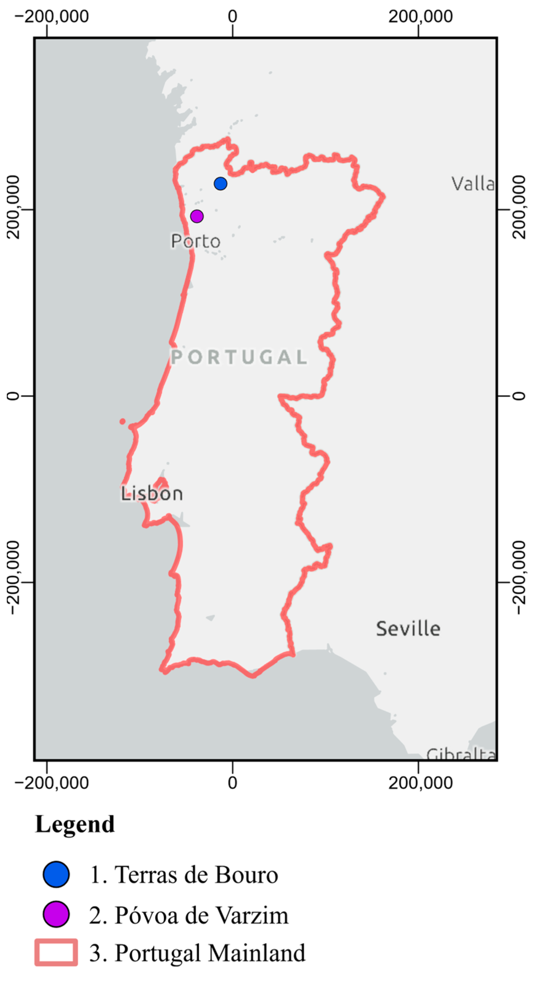
2.1. Case Studies
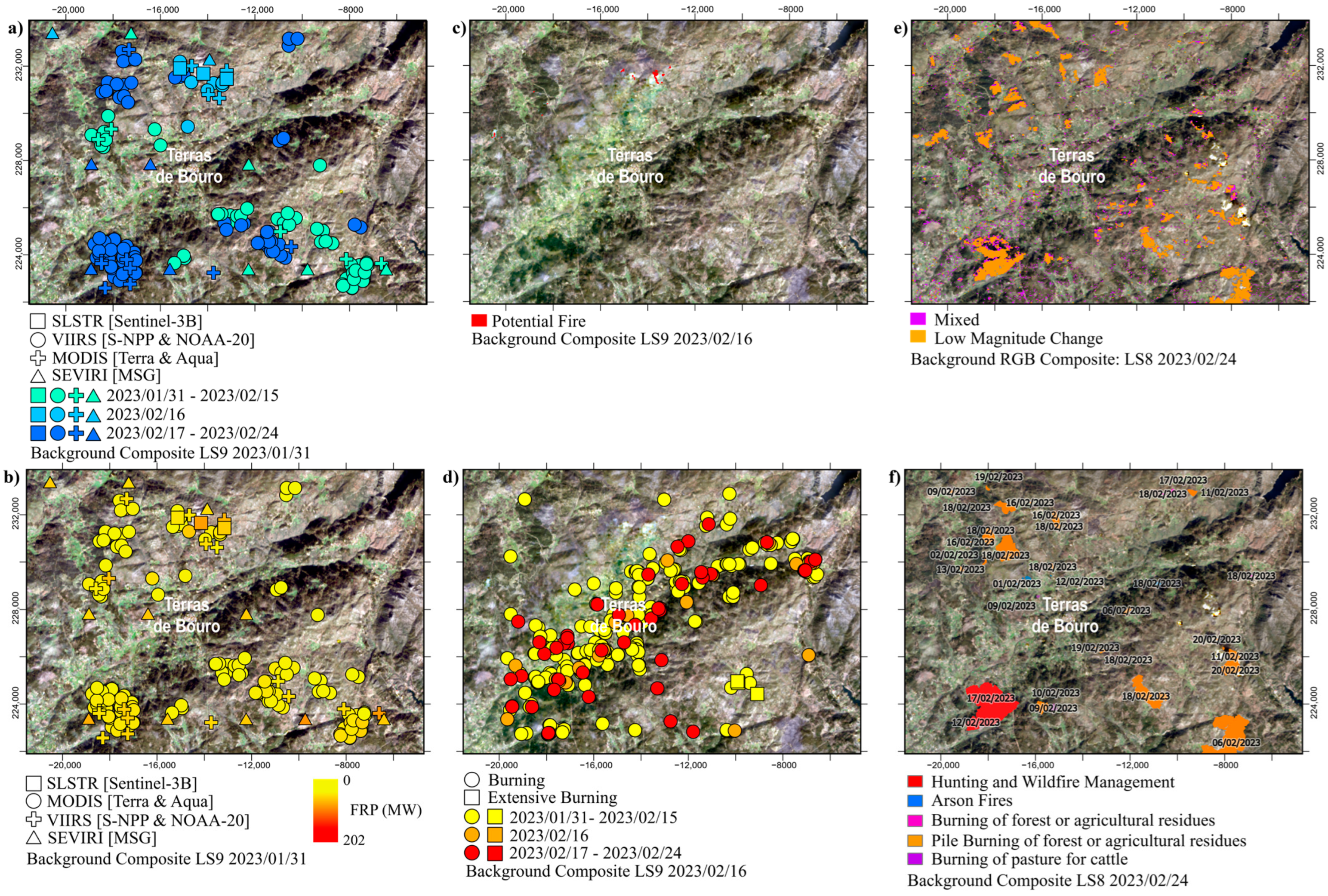
2.1.1. Terras De Bouro
2.1.2. Póvoa De Varzim
2.1.3. Portugal Mainland
2.2. Fire Detection Methods
2.2.1. Active Fire Detections
2.2.2. Estimation of Burned Extents
2.2.3. Active Fire Detections of Agricultural Residue Open-Burning
3. Results
3.1. Terras De Bouro
3.2. Póvoa De Varzim
3.3. Portugal Mainland
4. Discussion
- Not every request resulting in an actual burning;
- Inconsistencies in the reported location coordinates and/or dates (extending beyond the considered spatial and temporal buffers);
- Non-favorable cloudy conditions or haze from fire smoke during the satellite image acquisition, which may prevent accurate or any FRP measurements;
- Insufficient spatial and/or temporal resolutions of the acquiring sensors;
- A combination of one or more of the above-mentioned conditions.
5. Conclusions
Author Contributions
Funding
Institutional Review Board Statement
Informed Consent Statement
Data Availability Statement
Acknowledgments
Conflicts of Interest
References
- Webb, J.; Hutchings, N.; Amon, B.; Nielsen, O.-K.; Phillips, R.; Dämmgen, U. Field Burning of Agricultural Residues. EMEP/EEA Emiss. Invent. Guideb. 2013, 2013, 1–14. [Google Scholar]
- Souza, M.E.B.; Pacheco, A.P.; Teixeira, J.G. Systematising Experts’ Understanding of Traditional Burning in Portugal: A Mental Model Approach. Int. J. Wildl. Fire 2023, 32, 1558–1575. [Google Scholar] [CrossRef]
- Santín, C.; Doerr, S.H. Fire Effects on Soils: The Human Dimension. Philos. Trans. R. Soc. B Biol. Sci. 2016, 371, 28–34. [Google Scholar] [CrossRef]
- Espinosa, J.; Palheiro, P.; Loureiro, C.; Ascoli, D.; Esposito, A.; Fernandes, P.M. Fire-Severity Mitigation by Prescribed Burning Assessed from Fire-Treatment Encounters in Maritime Pine Stands. Can. J. For. Res. 2019, 49, 205–211. [Google Scholar] [CrossRef]
- Antunes, C.C.; Viegas, D.X.; Mendes, J.M.; Em, M.; Sociais, D.; Naturais, R.; Catedrático, P.; Auxiliar, P. Avaliação Do Risco de Incêndio Florestal No Concelho de Arganil. Silva Lusit. 2011, 19, 165–179. [Google Scholar] [CrossRef]
- Xu, Y.; Huang, Z.; Ye, J.; Zheng, J. Hourly Emissions of Air Pollutants and Greenhouse Gases from Open Biomass Burning in China during 2016–2020. Sci. Data 2023, 10, 629. [Google Scholar] [CrossRef] [PubMed]
- López-Caravaca, A.; Vicente, E.D.; Figueiredo, D.; Evtyugina, M.; Nicolás, J.F.; Yubero, E.; Galindo, N.; Ryšavý, J.; Alves, C.A. Gaseous and Aerosol Emissions from Open Burning of Tree Pruning and Hedge Trimming Residues: Detailed Composition and Toxicity. Atmos. Environ. 2024, 338, 120849. [Google Scholar] [CrossRef]
- Alves, C.A.; Vicente, E.D.; Evtyugina, M.; Vicente, A.; Pio, C.; Amado, M.F.; Mahía, P.L. Gaseous and Speciated Particulate Emissions from the Open Burning of Wastes from Tree Pruning. Atmos. Res. 2019, 226, 110–121. [Google Scholar] [CrossRef]
- Gonçalves, C.; Evtyugina, M.; Alves, C.; Monteiro, C.; Pio, C.; Tomé, M. Organic Particulate Emissions from Field Burning of Garden and Agriculture Residues. Atmos. Res. 2011, 101, 666–680. [Google Scholar] [CrossRef]
- Pearson, P.; Bodin, S.; Gittelson, A.; Kinney, S.; McCarty, J.L.; Stevenson, G.; Albertengo, J. Fire in the Fields: Moving Beyond the Damage of Open Agricultural Burning on Communities, Soil, and the Cryosphere Fire in the Fields: Moving Beyond the Damage of Open Agricultural Burning on Communities, Soil, and the Cryosphere. A CCAC Project Summary Report: Impacts and Reduction of Open Burning in the Andes, Himalayas—and Globally; Co-Authors for ICCI: Fire in the Fields: Moving Beyond the Damage of Open Agricultural Burning on Communities, Soil, and the Cryosphere; Climate and Clean Air Coalition to Reduce Short-Lived Climate Pollutants (CCAC): Paris, France, 2015. [Google Scholar] [CrossRef]
- Parente, J.; Girona-García, A.; Lopes, A.R.; Keizer, J.J.; Vieira, D.C.S. Prediction, Validation, and Uncertainties of a Nation-Wide Post-Fire Soil Erosion Risk Assessment in Portugal. Sci. Rep. 2022, 12, 2945. [Google Scholar] [CrossRef]
- Nunes, L.J.R.; Raposo, M.A.M.; Meireles, C.I.R.; Gomes, C.J.P.; Ribeiro, N.M.C.A. The Impact of Rural Fires on the Development of Invasive Species: Analysis of a Case Study with Acacia Dealbata Link. in Casal Do Rei (Seia, Portugal). Environment 2021, 8, 44. [Google Scholar] [CrossRef]
- Han, X.; Frey, G.E.; Sun, C. Regulation and Practice of Forest-Management Fires on Private Lands in the Southeast United States: Legal Open Burns versus Certified Prescribed Burns. J. For. 2020, 118, 385–402. [Google Scholar] [CrossRef]
- Fernandes, P.M.; Botelho, H.S. A Review of Prescribed Burning Effectiveness in Fire Hazard Reduction. Int. J. Wildl. Fire 2003, 12, 117–128. [Google Scholar] [CrossRef]
- Hmielowski, T.L.; Carter, S.K.; Spaul, H.; Helmers, D.P.; Radeloff, V.C.; Zedler, P.H. Prioritizing Land Management Efforts at a Landscape Scale: A Case Study Using Prescribed Fire in Wisconsin. Ecol. Appl. 2015, 26, 1018–1029. [Google Scholar] [CrossRef] [PubMed]
- Matin, M.A.; Chitale, V.S.; Murthy, M.S.R.; Uddin, K.; Bajracharya, B.; Pradhan, S. Understanding Forest Fire Patterns and Risk in Nepal Using Remote Sensing, Geographic Information System and Historical Fire Data. Int. J. Wildl. Fire 2017, 26, 276. [Google Scholar] [CrossRef]
- Schroeder, W.; Oliva, P.; Giglio, L.; Csiszar, I.A. The New VIIRS 375m Active Fire Detection Data Product: Algorithm Description and Initial Assessment. Remote Sens. Environ. 2014, 143, 85–96. [Google Scholar] [CrossRef]
- Schroeder, W.; Oliva, P.; Giglio, L.; Quayle, B.; Lorenz, E.; Morelli, F. Active Fire Detection Using Landsat-8/OLI Data. Remote Sens. Environ. 2016, 185, 210–220. [Google Scholar] [CrossRef]
- Vilar, L.; Camia, A.; San-Miguel-Ayanz, J. A Comparison of Remote Sensing Products and Forest Fire Statistics for Improving Fire Information in Mediterranean Europe. Eur. J. Remote Sens. 2015, 48, 345–364. [Google Scholar] [CrossRef]
- Hall, J.V.; Loboda, T.V.; Giglio, L.; McCarty, G.W. A MODIS-Based Burned Area Assessment for Russian Croplands: Mapping Requirements and Challenges. Remote Sens. Environ. 2016, 184, 506–521. [Google Scholar] [CrossRef]
- Liu, T.; Mickley, L.J.; Singh, S.; Jain, M.; DeFries, R.S.; Marlier, M.E. Crop Residue Burning Practices across North India Inferred from Household Survey Data: Bridging Gaps in Satellite Observations. Atmos. Environ. X 2020, 8, 100091. [Google Scholar] [CrossRef]
- Murphy, S.W.; de Souza Filho, C.R.; Wright, R.; Sabatino, G.; Correa Pabon, R. HOTMAP: Global Hot Target Detection at Moderate Spatial Resolution. Remote Sens. Environ. 2016, 177, 78–88. [Google Scholar] [CrossRef]
- Kumar, S.S.; Roy, D.P. Global Operational Land Imager Landsat-8 Reflectance-Based Active Fire Detection Algorithm. Int. J. Digit. Earth 2018, 11, 154–178. [Google Scholar] [CrossRef]
- Hu, X.; Ban, Y.; Nascetti, A. Sentinel-2 MSI Data for Active Fire Detection in Major Fire-Prone Biomes: A Multi-Criteria Approach. Int. J. Appl. Earth Obs. Geoinf. 2021, 101, 102347. [Google Scholar] [CrossRef]
- Kavzoglu, T.; Erdemir, M.Y.; Tonbul, H. Evaluating Performances of Spectral Indices for Burned Area Mapping Using Object-Based Image Analysis. In Proceedings of the 11th International Symposium on Spatial Accuracy 2016, East Lansing, MI, USA, 8–11 July 2016; pp. 1–7. [Google Scholar]
- Chuvieco, E.; Martín, M.P.; Palacios, A. Assessment of Different Spectral Indices in the Red-near-Infrared Spectral Domain for Burned Land Discrimination. Int. J. Remote Sens. 2002, 23, 5103–5110. [Google Scholar] [CrossRef]
- Oliveira, E.R.; Disperati, L.; Alves, F.L. A New Method (MINDED-BA) for Automatic Detection of Burned Areas Using Remote Sensing. Remote Sens. 2021, 13, 5164. [Google Scholar] [CrossRef]
- Jahanianfard, D.; Parente, J.; Gonzalez-Pelayo, O.; Benali, A. Multidecadal Satellite-Derived Portuguese Burn Severity Atlas (1984–2022). Earth Syst. Sci. Data 2024, 2024, 1–33. [Google Scholar]
- de Oliveira, E.; Colaço, M.C.; Fernandes, P.M.; Sequeira, A.C. Remains of Traditional Fire Use in Portugal: A Historical Analysis. Trees For. People 2023, 14, 100458. [Google Scholar] [CrossRef]
- Amorim, J.H.; Valente, J.; Cascão, P.; Ribeiro, L.M.; Viegas, D.X.; Ottmar, R.; Miranda, A.I. Near-Source Grid-Based Measurement of CO and PM2.5 Concentration during a Full-Scale Fire Experiment in Southern European Shrubland. Atmos. Environ. 2016, 145, 19–28. [Google Scholar] [CrossRef]
- Miranda, A.I.; Martins, V.; Cascão, P.; Amorim, J.H.; Valente, J.; Tavares, R.; Borrego, C.; Tchepel, O.; Ferreira, A.J.; Cordeiro, C.R.; et al. Monitoring of Firefighters Exposure to Smoke during Fire Experiments in Portugal. Environ. Int. 2010, 36, 736–745. [Google Scholar] [CrossRef]
- Jaffe, D.A.; O’Neill, S.M.; Larkin, N.K.; Holder, A.L.; Peterson, D.L.; Halofsky, J.E.; Rappold, A.G. Wildfire and Prescribed Burning Impacts on Air Quality in the United States. J. Air Waste Manag. Assoc. 2020, 70, 583–615. [Google Scholar] [CrossRef] [PubMed]
- ICNF Cartografia Nacional de Áreas Ardidas Dos Anos 1975 à Data Atual Em Conformidade Com o Disposto No n.° 5 Do Art.° 2.° Do Decreto-Lei no 124/2006, de 28 de Junho, Na Redação Dada Pelo Decreto-Lei n.° 17/2009, de 14 de Janeiro. Available online: https://sigservices.icnf.pt/server/rest/services/BDG/areas_ardidas/MapServer (accessed on 1 October 2024).
- Wooster, M.J.; Roberts, G.J.; Giglio, L.; Roy, D.; Freeborn, P.; Boschetti, L.; Justice, C.; Ichoku, C.; Schroeder, W.; Davies, D.; et al. Satellite Remote Sensing of Active Fires: History and Current Status, Applications and Future Requirements. Remote Sens. Environ. 2021, 267, 112694. [Google Scholar] [CrossRef]
- NASA. NASA Active Fire Data. Available online: https://www.earthdata.nasa.gov/learn/find-data/near-real-time/firms/active-fire-data (accessed on 1 October 2024).
- ESA. SLSTR Products. Available online: https://sentiwiki.copernicus.eu/web/slstr-products#S3-SLSTR-Products-L2-FRP-Products (accessed on 1 October 2024).
- Eumetsat LSA SAF. Available online: https://datalsasaf.lsasvcs.ipma.pt/PRODUCTS/MSG/FRP-PIXEL/HDF5/ (accessed on 1 October 2024).
- USGS. Landsat 8 Data Users Handbook; Department of the Interior U.S. Geological Survey: Sioux Falls, SD, USA, 2019; Volume 8.
- USGS. Landsat 9 Data Users Handbook Landsat 9 Data Users Handbook Version 1.0; Department of the Interior U.S. Geological Survey: Sioux Falls, SD, USA, 2022.
- NASA Layer Information: LANDSAT OLI (8 & 9) Fire and Thermal Anomalies (Day|Night, 30 Meters). Available online: https://firms.modaps.eosdis.nasa.gov/descriptions/FIRMS_Landsat_Firehotspots.html (accessed on 1 October 2024).
- Barmpoutis, P.; Papaioannou, P.; Dimitropoulos, K.; Grammalidis, N. A Review on Early Forest Fire Detection Systems Using Optical Remote Sensing. Sensors 2020, 20, 6442. [Google Scholar] [CrossRef]
- Oliveira, E.R.; Disperati, L.; Alves, F.L. MINDED-FBA: An Automatic Remote Sensing Tool for the Estimation of Flooded and Burned Areas. Remote Sens. 2023, 15, 724. [Google Scholar] [CrossRef]
- Oliveira, E.R.; Disperati, L.; Cenci, L.; Pereira, L.G.; Alves, F.L. Multi-Index Image Differencing Method (MINDED) for Flood Extent Estimations. Remote Sens. 2019, 11, 1305. [Google Scholar] [CrossRef]
- ESA. Sentinel-2 User Handbook; ESA: Paris, France, 2015; Volume 2. [Google Scholar]
- APA. Surface Water Bodies Rivers of Mainland Portugal: SNIAmb Spatial Data Set. Available online: https://data.europa.eu/data/datasets/massas-de-agua-superficiais-rios-de-portugal-continental-conjunto-de-dados-geografico-sniamb?locale=en (accessed on 1 October 2024).
- JAXA ALOS Global Digital Surface Model “ALOS World 3D–30 m (AW3D30)”. Available online: https://www.eorc.jaxa.jp/ALOS/en/dataset/aw3d30/aw3d30_e.htm (accessed on 18 January 2023).
- USGS. Earth Explorer. Available online: https://earthexplorer.usgs.gov/ (accessed on 12 November 2020).
- Copernicus Copernicus Browser. Available online: https://browser.dataspace.copernicus.eu/ (accessed on 1 October 2024).
- Congalton, R.G. A Review of Assessing the Accuracy of Classifications of Remotely Sensed Data. Remote Sens. Environ. 1991, 37, 35–46. [Google Scholar] [CrossRef]


| Instrument | Satellite | Spatial Resolution | Temporal Resolution | FRP |
|---|---|---|---|---|
| VIIRS | S-NPP | 375 m | 1 day | VNP14IMGTDL_NRT [35] VJ114IMGTDL_NRT [35] |
| NOAA-20 | ||||
| MODIS | Terra | 1000 m | 1 day | MOD14ML [35] MYD14ML [35] |
| Aqua | ||||
| SLSTR | Sentinel-3A Sentinel-3B | 1000 m | 2–3 day | S3A_SL_2_FRP [36] S3B_SL_2_FRP [36] |
| SEVIRI | MSG 1 | 3100 m | 15 min | LSA SAF SEVIRI FRP-PIXEL [37] |
| Case Study | Pre-Event Scene | Post-Event Scene |
|---|---|---|
| Terras de Bouro | Landsat 9 OLI-2 31 January 2023 | Landsat 8 OLI 24 February 2023 |
| Póvoa de Varzim | Sentinel-2B MSI 28 February 2023 | Sentinel-2A MSI 15 March 2023 |
| Case Study | Date | FRP | SR | ||||||
|---|---|---|---|---|---|---|---|---|---|
| VIIRS | MODIS | SLSTR | SEVIRI | Landsat 9 | |||||
| S-NPP | NOAA-20 | Terra | Aqua | Sentinel 3A | Sentinel 3B | MSG * | OLI-2 | ||
| Terras de Bouro | 16 February 2023 | 02:12–02:18 † 13:36–13:42 † | 01:18–01:24 03:00–03:06 12:42–12:48 † 14:24–14:30 † | 10:50–10:55 † 21:55–22:00 | 02:10–02:15 13:15–13:20 † | 11:02–11:07 † 22:22–22:27 | 00:15; 09:30; 09:45; 10:00; 10:15; 11:00; 11:30; 12:00; 13:30; 13:45; 14:15; 14:30; 15:00; 15:30; 15:45; 16:15; 19:00; 19:15; 20:00; 21:00; 23:30 | 11:13–11:14 † | |
| Póvoa de Varzim | 2 March 2023 | 02:48–02:54 12:30–12:36 14:12–14:18 | 01:54–02:00 03:36–03:42 13:18–13:24 † | 10:35–10:40 21:40–21:45 | 02:10–02:15 02:15–02:20 13:20–13:25 | 10:39–10:42 21:59–22:02 | 10:48–10:51 22:08–22:11 | - | - |
| 4 March 2023 | 02:12–02:18 13:36–13:42 † | 01:18–01:24 03:00–03:06 12:42–12:48 † 14:24–14:30 | 10:15–10:20 11:55–12:00 21:20–21:25 21:25–21:30 23:00–23:05 | 02:00–02:05 03:35–03:40 13:05–13:10 14:45–14:50 | 10:39–10:42 21:59–22:02 | 10:48–10:51 22:08–22:11 | |||
| Without Spatial Buffer | Buffer 10 m | Buffer 100 m | ||||||||
|---|---|---|---|---|---|---|---|---|---|---|
| 0 d | ±1 d | ±1 w | 0 d | ±1 d | ±1 w | 0 d | ±1 d | ±1 w | ||
| Instrument | VIIRS | 54 | 104 | 344 | 56 | 108 | 352 | 67 | 125 | 419 |
| MODIS | 312 | 494 | 1087 | 331 | 524 | 1147 | 472 | 769 | 1703 | |
| SEVIRI | 3044 | 8648 | 46,384 | 3071 | 8710 | 46,720 | 3324 | 9508 | 50,323 | |
| Total | 3410 | 9246 | 47,815 | 3458 | 9342 | 48,219 | 3863 | 10,402 | 52,445 | |
| Without Spatial Buffer | Buffer 10 m | Buffer 100 m | ||||||||
|---|---|---|---|---|---|---|---|---|---|---|
| 0 d | ±1 d | ±1 w | 0 d | ±1 d | ±1 w | 0 d | ±1 d | ±1 w | ||
| Individual request type | Burning | 1239 | 3173 | 14,475 | 1255 | 3214 | 14,604 | 1406 | 3562 | 15,887 |
| Extensive | 132 | 160 | 222 | 136 | 166 | 229 | 154 | 186 | 254 | |
| Total | 1371 | 3333 | 14,697 | 1391 | 3380 | 14,833 | 1560 | 3748 | 16,141 | |
Disclaimer/Publisher’s Note: The statements, opinions and data contained in all publications are solely those of the individual author(s) and contributor(s) and not of MDPI and/or the editor(s). MDPI and/or the editor(s) disclaim responsibility for any injury to people or property resulting from any ideas, methods, instructions or products referred to in the content. |
© 2024 by the authors. Licensee MDPI, Basel, Switzerland. This article is an open access article distributed under the terms and conditions of the Creative Commons Attribution (CC BY) license (https://creativecommons.org/licenses/by/4.0/).
Share and Cite
Oliveira, E.R.; Silva, B.T.; Lopes, D.; Corticeiro, S.; Alves, F.L.; Disperati, L.; Gama, C. The Detection of Small-Scale Open-Burning Agriculture Fires Through Remote Sensing. Remote Sens. 2025, 17, 51. https://doi.org/10.3390/rs17010051
Oliveira ER, Silva BT, Lopes D, Corticeiro S, Alves FL, Disperati L, Gama C. The Detection of Small-Scale Open-Burning Agriculture Fires Through Remote Sensing. Remote Sensing. 2025; 17(1):51. https://doi.org/10.3390/rs17010051
Chicago/Turabian StyleOliveira, Eduardo R., Bárbara T. Silva, Diogo Lopes, Sofia Corticeiro, Fátima L. Alves, Leonardo Disperati, and Carla Gama. 2025. "The Detection of Small-Scale Open-Burning Agriculture Fires Through Remote Sensing" Remote Sensing 17, no. 1: 51. https://doi.org/10.3390/rs17010051
APA StyleOliveira, E. R., Silva, B. T., Lopes, D., Corticeiro, S., Alves, F. L., Disperati, L., & Gama, C. (2025). The Detection of Small-Scale Open-Burning Agriculture Fires Through Remote Sensing. Remote Sensing, 17(1), 51. https://doi.org/10.3390/rs17010051