

Multi-Horizon Predictive Soil Mapping of Historical Soil Properties Using Remote Sensing Imagery


Abstract
1. Introduction
2. Materials and Methods
2.1. Study Area
2.2. Soil Data
2.3. Remote Sensing Data
2.4. Bare Soil Composite Imagery
2.5. Terrain Attributes
2.6. Validation Data
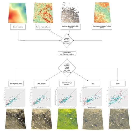
2.7. Model Development
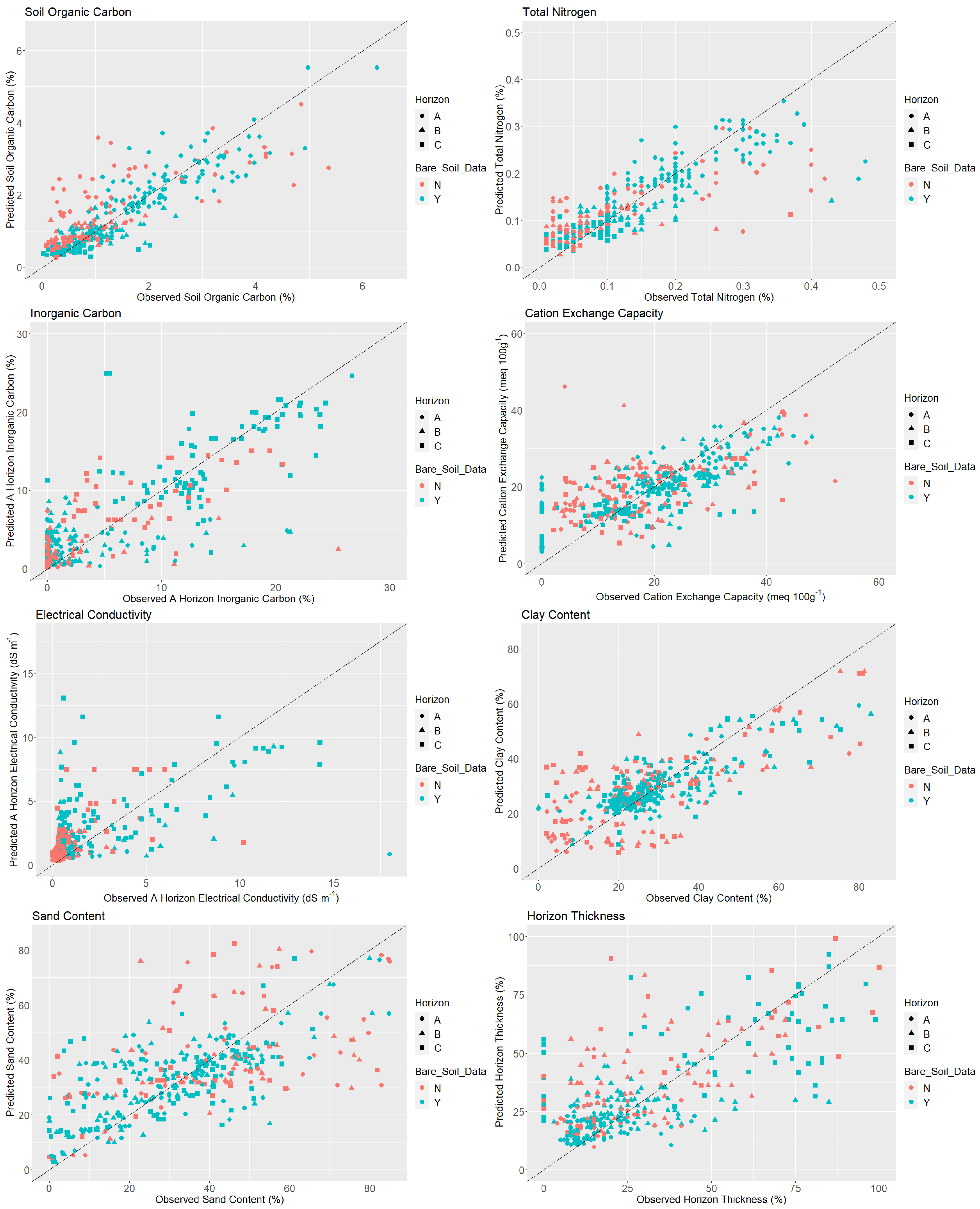
- Soil organic carbon,
- Total nitrogen,
- Cation exchange capacity,
- Electrical conductivity,
- Inorganic carbon,
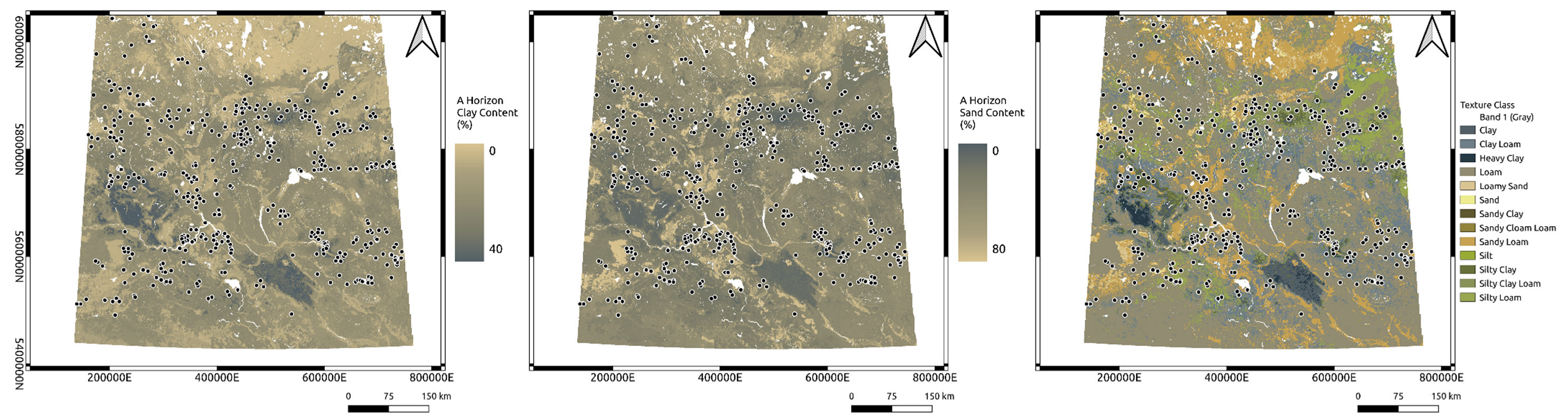
- Sand content,
- Clay content,
- Horizon thickness,
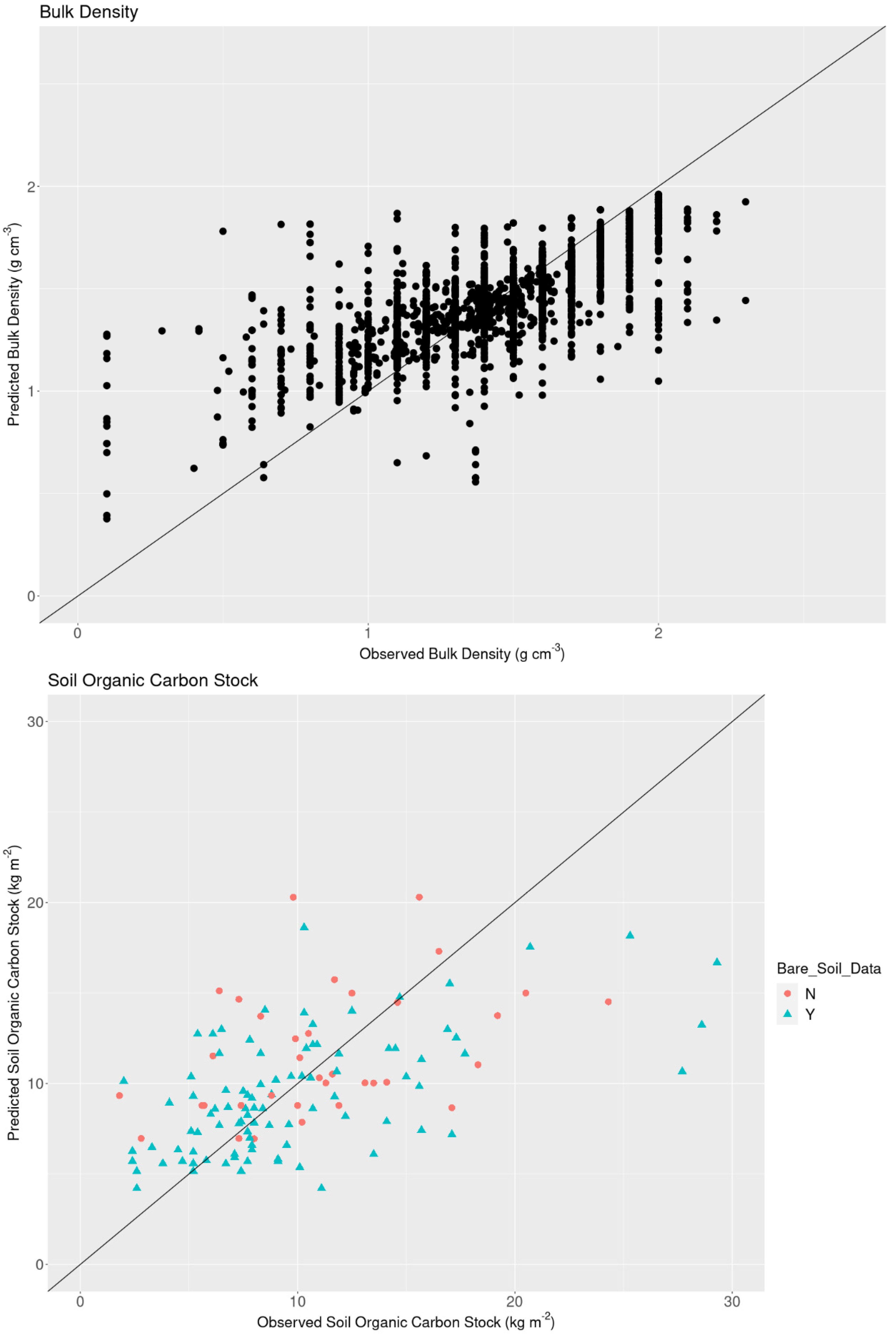
- Soil organic carbon stock
2.8. Model Validation
3. Results
4. Discussion
5. Conclusions
Supplementary Materials
Author Contributions
Funding
Data Availability Statement
Conflicts of Interest
References
- Bedard-Haughn, A.; Van Rees, K.; Bentham, M.; Krug, P.; Kiss, J.; Walters, K.; Heung, B.; Jamsrandorj, T.; Deters, R.; Cerkowniak, D.; et al. Saskatchewan Soil Information System (SKSIS) The Launch! Available online: https://harvest.usask.ca/bitstream/handle/10388/8664/A.Bedard-Haughn%20et%20al.2018.pdf?sequence=1 (accessed on 3 February 2021).
- Carré, F.; McBratney, A.B.; Mayr, T.; Montanarella, L. Digital Soil Assessments: Beyond DSM. Geoderma 2007, 142, 69–79. [Google Scholar] [CrossRef]
- McBratney, A.B.; Mendonça Santos, M.L.; Minasny, B. On Digital Soil Mapping. Geoderma 2003, 117, 3–52. [Google Scholar] [CrossRef]
- Gorelick, N.; Hancher, M.; Dixon, M.; Ilyushchenko, S.; Thau, D.; Moore, R. Google Earth Engine: Planetary-Scale Geospatial Analysis for Everyone. Remote Sens. Environ. 2017, 202, 18–27. [Google Scholar] [CrossRef]
- Maynard, J.J.; Levi, M.R. Hyper-Temporal Remote Sensing for Digital Soil Mapping: Characterizing Soil-Vegetation Response to Climatic Variability. Geoderma 2017, 285, 94–109. [Google Scholar] [CrossRef]
- Guo, L.; Fu, P.; Shi, T.; Chen, Y.; Zhang, H.; Meng, R.; Wang, S. Mapping Field-Scale Soil Organic Carbon with Unmanned Aircraft System-Acquired Time Series Multispectral Images. Soil Tillage Res. 2020, 196, 104477. [Google Scholar] [CrossRef]
- Fathololoumi, S.; Vaezi, A.R.; Alavipanah, S.K.; Ghorbani, A.; Saurette, D.; Biswas, A. Improved Digital Soil Mapping with Multitemporal Remotely Sensed Satellite Data Fusion: A Case Study in Iran. Sci. Total Environ. 2020, 721, 137703. [Google Scholar] [CrossRef]
- Demattê, J.A.M.; Fongaro, C.T.; Rizzo, R.; Safanelli, J.L. Geospatial Soil Sensing System (GEOS3): A Powerful Data Mining Procedure to Retrieve Soil Spectral Reflectance from Satellite Images. Remote Sens. Environ. 2018, 212, 161–175. [Google Scholar] [CrossRef]
- Bartholomeus, H.; Epema, G.; Schaepman, M. Determining Iron Content in Mediterranean Soils in Partly Vegetated Areas, Using Spectral Reflectance and Imaging Spectroscopy. Int. J. Appl. Earth Obs. Geoinf. 2007, 9, 194–203. [Google Scholar] [CrossRef]
- Bartholomeus, H.M.M.; Schaepman, M.E.E.; Kooistra, L.; Stevens, A.; Hoogmoed, W.B.B.; Spaargaren, O.S.P. Spectral Reflectance Based Indices for Soil Organic Carbon Quantification. Geoderma 2008, 145, 28–36. [Google Scholar] [CrossRef]
- Statistics Canada. 2016 Census of Agriculture. Available online: https://www.statcan.gc.ca/eng/ca2016 (accessed on 27 August 2020).
- Sorenson, P.T.; Shirtliffe, S.J.; Bedard-Haughn, A.K. Predictive Soil Mapping Using Historic Bare Soil Composite Imagery and Legacy Soil Survey Data. Geoderma 2021, 401, 115316. [Google Scholar] [CrossRef]
- Rogge, D.; Bauer, A.; Zeidler, J.; Mueller, A.; Esch, T.; Heiden, U. Building an Exposed Soil Composite Processor (SCMaP) for Mapping Spatial and Temporal Characteristics of Soils with Landsat Imagery (1984–2014). Remote Sens. Environ. 2018, 205, 1–17. [Google Scholar] [CrossRef]
- Safanelli, J.L.; Chabrillat, S.; Ben-Dor, E.; Demattê, J.A.M. Multispectral Models from Bare Soil Composites for Mapping Topsoil Properties over Europe. Remote Sens. 2020, 12, 1369. [Google Scholar] [CrossRef]
- Demattê, J.A.M.; Safanelli, J.L.; Poppiel, R.R.; Rizzo, R.; Silvero, N.E.Q.; de Sousa Mendes, W.; Bonfatti, B.R.; Dotto, A.C.; Salazar, D.F.U.; Alcântara de Oliveira Mello, F.; et al. Bare Earth’s Surface Spectra as a Proxy for Soil Resource Monitoring. Sci. Rep. 2020, 10, 4461. [Google Scholar] [CrossRef]
- Hengl, T.; Macmillan, R.A. Predictive Soil Mapping with R; Open Geo Hub Foundation: Wageningen, The Netherlands, 2019; ISBN 978-0-359-30635-0. [Google Scholar]
- Hengl, T.; Mendes de Jesus, J.; Heuvelink, G.B.M.; Ruiperez Gonzalez, M.; Kilibarda, M.; Blagotić, A.; Shangguan, W.; Wright, M.N.; Geng, X.; Bauer-Marschallinger, B.; et al. SoilGrids250m: Global Gridded Soil Information Based on Machine Learning. PLoS ONE 2017, 12, e0169748. [Google Scholar] [CrossRef]
- Sanderman, J.; Hengl, T.; Fiske, G.; Solvik, K.; Adame, M.F.; Benson, L.; Bukoski, J.J.; Carnell, P.; Cifuentes-Jara, M.; Donato, D.; et al. A Global Map of Mangrove Forest Soil Carbon at 30 m Spatial Resolution. Environ. Res. Lett. 2018, 13, 055022. [Google Scholar] [CrossRef]
- Viscarra Rossel, R.A.; Chen, C.; Grundy, M.J.; Searle, R.; Clifford, D.; Campbell, P.H. The Australian Three-Dimensional Soil Grid: Australia’s Contribution to the GlobalSoilMap Project. Soil Res. 2015, 53, 845. [Google Scholar] [CrossRef]
- Sothe, C.; Gonsamo, A.; Arabian, J.; Snider, J. Large Scale Mapping of Soil Organic Carbon Concentration with 3D Machine Learning and Satellite Observations. Geoderma 2022, 405, 115402. [Google Scholar] [CrossRef]
- Agriculture and Agri-Food Canada. Annual Crop Inventory. Available online: https://open.canada.ca/data/en/dataset/ba2645d5-4458-414d-b196-6303ac06c1c9 (accessed on 31 January 2021).
- Agriculture and Agri-Food Canada. National Pedon Database. Available online: https://open.canada.ca/data/en/dataset/6457fad6-b6f5-47a3-9bd1-ad14aea4b9e0 (accessed on 16 February 2021).
- Soil Classification Working Group the Canadian System of Soil Classification. The Canadian System of Soil Classification, 3rd ed.; Agriculture and Agri-Food Canada: Ottawa, ON, Canada, 1998; Volume 187. [Google Scholar]
- IUSS Working Group WRB. World Reference Base for Soil Resources 2014: International Soil Classification System for Naming Soils and Creating Legends for Soil Maps; Food and Agriculture Organization of the United Nations (FAO): Rome, Italy, 2014; ISBN 9789251083697. [Google Scholar]
- Baillie, I.C. Soil Survey Staff 1999, Soil Taxonomy: A Basic System of Soil Classification for Making and Interpreting Soil Surveys; Agricultural Handbook 436; Natural Resources Conservation Service (USDA): Washington, DC, USA, 1999. [Google Scholar]
- Wright, M.N.; Ziegler, A. Ranger: A Fast Implementation of Random Forests for High Dimensional Data in C++ and R. J. Stat. Softw. 2017, 77, 1–17. [Google Scholar] [CrossRef]
- Gitelson, A.A.; Merzlyak, M.N.; Chivkunova, O.B. Optical Properties and Nondestructive Estimation of Anthocyanin Content in Plant Leaves. Photochem. Photobiol. 2001, 74, 38. [Google Scholar] [CrossRef]
- Scudiero, E.; Skaggs, T.H.; Corwin, D.L. Regional-Scale Soil Salinity Assessment Using Landsat ETM + Canopy Reflectance. Remote Sens. Environ. 2015, 169, 335–343. [Google Scholar] [CrossRef]
- Sorenson, P. Google Earth Engine Scripts for Generating Predictive Soil Mapping Environmental Covariates. Available online: https://github.com/prestonsorenson/Google_Earth_Engine_PSM/tree/main (accessed on 16 August 2021).
- Copernicus Climate Change Service (C3S). ERA5: Fifth Generation of ECMWF Atmospheric Reanalyses of the Global Climate. Available online: https://cds.climate.copernicus.eu/cdsapp#!/home (accessed on 14 October 2021).
- Du, Y.; Zhang, Y.; Ling, F.; Wang, Q.; Li, W.; Li, X. Water Bodies’ Mapping from Sentinel-2 Imagery with Modified Normalized Difference Water Index at 10-m Spatial Resolution Produced by Sharpening the SWIR Band. Remote Sens. 2016, 8, 354. [Google Scholar] [CrossRef]
- Kokaly, R.F.; Clark, R.N.; Swayze, G.A.; Livo, K.E.; Hoefen, T.M.; Pearson, N.C.; Wise, R.A.; Benzel, W.M.; Lowers, H.A.; Driscoll, R.L.; et al. USGS Spectral Library Version 7; United States Geological Survey (USGS): Reston, VA, USA, 2017; Volume 7. [Google Scholar]
- Sorenson, P. Landsat 5 Bare Soil Composite Script. Available online: https://github.com/prestonsorenson/GEE_Bare_Soil_Composite/blob/main/Bare_Soil_Composite_Landsat_5 (accessed on 30 April 2021).
- Japan Aerospace Exploration Agency. ALOS Global Digital Surface Model. Available online: https://www.eorc.jaxa.jp/ALOS/en/aw3d30/index.htm (accessed on 24 September 2021).
- Boehner, J.; Selige, T. Spatial Prediction of Soil Attributes Using Terrain Analysis and Climate Regionalisation. In SAGA—Analyses and Modelling Applications; Boehner, J., McCloy, K.R., Strobl, J., Eds.; Göttinger Geographische Abhandlungen; Geographical Institute of the University of Göttingen: Göttingen, Germany, 2006; pp. 13–27. [Google Scholar]
- Kiss, J. Predictive Mapping of Wetland Types and Associated Soils through Digital Elevation Model Analyses in the Canadian Prairie Pothole Region. M.Sc. Thesis, University of Saskatchewan, Saskatoon, SK, Canada, 2018. [Google Scholar]
- Roudier, P. Clhs: A R Package for Conditioned Latin Hypercube Sampling 2011. Available online: https://github.com/pierreroudier/clhs/ (accessed on 14 November 2021).
- Biswas, A.; Zhang, Y. Sampling Designs for Validating Digital Soil Maps: A Review. Pedosphere 2018, 28, 1–15. [Google Scholar] [CrossRef]
- Sorenson, P. Predictive Soil Mapping Scripts. Available online: https://github.com/prestonsorenson/Predictive_Soil_Mapping (accessed on 28 October 2021).
- Kasraei, B.; Heung, B.; Saurette, D.D.; Schmidt, M.G.; Bulmer, C.E.; Bethel, W. Quantile Regression as a Generic Approach for Estimating Uncertainty of Digital Soil Maps Produced from Machine-Learning. Environ. Model. Softw. 2021, 144, 105139. [Google Scholar] [CrossRef]
- Vaysse, K.; Lagacherie, P. Evaluating Digital Soil Mapping Approaches for Mapping GlobalSoilMap Soil Properties from Legacy Data in Languedoc-Roussillon (France). Geoderma Reg. 2015, 4, 20–30. [Google Scholar] [CrossRef]
- Rizzo, R.; Medeiros, L.G.; de Mello, D.C.; Marques, K.P.P.; de Mendes, W.S.; Quiñonez Silvero, N.E.; Dotto, A.C.; Bonfatti, B.R.; Demattê, J.A.M. Multi-Temporal Bare Surface Image Associated with Transfer Functions to Support Soil Classification and Mapping in Southeastern Brazil. Geoderma 2020, 361, 114018. [Google Scholar] [CrossRef]
- Wang, S.; Zhuang, Q.; Wang, Q.; Jin, X.; Han, C. Mapping Stocks of Soil Organic Carbon and Soil Total Nitrogen in Liaoning Province of China. Geoderma 2017, 305, 250–263. [Google Scholar] [CrossRef]
- Wang, B.; Waters, C.; Orgill, S.; Gray, J.; Cowie, A.; Clark, A.; Liu, D.L. High Resolution Mapping of Soil Organic Carbon Stocks Using Remote Sensing Variables in the Semi-Arid Rangelands of Eastern Australia. Sci. Total Environ. 2018, 630, 367–378. [Google Scholar] [CrossRef]
- Liddicoat, C.; Maschmedt, D.; Clifford, D.; Searle, R.; Herrmann, T.; MacDonald, L.M.; Baldock, J. Predictive Mapping of Soil Organic Carbon Stocks in South Australia’s Agricultural Zone. Soil Res. 2015, 53, 956–973. [Google Scholar] [CrossRef]
- Nussbaum, M.; Spiess, K.; Baltensweiler, A.; Grob, U.; Keller, A.; Greiner, L.; Schaepman, M.E.; Papritz, A. Evaluation of Digital Soil Mapping Approaches with Large Sets of Environmental Covariates. Soil 2018, 4, 1–22. [Google Scholar] [CrossRef]
- Poppiel, R.R.; Demattê, J.A.M.; Rosin, N.A.; Campos, L.R.; Tayebi, M.; Bonfatti, B.R.; Ayoubi, S.; Tajik, S.; Afshar, F.A.; Jafari, A.; et al. High Resolution Middle Eastern Soil Attributes Mapping via Open Data and Cloud Computing. Geoderma 2021, 385, 114890. [Google Scholar] [CrossRef]
- Rossel, R.A.V.; Behrens, T.; Viscarra Rossel, R.A.; Behrens, T. Using Data Mining to Model and Interpret Soil Diffuse Reflectance Spectra. Geoderma 2010, 158, 46–54. [Google Scholar] [CrossRef]
- Nabiollahi, K.; Taghizadeh-Mehrjardi, R.; Shahabi, A.; Heung, B.; Amirian-Chakan, A.; Davari, M.; Scholten, T. Assessing Agricultural Salt-Affected Land Using Digital Soil Mapping and Hybridized Random Forests. Geoderma 2021, 385, 114858. [Google Scholar] [CrossRef]
- Taghizadeh-Mehrjardi, R.; Schmidt, K.; Toomanian, N.; Heung, B.; Behrens, T.; Mosavi, A.; Band, S.; Amirian-Chakan, A.; Fathabadi, A.; Scholten, T. Improving the Spatial Prediction of Soil Salinity in Arid Regions Using Wavelet Transformation and Support Vector Regression Models. Geoderma 2021, 383, 114793. [Google Scholar] [CrossRef]
- Ma, G.; Ding, J.; Han, L.; Zhang, Z.; Ran, S. Digital Mapping of Soil Salinization Based on Sentinel-1 and Sentinel-2 Data Combined with Machine Learning Algorithms. Reg. Sustain. 2021, 2, 177–188. [Google Scholar] [CrossRef]
- Kiss, J.; Bedard-Haughn, A. Predictive Mapping of Solute-rich Wetlands in the Canadian Prairie Pothole Region Through High-resolution Digital Elevation Model Analyses. Wetlands 2021, 41, 38. [Google Scholar] [CrossRef]
- Jenny, H. Factors of Soil Formation. Soil Sci. 1941, 52, 415. [Google Scholar] [CrossRef]
- Becker, W.R.; Ló, T.B.; Johann, J.A.; Mercante, E. Statistical Features for Land Use and Land Cover Classification in Google Earth Engine. Remote Sens. Appl. 2021, 21, 100459. [Google Scholar] [CrossRef]
- Gilabert, M.A.; González-Piqueras, J.; García-Haro, F.J.; Meliá, J. A Generalized Soil-Adjusted Vegetation Index. Remote Sens. Environ. 2002, 82, 303–310. [Google Scholar] [CrossRef]
- Miao, Y.; Mulla, D.J.; Robert, P.C. Identifying Important Factors Influencing Corn Yield and Grain Quality Variability Using Artificial Neural Networks. Precis. Agric. 2006, 7, 117–135. [Google Scholar] [CrossRef]
- He, Y.; Wei, Y.; DePauw, R.; Qian, B.; Lemke, R.; Singh, A.; Cuthbert, R.; McConkey, B.; Wang, H. Spring Wheat Yield in the Semiarid Canadian Prairies: Effects of Precipitation Timing and Soil Texture over Recent 30 Years. Field Crops Res. 2013, 149, 329–337. [Google Scholar] [CrossRef]


| Canadian System of Soil Science Classification | World Reference Base | United States Department of Agriculture Soil Classification System | n |
|---|---|---|---|
| Brunisol | Cambisol | Inceptisol | 3 |
| Chernozem | Kastanozem, Chernozem, Greyzem, Phaeozem | Borolls | 398 |
| Gleysol | Gleysol | Aqu suborders | 7 |
| Luvisol | Luvisol | Boralfs, Udalfs | 66 |
| Regosol | Regosol | Entisol | 25 |
| Solonetz | Solonetz | Natric Great Groups | 73 |
| Vertisol | Vertisol | Haplocryerts | 5 |
| Soil Property | Horizon | Null Model Root Mean Square Error | Predictive Model R2 | Predictive Model Root Mean Square Error | Predictive Model Concordance Correlation Coefficient | S |
|---|---|---|---|---|---|---|
| Soil Organic Carbon (%) | Overall | 1.14 | 0.71 | 0.61 | 0.83 | −0.07 |
| A | 1.39 | 0.49 | 0.85 | 0.64 | −0.11 | |
| B | 0.77 | 0.21 | 0.40 | 0.39 | −0.06 | |
| C | 1.09 | 0.11 | 0.31 | 0.25 | −0.01 | |
| Total Nitrogen (%) | Overall | 0.10 | 0.65 | 0.06 | 0.76 | 0.00 |
| A | 0.12 | 0.48 | 0.07 | 0.60 | 0.01 | |
| B | 0.07 | 0.25 | 0.05 | 0.39 | 0.00 | |
| C | 0.09 | 0.36 | 0.04 | 0.44 | 0.00 | |
| Inorganic Carbon (%) | Overall | 8.09 | 0.65 | 4.79 | 0.79 | −0.25 |
| A | 5.66 | 0.11 | 3.07 | 0.29 | −0.75 | |
| B | 7.08 | 0.16 | 5.67 | 0.25 | −0.10 | |
| C | 10.88 | 0.56 | 5.42 | 0.73 | 0.18 | |
| Electrical Conductivity (dS m−1) | Overall | 2.50 | 0.36 | 2.18 | 0.57 | −0.61 |
| A | 1.94 | 0.08 | 1.67 | 0.23 | −0.28 | |
| B | 1.94 | 0.26 | 1.67 | 0.47 | −0.50 | |
| C | 3.40 | 0.34 | 3.00 | 0.53 | −1.09 | |
| Cation Exchange Capacity (meq 100 g−1) | Overall | 11.27 | 0.46 | 8.18 | 0.63 | −0.42 |
| A | 12.09 | 0.47 | 8.80 | 0.63 | −0.61 | |
| B | 10.12 | 0.41 | 7.81 | 0.61 | −0.22 | |
| C | 11.37 | 0.36 | 7.81 | 0.51 | −0.40 | |
| Clay (%) | Overall | 15.62 | 0.55 | 10.47 | 0.70 | −0.47 |
| A | 14.36 | 0.65 | 8.23 | 0.76 | −1.05 | |
| B | 15.77 | 0.50 | 11.10 | 0.67 | 0.43 | |
| C | 16.81 | 0.49 | 12.00 | 0.66 | −0.68 | |
| Sand (%) | Overall | 22.55 | 0.44 | 16.99 | 0.64 | −0.61 |
| A | 21.46 | 0.52 | 14.89 | 0.70 | 0.57 | |
| B | 22.45 | 0.44 | 17.03 | 0.64 | −1.84 | |
| C | 23.82 | 0.37 | 19.07 | 0.58 | −0.74 | |
| Horizon Thickness (%) | Overall | 0.55 | 0.76 | 0.27 | 0.86 | 0.00 |
| A | 0.38 | 0.06 | 0.10 | 0.21 | −0.03 | |
| B | 0.30 | 0.06 | 0.23 | 0.21 | −0.01 | |
| C | 0.80 | 0.66 | 0.39 | 0.79 | 0.03 | |
| Bulk Density (g cm−3) | Overall | 0.3 | 0.52 | 0.20 | 0.66 | <0.01 |
| Soil Organic Carbon Stock (kg m−2) | Overall | 5.83 | 0.27 | 4.84 | 0.47 | 0.31 |
| Soil Property | Features | Relative Feature Importance |
|---|---|---|
| Soil Organic Carbon (%) | Horizon | 0.46 |
| ARI No Bare Soil Pixels | 0.15 | |
| Standard Deviation of NDVI | 0.09 | |
| September and October NDVI | 0.08 | |
| Precipitation | 0.08 | |
| Temperature | 0.07 | |
| Bare Soil Band 7 | 0.07 | |
| Bulk Density (g cm−3) | Soil Organic Carbon | 0.26 |
| Sand Content | 0.26 | |
| Silt Content | 0.25 | |
| Clay Content | 0.24 | |
| Profile Soil Organic Carbon Stocks (kg m2) | Standard Deviation of NDVI | 0.18 |
| Precipitation | 0.14 | |
| Temperature | 0.14 | |
| September and October NDVI | 0.13 | |
| CRSI No Bare Soil Pixels | 0.12 | |
| CRSI | 0.12 | |
| Bare Soil Band 2 | 0.11 | |
| SAGA Wetness Index | 0.05 | |
| Total Nitrogen (%) | Horizon | 0.52 |
| Bare Soil Band 7 | 0.09 | |
| September and October NDVI | 0.08 | |
| Standard Deviation of NDVI | 0.08 | |
| Temperature | 0.08 | |
| Precipitation | 0.07 | |
| CRSI No Bare Soil Pixels | 0.07 | |
| Cation Exchange Capacity (meq 100 g−1) | Standard Deviation of NDVI | 0.17 |
| Bare Soil Band 5 | 0.17 | |
| Horizon | 0.17 | |
| July and August SAVI No Bare Soil Pixels | 0.16 | |
| Temperature | 0.14 | |
| Precipitation | 0.13 | |
| Standard Deviation of Elevation (101 × 101 focal window with 9 × 9 median focal filter of the input surface model) | 0.06 | |
| Electrical Conductivity (dS m−1) | Horizon | 0.18 |
| Temperature | 0.16 | |
| September and October NDVI | 0.15 | |
| CRSI | 0.14 | |
| Precipitation | 0.12 | |
| Bare Soil Band 5 | 0.12 | |
| Standard Deviation of Elevation (21 × 21 focal window with 3 × 3 median focal filter of the input surface model) | 0.07 | |
| Standard Deviation of Elevation (3 × 3 focal window with 3 × 3 median focal filter of the input surface model) | 0.06 | |
| Inorganic Carbon (%) | Horizon | 0.49 |
| Precipitation | 0.21 | |
| Temperature | 0.11 | |
| ARI No Bare Soil Pixels | 0.10 | |
| July and August NDVI | 0.09 | |
| Clay (%) | Bare Soil Band 5 | 0.20 |
| Standard Deviation of NDVI | 0.18 | |
| September and October NDVI | 0.17 | |
| Temperature | 0.13 | |
| Precipitation | 0.13 | |
| CRSI No Bare Soil Pixels | 0.13 | |
| Horizon | 0.05 | |
| Sand (%) | Standard Deviation of NDVI | 0.20 |
| September and October of NDVI | 0.17 | |
| Bare Soil Band 7 | 0.15 | |
| Temperature | 0.14 | |
| ARI No Bare Soil Pixels | 0.13 | |
| Precipitation | 0.06 | |
| Standardized Height | 0.06 | |
| Horizon | 0.02 | |
| Horizon Thickness | Horizon | 0.48 |
| Precipitation | 0.14 | |
| Temperature | 0.13 | |
| ARI | 0.07 | |
| Standard Deviation of NDVI | 0.07 | |
| Bare Soil Band 7 | 0.06 | |
| Standard Deviation of Elevation (3 × 3 focal window with 3 × 3 median focal filter of the input surface model) | 0.04 |
Publisher’s Note: MDPI stays neutral with regard to jurisdictional claims in published maps and institutional affiliations. |
© 2022 by the authors. Licensee MDPI, Basel, Switzerland. This article is an open access article distributed under the terms and conditions of the Creative Commons Attribution (CC BY) license (https://creativecommons.org/licenses/by/4.0/).
Share and Cite
Sorenson, P.T.; Kiss, J.; Bedard-Haughn, A.K.; Shirtliffe, S. Multi-Horizon Predictive Soil Mapping of Historical Soil Properties Using Remote Sensing Imagery. Remote Sens. 2022, 14, 5803. https://doi.org/10.3390/rs14225803
Sorenson PT, Kiss J, Bedard-Haughn AK, Shirtliffe S. Multi-Horizon Predictive Soil Mapping of Historical Soil Properties Using Remote Sensing Imagery. Remote Sensing. 2022; 14(22):5803. https://doi.org/10.3390/rs14225803
Chicago/Turabian StyleSorenson, Preston T., Jeremy Kiss, Angela K. Bedard-Haughn, and Steve Shirtliffe. 2022. "Multi-Horizon Predictive Soil Mapping of Historical Soil Properties Using Remote Sensing Imagery" Remote Sensing 14, no. 22: 5803. https://doi.org/10.3390/rs14225803
APA StyleSorenson, P. T., Kiss, J., Bedard-Haughn, A. K., & Shirtliffe, S. (2022). Multi-Horizon Predictive Soil Mapping of Historical Soil Properties Using Remote Sensing Imagery. Remote Sensing, 14(22), 5803. https://doi.org/10.3390/rs14225803