Article

Characteristics and Driving Mechanism of Regional Ecosystem Assets Change in the Process of Rapid Urbanization—A Case Study of the Beijing–Tianjin–Hebei Urban Agglomeration

State Key Laboratory of Urban and Regional Ecology, Research Center for Eco-Environmental Sciences, Chinese Academy of Sciences, Beijing 100085, China
*
Author to whom correspondence should be addressed.
Remote Sens. 2022, 14(22), 5747; https://doi.org/10.3390/rs14225747
Submission received: 21 October 2022 / Revised: 5 November 2022 / Accepted: 10 November 2022 / Published: 14 November 2022
(This article belongs to the Special Issue Remote Sensing for Land System Mapping and Monitoring)

Abstract

:
Land urbanization has reduced the amount of area for natural ecosystem assets. However, with the development of the social economy, will the quality of natural ecosystem assets be improved? If one comprehensively considers the changes in the area and quality of natural ecosystem assets, is the dominant impact of urbanization on natural ecosystem assets positive or negative? In this study, detailed research is conducted on the area, pattern, quality, and overall situation of the ecosystem assets in the Beijing–Tianjin–Hebei urban agglomeration during the rapid urbanization process. The impact of urbanization on the overall situation of ecosystem assets is also analyzed. The research methods used to generate statistics, accounting, and analysis of the ecosystem assets include ArcGIS, satellite remote sensing images, R language programming, and other data analysis tools. The research results show that: (1) The ecosystem area was dominated by degradation, and the landscape pattern became increasingly fragmented, with the exception of farmland and wetland areas. (2) However, the quality of the natural ecosystem assets was significantly improved, and the overall situation of the natural ecosystem assets was optimized. (3) In addition to the population urbanization rate, the growth in the population density, land urbanization rate, and GDP per unit area had a significant negative impact on the overall situation of natural ecosystem assets. This reminds people that the improvement in asset quality can compensate for the reduction in area to some extent, and, in addition to the population urbanization rate, the levels of population density, land urbanization, and economic density should be appropriately controlled.

Graphical Abstract

1. Introduction

Ecosystem assets (EAs) are contiguous spaces of a specific ecosystem type, characterized by a distinct set of biotic and abiotic components and their interactions. The definition of ecosystem assets is a statistical representation of the general definition of ecosystems from the Convention on Biological Diversity [1,2], including forests, wetlands, agricultural areas, rivers, and coral reefs [1]. This is basically consistent with the concept of ecological assets, which is widely used in the research of Chinese scholars [3,4,5,6,7]. The earliest concept related to ecosystem assets in the world is natural capital [8], including renewable and non-renewable natural resources (such as plants, animals, air, water, soils, energy, and minerals) [1,9,10]. Ecosystem assets are an important part of natural capital [11] and are the material basis of ecosystem service functions and ecosystem service values, which are directly related to the well-being of human society and can be measured by area and quality [2,12]. In fact, as early as 1907, people had realized that natural capital should be increased as an asset for social and economic development [13].
Ecosystem assets can be measured using both physical and monetary units [14,15], and the choice depends on the research objective. This study focuses on the physical condition; the most common indicators thereof used in existing research include area and vegetation indices, such as the enhanced vegetation index (EVI), normalized difference water index (NDWI), and net primary productivity (NPP) [16]. However, the above indicators cannot express the overall situation of the area and quality of the ecosystem assets. The ecosystem asset index solves this problem [17,18]. This study conducts a comprehensive examination of the area, quality, and ecosystem asset index. It should be noted that both the area and quality of ecosystem assets face various problems and risks. One of the most important influencing factors is urbanization. Although there have been many studies on the impact of urbanization on the pattern, area, and quality of ecosystem assets, and there have also been some recent studies on ecosystem asset index accounting [7,17,18], few studies have focused on the impact of urbanization on the ecosystem asset index. The research on the relationship between urbanization and the ecosystem asset index helps explore how to maintain or even increase ecosystem assets when the area of ecosystem decreases due to urbanization. This study comprehensively considers the changes in ecosystem assets resulting from urbanization in four respects: ecosystem area, pattern, quality, and ecosystem asset index.
Most of the research results on the impact of urbanization on the area of an ecosystem show that the rapid expansion of urban land occupies a large amount of ecosystem land [19,20,21]. However, the research results on the effect of urbanization on the quality of ecosystem assets are more complex: urbanization may have significant negative impacts [22,23,24], as well as positive effects [25]. If the impact of urbanization on the area and quality of an ecosystem is considered at the same time, urbanization may have a significant negative impact on both the area and quality [26,27,28], but the area of certain types of ecosystem assets might shrink while the quality improves, and the comprehensive ecosystem asset index could increase in the process of urbanization [18]. Therefore, the research on the impact of urbanization on ecosystem assets should focus on specific issues and fully consider the impact of urbanization on the area, quality, and overall situation of an ecosystem. It can be seen from this that urbanization is a great challenge to the protection of ecosystem assets, but that it may also be an opportunity. This is because, on the one hand, the expansion of urban land will occupy the area of an ecosystem, and the increase in population density and the advancement of industrialization will enhance the interference of human activities with the quality of ecosystem assets; however, on the other hand, the strengthening of ecological protection and restoration in the process of urbanization will help to improve the quality of ecosystem assets [29]. This makes it difficult to predict the comprehensive results of the changes in the area and quality of ecosystem assets in the process of urbanization; therefore, research on the ecosystem asset index is essential.
Research on changes in ecosystem assets is essential primarily because it relates to the sustainable development of urbanization. This is because, in the process of urbanization, the relationship between urban areas and their surrounding regions is mutually influential and interdependent. Urban development requires the supply support of regional resources and energy [30], and regional development is inseparable from the capital investment and technical support of cities. Once urbanization exceeds the carrying capacity of the regional ecological environment, resulting in the absence, degradation, or environmental pollution of regional ecosystem assets, it will be difficult to continue to provide resource support for urban development, which will eventually severely restrict urban development [31]. Moreover, the destruction of regional ecosystem assets will weaken the ecosystem service function, leading to the enhancement of the urban heat island effect, air pollution, water shortage, biodiversity loss, the greenhouse effect, climate change, and other negative ecological environment effects that directly affect the quality of human living environments [32,33,34,35]. Therefore, once the urban socioeconomic development reaches or exceeds the environmental and resource carrying capacity, the city must discard some of its functions and further optimize its spatial structure to overcome these problems [36]. This makes research on the changes in regional ecosystem assets in the process of urbanization particularly important.
From 2000 to 2015, the urbanization rate of the world population increased from 47% to 54% [37], and that of China increased from 36% to 56% [38]. Compared with the rest of the world, China is in a stage of rapid urbanization. The United Nations predicts that, from 2018 to 2050, China will gain an additional 255 million urban residents [39] (p. 43), and the population urbanization rate is expected to reach 80% [40]. In 2020, China’s population urbanization rate was 63.89% [41]. This means that there will be significant pressure on China’s urbanization development in the future, and the pressure on resources and the environment will continue to increase. As one of the three largest urban agglomerations, with the largest population, the most dynamic economy, and the strongest innovation ability in China, the Beijing–Tianjin–Hebei urban agglomeration aims to be world-class to achieve its development goal [42], and its urbanization is of great importance. From 2000 to 2015, the population urbanization rate of the Beijing–Tianjin–Hebei urban agglomeration increased from 39.04% to 62.53%, which is much higher than that of the whole country [43]. This study takes the Beijing–Tianjin–Hebei urban agglomeration as a case study to study the characteristics and driving mechanism of regional ecosystem assets changes in the rapid urbanization stage and provides policy recommendations for the sustainable development of the Beijing–Tianjin–Hebei urban agglomeration.
Studies have shown that the ecosystem service function of the Beijing–Tianjin–Hebei urban agglomeration is significantly and positively related to the vegetation coverage, and is significantly disturbed by human activities [44]. Therefore, it is of great significance to study the quality of ecosystem assets and their driving mechanism. However, most of the existing studies on the changes in ecosystem assets in the Beijing–Tianjin–Hebei urban agglomeration only focus on the temporal and spatial changes in ecosystem area and do not involve the pattern, quality, and driving mechanisms of the ecosystem assets [45,46,47,48]. In addition, the inadequacies of these studies also include: shrub not being regarded as an independent ecosystem type but being incorporated into forest [45,46,47,48]; and the spatial resolution of land use/land cover data used in some studies being low, at only 100 m [45,48]. Some studies also focus on the changes in ecosystem patterns [49,50,51], and some even analyze their driving mechanisms [49,50]; however, these studies do not assess the quality of the ecosystem assets.
Several studies have also researched vegetation changes in the Beijing–Tianjin–Hebei urban agglomeration [52,53,54,55]. Many of these studies also analyze the driving mechanism of vegetation change, including the impact factors related to urbanization [52,53,54]. The indicators used to measure vegetation change in such studies are often single indicators such as the NDVI (Normalized Difference Vegetation Index), FVC (Fractional Vegetation Cover), EVI (Enhanced Vegetation Index) and vegetation coverage. Although such indicators can reflect the quality of ecosystem assets to a certain extent, they cannot replace it as a measure of impact. This is because, on the one hand, a single vegetation indicator study cannot distinguish different ecosystem types, so it cannot analyze the differences among ecosystem types. On the other hand, most of the quality classification represented by a single vegetation indicator are not precise enough. Moreover, such studies as mentioned above do not involve changes in the area and pattern of ecosystems. Some studies have established an eco-environmental quality index based on the expert scoring method to measure the ecological environment quality of different land use types. However, the evaluation object of this indicator also includes urban area, which is not an accurate indicator for evaluating the quality of ecosystem assets, and it is also unable to distinguish between ecosystem types [56]. Strictly speaking, only one study on the quality and driving forces of the ecosystem of the Beijing–Tianjin–Hebei urban agglomeration has been performed. This study analyzed the temporal and spatial changes in the asset quality of the forest, shrub, and grassland ecosystems in the Beijing–Tianjin–Hebei urban agglomeration from 2000 to 2010 and their natural and human-driven mechanisms. However, this study did not analyze changes in the area and pattern of the ecosystem assets, and the comprehensive indicators of area and quality were not considered [57].
At present, no research has comprehensively considered the changes in the area, pattern, and quality of the ecosystem assets of the Beijing–Tianjin–Hebei urban agglomeration, let alone comprehensively evaluated the area and quality of the ecosystem assets of the urban agglomeration and their relationship with urbanization. This study makes up for the paucity of related research on the Beijing–Tianjin–Hebei urban agglomeration. The purpose of this study is to comprehensively analyze the spatio-temporal change characteristics of the ecosystem assets of the urban agglomeration in regard to three aspects—the area, pattern and quality—so as to clarify the characteristics of the impact of land urbanization on the area and quality of the ecosystem assets throughout the rapid urbanization process that took place from 2000 to 2015, and to calculate the ecosystem asset index of the natural ecosystem assets of the Beijing–Tianjin–Hebei urban agglomeration at the county level and the urban agglomeration level. In doing so, the study attempts to more accurately judge the spatial distribution and change in natural ecosystem assets, so as to clarify whether the quality is significant for the protection and recovery of natural ecosystem assets, and to analyze their urbanization driving mechanisms, so as to provide effective policy recommendations for the harmonious and sustainable development of urbanization.
Accordingly, the structure of this study is organized as follows: Section 2 focuses on the materials and methodology used in the study, followed by Section 3, where we provide the research results, including Section 3.1, which presents the changes in the ecosystem assets, and Section 3.2, which presents the urbanization impact mechanisms. Section 3.1 analyzes the ecosystem asset changes in terms of area and composition, distribution and transfer, pattern change, quality change, and asset index change, while Section 3.2 introduces the background of urbanization and analyzes the urbanization impact mechanisms of the natural ecosystem assets from four aspects: population urbanization, population density, GDP per unit area, and land urbanization. Then, Section 4 discusses the main research results, and, finally, Section 5 summarizes the main conclusions of this study.

2. Materials and Methods

2.1. Study Area

The Beijing–Tianjin–Hebei urban agglomeration is located in Bohai Bay in northern China, between 113°27′–119°50′E and 36°05′–42°05′N, bordering the Mongolian Plateau in the north, the Huang Huai Plain in the south, the Taihang Mountains in the west, and the Bohai Sea in the east. The total area of the region is 216,000 km2, accounting for 2.2% of the total land area of the country [58,59]. The altitude of the study area increases from southeast to northwest, and the landform transitions from plain to mountain. The southeast is plain, comprising piedmont plain, middle-low plain, and coastal plain; the northwest is a mountainous area composed of plateaus, mountains, and hills. The study area belongs to a typical temperate semi-humid and semi-arid continental monsoon climate, and the precipitation is mainly concentrated in the summer, with the same period of rain and heat [60]. The study area includes two municipalities directly under the central government, Beijing and Tianjin, and 11 prefecture-level cities in Hebei Province: Shijiazhuang, Tangshan, Qinhuangdao, Handan, Xingtai, Baoding, Zhangjiakou, Chengde, Cangzhou, Langfang, and Hengshui. The study area also includes 202 districts and counties. The Beijing–Tianjin–Hebei urban agglomeration is the largest economy in northern China and one of the three core economic regions in China. In 2020, the total GDP of the Beijing–Tianjin–Hebei urban agglomeration was 8639.318 billion yuan, accounting for 8.52% of the national GDP; the total resident population was 110.3693 million, accounting for 7.82% of the total population of the country. Beijing and Tianjin are megacities with an urban population of more than 10 million (Figure 1) [61].

2.2. Data Source

The land cover data set of the study in 2000 and 2015 is from the China Ecosystem Assessment and Ecological Security Database: https://www.ecosystem.csdb.cn/ecogj/index.jsp [62], which accessed on 1 June 2021. The Digital Elevation Model is 30 m × 30 m, which comes from the Advanced Spaceborne Thermal Emission and Reflection Radiometer (ASTER) Global Digital Elevation Model Version 3 (GDEM 003) from the Geospatial Data Cloud: http://www.gscloud.cn [63], which accessed on 1 October 2022. The biomass data and vegetation coverage data come from the Remote Sensing Survey and Assessment Project of the National Ten Year Change of Ecological Environment (2000–2010) of the Chinese Academy of Sciences and the Ministry of Ecological Environment, and the Remote Sensing Survey and Assessment Project of the National Five Year Change of Ecological Environment (2010–2015). The data of total population, urban resident population, GDP, and district/county GDP deflator are from the relevant statistical yearbooks.

2.3. Methods

This study measures ecosystem assets in three respects: (1) area, composition, and pattern; (2) quality of ecosystem assets; (3) ecosystem asset index.

2.3.1. Spatio-Temporal Change in Ecosystem Area

In this study, ArcGIS is used to carry out spatial statistical analysis and mapping of the land use/land cover raster data of the Beijing–Tianjin–Hebei urban agglomeration. The statistical charts of the ecosystem area and composition in the study are obtained by statistical mapping in Excel based on the data obtained from ArcGIS. The map of ecosystem spatial distribution and change is directly mapped by ArcGIS. The schematic diagram of ecosystem type transfer from 2000 to 2015 (figure in Section 3.1.2) is based on the data obtained from ArcGIS statistics and is plotted using the networkD3 package in R [64].

2.3.2. Landscape Pattern Indices

The landscape fragmentation index was selected as a typical landscape pattern index to measure the landscape pattern change trend of the Beijing–Tianjin–Hebei urban agglomeration. The landscape fragmentation index can reflect the fragmentation degree of landscape segmentation [65].
The landscape fragmentation index is calculated by
F N 1 = N P 1 / N C
F N 2 = M P S × N F 1 / N C
where FN1 is the fragmentation index of the whole study area; FN2 is the fragmentation index of a certain landscape type; NP is the total number of landscape patches; NC is the ratio of the total area of the study area to the minimum patch area; MPS is the average patch area of a certain landscape type; and NF is the number of patches of a certain landscape type. FN1 and FN2 are both between 0 and 1; 0 means the landscape is not damaged at all, and 1 means the landscape is completely damaged [66].
In this study, the values of various indicators required for the calculation of the landscape fragmentation index were obtained through the landscapemetrics package, and then the required landscape pattern index was obtained by substituting them into Formulas (1) and (2). The landscapemetrics package is an R package for calculating landscape metrics for categorical landscape patterns via a tidy workflow [67]. The reason it was not possible to directly obtain the calculation results of the landscape fragmentation index in this study through the landscapemetrics package is that this R package does not provide a calculation service for the landscape fragmentation index.

2.3.3. Ecosystem Asset Quality

In this study, the quality of forest, shrub, and grassland ecosystem assets was calculated. Among them, the quality of ecosystem assets of forests and shrubs is evaluated by pixel-based relative biomass density. The specific methods are as follows:
E A Q i j = B i j C C B i × 100 %
where E A Q i j is the ecosystem asset quality of j pixel of class i ecosystem assets; B i j   is the biomass of j pixel of class i ecosystem assets; and C C B i is the biomass of the top community pixel of class i ecosystem assets. The criteria for determining the biomass of the top community are as follows: the biomass value ranks in the top 10%, and the fluctuation range is less than 5%. In this study, since the top 10% of biomass values do not intersect with biomass data with fluctuation amplitude less than 5%, the maximum value of biomass with fluctuation amplitude less than 5% is adopted. The final top community biomass of forest ecosystem assets is 9488 g/m2, and the top community biomass of shrub ecosystem assets is 7942 g/m2.
The quality of grassland ecosystem assets is evaluated by vegetation coverage, and the specific methods are as follows:
E A Q i j = C i j C C C i × 100 %
where E A Q i j is the ecosystem asset quality of j pixel of class i ecosystem assets; C i j is the vegetation coverage of j pixel of class i ecosystem assets; and C C C i is the vegetation coverage of the top community pixel of class i ecosystem assets.
The grading standards for the quality of forest, shrub, and grassland ecosystem assets are presented in Table 1.

2.3.4. Ecosystem Asset Indices

The ecosystem asset index can evaluate the comprehensive characteristics of the area and the quality of the ecosystem assets, which is more accurate than evaluating the area or quality alone. In this study, the ecosystem asset indices of forests, shrubs, and grasslands, as well as the comprehensive indices of the above three ecosystem assets, were calculated separately. The specific methods are as follows:
E Q i = j = 1 5 E A i j × j E A i × 5 × 100
E Q = i = 1 n j = 1 5 E A i j × j i = 1 n E A i × 5 × 100
where E Q i is the ith ecosystem asset index; E Q is the comprehensive ecosystem asset index; i is the ecosystem assets type, i = 1, 2, …, n; j is the ecosystem asset quality grade index, that is, excellent, good, medium, poor, and bad, j = 1, 2, 3, 4, 5; E A i j is the area of the ith type of ecosystem assets at the jth grade; and E A i is the area of the ith type of ecosystem assets.
The spatial distribution map of ecosystem asset indices adopts the natural breaks grading method, with small intra-class differences and large inter-class differences.

2.3.5. Urbanization Indicators

This study measures three aspects of the urbanization development level of the Beijing–Tianjin–Hebei urban agglomeration: population urbanization level, economic urbanization level, and land urbanization level. Among them, the population urbanization rate and population density are selected as the measurement indicators of the population urbanization level, the GDP per unit area is used as the measurement indicator of the economic urbanization level, and the land urbanization rate is selected as the measurement index of the land urbanization level. The calculation methods are as follows:
Population   urbanization   rate = Urban   permanent   population Total   population × 100 %
Population   density = Total   population Total   administrative   area
GDP   per   unit   area = Total   GDP Total   administrative   area × 100 %
The 2015 GDP values were inflation-adjusted to prices that can be compared with 2000 values by using the GDP deflator for each city, eliminating the error between the current price and the actual price.
Land   urbanization   rate = Urban   area Total   administrative   area × 100 %
The spatial distribution map of urbanization indicators adopts the quantile grading method.

2.3.6. Correlation between Urbanization and Ecosystem Assets Change

When analyzing the correlation between the changes in the various ecosystem assets indicators of the Beijing–Tianjin–Hebei urban agglomeration and the changes in various urbanization indicators from 2000 to 2015, since the original data did not conform to the normal distribution, this study selected the Spearman correlation analysis method. The Spearman correlation analysis results and the plotting of changes to relevant indicators in this study are obtained by relying on the corrplot package. The corrplot package is an R package that provides a visual exploratory tool on the correlation matrix that supports automatic variable reordering in order to help detect hidden patterns among variables, and it also provides p-values and confidence intervals to help users determine the statistical significance of correlations [68]. The abbreviations corresponding to each indicator are as follows: forest ecosystem asset index: FEAI; shrub ecosystem asset index: SEAI; grassland ecosystem asset index: GEAI; comprehensive ecosystem asset index: CEAI; population urbanization rate: PUR; population density: PD; GDP per unit area: GDPPUA; land urbanization rate: LUR. The original data for correlation analysis are the increment of the above indicators in 202 districts and counties of the urban agglomeration from 2000 to 2015.

3. Results

3.1. Changes in Ecosystem Assets

3.1.1. Ecosystem Area and Composition

The area of various ecosystems in the Beijing–Tianjin–Hebei urban agglomeration is shown in Figure 2. In 2000, the ecosystem types of the Beijing–Tianjin–Hebei urban agglomeration were ranked by area: farmland > forests > shrubs > grasslands > urban > wetlands > other lands. By 2015, the urban area had risen from the fifth position to the fourth.
In 2000 and 2015, the areas of various ecosystems in the Beijing–Tianjin–Hebei urban agglomeration were as shown in Figure 3. The proportion of farmland area has decreased, but the area of the farmland alone still accounts for more than 40% of the total area; the area of the other six types of ecosystems accounts for less than 60% in total, of which the area of the wetlands accounts for the smallest and is still decreasing. Aside from the farmland, it seems that only the wetlands have decreased in area and proportion, but attention should be paid to this issue, because wetlands can provide ecosystem services that cannot be provided by other ecosystems, meaning that wetlands hold great significance with regard to human social development and ecological environment security.
The area increment and change in various ecosystems in the Beijing–Tianjin–Hebei urban agglomeration from 2000 to 2015 are shown in Figure 4. The urban area increased the most and was 29.96% larger in 2015 than in 2000, while the area of farmland decreased the most, by 7103.72 km2, 1.33 times the area of the newly added urban area. The wetlands shrank 5.89% compared with 2000, and shrubs, grasslands, forests, and other lands increased in varying degrees from large to small. It can be seen that, from 2000 to 2015, the expansion speed of the urban area in the Beijing–Tianjin–Hebei urban agglomeration was extremely fast, while the farmland area decreased significantly. Such a rapid land urbanization development speed exemplifies the immediate importance and necessity of emphasizing the quality of urbanization development, and the urgency of formulating and implementing farmland protection policies and measures.

3.1.2. Ecosystem Distribution and Transfer

Ecosystems in the Beijing–Tianjin–Hebei urban agglomeration have obvious spatial differences. The forests, shrubs, and grasslands are mainly distributed in the Yanshan Mountains in the north and the Taihang Mountains in the west; the wetlands are mainly distributed in the Bohai Bay area, and the rest of the wetlands are scattered; the farmland is mainly distributed in the vast plain in the southeast; and the urban areas are mainly distributed in municipalities directly under the central government and prefecture-level cities. Among them, Beijing and Tianjin are the most concentrated and widely distributed (Figure 5A). Sorted in descending order of area, the spatial distribution of ecosystem change types that cumulatively account for the top 99% of the total ecosystem area changes from 2000 to 2015 is shown in Figure 5B. It can be seen that the newly added urban land is mainly distributed in the eastern and southern plains, with the most significant land urbanization expansion taking place in Beijing and Tianjin (Figure 5B).
A schematic diagram of the mutual transformation of various ecosystems in the Beijing–Tianjin–Hebei urban agglomeration from 2000 to 2015 is shown in Figure 6. The ecosystems occupied by new urban land are sorted by area as follows: farmland > wetlands > grasslands > forests > shrubs > others. The transformation of farmland into urban land is the largest ecosystem change type. The impact of land urbanization on other ecosystems is as follows: land urbanization is the main cause of farmland loss, the second driving force of wetland shrinkage after farmland reclamation, and the fourth driving force of grassland, forest, and shrub degradation; the occupation of other lands is minimal. Land urbanization is the first driving force of ecosystem change in the Beijing–Tianjin–Hebei urban agglomeration, accounting for 28.45% of the total area of ecosystem change (Figure 6 and Table 2). The main reason that land urbanization has a significant impact on other ecosystem types is the rapid expansion of the urban area from 2000 to 2015. The reason that farmland and wetlands are more affected by land urbanization is that urban land is more consistent with farmland and wetlands in terms of their spatial distribution. As a result, the rapid expansion of land urbanization has generated a fierce conflict with the protection of other ecosystems.
We analyzed the ecosystem degradation of the Beijing–Tianjin–Hebei urban agglomeration from 2000 to 2015, and the results are shown in Table 2. The results show that land urbanization accounted for 45.15% (6452.44 km2) of the total ecosystem degradation area, which was the main cause of the Beijing–Tianjin–Hebei urban agglomeration ecosystem degradation. Farmland reclamation and deforestation accounted for 23.48% (3355.8 km2) and 23.36% (3337.62 km2) of the total area of ecosystem degradation, respectively; the area of vegetation degradation other than deforestation accounted for 4.19% (598.41 km2) of the total area of ecosystem degradation; and the shrinking area of wetlands accounted for 3.82% (545.41 km2) of the total area of ecosystem degradation (Table 2).
We analyzed the ecosystem restoration of the Beijing–Tianjin–Hebei urban agglomeration from 2000 to 2015, and the results are shown in Table 3. It was found that returning farmland to forests, grasslands, and wetlands is the main driving force for the ecosystem restoration of the Beijing–Tianjin–Hebei urban agglomeration, accounting for 62.14% (5213.96 km2) of the total area of ecosystem restoration. Afforestation is the second driving force for the ecosystem restoration of the Beijing–Tianjin–Hebei urban agglomeration, accounting for 25.7% (2156.64 km2) of the total area of ecosystem restoration; vegetation restoration other than afforestation accounted for 7.66% (42.55 km2) of the total area of ecological restoration; wetland restoration accounted for 4.1% (355.29 km2) of the total ecological restoration area; the area of farmland restored by other lands accounted for 0.26% (21.49 km2) of the total area of ecological restoration; and the area of urban land restored to other lands accounted for 0.13% (11.26 km2) of the total area of ecological restoration (Table 3).
From 2000 to 2015, the area of ecosystem degradation and restoration in the Beijing–Tianjin–Hebei urban agglomeration accounted for 63.01% (14,289.68 km2) and 36.99% (8390.19 km2) of the total area of ecosystem change, respectively (Table 2 and Table 3).

3.1.3. Changes in Ecosystem Pattern

From 2000 to 2015, the landscape fragmentation index of the overall ecosystem of the Beijing–Tianjin–Hebei urban agglomeration increased from 0.012 to 0.014, indicating that the ecosystem pattern has become more fragmented. Except for the farmland and wetlands, all of the ecosystem types have become more fragmented. The extent of farmland fragmentation reduction is significantly higher than that of the wetlands, while the increase of urban fragmentation is significantly higher than that of the other ecosystems (Table 4).

3.1.4. Changes in Ecosystem Asset Quality

The area and change in different quality levels of the forest, shrub, and grassland ecosystem assets from 2000 to 2015 are shown in Figure 7. It can be seen that the quality of the forest ecosystem assets in 2000 was significantly low, with inferior-grade accounting for 58.08% of the total area of the forest ecosystem assets, poor-grade accounting for 36.84%, and medium-, good-, and excellent-grade accounting for only 5.07%. By 2015, the areas of the inferior and poor forest ecosystem assets had decreased significantly, and their proportions in the total forest ecosystem assets had decreased to 25.98% and 28.42%, respectively. At the same time, the medium, good, and excellent grades all increased significantly, and their percentages in the total forest ecosystem assets increased by 20.96%, 12.54%, and 7.02%, respectively, accounting for 45.59% (Figure 7 and Table 5).
In 2000, the quality of the shrub ecosystem assets was also obviously low. Inferior and poor grades accounted for 52.38% and 40.56% of the total area of the shrub ecosystem assets, respectively, while medium, good, and excellent grades only accounted for 7.06%. By 2015, the quality of the shrub ecosystem assets had improved significantly. The proportion of inferior and poor grades had decreased by 28.2% and 9.19%, respectively. At the same time, the medium, good, and excellent grades increased by 15.14%, 12.54%, and 9.71%, respectively, accounting for 44.45% of the total area of the shrub ecosystem assets (Figure 7 and Table 5).
In 2000, the asset quality of the grassland ecosystems was different from that of the forest and shrub ecosystems. The overall status was good, and the inferior and poor quality accounted for only 7.44% of the total area of the grassland ecosystem assets, while the medium, good, and excellent grades accounted for 36.79%, 34.65%, and 21.12%, respectively. By 2015, the asset quality of the grassland ecosystems had significantly improved, and the proportion of excellent-quality ecosystem assets in the total area of the grassland ecosystem assets had increased by 27.25%. In addition, the proportion of other grades decreased to varying degrees, especially the proportion of medium-level assets, which decreased by 20.34%. Finally, the medium, good, and excellent grades accounted for 16.45%, 32.12%, and 48.37%, respectively, of the total area of the grassland ecosystem assets (Figure 7 and Table 5).
The spatial distribution of the quality grades of the forest, shrub, and grassland ecosystem assets in 2015 is shown in Figure 8A–C, respectively. The spatial distribution of the changes in the forest, shrub, and grassland ecosystem asset quality from 2000 to 2015 is shown in Figure 8D–F, respectively.
According to statistical analysis, the asset qualities of the forest, shrub, and grassland ecosystems all showed a trend of significant improvement from 2000 to 2015. The forest ecosystem asset quality optimization area is 27,244.44 km2, the maintenance area is 11,119.94 km2, and the degradation area is 845.94 km2; the shrub ecosystem asset quality optimization area is 14,685.94 km2, the maintenance area is 7917.94 km2, and the degradation area is 997.63 km2; and the grassland ecosystem asset quality optimization area is 9181.88 km2, the maintenance area is 6810.31 km2, and the degradation area is 825.63 km2 (Figure 9).

3.1.5. Changes in Ecosystem Asset Index

The county-level natural ecosystem asset index and the changes in the Beijing–Tianjin–Hebei urban agglomeration are shown in Figure 9. According to this, the areas with the highest and most significant increases in the forest and shrub ecosystem asset indices are mainly distributed in the Yanshan Mountains and the Taihang Mountains, the areas with the highest grassland ecosystem asset indices are mainly distributed in the northeastern part of the Beijing–Tianjin–Hebei urban agglomeration, and the areas with the most significant increase in the grassland ecosystem asset index are mainly distributed in the northwestern and southeastern parts of the Beijing–Tianjin–Hebei urban agglomeration. In addition to the Yanshan Mountains, the areas with the highest comprehensive ecosystem asset indices are mainly distributed in the northwestern and southwestern parts of the Beijing–Tianjin–Hebei urban agglomeration. The areas with the most significant increase in the comprehensive ecosystem asset index are mainly distributed in the Yanshan Mountains and the north, as well as in the Taihang Mountains in the southwest (Figure 10A–D). The districts and counties with declining ecosystem asset indices are mainly distributed in the plains in the east and south of the Beijing–Tianjin–Hebei urban agglomeration. After statistical analysis, there are only 2 districts and counties where the asset index of the forest ecosystems has declined in the past 15 years, and only 5 districts and counties where the asset index of the shrub ecosystems has declined, but 41 districts and counties where the asset index of the grassland ecosystems has declined, and 56 districts and counties where the comprehensive ecosystem asset index has declined (Figure 10E–H).
The overall natural ecosystem asset index of the Beijing–Tianjin–Hebei urban agglomeration showed a significant upward trend. The forest ecosystem asset index rose from 29.52 in 2000 to 49.37 in 2015, an increase of 19.84 in 15 years; the shrub ecosystem asset index rose from 31.01 in 2000 to 50.52 in 2015, an increase of 19.51 in 15 years; the grassland ecosystem asset index increased from 73.84 in 2000 to 85.12 in 2015, an increase of 11.28 in 15 years; and the composite ecosystem asset index rose from 39.68 in 2000 to 57.61 in 2015, an increase of 17.93 in 15 years (Figure 11).

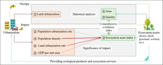
3.2. Research on the Impact Mechanism of Urbanization on Changes in Ecosystem Assets

3.2.1. Urbanization Background

The basic situation of urbanization and its changes in the Beijing–Tianjin–Hebei urban agglomeration are shown in Figure 12. It can be seen that the spatial distributions of the population urbanization level, population density, GDP per unit area, and land urbanization level of the Beijing–Tianjin–Hebei urban agglomeration have obvious similarities. The urbanization level indicators of the plain areas in the southeastern part of the Beijing–Tianjin–Hebei urban agglomeration are significantly higher than those in the northern and western mountainous areas, and the urbanization indicators of Beijing, Tianjin, Tangshan, Shijiazhuang, and Handan are significantly higher than those of other regions (Figure 12A–D). From 2000 to 2015, various urbanization indicators showed an overall upward trend. Although the spatial distribution of the districts and counties with the most significant increase in population urbanization is relatively scattered, the districts and counties with the most obvious increases in population density, GDP per unit area, and land urbanization are mainly concentrated in the vast plains of the Beijing–Tianjin–Hebei urban agglomeration, especially in the two municipalities directly under the central government, Beijing and Tianjin. However, there are still some districts and counties with a downward trend in urbanization indicators. There are 25 districts and counties where the population urbanization level has declined, 24 districts and counties where population density has declined, 52 districts and counties with a decline in GDP per unit area, and 9 districts and counties where the level of land urbanization has declined (Figure 12E–H).

3.2.2. The Impact Mechanism of Urbanization on Ecosystem Assets

According to the correlation between the changes in the county-level ecosystem asset index and the changes in various urbanization indicators in the Beijing–Tianjin–Hebei urban agglomeration from 2000 to 2015, with the exception of the population urbanization rate, the growth of urbanization indicators has almost always had a significant negative impact on the natural ecosystem asset index. In terms of the types of urbanization indicators, population density growth has the greatest impact on the natural ecosystem asset index; the impact of land urbanization growth on the natural ecosystem asset index is slightly less than the negative impact of population density growth; and the growth in GDP per unit area has a subsequent impact on the natural ecosystem asset index, but only has a significant negative impact on the forest ecosystem asset index. In terms of the types of natural ecosystem asset indices, the forest ecosystem asset index is most affected by urbanization; the shrub and the comprehensive ecosystem asset indices are less affected by urbanization; and the influence of urbanization on the grassland ecosystem asset index is relatively small, confined to the influence of population density growth on the grassland ecosystem asset index, which is significant (Figure 13).

4. Discussion

4.1. Impact of Land Urbanization on Area and Pattern of Other Ecosystem Assets

4.1.1. Impact of Land Urbanization on Area of Other Ecosystem Assets

From 2000 to 2015, the ecosystem area of the Beijing–Tianjin–Hebei urban agglomeration was dominated by degradation, and land urbanization was the primary reason for the degradation of the ecosystem asset area, although, despite being the leading cause of reduction in farmland, land urbanization is not the primary factor causing the reduction in wetlands, forests, shrubs, and grasslands. However, taking into account the “balance of cultivated land occupied and complimented” policy formulated by the Chinese government with the goal of protecting cultivated land [69,70,71], it can be inferred that the new cultivated land reclamation is the result of land urbanization occupying farmland; that is, the cultivated land reclamation is the result of land urbanization. Through analysis, it was found that the area of ecosystem assets degradation directly and indirectly caused by land urbanization accounted for 68.64% of the total area of ecosystem degradation. It accounted for 65.97% and 94.34% of the area of wetlands and grassland degradation, respectively, and 16.57% and 45.72% of the area of forest and shrub degradation, respectively, and was the second largest cause of forest and shrub degradation. It can be seen that the negative impact of land urbanization on the area of ecosystem assets is not as simple as direct encroachment. The occupation of farmland through land urbanization will lead to a series of chain reactions, and the control over the occupation of farmland by land urbanization should be strengthened. In this study, returning farmland to forests, grasslands, and wetlands and afforestation are the first and second driving forces, respectively, for the restoration of the ecosystem asset area of the Beijing–Tianjin–Hebei urban agglomeration, accounting for 87.84% of the ecologically restored area. We should continue to implement such ecosystem protection and restoration projects.

4.1.2. Impact of Land Urbanization on Patterns of Other Ecosystem Assets

The overall landscape pattern of the Beijing–Tianjin–Hebei urban agglomeration has become more fragmented. Except for the farmland and wetland landscape pattern, the ecosystems have become more fragmented, and urban fragmentation has increased especially quickly. According to existing studies, the fragmentation of forest, shrub, and grassland ecosystems is not conducive to species diversity protection [72,73]. In addition, it will weaken the ecosystem service function [74,75]. Moreover, the intensification of urban land fragmentation is not conducive to the improvement of urban resources, energy, and economic efficiency [76,77]. Therefore, future urbanization should pay attention to the planning of ecosystem landscape patterns and the centralized and intensive development of land urbanization.

4.2. Impact of Land Urbanization on the Quality of Other Ecosystem Assets

The quality of the forest and shrub ecosystem assets in the Beijing–Tianjin–Hebei urban agglomeration is significantly low. In 2000, the percentage of forest and shrub ecosystem assets of inferior and poor grade reached 94.92% and 92.94%, respectively, and by 2015 it had decreased to 54.4% and 55.55%, respectively. The quality of the grassland ecosystem assets is much better. In 2000, the percentage of excellent and good was 55.77%, and by 2015 it had reached 80.49%. From 2000 to 2015, the degraded areas of the forest, shrub, and grassland ecosystem asset quality accounted for only 2.16%, 4.23%, and 4.91% of the total area of the relatively stable forest, shrub, and grassland ecosystems in the past 15 years, respectively, while the optimized areas reached 69.48%, 62.22%, and 54.6%, respectively. This means that the asset quality of the forest, shrub, and grassland ecosystems has been significantly improved during the rapid urbanization process of the Beijing–Tianjin–Hebei urban agglomeration, especially the asset quality of the forest and shrub ecosystems, which still has much room for improvement. It can be seen that the quality of ecosystem assets is significantly improved in the process of rapid urbanization. This is probably because, with the development of urbanization, people’s awareness of ecological protection and restoration has been significantly enhanced, and the investment in this area has also increased significantly [78,79].

4.3. Impact of Land Urbanization on Other Ecosystem Asset Indices

From 2000 to 2015, the asset index of the natural ecosystem at county level in the Beijing–Tianjin–Hebei urban agglomeration mainly increased, and the asset index of the natural ecosystem at the scale of urban agglomeration also increased significantly, which indicates that the overall ecosystem asset status of the Beijing–Tianjin–Hebei urban agglomeration was optimized in the process of rapid urbanization, and only the ecosystem asset status of individual regions was degraded. It also indicates that, to a certain extent, the loss caused by the loss of natural ecosystem assets can be compensated for by improving the quality of natural ecosystem assets. For example, the area of ecosystem assets decreased, the quality improved, and the index of ecosystem assets increased [5,18].

4.4. Impact Mechanism of Urbanization on Ecosystem Assets

From 2000 to 2015, in addition to the population urbanization rate, the growth of other urbanization indicators in the Beijing–Tianjin–Hebei urban agglomeration had a significant negative impact on the natural ecosystem asset index. Among them, the growth in population density had the greatest impact, followed by the growth in land urbanization, and finally, the GDP per unit area growth. Thus, there is no need to worry about the growth in the population urbanization rate. However, if people want to prevent the natural ecosystem asset index from declining, the growth in population density, GDP per unit area, and land urbanization must be controlled. There is no doubt that land urbanization is an important cause of ecosystem degradation [20]. However, it is worth noting that the impact of population density on the comprehensive status of ecosystem assets is more serious than that of land urbanization.

5. Conclusions

This study analyzes the temporal and spatial changes in the ecosystem assets of the Beijing–Tianjin–Hebei urban agglomeration from many angles, including the area, pattern, and quality of the ecosystem assets. It emphasizes the impact of land urbanization and, for the first time, comprehensively evaluates the area and quality of the ecosystem assets of the Beijing–Tianjin–Hebei urban agglomeration, while also analyzing the impact mechanism of urbanization. The main conclusions of this study are as follows:
  • From 2000 to 2015, the ecosystem area of the Beijing–Tianjin–Hebei urban agglomeration was mainly degraded, and land urbanization directly and indirectly caused 68.64% of the ecosystem degradation. It is the main reason for the reduction in farmland, wetland, and grassland area, and the secondary reason for the reduction in forest and shrub area. To protect and restore the area of ecosystem assets, first, it is necessary to strengthen the control of farmland occupied by land urbanization, and, second, it is necessary to adhere to the implementation of ecosystem protection and restoration projects, such as returning farmland to forests and grasslands.
  • From 2000 to 2015, the overall landscape pattern of the Beijing–Tianjin–Hebei urban agglomeration has become more fragmented. Except for the farmland and wetlands, the ecosystems have become more fragmented, especially the urban areas. In the process of future urbanization, people should pay attention to the intensive and concentrated development of land urbanization and try to avoid further fragmentation of the ecosystem landscape pattern.
  • From 2000 to 2015, the asset quality of natural ecosystems in the rapid urbanization process of the Beijing–Tianjin–Hebei urban agglomeration was significantly improved, but there is still much room for improvement in the asset quality of the forest and shrub ecosystems. It can be seen that, although urbanization occupies the area of ecosystem assets, it is helpful in improving the quality of ecosystem assets.
  • From 2000 to 2015, the natural ecosystem assets of most districts and counties in the Beijing–Tianjin–Hebei urban agglomeration, as well as those of the urban agglomeration as a whole, have significantly improved, indicating that a joint improvement of urbanization and ecosystem assets can be achieved. Furthermore, in the case of unavoidable reductions in the area of natural ecosystem assets, the loss of natural ecosystem assets can be slowed down or even reversed by improving the quality of the natural ecosystem assets.
  • In the process of urbanization, vigorously developing and improving the level of the population urbanization rate will not significantly affect the overall situation of natural ecosystem assets. However, if people want to protect and maintain the overall situation of natural ecosystem assets, people must strictly control the growth in urban population density and land urbanization level first, and then the growth in urban GDP per unit area.
The importance of this article lies in the fact that it clarifies that improving the quality of ecosystem assets is an effective way to make up for the losses caused by the reduction in the area of ecosystem assets, thus revealing a feasible path of coordinated and sustainable development of land urbanization and ecosystem assets, and also pointing out that attention should be paid to the relevant indicators of macro-control in the process of urbanization development. This study has important implications for other studies that focus on ecosystem assets, such as ecosystem services, and reminds researchers to further explore the comprehensive impact of the area and quality of ecosystem assets as part of their research process.

Author Contributions

Conceptualization, Y.C. and Z.O.; methodology, Y.C. and Z.O.; software, Y.C.; validation, Y.C., L.K. and Z.O.; formal analysis, Y.C.; investigation, Y.C. and L.K.; resources, Z.O.; data curation, Y.C. and L.K.; writing—original draft preparation, Y.C.; writing—review and editing, Y.C., L.K. and Z.O.; visualization, Y.C.; supervision, Z.O.; project administration, Y.C.; funding acquisition, Z.O. and L.K. All authors have read and agreed to the published version of the manuscript.

Funding

This research was funded by the Strategic Priority Research Program of the Chinese Academy of Sciences, grant number XDA19050504, and the National Nature Science Foundation of China, grant number 41901257.

Data Availability Statement

The land cover data set of the study in 2000 and 2015 is from the China Ecosystem Assessment and Ecological Security Database: https://www.ecosystem.csdb.cn/ecogj/index.jsp, which accessed on 1 June 2021. The Digital Elevation Model comes from the Geographic Data Cloud: http://www.gscloud.cn, which accessed on 1 October 2022. The biomass data and vegetation coverage data come from the Remote Sensing Survey and Assessment Project of the National Ten Year Change of Ecological Environment (2000–2010) of the Chinese Academy of Sciences and the Ministry of Ecological Environment, and the Remote Sensing Survey and Assessment Project of the National Five Year Change of Ecological Environment (2010–2015). The data of total population, urban resident population, GDP, and district/county GDP deflator are from the relevant statistical yearbooks.

Acknowledgments

We thank the China Ecosystem Assessment and Ecological Security Database for providing the land cover data.

Conflicts of Interest

The authors declare no conflict of interest.

References

  1. United Nations. Frequently Asked Questions|System of Environmental Economic Accounting. Available online: https://seea.un.org/content/frequently-asked-questions#What%20are%20ecosystem%20assets? (accessed on 12 October 2022).
  2. United Nations. Ecosystem Accounting|System of Environmental Economic Accounting. Available online: https://seea.un.org/ecosystem-accounting (accessed on 12 October 2022).
  3. Li, J.; Huang, L.; Cao, W. The influencing mechanism of ecological asset gains and losses at the county level in China and its optimization and promotion paths. Acta Geogr. Sin. 2022, 77, 1260–1274. [Google Scholar] [CrossRef]
  4. Ouyang, Z.; Zheng, H.; Xie, G.; Yang, W.; Liu, G.; Shi, Y.; Yang, D. Accounting theories and technologies for ecological assets, ecological compensation and scientific and technological contribution to ecological civilization. Acta Ecol. Sin. 2016, 36, 7136–7139. [Google Scholar] [CrossRef]
  5. Qiu, X.; Xiao, Y.; Shi, L.; Wang, H.; Liu, Y.; Sun, H. Assessment of ecological conservation benefit in the Inner Mongolia based on ecological assets. Acta Ecol. Sin. 2022, 42, 5255–5263. [Google Scholar] [CrossRef]
  6. Yu, G.; Yang, M. Ecological Economics Foundation Research on Ecological Values, Ecological Asset Management, and Value Realization: Scientific Concepts, Basic Theories, and Realization Paths. Chin. J. Appl. Ecol. 2022, 33, 1153–1165. [Google Scholar] [CrossRef]
  7. Zhang, L.; Guo, K.; Li, B.; Lv, Y.; Zhang, L.; Ouyang, Z. Ecological asset accounting in North District of Tanggula Mountain. Acta Ecol. Sin. 2020, 40, 3229–3235. [Google Scholar] [CrossRef]
  8. Dominati, E.J.; Robinson, D.A.; Marchant, S.C.; Bristow, K.L.; Mackay, A.D. Natural Capital, Ecological Infrastructure, and Ecosystem Services in Agroecosystems. In Encyclopedia of Agriculture and Food Systems; Van Alfen, N.K., Ed.; Academic Press: Cambridge, MA, USA, 2014; Volume 4, pp. 245–264. [Google Scholar]
  9. Bateman, I.J.; Mace, G.M. The Natural Capital Framework for Sustainably Efficient and Equitable Decision Making. Nat. Sustain. 2020, 3, 776–783. [Google Scholar] [CrossRef]
  10. Vardon, M.J.; Keith, H.; Burnett, P.; Lindenmayer, D.B. From Natural Capital Accounting to Natural Capital Banking. Nat. Sustain. 2021, 4, 832–834. [Google Scholar] [CrossRef]
  11. Barbier, E.B. The Concept of Natural Capital. Oxf. Rev. Econ. Policy 2019, 35, 14–36. [Google Scholar] [CrossRef]
  12. Ouyang, Z.; Zheng, H.; Xiao, Y.; Polasky, S.; Liu, J.; Xu, W.; Wang, Q.; Zhang, L.; Rao, E.; Jiang, L.; et al. Improvements in Ecosystem Services from Investments in Natural Capital. Science 2016, 352, 1455–1459. [Google Scholar] [CrossRef]
  13. National Research Council. Valuing Ecosystem Services: Toward Better Environmental Decision-Making; The National Academies Press: Washington, DC, USA, 2004; ISBN 978-0-309-09318-7. [Google Scholar]
  14. Hein, L.; Bagstad, K.; Edens, B.; Obst, C.; de Jong, R.; Lesschen, J.P. Defining Ecosystem Assets for Natural Capital Accounting. PLoS ONE 2016, 11, e0164460. [Google Scholar] [CrossRef]
  15. Obst, C.; Hein, L.; Edens, B. National Accounting and the Valuation of Ecosystem Assets and Their Services. Environ. Resour. Econ. 2016, 64, 1–23. [Google Scholar] [CrossRef]
  16. Vargas, L.; Hein, L.; Remme, R. Accounting for Ecosystem Assets Using Remote Sensing in the Colombian Orinoco River Basin Lowlands. J. Appl. Remote Sens. 2017, 11, 026008. [Google Scholar] [CrossRef]
  17. Bo, W.; Xiao, Y.; Wang, L.; Wang, X.; Ouyang, Z. Assessment of the status of ecological assets and variation of its characteristics: A case study of Hinggan League, Inner Mongolia. Acta Ecol. Sin. 2019, 39, 5425–5432. [Google Scholar] [CrossRef]
  18. Huang, B.; Li, R.; Ding, Z.; O’Connor, P.; Kong, L.; Xiao, Y.; Xu, W.; Guo, Y.; Yang, Y.; Li, R.; et al. A New Remote-Sensing-Based Indicator for Integrating Quantity and Quality Attributes to Assess the Dynamics of Ecosystem Assets. Glob. Ecol. Conserv. 2020, 22, e00999. [Google Scholar] [CrossRef]
  19. Akubia, J.E.K.; Ahmed, A.; Bruns, A. Assessing How Land-Cover Change Associated with Urbanisation Affects Ecological Sustainability in the Greater Accra Metropolitan Area, Ghana. Land 2020, 9, 182. [Google Scholar] [CrossRef]
  20. Cao, Y.; Kong, L.; Zhang, L.; Ouyang, Z. Spatial Characteristics of Ecological Degradation and Restoration in China from 2000 to 2015 Using Remote Sensing. Restor. Ecol. 2020, 28, 1419–1430. [Google Scholar] [CrossRef]
  21. Zang, S.; Wu, C.; Liu, H.; Na, X. Impact of Urbanization on Natural Ecosystem Service Values: A Comparative Study. Environ. Monit. Assess. 2011, 179, 575–588. [Google Scholar] [CrossRef]
  22. Ai, J.; Feng, L.; Dong, X.; Zhu, X.; Li, Y. Exploring Coupling Coordination between Urbanization and Ecosystem Quality (1985–2010): A Case Study from Lianyungang City, China. Front. Earth Sci. 2016, 10, 527–545. [Google Scholar] [CrossRef]
  23. Hu, X.; Xu, H. A New Remote Sensing Index for Assessing the Spatial Heterogeneity in Urban Ecological Quality: A Case from Fuzhou City, China. Ecol. Indic. 2018, 89, 11–21. [Google Scholar] [CrossRef]
  24. Zhu, C.; Zhang, X.; Zhou, M.; He, S.; Gan, M.; Yang, L.; Wang, K. Impacts of Urbanization and Landscape Pattern on Habitat Quality Using OLS and GWR Models in Hangzhou, China. Ecol. Indic. 2020, 117, 106654. [Google Scholar] [CrossRef]
  25. Li, C.; Sun, G.; Cohen, E.; Zhang, Y.; Xiao, J.; McNulty, S.G.; Meentemeyer, R.K. Modeling the Impacts of Urbanization on Watershed-Scale Gross Primary Productivity and Tradeoffs with Water Yield across the Conterminous United States. J. Hydrol. 2020, 583, 124581. [Google Scholar] [CrossRef]
  26. Hang, X.; Luo, X.; Cao, Y.; Li, Y. Ecological quality assessment and the impact of urbanization based on RSEI model for Nanjing, Jiangsu Province, China. Chin. J. Ecol. 2020, 31, 219–229. [Google Scholar] [CrossRef]
  27. Jiang, C.; Wu, Z.; Cheng, J.; Yu, Q.; Rao, X.Q. Impacts of Urbanization on Net Primary Productivity in the Pearl River Delta, China. Int. J. Plant Sci. 2015, 9, 581–598. [Google Scholar] [CrossRef]
  28. Xu, C.; Liu, M.; An, S.; Chen, J.M.; Yan, P. Assessing the Impact of Urbanization on Regional Net Primary Productivity in Jiangyin County, China. J. Environ. Manag. 2007, 85, 597–606. [Google Scholar] [CrossRef] [PubMed]
  29. Ren, X.; Zhang, M.; Qian, J.; Li, S.; Wang, J.; Du, J. Analyzing Spatio-Temporal Change in Ecosystem Quality and Its Driving Mechanism in Henan Province, China, from 2010 to 2020. Sustainability 2022, 14, 11742. [Google Scholar] [CrossRef]
  30. Xing, L.; Xue, M.; Hu, M. Dynamic Simulation and Assessment of the Coupling Coordination Degree of the Economy–Resource–Environment System: Case of Wuhan City in China. J. Environ. Manag. 2019, 230, 474–487. [Google Scholar] [CrossRef]
  31. Butsch, C.; Kumar, S.; Wagner, P.D.; Kroll, M.; Kantakumar, L.N.; Bharucha, E.; Schneider, K.; Kraas, F. Growing ‘Smart’? Urbanization Processes in the Pune Urban Agglomeration. Sustainability 2017, 9, 2335. [Google Scholar] [CrossRef] [Green Version]
  32. Liao, S.; Wu, Y.; Wong, S.W.; Shen, L. Provincial Perspective Analysis on the Coordination between Urbanization Growth and Resource Environment Carrying Capacity (RECC) in China. Sci. Total Environ. 2020, 730, 138964. [Google Scholar] [CrossRef]
  33. Wu, Y.; Zong, T.; Shuai, C.; Liao, S.; Jiao, L.; Shen, L. Does Resource Environment Carrying Capacity Have a Coercive Effect on Urbanization Quality? Evidence from the Yangtze River Economic Belt, China. J. Clean. Prod. 2022, 365, 132612. [Google Scholar] [CrossRef]
  34. Yang, Z.; Chen, Y.; Qian, Q.; Wu, Z.; Zheng, Z.; Huang, Q. The Coupling Relationship between Construction Land Expansion and High-Temperature Area Expansion in China’s Three Major Urban Agglomerations. Int. J. Remote Sens. 2019, 40, 6680–6699. [Google Scholar] [CrossRef]
  35. Zhang, D.; Huang, Q.; He, C.; Wu, J. Impacts of Urban Expansion on Ecosystem Services in the Beijing-Tianjin-Hebei Urban Agglomeration, China: A Scenario Analysis Based on the Shared Socioeconomic Pathways. Resour. Conserv. Recycl. 2017, 125, 115–130. [Google Scholar] [CrossRef]
  36. Ye, C.; Zhu, J.; Li, S.; Yang, S.; Chen, M. Assessment and Analysis of Regional Economic Collaborative Development within an Urban Agglomeration: Yangtze River Delta as a Case Study. Habitat Int. 2019, 83, 20–29. [Google Scholar] [CrossRef]
  37. Urban Population (% of Total Population)|Data. Available online: https://data.worldbank.org/indicator/SP.URB.TOTL.IN.ZS (accessed on 13 October 2022).
  38. Urban Population (% of Total Population)—China|Data. Available online: https://data.worldbank.org/indicator/SP.URB.TOTL.IN.ZS?locations=CN (accessed on 13 October 2022).
  39. United Nations, Department of Economic and Social Affairs, Population Division. World Urbanization Prospects: The 2018 Revision; United Nations: New York, NY, USA, 2019; ISBN 978-92-1-148319-2. [Google Scholar]
  40. World Urbanization Prospects—Population Division—United Nations. Available online: https://population.un.org/wup/Country-Profiles/ (accessed on 13 October 2022).
  41. Ning, J. Main Data of the Seventh National Population Census. Available online: http://www.stats.gov.cn/english/PressRelease/202105/t20210510_1817185.html (accessed on 13 October 2022).
  42. Yang, Y.; Qi, W.; Ma, L.; Liu, Y. Spatial optimization strategies of population function in China’s world-class urban agglomeration during 14th Five-Year Plan period. Bull. Chin. Acad. Sci. 2020, 35, 835–843. [Google Scholar] [CrossRef]
  43. National Health Commission of the People’s Republic of China. 2018 Report on China’s Migrant Population Development, 1st ed.; China Population Publishing House: Beijing, China, 2018; ISBN 978-7-5101-6379-1. [Google Scholar]
  44. Peng, J.; Chen, X.; Liu, Y.; Lü, H.; Hu, X. Spatial Identification of Multifunctional Landscapes and Associated Influencing Factors in the Beijing-Tianjin-Hebei Region, China. Appl. Geogr. 2016, 74, 170–181. [Google Scholar] [CrossRef]
  45. Yang, Y.; Bao, W.; Liu, Y. Scenario Simulation of Land System Change in the Beijing-Tianjin-Hebei Region. Land Use Policy 2020, 96, 104677. [Google Scholar] [CrossRef]
  46. Zhou, Y.; Chen, M.; Tang, Z.; Mei, Z. Urbanization, Land Use Change, and Carbon Emissions: Quantitative Assessments for City-Level Carbon Emissions in Beijing-Tianjin-Hebei Region. Sustain. Cities Soc. 2021, 66, 102701. [Google Scholar] [CrossRef]
  47. Tang, H.; Liu, W.; Yun, W. Spatiotemporal Dynamics of Green Spaces in the Beijing–Tianjin–Hebei Region in the Past 20 Years. Sustainability 2018, 10, 2949. [Google Scholar] [CrossRef] [Green Version]
  48. Wang, S.; Li, W.; Li, Q.; Wang, J. Ecological Security Pattern Construction in Beijing-Tianjin-Hebei Region Based on Hotspots of Multiple Ecosystem Services. Sustainability 2022, 14, 699. [Google Scholar] [CrossRef]
  49. Xie, H.; He, Y.; Xie, X. Exploring the Factors Influencing Ecological Land Change for China’s Beijing–Tianjin–Hebei Region Using Big Data. J. Clean. Prod. 2017, 142, 677–687. [Google Scholar] [CrossRef]
  50. Chu, M.; Lu, J.; Sun, D. Influence of Urban Agglomeration Expansion on Fragmentation of Green Space: A Case Study of Beijing-Tianjin-Hebei Urban Agglomeration. Land 2022, 11, 275. [Google Scholar] [CrossRef]
  51. Wang, Y.; Zhao, X.; Zuo, L.; Zhang, Z.; Wang, X.; Yi, L.; Liu, F.; Xu, J. Spatial Differentiation of Land Use and Landscape Pattern Changes in the Beijing–Tianjin–Hebei Area. Sustainability 2020, 12, 3040. [Google Scholar] [CrossRef] [Green Version]
  52. Zhao, Y.; Sun, R.; Ni, Z. Identification of Natural and Anthropogenic Drivers of Vegetation Change in the Beijing-Tianjin-Hebei Megacity Region. Remote Sens. 2019, 11, 1224. [Google Scholar] [CrossRef] [Green Version]
  53. Zhou, Q.; Zhao, X.; Wu, D.; Tang, R.; Du, X.; Wang, H.; Zhao, J.; Xu, P.; Peng, Y. Impact of Urbanization and Climate on Vegetation Coverage in the Beijing–Tianjin–Hebei Region of China. Remote Sens. 2019, 11, 2452. [Google Scholar] [CrossRef] [Green Version]
  54. Jiang, M.; He, Y.; Song, C.; Pan, Y.; Qiu, T.; Tian, S. Disaggregating Climatic and Anthropogenic Influences on Vegetation Changes in Beijing-Tianjin-Hebei Region of China. Sci. Total Environ. 2021, 786, 147574. [Google Scholar] [CrossRef]
  55. Cao, W.; Wu, D.; Huang, L.; Pan, M.; Huhe, T. Determinizing the Contributions of Human Activities and Climate Change on Greening in the Beijing–Tianjin–Hebei Region, China. Sci. Rep. 2021, 11, 21201. [Google Scholar] [CrossRef]
  56. Yang, Y.; Bao, W.; Li, Y.; Wang, Y.; Chen, Z. Land Use Transition and Its Eco-Environmental Effects in the Beijing–Tianjin–Hebei Urban Agglomeration: A Production–Living–Ecological Perspective. Land 2020, 9, 285. [Google Scholar] [CrossRef]
  57. Xu, K.; Chi, Y.; Wang, J.; Ge, R.; Wang, X. Analysis of the Spatial Characteristics and Driving Forces Determining Ecosystem Quality of the Beijing–Tianjin–Hebei Region. Environ. Sci. Pollut. Res. 2021, 28, 12555–12565. [Google Scholar] [CrossRef]
  58. Liu, L.; Sun, Z.; Wu, F.; Zhang, X.; Zhang, Q. Evaluation of suitability and emission reduction benefits of photovoltaic development in Beijing-Tianjin-Hebei region. Acta Geogr. Sin. 2022, 77, 665–678. [Google Scholar] [CrossRef]
  59. Yao, Q.; Tang, Y.; Cai, Z.; Yang, X.; Fan, W.; Han, S. Evaluation of PM2.5 pollution characteristics and formation mechanisms of typical cities in Beijing-Tianjin-Hebei region. Acta Sci. Circumst. 2022, 42, 43–52. [Google Scholar] [CrossRef]
  60. Yan, S.; Wang, H.; Jiao, K. Spatiotemporal dynamics of NDVI in the Beijing-Tianjin-Hebei region based on MODIS data and quantitative attribution. J. Geo-Inform. Sci. 2019, 21, 767–780. [Google Scholar] [CrossRef]
  61. Geospatial Data Cloud. Available online: http://www.gscloud.cn/sources/accessdata/aeab8000652a45b38afbb7ff023ddabb?pid=302 (accessed on 29 October 2022).
  62. China Ecosystem Assessment and Ecological Security Database. Available online: https://www.ecosystem.csdb.cn/ecogj/index.jsp (accessed on 13 October 2022).
  63. Geographic Data Cloud. Available online: http://www.gscloud.cn/#page6 (accessed on 13 October 2022).
  64. McNulty, K. Using NetworkD3 in R to Create Simple and Clear Sankey Diagrams. Available online: https://towardsdatascience.com/using-networkd3-in-r-to-create-simple-and-clear-sankey-diagrams-48f8ba8a4ace (accessed on 3 November 2022).
  65. Liu, J.; Liu, X.; Hou, L. Changes and ecological vulnerability of landscape pattern in Eastern Qilian Mountain. Arid. Land Geogr. 2012, 35, 795–805. [Google Scholar] [CrossRef]
  66. Wang, X.; Bu, R.; Hu, Y.; Xiao, D. Landscape fragmentation analysis of wetlands in Liaohe River Delta. Chin. J. Appl. Ecol. 1996, 3, 299–304. [Google Scholar] [CrossRef]
  67. Landscape Metrics for Categorical Map Patterns. Available online: https://r-spatialecology.github.io/landscapemetrics/ (accessed on 2 November 2022).
  68. Wei, T.; Simko, V. An Introduction to Corrplot Package. Available online: https://cran.r-project.org/web/packages/corrplot/vignettes/corrplot-intro.html (accessed on 3 November 2022).
  69. Chen, W.; Ye, X.; Li, J.; Fan, X.; Liu, Q.; Dong, W. Analyzing Requisition–Compensation Balance of Farmland Policy in China through Telecoupling: A Case Study in the Middle Reaches of Yangtze River Urban Agglomerations. Land Use Policy 2019, 83, 134–146. [Google Scholar] [CrossRef]
  70. Deng, Z.; Zhao, Q.; Bao, H. The Impact of Urbanization on Farmland Productivity: Implications for China’s Requisition–Compensation Balance of Farmland Policy. Land 2020, 9, 311. [Google Scholar] [CrossRef]
  71. Liu, L.; Liu, Z.; Gong, J.; Wang, L.; Hu, Y. Quantifying the Amount, Heterogeneity, and Pattern of Farmland: Implications for China’s Requisition-Compensation Balance of Farmland Policy. Land Use Policy 2019, 81, 256–266. [Google Scholar] [CrossRef]
  72. Betts, M.; Wolf, C.; Pfeifer, M.; Banks-Leite, C.; Arroyo-Rodríguez, V.; Ribeiro, D.; Barlow, J.; Eigenbrod, F.; Faria, D.; Fletcher, R.; et al. Extinction Filters Mediate the Global Effects of Habitat Fragmentation on Animals. Science 2019, 366, 1236–1239. [Google Scholar] [CrossRef] [PubMed] [Green Version]
  73. Damschen, E.I.; Brudvig, L.A.; Burt, M.A.; Fletcher, R.J.; Haddad, N.M.; Levey, D.J.; Orrock, J.L.; Resasco, J.; Tewksbury, J.J. Ongoing Accumulation of Plant Diversity through Habitat Connectivity in an 18-Year Experiment. Science 2019, 365, 1478–1480. [Google Scholar] [CrossRef]
  74. Wang, Y.; Zhou, Z.; Guo, Z. Impact of the urban agricultural landscape fragmentation on ecosystem services: A case study of Xi’an City. Geogr. Res. 2014, 33, 1097–1105. [Google Scholar] [CrossRef]
  75. Zhang, J.; Liu, D.; Gong, J.; Ma, X.; Cao, E. Impact of landscape fragmentation on watershed soil conservation service—A case study on Bailongjiang Watershed of Gansu. Resour. Sci. 2018, 40, 1866–1877. [Google Scholar] [CrossRef]
  76. Cao, Y.; Wu, T.; Kong, L.; Wang, X.; Zhang, L.; Ouyang, Z. The Drivers and Spatial Distribution of Economic Efficiency in China’s Cities. J. Geogr. Sci. 2022, 32, 1427–1450. [Google Scholar] [CrossRef]
  77. Yuan, Q.; Guo, R.; Leng, H.; Song, S. Research on the impact of urban form of small and medium-sized cities on carbon emission efficiency in the Yangtze River Delta. J. Hum. Settl. West China 2021, 36, 8–15. [Google Scholar] [CrossRef]
  78. Guo, S. Increment of investment on environment protecction is the key point of compensation for ecological debt. Chin. J. Eco-Agric. 2008, 16, 1302–1304. [Google Scholar] [CrossRef]
  79. Wu, N.; Wang, Y.; Wu, J.; Feng, Q.; Li, S.; Fu, Z. Analysis on the relationship between environmental protection investment and changes in resources and environment. J. Environ. Eng. Technol. 2021, 11, 187–193. [Google Scholar] [CrossRef]
Figure 1. Study area: (A) the location of the Beijing–Tianjin–Hebei urban agglomeration in China; (B) the administrative division and elevation of the Beijing–Tianjin–Hebei urban agglomeration.
Remotesensing 14 05747 g001
Figure 2. Areas of ecosystems in the Beijing–Tianjin–Hebei urban agglomeration in 2000 and 2015.
Remotesensing 14 05747 g002
Figure 3. Proportion of ecosystems in the Beijing–Tianjin–Hebei urban agglomeration in 2000 and 2015.
Remotesensing 14 05747 g003
Figure 4. Area changes and area change ratios of ecosystems in the Beijing–Tianjin–Hebei urban agglomeration from 2000 to 2015.
Remotesensing 14 05747 g004
Figure 5. Distribution and changes in ecosystems in the Beijing–Tianjin–Hebei urban agglomeration: (A) spatial distribution of ecosystems in the Beijing–Tianjin–Hebei urban agglomeration in 2015; (B) spatial distribution of ecosystem changes in the Beijing–Tianjin–Hebei urban agglomeration from 2000 to 2015.
Remotesensing 14 05747 g005
Figure 6. Schematic diagram of the transition of ecosystem types in the Beijing–Tianjin–Hebei urban agglomeration from 2000 to 2015.
Remotesensing 14 05747 g006
Figure 7. Classification and changes in the quality of natural ecosystem assets in the Beijing–Tianjin–Hebei urban agglomeration from 2000 to 2015.
Remotesensing 14 05747 g007
Figure 8. Distribution and changes in the quality of natural ecosystem assets in the Beijing–Tianjin–Hebei urban agglomeration from 2000 to 2015: (A) spatial distribution of forest ecosystem quality in 2015; (B) spatial distribution of shrub ecosystem quality in 2015; (C) spatial distribution of grassland ecosystem quality in 2015; (D) spatial distribution of forest ecosystem quality change from 2000 to 2015; (E) spatial distribution of shrub ecosystem quality change from 2000 to 2015; (F) spatial distribution of grassland ecosystem quality change from 2000 to 2015.
Remotesensing 14 05747 g008
Figure 9. Statistics of changes in the quality of natural ecosystem assets in the Beijing–Tianjin–Hebei urban agglomeration from 2000 to 2015.
Remotesensing 14 05747 g009
Figure 10. Distribution and changes in the county-level natural ecosystem asset index in the Beijing–Tianjin–Hebei urban agglomeration from 2000 to 2015: (A) spatial distribution of forest ecosystem asset index in 2015; (B) spatial distribution of shrub ecosystem asset index in 2015; (C) spatial distribution of grassland ecosystem asset index in 2015; (D) spatial distribution of natural ecosystem asset index in 2015; (E) spatial distribution of forest ecosystem asset index change from 2000 to 2015; (F) spatial distribution of shrub ecosystem asset index change from 2000 to 2015; (G) spatial distribution of grassland ecosystem asset index change from 2000 to 2015; (H) spatial distribution of natural ecosystem asset index change from 2000 to 2015.
Remotesensing 14 05747 g010
Figure 11. Natural ecosystem asset index and its change in the Beijing–Tianjin–Hebei urban agglomeration from 2000 to 2015.
Remotesensing 14 05747 g011
Figure 12. Development level and changes in county-level urbanization in the Beijing–Tianjin–Hebei urban agglomeration from 2000 to 2015. Note: Figure 12C is the current GDP in 2015, while Figure 12G is the difference between the actual GDP in 2015 based on the year 2000 and the current GDP in 2000.
Remotesensing 14 05747 g012
Figure 13. Correlation between county-level urbanization development and ecosystem asset index changes in the Beijing–Tianjin–Hebei urban agglomeration from 2000 to 2015. Note: *** represents a significant correlation at the 0.001 level; ** represents a significant correlation at the 0.01 level; * represents a significant correlation at the 0.05 level.
Remotesensing 14 05747 g013
Table 1. Grading standards for ecosystem asset quality.
Ecosystem Asset TypeEvaluating IndicatorQuality Grading Standard
ExcellentGoodMediumPoorBad
ForestRelative biomass density≥80%60–80%40–60%20–40%≤20%
ShrubRelative biomass density≥80%60–80%40–60%20–40%≤20%
GrasslandVegetation Coverage≥80%60–80%40–60%20–40%≤20%
Table 2. Ecosystem degradation of the Beijing–Tianjin–Hebei urban agglomeration from 2000 to 2015.
Ecosystem Degradation TypeLand Transfer TypeArea/km2Total Area/km2Ratio
Land urbanizationFarmland→urban5266.506452.4445.15%
Wetland→urban464.19
Grassland→urban377.67
Forest→urban188.24
Shrubland→urban116.29
Other lands→urban39.55
Cultivated land reclamationGrassland→farmland1077.573355.823.48%
Urban→farmland895.90
Wetland→farmland593.26
Forest→farmland474.77
Shrubland→farmland314.30
DeforestationForest→shrubland2847.523337.6223.36%
Forest→grassland469.83
Forest→other lands20.27
Vegetation destructionShrubland→grassland495.89598.414.19%
Grassland→other lands87.24
Shrubland→other lands15.28
Wetland atrophyWetland→grassland316.50545.413.82%
Wetland→other lands131.50
Wetland→forest60.80
Wetland→shrubland36.61
Total 14,289.6863.01%
Table 3. Ecosystem restoration of the Beijing–Tianjin–Hebei urban agglomeration from 2000 to 2015.
Ecosystem Restoration TypeLand Transfer TypeArea/km2Total Area/km2Ratio
Returning farmland to forest, grass and wetlandFarmland→forest2303.765213.9662.14%
Farmland→grassland1902.95
Farmland→wetland576.33
Farmland→shrubland344.36
Farmland→other lands86.56
AfforestationShrubland→forest1492.902156.6425.70%
Grassland→forest584.53
Urban→forest72.76
Other lands→forest6.45
Vegetation restorationGrassland→shrubland380.68642.557.66%
Urban→grassland159.89
Other lands→grassland63.40
Urban→shrubland31.98
Other lands→shrubland6.60
Wetland restorationUrban→wetland171.08344.294.10%
Grassland→wetland96.44
Forest→wetland33.75
Other lands→wetland29.25
Shrubland→wetland13.77
Cultivated land reclamationOther lands→farmland21.4921.490.26%
Natural ecosystem restorationUrban→other lands11.2611.260.13%
Total 8390.1936.99%
Table 4. Fragmentation and changes in ecosystem patterns of the Beijing–Tianjin–Hebei urban agglomeration from 2000 to 2015.
Ecosystem TypeLandscape Fragmentation IndexEcosystem TypeLandscape Fragmentation Index
20002015Increment20002015Increment
Forest0.18150.18290.0013Shrub0.10970.11430.0046
Grassland0.08120.08440.0032Wetland0.02780.0261−0.0017
Farmland0.42300.3919−0.0311Urban0.07470.09670.022
Other lands0.00210.00380.0017
Table 5. Classification and changes in the quality of natural ecosystem assets in the Beijing–Tianjin–Hebei urban agglomeration from 2000 to 2015.
TimeQualityForest/km2Ratio/%Shrub/km2Ratio/%Grassland/km2Ratio/%
2000Inferior25,065.8158.0813,631.1952.3846.880.24
Poor15,900.3836.8410,556.3840.561398.067.2
Medium1964.694.551752.316.737145.8836.79
Good176.630.4174.750.296731.534.65
Excellent47.560.119.560.044102.2521.12
2015Inferior11,416.7525.986622.4424.1835.50.18
Poor12,488.1928.42859331.37584.442.89
Medium11,210.8825.515990.521.873326.4416.45
Good5691.1912.953514.3112.836496.8132.12
Excellent3132.947.132669.639.759782.6948.37
2000–2015Inferior−13,649.06−32.1−7008.75−28.2−11.38−0.07
Poor−3412.19−8.42−1963.38−9.19−813.63−4.31
Medium9246.1920.964238.1915.14−3819.44−20.34
Good5514.5612.543439.5612.54−234.69−2.53
Excellent3085.387.022660.069.715680.4427.25
Publisher’s Note: MDPI stays neutral with regard to jurisdictional claims in published maps and institutional affiliations.

