Multitemporal Glacier Mass Balance and Area Changes in the Puruogangri Ice Field during 1975–2021 Based on Multisource Satellite Observations
Abstract
:1. Introduction
2. Study Area and Data
2.1. Study Area
2.2. Data
2.2.1. Optical Satellite Images
- (1)
- Landsat
- (2)
- KH-9
- (3)
- ZY-3
2.2.2. DEM Products
- (1)
- SRTM DEMs
- (2)
- Copernicus DEM
2.2.3. Satellite Altimetry Data
2.2.4. Meteorological Data
3. Methods
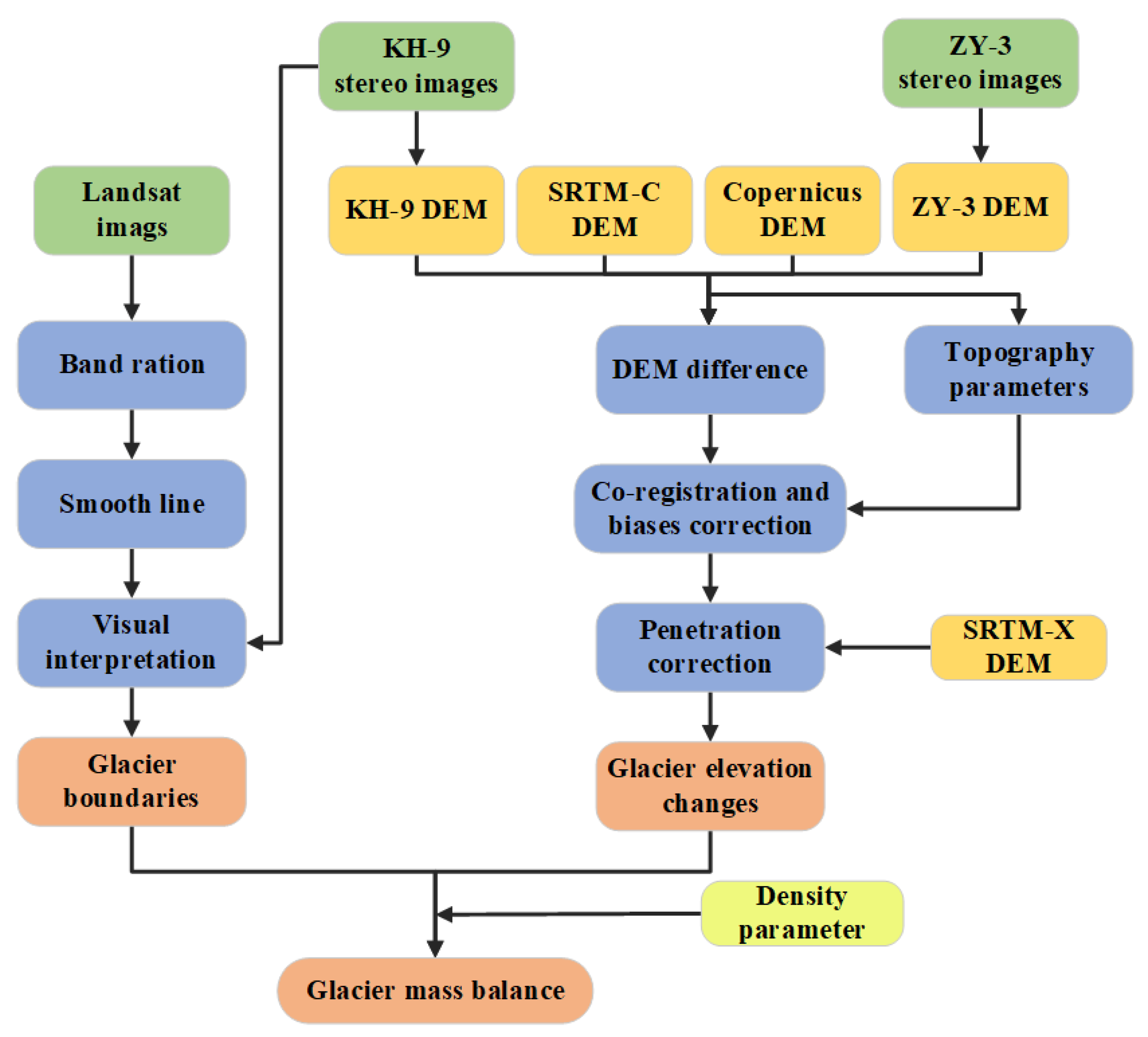
3.1. DEM Extraction
3.1.1. KH-9 DEM
3.1.2. ZY-3 DEMs
3.2. Glacier Boundary Delineation
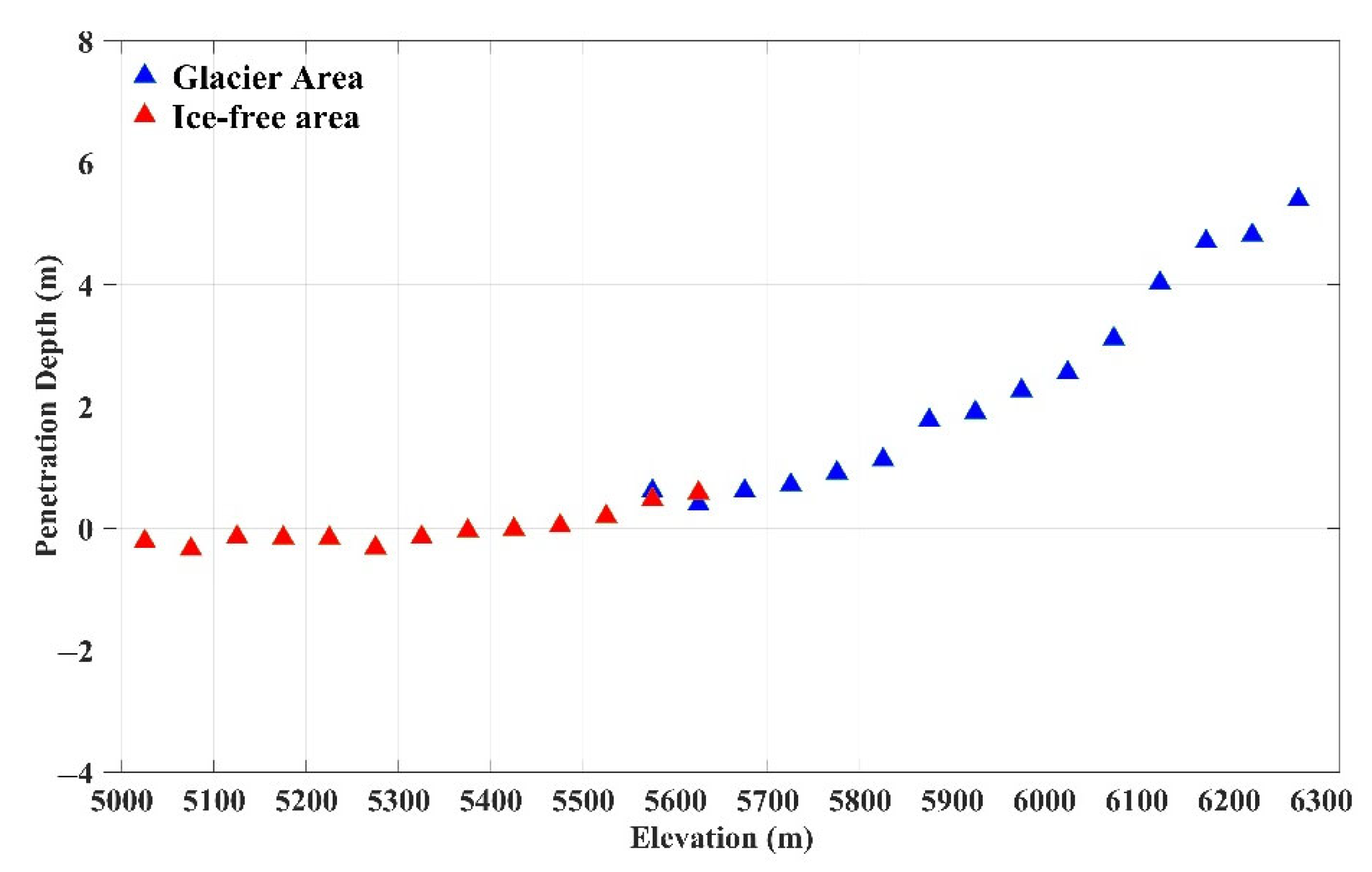
3.3. C-Band and X-Band Penetration Depth
3.4. Estimation of Changes in Glacier Elevation and Mass Balance
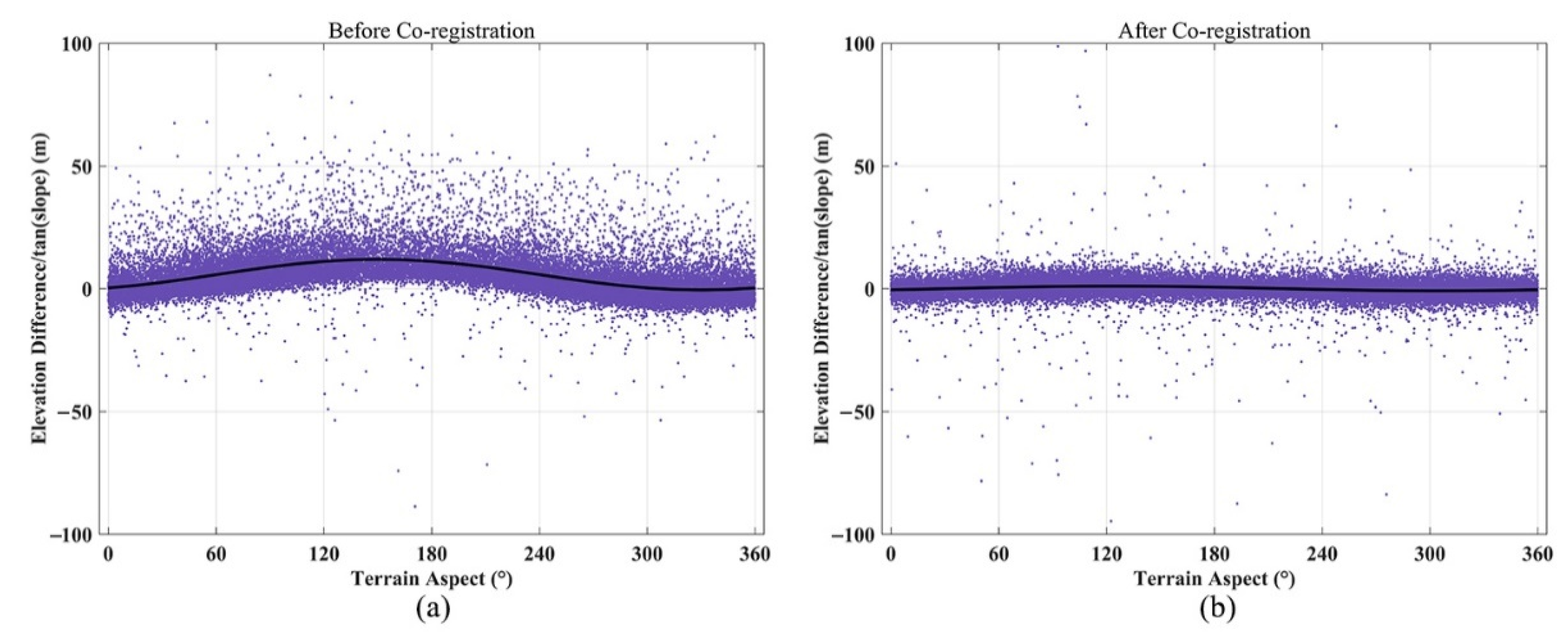
3.4.1. Estimation of Glacier Elevation Changes
3.4.2. Calculation of Glacier Mass Balance
3.5. Uncertainty Assessment
4. Results
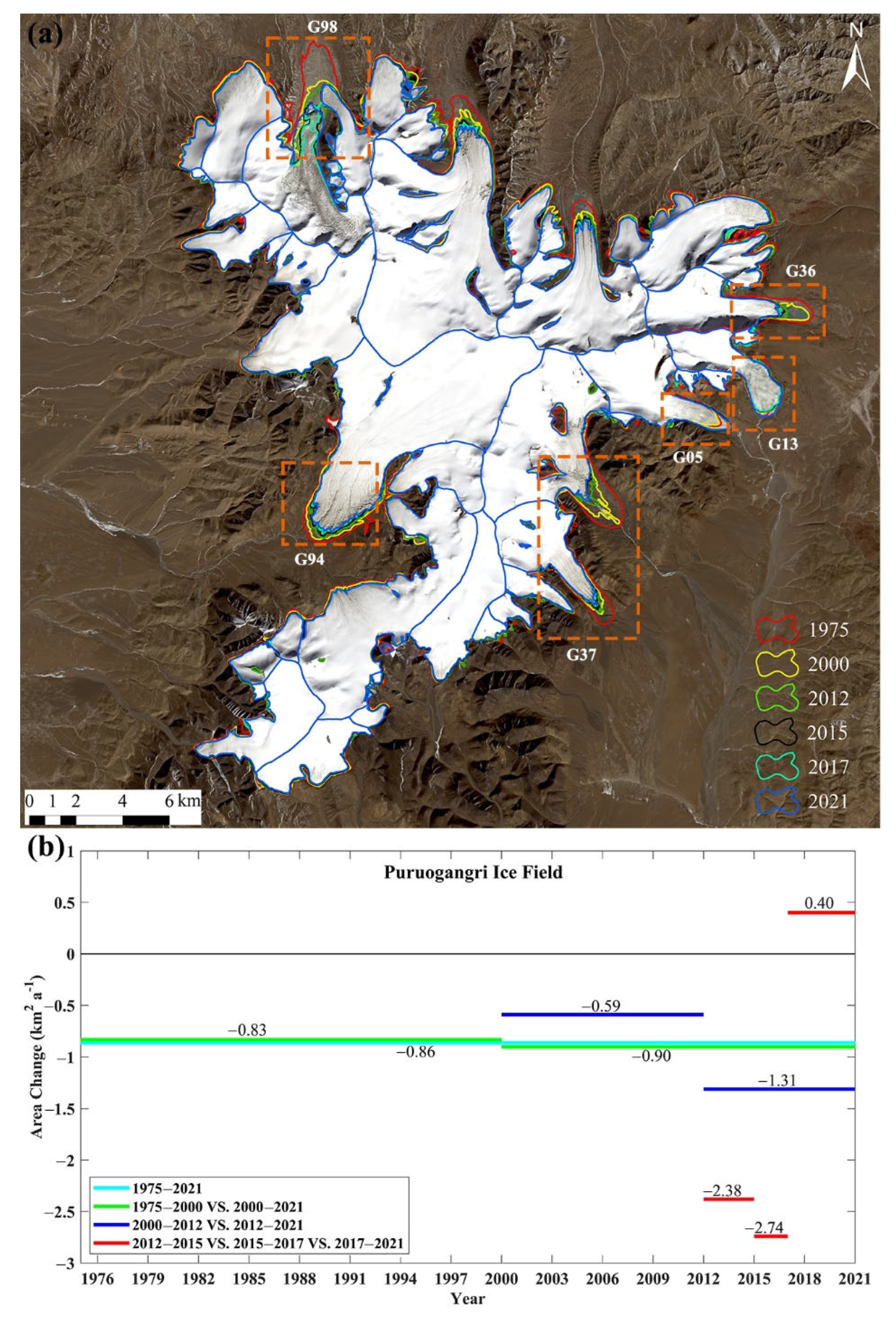
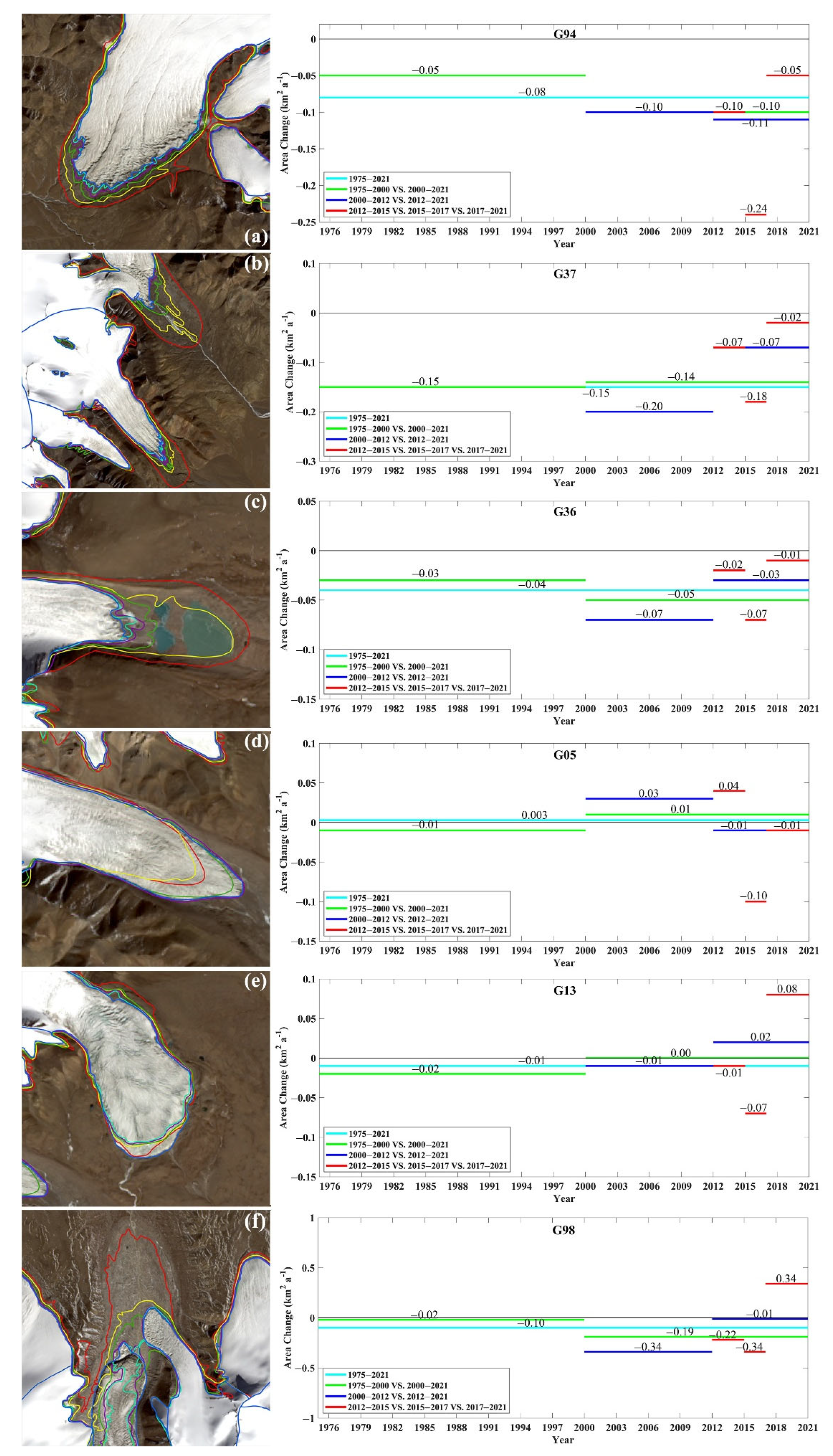
4.1. Changes in Glacier Area
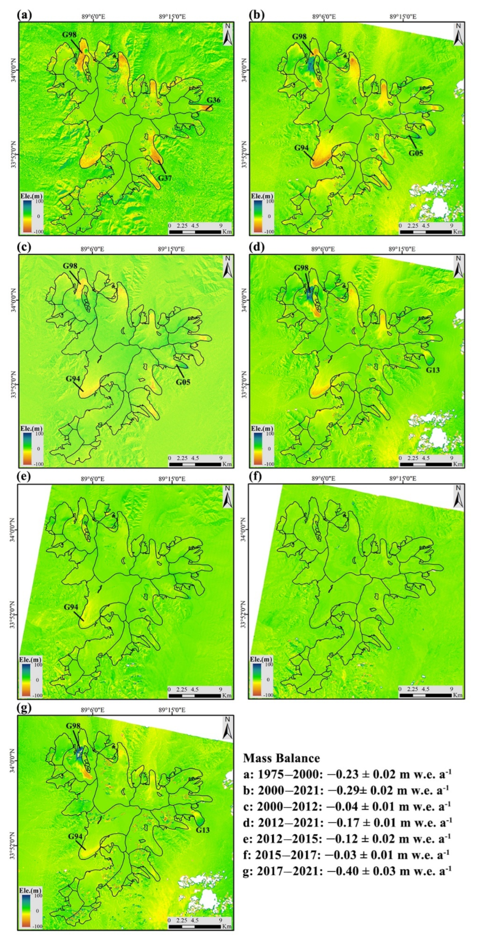
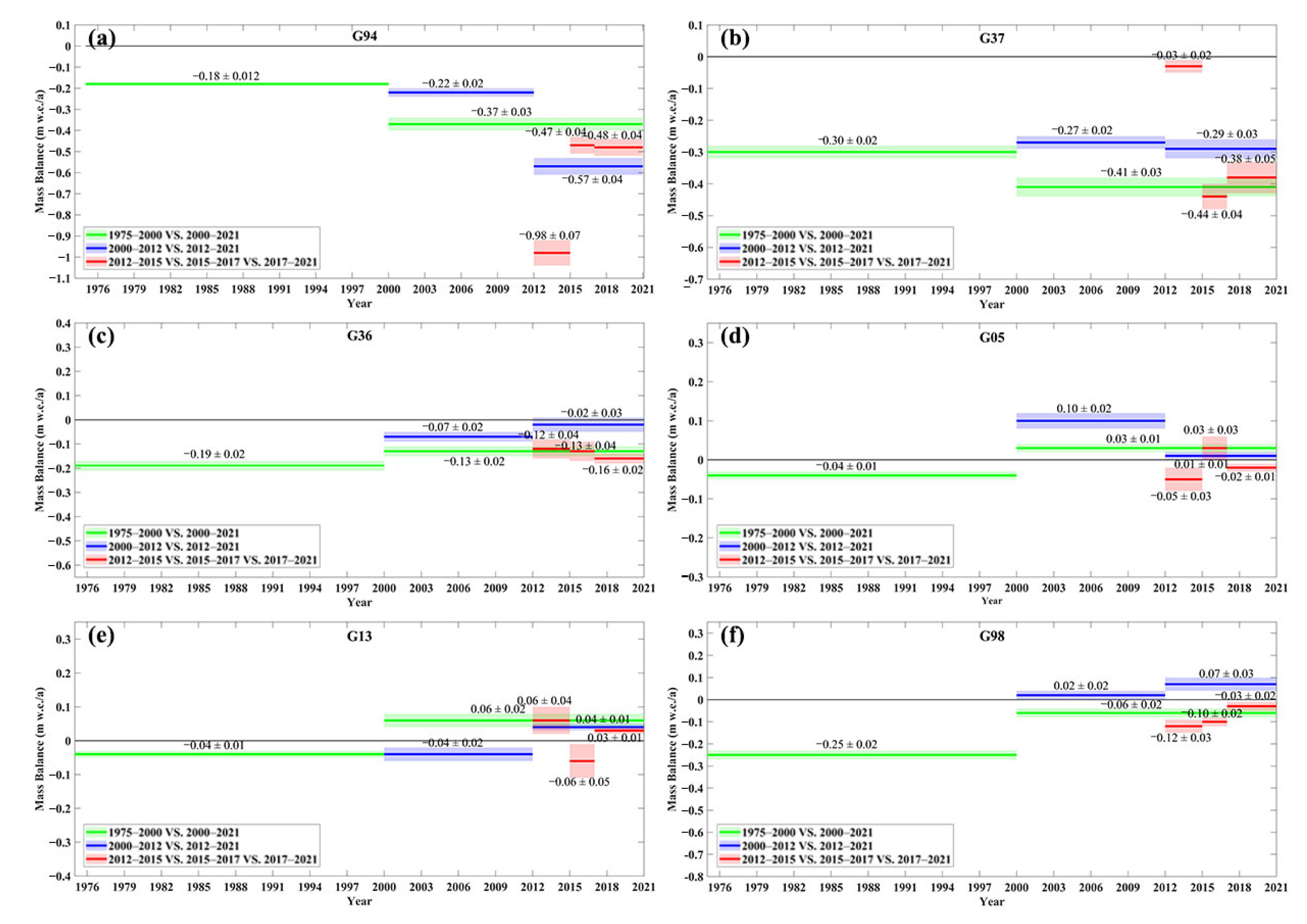
4.2. Changes in Glacier Elevation and Mass Balance
5. Discussion
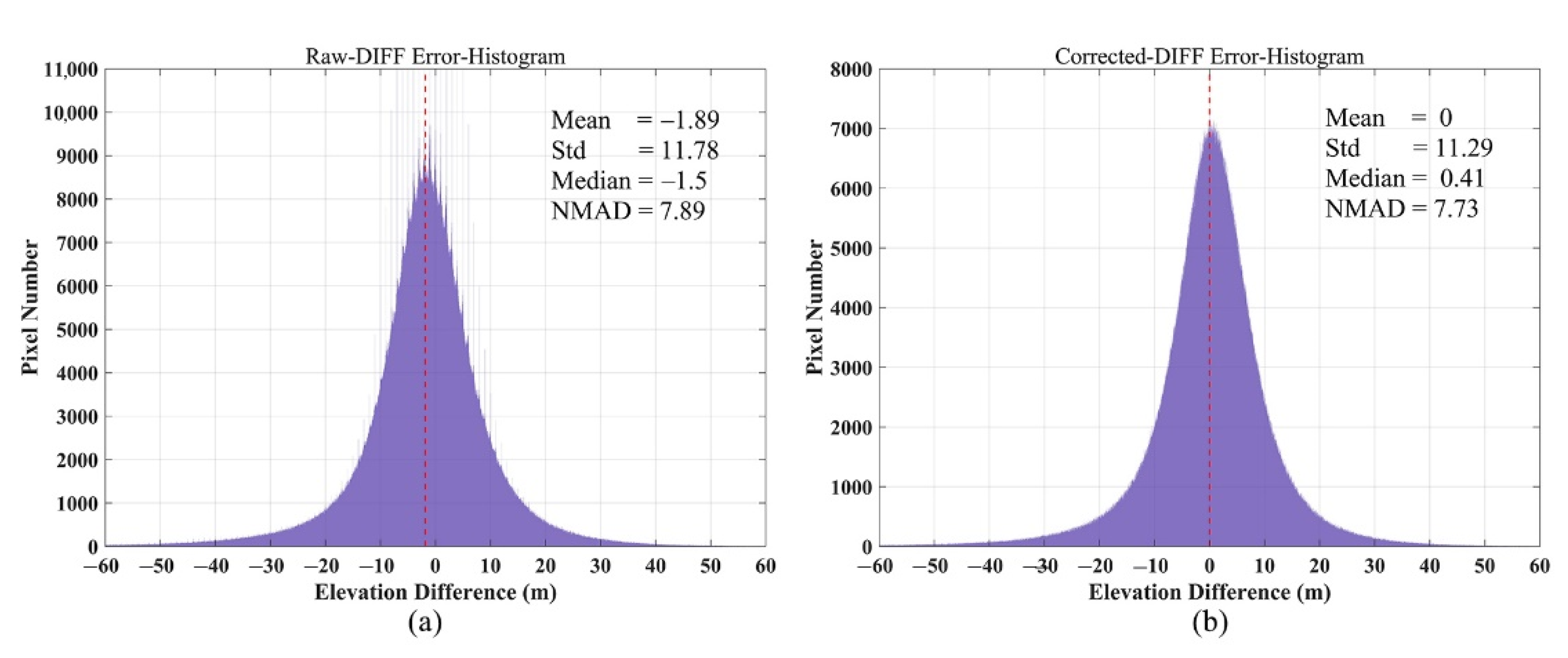
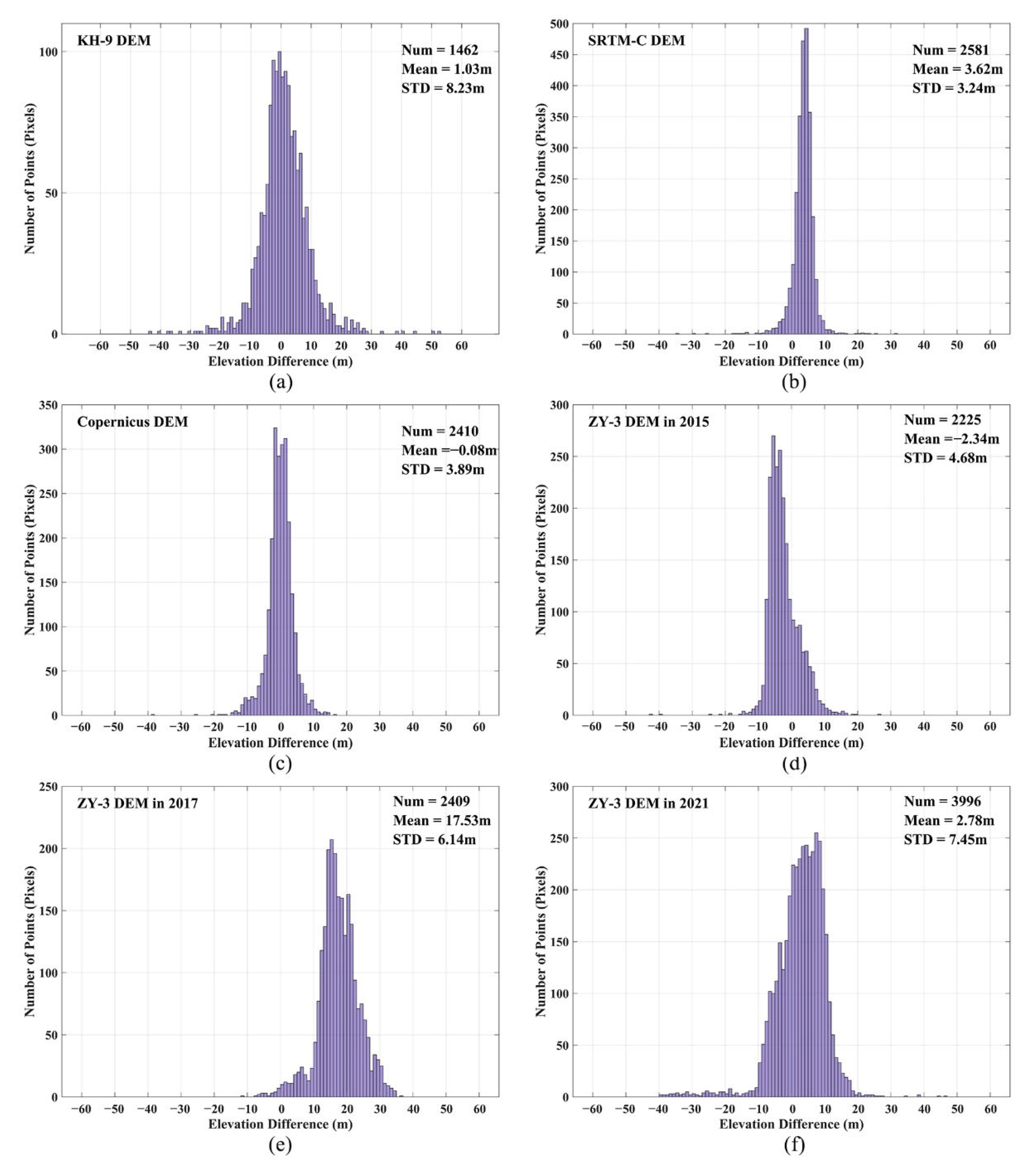
5.1. Assessment of DEM Accuracy
5.2. Comparison to Previous Studies
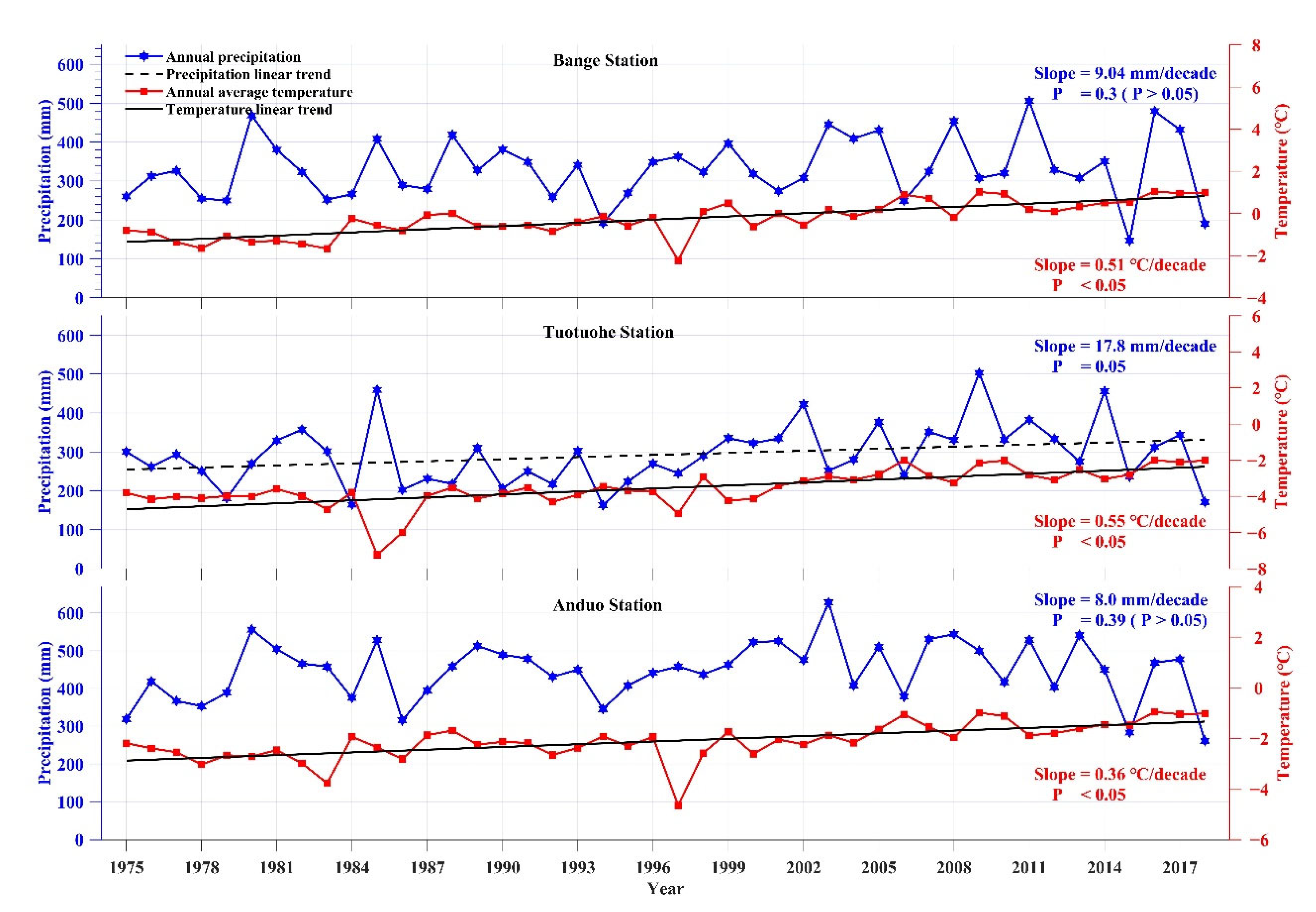
5.3. Potential Impacts of Climate Change on Glacier Changes in the Puruogangri Ice Field
6. Conclusions
Author Contributions
Funding
Data Availability Statement
Acknowledgments
Conflicts of Interest
References
- Bolch, T.; Kulkarni, A.; Kääb, A.; Huggel, C.; Paul, F.; Cogley, J.G.; Frey, H.; Kargel, J.S.; Fujita, K.; Scheel, M.; et al. The state and fate of himalayan glaciers. Science 2012, 336, 310–314. [Google Scholar] [CrossRef] [PubMed] [Green Version]
- Shean, D.E.; Bhushan, S.; Montesano, P.; Rounce, D.R.; Arendt, A.; Osmanoglu, B. A systematic, regional assessment of high mountain asia glacier mass balance. Front. Earth Sci. 2020, 7, 363. [Google Scholar] [CrossRef] [Green Version]
- Cao, B.; Guan, W.; Li, K.; Wen, Z.; Han, H.; Pan, B. Area and mass changes of glaciers in the west kunlun mountains based on the analysis of multi-temporal remote sensing images and dems from 1970 to 2018. Remote Sens. 2020, 12, 2632. [Google Scholar] [CrossRef]
- Yang, J.; Li, M.; Yang, S.; Tan, C. Vulnerability of the glaciers to climate change in china:Current situation and evaluation. J. Glaciol. Geocryol. 2013, 35, 1077–1087. [Google Scholar]
- Yao, T.; Wu, G.; Xu, B.; Wang, W.; Gao, J.; An, B. Asian water tower change and its impacts. Bull. Chin. Acad. Sci. 2019, 34, 1203–1209. [Google Scholar]
- Gao, J.; Yao, T.; Masson-Delmotte, V.; Steen-Larsen, H.C.; Wang, W. Collapsing Glaciers Threaten Asia’s Water Supplies; Nature Publishing Group: Beijing, China, 2019. [Google Scholar]
- Jacob, T.; Wahr, J.; Pfeffer, W.T.; Swenson, S. Recent contributions of glaciers and ice caps to sea level rise. Nature 2012, 482, 514–518. [Google Scholar] [CrossRef]
- Zhou, Y.; Li, X.; Zheng, D.; Li, Z.; An, B.; Wang, Y.; Jiang, D.; Su, J.; Cao, B. The joint driving effects of climate and weather changes caused the chamoli glacier-rock avalanche in the high altitudes of the india himalaya. Sci. China Earth Sci. 2021, 64, 1909–1921. [Google Scholar] [CrossRef]
- Kääb, A.; Leinss, S.; Gilbert, A.; Bühler, Y.; Gascoin, S.; Evans, S.G.; Bartelt, P.; Berthier, E.; Brun, F.; Chao, W.-A. Massive collapse of two glaciers in western tibet in 2016 after surge-like instability. Nat. Geosci. 2018, 11, 114–120. [Google Scholar] [CrossRef] [Green Version]
- Wang, Y.; Li, J.; Wu, L.; Guo, L.; Hu, J.; Zhang, X. Estimating the changes in glaciers and glacial lakes in the xixabangma massif, central himalayas, between 1974 and 2018 from multisource remote sensing data. Remote Sens. 2021, 13, 3903. [Google Scholar] [CrossRef]
- Veh, G.; Korup, O.; von Specht, S.; Roessner, S.; Walz, A. Unchanged frequency of moraine-dammed glacial lake outburst floods in the himalaya. Nat. Clim. Change 2019, 9, 379–383. [Google Scholar] [CrossRef]
- Zhou, Y.; Hu, J.; Li, Z.; Li, J.; Zhao, R.; Ding, X. Quantifying glacier mass change and its contribution to lake growths in central kunlun during 2000–2015 from multi-source remote sensing data. J. Hydrol. 2019, 570, 38–50. [Google Scholar] [CrossRef]
- Zhou, Y.; Li, Z.; Li, J.I.A. Slight glacier mass loss in the karakoram region during the 1970s to 2000 revealed by kh-9 images and srtm dem. J. Glaciol. 2017, 63, 331–342. [Google Scholar] [CrossRef] [Green Version]
- Zhou, Y.; Li, Z.; Li, J.I.A.; Zhao, R.; Ding, X. Geodetic glacier mass balance (1975–1999) in the central pamir using the srtm dem and kh-9 imagery. J. Glaciol. 2019, 65, 309–320. [Google Scholar] [CrossRef] [Green Version]
- Wang, N.; Yao, T.; Xu, B.; Chen, A.A.; Wang, W. Spatiotemporal pattern, trend, and influence of glacier change in tibetan plateau and surroundings under global warming. Bull. Chin. Acad. Sci. 2019, 34, 1220–1232. [Google Scholar]
- Zhang, J.; He, X.; Ye, B.; Wu, J. Recent variation of mass balance of the xiao dongkemadi glacier in the tanggula range and its influencing factors. J. Glaciol. Geocryol. 2013, 35, 263–271. [Google Scholar]
- The surface flow features of the puruogangri ice field. J. Glaciol. Geocryol. 2003, 25, 288–290.
- Kumar, A.; Negi, H.S.; Kumar, K.; Shekhar, C.; Kanda, N. Quantifying mass balance of east-karakoram glaciers using geodetic technique. Polar Sci. 2019, 19, 24–39. [Google Scholar] [CrossRef]
- Gardelle, J.; Berthier, E.; Arnaud, Y.; Kääb, A. Region-wide glacier mass balances over the pamir-karakoram-himalaya during 1999–2011. Cryosphere 2013, 7, 1263–1286. [Google Scholar] [CrossRef] [Green Version]
- Hugonnet, R.; McNabb, R.; Berthier, E.; Menounos, B.; Nuth, C.; Girod, L.; Farinotti, D.; Huss, M.; Dussaillant, I.; Brun, F.; et al. Accelerated global glacier mass loss in the early twenty-first century. Nature 2021, 592, 726–731. [Google Scholar] [CrossRef]
- Liu, L.; Jiang, L.; Jiang, H.; Wang, H.; Ma, N.; Xu, H. Accelerated glacier mass loss (2011–2016) over the puruogangri ice field in the inner tibetan plateau revealed by bistatic insar measurements. Remote Sens. Environ. 2019, 231, 111241. [Google Scholar] [CrossRef]
- Zhou, W.; Li, Z.; Li, J.; Cui, Z.; Wang, C. Variations of glaciers and glacial lake in geladandong mountain range in 1992–2009 with remote-sensing technology. J. Cent. South Univ. 2014, 2014, 45. [Google Scholar]
- Ye, Q.; Kang, S.; Chen, F.; Wang, J. Monitoring glacier variations on geladandong mountain, central tibetan plateau, from 1969 to 2002 using remote-sensing and gis technologies. J. Glaciol. 2006, 52, 537–545. [Google Scholar] [CrossRef] [Green Version]
- Berthier, E.; Brun, F. Karakoram geodetic glacier mass balances between 2008 and 2016: Persistence of the anomaly and influence of a large rock avalanche on siachen glacier. J. Glaciol. 2019, 65, 494–507. [Google Scholar] [CrossRef] [Green Version]
- Zhang, Z.; Jiang, L.; Liu, L.; Sun, Y.; Wang, H. Annual glacier-wide mass balance (2000–2016) of the interior tibetan plateau reconstructed from modis albedo products. Remote Sens. 2018, 10, 1031. [Google Scholar] [CrossRef] [Green Version]
- Zhou, Y.; Li, Z.; Li, J.; Zhao, R.; Ding, X. Glacier mass balance in the qinghai–tibet plateau and its surroundings from the mid-1970s to 2000 based on hexagon kh-9 and srtm dems. Remote Sens. Environ. 2018, 210, 96–112. [Google Scholar] [CrossRef]
- Liu, G.; Fan, J.-h.; Zhao, F.; Mao, K.-b. Monitoring elevation change of glaciers on geladandong mountain using tandem-x sar interferometry. J. Mt. Sci. 2017, 14, 859–869. [Google Scholar] [CrossRef]
- Huintjes, E.; Neckel, N.; Hochschild, V.; Schneider, C. Surface energy and mass balance at purogangri ice cap, central tibetan plateau, 2001–2011. J. Glaciol. 2015, 61, 1048–1060. [Google Scholar] [CrossRef] [Green Version]
- Neckel, N.; Braun, A.; Kropáček, J.; Hochschild, V. Recent mass balance of the purogangri ice cap, central tibetan plateau, by means of differential x-band sar interferometry. Cryosphere 2013, 7, 1623–1633. [Google Scholar] [CrossRef] [Green Version]
- Liu, L.; Jiang, L.; Sun, Y.; Wang, H.; Yi, C.; Hsu, H. Morphometric controls on glacier mass balance of the puruogangri ice field, central tibetan plateau. Water 2016, 8, 496. [Google Scholar] [CrossRef] [Green Version]
- Thompson, L.G.; Tandong, Y.; Davis, M.E.; Mosley-Thompson, E.; Mashiotta, T.A.; Lin, P.-N.; Mikhalenko, V.N.; Zagorodnov, V.S. Holocene climate variability archived in the puruogangri ice cap on the central tibetan plateau. Ann. Glaciol. 2006, 43, 61–69. [Google Scholar] [CrossRef] [Green Version]
- Maurer, J.; Rupper, S. Tapping into the hexagon spy imagery database: A new automated pipeline for geomorphic change detection. ISPRS J. Photogramm. Remote Sens. 2015, 108, 113–127. [Google Scholar] [CrossRef]
- Surazakov, A.; Aizen, V. Positional accuracy evaluation of declassified hexagon kh-9 mapping camera imagery. Photogramm. Eng. Remote Sens. 2010, 76, 603–608. [Google Scholar] [CrossRef] [Green Version]
- Dong, Y.; Chen, W.; Chang, H.; Zhang, Y.; Feng, R.; Meng, L. Assessment of orthoimage and dem derived from zy-3 stereo image in northeastern china. Surv. Rev. 2016, 48, 247–257. [Google Scholar] [CrossRef]
- Hasegawa, H.; Matsuo, K.; Koarai, M.; Watanabe, N.; Fukushima, Y. Dem accuracy and the base to height (b/h) ratio of stereo images. Int. Arch. Photogramm. Remote Sens. 2000, 33, 356–359. [Google Scholar]
- Farr, T.G.; Rosen, P.A.; Caro, E.; Crippen, R.; Duren, R.; Hensley, S.; Kobrick, M.; Paller, M.; Rodriguez, E.; Roth, L.; et al. The shuttle radar topography mission. Rev. Geophys. 2007, 45. [Google Scholar] [CrossRef] [Green Version]
- Rabus, B.; Eineder, M.; Roth, A.; Bamler, R. The shuttle radar topography mission—A new class of digital elevation models acquired by spaceborne radar. ISPRS J. Photogramm. Remote Sens. 2003, 57, 241–262. [Google Scholar] [CrossRef]
- AIRBUS. Copernicus Dem: Copernicus Digital Elevation Model Product Handbook; AIRBUS: Leiden, The Netherlands, 2020. [Google Scholar]
- Karlson, M.; Bastviken, D.; Reese, H. Error characteristics of pan-arctic digital elevation models and elevation derivatives in northern sweden. Remote Sens. 2021, 13, 4653. [Google Scholar] [CrossRef]
- Purinton, B.; Bookhagen, B. Beyond vertical point accuracy: Assessing inter-pixel consistency in 30 m global dems for the arid central andes. Front. Earth Sci. 2021, 9, 758606. [Google Scholar] [CrossRef]
- Brosens, L.; Campforts, B.; Govers, G.; Aldana-Jague, E.; Razanamahandry, V.F.; Razafimbelo, T.; Rafolisy, T.; Jacobs, L. Comparative analysis of the copernicus, tandem-x, and uav-sfm digital elevation models to estimate lavaka (gully) volumes and mobilization rates in the lake alaotra region (madagascar). Earth Surf. Dynam. 2022, 10, 209–227. [Google Scholar] [CrossRef]
- Round, V.; Leinss, S.; Huss, M.; Haemmig, C.; Hajnsek, I. Surge dynamics and lake outbursts of kyagar glacier, karakoram. Cryosphere 2017, 11, 723–739. [Google Scholar] [CrossRef] [Green Version]
- Lambrecht, A.; Mayer, C.; Wendt, A.; Floricioiu, D.; VÖLksen, C. Elevation change of fedchenko glacier, pamir mountains, from gnss field measurements and tandem-x elevation models, with a focus on the upper glacier. J. Glaciol. 2018, 64, 637–648. [Google Scholar] [CrossRef] [Green Version]
- Marešová, J.; Gdulová, K.; Pracná, P.; Moravec, D.; Gábor, L.; Prošek, J.; Barták, V.; Moudrý, V. Applicability of data acquisition characteristics to the identification of local artefacts in global digital elevation models: Comparison of the copernicus and tandem-x dems. Remote Sens. 2021, 13, 3931. [Google Scholar] [CrossRef]
- Yan, L.; Wang, J.; Shao, D. Glacier mass balance in the manas river using ascending and descending pass of sentinel 1a/1b data and srtm dem. Remote Sens. 2022, 14, 1506. [Google Scholar] [CrossRef]
- Zhao, F.; Long, D.; Li, X.; Huang, Q.; Han, P. Rapid glacier mass loss in the southeastern tibetan plateau since the year 2000 from satellite observations. Remote Sens. Environ. 2022, 270, 112853. [Google Scholar] [CrossRef]
- Kropáček, J.; Neckel, N.; Bauder, A. Estimation of mass balance of the grosser aletschgletscher, swiss alps, from icesat laser altimetry data and digital elevation models. Remote Sens. 2014, 6, 5614–5632. [Google Scholar] [CrossRef] [Green Version]
- Sochor, L.; Seehaus, T.; Braun, M.H. Increased ice thinning over svalbard measured by icesat/icesat-2 laser altimetry. Remote Sens. 2021, 13, 2089. [Google Scholar] [CrossRef]
- Kropáček, J.; Vařilová, Z.; Baroň, I.; Bhattacharya, A.; Eberle, J.; Hochschild, V. Remote sensing for characterisation and kinematic analysis of large slope failures: Debre sina landslide, main ethiopian rift escarpment. Remote Sens. 2015, 7, 16183–16203. [Google Scholar] [CrossRef] [Green Version]
- King, O.; Quincey, D.J.; Carrivick, J.L.; Rowan, A.V. Spatial variability in mass loss of glaciers in the everest region, central himalayas, between 2000 and 2015. Cryosphere 2017, 11, 407–426. [Google Scholar] [CrossRef] [Green Version]
- Robson, B.A.; Nuth, C.; Nielsen, P.R.; Girod, L.; Hendrickx, M.; Dahl, S.O. Spatial variability in patterns of glacier change across the manaslu range, central himalaya. Front. Earth Sci. 2018, 6, 12. [Google Scholar] [CrossRef] [Green Version]
- Pieczonka, T.; Bolch, T.; Junfeng, W.; Shiyin, L. Heterogeneous mass loss of glaciers in the aksu-tarim catchment (central tien shan) revealed by 1976 kh-9 hexagon and 2009 spot-5 stereo imagery. Remote Sens. Environ. 2013, 130, 233–244. [Google Scholar] [CrossRef] [Green Version]
- Zhou, Y.; Li, X.; Zheng, D.; Zhang, X.; Wang, Y.; Ren, S.; Guo, Y. Decadal changes in glacier area, surface elevation and mass balance for 2000–2020 in the eastern tanggula mountains using optical images and tandem-x radar data. Remote Sens. 2022, 14, 506. [Google Scholar] [CrossRef]
- Li, C.; Jiang, L.; Liu, L.; Wang, H. Regional and altitude-dependent estimate of the srtm c/x-band radar penetration difference on high mountain asia glaciers. IEEE J. Sel. Top. Appl. Earth Obs. Remote Sens. 2021, 14, 4244–4253. [Google Scholar] [CrossRef]
- Nuth, C.; Kääb, A. Co-registration and bias corrections of satellite elevation data sets for quantifying glacier thickness change. Cryosphere 2011, 5, 271–290. [Google Scholar] [CrossRef] [Green Version]
- Bolch, T.; Pieczonka, T.; Benn, D.I. Multi-decadal mass loss of glaciers in the everest area (nepal himalaya) derived from stereo imagery. Cryosphere 2011, 5, 349–358. [Google Scholar] [CrossRef] [Green Version]
- Huss, M. Density assumptions for converting geodetic glacier volume change to mass change. Cryosphere 2013, 7, 877–887. [Google Scholar] [CrossRef] [Green Version]
- Zhang, X.; Zhou, J.; Liu, Z. Dem extraction and precision evaluation of mountain glaciers in the qianghai-tibet plateau based on kh-9 data: Take the purog kangri glacier and the jiong glacier as example. J. Glaciol. Geocryol. 2019, 41, 27–35. [Google Scholar]
- Lei, Y.; Yao, T.; Yi, C.; Wang, W.; Sheng, Y.; Li, J.; Joswiak, D. Glacier mass loss induced the rapid growth of linggo co on the central tibetan plateau. J. Glaciol. 2012, 58, 177–184. [Google Scholar] [CrossRef] [Green Version]
- Liu, L.; Jiang, L.; Sun, Y.; Yi, C.; Wang, H.; Hsu, H. Glacier elevation changes (2012–2016) of the puruogangri ice field on the tibetan plateau derived from bi-temporal tandem-x insar data. Int. J. Remote Sens. 2016, 37, 5687–5707. [Google Scholar] [CrossRef]


| Data | Acquisition Date | Resolution | Purpose |
|---|---|---|---|
| Landsat 5/TM | 7 November 2000 | 30 m | Glacier boundary delineation for 2000 |
| Landsat 7/ETM+ | 29 September 2012 | Pan: 15 m | Glacier boundary delineation for 2012 |
| Landsat 8/OLI | 30 September 2015 21 October 2017 17 November 2021 | Pan: 15 m | Glacier boundary delineation for 2015, 2017 and 2021 |
| KH-9 Image | 20 December 1975 | 6–9 m | Glacier boundary delineation and DEM extraction for 1975 |
| ZY-3 Stereo Images | 30 December 2015 15 November 2017 24 November 2021 | NAD: 2.1 m; DLC: 3.5 m | DEM extraction for 2015, 2017 and 2021 |
| SRTM DEMs (C- and X-bands) | ~ February 2000 | 30 m | DEM acquisition for 2000 and estimation of penetration depth for C-band radar |
| Copernicus DSM | ~July 2012 | 30 m | DEM acquisition for 2012 |
| ICESat-1/GLAH14 | 2003–2009 | ~70 m | DEM accuracy assessment |
| Meteorological Data | 1975–2018 | Station | Climate change analysis |
| Glacier (GLIMS_ID) | Glacier Area (km2) | |||||
|---|---|---|---|---|---|---|
| 1975 | 2000 | 2012 | 2015 | 2017 | 2021 | |
| Puruogangri Ice Field | 427.44 ± 12.43 | 406.78 ± 11.65 | 399.70 ± 11.38 | 392.56 ± 11.11 | 387.08 ± 11.20 | 387.87 ± 11.02 |
| G94 | 50.13 ± 0.65 | 48.87 ± 0.62 | 47.65 ± 0.62 | 47.34 ± 0.62 | 46.86 ± 0.61 | 46.67 ± 0.61 |
| G37 | 43.86 ± 0.81 | 40.03 ± 0.75 | 37.62 ± 0.73 | 37.42 ± 0.77 | 37.07 ± 0.76 | 36.99 ± 0.75 |
| G36 | 13.11 ± 0.30 | 12.38 ± 0.29 | 11.54 ± 0.27 | 11.49 ± 0.26 | 11.35 ± 0.26 | 11.31 ± 0.25 |
| G05 | 14.28 ± 0.29 | 14.09 ± 0.29 | 14.50 ± 0.31 | 14.62 ± 0.31 | 14.42 ± 0.31 | 14.40 ± 0.31 |
| G13 | 9.06 ± 0.24 | 8.57 ± 0.23 | 8.42 ± 0.23 | 8.40 ± 0.19 | 8.27 ± 0.23 | 8.59 ± 0.24 |
| G98 | 30.43 ± 0.67 | 29.93 ± 0.61 | 25.90 ± 0.60 | 25.25 ± 0.54 | 24.57 ± 0.64 | 25.91 ± 0.63 |
| Research | Data | Period | Result |
|---|---|---|---|
| Lei et al. [59] | Topographic maps and SRTM DEMs | 1974–2000 | −0.20 m w.e. a−1 a |
| Huintjes et al. [28] | High Asia Refined analysis (HAR) dataset | 2000–2011 | −0.038 m w.e. a−1 b |
| Neckel et al. [29] | SRTM-X and TanDEM-X DEMs | 2000–2012 | −0. 044 ± 0.002 m w.e. a−1 |
| Liu et al. [30] | SRTM-X and TanDEM-X DEMs | 2000–2012 | −0.035 to +0.019 m w.e. a−1 |
| Liu et al. [60] | TanDEM-X DEMs | 2012–2016 | −0.317 ± 0.027 m w.e. a−1 |
| Liu et al. [21] | TanDEM-X DEMs | 2011–2016 | 0.44 ± 0.10 m w.e. a−1 over 2011–2012 −0.13 ± 0.03 m w.e. a−1 over 2012–2013 −0.34 ± 0.06 m w.e. a−1 over 2013–2014 −0.52 ± 0.10 m w.e. a−1 over 2014–2016 |
Publisher’s Note: MDPI stays neutral with regard to jurisdictional claims in published maps and institutional affiliations. |
© 2022 by the authors. Licensee MDPI, Basel, Switzerland. This article is an open access article distributed under the terms and conditions of the Creative Commons Attribution (CC BY) license (https://creativecommons.org/licenses/by/4.0/).
Share and Cite
Ren, S.; Li, X.; Wang, Y.; Zheng, D.; Jiang, D.; Nian, Y.; Zhou, Y. Multitemporal Glacier Mass Balance and Area Changes in the Puruogangri Ice Field during 1975–2021 Based on Multisource Satellite Observations. Remote Sens. 2022, 14, 4078. https://doi.org/10.3390/rs14164078
Ren S, Li X, Wang Y, Zheng D, Jiang D, Nian Y, Zhou Y. Multitemporal Glacier Mass Balance and Area Changes in the Puruogangri Ice Field during 1975–2021 Based on Multisource Satellite Observations. Remote Sensing. 2022; 14(16):4078. https://doi.org/10.3390/rs14164078
Chicago/Turabian StyleRen, Shanshan, Xin Li, Yingzheng Wang, Donghai Zheng, Decai Jiang, Yanyun Nian, and Yushan Zhou. 2022. "Multitemporal Glacier Mass Balance and Area Changes in the Puruogangri Ice Field during 1975–2021 Based on Multisource Satellite Observations" Remote Sensing 14, no. 16: 4078. https://doi.org/10.3390/rs14164078
APA StyleRen, S., Li, X., Wang, Y., Zheng, D., Jiang, D., Nian, Y., & Zhou, Y. (2022). Multitemporal Glacier Mass Balance and Area Changes in the Puruogangri Ice Field during 1975–2021 Based on Multisource Satellite Observations. Remote Sensing, 14(16), 4078. https://doi.org/10.3390/rs14164078


