Article

Automated Filtering of Multibeam Water-Column Data to Detect Relative Abundance of Giant Kelp (Macrocystis pyrifera)

by
Alexandre C. G. Schimel
1,2,*,
Craig J. Brown
3 and
Daniel Ierodiaconou
2
1
National Institute of Water and Atmospheric Research (NIWA), Greta Point, Wellington 6021, New Zealand
2
School of Life and Environmental Sciences, Centre for Integrative Ecology, Deakin University, Warrnambool 3280, VIC, Australia
3
Department of Oceanography, Dalhousie University, Halifax, Nova Scotia B3H 4R2, Canada
*
Author to whom correspondence should be addressed.
Remote Sens. 2020, 12(9), 1371; https://doi.org/10.3390/rs12091371
Submission received: 7 March 2020 / Revised: 20 April 2020 / Accepted: 25 April 2020 / Published: 26 April 2020
(This article belongs to the Section Ocean Remote Sensing)

Abstract

:
Modern multibeam echosounders can record backscatter data returned from the water above the seafloor. These water-column data can potentially be used to detect and map aquatic vegetation such as kelp, and thus contribute to improving marine habitat mapping. However, the strong sidelobe interference noise that typically contaminates water-column data is a major obstacle to the detection of targets lying close to the seabed, such as aquatic vegetation. This article presents an algorithm to filter the noise and artefacts due to interference from the sidelobes of the receive array by normalizing the slant-range signal in each ping. To evaluate the potential of the filtered data for the detection of aquatic vegetation, we acquired a comprehensive water-column dataset over a controlled experimental site. The experimental site was a transplanted patch of giant kelp (Macrocystis pyrifera) forest of known biomass and spatial configuration, obtained by harvesting several individuals from a nearby forest, measuring and weighing them, and arranging them manually on an area of seafloor previously bare. The water-column dataset was acquired with a Kongsberg EM 2040 C multibeam echosounder at several frequencies (200, 300, and 400 kHz) and pulse lengths (25, 50, and 100 μs). The data acquisition process was repeated after removing half of the plants, to simulate a thinner forest. The giant kelp plants produced evident echoes in the water-column data at all settings. The slant-range signal normalization filter greatly improved the visual quality of the data, but the filtered data may under-represent the true amount of acoustic energy in the water column. Nonetheless, the overall acoustic backscatter measured after filtering was significantly lower, by 2 to 4 dB on average, for data acquired over the thinned forest compared to the original experiment. We discuss the implications of these results for the potential use of multibeam echosounder water-column data in marine habitat mapping.

Graphical Abstract

1. Introduction

After several decades of technological development, multibeam echosounders (MBES) have become a standard remote-sensing tool with which to map seafloor bathymetry [1]. These systems are also popular for their additional capability to record the strength of the echo returned from the seafloor (usually termed “backscatter”), which is strongly dependent on seafloor type and structure, and can thus be used to infer seafloor geology, geomorphology, and habitats [2]. Modern MBES have the capability to record a third data type: the strength of the echo returned from the section of water column travelled by the transmitted pulse before it reaches the seafloor. These commonly termed “water-column data” have already shown much potential in a range of marine applications, including the detection and study of gas seeps, suspended sediments, or fish schools [3]. Another possible application of MBES water-column data is the detection and mapping of underwater vegetation extending substantially from the seabed, such as kelp.
Beds of kelp (Laminariales order) are important ecological communities in temperate waters globally, usually supporting high biodiversity as the large plants provide food, shelter, and prey opportunities to a wide range of species [4,5,6]. Dramatic shifts in ecosystem structure and the communities they support can occur when kelp is lost extensively [7], which occur under a range of species-dependent factors. For example, giant kelp (Macrocystis spp.) is highly sensitive to major storms [8], rise in water temperature [9], or outbreaks of sea urchin populations [5]. In Australia, the coverage and range of giant kelp forests have undergone an extensive decline since the earliest studies in the 1950s, with major loss episodes linked to strong El Niño events and the increasing southerly penetration of the warm waters of the Eastern Australian Current [10]. Techniques to rapidly and reliably map the distribution of kelp communities are necessary in order to detect change in coverage or density that would be indicative of ecosystem health issues.
Where the kelp canopy is visible from the air, that is, in very shallow waters or for kelp species whose canopy reaches the surface such as giant kelp and bull kelp (Nereocystis luetkeana), this is often best achieved with optical or multispectral remote sensing systems borne by satellites [11,12,13,14], planes [11,15], or drones [16]. However, where kelp lie too deep in the water column for these methods, surveying is still mostly carried out with diver or underwater camera transects [17], which achieve less spatial coverage [18]. Kelp may also be surveyed with underwater acoustic systems as the plants produce recognizable echoes in acoustic data acquired with high-frequency sounders. Single-beam and split-beam echosounders operating at 120 kHz or 200 kHz have been used to detect the presence of kelp [19], measure its canopy height [20], or map its distribution [21,22,23,24]. The availability of strict but practical calibration protocols [25], standard data processing methods [26], and laboratory measurements of acoustic properties of kelp [27,28,29,30] may even allow using these systems to estimate kelp biomass. However, these systems have a limited angular aperture (usually of the order of 1–10°), which results in a very limited spatial coverage. This is in stark contrast to MBES technology, which typically records several hundreds of beams over a very wide aperture (120° or more), allowing high-resolution imaging of the water column over a wide swath along the track of the vessel.
This coverage advantage has inspired research in developing methods to detect and map aquatic vegetation with MBES data, using either bathymetry [31,32] or seafloor backscatter [33]. Increasingly, maps of marine habitats, including kelp-dominated habitats, are being developed from machine learning models that use both sources of MBES data, as well as derivatives, and are trained on ground-truthed locations [34,35,36,37]. Since some habitats are dominated by aquatic vegetation that extend into the water column, the addition to these models of features derived from MBES water-column data could potentially improve the capability to differentiate these community types.
However, MBES water-column data are difficult to exploit because they are characteristically noisy. There are many different sources of potential noise [38], but the most problematic is arguably the sidelobes in the beam patterns of the transmit and receive arrays, which are inherent to the sonar design. The beam pattern of a sonar array is not perfectly directional. While the bulk of the acoustic ensonification/sensitivity is in a single direction within a narrow angular aperture as per design (i.e., the main lobe of the beam), some ensonification/sensitivity remains in other directions (i.e., sidelobes) [39]. As a result, strong acoustic targets lying in these other directions may produce echoes that the system will record and display as if this energy had been transmitted and received within the main lobe [38]. For hydrographic MBES installed in the traditional “Mills cross” configuration, interference from sidelobes in transmission and in reception produce characteristically different artefacts, with the former producing along-track “frown-shaped” artefacts and the latter producing across-track “smile-shaped” artefacts [38].
Across-track artefacts due to the sidelobes in reception picking up the seafloor echo are arguably the main challenge to the exploitation of MBES water-column data because they are always present, even in the absence of targets in the water column. The so-called “specular” artefact is the most conspicuous. It affects, for any given ping, all beams at approximately the slant range of the closest bottom return (usually termed “minimum slant range”), and is due to the sidelobes picking up the strong specular reflection of the transmit pulse on that part of the seabed that is directly facing the sonar [38]. The strong noise that contaminates all samples between the specular artefact and the bottom echo is also due to interference from sidelobes of the receive array, in this case picking up the seafloor backscatter echo. Although less strong than the specular artefact, this noise greatly hinders the detection of water-column targets located close to the bottom and away from nadir [3].
Because of this inherent noise, the application of MBES water-column data for the detection of aquatic vegetation and the estimation of their presence, abundance, or canopy height has remained scarce to date. The possibility to detect and map aquatic vegetation in MBES water-column data have been explored [33,40,41,42], but these studies’ analyses were limited to the central beams, which are the only ones where the region immediately above the seafloor is not affected by reception sidelobes interference. This approach essentially eliminates the unique wide-swath advantage of MBES since it reduces the analysis coverage to an extent roughly equivalent to that of a single-beam or split-beam echosounder. To realize the full potential of MBES water-column data for the detection, characterization, and quantification of aquatic vegetation or other targets near the seafloor, it is necessary to overcome the issue posed by reception sidelobes interference, for example, by developing data processing methodologies to efficiently filter the noise.
In this article, we present an algorithm to attempt filtering noise and artefacts due to reception sidelobes interference by normalizing the slant-range signal in each ping. To test its efficiency and assess if water-column data can then be used to detect differences in kelp density for habitat mapping, we acquired data over a transplanted patch of giant kelp with known biomass and spatial configuration, representing a dense and sparse kelp coverage. Giant kelp was chosen here due to its large size, which makes it an ideal practice target for method development. Water-column data were acquired for a range of frequencies and pulse lengths in order to evaluate the importance of those settings on the efficiency of the filtering algorithm.

2. Materials and Methods

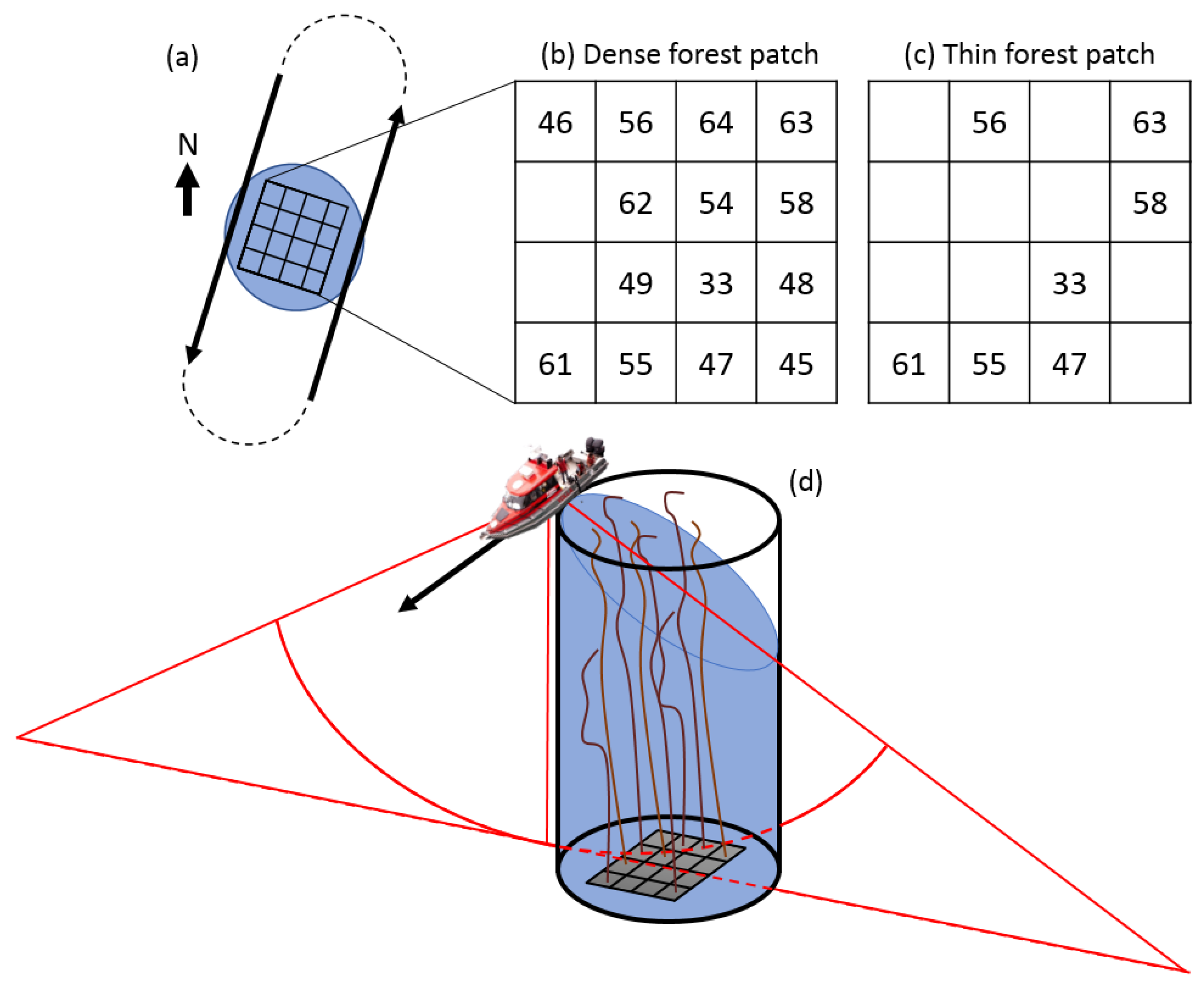
We harvested 16 plants from a giant kelp forest located on a rocky reef off the Hopkins River mouth near Warrnambool, Victoria, Australia (38.405°S 142.503°E). Isolated individuals were selected to ensure the forest’s continuous surface canopy was not affected. The plants were brought to port, tagged, measured, and weighed while still wet (Figure 1a and Table 1), and then transported to the test site. The test site comprised of a flat, coarse sand seabed with no visible biota, approximately 11 m deep. A 4 × 4 m quadrat was set up on the seafloor by SCUBA divers using ropes delineating 1 m wide square cells. The divers bagged the holdfast of each plant with sand and weights and placed each bag at a random location in one of the 16 cells within the quadrat, leaving the rest of the plant floating freely in the water column (Figure 1b,c). Unfortunately, two plants remained positively buoyant despite the bagging and were swept away by the current before they could be fixed. The remaining 14 plants remained in the quadrat, thus simulating a “dense forest patch” with a density of 0.88 plants per m2 and total weight biomass of 209.3 kg (Table 1 and Figure 2b). Later in the experiment, the divers removed half of the plants at random, thus simulating a “thin forest patch” with a density of 0.44 plants per m2 and biomass of 105.8 kg (Table 1 and Figure 2c).
Water-column data were acquired over the experiment site using a Kongsberg EM 2040 C MBES fitted on Deakin University’s research vessel Yolla. First, we acquired the data over the dense forest patch by running the vessel three times on two parallel paths with opposite directions on either side of the surface canopy (Figure 2a) using three frequencies (200, 300, and 400 kHz) and three pulse lengths (25 μs or “very short”, 50 μs or “short”, and 100 μs or “medium” continuous waveform (CW) pulses). These 3 replicates in 2 directions of data recorded with 9 different settings resulted in 54 data files. The vessel speed was maintained as constant as possible at 4–5 knots. All other settings for the sonar system and its ancillary sensors (positioning/motion sensor) were kept constant and at standard values for surveying, as described in previous research using this equipment [37,43,44]. The same procedure was followed for the thin forest patch, leading to another set of 54 data files. All files acquired are available for download (see Supplementary Materials).
Giant kelp naturally grows on rocky reefs, which have a very different bathymetry profile, roughness, and acoustic impedance than the flat, sandy seafloor of this experiment. To ensure that our data processing algorithms are also suitable outside of our controlled experiment, we also acquired several data files over natural patches of giant kelp forest found on the rocky reef where our plants were harvested.
MATLAB code was developed to process the MBES water-column data records, extending a toolbox created during previous research [45] and available for download [46]. Using this code, the water-column data and the necessary ancillary information (ping time; vessel position, roll, pitch, and heading; beam steering angle, etc.) were extracted from the MBES raw data files and geometrically processed to obtain the position of each water-column data sample in the swath space (distances upwards and towards starboard, with origin at the sonar head) and in projected coordinates (UTM 54 zone South easting and northing, and height above the ellipsoid). The bottom detection information was extracted and geometrically processed in the same way. Since all data acquisition for this experiment occurred in a single small location, in a short space of time, and at constant settings (besides the controlled frequency and pulse length), we made no efforts at this stage to apply to the backscatter level the radiometric corrections that would be necessary to ensure consistency over depth and time. We kept the level of each sample as found in the records, that is, the “sample amplitude in 0.5 dB resolution” found in the water-column datagrams [47].
Reception sidelobes interference intrinsically affects all beams at a constant slant range. This characteristic can be exploited. We wrote an algorithm implementing a slant-range signal normalization (SRSN) to essentially reduce the level at all ranges to a comparable level. In any single ping, the algorithm calculates the average level across all beams for every range and subtracts it from the level of all samples at the corresponding range. Then, the algorithm adds a reference level calculated as the average level of all samples of the 11 most central beams above the seabed. The following equation describes the SRSN algorithm:
B S f ( P , B , S ) = B S o ( P , B , S ) 1 N B b = 1 N B B S o ( P , b , S ) + 1 11 N S ( P ) s = 1 N S ( P ) b = N B / 2 5 N B / 2 5 B S o ( P , b , s )
where B S o ( P , B , S ) and B S f ( P , B , S ) are, respectively, the original and filtered backscatter level for ping P, beam B, and sample S; N B is the total number of beams (240 in our system); and N S ( P ) is the sample number corresponding to the bottom detect for the central beam N B / 2 in ping P.
For display and analysis, the data filtered after application of the SRSN algorithm were gridded at a 10 cm resolution in all three projected dimensions (easting, northing, height). This allowed extracting horizontal “slices” of the filtered dataset at set depths.
To attempt quantifying the overall acoustic energy returned from the kelp forest patch, we measured the average backscatter level (both before and after the application of the SRSN algorithm) within the target volume, defined as the geographically right cylinder centred on the middle of the patch (629565.2 m easting, 5748648.4 m northing), with a horizontal radius of 3 m and a vertical extent bounded at the bottom by the seafloor and at the top by the sonar depth (Figure 2d). This measurement had to be controlled for two confounding factors.
First, the patterns of the various artefacts in water-column data imply that the average acoustic energy recorded in the water column is likely to increase with across-track distance away from nadir. Therefore, the average backscatter level measured in the target volume may depend on how far from the patch the data were acquired. To control for this, we calculated for each data file the shortest horizontal distance between the sonar’s horizontal location and the centre of the patch (henceforth, “shortest horizontal distance to the patch”).
Second, the target volume could never be entirely insonified because of the limited angular aperture of the swath (Figure 2d). In fact, the percentage of the target volume actually insonified was different in any given data file depending on the vessel’s roll movement, the transmit beam aperture (which depends on the operational frequency), and proximity to the patch of the vessel during transit along the survey line. To control for this, for each data file we calculated the percentage of the target volume that had been effectively insonified using the ratio between the number of 3D grid cells within the target volume that contained data and the total number of 3D grid cells theoretically composing the target volume.

3. Results

3.1. Water-column Data Examples and Effects of the SRSN Filter

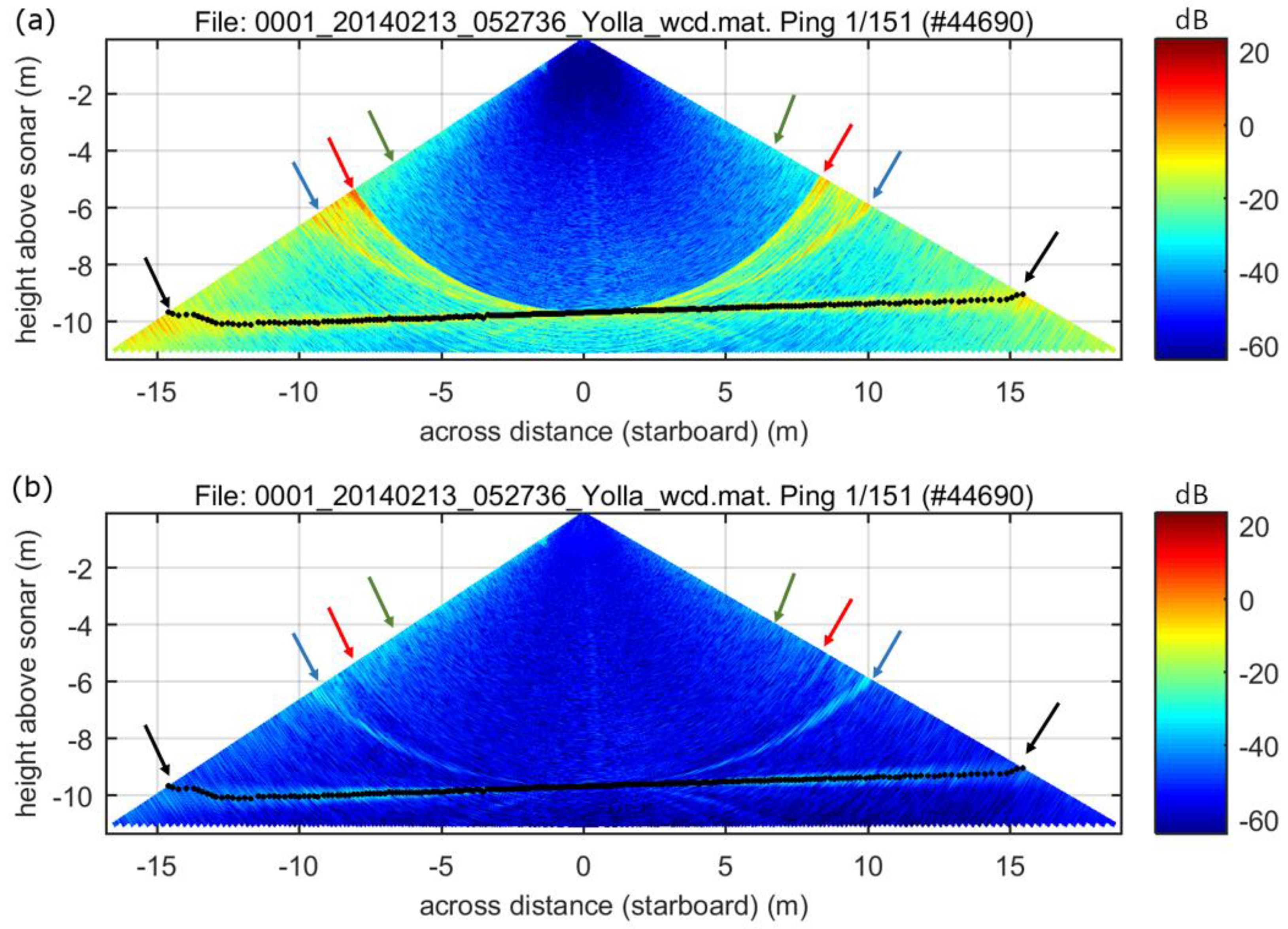
Figure 3a shows the first ping of the first data file acquired (300 kHz and 25 μs “very short” CW pulse) as an illustration of the various types of noise affecting our dataset in the absence of targets in the water column. In this vertical section of water column across the path of the vessel, the only pattern that represents an actual feature is the seafloor echo, which appears as an almost horizontal echo with a relatively strong level (between −10 dB and 0 dB) approximately 9.5 m deep below the sonar (black arrows in Figure 3a). All other patterns on the figure are not due to real targets but acoustic noise. The most clearly visible of these artefacts is a single specular artefact, which shows as a relatively strong echo (between −10 dB and 0 dB) that characteristically affects all beams at a constant slant range (approximately 9.5 m in this example) corresponding to a part of the seafloor that directly faces the sonar (red arrows in Figure 3a). Several specular artefacts can be found in MBES water-column data with a complex bathymetric profile, but in simple seafloor profiles such as here, a single specular artefact is found at a slant range corresponding to the minimum slant range. At shorter ranges, our water-column data are relatively free of noise (overall level lower than −50 dB), while at longer ranges, they display a higher and more variable background noise due to reception sidelobes interference (level ranging between −60 dB and −20 dB). In this region, just beyond the specular artefact, is an unidentified artefact showing as a relatively strong echo (between −10 dB and 0 dB) that occurs at a range increasing with beam steering direction away from nadir (blue arrows in Figure 3a). A particularly strong sidelobe pointing in a constant angle direction away from the acoustic axis (grating lobe) is ruled out as a cause because this would normally result as a linear echo tangential to the specular artefact (see [38] for examples). This artefact may be specific to the design of the system’s receive array, but its origin remains unexplained to date. Finally, a last visible artefact in our data is that outer beams display a higher backscatter level than inner beams, perhaps due to outer receive beams having a larger aperture or to a decrease in sensitivity of the transmit beam at these larger angles (green arrows in Figure 3a).
Figure 3b shows the result of the SRSN filter on this water-column data ping record. The algorithm successfully removed the strong specular artefact but also normalized the regions before and after the closest bottom return range to the same overall level. However, the unidentified artefact and the outer beam artefacts (respectively, blue and green arrows in Figure 3b) were not compensated, as they do not occur at constant slant ranges.
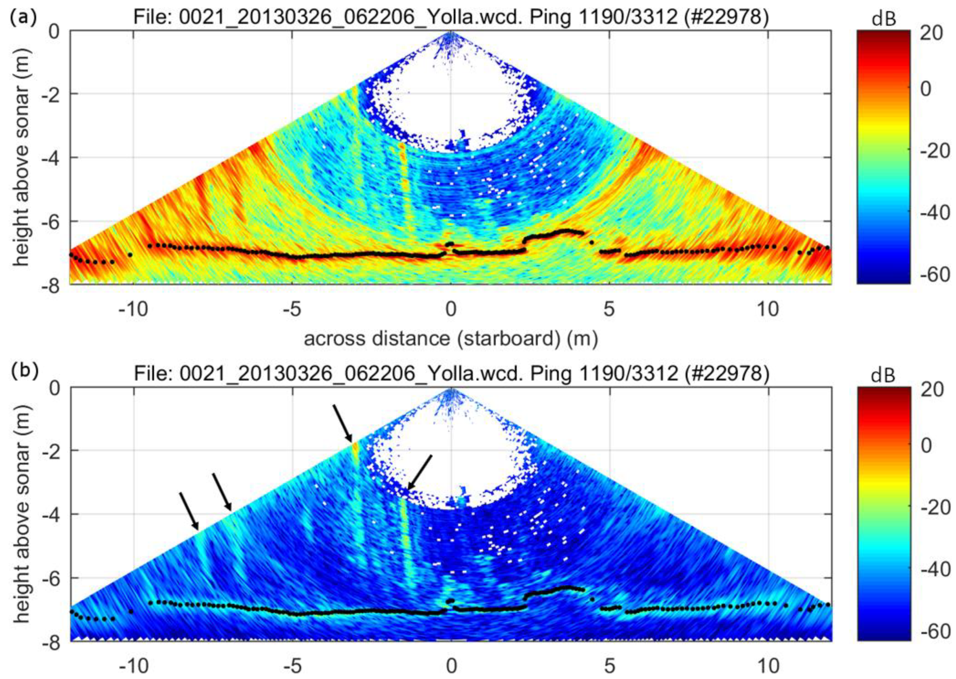
Figure 4 shows an example of the result of the application of the SRSN filter with targets present in the water column, in this case, giant kelp plants in a natural setting (300 kHz and 50 μs “short” CW pulse). The backscattering of the pulse by giant kelp plants produces near-vertical, high-intensity echoes extending from the seafloor through the water column. These strong mid-water echoes also result in more specular artefacts than in the previous example, as does the more complex bathymetry profile. The SRSN filter normalized the data across ranges, resulting in removing all artefacts due to reception sidelobes interference, irrespective of their origin (Figure 4). However, the removal of these artefacts did not reveal any overlapping echo from giant kelp.
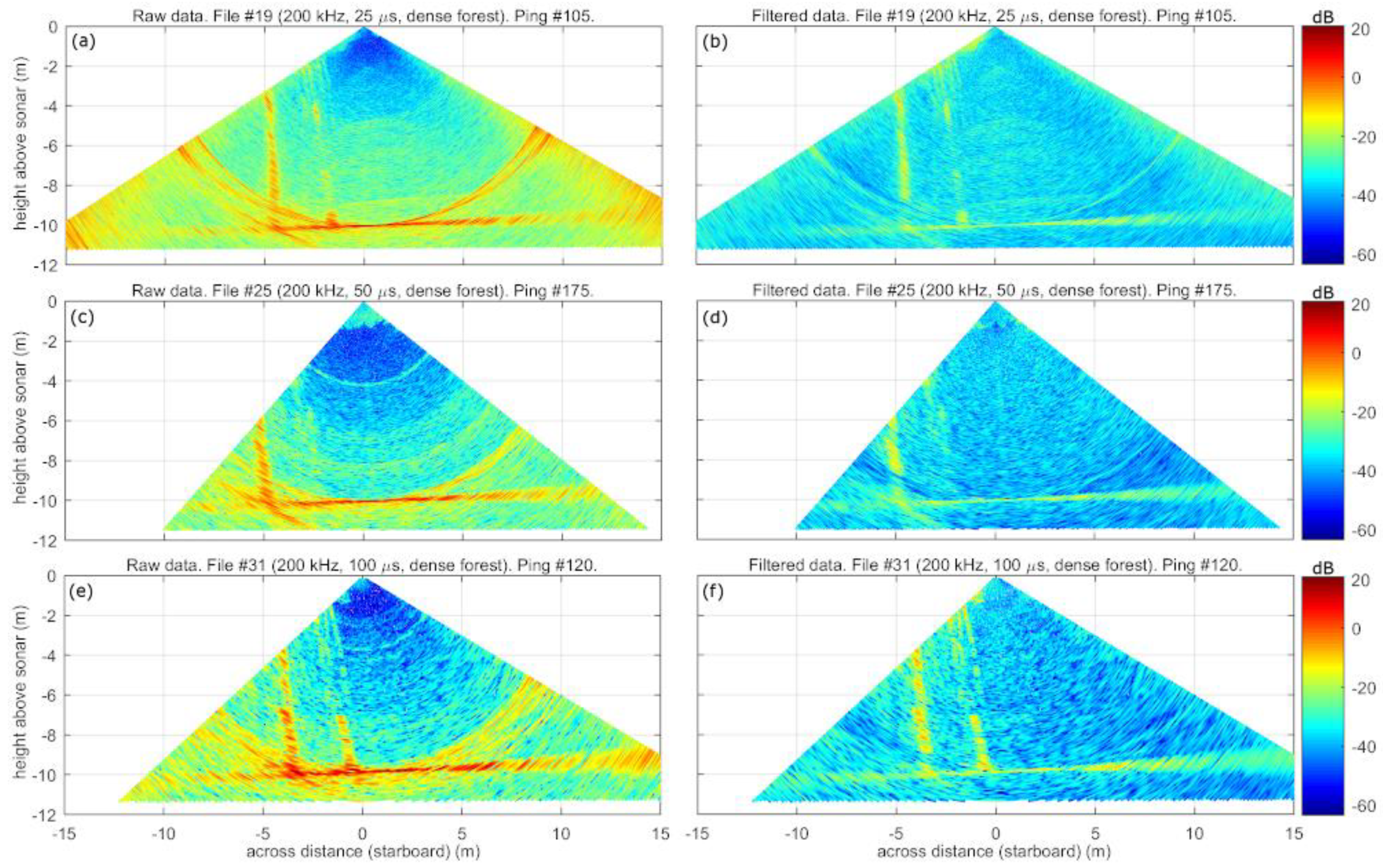
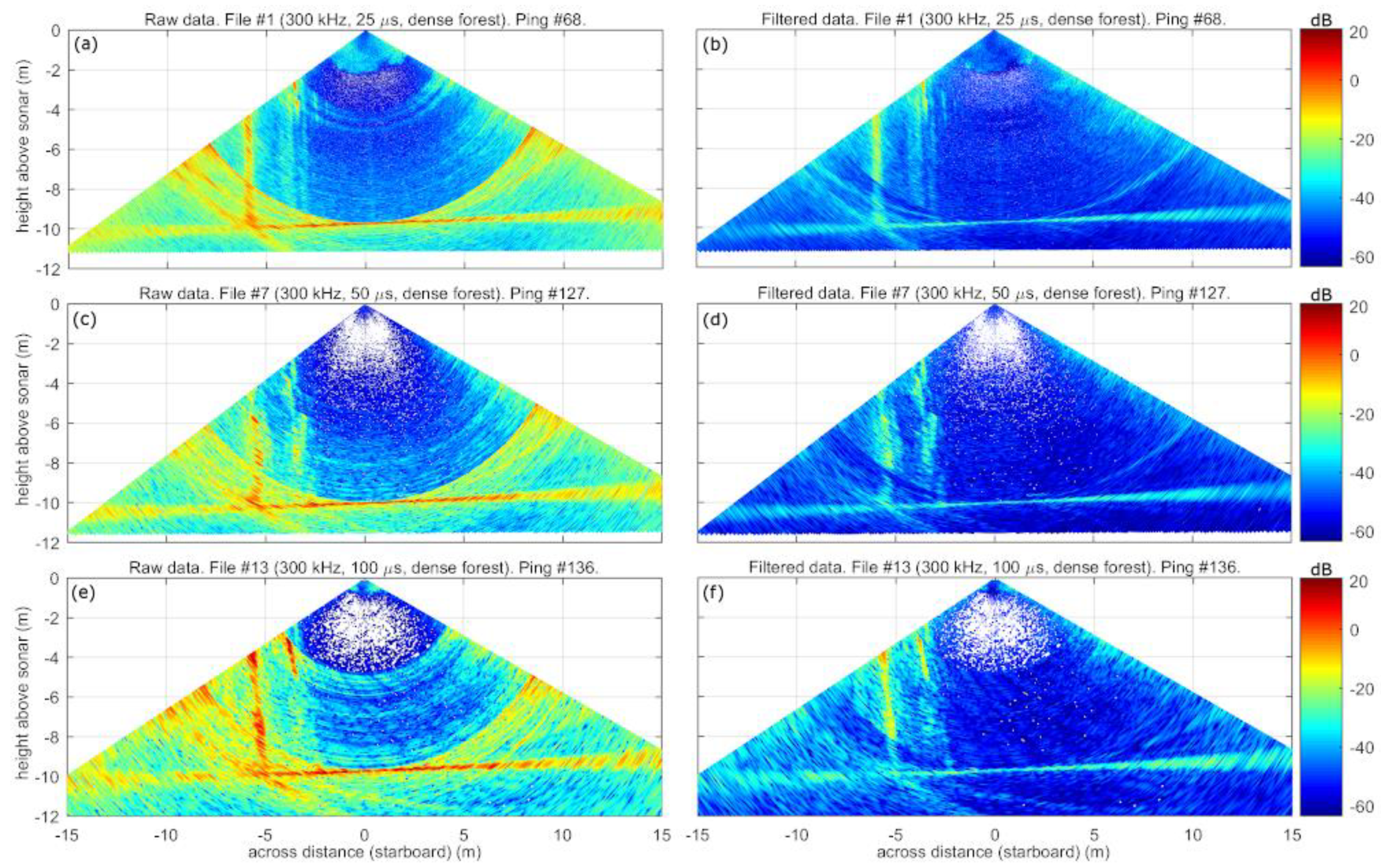
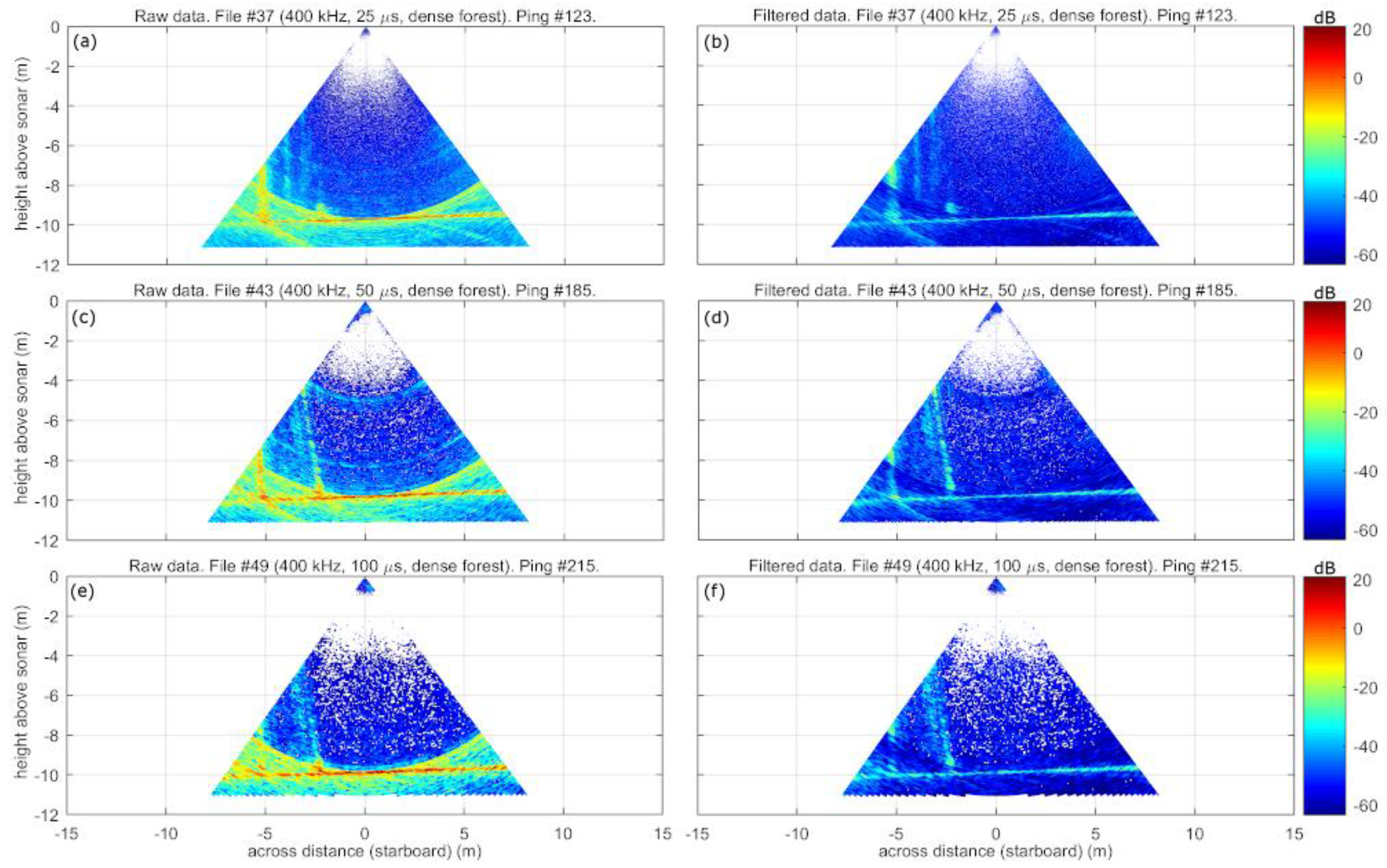
Figure 5, Figure 6 and Figure 7 show examples of MBES water-column data acquired over the dense forest patch at, respectively, 200, 300, and 400 kHz. The giant kelp echoes are always present, but their appearance varies with both frequency and pulse length. The image detail gets increasingly finer with higher frequency and shorter pulse lengths. In addition, water-column data acquired at 400 kHz show a much narrower transmit angular aperture (Figure 7). In each of these three figures, the left panels show data before application of the SRSN filter, and the right panels after application. The SRSN filter appears to successfully remove all artefacts due to reception sidelobes interference, including those generated by the giant kelp plants themselves, but again does not reveal the signal where it overlapped with the artefact.

3.2. Comparing Dense Against Thin Patch Results in Horizontal Slice View

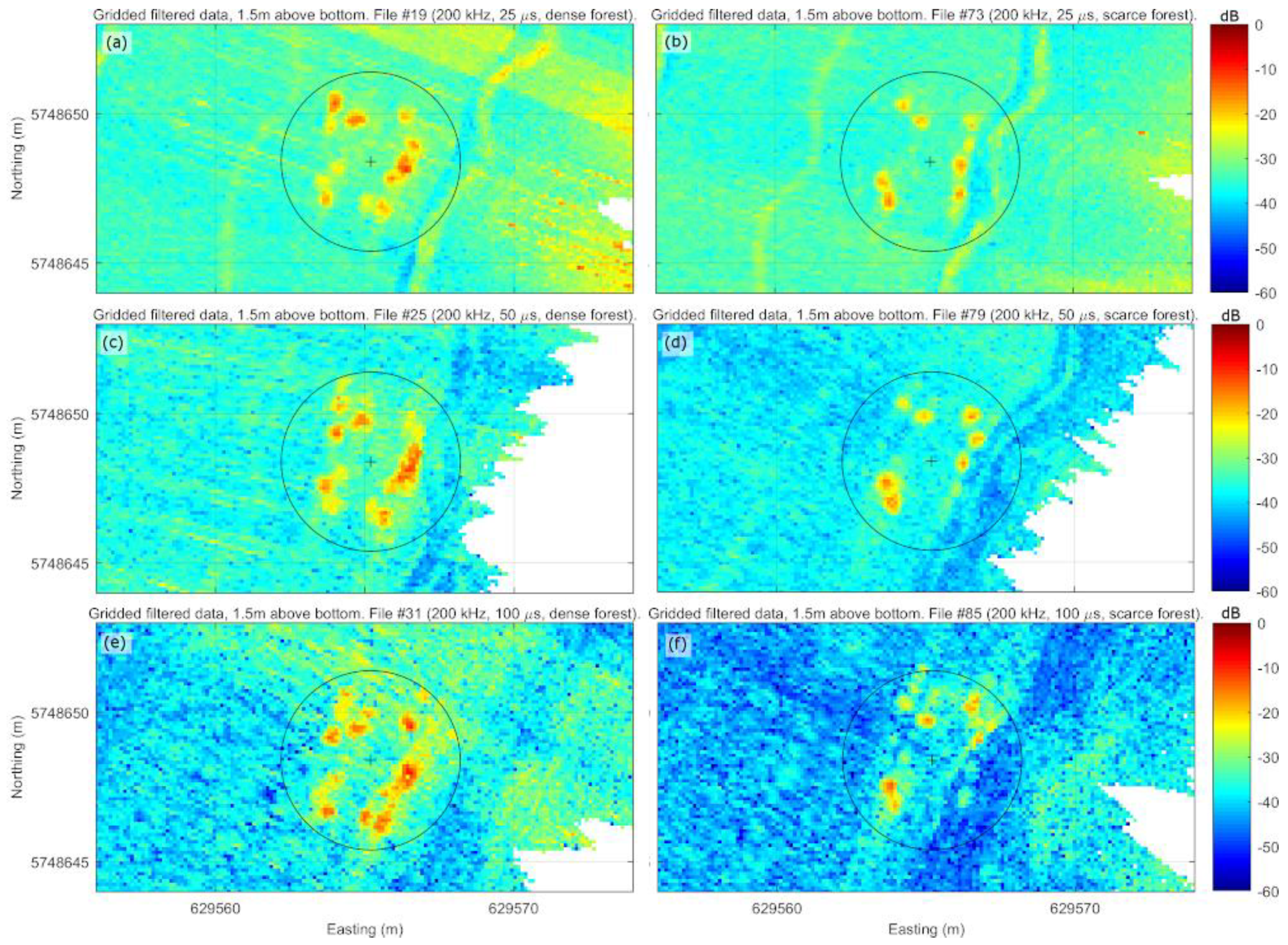
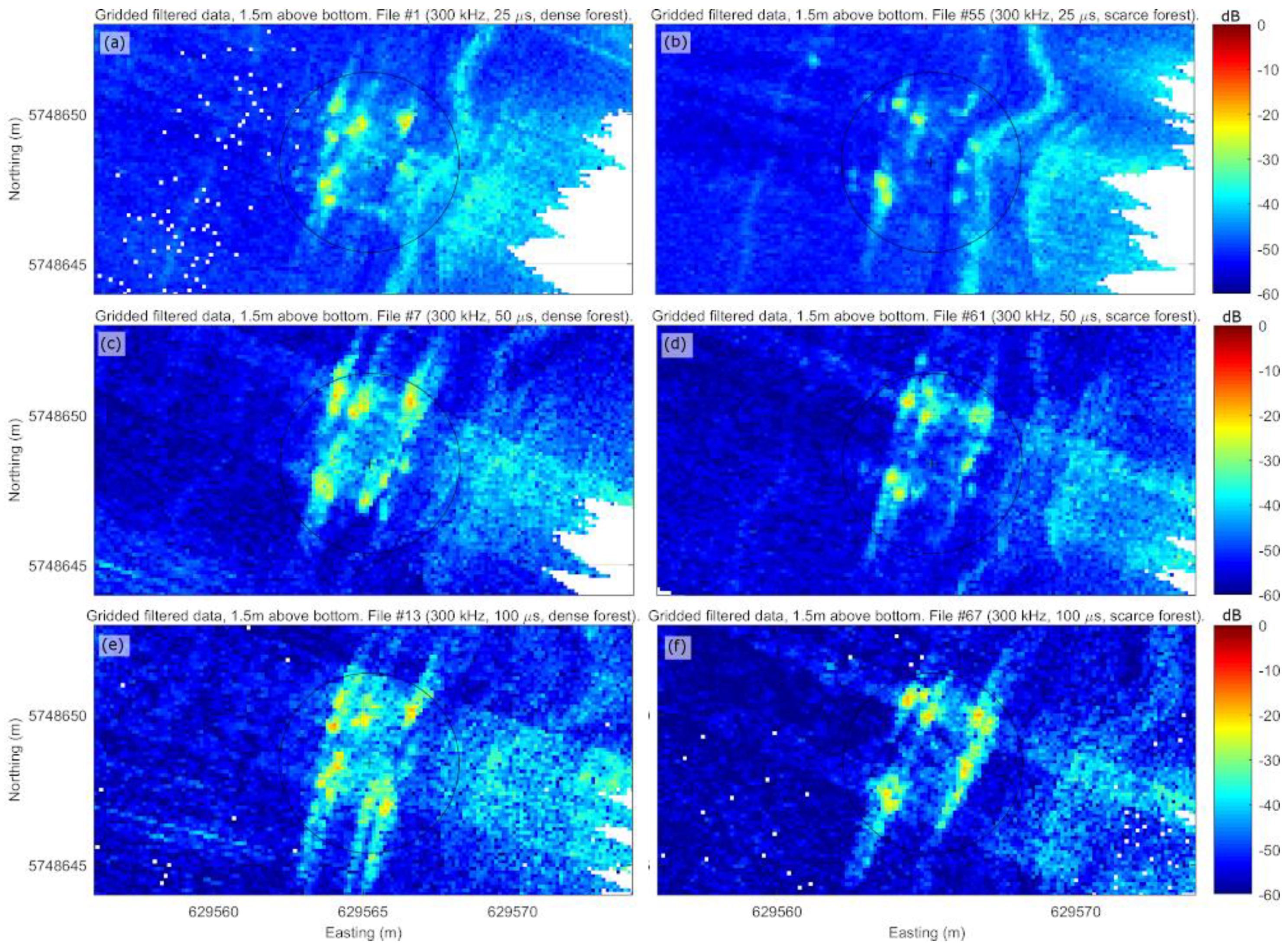
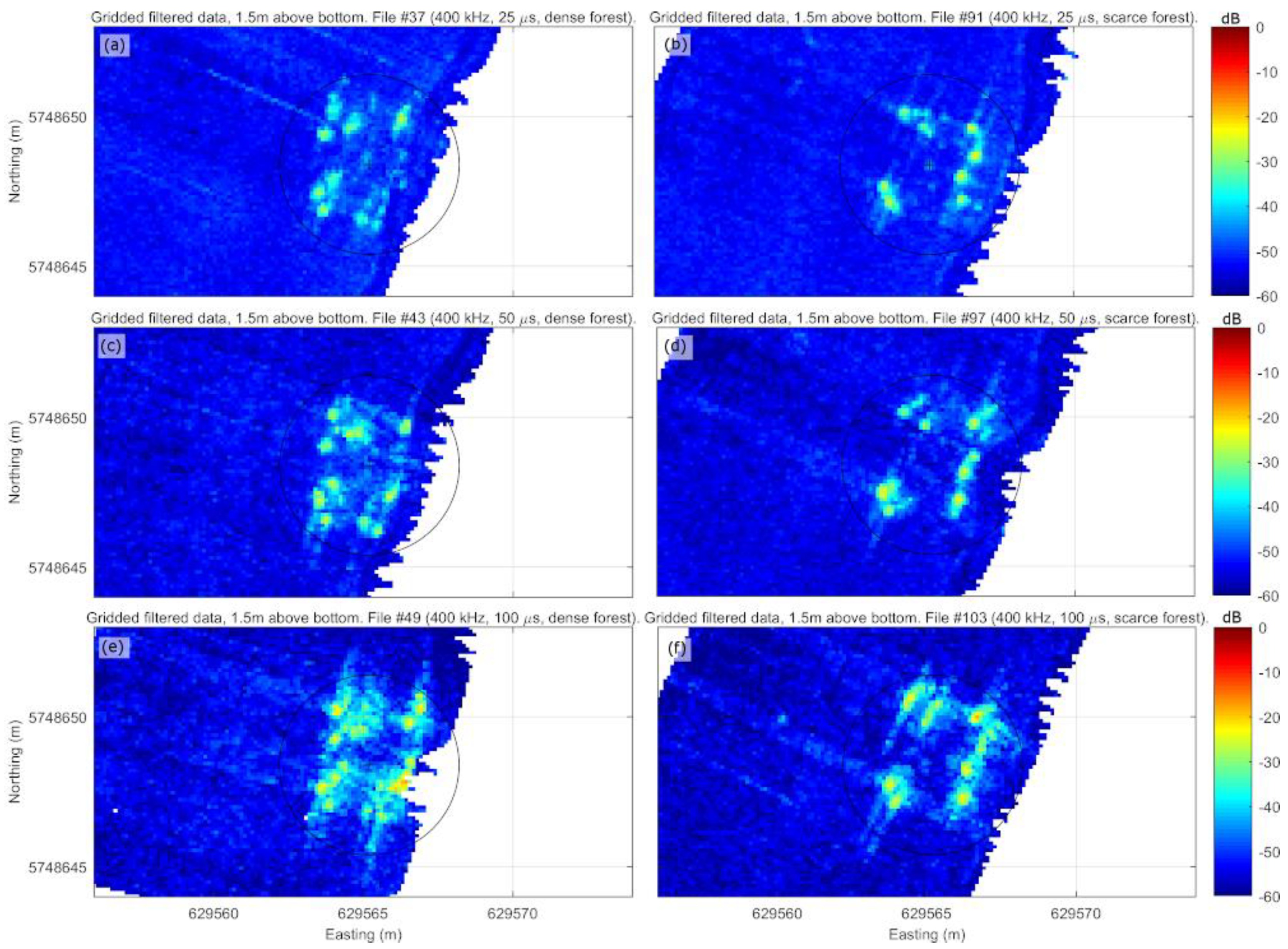
Figure 8, Figure 9 and Figure 10 show a horizontal slice of the filtered data after gridding (thus 10 cm in width), taken at 1.5 m above the seafloor, to illustrate the difference in echoes and energy returned between the dense forest patch (panels on the left) and the thin forest patch (panels on the right). Each figure displays the first file acquired for the three different pulse settings at a given frequency (respectively, 200, 300, and 400 kHz). The slices reveal the individual echoes of giant kelp plants, although in most settings, these echoes “smear” over the previous and subsequent pings due to along-track interference from the sidelobes of the transmit array [38,48]. For all settings, the thin forest patch showed fewer echoes than the dense one. However, there was no clear correspondence between the spatial arrangement of these echoes and the plants’ known locations (Figure 2). We assume this is due to the plants having shifted within their respective cells after installation.

3.3. Average Backscatter Level in Target Volume

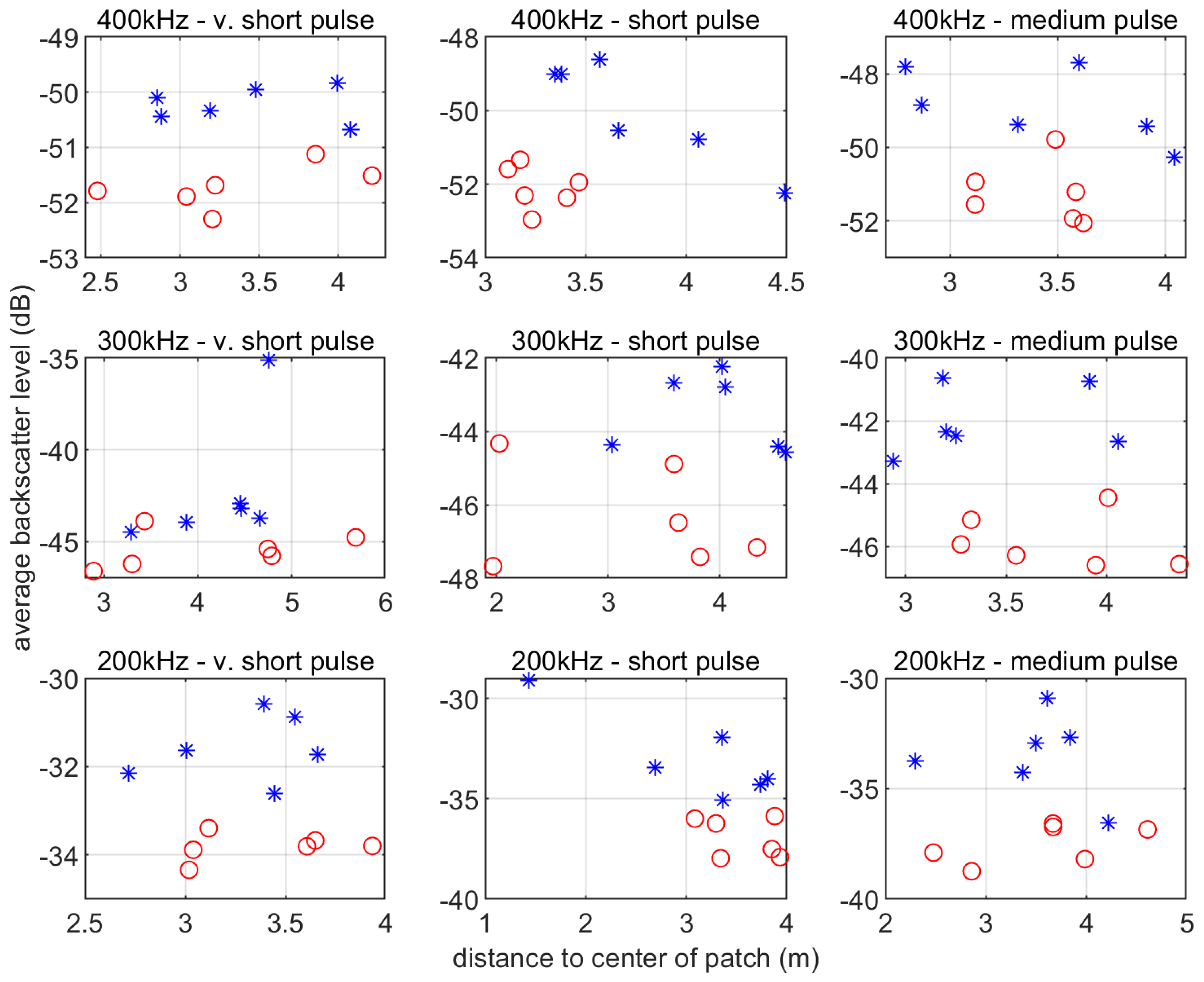
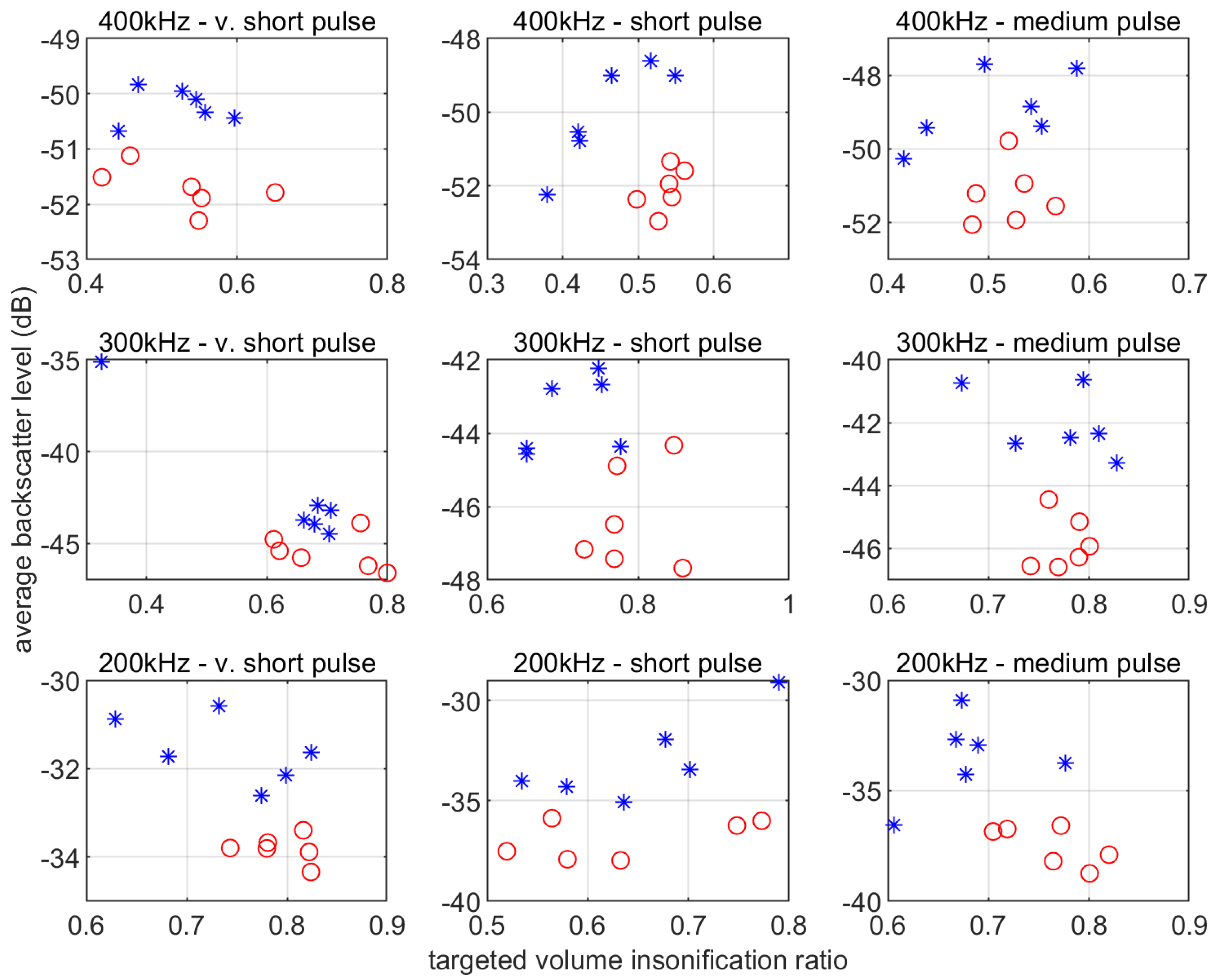
Figure 11 and Figure 12 show the average level of the filtered backscatter data calculated within the target volume for each combination of settings. The data are shown as a function of the shortest horizontal distance to the patch in Figure 11 and as a function of the ratio of the target volume insonified in Figure 12. There are not enough files per setting to produce conclusive regressions, but measured levels do not appear to depend on distance to the patch, indicating that the SRSN filter may be successful at compensating for this effect. Likewise, the results do not appear to depend on the target volume insonified.
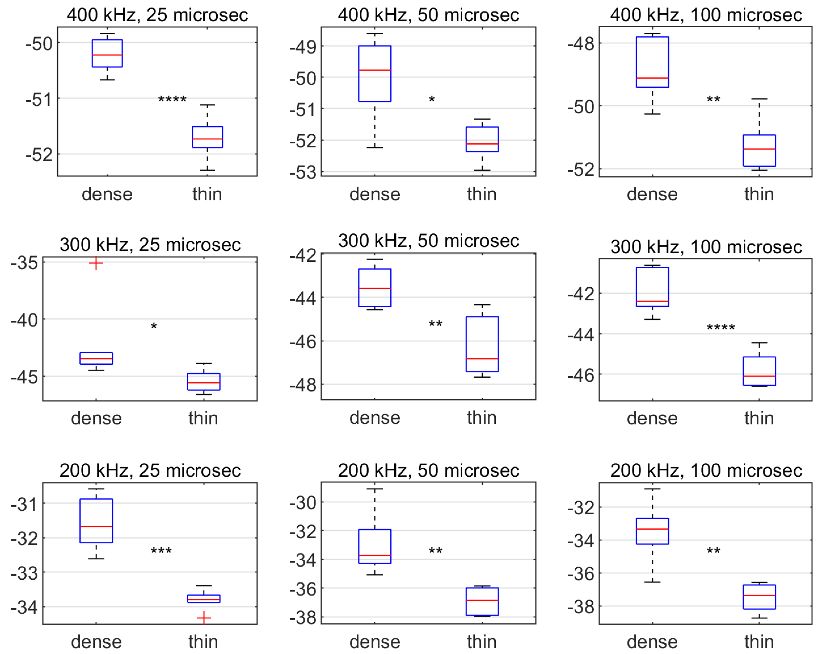
These results also show that the recorded average backscatter level always tends to be higher for the dense forest patch compared to the thin one. Figure 13 shows the same data collapsed into box plots and confirms the difference for all settings. Overall, we observed a significant difference of about 2 to 4 dB, which is a ratio of approximately half in natural intensity values.

4. Discussion

Previous studies have demonstrated that large species of kelp can be detected in the water-column data of commercial high-frequency MBES. Assemblages of large kelp of the Laminaria genus were thus detected using an Imagenex 837 Delta-T operating at 260 kHz [41,42] and a Reson Seabat 7125 operating at 400 kHz [33]. Our study supports these prior results, showing that giant kelp can be detected with a Kongsberg EM 2040 C operating at 200, 300, or 400 kHz. Moreover, there was a significant difference between the average backscatter levels measured over the dense and thin forest patch, at all frequencies. This difference was higher on average with lower frequency (~4 dB for 200 kHz vs. ~2 dB for 400 kHz), but this was compensated by the spread in values, which was lower for higher frequency (~2 dB for 200 kHz vs. ~1 dB for 400 kHz), so that the separability was equivalent across frequencies. These differences held across all pulse lengths tested.
These positive results obtained in a controlled experiment suggest the possible use of this approach to detect and map the presence of giant kelp in its natural environment, and perhaps even to discern broad patterns in abundance, whether in geographical distribution or change over time. However, to extrapolate from our controlled experiment to these applications would require additional controls on data acquisition and processing.
In terms of data acquisition, any survey would need to be undertaken at constant settings (number of sectors, frequency, pulse length, etc.). Modern MBES have the capability to automatically adjust settings (in particular, pulse length) to optimize bathymetry data acquisition. However, these changes impact the backscatter level. It is already common practice to turn off this dynamic capability in MBES surveys that are also undertaken for seafloor backscatter data acquisition to ensure consistency in the backscatter level acquired [2], and the same recommendation would apply for water-column data acquisition. The fact that our results were significant at all pulse lengths and frequencies tested would imply that there may be no need to compromise with possible settings requirements for bathymetry or seafloor backscatter data acquisition. However, the choice of frequency and pulse length affect transmit aperture, image resolution, and signal-to-noise ratio, and thus require due considerations in order to maximize detectability in natural settings.
First, the choice of pulse length constitutes a trade-off between image resolution and range: shorter pulses lead to improved image resolution (25, 50, and 100 μs CW pulses have theoretical target separability of approximately 1.9, 3.8, and 7.5 cm, respectively), while longer pulses have more energy and thus maintain a higher signal-to-noise ratio over longer ranges. Therefore, shorter pulses may be better suited for detecting individual plants within forests, while longer pulses may be better suited for detecting the forests’ overall backscatter over longer distances. In our results, the gain in image detail with short pulses was evident, but the gain in signal-to-noise ratio with longer pulses was not. This is quite likely because the ranges in our study were too short for this effect to be noticeable. However, surveys in larger and denser giant kelp forests may benefit from such higher signal-to-noise ratio to overcome acoustic shadowing.
Next, the choice of frequency constitutes a trade-off between angular coverage and noise. The highest source level is usually found in the middle of the bandwidth, but our results showed that the lowest background noise was found at higher frequencies. However, higher frequencies also resulted in lower angular coverage. The transmit beam aperture of the EM 2040 C is fixed at 130° for all frequencies between 200 and 320 kHz, then gradually decreases with increasing frequency until reaching 70° at the maximum frequency of 400 kHz [49]. For this system, 320 kHz may thus be the optimal choice to maximize angular coverage while minimizing background noise. For surveys, however, an even larger aperture would be preferable. As experienced in this research, the limited transmit aperture, combined with the necessity to steam the vessel around the canopy to avoid damaging it, implied that much of the plants in the upper part of the water column could not be imaged. In a natural giant kelp forest setting, individuals within large and dense forests may be out of reach altogether. Therefore, MBES surveys dedicated to mapping this species would require a wider aperture such as that in dual-head configurations, where each sonar head is mounted at an angle directed towards the starboard or port side. Note that with such wider aperture setups, the issue that most of the targets will be found beyond the minimum slant range (and thus in parts of the water-column data that are most affected by reception sidelobes interference) would still apply.
In terms of data processing, quantitative applications typically require retrieving an absolute backscatter level in order to allow inverting physical models. This is obtained by implementing a suitable radiometric correction including a field calibration offset. Commonly done with MBES seafloor backscatter data, a radiometric correction consists of removing the system’s time-varying gain (TVG) and, based on the sonar equation, introducing a more accurate compensation for the various factors that alter the signal along the data acquisition chain until retrieving a standard backscatter value [50]. Some important differences would need to be considered for radiometric correction of MBES water-column data, such as outputting the volumetric backscattering coefficient instead of its areal counterpart, and the effect of array focusing on the transmission losses. After radiometric correction, there often remains a residual offset due to the absence or inaccuracy of some critical information (e.g., source level, beam patterns, reported gains, etc.). This is usually fixed by complementing the radiometric correction with a field calibration, that is, to acquire data over a target of known target strength and compensate the system for the measured bias. Practical and standardized methods for calibration in the field are commonplace for fisheries (split-beam) echosounders but remain in development for MBES because the geometry of these systems (several hundred beams of very small aperture) makes it considerably more difficult [25].
Fortunately, an absolute backscatter level would not be a strict requirement for non-quantitative applications, such as creating a map of presence/absence, or a “heat map” of relative distribution, or as input to classification models. By comparison, MBES seafloor backscatter data have been successfully used for more than two decades to inform habitat maps, although these systems still lack a standard protocol for calibration of that data type [2]. Some data processing is, however, necessary for these applications. For example, mapping a given area with a single survey still requires that the backscatter level used is not dependent with depth, which is the case after application of our filter since the filter normalizes the signal across ranges. In addition, comparing data acquired at different times would require accounting for any drift of the system’s acoustic properties over time. Using a reference area to identify any offset would be required in this case.
Giant kelp was chosen in this study due to its large size, which made it an ideal practice target. However, most of the kelp biomass in Victoria, Australia, and other temperate coastlines is from smaller, more common species (e.g., Ecklonia radiata in Australia). The echoes for these smaller species will undoubtedly be more difficult to detect as they overlap with the seabed echo and the reception sidelobes interference beyond the minimum slant range. Further development will thus be needed to refine the data processing algorithms (e.g., [48]).
Sidelobe interference noise is an issue that is common to all potential applications of MBES water-column data. For example, they are a major hindrance for the detection and quantification of gas seeps, which are arguably the main research and commercial application of MBES water-column data to date [3]. Such targets are usually easier to detect than aquatic vegetation because they are much stronger acoustic reflectors and generally extend considerably in the water column, but reception sidelobes interference noise still obscures a significant portion of the data where gas seeps echoes can be found.
The pervasiveness of this class of noise has many unwelcome consequences that severely limit the usefulness and adoption of MBES water-column data to date. In particular, it restricts water-column data analysis approaches to mostly time-consuming manual interpretation, which presents a major operational challenge for larger surveys as well as introducing an element of human subjectivity that prevents the repeatability of interpretation (see [51]). The common approach of simply discarding all data beyond the minimum slant range (e.g., [33,41,52]) not only constitutes an undesirable loss of potentially useful data, but also does not prevent reception sidelobes interference noise that may occur higher in the water column due to strong targets. Ideally, future generations of MBES models and firmware will be specifically designed to minimize noise in water-column data, including reception sidelobes interference noise, but at present, there is a need to design and evaluate efficient filters.
The efficient filtering algorithm presented in this study exploits the fact that reception sidelobes interference noise characteristically affects the signal at a given range across all beams. It follows a general principle of slant-range signal normalization that is flexible in its application: one could consider alternative estimates of the “expected” value to be subtracted and alternative estimates of the “reference” value to be added. For example, de Moustier [53] presented an apparently efficient algorithm that effectively implemented this principle using the 75th quantile of the slant-range signal as the “expected” value to be subtracted, without the addition of a “reference” level. One may also consider more complex forms of normalization, such as also accounting for the dispersion of values (e.g., dividing the signal by its across-beams standard deviation and re-introducing a reference one).
There are two main limitations to the SRSN algorithm. The first limitation is that the process of normalizing the background noise also reduces the level of overlapping signals, so that the filtered data under-represents the actual amount of acoustic energy that targets in the water column would normally return. In fact, a signal whose level is lower than the overlapping background noise will not be retrieved. For example, in our experiment, the echoes from the giant kelp plants in the filtered data appear to be “cut” at the minimum slant range because the specular artefact is stronger than any overlapping signal. In our experiment, however, this did not appear to affect our ability to distinguish between the dense forest patch and the thin forest patch. The second limitation of the filter is that it is only meant to remove the noise affecting all beams at a constant slant range, which implies that all other artefacts besides that caused by reception sidelobes interference remain unfiltered. This includes other across-track artefacts such as those identified in our data (Figure 3); along-track artefacts such as those caused by sidelobes of the transmit array (Figure 8, Figure 9 and Figure 10); or other artefacts we did not observe in this system or experiment but that are otherwise common, such as interferences from propeller noise or other acoustic instruments [38]. In this research, we specifically targeted the across-track noise due to the sidelobes of the receive array, and our results showed that this might be sufficient for our purpose. Different purposes may require the design of different filters, perhaps to be applied in combination with one another. For example, the along-track artefacts caused by sidelobes of the transmit array significantly affect the measurement of bathymetry over complex terrains [38], and recent research has been undertaken to examine these artefacts and eventually design an adapted filter [48].
Another approach to noise-filtering has been implemented recently, which consists of calculating a “background noise” for each sample in each beam as the mean level across several subsequent pings prior to each ping to be analyzed. The “Multibeam Background Removal” algorithm in the Echoview software operates on this basis, calculating then subtracting this value from the signal if it is too high, with a range of parameters available in its implementation [54]. This algorithm has proven very effective in removing not only reception sidelobes interference but also other non-range-dependent noise artefacts as well [55,56]. Urban et al. [52] implemented a more drastic version of this approach, discarding all data for samples for which this background noise, calculated over a large number of pings, exceeded a certain threshold. The main limitation of this approach is that it is ineffective on transient noise. For example, for this filter to remove the specular artefact, it is necessary that the seafloor profile remains the same over the several pings over which the background noise is calculated as well as over the ping to which it is applied. Given that an SRSN algorithm apparently successfully filters out all reception sidelobes interference – even transient ones – but no other type of artefact, while the “background noise removal” successfully filters out all types of artefacts as long as they endure over several consecutive pings, some form of combination of the two filters could be a promising avenue.

5. Conclusions

Marine ecosystems, such as kelp forests, supply many benefits in terms of fisheries, shoreline protection, nutrient cycling, and tourism and recreation. While we receive many benefits from these ecosystems, we also have significant impacts on them. Developing approaches that enable a better understanding of how we impact their spatial and temporal distribution is critical to ensure that the flow of ecosystem services can be maintained and provide benefits both now and into the future as we face shifting ocean conditions.
MBES provide an opportunity to image large aquatic vegetation through their entire growth cycle to understand habitat distribution and links to human and natural disturbances. We demonstrated an efficient method to image giant kelp in MBES water-column data and link detected echoes to variability in patch density using a controlled experimental site. Our initial methods included de-noising of the data, detecting the plants, and measuring the overall acoustic energy returned by the forest. Our study demonstrates that we can discriminate between a dense and a thin forest patch. While estimating aquatic vegetation biomass remains only possible with calibrated sounders using quantitative acoustics methods, the potential of MBES water-column data to inform relative differences in aquatic vegetation presence or abundance may eventually be used to facilitate the habitat characterization process that traditionally integrates MBES bathymetry and backscatter data products. The results of this work contribute to the growing literature on both monitoring aquatic vegetation with remote sensing tools, as well as on the potential of MBES water-column data to improve habitat mapping.

Supplementary Materials

Author Contributions

Conceptualization, D.I. and A.C.G.S.; methodology, A.C.G.S., D.I., and C.J.B.; software, A.C.G.S.; validation, A.C.G.S.; formal analysis, A.C.G.S.; investigation, A.C.G.S.; resources, D.I.; data curation, A.C.G.S.; writing—original draft preparation, A.C.G.S.; writing—review and editing, A.C.G.S., D.I., and C.J.B.; visualization, A.C.G.S.; supervision, D.I. and C.J.B.; project administration, D.I.; funding acquisition, D.I. and A.C.G.S. All authors have read and agreed to the published version of the manuscript.

Funding

This research was funded as part of the Victorian Coastal Monitoring Program by the Department of Environment, Land, Water and Planning. Analysis, writing and editing, and publication costs were also supported with funds from the Strategic Science Investment Fund Programme at NIWA, Coasts and Oceans Centre, under the programmes Ecosystem Structure and Function (COES) and Marine Biological Resources (COBR). C.B. was supported by the Deakin University Researcher in Residence Scheme.

Acknowledgments

Thanks to Sean Blake, Mahala Ebery and Adam Pope for assistance with data acquisition, and Antoine Dujon, John Hughes Clarke, Jonathan Beaudoin, Amy Nau, Leigh Tait, and Yoann Ladroit for constructive discussions. This manuscript was greatly improved thanks to the insightful comments of three anonymous reviewers.

Conflicts of Interest

The authors declare no conflict of interest. The funders had no role in the design of the study; in the collection, analyses, or interpretation of data; in the writing of the manuscript; or in the decision to publish the results.

References

  1. Mayer, L.A. Frontiers in Seafloor Mapping and Visualization. Mar. Geophys. Res. 2006, 27, 7–17. [Google Scholar] [CrossRef]
  2. Lurton, X.; Lamarche, G. Backscatter Measurements by Seafloor-Mapping Sonars; Guidelines and Recommendations. Technical Report. 2015. Available online: https://niwa.co.nz/static/BWSG_REPORT_MAY2015_web.pdf (accessed on 24 February 2020).
  3. Colbo, K.; Ross, T.; Brown, C.J.; Weber, T. A review of oceanographic applications of water column data from multibeam echosounders. Estuar. Coast. Shelf Sci. 2014, 145, 41–56. [Google Scholar] [CrossRef]
  4. Dayton, P.K. Ecology of Kelp Communities. Ann. Rev. Ecol. Syst. 1985, 16, 215–245. [Google Scholar] [CrossRef]
  5. Steneck, R.S.; Graham, M.H.; Bourque, B.J.; Corbett, D.; Erlandson, J.M.; Estes, J.A.; Tegner, M.J. Kelp forest ecosystems: Biodiversity, stability, resilience and future. Environ. Conserv. 2002, 29, 436–459. [Google Scholar] [CrossRef] [Green Version]
  6. Young, M.; Ierodiaconou, D.; Womersley, T. Forests of the sea: Predictive habitat modelling to assess the abundance of canopy forming kelp forests on temperate reefs. Remote Sens. Environ. 2015, 170, 178–187. [Google Scholar] [CrossRef]
  7. Wernberg, T.; Bennett, S.; Babcock, R.C.; de Bettignies, T.; Cure, K.; Depczynski, M.; Dufois, F.; Fromont, J.; Fulton, C.J.; Hovey, R.K.; et al. Climate-driven regime shift of a temperate marine ecosystem. Science 2016, 353, 169–172. [Google Scholar] [CrossRef] [Green Version]
  8. Cavanaugh, K.C.; Siegel, D.A.; Reed, D.C.; Dennison, P.E. Environmental controls of giant-kelp biomass in the Santa Barbara Channel, California. Mar. Ecol. Prog. Ser. 2011, 429, 1–17. [Google Scholar] [CrossRef] [Green Version]
  9. Edwards, M.S. Estimating scale-dependency in disturbance impacts: El Niños and giant kelp forests in the northeast Pacific. Oecologia 2004, 138, 436–447. [Google Scholar] [CrossRef]
  10. Edyvane, K. Conservation, Monitoring & Recovery of Threatened Giant Kelp (Macrocystis pyrifera) Beds in Tasmania—Final Report; Department of Primary Industries, Water and Environment: Tasmania, Australia, 2003. [Google Scholar]
  11. Deysher, L.E. Evaluation of remote sensing techniques for monitoring giant kelp populations. Hydrobiologia 1993, 260, 307–312. [Google Scholar] [CrossRef]
  12. Nijland, W.; Reshitnyk, L.; Rubidge, E. Satellite remote sensing of canopy-forming kelp on a complex coastline: A novel procedure using the Landsat image archive. Remote Sens. Environ. 2019, 220, 41–50. [Google Scholar] [CrossRef]
  13. Schroeder, S.B.; Boyer, L.; Juanes, F.; Costa, M. Spatial and temporal persistence of nearshore kelp beds on the west coast of British Columbia, Canada using satellite remote sensing. Remote Sens. Ecol. Conserv. 2019. [Google Scholar] [CrossRef] [Green Version]
  14. Bell, T.W.; Allen, J.G.; Cavanaugh, K.C.; Siegel, D.A. Three decades of variability in California’s giant kelp forests from the Landsat satellites. Remote Sens. Environ. 2020, 238, 110811. [Google Scholar] [CrossRef]
  15. Stekoll, M.S.; Deysher, L.E.; Hess, M. A remote sensing approach to estimating harvestable kelp biomass. J. Appl. Phycol. 2006, 18, 323–334. [Google Scholar] [CrossRef]
  16. Tait, L.; Bind, J.; Charan-Dixon, H.; Hawes, I.; Pirker, J.; Schiel, D. Unmanned Aerial Vehicles (UAVs) for Monitoring Macroalgal Biodiversity: Comparison of RGB and Multispectral Imaging Sensors for Biodiversity Assessments. Remote Sens. 2019, 11, 2332. [Google Scholar] [CrossRef] [Green Version]
  17. Bicknell, A.W.J.; Godley, B.J.; Sheehan, E.V.; Votier, S.C.; Witt, M.J. Camera technology for monitoring marine biodiversity and human impact. Front. Ecol. Environ. 2016, 14, 424–432. [Google Scholar] [CrossRef]
  18. Bennion, M.; Fisher, J.; Yesson, C.; Brodie, J. Remote Sensing of Kelp (Laminariales, Ochrophyta): Monitoring Tools and Implications for Wild Harvesting. Rev. Fish. Sci. Aquac. 2019, 27, 127–141. [Google Scholar] [CrossRef]
  19. Méléder, V.; Populus, J.; Guillaumont, B.; Perrot, T.; Mouquet, P. Predictive modelling of seabed habitats: Case study of subtidal kelp forests on the coast of Brittany, France. Mar. Biol. 2010, 157, 1525–1541. [Google Scholar] [CrossRef] [Green Version]
  20. Minami, K.; Yasuma, H.; Tojo, N.; Fukui, S.-I.; Ito, Y.; Nobetsu, T.; Miyashita, K. Estimation of kelp forest, Laminaria spp., distributions in coastal waters of the Shiretoko Peninsula, Hokkaido, Japan, using echosounder and geostatistical analysis. Fish. Sci. 2010, 76, 729–736. [Google Scholar] [CrossRef] [Green Version]
  21. Riegl, B.M.; Moyer, R.P.; Morris, L.J.; Virnstein, R.W.; Purkis, S.J. Distribution and seasonal biomass of drift macroalgae in the Indian River Lagoon (Florida, USA) estimated with acoustic seafloor classification (QTCView, Echoplus). J. Exp. Mar. Biol. Ecol. 2005, 326, 89–104. [Google Scholar] [CrossRef]
  22. Mielck, F.; Bartsch, I.; Hass, H.C.; Wölfl, A.-C.; Bürk, D.; Betzler, C. Predicting spatial kelp abundance in shallow coastal waters using the acoustic ground discrimination system RoxAnn. Estuar. Coast. Shelf Sci. 2014, 143, 1–11. [Google Scholar] [CrossRef] [Green Version]
  23. Parnell, P.E. The effects of seascape pattern on algal patch structure, sea urchin barrens, and ecological processes. J. Exp. Mar. Biol. Ecol. 2015, 465, 64–76. [Google Scholar] [CrossRef]
  24. Shao, H.; Minami, K.; Shirakawa, H.; Maeda, T.; Ohmura, T.; Fujikawa, Y.; Yotsukura, N.; Nakaoka, M.; Miyashita, K. Verification of echosounder measurements of thickness and spatial distribution of kelp forests. J. Mar. Sci. Technol. 2017, 25, 343–351. [Google Scholar] [CrossRef]
  25. Demer, D.A.; Berger, L.; Bernasconi, M.; Bethke, E.; Boswell, K.; Chu, D.; Domokos, R.; Dunford, A.; Fassler, S.; Gauthier, S.; et al. Calibration of Acoustic Instruments; ICES Cooperative Research Report No. 326; International Council for the Exploration of the Sea (ICES): Copenhagen, Denmark, 2015; 133p. [Google Scholar] [CrossRef]
  26. Simmonds, J.; MacLennan, D. Fisheries Acoustics Theory and Practice, 2nd ed.; Pitcher, T.J., Ed.; Blackwell Publishing: Oxford, UK, 2005; ISBN 9780632059942. [Google Scholar]
  27. Wilson, C.J.; Wilson, P.S.; Dunton, K.H. Assessing the low frequency acoustic characteristics of Macrocystis pyrifera, Egregia menziessi, and Laminaria solidungula. J. Acoust. Soc. Am. 2013, 133, 3819–3826. [Google Scholar] [CrossRef] [PubMed]
  28. Randall, J.; Hermand, J.-P.; Ernould, M.-E.; Ross, J.; Johnson, C. Measurement of acoustic material properties of macroalgae (Ecklonia radiata). J. Exp. Mar. Biol. Ecol. 2014, 461, 430–440. [Google Scholar] [CrossRef]
  29. Hermand, J.-P.; Randall, J. A Monte Carlo experiment for measuring acoustic properties of macroalgae living tissue. J. Acoust. Soc. Am. 2015, 137, EL314–EL319. [Google Scholar] [CrossRef] [PubMed] [Green Version]
  30. Shao, H.; Minami, K.; Shirakawa, H.; Kawauchi, Y.; Matsukura, R.; Tomiyasu, M.; Miyashita, K. Target strength of a common kelp species, Saccharina japonica, measured using a quantitative echosounder in an indoor seawater tank. Fish. Res. 2019, 214, 110–116. [Google Scholar] [CrossRef]
  31. Komatsu, T.; Igarashi, C.; Tatsukawa, K.; Sultana, S.; Matsuoka, Y.; Harada, S. Use of multi-beam sonar to map seagrass beds in Otsuchi Bay on the Sanriku Coast of Japan. Aquat. Liv. Resour. 2003, 16, 223–230. [Google Scholar] [CrossRef]
  32. Di Maida, G.; Tomasello, A.; Luzzu, F.; Scannavino, A.; Pirrotta, M.; Orestano, C.; Calvo, S. Discriminating between Posidonia oceanica meadows and sand substratum using multibeam sonar. ICES J. Mar. Sci. 2011, 68, 12–19. [Google Scholar] [CrossRef] [Green Version]
  33. McGonigle, C.; Grabowski, J.H.; Brown, C.J.; Weber, T.C.; Quinn, R. Detection of deep water benthic macroalgae using image-based classification techniques on multibeam backscatter at Cashes Ledge, Gulf of Maine, USA. Estuar. Coast. Shelf Sci. 2011, 91, 87–101. [Google Scholar] [CrossRef]
  34. Brown, C.J.; Smith, S.J.; Lawton, P.; Anderson, J.T. Benthic habitat mapping: A review of progress towards improved understanding of the spatial ecology of the seafloor using acoustic techniques. Estuar. Coast. Shelf Sci. 2011, 92, 502–520. [Google Scholar] [CrossRef]
  35. Che Hasan, R.; Ierodiaconou, D.; Laurenson, L.; Schimel, A. Integrating Multibeam Backscatter Angular Response, Mosaic and Bathymetry Data for Benthic Habitat Mapping. PLoS ONE 2014, 9, e97339. [Google Scholar] [CrossRef] [PubMed] [Green Version]
  36. Diesing, M.; Stephens, D. A multi-model ensemble approach to seabed mapping. J. Sea Res. 2015, 100, 62–69. [Google Scholar] [CrossRef]
  37. Ierodiaconou, D.; Schimel, A.C.G.; Kennedy, D.; Monk, J.; Gaylard, G.; Young, M.; Diesing, M.; Rattray, A. Combining pixel and object based image analysis of ultra-high resolution multibeam bathymetry and backscatter for habitat mapping in shallow marine waters. Mar. Geophys. Res. 2018, 39, 271–288. [Google Scholar] [CrossRef]
  38. Clarke, J.H. Applications of multibeam water column imaging for hydrographic survey. Hydrogr. J. 2006, 120, 3. [Google Scholar]
  39. Lurton, X. An Introduction to Underwater Acoustics: Principles and Applications; Springer: London, UK, 2002. [Google Scholar]
  40. Kruss, A.; Blondel, P.; Tegowski, J.; Wiktor, J.; Tatarek, A. Estimation of macrophytes using single-beam and multibeam echosounding for environmental monitoring of arctic fjords (Kongsfjord, West Svalbard Island). In Proceedings of the 9th European Conference on Underwater Acoustics, ECUA 2008, Paris, France, 29 June–4 July 2008. [Google Scholar]
  41. Kruss, A.; Blondel, P.; Tegowski, J. Acoustic properties of macrophytes: Comparison of single-beam and multibeam imaging with modeling results. In Proceedings of the 11th European Conference on Underwater Acoustics, ECUA 2012, Edinburgh, UK, 1–6 July 2012; Institute of Acoustics: St. Albans, UK, 2012; pp. 168–175. [Google Scholar]
  42. Kruss, A.; Tegowski, J.; Tatarek, A.; Wiktor, J.; Blondel, P. Spatial distribution of macroalgae along the shores of Kongsfjorden (West Spitsbergen) using acoustic imaging. Pol. Polar Res. 2017, 38, 205–229. [Google Scholar] [CrossRef] [Green Version]
  43. Kennedy, D.M.; Ierodiaconou, D.; Schimel, A.C.G. Granitic coastal geomorphology: Applying integrated terrestrial and bathymetric LiDAR with multibeam sonar to examine coastal landscape evolution. Earth Surf. Process. Landf. 2014, 39, 1663–1674. [Google Scholar] [CrossRef]
  44. Schimel, A.C.G.; Ierodiaconou, D.; Hulands, L.; Kennedy, D.M. Accounting for uncertainty in volumes of seabed change measured with repeat multibeam sonar surveys. Cont. Shelf Res. 2015, 111, 52–68. [Google Scholar] [CrossRef]
  45. Schimel, A.C.G.; Healy, T.R.; McComb, P.; Immenga, D. Comparison of a Self-Processed EM3000 Multibeam Echosounder Dataset with a QTC View Habitat Mapping and a Sidescan Sonar Imagery, Tamaki Strait, New Zealand. J. Coast. Res. 2010, 26, 714–725. [Google Scholar] [CrossRef]
  46. CoFFee—An Open-Source Matlab Toolbox for Multibeam Sonar Data Processing. Available online: https://github.com/alexschimel/CoFFee (accessed on 24 February 2020).
  47. Kongsberg. EM Series. Multibeam Echo Sounders. Datagram Formats; 850-160692/W; Kongsberg: Kongsberg, Norway, 2018; 183p. [Google Scholar]
  48. Nau, A.W.; Lucieer, V.; Schimel, A.C.G. Modeling the along-track sidelobe interference artifact in multibeam sonar water-column data. In Proceedings of the OCEANS 2018 Charleston, Charleston, SC, USA, 22–25 October 2018. [Google Scholar] [CrossRef]
  49. Kongsberg. EM 2040C Multibeam Echo Sounder; 369468/G; Kongsberg: Kongsberg, Norway, 2017. [Google Scholar]
  50. Schimel, A.C.G.; Beaudoin, J.; Parnum, I.M.; Le Bas, T.; Schmidt, V.; Keith, G.; Ierodiaconou, D. Multibeam sonar backscatter data processing. Mar. Geophys. Res. 2018, 39, 121–137. [Google Scholar] [CrossRef]
  51. Rattray, A.; Ierodiaconou, D.; Monk, J.; Laurenson, L.; Kennedy, P. Quantification of Spatial and Thematic Uncertainty in the Application of Underwater Video for Benthic Habitat Mapping. Mar. Geod. 2014, 37, 315–336. [Google Scholar] [CrossRef]
  52. Urban, P.; Köser, K.; Greinert, J. Processing of multibeam water column image data for automated bubble/seep detection and repeated mapping. Limnol. Oceanogr. Methods 2017, 15, 1–21. [Google Scholar] [CrossRef]
  53. de Moustier, C. OS-CFAR detection of targets in the water column and on the seafloor with a multibeam echosounder. In Proceedings of the OCEANS 13 MTS, San Diego, CA, USA, 23–26 September 2013. [Google Scholar] [CrossRef]
  54. Multibeam Background Removal. Echoview Help File 10.0.38 for Echoview 10.0.257. 2019. Available online: https://support.echoview.com/WebHelp/Windows_and_Dialog_Boxes/Dialog_Boxes/Variable_properties_dialog_box/Operator_pages/Multibeam_Background_Removal.htm (accessed on 24 February 2020).
  55. Parsons, M.J.G.; Parnum, I.M.; McCauley, R.D. Visualizing Samsonfish (Seriola hippos) with a Reson 7125 Seabat multibeam sonar. ICES J. Mar. Sci. 2013, 70, 665–674. [Google Scholar] [CrossRef]
  56. Dunlop, K.M.; Jarvis, T.; Benoit-Bird, K.J.; Waluk, C.M.; Caress, D.W.; Thomas, H.; Smith, K.L., Jr. Detection and characterisation of deep-sea benthopelagic animals from an autonomous underwater vehicle with a multibeam echosounder: A proof of concept and description of data-processing methods. Deep Sea Res. Part I Oceanogr. Res. Pap. 2018, 134, 64–79. [Google Scholar] [CrossRef]
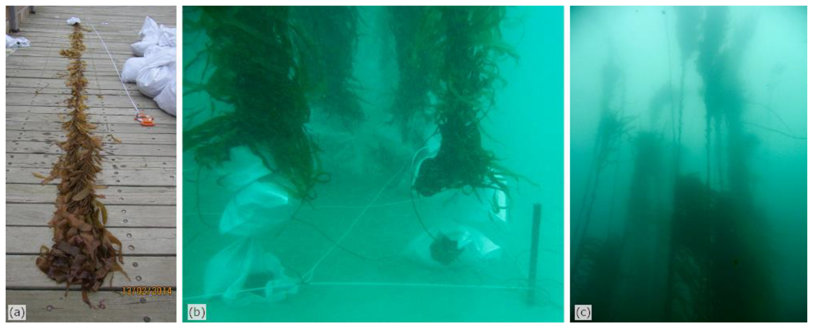
Figure 1. The experimental setting: (a) individual plant being measured at the port after harvesting; (b) setting of the bagged holdfasts in the quadrat; and (c) "dense" forest patch in situ.
Remotesensing 12 01371 g001
Figure 2. (a) Illustration of the data acquisition procedure, consisting of running the vessel on predefined tracks (arrows) on either side of the patch (4 × 4 m quadrat), keeping it always on portside. The blue circle represents the base of the “target volume”. (b) Location of each plant in the 4 × 4 m quadrat for the dense forest patch. Numbers in each cell correspond to the bag tag labels indicated in Table 1. (c) Idem for the thin forest patch. (d) 3D illustration of how the volume of water-column actually insonified in any given raw data file (in blue) misses the top part of the target volume (full cylinder) due to the limited angular aperture of the swath.
Remotesensing 12 01371 g002
Figure 3. Illustration of EM 2040 C MBES water-column data acquired in an area with no water-column targets: (a) before and (b) after application of the slant-range signal normalization (SRSN) filter. Data shown are for the first ping of the first file (300 kHz, 25 μs “very short” CW), displayed in the swath plane with the sonar head as axes origin. The coloured arrows point at: (black) the seafloor echo, (red) the specular artefact, (blue) the unidentified artefact, and (green) outer-beams high noise level. The detected bottom is also shown overlaying the seafloor echo as black dots.
Remotesensing 12 01371 g003
Figure 4. Illustration of EM 2040 C MBES water-column data acquired over naturally occurring giant kelp on a rocky reef: (a) before and (b) after application of the SRSN filter. The black arrows point at the near-vertical, high-intensity echoes extending from the seafloor through the water column, produced by giant kelp plants.
Remotesensing 12 01371 g004
Figure 5. Illustration of EM 2040 C MBES water-column data acquired at 200 kHz over the dense forest patch before and after application of the SRSN filter, for different pulse length settings: (a) 25 μs pulse data example before filtering and (b) same ping after filtering, (c) 50 μs pulse data example before filtering and (d) same ping after filtering, (e) 100 μs pulse data example before filtering and (f) same ping after filtering. Data shown are for the ping corresponding to the shortest horizontal distance to the patch, in the first file acquired for each setting.
Remotesensing 12 01371 g005
Figure 6. Illustration of EM 2040 C MBES water-column data acquired at 300 kHz over the dense forest patch before and after application of the SRSN filter, for different pulse length settings: (a) 25 μs pulse data example before filtering and (b) same ping after filtering, (c) 50 μs pulse data example before filtering and (d) same ping after filtering, (e) 100 μs pulse data example before filtering and (f) same ping after filtering. Data shown are for the ping corresponding to the shortest horizontal distance to the patch, in the first file acquired for each setting.
Remotesensing 12 01371 g006
Figure 7. Illustration of EM 2040 C MBES water-column data acquired at 400 kHz over the dense forest patch before and after application of the SRSN filter, for different pulse length settings: (a) 25 μs pulse data example before filtering and (b) same ping after filtering, (c) 50 μs pulse data example before filtering and (d) same ping after filtering, (e) 100 μs pulse data example before filtering and (f) same ping after filtering. Data shown are for the ping corresponding to the shortest horizontal distance to the patch, in the first file acquired for each setting.
Remotesensing 12 01371 g007
Figure 8. Horizontal slice-through at 1.5 m above the seafloor for a file acquired at 200 kHz over the dense or thin forest patch, using different pulse length settings: (a) 25 μs pulse data on dense forest, (b) 25 μs pulse data on thin forest, (c) 50 μs pulse data on dense forest, (d) 50 μs pulse data on thin forest, (e) 100 μs pulse data on dense forest, (f) 100 μs pulse data on thin forest. The cross is the centre of the patch. The 3 m radius circle is the base of the target volume.
Remotesensing 12 01371 g008
Figure 9. Horizontal slice-through at 1.5 m above the seafloor for a file acquired at 300 kHz over the dense or thin forest patch, using different pulse length settings: (a) 25 μs pulse data on dense forest, (b) 25 μs pulse data on thin forest, (c) 50 μs pulse data on dense forest, (d) 50 μs pulse data on thin forest, (e) 100 μs pulse data on dense forest, (f) 100 μs pulse data on thin forest. The cross is the centre of the patch. The 3 m radius circle is the base of the target volume.
Remotesensing 12 01371 g009
Figure 10. Horizontal slice-through at 1.5 m above the seafloor for a file acquired at 400 kHz over the dense or thin forest patch, using different pulse length settings: (a) 25 μs pulse data on dense forest, (b) 25 μs pulse data on thin forest, (c) 50 μs pulse data on dense forest, (d) 50 μs pulse data on thin forest, (e) 100 μs pulse data on dense forest, (f) 100 μs pulse data on thin forest. The cross is the centre of the patch. The 3 m radius circle is the base of the target volume.
Remotesensing 12 01371 g010
Figure 11. Average of the filtered backscatter level recorded within the target volume as a function of the shortest horizontal distance to the patch. Each of the nine plots displays the data for one combination of the sonar settings: (top left) 400 kHz and 25 μs pulse, (top) 400 kHz and 50 μs pulse, (top right) 400 kHz and 100 μs pulse, (left) 300 kHz and 25 μs pulse, (middle) 300 kHz and 50 μs pulse, (right) 300 kHz and 100 μs pulse, (bottom left) 200 kHz and 25 μs pulse, (bottom) 200 kHz and 50 μs pulse, (bottom right) 200 kHz and 100 μs pulse. Colours and symbols differ for the dense forest patch (blue stars) and thin forest patch (red circles).
Remotesensing 12 01371 g011
Figure 12. Average of the filtered backscatter level recorded within the target volume as a function of the ratio of the targeted volume that was insonified. Each of the nine plots displays the data for one combination of the sonar settings: (top left) 400 kHz and 25 μs pulse, (top) 400 kHz and 50 μs pulse, (top right) 400 kHz and 100 μs pulse, (left) 300 kHz and 25 μs pulse, (middle) 300 kHz and 50 μs pulse, (right) 300 kHz and 100 μs pulse, (bottom left) 200 kHz and 25 μs pulse, (bottom) 200 kHz and 50 μs pulse, (bottom right) 200 kHz and 100 μs pulse. Colours and symbols differ for the dense forest patch (blue stars) and thin forest patch (red circles).
Remotesensing 12 01371 g012
Figure 13. Average of the filtered backscatter level recorded within the target volume, displayed as box plots for each patch setup and each combination of sonar settings: (top left) 400 kHz and 25 μs pulse, (top) 400 kHz and 50 μs pulse, (top right) 400 kHz and 100 μs pulse, (left) 300 kHz and 25 μs pulse, (middle) 300 kHz and 50 μs pulse, (right) 300 kHz and 100 μs pulse, (bottom left) 200 kHz and 25 μs pulse, (bottom) 200 kHz and 50 μs pulse, (bottom right) 200 kHz and 100 μs pulse. On each plot, the red line represents the median value, the box represents the quartile estimates, and the error bars show the full data range (minimum and maximum). The symbol in the centre of each panel represents the result of a Welch’s unequal variances t-test of the hypothesis of equal mean between each patch setup (* p < 0.05, ** p < 0.01, *** p < 0.001, **** p < 0.0001).
Remotesensing 12 01371 g013
Table 1. Tag number, length, and wet weight of each plant harvested, and their use in the two experiments.
Tag NumberLength (m)Weight (kg)Dense Forest exp.Thin Forest exp.
339.821.6XX
457.620.9X
469.617.1X
471122.6XX
488.210.4X
4911.313.8X
549.417.7X
5510.49.2XX
569.414.5XX
587.5510XX
6110.419XX
629.111.3X
6310.98.9XX
649.612.3X