Technical Note

UAV + BIM: Incorporation of Photogrammetric Techniques in Architectural Projects with Building Information Modeling Versus Classical Work Processes

by
Carlos Rizo-Maestre
1,*,
Ángel González-Avilés
1,
Antonio Galiano-Garrigós
1,
María Dolores Andújar-Montoya
2 and
Juan Antonio Puchol-García
3
1
Department of Architectural Constructions, University of Alicante, 03690 San Vicente del Raspeig, Alicante, Spain
2
Building Sciences and Urbanism Department, University of Alicante, 03690 San Vicente del Raspeig, Alicante, Spain
3
Department of Computer Science and Artificial Intelligence, University of Alicante, 03690 San Vicente del Raspeig, Alicante, Spain
*
Author to whom correspondence should be addressed.
Remote Sens. 2020, 12(14), 2329; https://doi.org/10.3390/rs12142329
Submission received: 29 May 2020 / Revised: 15 July 2020 / Accepted: 16 July 2020 / Published: 20 July 2020
(This article belongs to the Special Issue UAV Photogrammetry and Remote Sensing)

Abstract

:
The current computer technology facilitates the processing of large volumes of information in architectural design teams, in parallel with recent advances in-flight automation in unmanned aerial vehicles (UAVs) along with lower costs, facilitates their use to capture aerial photographs and obtain orthophotographs and 3D models of relief and terrain textures. With these technologies, 3D models can be produced that allow different geometric configurations of the distribution of construction elements on the ground to be analyzed. This article presents the process of implementation in a terrain integrated into the early stages of architectural design. A methodology is proposed that covers the detailed capture of terrain, the relationship with the architectural design environment, and its implementation on the plot. As a novelty, an inverse perspective to the remaining disciplines is presented, from the inside of the object to the outside. The proposed methodology for the use of UAVs integrates terrain capture, generation of the 3D mesh, superimposition of environmental realities and architectural design using building information modeling (BIM) technologies. In addition, it represents the beginning of a line of research on the implementation of the plot and the layout of foundations using UAVs. The results obtained in the study carried out in three different projects comparing traditional technologies with the integration of UAVs + BIM show a clear improvement in the second option. The use of new technologies applied to the execution and control of work not only improves accuracy but also reduces errors and saves time, which undoubtedly indicates significant savings in costs and deviations in the project.

Graphical Abstract

1. Introduction

The use of unmanned aerial vehicles (UAVs) for photogrammetry has been driven by three aspects: the improvement of their performance both in-flight stability and in increasing the quality of photographic capture, and the developments in the field of graphic computing with structure from motion algorithms (SfM) Eisenbeiss and Sauerbier [1], García-Pulido et al. [2] Irschara et al. [3]. Today’s UAVs, costing less than $1000, can fly over planned routes and carry out photo capture plans at predefined heights with photo resolution above 20 megapixels Colomina et al. [4] Rodriguez-Navarro et al. [5] García-Pulido et al. [2]. With the improvement of image resolution, it is still important to improve the accuracy of point correspondence calculations between different photographs Agüera-Vega et al. [6], Dai and Lu [7] in addition to improving computational processes Fraser and Edmundson [8]. The current status of UAVs and their photogrammetry allows 2D and 3D models to be obtained from photographs taken with certain restrictions Everaerts [9] and are based on classic stereo viewing techniques Hiep et al. [10]. The field of photogrammetry UAV application has evolved in all disciplines. This article presents a design methodology based on two starting points: obtaining 2D and 3D terrain models with acceptable quality and precision in construction and the availability of integrated systems in the design and execution phases of buildings to be integrated into BIM (building information modeling) tools. There are three different situations: the possibility of using it as an instrument of measurement and representation (data collection), a tool for the architectural design phase (decision making) and finally, as a tool for reconsideration (implementation).

1.1. From Outside-to-Inside

The work with UAVs in buildings is mainly from an outside view to the inside (of the buildings), that is, as an element of remote observation, from a mapping point of view to obtain a catalog of what exists. This technology is increasingly being used to support inspection tasks in industrial and civil applications. Usually, the end user completes the procedure once the flight mission is over, and the video transmission and joint data collected by the UAV are examined. At this point, it can be integrated with the BIM methodology.
Applied in disciplines closer to architecture such as archeology, digital cataloging improves conservation, archeological research and local tourism, as demonstrated by the Delphi4Delphi International Project on Cyberarchaeology in Greece. Archeology has an advantage over architecture in the application of UAVs in the initial cataloging phase, and the first moral and technical debates arise from the fact that it involves a very high cost of labor and concerns arise as to whether a midrange scanner can capture enough details about rock art Opitz et al. [11]. The use of UAVs is rapidly advancing in almost all disciplines where there are objects to be observed, cataloged or recorded. The creative use of this instrument shows that there is a wide field of application in all of these disciplines, which leads us to investigate their inclusion in the field of architecture and propose new uses.
The origin of unmanned aerial vehicles (UAVs), commonly known as “drones”, can be placed chronologically at the beginning of the 20th century with mainly military purposes Dalamagkidis et al. [12], and many civilian uses have emerged in this decade. The use of UAVs has been extended to search and rescue missions Kim et al. [13], surveillance, transport systems Sánchez-Bou and López-Pujol [14], high-resolution map production, fire detection Wing et al. [15], crop monitoring or fumigation Faiçal et al. [16], forest inventory studies, and the propagation of trees by studying conifer tree cover Ivosevic et al. [17]. UAVs have also been applied in geothermal energy Harvey et al. [18], biodiversity and biology Bohmann et al. [19]. One of the most frequent uses of UAVs is their application to the calculation of volumes. These techniques are complemented by others such as the evaluation of the accuracy of ice measurement with terrestrial laser scanner Gasinec et al. [20].
Applied to earthworks in civil works, it can reach accuracies of up to 2.5 cm per pixel, which allows us to record the furrows of tractor wheels Vergouw et al. [21]. Another field of application for UAVs is the study of wildlife conservation by remote control; their use allows information to be collected from places that are difficult to access, minimizing disturbance and allowing biodiversity to be predicted Ivošević et al. [22]. In the field of application of automatic object detection, its use allows a step to be taken between manual operation and the complete automation of traditional inspection procedures Vaquero-Melchor et al. [23].

1.2. From Fieldwork to Virtual Design: BIM as a Tool towards Sustainability

In disciplines such as architecture and within the set of activities that we refer to as outside-to-inside, the most frequent area of application is an intervention in heritage. Europe is at the forefront of digital cultural heritage. In addition to topography, soil measurements, inspections, photography, construction site monitoring or surveillance, 3D optical documentation of both buildings and urban elements (old or modern) is also available Arias et al. [24]. Applications include the control of historic buildings Püschel et al. [25] and the detection of defects in structures or building facades Aydin [26] Remondino et al. [27]. For its application in construction, activities with UAVs such as weaving Mirjan et al. [28], painting surfaces Vempati [29], collecting and laying bricks Augugliaro [30] or spraying mortar Chaltiel et al. [31] have been underway for years.
The search for efficiency within the construction industry has led to savings in all areas to minimize production costs. The new tools for generating virtual scenarios, provided by the UAVs among other systems (Figure 1), facilitate the study of the constructive possibilities of a terrain; that is, the possible studies of landscape integration, orientation and composition of future buildings. Based on the mesh generated on the plot, together with the necessary tools, the final building results can be approached with a computer model Garrigós and Kouider [32].
Poor management of information in previous phases of the construction process (design, orientation, distribution, etc.) turns buildings into energy loss systems Gaujena et al. [33]. There are researchers devoted exclusively to interpreting the relationship between the shape of a building and its energy consumption demand for both temperate and cold climates Domínguez et al. [34]. The projection forms generated by the new software allow for more accurate representations that help generate more efficient buildings in all fields and stages Cho et al. [35]. The common objective of this process is to achieve the highest efficiency buildings Pellegrino et al. [36] Larsen et al. [37]. Researchers worldwide are developing strategies to address and integrate these techniques into construction processes Wang et al. [38]. There are even BIM tools that allow us to detect whether the modeling of a building is accurate according to the construction conditions Lou et al. [39].
The demand for sustainable buildings with a low environmental impact is increasing. Building information modeling (BIM) gives the building construction process greater control over the energy performance of buildings from the earliest stages. Studies have measured the performance of different programs, such as Virtual Environment TM , Ecotect TM or Green Building Studio TM Azhar and Brown [40]. Construction management programs also extend to the modeling of the complete life cycle of buildings (LCAs) Bruce-Hyrkäs et al. [41]. IT developments help to ensure that efficient construction measures are provided even in the early stages of projects Jalaei and Jrade [42]. Buildings are becoming more sustainable due to these processes and generate a lower environmental impact Turner et al. [43]. Building designs managed from BIM software can help sustainability directly or indirectly, saving in construction processes, optimizing orientations, spaces, piping or even providing information on energy costs according to different project strategies Krygiel and Nies [44]. The construction design should start by analyzing the evaluation of the thermal load loss of the building according to its location Peruzzi et al. [45] Pérez-Lombard et al. [46]. In Italy, this process is defined by the UNE EN ISO 13790 standard.
Research in these fields is also applied to buildings Vollaro et al. [47]. There are branches of research that apply techniques for recognizing the properties of buildings that have already been built Ham and Golparvar-Fard [48]. Evaluation tools increasingly condition interventions in existing buildings Motawa and Carter [49]. Simulations of the energy demand of a building allow the interpretation of thermal needs according to the location conditions Kim et al. [50], and even according to the materials used and their life cycle from their construction to their use stage Martínez-Rocamora et al. [51]. There are studies that combine these work processes with case studies and compare the different typologies and constructions Scheuer et al. [52] Raji et al. [53]. These processes also help to find the optimal conditions for passive buildings with almost no energy consumption Mahdavi and Doppelbauer [54] or tall buildings Raji et al. [53].
The carbon footprint is the maximum element of control of whether a generated process is sustainable. Buildings can be measured to confirm the carbon footprint they generate during their lifetime Qin et al. [55], even during their end-of-life stage for subsequent recycling Thormark [56]. Regulations are becoming increasingly stringent in the field of construction, even if the measurement systems for these processes are not yet optimally developed Bribián et al. [57] Tronchin and Fabbri [58]. Therefore, technology is being applied to develop more efficient buildings and to monitor those already implemented Serrano and Álvarez [59] Evangelisti et al. [60]. In addition, work is underway to introduce these advances into the regulatory and control processes for building energy systems Evangelisti [61]. These jobs can lead to savings that could be of social interest Macias et al. [62].

2. Objectives

2.1. Bringing the Outside-to-Inside Methodology Closer to the User

All the examples of UAV applications we have discussed are from an outside-to-inside view. Our proposal for application to the architectural discipline is proposed in two phases: the topography phase and the stakeout phase:
  • Topography: Its application not only consists of the collection and cataloging of data but also if the novelty of the inside to outside perspective is added in this chronological stage of the design implementation process, it can serve as a real scenario of the architecture and be used as a projection tool.
  • Stakeout: Through the application of UAVs, the novelty of serving as a tool for staking out foundations and arming is proposed.

2.2. UAV Environment Acquisition. Photogrammetric 3D Reconstruction

The management of information prior to the development of a building has different stages, from the fieldwork where the environmental information is accumulated (the work with UAVs creates great advantages) to the creation of the final images of the future project. Figure 2 shows the four stages of work for the creation of virtual images in architecture: photogrammetry, 3D design, rendering and postproduction.
The technology of capturing environments with UAVs applied to this design phase makes it possible to realize the way in which an architectural space is inhabited and the relationship with the place from within the architecture; something that is difficult to achieve with other tools such as models. A model allows the previous study from outside-to-inside to be a very powerful instrument of architectural analysis Carrión et al. [63].
The use of the UAV in buildings is used to obtain all the fundamental aspects of a place, location or urban environment by using the UAVs for the 3D reconstruction associated with its cadastral reference as a tool to project any object.
The technology used by UAVs to reconstruct 3D surfaces from photographs is a mathematical problem that has been explained by Koch Koch [64]; it uses the correspondence of different images taken from different positions, which combined with interpolation and triangulation allows the height map needed to create a 3D mesh of the terrain to be reconstructed.
In the case presented in this study, a UAV was used to systematically scan the terrain following a predetermined path, in which one of the starting conditions of this route is the high overlap between the programmed images. Thus, the system uses multiple photographs of the terrain, which are paired to form a stereo pair. In other words, by capturing the same area from different positions, it is possible to make out the correspondence of points between them which, together with the necessary trigonometric information, produces a model with the 3D surface reconstructed in a way faithful to reality.
The programmed flight carried out by the UAV has a trajectory and height of flight fixed in each instant that allows us to interpret the data of coating or overlap between the different images where each one of the photographs was taken with respect to the contiguous photograph. The stages of this process are as follows:
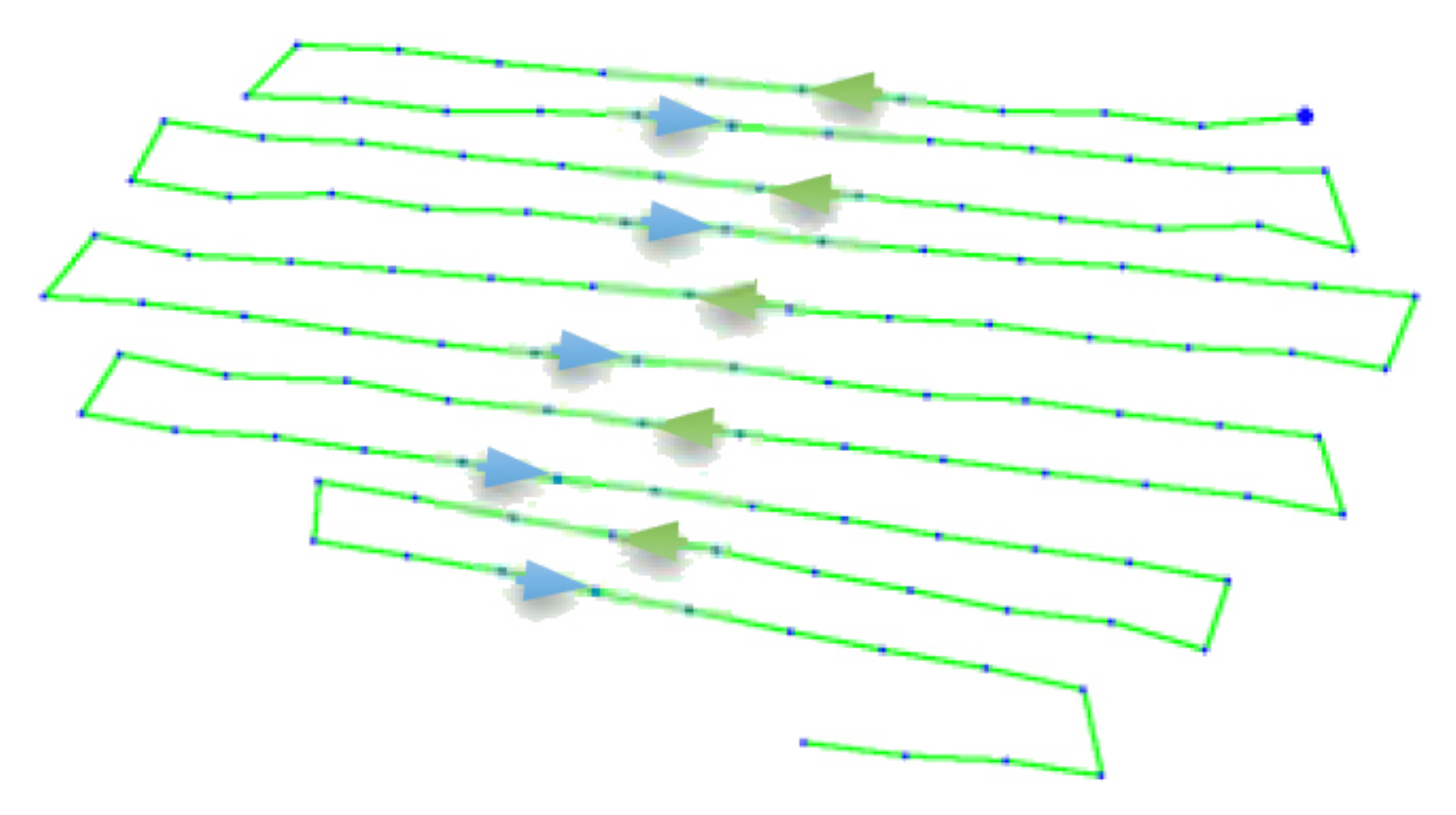
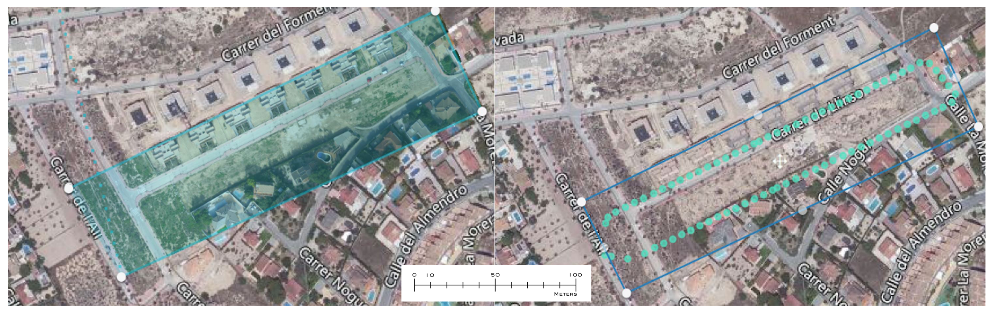
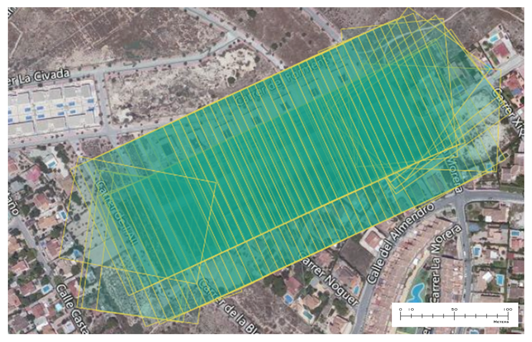
  • Programming the route with the premises
  • Obtaining images
  • Image adjustment and correlation.
  • Correspondence of the same point in several images.
  • Dimensioning by means of epipolar geometry.

3. Method

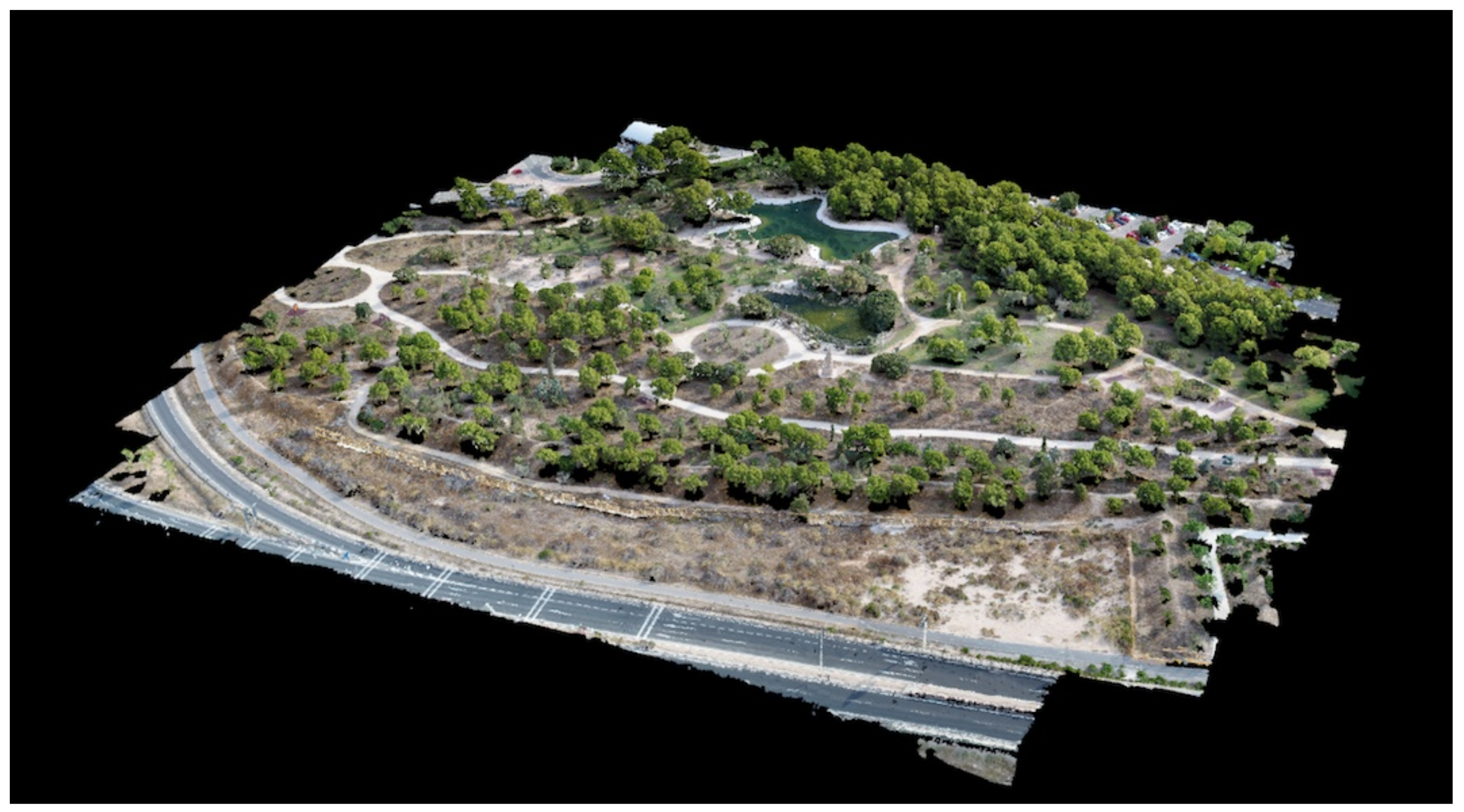
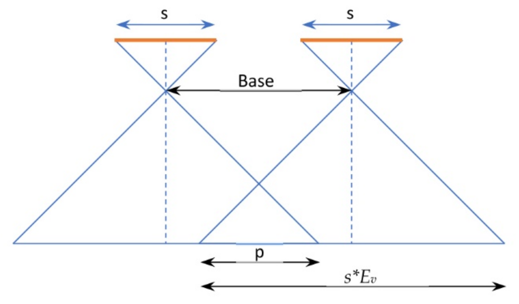
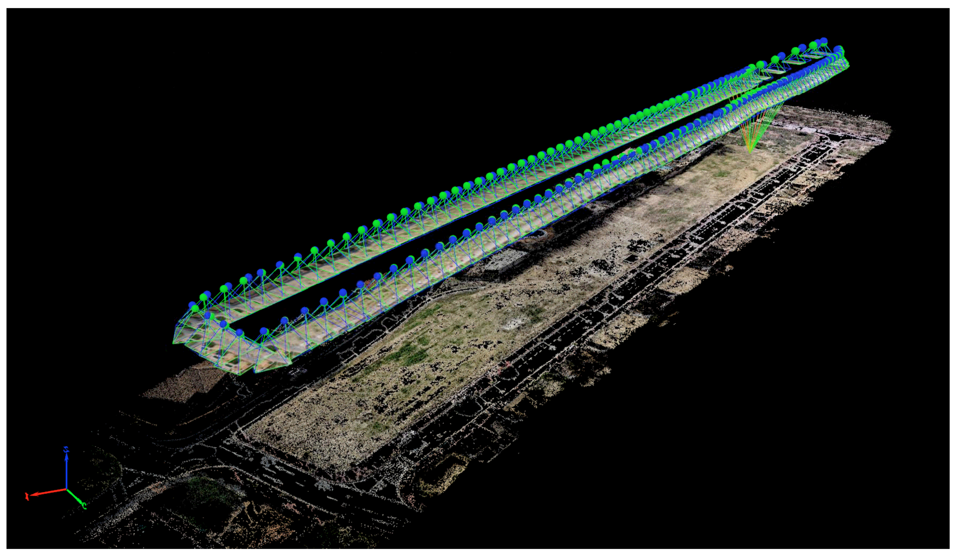
3.1. Photogrammetry with UAV

The interpretation of the data obtained by the UAV is a process based on a trigonometric problem. In a photograph, there is a main point where the perpendicular axis of the photograph intersects the plane of the ground. The main distance is a feature of the camera that corresponds to the distance between the lens and the negative plane of the photograph.
In addition to the data that must be recognized in the photograph, the scale at which the work is performed is also important, since it is directly proportional to the height at which the photograph was taken. Obtaining the 3D reconstruction of the terrain is considered in two situations represented in Figure 3 Otero et al. [65].
When the topography is practically horizontal, it is considered to be flat terrain, as it is easy to obtain the working scale with the following equation directly proportional to the focal length of the camera and inversely proportional to the height of flight:
a b A B = f H = 1 E = S c a l e o f t h e p h o t o g r a p h ,
where E is the scale module.
Unlike flat topography, when the working height at the different points is uneven, it is considered a variable terrain. Therefore, to calculate the working scale, the height must be recalculated at each of the points since the terrain approaches and moves away from the camera lens according to the main working point. With an image taken at a height h, you have the following relationship:
1 E = f H h m h m = h 1 + h 2 2
In the departure orders that are established before the flight, some indispensable parameters are set: the flight height and the route and the image overlap (Figure 4). The flight altitude is obtained by GPS from the takeoff point, which is considered to be the starting point, at altitude 0. The flight path marks the different areas through which the UAV will pass and the moment when it will take an image, making an overlap or coating between one and the other. The distance between the main points of consecutive pictures allows us to fix a longitudinal coating between consecutive pictures and a lateral overlap between adjacent pictures, usually taken in opposite directions.
If we consider that the starting parameters are the following: frame side (s), frame scale (E) and longitudinal overlap (p), the air base, which is the distance in the air between two consecutive photographs (Figure 5), is calculated according to the following relation:
s * 1 p % E v .
Thus, the distance of the photographs taken on the route can also be defined with the following expression:
s * 1 q % E v ,
where q is the transverse coating.

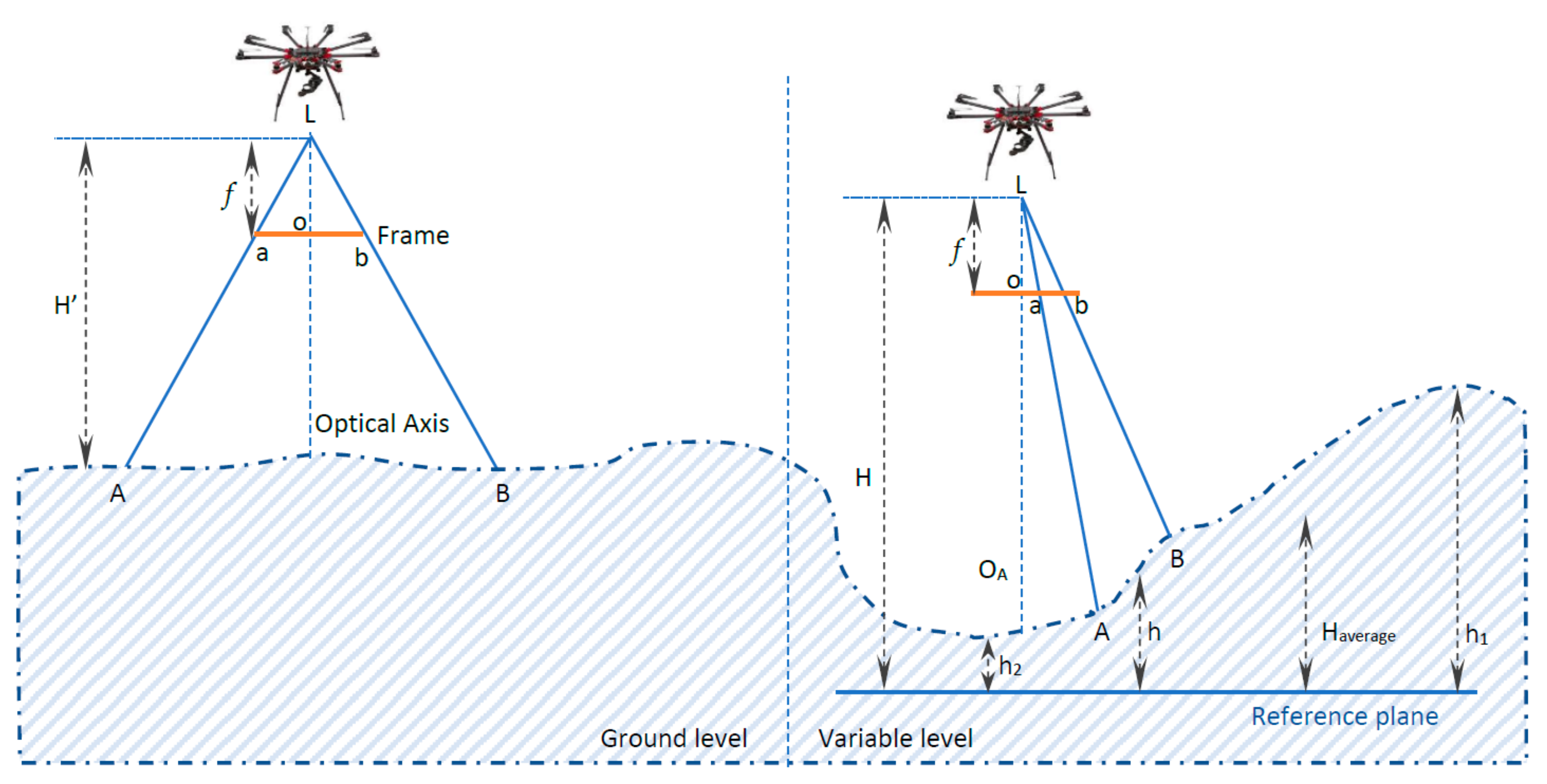
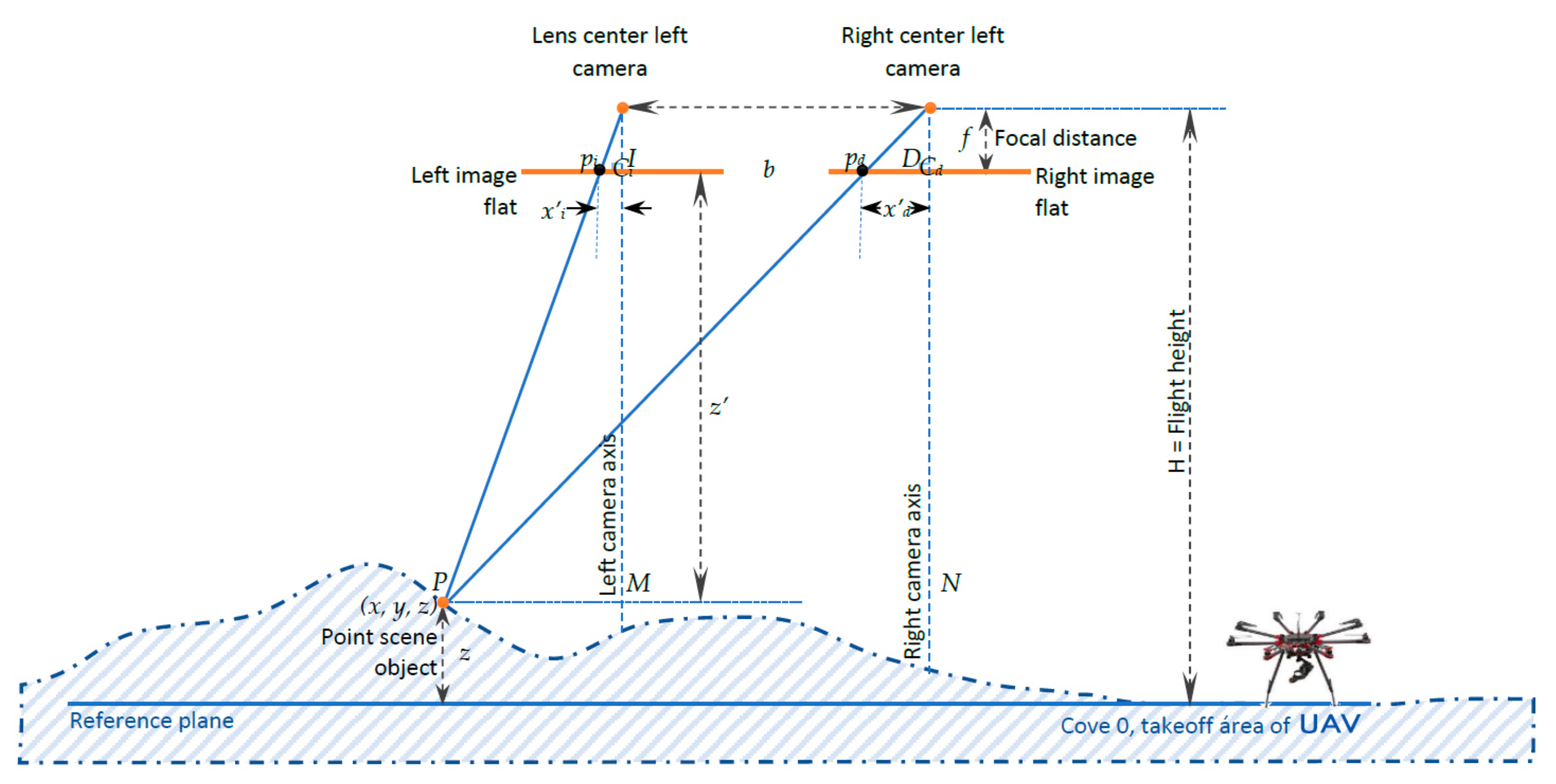
3.2. Stereoscopic Correspondence

The main problem encountered in terrain reconnaissance using UAVs is identifying specific points in different images. This has to do with the overlap of the images; the more overlap, the easier it is to find points of correspondence in different images. The way to solve this situation is the same way that it is used by human beings. We measure distances from the images captured by both eyes that come together in the brain. Applying this concept to the field of photogrammetry means solving a problem of homologous ray geometry. This process consists of four stages Vergouw et al. [21], Sánchez and Sobrino [66]:
  • Internal orientation. Determination of the perspective beam from the data known as the focal length and other parameters mentioned.
  • Relative guidance. Determination of the position of one beam in relation to the other.
  • Absolute orientation. Location and scaling according to a system of terrain coordinates
  • Restitution. Identification and correspondence of homologous rays and therefore of the height of the points on the ground.
In a predetermined flight, the height is calculated by the GPS data, considering the takeoff height, which is considered a height of 0 m. The identification of the homologous points is made by means of epipolar geometry that is based on a stereo pair of images; that is, once the correspondence of the points has been identified, the intersection of the projected lines is made to calculate the 3D coordinate (Figure 6).
The distance z from point P to the UAV camera is determined by the following trigonometric equations, where b is the air base and f is the focal length of the camera:
z = b f ( x i x d )
x z = x i f x b z = x d f
z = H z .

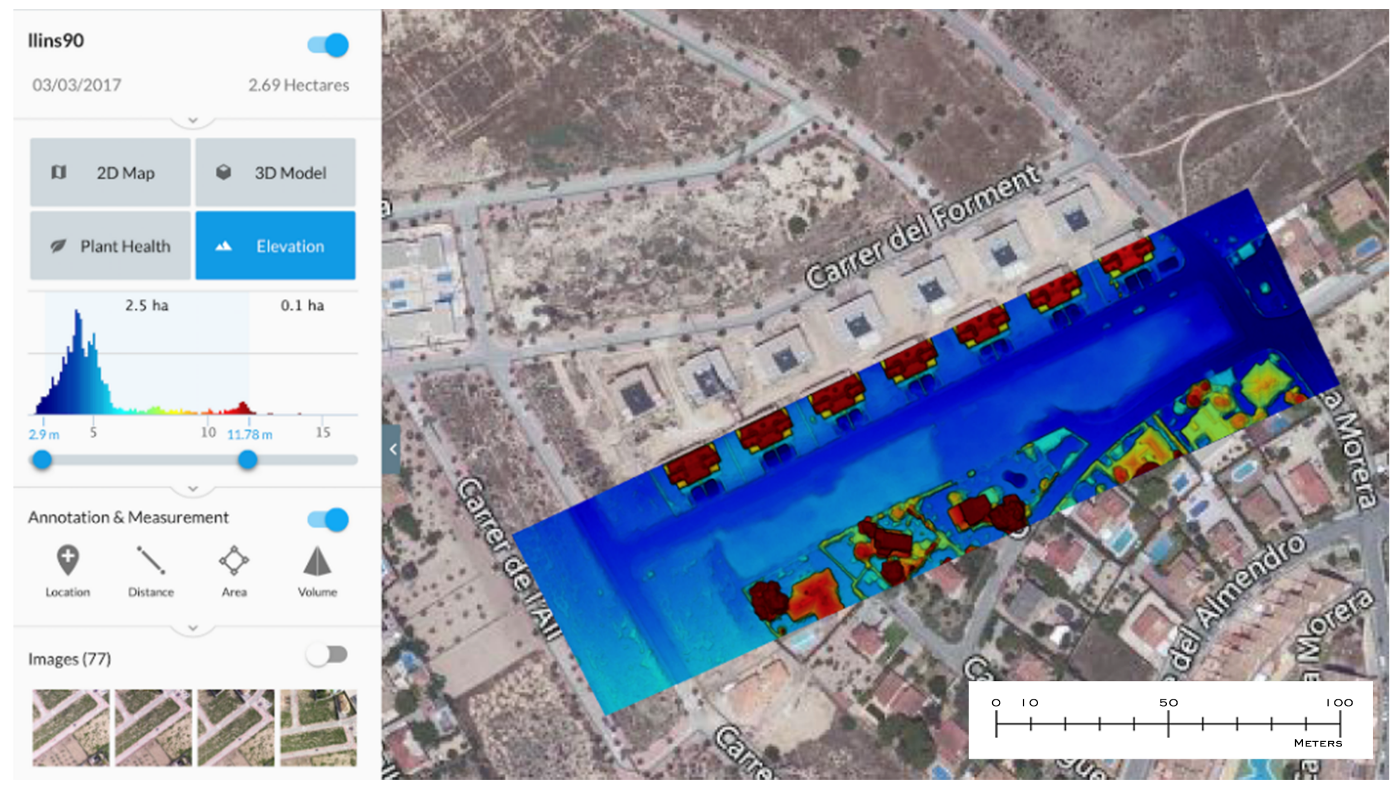
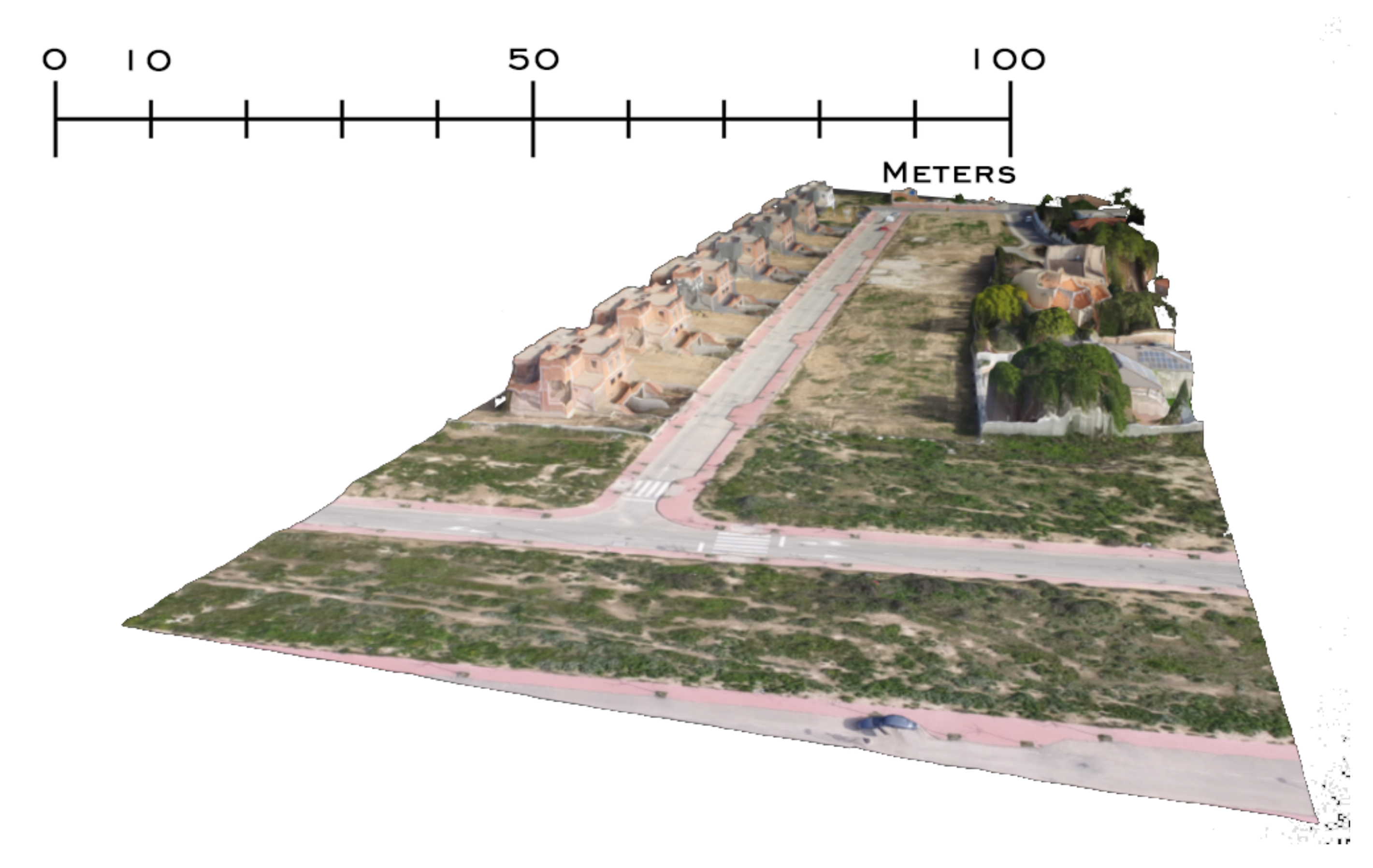
3.3. Description of the Photogrammetric Techniques Used

The UAV used in this article is the DJI Phantom 3 Advanced quadcopter, which has a GPS-based navigation system and a barometric system for altitude control. The UAV imaging system consists of a 12-megapixel camera with an f/2.8 lens and a 94-degree FOV mounted on a three-axis gimbal.
The photogrammetric techniques used are aimed at obtaining the 2D model (orthophotography of the terrain) and the 3D model (terrain relief). Two software systems were used for the tests: Dronedeploy and Pix4d. Both are goal-oriented, although each brings positive aspects (Figure 7).
We start by defining the area to be captured, first establishing the height above ground level at the UAV launch point; in the example used as a guide to the method, this was performed with a flight height of 90 m. At higher altitudes, fewer photographs will be needed, in exchange for losing resolution. Next, the outer perimeter of the capture is defined, and the overlap values of the photographs are set (lateral overlap is set at 65% and frontal overlap is set at 85%). In addition to the flight height, these two values influence both the quality and the number of photographs that will finally be taken (Figure 8).
Figure 9 shows the overlaps between photographs in a contour where the measurement is to be made of 2.69 hectares of surface. The image shows the points from which the 77 photographs required for this example are taken with the preset parameters. The UAV camera is oriented vertically to the ground.
From the 77 photographs, the orthophotography of the terrain is obtained, which is superimposed on the Google Maps satellite image in Figure 10. The orthophoto allows different operations to be carried out that serve to study the area and determine the different options for creating and locating buildings: measuring with precision, determining the elements present in the terrain, carrying out different simulations of plot occupation, sunshine, shadows cast, etc.
The triangulation of each point allows the terrain elevation map to be obtained, as shown in Figure 11, in which a gradient between blue (level 0) and red can be seen. The points of zero height are represented in dark blue and the height of 12 meters, maximum present in the region, of the adjacent buildings in red.
This technology allows the option of representing the terrain in 3D, that is, with the high-resolution orthophoto obtained and the difference in height of each point, a solid representation is generated. This solid representation is represented by a relief and texture, as shown in Figure 12, and serves as a starting point for working on the geometry of the building, its location within the plot and its relationship with the environment.

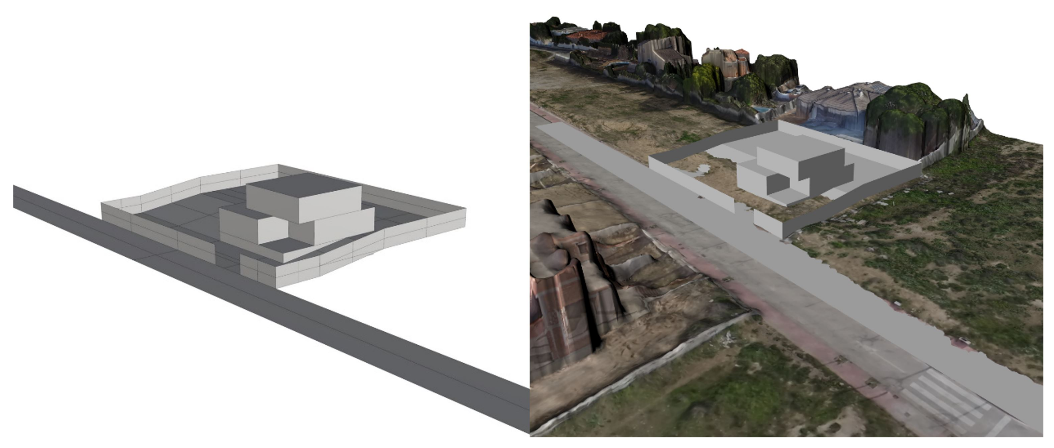
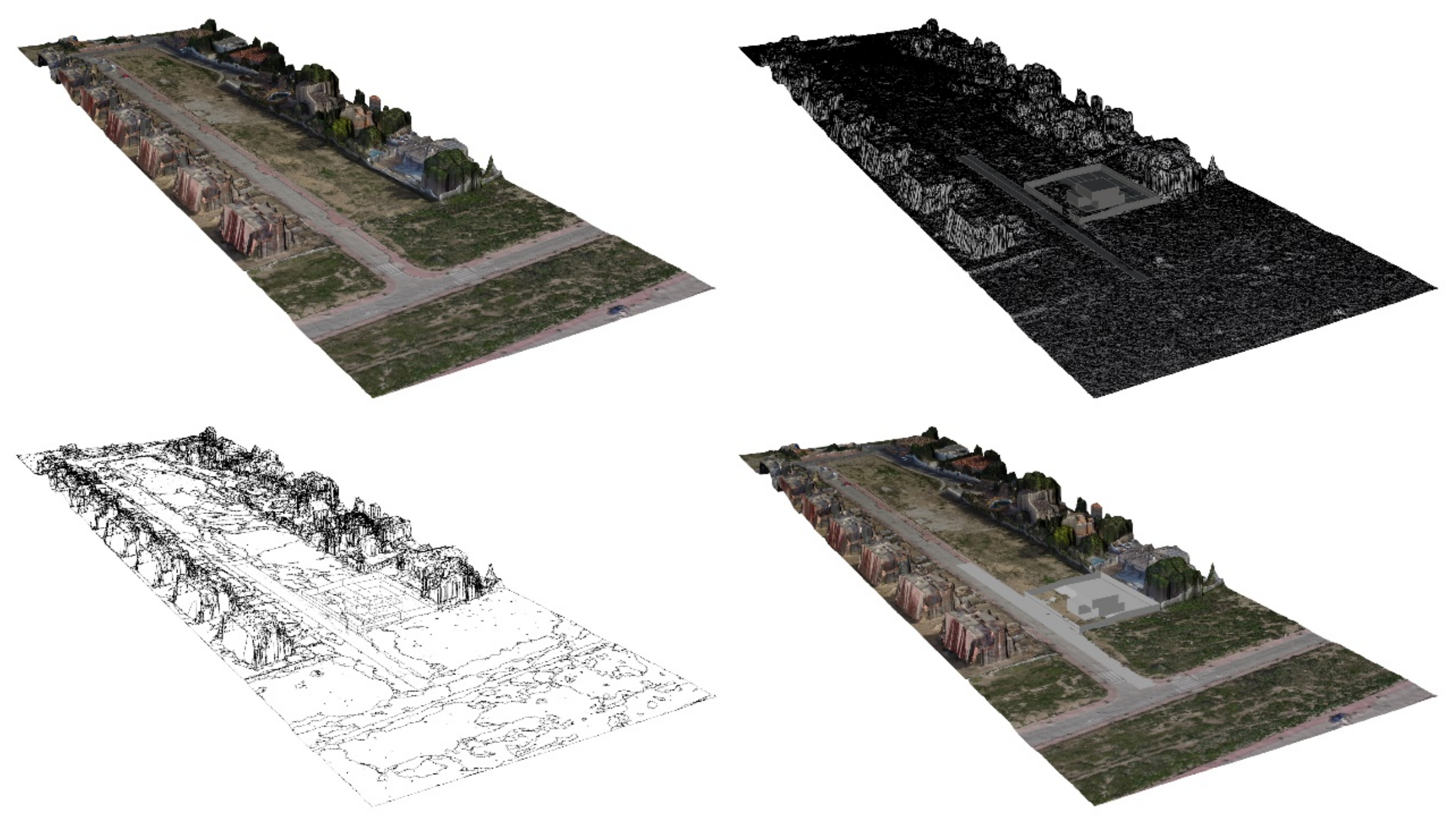
3.4. The BIM Software Interconnection. Connection of BIM Modules

The construction process from the beginning of the idea to the execution of the project is linked to the method of the architect in charge of the work. Computer software advances have made it possible to move from making all calculations and drawings by hand to being able to make them with a computer. The first software tools to help in this process were simple 2D line drawing tools and calculation systems for both structures and costs (time and economy). These programs have been developed over time to the second-generation tools, the BIM software.
BIM software programs, or building information modeling, are computer tools designed to digitally model and manage the integral information of a building for all phases of its life cycle in the form of a database Gu and London [67]. For this, 2D lines are not drawn as in CAD or computer-aided design programs, as the management of 3D files is direct; that is, working from one of the views or construction phases implies an update in the derivatives.
In BIM programs, all building information is managed Succar et al. [68], not only its design plans but also the definition of facilities and structure, which imply other indirect variations such as costs. In a large majority of the interventions analyzed, the same common denominator is found; there is no complete level of interoperability between data collection programs and BIM software Achille et al. [69]. However, the research developed allows such interoperability, which is a great advantage. From the point of view of the relationship with the environment, the method in which work is performed on an urban scale and on the scale of the architectural object is also fundamental. Some experts argue that the goal is to integrate GIS and BIM Scianna et al. [70]. The use of XML-based formats would allow the standardization of information and consult metadata of both scales on the same platform.

3.5. Integration of the Projected Building with Building Information Modeling (BIM)

The tools for generating topographies described by means of UAVs have made it possible to obtain detailed information about a certain area where the building is planned to be constructed. These data are treated with both 2D and 3D software tools, that is, they work on both the X–Y and Z planes. This is also reflected in the type of program used by BIM for the interconnection of all parts of the construction. In the introduction, we mentioned the advantage that archaeology has over UAV architecture for the data collection phase, which also applies to BIM integration.
Today, the accuracy of 3D photo surveying allows information to be quickly recorded and loaded into BIM systems. That the technological advances in data collection and its incorporation into BIM mark a before and after in the conception and design of a building is currently an objective reality. However, it is necessary to go deeper into the relationship with the environment in which the building is located with the application of these technologies to the execution on site.

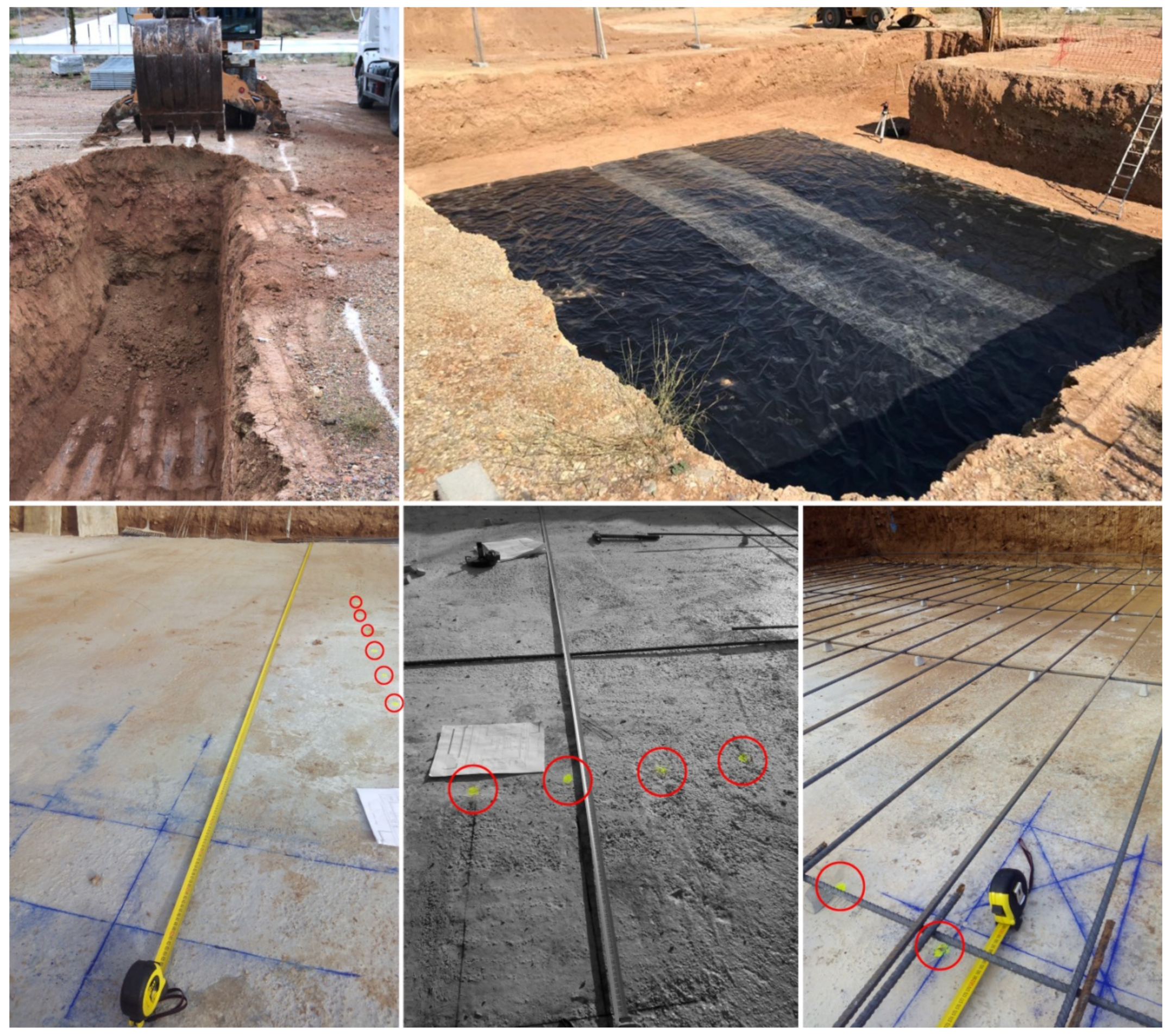
4. Evaluation of the Results Obtained in the Experience. Classic Method against UAV + BIM

At present, the process to follow after the purchase of a plot is to carry out a topographical and geotechnical study as initial tasks to carry out an execution project of a building. The main difference between the two is that the second is mandatory by law when the building to be executed must comply with the Spanish Technical Building Code (CTE) 699 [71]. However, as we mentioned, the first can be crucial for the development of the proposal and even more for the control of the execution in its initial phase of rethinking, as we will see in the following case study. Good architecture is traversed, crossed, both inside and outside Corbusier et al. [72], and we have to learn to appreciate the effective confluences of the exterior and interior Neutral et al. [73]. In this sense, it is essential to strengthen the precision of the 3D models for a better understanding of the architecture and its environment. For this reason, the paths and 360° images are parts of the projects and must integrate the architecture’s environment not as a static image but as an augmented reality.
The 2D topographic study of a plot of land is between 350 and 475 m 2 , as in the case study. The practical case we present of this work system, adapted to the region studied by the UAV, allows us to analyze from outside-to-inside the different options of volumetry and fit in the studied plot and the relation from the inside with the environment. Figure 13 shows volumetric work done in a 3D software program and the adaptation of this program to the solid representation generated by the UAV.
Figure 14 shows the process carried out for the integration of the building within the plot. This work is very useful within the first stages of study of certain buildings since it allows for different tests to see in real time a faithful approximation of the final construction.
To clarify the progress in time and cost reduction, three projects were analyzed according to the protocol followed in each of them. The three methods of approaching the implementation in the plot were the traditional method of data collection with 2D computational work, the traditional method with BIM and UAV + BIM.
Table 1 shows the synthesis of the results obtained in two situations compared to the architectural design, the design with 2D tools or with 3D software (BIM methodology). There are two methods of taking data from the plot; the traditional method with a total station and by means of DRON. In the early phase studied in the three assumptions, it was possible to quantify the time savings in the data collection phase for restatement. The accuracy factor is directly proportional to the number of points and, therefore, to the execution time of the data collection, so that in the face of the need for more time for greater precision of a technician in topography, the use of UAVs requires a maximum of 1 h for an area of 500 m 2 . The incorporation of UAVs in the early phase of implementation is proposed as a qualitative leap compared to traditional techniques. The implementation of this technique in the topography phase, the flight and its subsequent incorporation into BIM programs allows the complete database to be available for all subsequent operations (Figure 15).
Currently, the common methodology for staking out a plot is performed by means of plaster on the ground and at a later stage, tile on concrete for cleaning. The accuracy of these tools common in the construction world is far from the levels of accuracy of design tools. For this reason, UAV technology has been applied both to the creation of the topographical plan of the plot and to the laying out of the foundations, giving higher levels of precision than traditional methods. In Table 2, the precision and time data for the three scenarios studied were collected. The result is an improvement in accuracy during stakeout and assembly of 100%. In addition, although the process in scenario 3 took longer than scenarios 1 and 2 using the traditional method of restatement, it required only one person. The implementation with traditional methods required two people to correctly establish the main axes and foundation limits with respect to the boundaries of the plot, something that the use of UAVs and georeferences did not require.

5. Conclusions

The benefits of the use of UAVs in the early stages of architectural design and the connection with BIM programs have been demonstrated, making them a tremendously effective working tool. The suitability of the 3D photogrammetric survey has been proven against traditional techniques. The 3D technique allows the information to be quickly recorded and loaded into BIM systems.
The triangulation of each point of the survey allows us to obtain the complete terrain elevation map and a flight with 360° visibility that allows greater control and detail of the relationship of the architectural project with the environment in all directions.
The results obtained in the study carried out in three different projects comparing traditional technologies with UAV + BIM integration show a clear improvement in the second option. In the early phases of work, both the accuracy and the time spent show an improvement in UAV + BIM technology, as well as allowing changes in the project phase. In the phase of setting out the assembly or structure, greater precision, and less time and need for personnel, as well as more control over changes are achieved.
Finally, the use of new technologies applied to the execution and control of work not only improves accuracy but also reduces errors and saves time, which undoubtedly means a significant saving in costs and deviations in the project.

Author Contributions

The work presented here was developed in collaboration amongst all authors. All authors have contributed to, seen and approved the manuscript. All authors have read and agreed to the published version of the manuscript.

Funding

This work has been supported by the Ministerio de Ciencia, Innovación y Universidades (Spain), project RTI2018-096219-B-I00. Project cofinanced with FEDER funds.

Acknowledgments

The authors of this paper thank the University of Alicante for the grant that allowed part of this research.

Conflicts of Interest

The authors declare no conflict of interest.

References

  1. Eisenbeiss, H.; Sauerbier, M. Investigation of uav systems and flight modes for photogrammetric applications. Photogramm. Rec. 2011, 26, 400–421. [Google Scholar] [CrossRef]
  2. García-Pulido, L.J.; Jaramillo, J.R.; Dorado, M.I.A. Heritage survey and scientific analysis of the watchtowers that defended the last Islamic Kingdom in the iberian peninsula (Thirteen To Fifeteenth Century). ISPRS Int. Arch. Photogramm. Remote Sens. Spat. Inf. Sci. 2017, XLII-2/W5, 259–265. [Google Scholar]
  3. Irschara, A.; Kaufmann, V.; Klopschitz, M.; Bischof, H.; Leberl, F. Towards Fully Automatic Photogrammetric Reconstruction Using Digital Images Taken from UAVs. Int. Arch. Photogramm. Remote Sens. Spat. Inf. Sci. 2010, 38, 65–70. [Google Scholar]
  4. Colomina, I.; Blázquez, M.; Molina, P.; Parés, M.E.; Wis, M. Towards a new paradigm for high-resolution low-cost photogrammetryand remote sensing. Int. Arch. Photogramm. Remote Sens. Spat. Inf. Sci. 2008, XXXVII, 1201–1206. [Google Scholar]
  5. Rodriguez-Navarro, P.; Gil-Piqueras, T.; Verdiani, G. Drones for Architectural Surveying. Their Use in Documenting Towers of the Valencian Coast. Available online: https://www.researchgate.net/publication/320066302_Drones_for_Architectural_Surveying_Their_Use_in_Documenting_Towers_of_the_Valencian_Coast (accessed on 12 January 2020).
  6. Agüera-Vega, F.; Carvajal-Ramírez, F.; Martínez-Carricondo, P. Accuracy of Digital Surface Models and Orthophotos Derived from Unmanned Aerial Vehicle Photogrammetry. J. Surv. Eng. 2017, 143, 04016025. [Google Scholar] [CrossRef]
  7. Dai, F.; Lu, M. Assessing the Accuracy of Applying Photogrammetry to Take Geometric Measurements on Building Products. J. Constr. Eng. Manag. 2010, 136, 242–250. [Google Scholar] [CrossRef]
  8. Fraser, C.S.; Edmundson, K.L. Design and implementation of a computational processing system for off-line digital close-range photogrammetry. ISPRS J. Photogram. Remote Sens. 2000, 55, 94–104. [Google Scholar] [CrossRef]
  9. Everaerts, J. The use of unmanned aerial vehicles (UAVs) for remote sensing and mapping. Int. Arch. Photogramm. Remote Sens. Spat. Inf. Sci. 2008, 37, 1187–1192. [Google Scholar]
  10. Hiep, V.H.; Keriven, R.; Labatut, P.; Pons, J.P. Towards high-resolution large-scale multi-view stereo. In Proceedings of the 2009 IEEE Conference on Computer Vision and Pattern Recognition, Miami, FL, USA, 20–25 June 2009; pp. 1430–1437. [Google Scholar]
  11. Opitz, R.; Simon, K.; Barnes, A.; Fisher, K.; Lippiello, L. Close-Range Photogrammetry vs. 3D Scanning: Comparing Data Capture, Processing and Model Generation in the Field and the Lab. Available online: https://www.google.com.hk/url?sa=t&rct=j&q=&esrc=s&source=web&cd=&ved=2ahUKEwj685XmstjqAhUhGaYKHbY6CQAQFjABegQIAhAB&url=https%3A%2F%2Fncptt.nps.gov%2Fwp-content%2Fuploads%2Fsimon.pdf&usg=AOvVaw2sB1-arFK-LCViuMGoKuox (accessed on 12 January 2020).
  12. Dalamagkidis, K.; Valavanis, K.P.; Piegl, L.A. On Integrating Unmanned Aircraft Systems into the National Airspace System; Springer: Dordrecht, The Netherlands, 2012. [Google Scholar]
  13. Kim, K.; Hyun, J.; Myung, H. Development of aerial image transmitting sensor platform for disaster site surveillance. In Proceedings of the 2017 17th International Conference on Control, Automation and Systems, Jeju, South Korea, 18–21 October 2017; pp. 794–796. [Google Scholar]
  14. Sánchez-Bou, C.; López-Pujol, J. The coming revolution: The use of drones in plant conservation. Collect. Bot. 2014, 33, 7. [Google Scholar]
  15. Wing, M.G.; Burnett, J.D.; Sessions, J. Remote Sensing and Unmanned Aerial System Technology for Monitoring and Quantifying Forest Fire Impacts. Int. J. Remote Sens. Appl. 2014, 4, 18. [Google Scholar] [CrossRef]
  16. Faiçal, B.S.; Costa, F.G.; Pessin, G.; Ueyama, J.; Freitas, H.; Colombo, A.; Fini, P.H.; Villas, L.; Osório, F.S.; Vargas, P.A.; et al. The use of unmanned aerial vehicles and wireless sensor networks for spraying pesticides. J. Syst. Archit. 2014, 60, 393–404. [Google Scholar] [CrossRef]
  17. Ivosevic, B.; Han, Y.G.; Kwon, O. Calculating coniferous tree coverage using unmanned aerial vehicle photogrammetry. J. Ecol. Environ. 2017, 41, 10. [Google Scholar] [CrossRef] [Green Version]
  18. Harvey, M.C.; Harvey, C.C.; Rowland, J.; Luketina, K.M. Drones in geothermal exploration: Thermal infrared imagery, aerial photos and digital elevation models. In Proceedings of the 6th African Rift Geothermal Conference, Addis Ababa, Ethiopia, 2–4 November 2016. [Google Scholar]
  19. Bohmann, K.; Schnell, I.B.; Gilbert, M.T.P. When bugs reveal biodiversity. Mol. Ecol. 2013, 22, 909–911. [Google Scholar] [CrossRef] [PubMed]
  20. Gasinec, J.; Gašincová, S.; Černota, P.; Staňková, H. Uses of terrestrial laser sanning in mnitoring of ground ice within dobšinská ice cave. J. Pol. Miner. Eng. Soc. 2012, 30, 31–42. [Google Scholar]
  21. Vergouw, B.; Nagel, H.; Bondt, G.; Custers, B. Drone Technology: Types, Payloads, Applications, Frequency Spectrum Issues and Future Developments In The Future of Drone Use; TMC Asser Press: The Hague, The Netherlands, 2016. [Google Scholar]
  22. Ivošević, B.; Han, Y.G.; Cho, Y.; Kwon, O. The use of conservation drones in ecology and wildlife research. J. Ecol. Environ. 2015, 38, 113–118. [Google Scholar] [CrossRef] [Green Version]
  23. Vaquero-Melchor, D.; Campaña, I.; Bernardos, A.M.; Bergesio, L.; Besada, J.A. A distributed drone-oriented architecture for in-flight object detection. In Proceedings of the 13th International Conference on Hybrid Artificial Intelligence Systems, Oviedo, Spain, 20–22 June 2018; Springer: Cham, The Netherlands, 2018. [Google Scholar]
  24. Arias, P.; Herráez, J.; Lorenzo, H.; Ordóñez, C. Control of structural problems in cultural heritage monuments using close-range photogrammetry and computer methods. Comput. Struct. 2005, 83, 1754–1766. [Google Scholar] [CrossRef]
  25. Püschel, H.; Sauerbier, M.; Eisenbeiss, H. A 3D model of Castle Landenberg (CH) from combined photogrammetric processing of terrestrial and UAV-based images. Int. Arch. Photogramm. Remote Sens. Spat. Inf. Sci. 2008, 37, 93–98. [Google Scholar]
  26. Aydin, C.C. Designing building façades for the urban rebuilt environment with integration of digital close-range photogrammetry and geographical information systems. Autom. Constr. 2014, 43, 38–48. [Google Scholar] [CrossRef]
  27. Remondino, F.; Barazzetti, L.; Nex, F.; Scaioni, M.; Sarazzi, D. UAV photogrammetry for mapping and 3d modeling—Current status and future perspectives. ISPRS Int. Arch. Photogramm. Remote Sens. Spat. Inf. Sci. 2012, XXXVIII-1/C22, 25–31. [Google Scholar] [CrossRef] [Green Version]
  28. Mirjan, A.; Gramazio, F.; Kohler, M.; Augugliaro, F.; Andrea, R.D. Architectural fabrication of tensile structures with flying machines. In Green Design, Materials and Manufacturing Processes; Taylor & Francis Group: London, UK, 2013. [Google Scholar]
  29. Vempati, A.S. PaintCopter: An Autonomous UAV for Spray Painting on Three-Dimensional Surfaces. IEEE Robot. Autom. Lett. 2018, 3, 2862–2869. [Google Scholar] [CrossRef]
  30. Augugliaro, F. The flight assembled architecture installation: Cooperative contruction with flying machines. IEEE Control Syst. 2014, 34, 46–64. [Google Scholar]
  31. Chaltiel, S.; Bravo, M.; Chronis, A. Digital fabricationwith Virtual and Augmented Reality for Monolithic Shells. Available online: https://www.researchgate.net/publication/320839954_Digital_fabrication_with_Virtual_and_Augmented_Reality_for_Monolithic_Shells (accessed on 12 January 2020).
  32. Garrigós, A.; Kouider, T. The Virtual Interactive Relationship Between BIM Project Teams: Effective Communication to aid Collaboration in the Design Process. In Healthy Buildings, Innovation, Desing & Technology: Conference Proceedings of the 6th International Congress of Architectural Technology; Universidad de Alicante: San Vicente del Raspeig, Spain, 2016; pp. 12–14. [Google Scholar]
  33. Gaujena, B.; Borodinecs, A.; Zemitis, J.; Prozuments, A. Influence of Building Envelope Thermal Mass on Heating Design Temperature. IOP Conf. Ser. Mater. Sci. Eng. 2015, 96, 012031. [Google Scholar] [CrossRef] [Green Version]
  34. Domínguez, S.; Sendra, J.J.; León, A.L.; Esquivias, P.M. Towards Energy Demand Reduction in Social Housing Buildings: Envelope System Optimization Strategies. Energies 2012, 5, 2263–2287. [Google Scholar] [CrossRef] [Green Version]
  35. Cho, Y.K.; Ham, Y.; Golpavar-Fard, M. 3D as-is building energy modeling and diagnostics: A review of the state-of-the-art. Adv. Eng. Inform. 2015, 29, 184–195. [Google Scholar] [CrossRef]
  36. Pellegrino, J.; Fanney, A.H.; Persily, A.K.; Domanski, P.A.; Healy, W.M.; Bushby, S.T. Measurement Science Roadmap for Net-Zero Energy Buildings; National Institute of Standards and Technology: Gaithersburg, MD, USA, 2010; p. 1660. [Google Scholar]
  37. Larsen, K.E.; Lattke, F.; Ott, S.; Winter, S. Surveying and digital workflow in energy performance retrofit projects using prefabricated elements. Autom. Constr. 2011, 20, 999–1011. [Google Scholar] [CrossRef]
  38. Wang, C.; Cho, Y.K.; Gai, M. As-Is 3D Thermal Modeling for Existing Building Envelopes Using a Hybrid LIDAR System. J. Comput. Civ. Eng. 2013, 27, 645–656. [Google Scholar] [CrossRef]
  39. Lou, J.; Xu, J.; Wang, K. Study on Construction Quality Control of Urban Complex Project Based on BIM. Procedia Eng. 2017, 174, 668–676. [Google Scholar] [CrossRef]
  40. Azhar, S.; Brown, J. BIM for Sustainability Analyses. Int. J. Constr. Educ. Res. 2009, 5, 276–292. [Google Scholar] [CrossRef]
  41. Bruce-Hyrkäs, T.; Pasanen, P.; Castro, R. Overview of Whole Building Life-Cycle Assessment for Green Building Certification and Ecodesign through Industry Surveys and Interviews. Procedia CIRP 2018, 69, 178–183. [Google Scholar] [CrossRef]
  42. Jalaei, F.; Jrade, A. Integrating Building Information Modeling (BIM) and energy analysis tools with green building certification system to conceptually design sustainable buildings. J. Inf. Technol. Constr. 2014, 19, 494–519. [Google Scholar]
  43. Turner, W.J.; Kinnane, O.; Basu, B. Demand-side Characterization of the Smart City for Energy Modelling. Energy Procedia 2014, 62, 160–169. [Google Scholar] [CrossRef] [Green Version]
  44. Krygiel, E.; Nies, B. Green BIM: Successful Sustainable Design with Building Information Modeling; John Wiley & Sons: Hoboken, NJ, USA, 2008. [Google Scholar]
  45. Peruzzi, L.; Salata, F.; de Lieto Vollaro, A.; de Lieto Vollaro, R. The reliability of technological systems with high energy efficiency in residential buildings. Energy Build. 2014, 68, 19–24. [Google Scholar] [CrossRef]
  46. Pérez-Lombard, L.; Ortiz, J.; Pout, C. A review on buildings energy consumption information. Energy Build. 2008, 40, 394–398. [Google Scholar] [CrossRef]
  47. Vollaro, R.D.L.; Guattari, C.; Evangelisti, L.; Battista, G.; Carnielo, E.; Gori, P. Building energy performance analysis: A case study. Energy Build. 2015, 87, 87–94. [Google Scholar] [CrossRef]
  48. Ham, Y.; Golparvar-Fard, M. Mapping actual thermal properties to building elements in gbXML-based BIM for reliable building energy performance modeling. Autom. Constr. 2015, 49, 214–224. [Google Scholar] [CrossRef]
  49. Motawa, I.; Carter, K. Sustainable BIM-based Evaluation of Buildings. Procedia Soc. Behav. Sci. 2013, 74, 419–428. [Google Scholar] [CrossRef] [Green Version]
  50. Kim, J.B.; Jeong, W.; Clayton, M.J.; Haberl, J.S.; Yan, W. Developing a physical BIM library for building thermal energy simulation. Autom. Constr. 2015, 50, 16–28. [Google Scholar] [CrossRef]
  51. Martínez-Rocamora, A.; Solís-Guzmán, J.; Marrero, M. LCA databases focused on construction materials: A review. Renew. Sustain. Energy Rev. 2016, 58, 565–573. [Google Scholar] [CrossRef]
  52. Scheuer, C.; Keoleian, G.A.; Reppe, P. Life cycle energy and environmental performance of a new university building: Modeling challenges and design implications. Energy Build. 2003, 35, 1049–1064. [Google Scholar] [CrossRef]
  53. Raji, B.; Tenpierik, M.; van den Dobbelsteen, A. Early-Stage Design Considerations for the Energy-Efficiency of High-Rise Office Buildings. Sustainability 2017, 9, 623. [Google Scholar] [CrossRef] [Green Version]
  54. Mahdavi, A.; Doppelbauer, E.M. A performance comparison of passive and low-energy buildings. Energy Build. 2010, 42, 1314–1319. [Google Scholar] [CrossRef]
  55. Qin, Z.; Zhai, G.; Wu, X.; Yu, Y.; Zhang, Z. Carbon footprint evaluation of coal-to-methanol chain with the hierarchical attribution management and life cycle assessment. Energy Convers. Manag. 2016, 124, 168–179. [Google Scholar] [CrossRef]
  56. Thormark, C. A low energy building in a life cycle—Its embodied energy, energy need for operation and recycling potential. Build. Environ. 2002, 37, 429–435. [Google Scholar] [CrossRef]
  57. Bribián, I.Z.; Usón, A.A.; Scarpellini, S. Life cycle assessment in buildings: State-of-the-art and simplified LCA methodology as a complement for building certification. Build. Environ. 2009, 44, 2510–2520. [Google Scholar] [CrossRef]
  58. Tronchin, L.; Fabbri, K. Energy performance building evaluation in Mediterranean countries: Comparison between software simulations and operating rating simulation. Energy Build. 2008, 40, 1176–1187. [Google Scholar] [CrossRef]
  59. Serrano, A.R.; Álvarez, S.P. Life Cycle Assessment in Building: A Case Study on the Energy and Emissions Impact Related to the Choice of Housing Typologies and Construction Process in Spain. Sustainability 2016, 8, 287. [Google Scholar] [CrossRef] [Green Version]
  60. Evangelisti, L.; Battista, G.; Guattari, C.; Basilicata, C.; de Lieto Vollaro, R. Analysis of Two Models for Evaluating the Energy Performance of Different Buildings. Sustainability 2014, 6, 5311–5321. [Google Scholar] [CrossRef] [Green Version]
  61. Evangelisti, L. Influence of the Thermal Inertia in the European Simplified Procedures for the Assessment of Buildings’ Energy Performance. Sustainability 2014, 6, 4514–4524. [Google Scholar] [CrossRef] [Green Version]
  62. Macias, J.; Iturburu, L.; Rodriguez, C.; Agdas, D.; Boero, A.; Soriano, G. Embodied and operational energy assessment of different construction methods employed on social interest dwellings in Ecuador. Energy Build. 2017, 151, 107–120. [Google Scholar] [CrossRef]
  63. Carrión, M.T.P.; Prieto, J.I.; Boza, R.E.; Tomás, R.; Cardona, M.G.S.; Díaz, M.D.C. Las Maquetas Como Material Didáctico Para la EnseñAnza y Aprendizaje de la Lectura e Interpretación de Planos en la Ingeniería. Available online: https://docplayer.es/18845885-Las-maquetas-como-material-didactico-para-la-ensenanza-y-aprendizaje-de-la-lectura-e-interpretacion-de-planos-en-la-ingenieria.html (accessed on 12 January 2020).
  64. Koch, R. 3-D Modeling of Human Heads from Stereoscopic Image Sequences; Springer: Berlin/Heidelberg, Germany, 1996; pp. 169–178. [Google Scholar]
  65. Otero, I.; Ezquerra, A.; Solano, R.; Martín, L.; Bachelor, I. FOTOGRAMETRÍA. Available online: http://ocw.upm.es/pluginfile.php/1068/mod_label/intro/fotogrametria_cap_libro.pdf (accessed on 12 January 2020).
  66. Schenk, T. Introduction to Photogrammetry; ETSI Roads, Canals and Ports; The Ohio State University: Columbus, OH, USA, 2005. [Google Scholar]
  67. Gu, N.; London, K. Understanding and facilitating BIM adoption in the AEC industry. Autom. Constr. 2010, 19, 988–999. [Google Scholar] [CrossRef]
  68. Succar, B.; Sher, W.; Williams, A. Measuring BIM performance: Five metrics. Archit. Eng. Des. Manag. 2012, 8, 120–142. [Google Scholar] [CrossRef]
  69. Achille, C.; Lombardini, N.; Tommasi, C. BIM and cultural heritage: Compatibility tests in an archaeological site. Trans. Built Environ. 2015, 149, 593–604. [Google Scholar]
  70. Scianna, A.; Gristina, S.; Paliaga, S. Experimental BIM applications in archaeology: A work-flow. In Proceedings of the Euro-Mediterranean Conference, Limassol, Cyprus, 3–8 November 2014; Springer: Cham, The Netherlands, 2014. [Google Scholar]
  71. Real Decreto 314/2006, de 17 de Marzo, por el que se Aprueba el Código Técnico de la Edificación. Available online: https://www.boe.es/buscar/act.php?id=BOE-A-2006-5515 (accessed on 12 January 2020).
  72. Corbusier, L.; International Congresses for Modern Architecture. An die Studenten: Die “Charte d’Athènes”; Rowohlt: Reinbek, Germany, 1962. [Google Scholar]
  73. Neutra, R. Gestaltete Umwelt: Erfahrungen und Forderungen Eines Architekten; Verlag der Kunst: Dresden, Germany, 1976. [Google Scholar]
Figure 1. Sample of the topographic survey generated by a UAV in the illustrated forest of the University of Alicante.
Remotesensing 12 02329 g001
Figure 2. Image showing the different stages of work for the creation of virtual building images.
Remotesensing 12 02329 g002
Figure 3. Image showing the difference between the type of photograph studied. (Left) flat terrain. (Right) variable terrain.
Remotesensing 12 02329 g003
Figure 4. Image showing the outline of a route where the course and position in which the photographs will be taken are shown.
Remotesensing 12 02329 g004
Figure 5. Diagram showing the relationship between two points where the photographs are taken.
Remotesensing 12 02329 g005
Figure 6. Representation of how to take data on a predetermined flight. The height is calculated with the GPS data, considering the takeoff height, which is considered to be 0 m.
Remotesensing 12 02329 g006
Figure 7. Unmanned aerial vehicle (UAV) flight path and image generation.
Remotesensing 12 02329 g007
Figure 8. Image capture path preparation process. (Left) contour of the plot. (Right) route and shooting points.
Remotesensing 12 02329 g008
Figure 9. Overlaps between the different photographs on the selected plot.
Remotesensing 12 02329 g009
Figure 10. Image of the final orthophoto superimposed on the Google Maps satellite image.
Remotesensing 12 02329 g010
Figure 11. Image of the program Pix4D that represents the difference in heights in each point of the region in a blue-red gradient.
Remotesensing 12 02329 g011
Figure 12. Image of the solid generated by the UAV with the information obtained from photographs and heights.
Remotesensing 12 02329 g012
Figure 13. (Left) volumetry generated in 3D software. (Right) integration of the volumetry generated in the solid generated with the UAV flight.
Remotesensing 12 02329 g013
Figure 14. Image showing the integration process of a volumetry generated in 3D software over the solid representation generated by the UAV flight. The process described shows the proposed technique used. The photogrammetric data of the plot are obtained, the new work is adjusted and the two processes are integrated (UAV + building information modeling (BIM)).
Remotesensing 12 02329 g014
Figure 15. Image showing the process of building stakeout before excavation with gypsum, slab perimeter stakeout on polyethylene film with spray coupled to DRON; marking pillars with a traditional shape strip and reinforcement of the foundation slab with dotting of slab rebar by UAV and spray. The different processes show the difficulties in marking the lines executed with a computer in the field.
Remotesensing 12 02329 g015
Table 1. Comparison between the three assumptions in the early project phase.
Early Project PhaseAssumption 1
Traditional/2D
Assumption 2
Traditional/3D BIM
Assumption 3
UAV/3D BIM
Accuracy50%75%100%
Time
(plot 500 m 2 )
4 h + 1 h4 h + 1 h1 h + 1 h
Interconnection70%85%100%
ChangesNOTNOTYES
360°NOTYESYES
TourNOTNOTYES
Table 2. Comparison between the three assumptions in the stakeout/armament phase.
Armed StakeoutAssumption 1
Traditional/2D
Assumption 2
Traditional/3D BIM
Assumption 3
UAV/3D BIM
Accuracymm/cmmm/cmmm/mm
Time 100 m 2 slab1 h1 h0.7 h
Accuracy70%85%100%
Staff221 (UAV pilot)
Controlundermediumhigh

