Attenuation Correction of X-Band Radar Reflectivity Using Adjacent Multiple Microwave Links

Abstract
1. Introduction
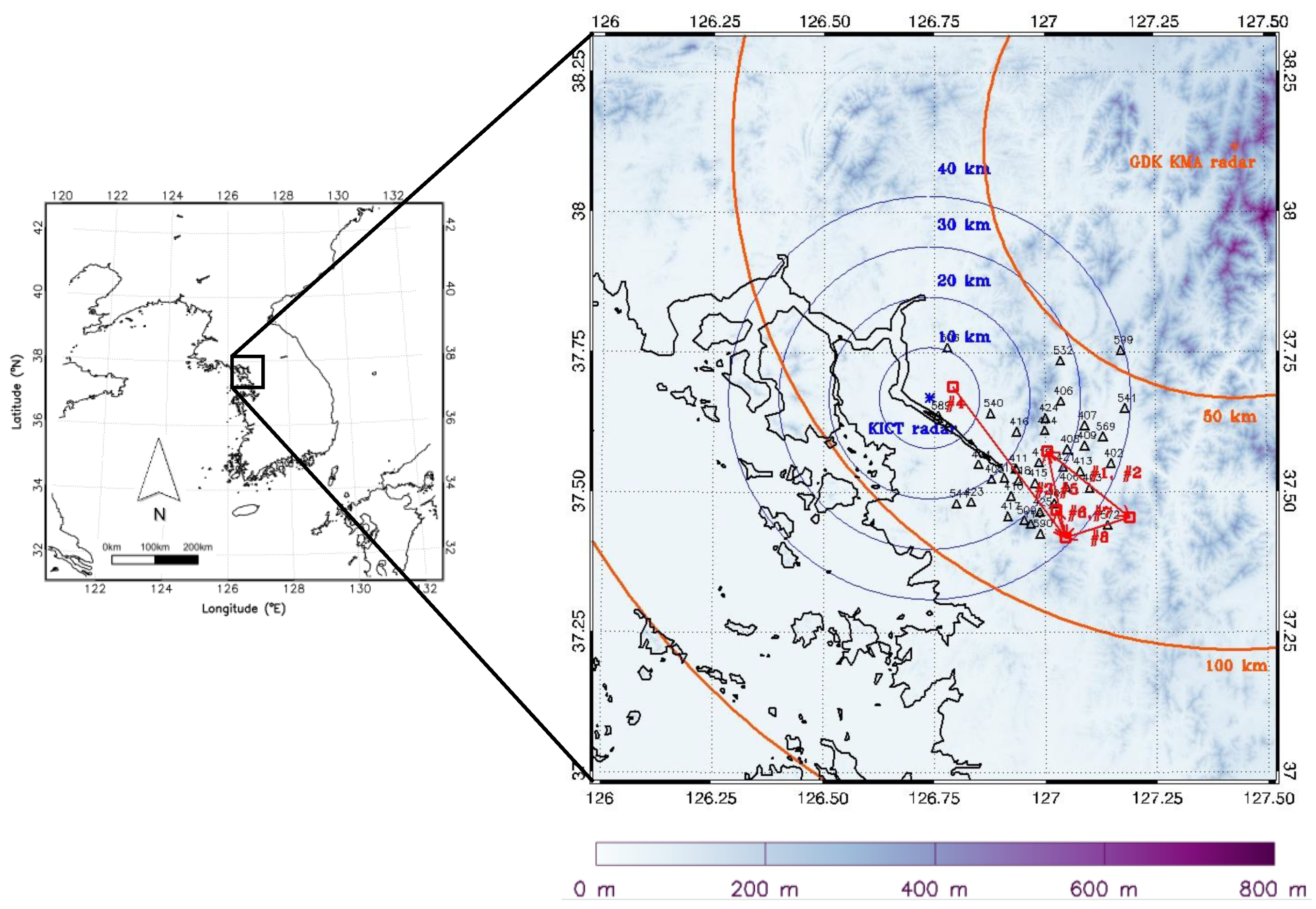
2. Materials
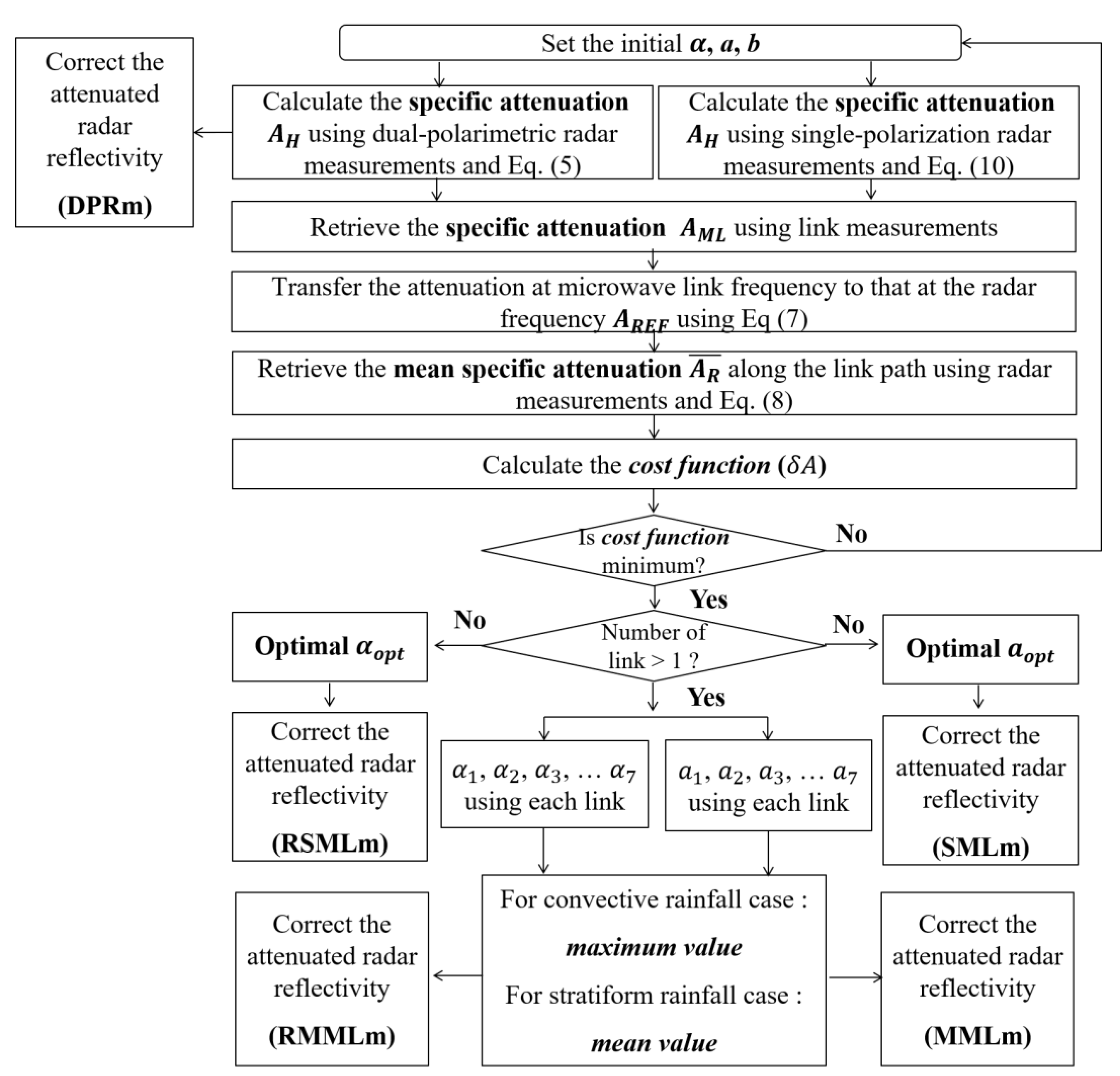
3. Methods
3.1. Attenuation Correction Using Dual-Polarimetric Radar
3.2. Attenuation Correction Using Microwave Link only
3.3. Assessment of the Performance of Correction Methods
4. Results
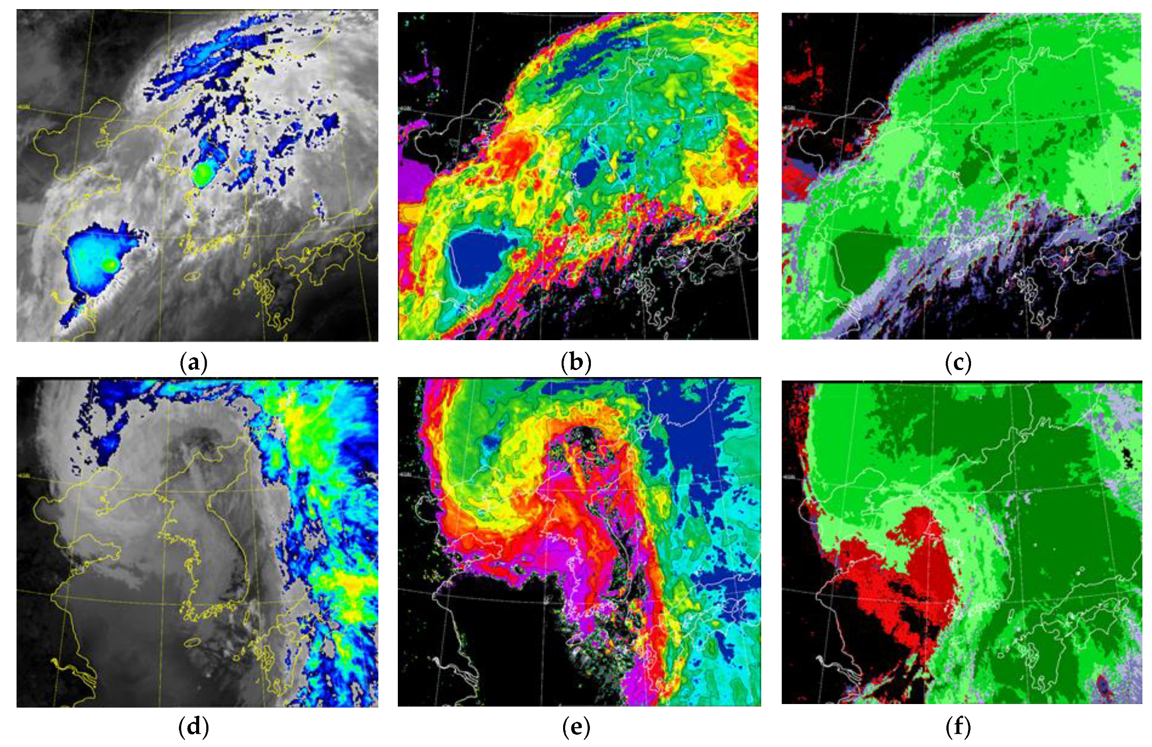
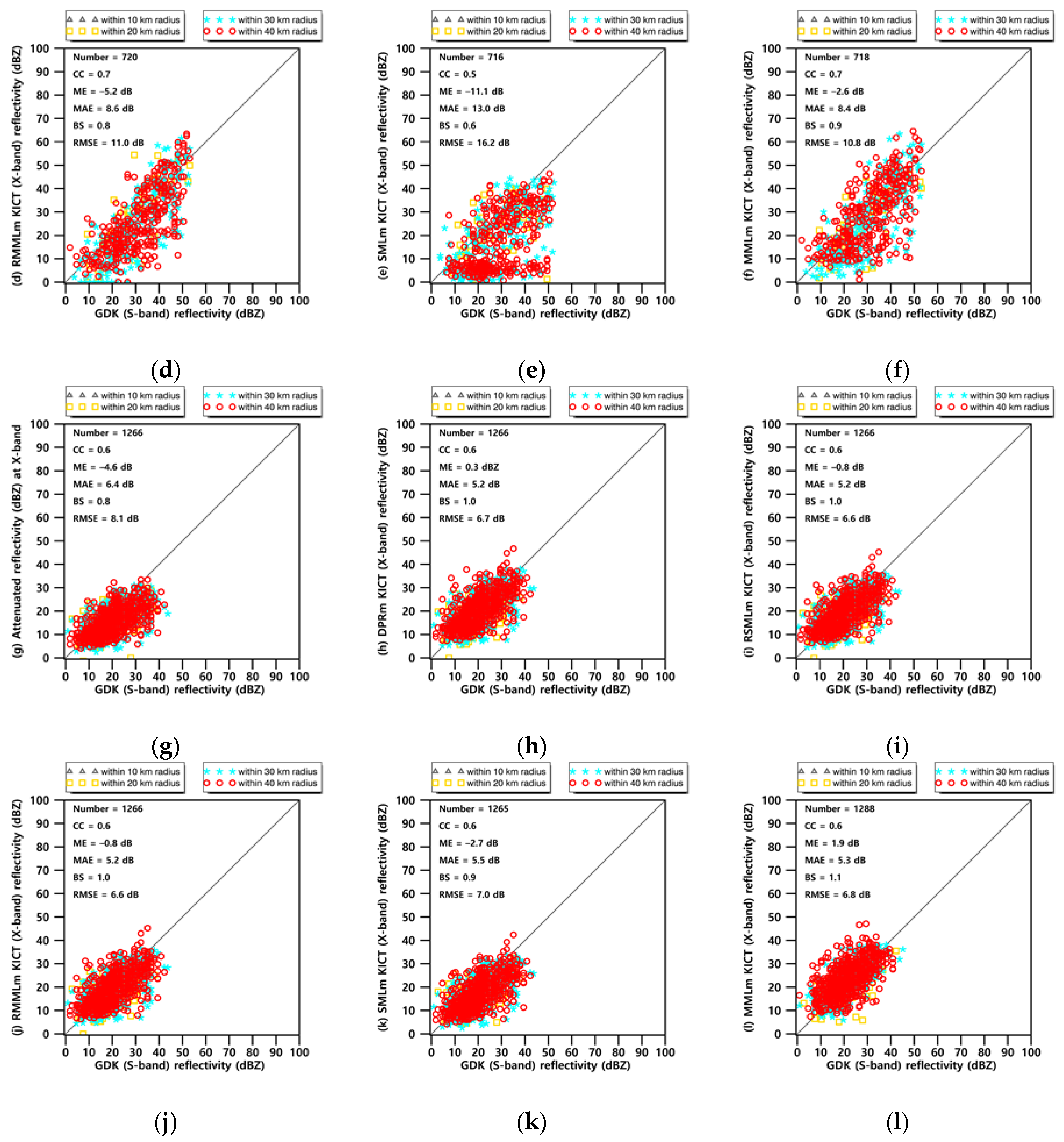
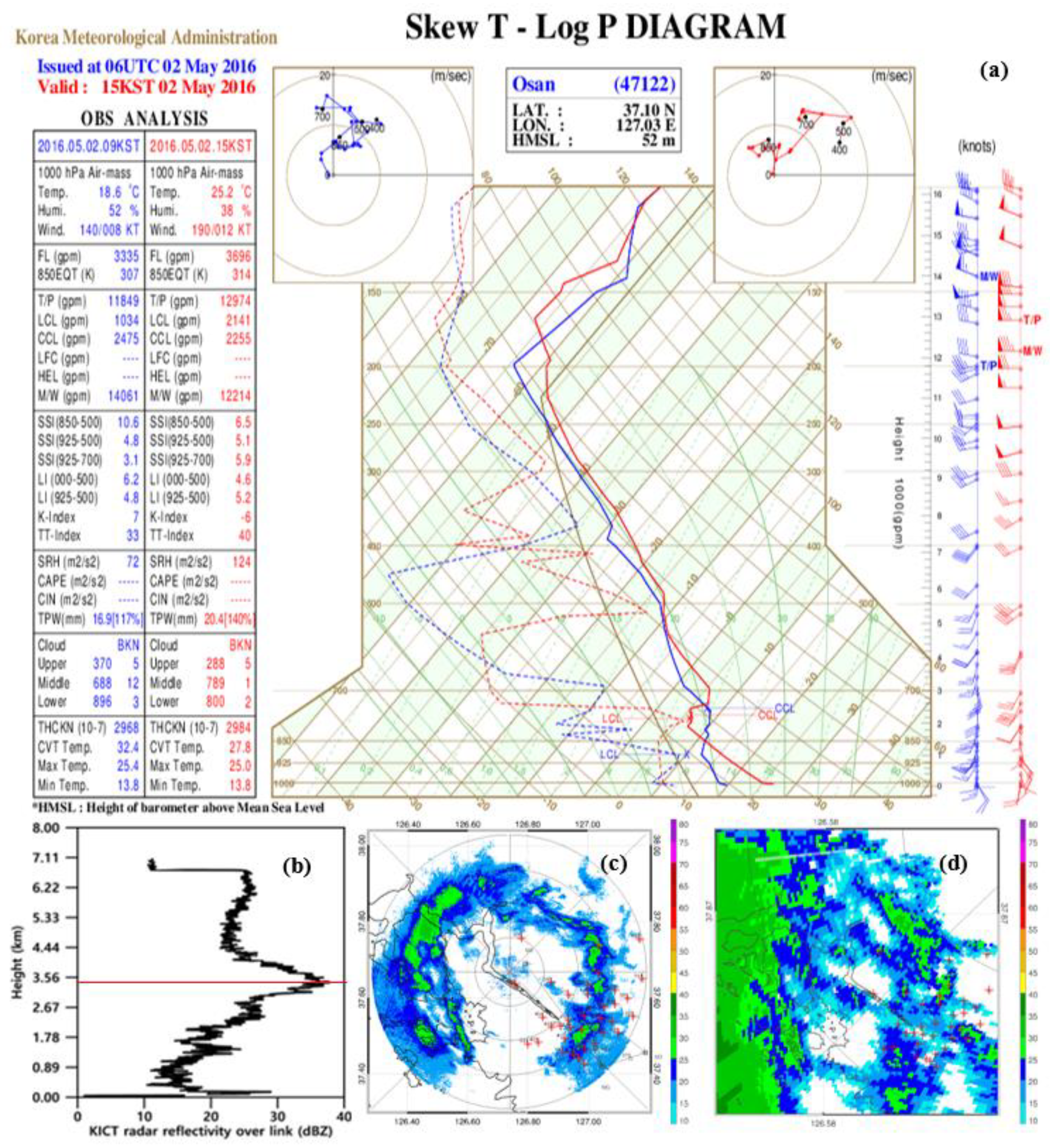
4.1. Reflectivity of Convective and Stratiform Rainfall
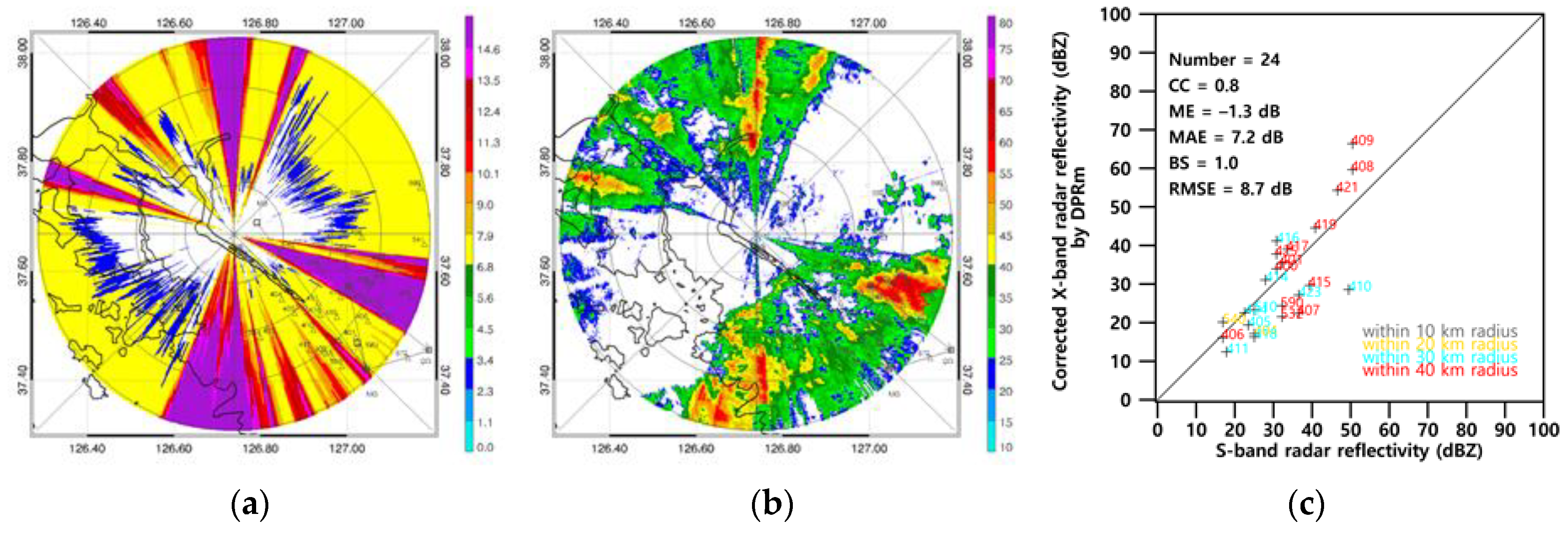
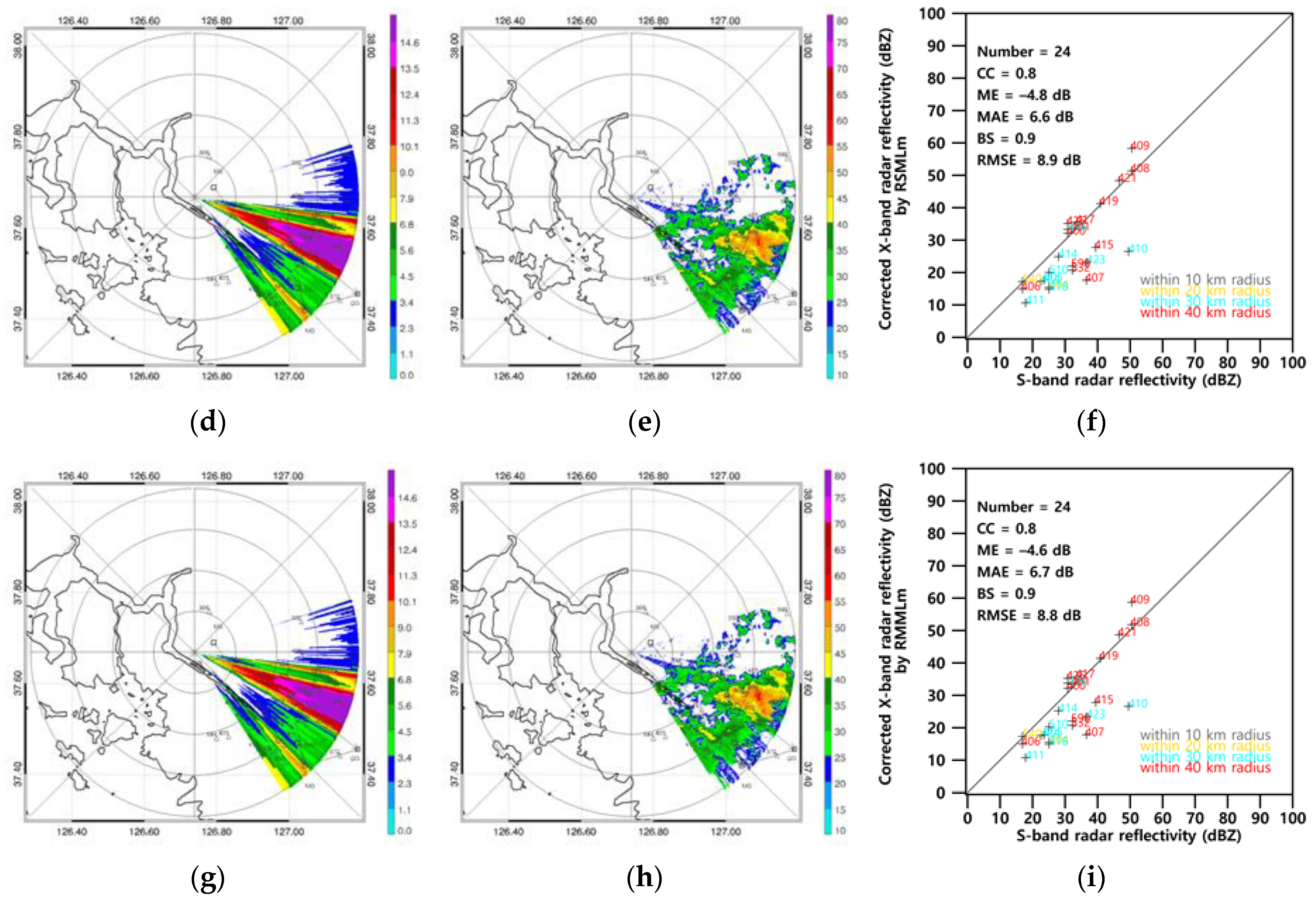
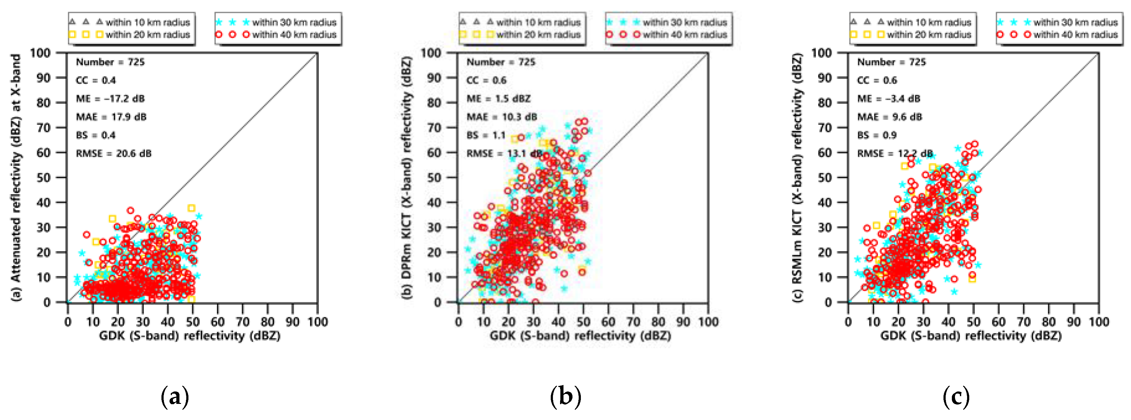
4.2. Attenuation Correction with a Dual-Polarimetric Radar
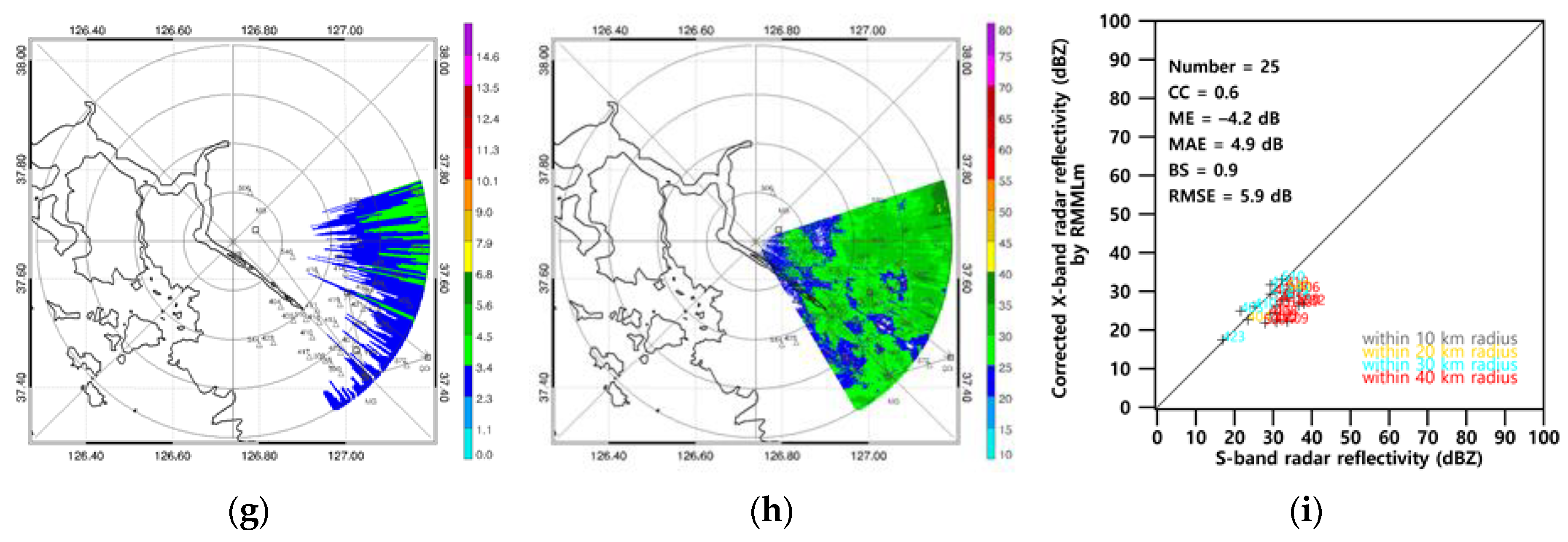
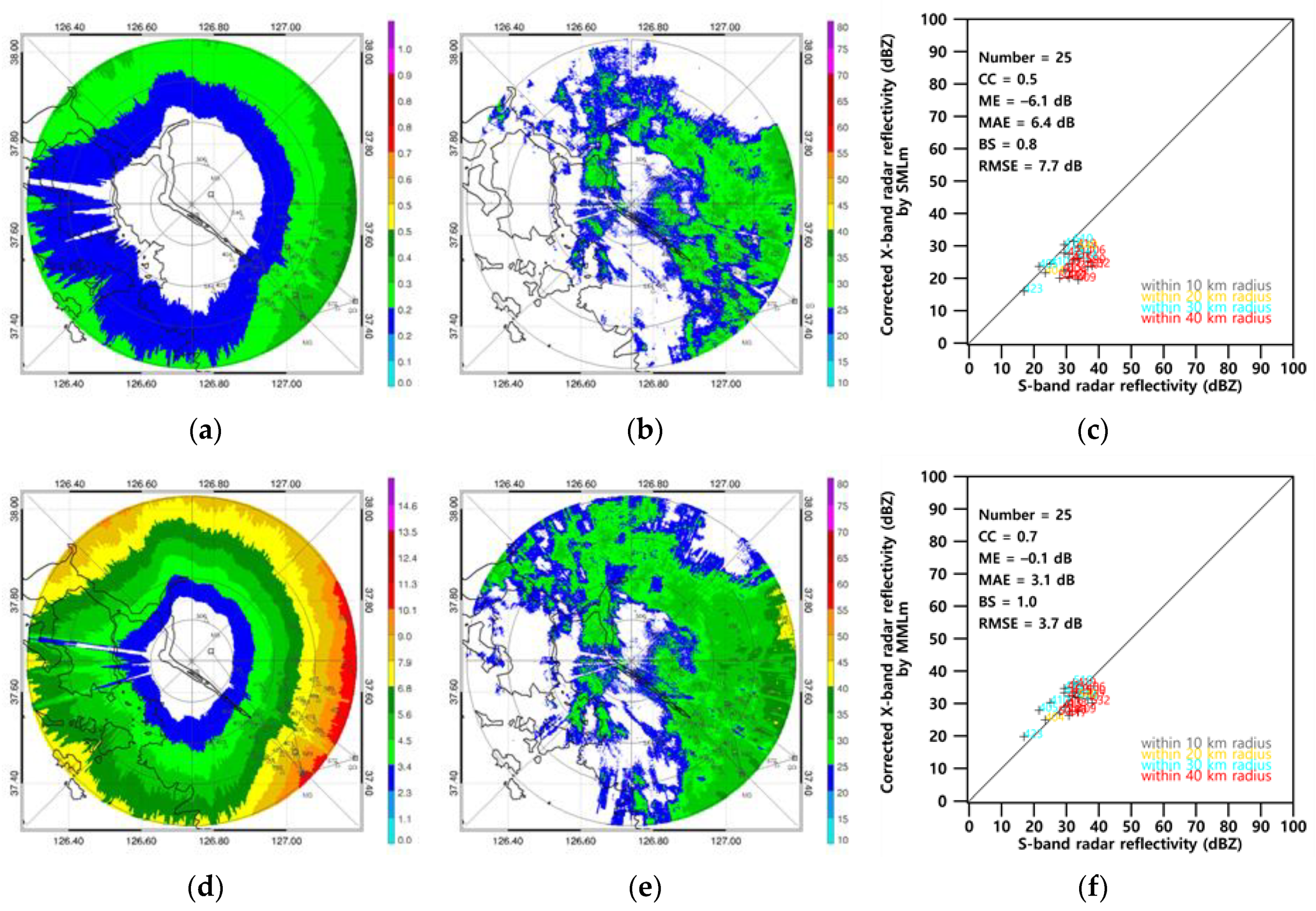
4.3. Attenuation Correction Using Microwave Link only
5. Discussion
6. Conclusions
Author Contributions
Funding
Acknowledgments
Conflicts of Interest
References
- Barthes, L.; Mallet, C. Rainfall measurement from the opportunistic use of an Earth-space link in the Ku band. Atmos. Meas. Tech. 2013, 6, 2181–2193. [Google Scholar] [CrossRef]
- Ojo, J.S.; Ajewole, M.O.; Emiliani, L.D. One-minute rain-rate contour maps for microwave-communication-system planning in a tropical country: Nigeria. IEEE Antennas Propag. Mag. 2009, 51, 82–89. [Google Scholar] [CrossRef]
- Olurotimi, E.; Sokoya, O.; Ojo, J.; Owolawi, P.A. Observation of bright-band height data from TRMM-PR for satellite communication in South Africa. J. Atmos. Sol.-Terr. Phys. 2017, 160, 24–33. [Google Scholar] [CrossRef]
- Atlas, D.; Banks, H.C. The interpretation of microwave reflections from rainfall. J. Meteorol. 1951, 8, 271–282. [Google Scholar] [CrossRef]
- Park, S.; Bringi, V.; Chandrasekar, V.; Maki, M.; Iwanami, K. Correction of radar reflectivity and differential reflectivity for rain attenuation at X band. Part I: Theoretical and empirical basis. J. Atmos. Ocean. Technol. 2005, 22, 1621–1632. [Google Scholar] [CrossRef]
- Testud, J.; Le Bouar, E.; Obligis, E.; Ali-Mehenni, M. The rain profiling algorithm applied to polarimetric weather radar. J. Atmos. Ocean. Technol. 2000, 17, 332–356. [Google Scholar] [CrossRef]
- Bringi, V.; Keenan, T.; Chandrasekar, V. Correcting C-band radar reflectivity and differential reflectivity data for rain attenuation: A self-consistent method with constraints. IEEE Trans. Geosci. Remote. Sens. 2001, 39, 1906–1915. [Google Scholar] [CrossRef]
- Kim, D.-S.; Maki, M.; Lee, D.-I. Correction of X-band radar reflectivity and differential reflectivity for rain attenuation using differential phase. Atmos. Res. 2008, 90, 1–9. [Google Scholar] [CrossRef]
- Kim, M.-S.; Kim, M.-S. Rainfall detection and rainfall rate estimation using microwave attenuation. Atmosphere 2018, 9, 287. [Google Scholar] [CrossRef]
- Kramer, S.; Verworn, H.-R.; Redder, A. Improvement of X-band radar rainfall estimates using a microwave link. Atmos. Res. 2005, 77, 278–299. [Google Scholar] [CrossRef]
- Rahimi, A.R.; Holt, A.R.; Upton, G.J.G.; Kramer, S.; Redder, A.; Verworn, H.-R. Attenuation calibration of an x-band weather radar using a microwave link. J. Atmos. Ocean. Technol. 2006, 23, 395–405. [Google Scholar] [CrossRef]
- Trömel, S.; Ziegert, M.; Ryzhkov, A.V.; Chwala, C.; Simmer, C. Using microwave backhaul links to optimize the performance of algorithms for rainfall estimation and attenuation correction. J. Atmos. Ocean. Technol. 2014, 31, 1748–1760. [Google Scholar] [CrossRef]
- Zhang, P.; Liu, X.; Li, Z.; Zhou, Z.; Song, K.; Yang, P. Attenuation correction of weather radar reflectivity with arbitrary oriented microwave link. Adv. Meteorol. 2017, 2017, 1–17. [Google Scholar] [CrossRef]
- Yoon, J.; Joo, J.; Yoo, C.; Hwang, S.; Lim, S. On quality of radar rainfall with respect to temporal and spatial resolution for application to urban areas. Meteorol. Appl. 2016, 24, 19–30. [Google Scholar] [CrossRef]
- Cha, J.; Han, H.; Park, J. Current state and future plan of quality control and quantitative precipitation estimation for KMA weather radar data. Mag. IEEK 2013, 40, 129–136. [Google Scholar]
- Baik, J.; Choi, M. Spatio-temporal variability of remotely sensed precipitation data from COMS and TRMM: Case study of Korean peninsula in East Asia. Adv. Space Res. 2015, 56, 1125–1138. [Google Scholar] [CrossRef]
- Hitschfeld, W.; Bordan, J. Errors inherent in the radar measurement of rainfall at attenuating wavelengths. J. Meteorol. 1954, 11, 58–67. [Google Scholar] [CrossRef]
- Snyder, J.C.; Bluestein, H.B.; Zhang, G.; Frasier, S. Attenuation correction and hydrometeor classification of high-resolution, X-band, dual-polarized mobile radar measurements in severe convective storms. J. Atmos. Ocean. Technol. 2010, 27, 1979–2001. [Google Scholar] [CrossRef]
- Bringi, V.N.; Chandrasekar, V. Polarimetric Doppler Weather Radar; Cambridge University Press (CUP): Cambridge, UK, 2001. [Google Scholar]
- Delrieu, G.; Caoudal, S.; Creutin, J.D. Feasibility of using mountain return for the correction of ground-based X-band weather radar data. J. Atmos. Ocean. Technol. 1997, 14, 368–385. [Google Scholar] [CrossRef]
- Carey, L.; Rutledge, S.A.; Ahijevych, D.A.; Keenan, T.D. Correcting propagation effects in C-band polarimetric radar observations of tropical convection using differential propagation phase. J. Appl. Meteorol. 2000, 39, 1405–1433. [Google Scholar] [CrossRef]
- Bringi, V.N.; Chandrasekar, V.; Balakrishnan, N.; Zrnic, D.S. An examination of propagation effects in rainfall on radar measurements at microwave frequencies. J. Atmos. Ocean. Technol. 1990, 7, 829–840. [Google Scholar] [CrossRef]
- Ryzhkov, A.V.; Diederich, M.; Zhang, P.; Simmer, C. Potential utilization of specific attenuation for rainfall estimation, mitigation of partial beam blockage, and radar networking. J. Atmos. Ocean. Technol. 2014, 31, 599–619. [Google Scholar] [CrossRef]
- Krämer, S.; Verworn, H. Improved C-band radar data processing for real time control of urban drainage systems. In Proceedings of the 11th International Conference on Urban Drainage, Edinburgh, UK, 31 August–5 September 2008. [Google Scholar]
- Press, W.H.; Teukolsky, S.A.; Vetterling, W.T.; Flannery, B.P. Golden section search in one dimension. In Numerical Recipes in C: The Art of Scientific Computing; Cambridge University Press: Cambridge, UK, 1992. [Google Scholar]
- Gunn, K.L.S.; East, T.W.R. The microwave properties of precipitation particles. Q. J. R. Meteorol. Soc. 1954, 80, 522–545. [Google Scholar] [CrossRef]
- Delrieu, G.; Andrieu, H.; Creutin, J.-D. Quantification of path-integrated attenuation for X- and C-band weather radar systems operating in mediterranean heavy rainfall. J. Appl. Meteorol. 2000, 39, 840–850. [Google Scholar] [CrossRef]
- Feng, L.; Xiao, H.; Wen, G.; Li, Z.; Sun, Y.; Tang, Q.; Liu, Y. Rain attenuation correction of reflectivity for X-band dual-polarization radar. Atmosphere 2016, 7, 164. [Google Scholar] [CrossRef]
- Le Loh, J.; Lee, D.-I.; Kang, M.-Y.; You, C.-H. Classification of rainfall types using parsivel disdrometer and S-band polarimetric radar in central Korea. Remote. Sens. 2020, 12, 642. [Google Scholar] [CrossRef]
- Anagnostou, E.N. A convective/stratiform precipitation classification algorithm for volume scanning weather radar observations. Meteorol. Appl. 2004, 11, 291–300. [Google Scholar] [CrossRef]
- Uijlenhoet, R.; Steiner, M.; Smith, J.A. Variability of raindrop size distributions in a squall line and implications for radar rainfall estimation. J. Hydrometeorol. 2003, 4, 43–61. [Google Scholar] [CrossRef]
- Oh, Y.-A.; Lee, D.; Jung, S.-H.; Nam, K.-Y. Attenuation correction effects in rainfall estimation at X-band dual-polarization radar: Evaluation with a dense rain gauge network. Adv. Meteorol. 2016, 2016, 1–20. [Google Scholar] [CrossRef][Green Version]
- Leijnse, H.; Uijlenhoet, R.; Stricker, J. Microwave link rainfall estimation: Effects of link length and frequency, temporal sampling, power resolution, and wet antenna attenuation. Adv. Water Resour. 2008, 31, 1481–1493. [Google Scholar] [CrossRef]
- Cunningham, J.G.; Zittel, W.D.; Lee, R.R.; Ice, R.L.; Hoban, N.P. Methods for identifying systematic differential reflectivity (ZDR) biases on the operational WSR-88D network. In Proceedings of the 36th Conference on Radar Meteorology, Breckenridge, CO, USA, 16–20 September 2013. [Google Scholar]


| KICT Radar | GDK Radar | |
|---|---|---|
| Band | Dual-polarimetric | Single-polarization |
| Location | 37.67° N, 126.74° E | 38.1173° N, 127.4336° E |
| Transmitter type | Magnetron | Klystron |
| Frequency | 9410 ± 30 MHz | 2887 MHz |
| Pulse width | 0.6 μsec | 0.8 μsec and 4.5 μsec |
| Pulse repetition frequency | 2000 Hz | 250–1200 Hz |
| Gain | 41 dB | 45 dB |
| Beam width | 1.4° | 1° |
| Time resolution | 1 min | 10 min |
| Spatial resolution | 60 m 60 m | 250 m 250 m |
| Antenna polarization | Simultaneous H/V | Simultaneous H |
| Effective observation range | 40 km | 240 km |
| Antenna diameter | 1.8 m | 8.5 m |
| Link | Frequency (GHz) | Nearest AWS | Distance (km) from KICT | KICT Azimuth (°) | Link Length (km) | ||
|---|---|---|---|---|---|---|---|
| Transmitter | Receiver | Transmitter | Receiver | ||||
| #1 | 7.75 | 413 | 46.37 | 25.56 | 113 | 110 | 21.1 |
| #2 | 8.06 | 419 | 25.56 | 46.37 | 110 | 113 | 21.1 |
| #3 | 7.95 | 421 | 25.80 | 38.50 | 110 | 136 | 17.6 |
| #4 | 6.23 | 425 | 38.50 | 4.95 | 136 | 80 | 37.4 |
| #5 | 8.26 | 401 | 38.50 | 25.80 | 136 | 110 | 17.6 |
| #6 | 6.06 | 401 | 33.66 | 38.49 | 136 | 130 | 5.7 |
| #7 | 6.32 | 401 | 38.49 | 33.66 | 130 | 136 | 5.7 |
| Method | DPRm [6] | RSMLm [13] | RMMLm | SMLm [10] | MMLm | |
|---|---|---|---|---|---|---|
| Required Instruments | Dual-Polarimetric Radar | Dual-Polarimetric Radar, Single Microwave link | Dual-Polarimetric Radar, Multiple Microwave link | Radar, Single Microwave Link | Radar, Multiple Microwave Link | |
| AH | ||||||
| AREF | - | |||||
| - | ||||||
| Cost function | - | |||||
| Constant | ||||||
| Variable (initial value) | , | , | ||||
| AWS Site | KICT RBH (km) | GDK RBH (km) /Elevation (˚) | AWS Site | KICT RBH (km) | GDK RBH (km) /Elevation (˚) | AWS Site | KICT RBH (km) | GDK RBH (km) /Elevation (˚) |
|---|---|---|---|---|---|---|---|---|
| 116 | 2.8 | 2.7/1.0 | 411 | 2.0 | 2.2/0.6 | 506 | 0.9 | 1.3/0.0 |
| 400 | 2.9 | 2.6/1.0 | 413 | 2.9 | 2.6/1.0 | 509 | 2.6 | 2.7/1.0 |
| 401 | 2.9 | 2.8/1.0 | 414 | 2.1 | 2.0/0.6 | 510 | 1.9 | 1.8/0.3 |
| 402 | 3.4 | 3.3/1.7 | 415 | 2.4 | 2.2/0.6 | 532 | 2.3 | 2.1/1.0 |
| 403 | 3.2 | 3.5/1.7 | 416 | 1.6 | 1.5/0.2 | 540 | 1.2 | 1.3/0.0 |
| 404 | 1.5 | 1.4/0.0 | 417 | 2.4 | 2.3/0.6 | 541 | 3.3 | 2.9/1.7 |
| 405 | 1.9 | 1.9/0.3 | 418 | 2.2 | 2.3/0.6 | 544 | 1.9 | 2.0/0.3 |
| 406 | 2.2 | 2.3/1.0 | 419 | 2.2 | 2.1/0.6 | 569 | 3.2 | 3.1/1.7 |
| 407 | 2.8 | 3.1/1.7 | 421 | 2.7 | 2.6/1.0 | 572 | 3.5 | 3.7/1.7 |
| 408 | 2.6 | 2.5/1.0 | 423 | 2.0 | 1.9/0.3 | 589 | 0.3 | 1.4/0.0 |
| 409 | 2.9 | 3.2/1.7 | 424 | 1.9 | 1.9/0.6 | 590 | 3.2 | 2.9/1.0 |
| 410 | 2.3 | 2.3/0.6 | 425 | 2.9 | 2.8/1.0 | 599 | 3.4 | 2.4/1.7 |
© 2020 by the authors. Licensee MDPI, Basel, Switzerland. This article is an open access article distributed under the terms and conditions of the Creative Commons Attribution (CC BY) license (http://creativecommons.org/licenses/by/4.0/).
Share and Cite
Kim, M.-S.; Kwon, B.H. Attenuation Correction of X-Band Radar Reflectivity Using Adjacent Multiple Microwave Links. Remote Sens. 2020, 12, 2133. https://doi.org/10.3390/rs12132133
Kim M-S, Kwon BH. Attenuation Correction of X-Band Radar Reflectivity Using Adjacent Multiple Microwave Links. Remote Sensing. 2020; 12(13):2133. https://doi.org/10.3390/rs12132133
Chicago/Turabian StyleKim, Min-Seong, and Byung Hyuk Kwon. 2020. "Attenuation Correction of X-Band Radar Reflectivity Using Adjacent Multiple Microwave Links" Remote Sensing 12, no. 13: 2133. https://doi.org/10.3390/rs12132133
APA StyleKim, M.-S., & Kwon, B. H. (2020). Attenuation Correction of X-Band Radar Reflectivity Using Adjacent Multiple Microwave Links. Remote Sensing, 12(13), 2133. https://doi.org/10.3390/rs12132133