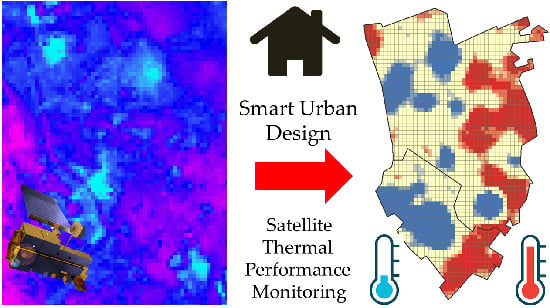
Satellite Monitoring of Thermal Performance in Smart Urban Designs

Abstract
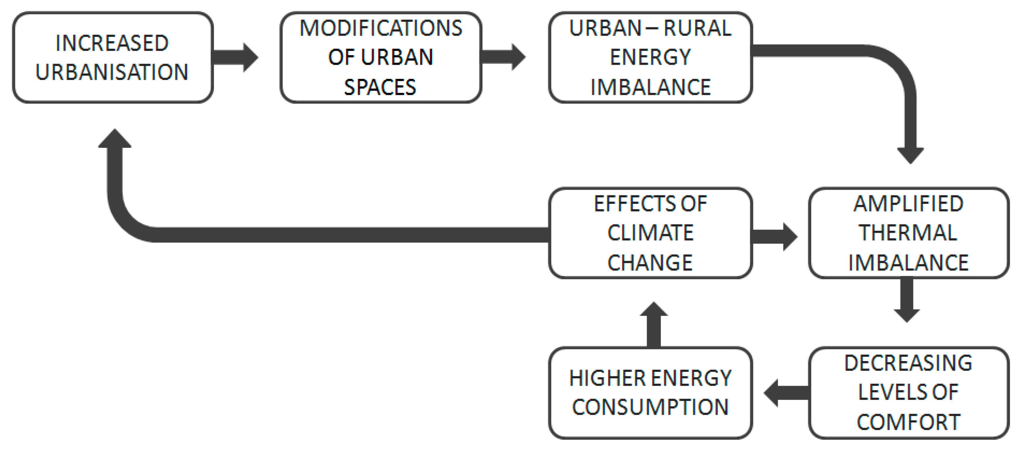
1. Introduction
2. Study Area, Materials, and Methods
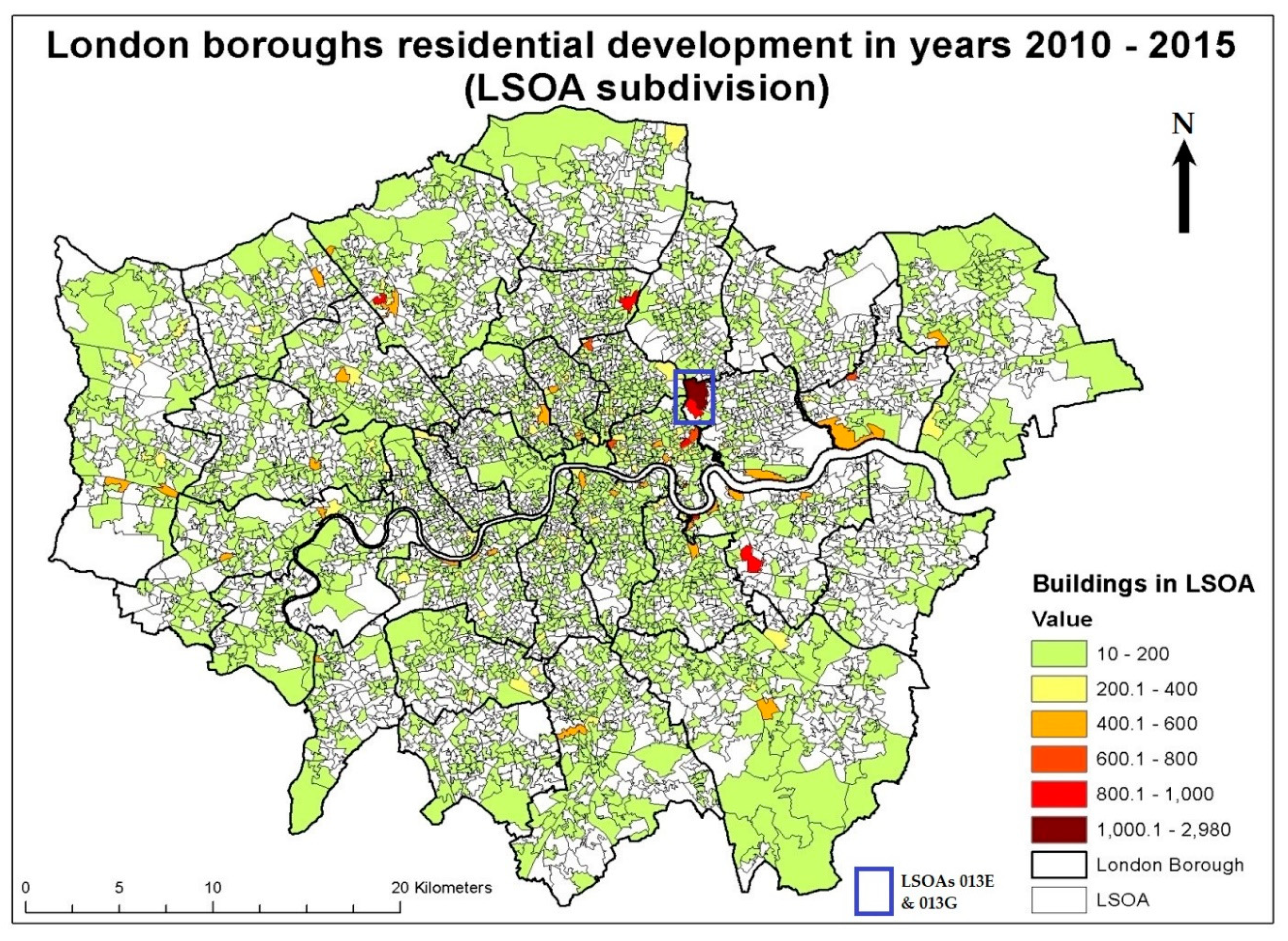
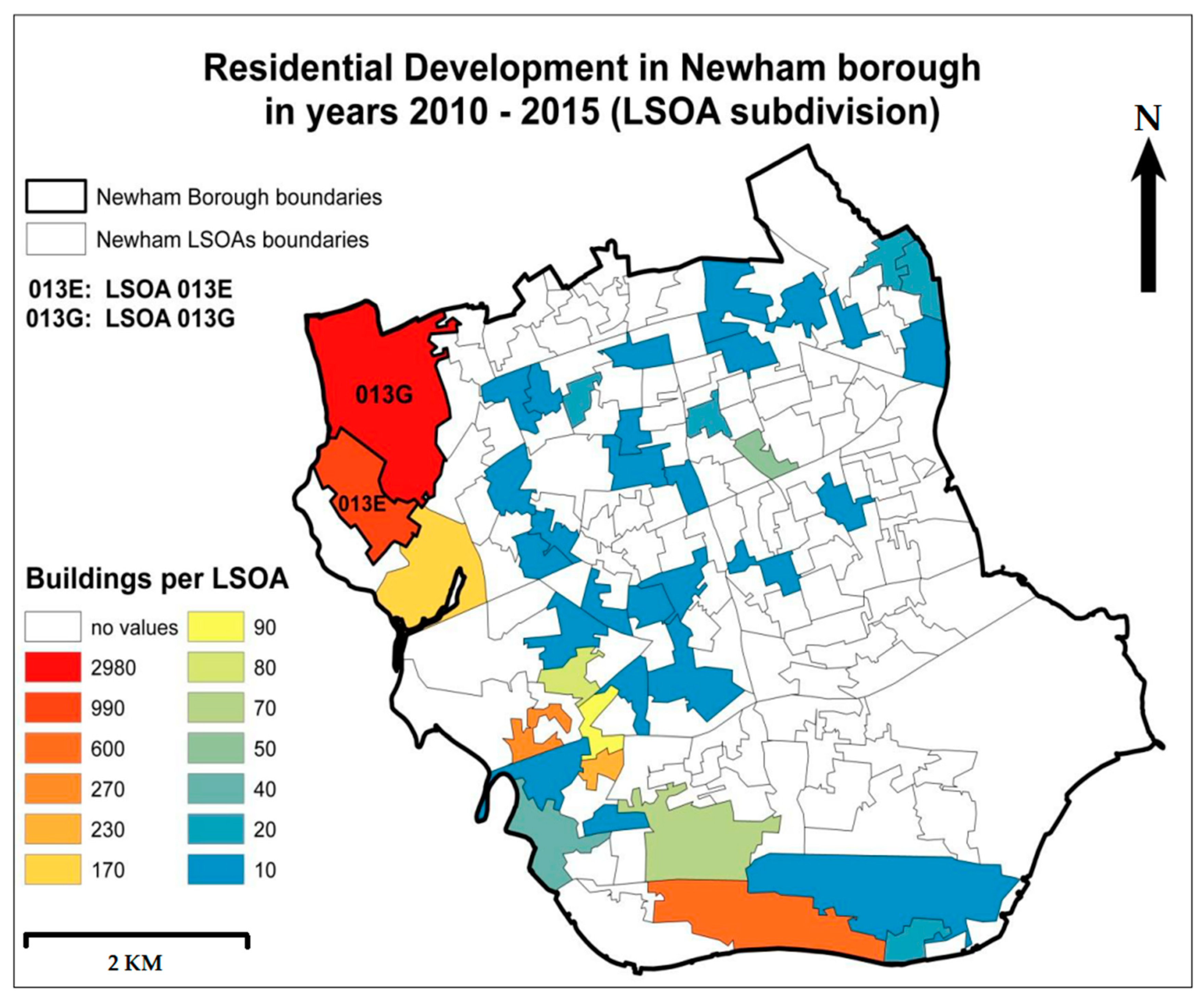
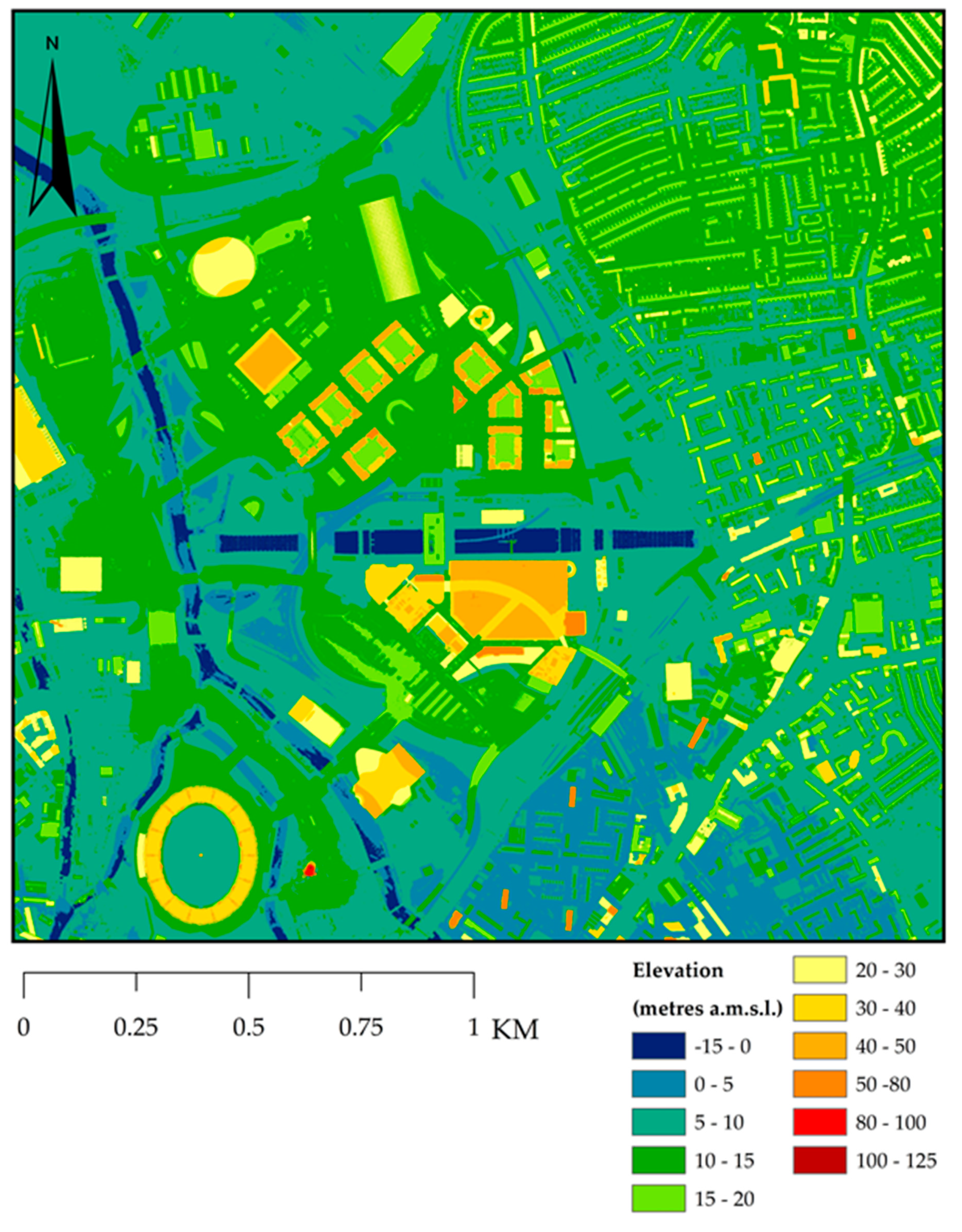
2.1. Choice of Study Area
2.2. Datasets Used for Land Surface Temperature Retrieval
2.3. Land Surface Temperature Calculation
2.4. Transmittance Estimation
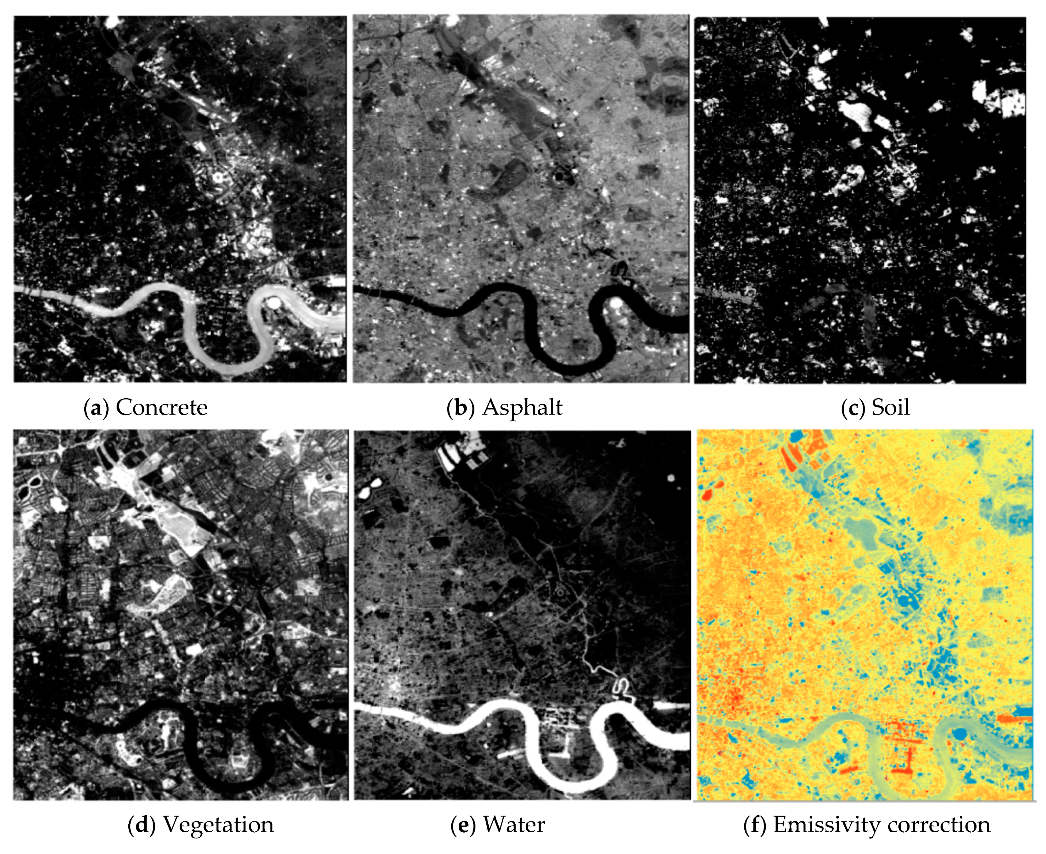
2.5. Emissivity Estimation
2.6. Identification of Potential Surface Urban Heat Island (SUHI) Areas
2.7. Validation of LST Calculations
3. Results
3.1. Emissivity Correction
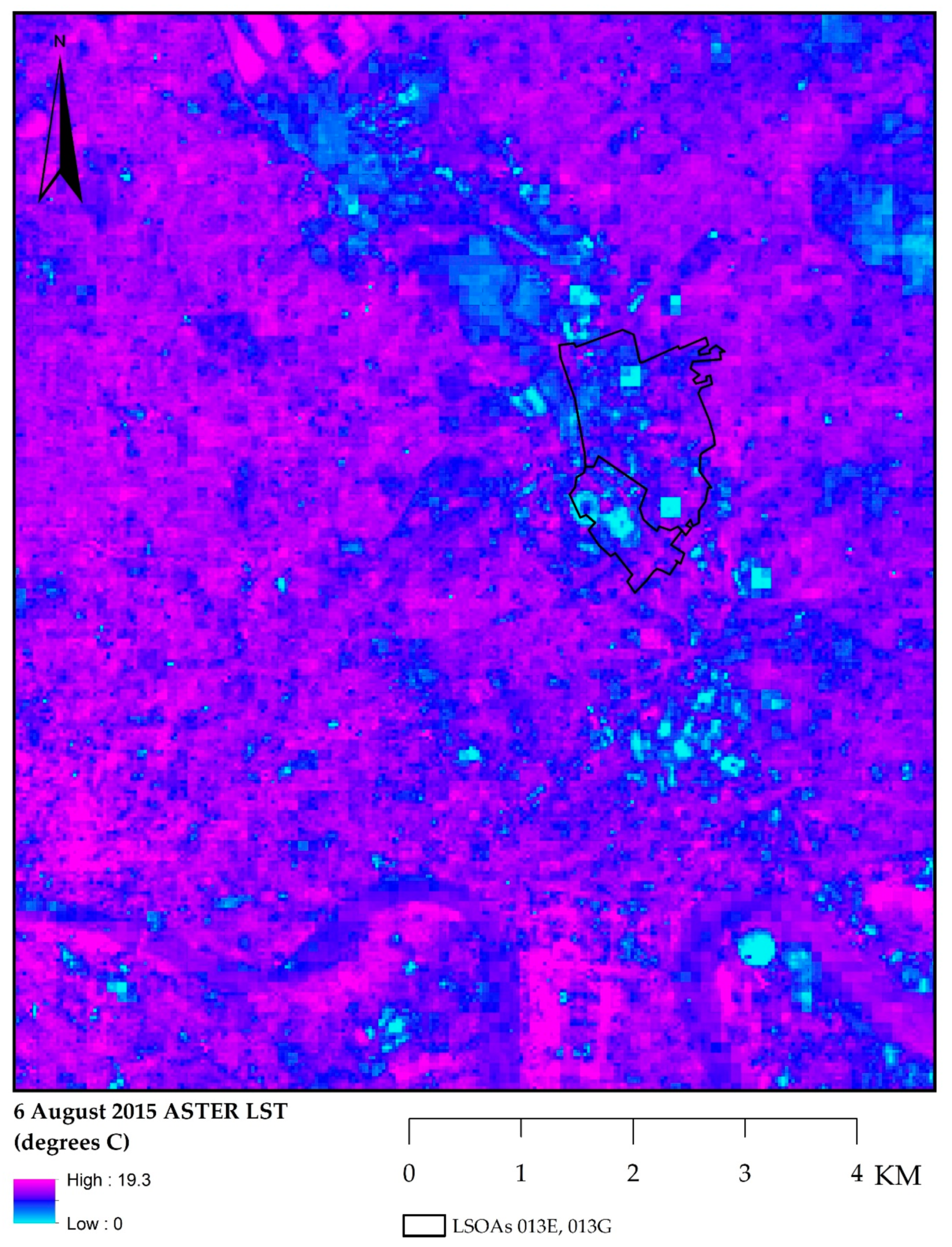
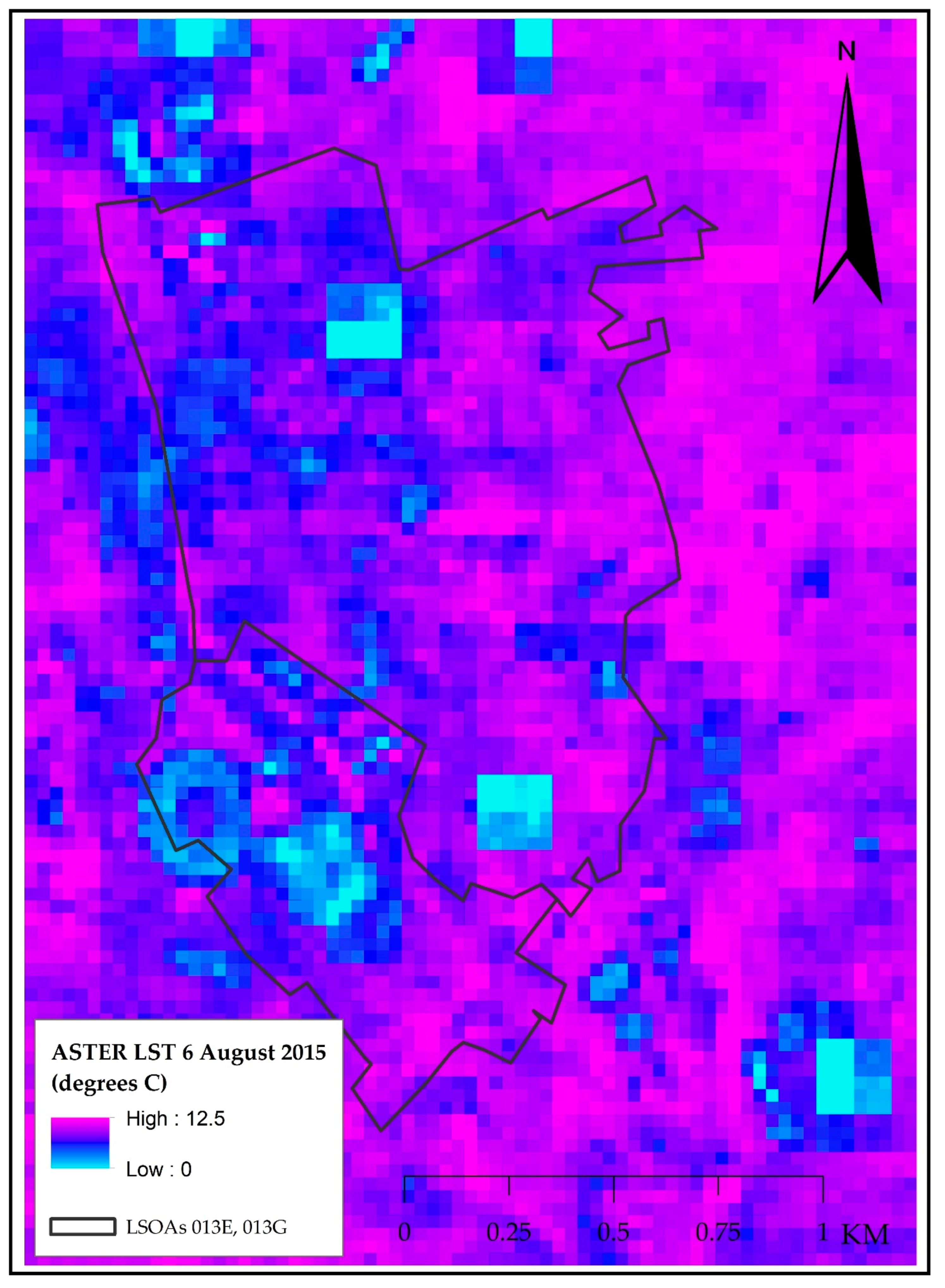
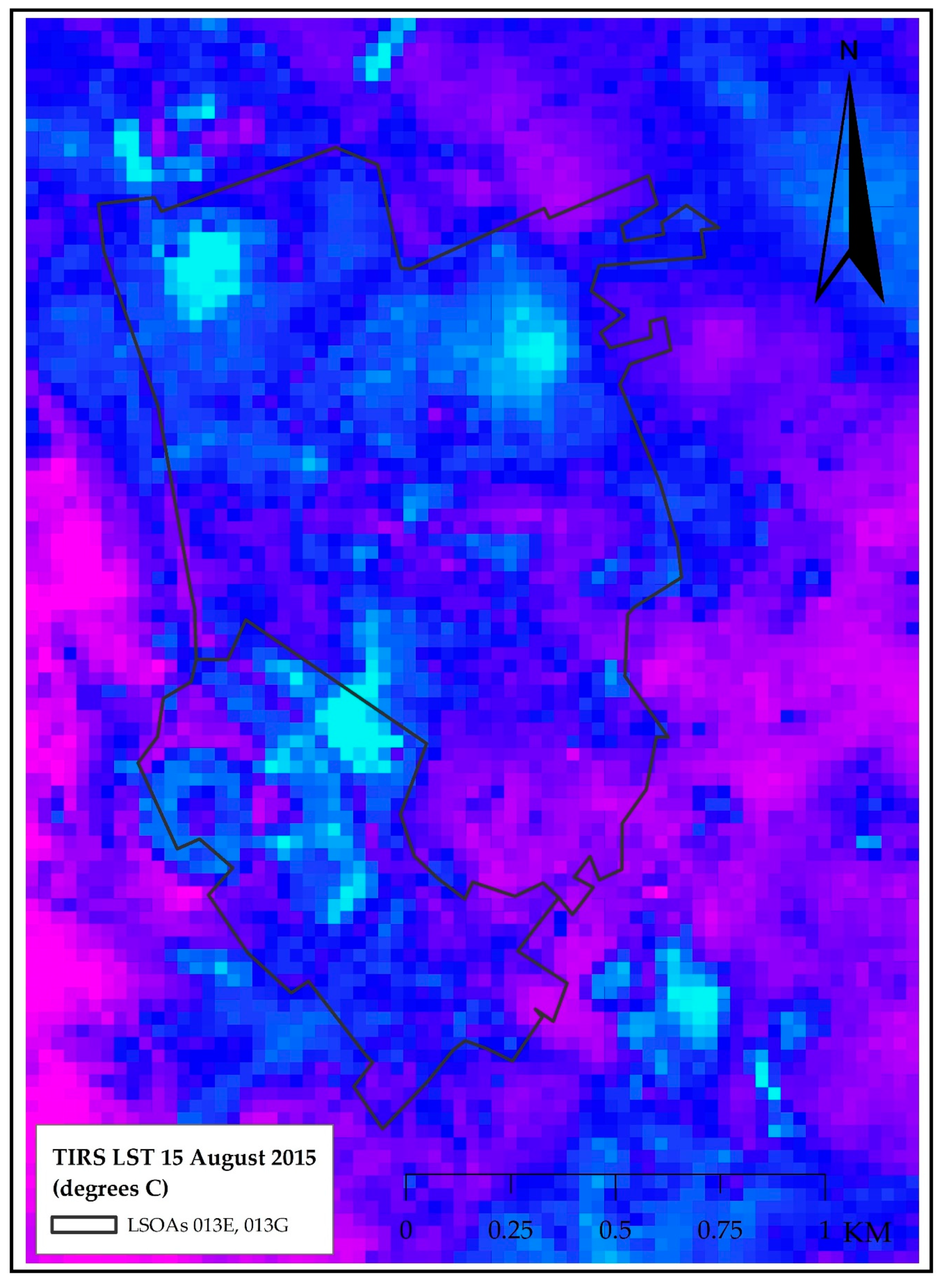
3.2. Land Surface Temperature Calculation and Validation
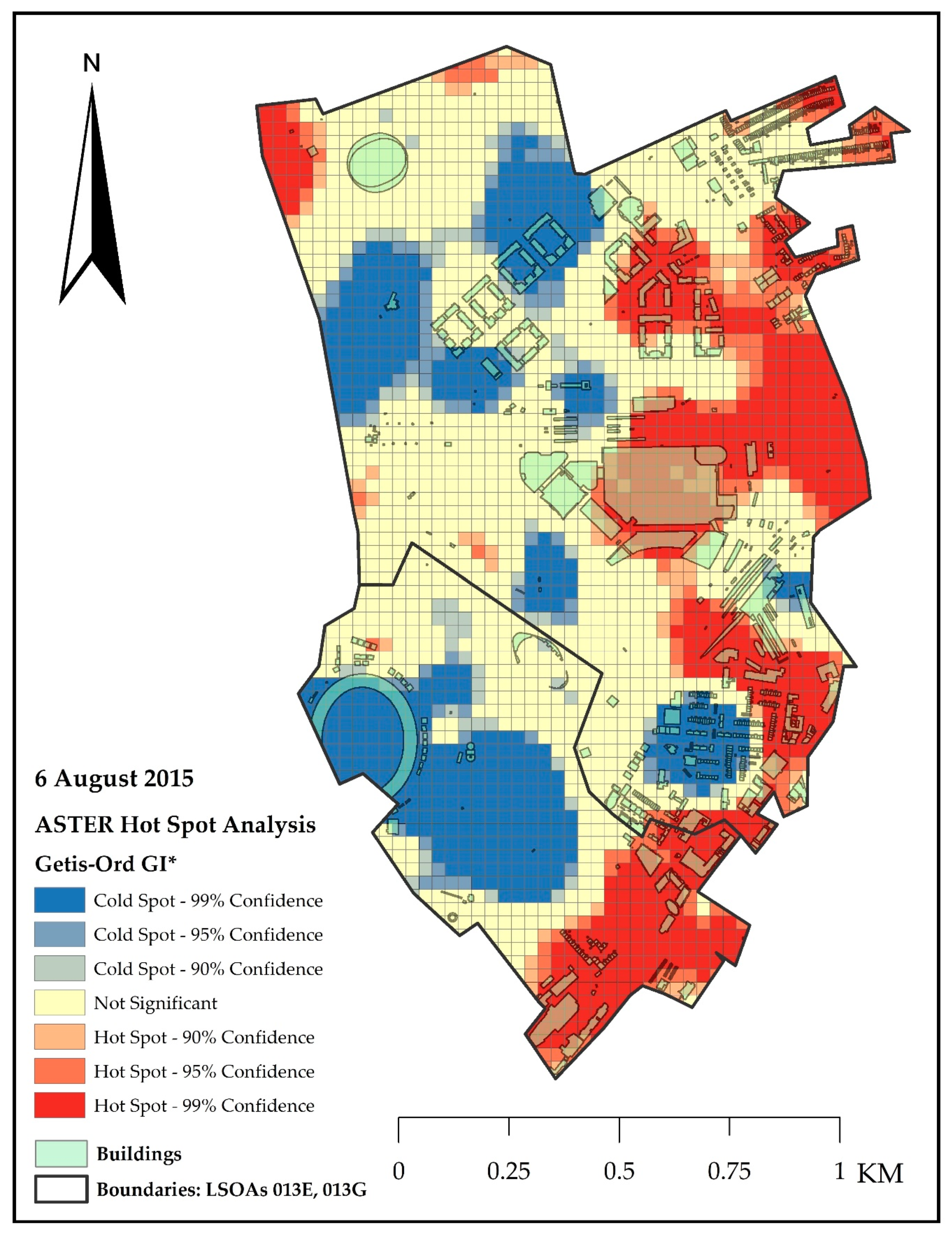
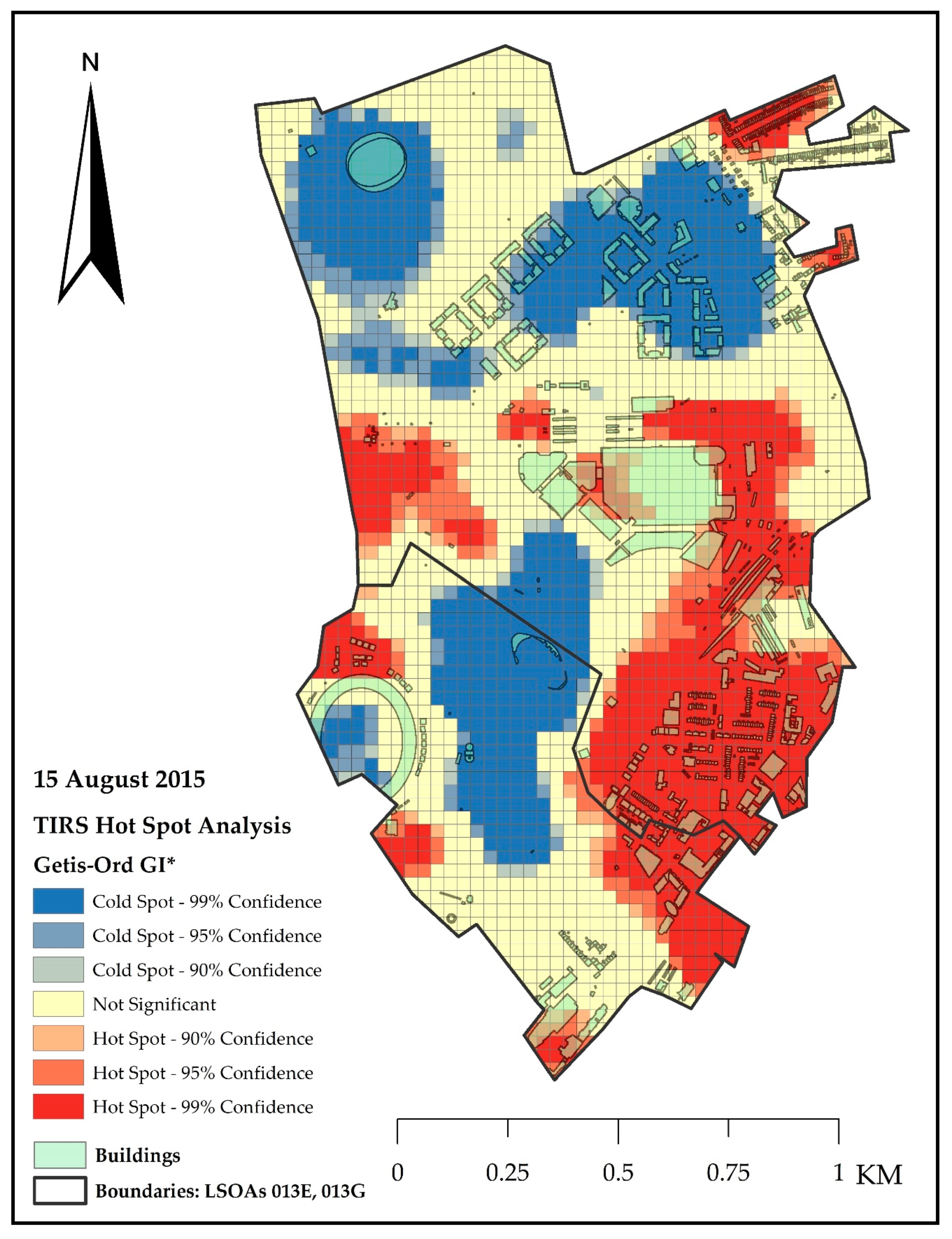
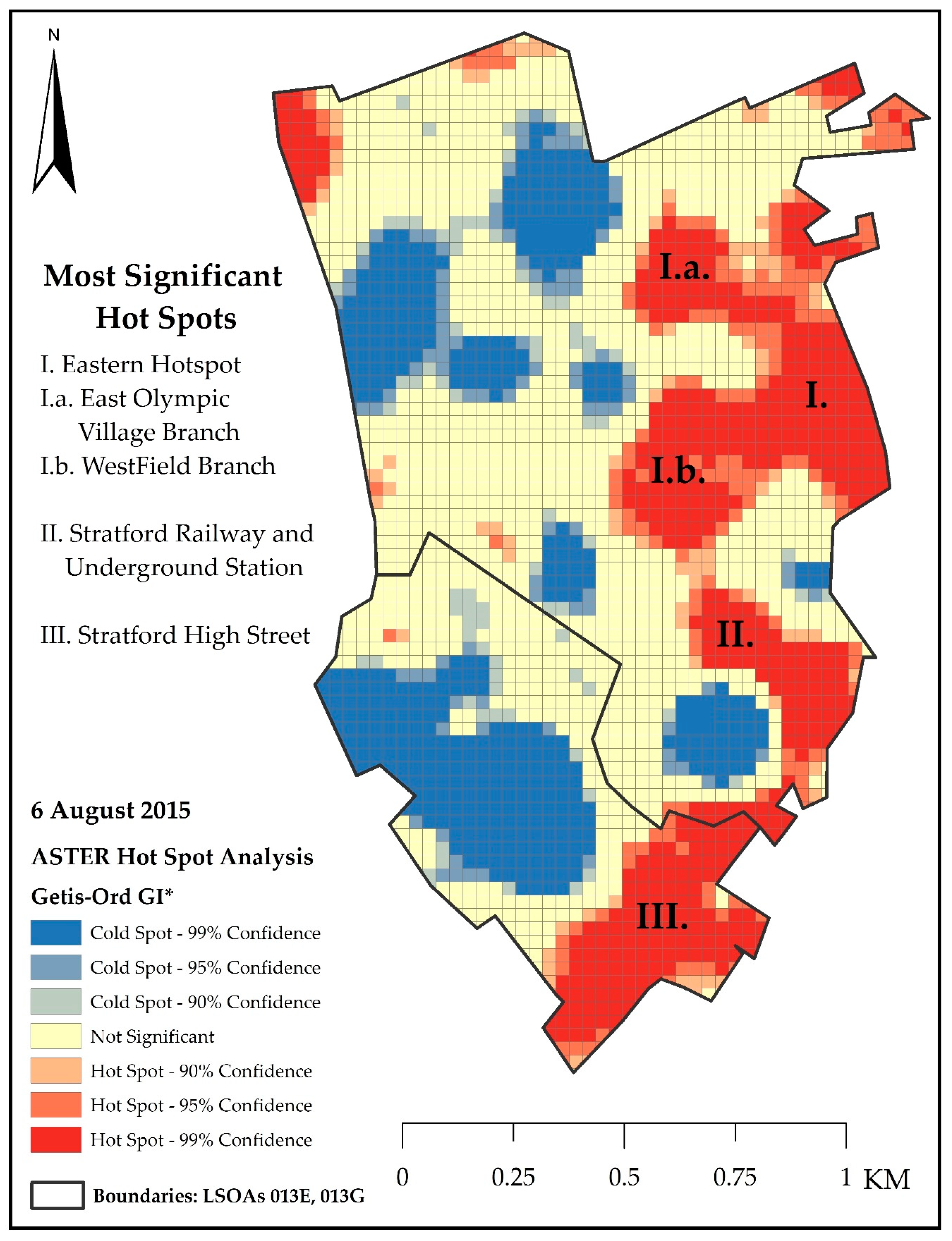
3.3. Identification of Potential Surface Urban Heat Island (SUHI) Areas
4. Discussion
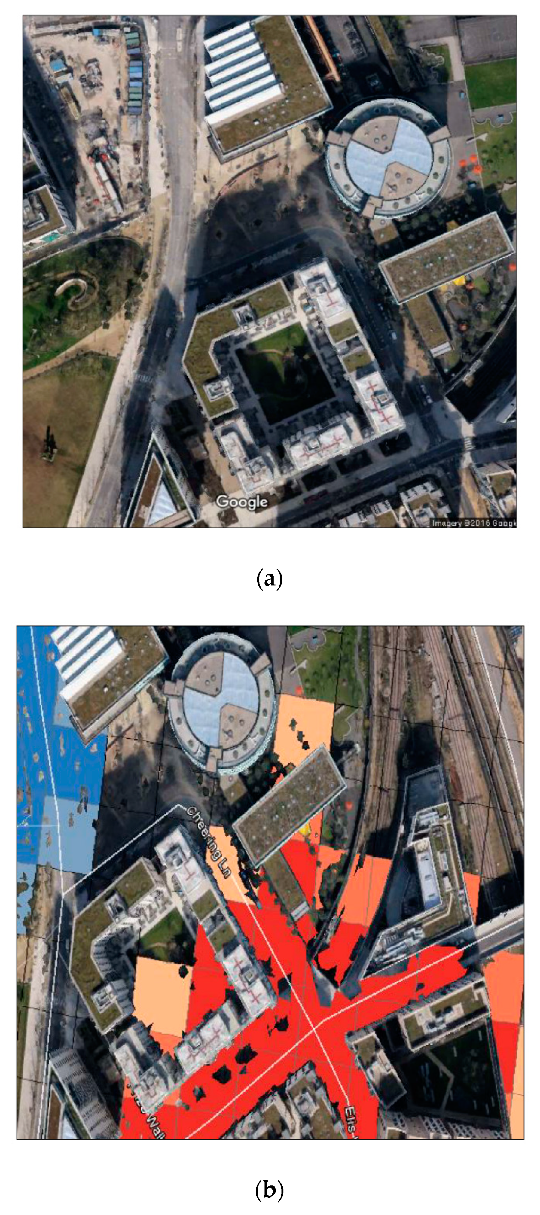
4.1. Identification of Newly Built Areas
4.2. Calculation of Land Surface Temperature (LST)
4.3. Identification of Potential Surface Urban Heat Island (SUHI) Areas
5. Conclusions
Author Contributions
Funding
Acknowledgments
Conflicts of Interest
References
- Barlow, J.F.; Halios, C.H.; Lane, S.E.; Wood, C.R. Observations of urban boundary layer structure during a strong urban heat island event. Environ. Fluid Mech. 2015, 15, 373–398. [Google Scholar] [CrossRef]
- Zhang, Y.; Cheng, J. Spatio-Temporal Analysis of Urban Heat Island Using Multisource Remote Sensing Data: A Case Study in Hangzhou, China. IEEE J. Sel. Top. Appl. Earth Obs. Remote Sens. 2019. [Google Scholar] [CrossRef]
- Voogt, J.A.; Oke, T.R. Thermal remote sensing of urban climates. Remote Sens. Environ. 2003, 86, 370–384. [Google Scholar] [CrossRef]
- Palme, M.; Inostroza, L.; Villacreses, G.; Lobato-Cordero, A.; Carrasco, C. From urban climate to energy consumption. Enhancing building performance simulation by including the urban heat island effect. Energy Build. 2017, 145, 107–120. [Google Scholar] [CrossRef]
- Oke, T.R. The heat island of the urban boundary layer: Characteristics, causes and effects. Wind Clim. Cities 1995, 277, 81–107. [Google Scholar] [CrossRef]
- Voogt, J.A.; Oke, T.R. Complete urban surface temperatures. J. Appl. Meteorol. 1997, 36, 117–1132. [Google Scholar] [CrossRef]
- Rao, P.K. Remote sensing of urban heat islands from an environmental satellite. Bull. Am. Meteorol. Soc. 1972, 53, 647–648. [Google Scholar]
- Zhou, D.; Xiao, J.; Berger, C.; Deilami, K.; Zhou, Y.; Frolking, S.; Yao RQiao, Z.; Sobrino, J.A. Satellite Remote Sensing of Surface Urban Heat Islands: Progress, Challenges, and Perspectives. Remote Sens. 2018, 11, 48. [Google Scholar] [CrossRef]
- Koomen, E.; Diogo, V. Assessing potential future urban heat island patterns following climate scenarios, socio-economic developments and spatial planning strategies. Mitig. Adapt. Strateg. Glob. Chang. 2017, 22, 287–306. [Google Scholar] [CrossRef]
- Oke, T.R. The energetic basis of the urban heat island. Quart. J. R. Meteorol. Soc. 1982, 108, 1–24. [Google Scholar] [CrossRef]
- Ichinose, T.; Shimodozono, K.; Hanaki, K. Impact of anthropogenic heat on urban climate in Tokyo. Atmos. Environ. 1999, 33, 3897–3909. [Google Scholar] [CrossRef]
- Watkins, R. The Impact of the Urban Environment on the Energy Used for Cooling Buildings. Ph.D. Thesis, Brunel University, Uxbridge, London, UK, 2002. Available online: http://citeseerx.ist.psu.edu/viewdoc/download?doi=10.1.1.425.8093&rep=rep1&type=pdf (accessed on 2 September 2019).
- Eliasson, I.; Svensson, M.K. Spatial air temperature variations and urban land use—Statistical approach. Meteorol. Applic. 2013, 10, 135–149. [Google Scholar] [CrossRef]
- Oke, T.R. Canyon Geometry and the Nocturnal Urban Heat-Island—Comparison of Scale Model and Field Observations. Int. J. Climatol. 1981, 1, 237–254. [Google Scholar] [CrossRef]
- Collier, C.G. The impact of urban areas on weather. Quart. J. R. Meteorol. Soc. 2006, 132, 1–25. [Google Scholar] [CrossRef]
- Alexander, J.; Daw, P.; Denig, S.; Owens, W.; Richards, D.; Trimble, E.; Verdis, S. Our Urban Future. In The Crystal: A Sustainable Cities Initiative by Siemens; Booklink: Slovenia, Balkans, 2003. [Google Scholar]
- Mayor of London. Smart London Plan. 2013. Available online: http://www.london.gov.uk/sites/default/files/smart_london_plan.pdf (accessed on 2 September 2019).
- Mayor of London. 2016. The Future of Smart—Update report of the smart London Plan. 2013. Available online: https://www.london.gov.uk/sites/default/files/gla_smartlondon_report_web_4.pdf (accessed on 2 September 2019).
- Construction Industry Council. CITB: Impact of the Recession on Construction Professional Services. 2018. Available online: https://www.citb.co.uk/research-insight/research-reports/impact-of-the-recession-on-construction-professional-services/ (accessed on 2 September 2019).
- Mills, G. Luke Howard and the climate of London. Weather 2008, 63, 153–157. [Google Scholar] [CrossRef]
- Kolokotroni, M.; Giridharan, R. Urban heat island intensity in London: An investigation of the impact of physical characteristics on changes in outdoor air temperature during summer. Sol. Energy 2008, 82, 986–998. [Google Scholar] [CrossRef]
- Giridharan, R.; Kolokotroni, M. Urban Heat island characteristics in London during winter. Sol. Energy 2009, 83, 1668–1682. [Google Scholar] [CrossRef]
- Kolokotroni, M.; Davies, M.; Croxford, B.; Bhuiyan, S.; Mavrogianni, A. A validated methodology for the prediction of heating and cooling energy demand for buildings within the urban heat island: Case-study of London. Sol. Energy 2010, 84, 2246–2255. [Google Scholar] [CrossRef]
- Shahrestani, M.; Yao, R.; Luo, Z.; Turkbeyler, E.; Davies, H. A field study of urban microclimates in London. Renew. Energy 2015, 73, 3–9. [Google Scholar] [CrossRef]
- Zhou, B.; Lauwaet, D.; Hooyberghs, H.; De Ridder, K.; Kropp, J.P.; Rybski, D. Assessing Seasonality in the Surface Urban Heat Island of London. J. Appl. Meteorol. Climatol. 2015, 55, 493–505. [Google Scholar] [CrossRef]
- The National Archives. Office for National Statistics—Super Output Area (SOA). Available online: http://webarchive.nationalarchives.gov.uk/20160105160709/http://www.ons.gov.uk/ons/guide-method/geography/beginner-s-guide/census/super-output-areas--soas-/index.html (accessed on 2 September 2019).
- NASA. NASA Landsat Science, Landsat 7. Available online: http://landsat.gsfc.nasa.gov/?p=3184 (accessed on 2 September 2019).
- NASA. Jet Propulsion Laboratory. Aster Advanced Spaceborne Thermal Emission and Reflection Radiometer. Available online: http://asterweb.jpl.nasa.gov/mission.asp (accessed on 31 July 2019).
- NASA. NASA Landsat Science, Landsat 8. Available online: http://landsat.gsfc.nasa.gov/?p=3186 (accessed on 2 September 2019).
- Haeger-Eugensson, M.; Holmer, B. Advection caused by the urban heat island circulation as a regulating factor on the nocturnal urban heat island. Int. J. Climatol. 1999, 19, 975–988. [Google Scholar] [CrossRef]
- Abrams, M.; Hook, S. Jet Propulsion Laboratory—Aster Users Handbook. 2002. Available online: https://asterweb.jpl.nasa.gov/content/03_data/04_Documents/aster_user_guide_v2.pdf (accessed on 2 September 2019).
- Ghulam, A. How to Calculate Reflectance and Temperature Using ASTER Data. 2009. Available online: http://www.pancroma.com/downloads/ASTER%20Temperature%20and%20Reflectance.pdf (accessed on 2 September 2019).
- Chander, G.; Markham, B.L.; Helder, D.L. Summary of current radiometric calibration coefficients for Landsat MSS, TM, ETM+ and EO-1 ALI sensors. Remote Sens. Environ. 2009, 117, 893–903. [Google Scholar] [CrossRef]
- Jimenez-Munoz, J.C.; Sobrino, J.A. A Single–Channel Algorithm for Land–Surface Temperature Retrieval from Aster Data. IEEE Geosci. Remote Sens. Lett. 2010, 7, 176–179. [Google Scholar] [CrossRef]
- Price, J.C. Land Surface temperature measurements from the split window channels of the NOAA 7 Advanced Very High Resolution Radiometer. J. Geophys. Res. Atmos. 1984, 89, 7231–7237. [Google Scholar] [CrossRef]
- Qin, Z.; Olm, G.D.; Karnelier, A.; Berliner, P. Derivation of split window algorithm and its sensitivity analysis for retrieving land surface temperature from NOAA-AVHRR—Advanced very high resolution radiometer data. J. Geophys. Res. 2001, 106, 1984–2012. [Google Scholar] [CrossRef]
- Barsi, J.A.; Schott, J.R.; Hook, S.J.; Raqueno, N.G.; Markham, B.L.; Radocinski, R.G. Landsat-8 Thermal Infrared Sensor (TIRS) Vicarious Radiometric Calibration. Remote Sens. 2014, 6, 11607–11626. [Google Scholar] [CrossRef]
- Qin, Z.; Li, W.; Gao, M.; Zhang, H. An algorithm to retrieve land surface temperature from ASTER thermal band data for agricultural drought monitoring. SPIE Int. Soc. Opt. Eng. 2006, 6359. [Google Scholar] [CrossRef]
- Sobrino, J.A.; Coll, C.; Caselles, V. Atmospheric correction of land surface temperature using NOAA-11 AVHRR channels 4 and 5. Remote Sens. Environ. 1991, 38, 19–34. [Google Scholar] [CrossRef]
- Rozenstein, O.; Qin, Z.; Derimian, Y.; Karnieli, A. Derivation of Land Surface Temperature for Landsat 8 TIRS using a Split Window Algorithm. Sensors 2014, 14, 5768–5780. [Google Scholar] [CrossRef]
- Yu, X.; Guo, X.; Wu, Z. Land Surface Temperature Retrieval from Landsat 8 TIRS—Comparison between Radiative Transfer Equation—Based Method, Split Window Algorithm and Single Channel Method. Remote Sens. 2014, 2014, 9829–9852. [Google Scholar] [CrossRef]
- Rp5.co.uk. Weather Archive in London/St. James’s Park—Dataset. 2016. Available online: http://rp5.co.uk/Weather_archive_in_London,_St._James's_Park (accessed on 2 September 2019).
- Cheng, J.; Cheng, X.; Meng, X.; Zhou, G. A Monte Carlo Emissivity Model for Wind-Roughened Sea Surface. Sensor 2019, 19, 2166. [Google Scholar] [CrossRef]
- Salisbury, J.W.; D’Aria, D.M. Emissivity of terrestrial materials in the 8-14 µm atmospheric window. Remote Sens. Environ. 1992, 42, 83–106. [Google Scholar] [CrossRef]
- Van de Griend, A.A.; Owe, M. On the relationship between thermal emissivity and the normalized difference vegetation index for natural surfaces. Int. J. Remote Sens. 1993, 14, 1119–1131. [Google Scholar] [CrossRef]
- Valor, E.; Caselles, V. Mapping land surface emissivity from NDVI. Application to European, African and South American areas. Remote Sens. Environ. 1996, 57, 167–184. [Google Scholar] [CrossRef]
- Lin, L.; Zhang, Y. Urban Heat Island Analysis Using the Landsat TM Data and Aster Data: A case study in Hong Kong. Remote Sens. 2011, 3, 1535–1552. [Google Scholar] [CrossRef]
- Becker, F.; Li, Z.-L. Surface temperature and emissivity at various scales: Definition, Measurements and related problems. Remote Sens. Rev. 1995, 12, 225–253. [Google Scholar] [CrossRef]
- Wan, Z.; Li, Z.-L. A land surface temperature measurement from EOS/MODIS data. 1997. Available online: http://modis.gsfc.nasa.gov/MODIS/LAND/REPORTS/wan.1997.4.pdf (accessed on 2 September 2019).
- Gillespie, A.; Rokugawa, S.; Matsunaga, T.; Kahle, A.B. A Temperature and emissivity separation algorithm for advanced spaceborne thermal emission and reflection radiometer (ASTER) images. IEEE Trans. Geosci. Remote Sens. 1998, 36, 1113–1126. [Google Scholar] [CrossRef]
- Peres, L.F.; DaCamara, C.C. Emissivity maps to retrieve land-surface temperature from MSG/SEVIRI. IEEE Trans. Geosci. Remote Sens. 2005, 43, 1834–1844. [Google Scholar] [CrossRef]
- Kotthaus, S.; Smith, T.E.L.; Wooster, M.J.; Grimmond, C.S.B. Derivation of an urban materials spectral library through emittance and reflectance spectroscopy. ISPRS J. Photogramm. Remote Sens. 2014, 94, 194–212. [Google Scholar] [CrossRef]
- Ogawa, K.; Schmugge, T.; Jacob, F.; French, A. Estimation of broadband emissivity from satellite multi-channel thermal infrared data using spectral libraries. Agron. EDP Sci. 2002, 22, 695–696. [Google Scholar] [CrossRef]
- Majumdar, D.D.; Biswas, A. Quantifying land surface temperature change from LISA clusters: An alternative approach to identifying urban land use transformation. Landsc. Urb. Plan. 2013, 153, 51–65. [Google Scholar] [CrossRef]
- Buyantuyev, A.; Wu, J. Urban heat islands and landscape heterogeneity: Linking spatiotemporal variation in surface temperature to land-cover and socioeconomic patterns. Landsc. Ecol. 2010, 25, 17–33. [Google Scholar] [CrossRef]
- Guo, G.; Wu, Z.; Xiao, R.; Chen, Y.; Xiaonan, L.; Zhang, X. Impacts of urban biophysical composition on land surface temperature in urban heat island clusters. Landsc. Urb. Plan. 2015, 135, 1–10. [Google Scholar] [CrossRef]
- Estivill-Castro, V.; Lee, I. AMOEBA: Hierarchical clustering based on spatial proximity using Delaunay diagram. In Proceedings of the 9th International Symposium on Spatial Data Handling, Beijing, China, 10–12 August 2000. [Google Scholar]
- Donato, M.; (Arup Engineering Consultants, London, UK). Arup project briefing 2 September 2010. Personal communication, 2016, unpublished. [Google Scholar]
- Lienhard, J., IV; Lienhard, V.J. A Heat Transfer Textbook, 4th ed.; Phlogiston Press: Cambridge, MA, USA, 2016; 766p. [Google Scholar]
- Department for Communities and Local Government (DCLG—gov.uk). Age of Commercial and Industrial Stock. 2004. Available online: https://www.gov.uk/government/statistical-data-sets/live-tables-on-commercial-and-industrial-floorspace-and-rateable-value-statistics (accessed on 2 September 2019).
- Flanner, M.G. Integrating anthropogenic heat flux with global climate models. Geophys. Res. Lett. 2009, 36. [Google Scholar] [CrossRef]
- Wong, N.H.; Chen, Y.; Ong Ch, L.; Sia, A. Investigation of thermal benefits of rooftop garden in the tropical environment. Build. Environ. 2003, 38, 261–270. [Google Scholar] [CrossRef]
- Mayor of London, Mayor of London—London Assembly, Mayor Announces Major New Plans for East London. 2016. Available online: https://www.london.gov.uk/press-releases-6230 (accessed on 2 September 2019).
- Queen Elizabeth Olympic Park. New Images Released for Stratford Waterfront Show Detailed Designs. 2016. Available online: http://www.queenelizabetholympicpark.co.uk/media/press-releases/2016/07/new-images-released-for-stratford-waterfront-show-detailed-designs (accessed on 2 September 2019).


| Amount of Water Vapor/w (g cm−2) | Estimation Formulas |
|---|---|
| 0.4–2.0 | τ12 = 0.979160 − 0.062918 × w |
| τ14 = 0.968144 − 0.098942 × w | |
| 2.0–4.0 | τ12 = 1.035378 − 0.097514 × w |
| τ14 = 1.026468 − 0.135133 × w | |
| 4.0–6.0 | τ12 = 1.098068 − 0.118847 × w |
| τ14 = 1.034865 − 0.139598 × w |
| Atmospheric Profile | Amount of Water Vapor/w (g cm−2) | Estimation Formulas |
|---|---|---|
| 1976 US standard | 0.2–3.0 | τ10 = −0.01646 w2 − 0.04546 w + 0.9744 |
| τ11 = −0.01403 w2 − 0.09748 w + 0.9731 | ||
| 3.0–6.0 | τ10 = 0.006416 w2 − 0.1914 w + 1.212 | |
| τ11 = 0.01647 w2 − 0.2854 w + 1.268 | ||
| Mid-Latitude Summer | 0.2–3.0 | τ10 = −0.0164 w2 − 0.04203 w + 0.9715 |
| τ11 = −0.01218 w2 − 0.07735 w + 0.9603 | ||
| 3.0–6.0 | τ10 = −0.00168 w2 − 0.1329 w + 1.127 |
| Layer | Type of Surface | Emissivity Value |
|---|---|---|
| Layer 1 | Concrete | 0.95 |
| Layer 2 | Asphalt | 0.975 |
| Layer 3 | Bare soil | 0.96 |
| Layer 4 | Vegetation | 0.97 |
| Layer 5 | Water | 0.98 |
| Internal Boundary Conditions | |
| Operative temperature | 20 °C |
| Overall internal surface resistance | 10 W/(m2 K) as per ISO EN BS 6946 |
| External boundary conditions (assumed light breeze) | |
| Air temperature | 18.7 °C |
| Sky temperature | −21 °C |
| Convective surface resistance | 5 W/(m2 K) |
| Surface conditions | |
| Surface emissivity | 0.95 |
| Surface temperature | 5.2 °C |
© 2019 by the authors. Licensee MDPI, Basel, Switzerland. This article is an open access article distributed under the terms and conditions of the Creative Commons Attribution (CC BY) license (http://creativecommons.org/licenses/by/4.0/).
Share and Cite
Mullerova, D.; Williams, M. Satellite Monitoring of Thermal Performance in Smart Urban Designs. Remote Sens. 2019, 11, 2244. https://doi.org/10.3390/rs11192244
Mullerova D, Williams M. Satellite Monitoring of Thermal Performance in Smart Urban Designs. Remote Sensing. 2019; 11(19):2244. https://doi.org/10.3390/rs11192244
Chicago/Turabian StyleMullerova, Daniela, and Meredith Williams. 2019. "Satellite Monitoring of Thermal Performance in Smart Urban Designs" Remote Sensing 11, no. 19: 2244. https://doi.org/10.3390/rs11192244
APA StyleMullerova, D., & Williams, M. (2019). Satellite Monitoring of Thermal Performance in Smart Urban Designs. Remote Sensing, 11(19), 2244. https://doi.org/10.3390/rs11192244