Towards a Unified and Coherent Land Surface Temperature Earth System Data Record from Geostationary Satellites
Abstract
1. Introduction
2. Materials
2.1. GOES Satellite Data
2.2. Visible and Thermal Channel Calibration
2.3. Emissivity Data
2.4. MERRA-2 Data
2.5. MOD11
2.6. Ground Observations
- SURFRAD/BSRN
- ARM SGP
- Oklahoma MESONET
2.7. Cloud Detection
3. LST Retrieval Algorithm Development for GOES Satellites
4. Evaluation of GOES-E Based LST Estimates
4.1. Scale Issues Related to Satellite and Ground Observations
4.2. Evaluation against MOD11
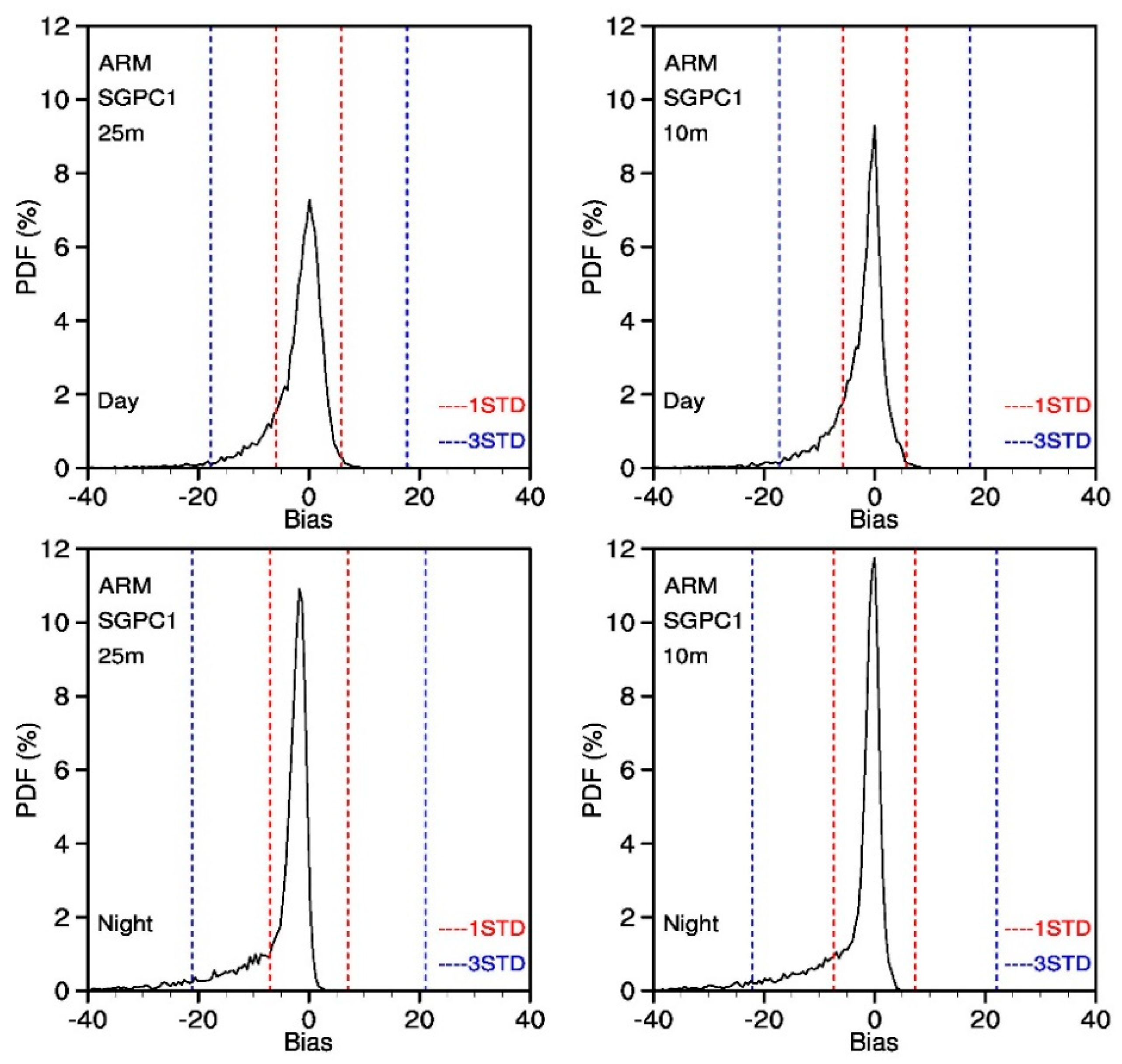
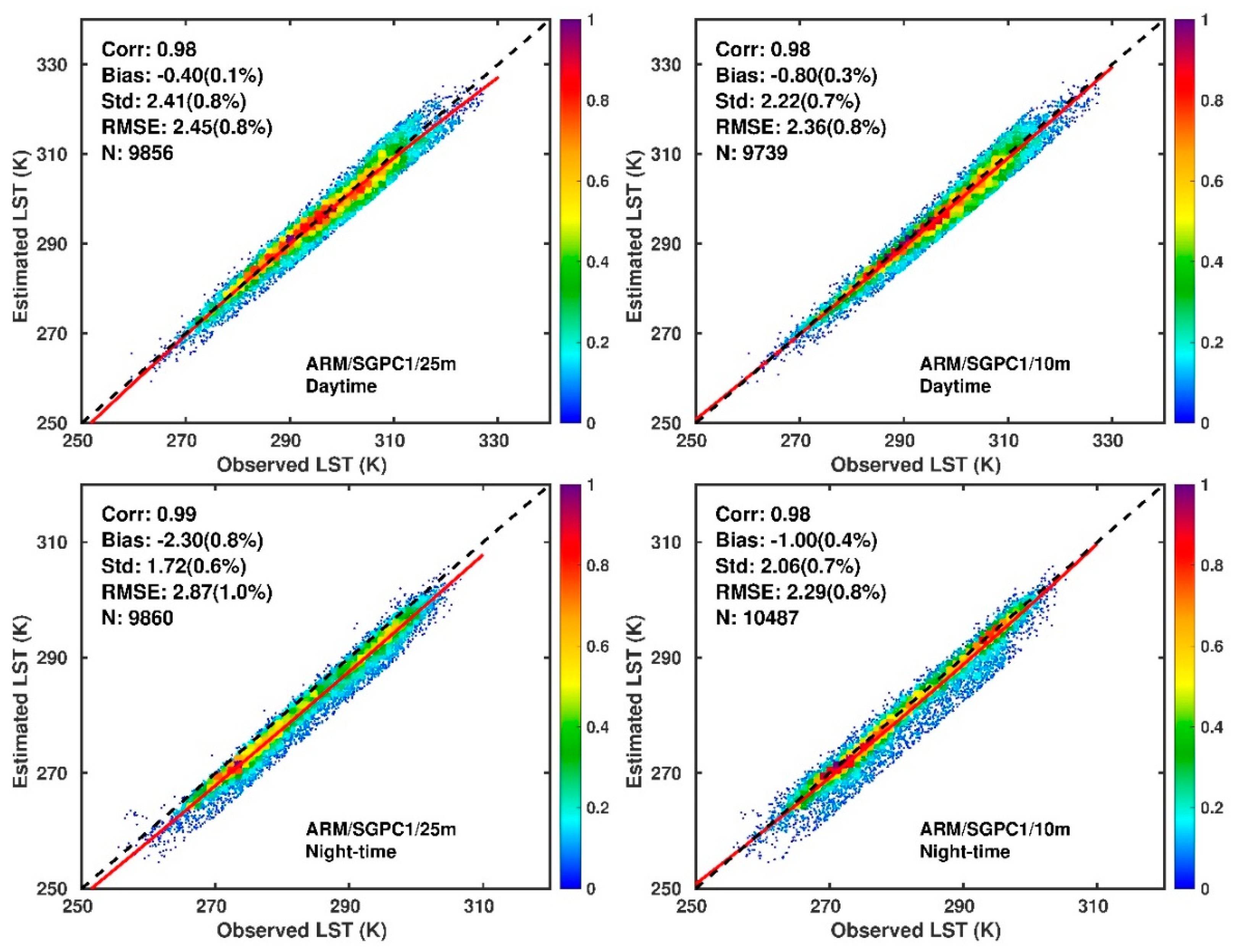
4.3. Evaluation against ARM SGP Site at Instantaneous Time Scale
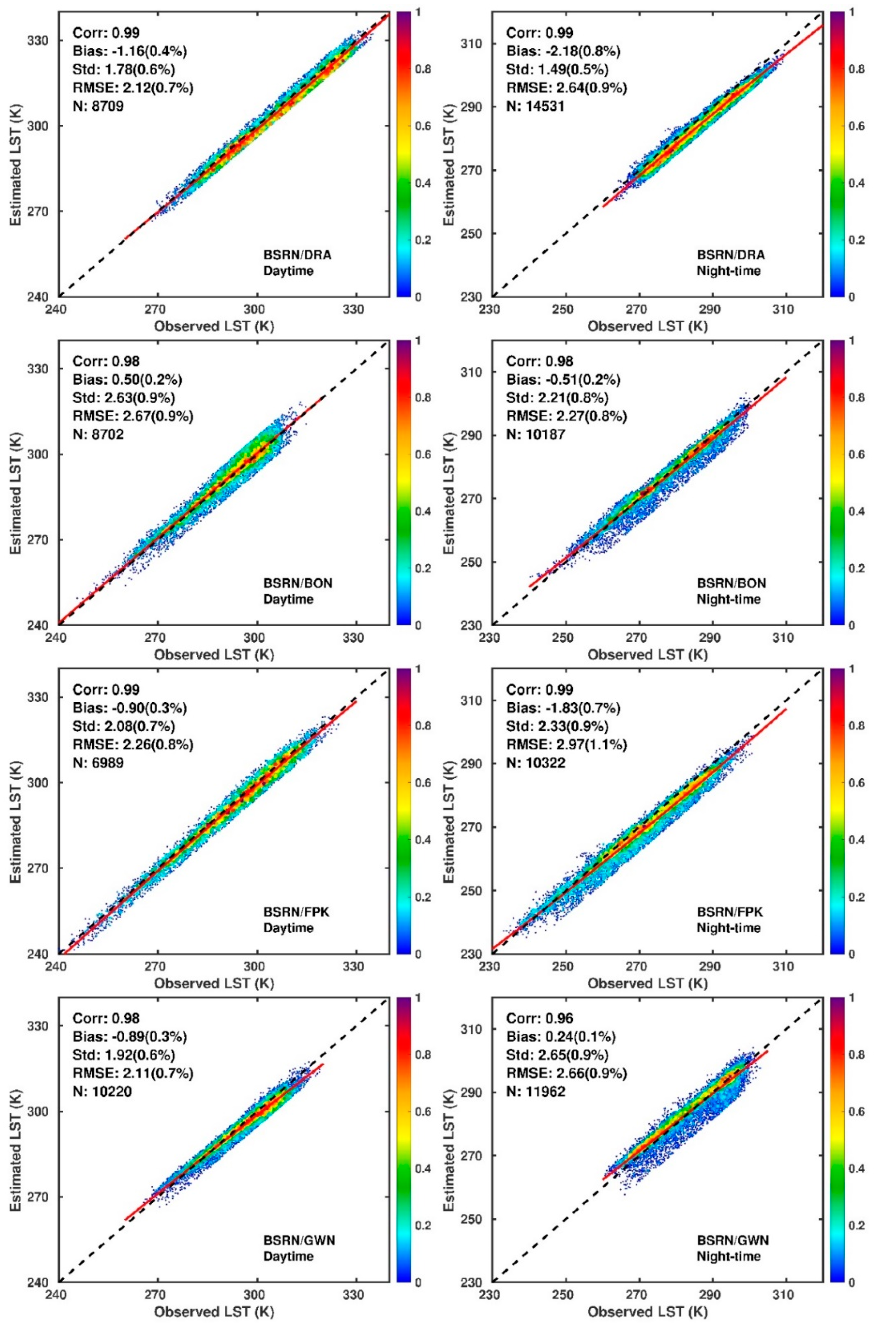
4.4. Evaluation against SURFRAD/BSRN
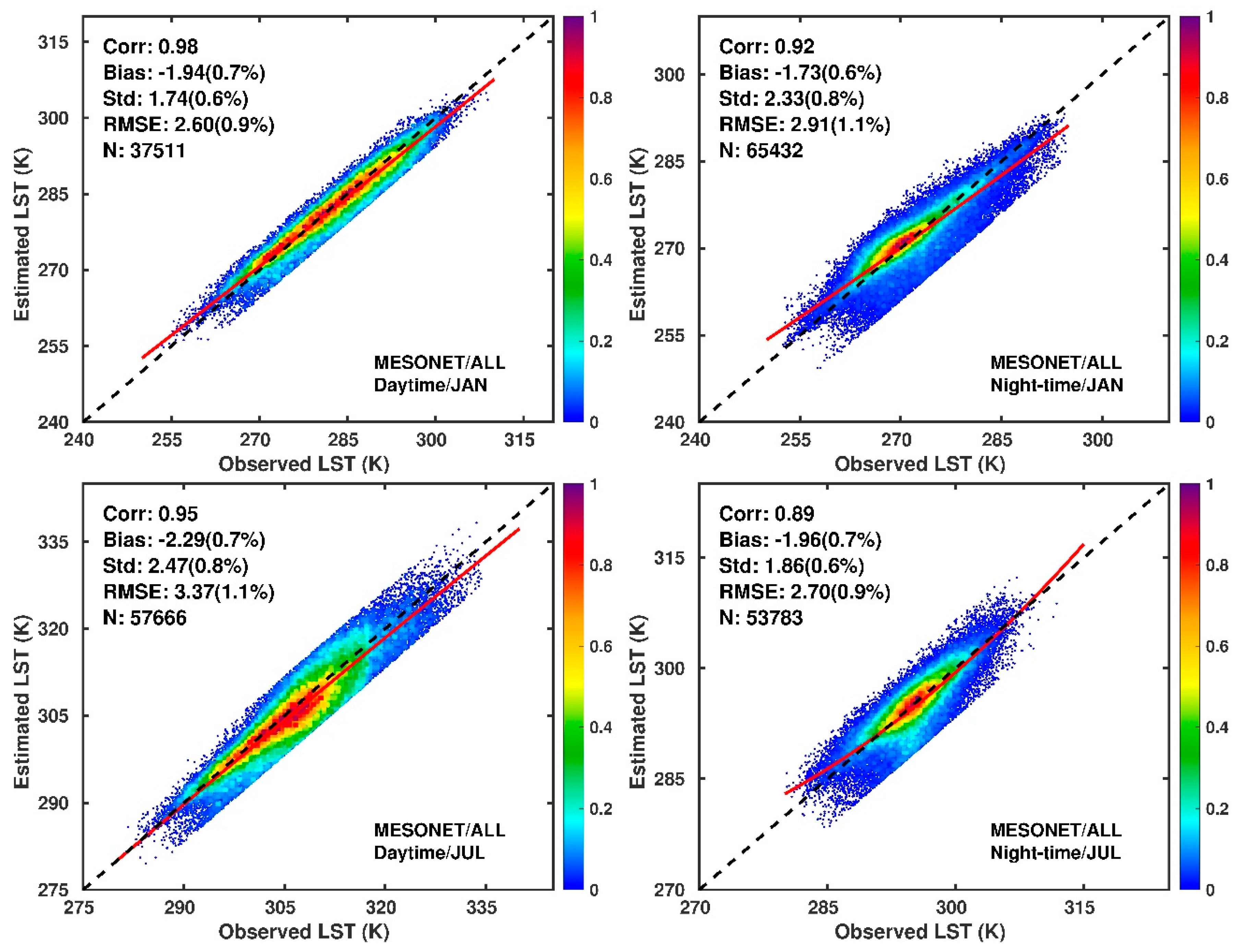
4.5. Evaluation against the Oklahoma MESONET Sites
4.6. Applications
- Seasonal distribution of LST at monthly scale
- A six-year climatology of LST over the US
5. Discussion
6. Summary
Author Contributions
Funding
Acknowledgments
Conflicts of Interest
References
- Trenberth, K.E.; Stepaniak, D.P.; Caron, J.M. Accuracy of atmospheric energy budgets from analyses. J. Clim. 2002, 15, 3343–3360. [Google Scholar] [CrossRef]
- Garand, L.; Buehner, M.; Wagneur, N. Background Error Correlation between Surface Skin and Air Temperatures: Estimation and Impact on the Assimilation of Infrared Window Radiances. J. Appl. Met. 2004, 43, 1853–1863. [Google Scholar] [CrossRef]
- Price, J.C. Estimation of surface temperatures from satellite thermal infrared data—A simple formulation for the atmospheric effect. Remote Sens. Environ. 1983, 13, 353–361. [Google Scholar] [CrossRef]
- Becker, F.; Li, Z.L. Toward a local split window method over land surface. Int. J. Remote Sens. 1990, 11, 369–393. [Google Scholar] [CrossRef]
- Wan, Z.M.; Dozier, J. A generalized split-window algorithm for retrieving land-surface temperature from space. IEEE Trans. Geosci. Remote Sens. 1996, 34, 892–905. [Google Scholar]
- Sun, D.; Pinker, R.T. Estimation of land surface temperature from a Geostationary Operational Environmental Satellite (GOES-8). J. Geophys. Res. 2003, 108, 4326. [Google Scholar] [CrossRef]
- Sobrino, J.A.; Li, Z.L.; Stoll, M.P.; Becker, F. Improvements in the split window technique for land surface temperature determination. IEEE Trans. Geosci. Remote Sens. 1994, 32, 243–253. [Google Scholar] [CrossRef]
- Nerry, F.; Labed, J.; Stoll, M.P. Spectral properties of land surfaces in the thermal infrared: 1. Laboratory measurements of absolute spectral emissivity signatures. J. Geophys. Res. 1990, 95, 7027–7044. [Google Scholar] [CrossRef]
- Hulley, G.C.; Hughes, C.G.; Hook, S.J. Quantifying uncertainties in land surface temperature and emissivity retrievals from ASTER and MODIS thermal infrared data. J. Geophys. Res. 2012, 117, D23113. [Google Scholar] [CrossRef]
- Lorenz, D. The effect of the long-wave reflectivity of natural surfaces on surface temperature measurements using radiometers. J. Appl. Meteorol. 1986, 5, 421–430. [Google Scholar] [CrossRef]
- Li, Z.-L.; Tang, B.-H.; Wu, H.; Ren, H.; Yan, G.; Wan, Z.; Trigo, I.F.; Sobrino, J.A. Satellite-derived land surface temperature: Current status and perspectives. Remote Sens. Environ. 2013, 131, 14–37. [Google Scholar] [CrossRef]
- Prabhakara, C.; Dalu, G.; Kunde, V.G. Estimation of sea surface temperature from remote sensing in the 11- and 13-µm window region. J. Geophys. Res. 1974, 79, 5039–5044. [Google Scholar] [CrossRef]
- McClain, E.P.; Pichel, W.G.; Walton, C.C.; Ahmad, Z.; Sutton, J. Multichannel improvements to satellite-derived global sea surface temperatures. Adv. Space Res. 1983, 2, 43–47. [Google Scholar] [CrossRef]
- Becker, F.; Li, Z.-L. Surface temperature and emissivity at various scales: Definition, measurement and related problems. Remote Sens. Rev. 1995, 12, 225–253. [Google Scholar] [CrossRef]
- McMillin, L.M. Estimation of sea surface temperatures from two infrared window measurements with different absorption. J. Geophys. Res. 1975, 80, 5113–5117. [Google Scholar] [CrossRef]
- Prata, A.J. Land surface temperatures derived from the advanced very high resolution radiometer and the along-track scanning radiometer: 2. Experimental results and validation of AVHRR algorithms. J. Geophys. Res. 1994, 99, 13025–13058. [Google Scholar] [CrossRef]
- François, C.; Ottlé, C. Atmospheric corrections in the thermal infrared: Global and water vapor dependent split-window algorithms-applications to ATSR and AVHRR data. IEEE Trans. Geosci. Remote Sens. 1996, 34, 457–470. [Google Scholar] [CrossRef]
- Coll, C.; Caselles, V.; Galve, J.M.; Valor, E.; Niclòs, R.; Sanchez, J.M. Ground measurements for the validation of land surface temperatures derived from AATSR and MODIS data. Remote Sens. Environ. 2005, 97, 288–300. [Google Scholar] [CrossRef]
- Trigo, I.F.; Monteiro, I.T.; Olesen, F.; Kabsch, E. An assessment of remotely sensed land surface temperature. J. Geophys. Res. 2008, 113, D17108. [Google Scholar] [CrossRef]
- Wan, Z. New refinements and validation of the collection-6 MODIS land-surface temperature/emissivity product. Remote Sens. Environ. 2014, 140, 36–45. [Google Scholar] [CrossRef]
- Van de Griend, A.A.; Owe, M. On the relationship between thermal emissivity and the normalized difference vegetation index for natural surfaces. Int. J. Remote Sens. 1993, 14, 1119–1131. [Google Scholar] [CrossRef]
- Valor, E.; Caselles, V. Mapping land surface emissivity from NDVI: Application to European, African, and South American areas. Remote Sens. Environ. 1996, 57, 167–184. [Google Scholar] [CrossRef]
- Karnieli, A.; Agam, N.; Pinker, R.T.; Anderson, M.; Imhoff, M.I.; Gutman, G.G.; Panov, N.; Goldberg, A. Use of NDVI and LST for Assessing Vegetation Health: Merits and Limitations. J. Clim. 2010, 23, 618–633. [Google Scholar] [CrossRef]
- Kealy, P.S.; Hook, S.J. Separating temperature and emissivity in thermal infrared multispectral scanner data: Implications for recovering land surface temperatures. IEEE Trans. Geosci. Remote Sens. 1993, 31, 1155–1164. [Google Scholar] [CrossRef]
- Gillespie, A.; Rokugawa, S.; Matsunaga, T.; Cothern, J.S.; Hook, S.; Kahle, A.B. A temperature and emissivity separation algorithm for Advanced Spaceborne Thermal Emission and Reflection Radiometer (ASTER) images. IEEE Trans. Geosci. Remote Sens. 1998, 36, 1113–1126. [Google Scholar] [CrossRef]
- Wan, Z.; Li, Z.-L. A physics-based algorithm for retrieving land-surface emissivity and temperature from EOS/MODIS data. IEEE Trans. Geosci. Remote Sens. 1997, 35, 980–996. [Google Scholar]
- Liang, S. An optimization algorithm for separating land surface temperature and emissivity from multispectral thermal infrared imagery. IEEE Trans. Geosci. Remote Sens. 2001, 39, 264–274. [Google Scholar] [CrossRef]
- Schmugge, T.; French, A.; Ritchie, J.C.; Rango, A.; Pelgrum, H. Temperature and emissivity separation from multispectral data. Remote Sens. Environ. 2001, 78, 189–198. [Google Scholar]
- Ma, X.L.; Wan, Z.; Moeller, C.C.; Menzel, W.P.; Gumley, L.E. Simultaneous retrieval of atmospheric profiles, land-surface temperature, and surface emissivity from Moderate-Resolution Imaging Spectroradiometer thermal infrared data: Extension of a two-step physical algorithm. Appl. Opt. 2002, 41, 909–924. [Google Scholar] [CrossRef] [PubMed]
- Borbas, E.; Hulley, G.; Feltz, M.; Knuteson, R.; Hook, S. The Combined ASTER MODIS Emissivity over Land (CAMEL) Part 1: Methodology and High Spectral Resolution Application. Remote Sens. 2018, 10, 643. [Google Scholar] [CrossRef]
- Feltz, M.; Borbas, E.; Knuteson, R.; Hulley, G.; Hook, S. The Combined ASTER MODIS Emissivity over Land (CAMEL) Part 2: Uncertainty and Validation. Remote Sens. 2018, 10, 664. [Google Scholar] [CrossRef]
- Sun, D.; Pinker, R.T. Implementation of GOES-based land surface temperature diurnal cycle to AVHRR. Int. J. Remote Sens. 2005, 26, 3975–3984. [Google Scholar] [CrossRef]
- Inamdar, A.K.; French, A.; Hook, S.; Vaughan, G.; Luckett, W. Land surface temperature retrieval at high spatial and temporal resolutions over the southwestern United States. J. Geophys. Res. 2008, 113, D07107. [Google Scholar] [CrossRef]
- Heidinger, A.K.; Evan, A.T.; Foster, M.J.; Walther, A. A naive Bayesian cloud detection scheme derived from CALIPSO and applied with PATMOS-x. J. Appl. Meteorol. Climatol. 2012, 51, 1129–1144. [Google Scholar] [CrossRef]
- Scarino, B.R.; Minnis, P.; Chee, T.; Bedka, K.M.; Yost, C.R.; Palikonda, R. Global clear-sky surface skin temperature from multiple satellites using a single-channel algorithm with angular anisotropy corrections. Atmos. Meas. Tech. 2017, 10, 351–371. [Google Scholar] [CrossRef]
- Gunshor, M.M.; Schmit, T.J.; Menzel, W.P.; Tobin, D.C. Intercalibration of broadband geostationary imagers using AIRS. J. Atmos. Ocean. Technol. 2009, 26, 746–758. [Google Scholar] [CrossRef]
- Weinreb, M.P.; Jamieson, M.; Fulton, N.; Chen, Y.; Johnson, J.X.; Bremer, J.; Smith, C.; Baucom, J. Operational calibration of geostationary operational environmental Satellite-8 and-9 imagers and sounders. Appl. Opt. 2007, 36, 6895–6904. [Google Scholar] [CrossRef]
- Gelaro, R.; McCarty, W.; Suárez, M.J.; Todling, R.; Molod, A.; Takacs, L.; Randles, C.A.; Darmenov, A.; Bosilovich, M.G.; Reichle, R.; et al. The Modern-Era Retrospective Analysis for Research and Applications, Version 2 (MERRA-2). J. Clim. 2017, 30, 5419–5454. [Google Scholar] [CrossRef]
- Wan, Z. MODIS Land Surface Temperature Products Users’ Guide; Collection-6, ERI; University of California: Santa Barbara, CA, USA, 2013. [Google Scholar] [CrossRef]
- Hicks, B.B.; DeLuisi, J.J.; Matt, D.R. The NOAA Integrated Surface Irradiance Study (ISIS)—A new surface radiation monitoring program. Bull. Am. Meteorol. Soc. 1996, 77, 2857–2864. [Google Scholar] [CrossRef]
- Ohmura, A.; Dutton, E.G.; Forgan, B.; Fröhlich, C.; Gilgen, H.; Hegner, H.; Heimo, A.; König-Langlo, G.; McArthur, B.; Müller, G.; et al. Baseline Surface Radiation Network (BSRN/WCRP): New precision radiometry for climate research. Bull. Am. Meteorol. Soc. 1998, 79, 2115–2136. [Google Scholar] [CrossRef]
- Augustine, J.A.; Hodges, G.B.; Cornwall, C.R.; Michalsky, J.J.; Medina, C.I. An update on SURFRAD: The GCOS surface radiation budget network for the continental United States. J. Atmos. Ocean. Technol. 2005, 22, 1460–1472. [Google Scholar] [CrossRef]
- Guillevic, P.; Göttsche, F.; Nickeson, J.; Hulley, G.; Ghent, D.; Yu, Y.; Trigo, I.; Hook, S.; Sobrino, J.A.; Remedios, J.; et al. Land Surface Temperature Product Validation Best Practice Protocol, Version 1.0. In Best Practice for Satellite-Derived Land Product Validation (p. 60): Land Product Validation Subgroup (WGCV/CEOS); Guillevic, P., Göttsche, F., Nickeson, J., Román, M., Eds.; Internal Publication: Brussels, Belgium, 2017. [Google Scholar] [CrossRef]
- McPherson, R.A.; Fiebrich, C.A.; Crawford, K.C.; Kilby, J.R.; Grimsley, D.L.; Martinez, J.E.; Basara, J.B.; Illston, B.G.; Morris, D.A.; Kloesel, K.A.; et al. Statewide monitoring of the mesoscale environment: A technical update on the Oklahoma Mesonet. J. Atmos. Ocean. Technol. 2007, 24, 301–321. [Google Scholar] [CrossRef]
- Fiebrich, C.A.; Martinez, J.E.; Brotzge, J.A.; Basara, J.B. The Oklahoma Mesonet’s skin temperature network. J. Atmos. Ocean. Technol. 2003, 20, 1496–1504. [Google Scholar] [CrossRef]
- Fuchs, M. Infrared measurement of canopy temperature and detection of plant water stress. Theor. Appl. Climatol. 1990, 42, 253–261. [Google Scholar] [CrossRef]
- Sobrino, J.A.; Skokovic, D. Permanent Stations for Calibration/Validation of Thermal Sensors over Spain. Data 2016, 1, 10. [Google Scholar] [CrossRef]
- Hansen, M.C.; Defries, R.S.; Townshend, J.R.G.; Sohlberg, R. Global land cover classification at 1 km resolution using a classification tree approach. Int. J. Remote Sens. 1998, 21, 1331–1364. [Google Scholar] [CrossRef]
- Li, X.; Pinker, R.T.; Wonsick, M.M.; Ma, Y. Toward improved satellite estimates of short-wave radiative fluxes-Focus on cloud detection over snow: 1. Methodology. J. Geophys. Res. 2007, 112, D07208. [Google Scholar] [CrossRef]
- Pinker, R.T.; Li, X.; Meng, W.; Yegorova, E.A. Toward improved satellite estimates of short-wave radiative fluxes-Focus on cloud detection over snow: 2. Results. J. Geophys. Res. 2007, 112, D09204. [Google Scholar] [CrossRef]
- Wang, H.; Pinker, R.T.; Minnis, P.; Khaiyer, M.M. Experiments with Cloud Properties: Impact on Surface Radiative Fluxes. J. Atmos. Ocean. Technol. 2008, 25, 1034–1040. [Google Scholar] [CrossRef]
- Miller, S.D. Physical decoupling of the GOES daytime 3.9 µm channel thermal emission and solar reflection components using total solar eclipse data. Int. J. Remote Sens. 2001, 22, 9–34. [Google Scholar] [CrossRef]
- Eyre, J.R. A Fast Radiative Transfer Model. for Satellite Sounding System; ECMWF Research Department Technical Memorandum 176; European Centre for Medium-Range Weather Forecasts: Reading, UK, 1991. [Google Scholar]
- Saunders, R.W.; Matricardi, M.; Brunel, P. An Improved Fast Radiative Transfer Model for Assimilation of Satellite Radiance Observations. QJRMS 1991, 125, 1407–1425. [Google Scholar] [CrossRef]
- Matricardi, M.; Saunders, R. Fast radiative transfer model for simulation of infrared atmospheric sounding interferometer radiances. Appl. Opt. 1999, 38, 5679–5691. [Google Scholar] [CrossRef] [PubMed]
- Hulley, G.; Freepartner, R.; Malakar, N.; Sarkar, S. Moderate Resolution Imaging Spectroradiometer (MODIS) Land Surface Temperature and Emissivity Product (MOD21) Users’ Guide; Collection-6; Jet Propulsion Laboratory California Institute of Technology: Pasadena, CA, USA, 2016. [Google Scholar]
- Göttsche, F.; Olesen, F.S.; Høyer, J.L.; Wimmer, W.; Nightingale, T. Fiducial Reference Measurements for Validation of Surface Temperature from Satellites (FRM4STS); Technical Report 3—A Framework to Verify the Field Performance of TIR FRM; ESA Contract No. 4000113848_15I-LG; Internal Publication: Brussels, Belgium, 2017; pp. 1–75. [Google Scholar]
- Hulley, G.C.; Hook, S.J. Generating Consistent Land Surface Temperature and Emissivity Products between ASTER and MODIS Data for Earth Science Research. IEEE Trans. Geosci. Remote Sens. 2011, 49, 1304–1315. [Google Scholar] [CrossRef]
- Yu, Y.; Privette, J.P.; Pinheiro, A.C. Evaluation of split-window land surface temperature algorithms for generating climate data records. IEEE Trans. Geosci. Remote Sens. 2008, 46, 179–192. [Google Scholar] [CrossRef]
- Snyder, W.; Wan, Z.; Zhang, Y.; Feng, Y. Classification based emissivity for land surface temperature measurement from space. Int. J. Remote Sens. 1998, 19, 2753–2774. [Google Scholar] [CrossRef]
- Zhang, D.; Tang, R.; Zhao, W.; Tang, B.; Wu, H.; Shao, K.; Li, Z.-L. Surface Soil Water Content Estimation from Thermal Remote Sensing based on the Temporal Variation of Land Surface Temperature. Remote Sens. 2014, 6, 3170–3187. [Google Scholar] [CrossRef]
- Dai, A.; Trenberth, K.E. The diurnal cycle and its depiction in the Community Climate System Model. J. Clim. 2004, 17, 930–951. [Google Scholar] [CrossRef]
- Aires, F.; Prigent, C.; Rossow, W.B. Temporal interpolation of global surface skin temperature diurnal cycle over land under clear and cloudy conditions. J. Geophys. Res. 2004, 109, D04313. [Google Scholar] [CrossRef]
- Duan, S.-B.; Li, Z.-L.; Tang, B.-H.; Wu, H.; Tang, R.; Bi, Y.; Zhou, G. Estimation of Diurnal Cycle of Land Surface Temperature at High Temporal and Spatial Resolution from Clear-Sky MODIS Data. Remote Sens. 2014, 6, 3247–3262. [Google Scholar] [CrossRef]
- Ignatov, A.; Gutman, G. Monthly mean diurnal cycles in surface temperature over and land for global climate studies. J. Clim. 1999, 12, 1900–1910. [Google Scholar] [CrossRef]
- Rossow, W.B.; Schiffer, R.A. ISCCP Cloud Data Products. Bull. Am. Meteorol. Soc. 1991, 72, 2–20. [Google Scholar] [CrossRef]
- Randles, C.A.; Kinne, S.; Myhre, G.; Schulz, M.; Stier, P.; Fischer, J.; Doppler, L.; Highwood, E.; Ryder, C.; Harris, B.; et al. Intercomparison of shortwave radiative transfer schemes in global aerosol modeling: Results from the AeroCom Radiative Transfer Experiment. Atmos. Chem. Phys. 2013, 13, 2347–2379. [Google Scholar] [CrossRef]
- Ermida, S.L.; Trigo, I.S.; DaCamara, C.C.; Jiménez, C.; Prigent, C. Quantifying the Clear-Sky Bias of Satellite Land SurfaceTemperature Using Microwave-Based Estimates. J. Geophys. Res. 2019, 124, 844–857. [Google Scholar] [CrossRef]
- Pinheiro, A.C.T.; Jeffrey, L. Privette, and Pierre Guillevic, Modeling the Observed Angular Anisotropy of Land Surface Temperature in a Savanna. IEEE Trans. Geosci. Remote Sens. 2006, 44, 1036–1047. [Google Scholar] [CrossRef]
- Ermida, S.L.; Trigo, I.S.; DaCamara, C.C.; Pires, A.C. A Methodology to Simulate LST Directional Effects Based on Parametric Models and Landscape Properties. Remote Sens. 2018, 10, 1114. [Google Scholar] [CrossRef]


| Satellite | Channel | Symbol | Wavelength | Objective | Spatial Resolution (Nadir) |
|---|---|---|---|---|---|
| GOES-8 & GOES12 | 1 | R1 | 0.67 μm | Cloud | 1 km × 1 km |
| 2 | R2 and T2 | 3.9 μm | Cloud and snow | 4 km × 4 km | |
| 3 | T3 | 6.7 μm | Water vapor | 4 km × 4 km | |
| 4 | T4 | 10.7 μm | Surface temperature | 4 km × 4 km | |
| GOES-8 | 5 | T5 | 12.0 μm | Sea surface temperature and water vapor | 4 km × 4 km |
| GOES12 | 6 | T6 | 13.3 μm | …… | 4 km × 4 km |
| Test | Apply | Cloud Detection Variable | Cloud That May Be Detected |
|---|---|---|---|
| RGCT | Day | R1 | Highly-reflective cloud |
| TGCT | Day and Night | T4 | Cold cloud |
| C2AT | Day | R2 | Weakly Reflective Cloud |
| TMFT | Day and Night | T2 − T4 | Water cloud + Cirrus + Other Clouds |
| FMFT | Day and Night | T4 − T5 | Thin Cirrus |
| ULST | Night | T2 − T4 | Nighttime uniform low stratus |
| CIRT | Night | (T2 − T4)/T4 | Nighttime cirrus |
| Corr | Mean Bias | Std | RMS | No. Cases | ||||||
|---|---|---|---|---|---|---|---|---|---|---|
| Day | Night | Day | Night | Day | Night | Day | Night | Day | Night | |
| 25 m | 0.89 | 0.81 | −2.09 | −5.12 | 5.92 | 7.04 | 6.28 | 8.7 | 11,781 | 12,335 |
| 10 m | 0.89 | 0.80 | −2.68 | −3.64 | 5.75 | 7.37 | 6.34 | 8.22 | 11,940 | 12,639 |
© 2019 by the authors. Licensee MDPI, Basel, Switzerland. This article is an open access article distributed under the terms and conditions of the Creative Commons Attribution (CC BY) license (http://creativecommons.org/licenses/by/4.0/).
Share and Cite
Pinker, R.T.; Ma, Y.; Chen, W.; Hulley, G.; Borbas, E.; Islam, T.; Hain, C.; Cawse-Nicholson, K.; Hook, S.; Basara, J. Towards a Unified and Coherent Land Surface Temperature Earth System Data Record from Geostationary Satellites. Remote Sens. 2019, 11, 1399. https://doi.org/10.3390/rs11121399
Pinker RT, Ma Y, Chen W, Hulley G, Borbas E, Islam T, Hain C, Cawse-Nicholson K, Hook S, Basara J. Towards a Unified and Coherent Land Surface Temperature Earth System Data Record from Geostationary Satellites. Remote Sensing. 2019; 11(12):1399. https://doi.org/10.3390/rs11121399
Chicago/Turabian StylePinker, Rachel T., Yingtao Ma, Wen Chen, Glynn Hulley, Eva Borbas, Tanvir Islam, Chris Hain, Kerry Cawse-Nicholson, Simon Hook, and Jeff Basara. 2019. "Towards a Unified and Coherent Land Surface Temperature Earth System Data Record from Geostationary Satellites" Remote Sensing 11, no. 12: 1399. https://doi.org/10.3390/rs11121399
APA StylePinker, R. T., Ma, Y., Chen, W., Hulley, G., Borbas, E., Islam, T., Hain, C., Cawse-Nicholson, K., Hook, S., & Basara, J. (2019). Towards a Unified and Coherent Land Surface Temperature Earth System Data Record from Geostationary Satellites. Remote Sensing, 11(12), 1399. https://doi.org/10.3390/rs11121399


