Multi-Index Image Differencing Method (MINDED) for Flood Extent Estimations

 , , , and
Abstract
:
1. Introduction
1.1. Flood Extent Estimation Methods Based on Remote Sensing Imagery
1.1.1. Optical Water-Related Indices
1.1.2. Flood-Related Synthetic Aperture Radar Applications
2. Proposed Method
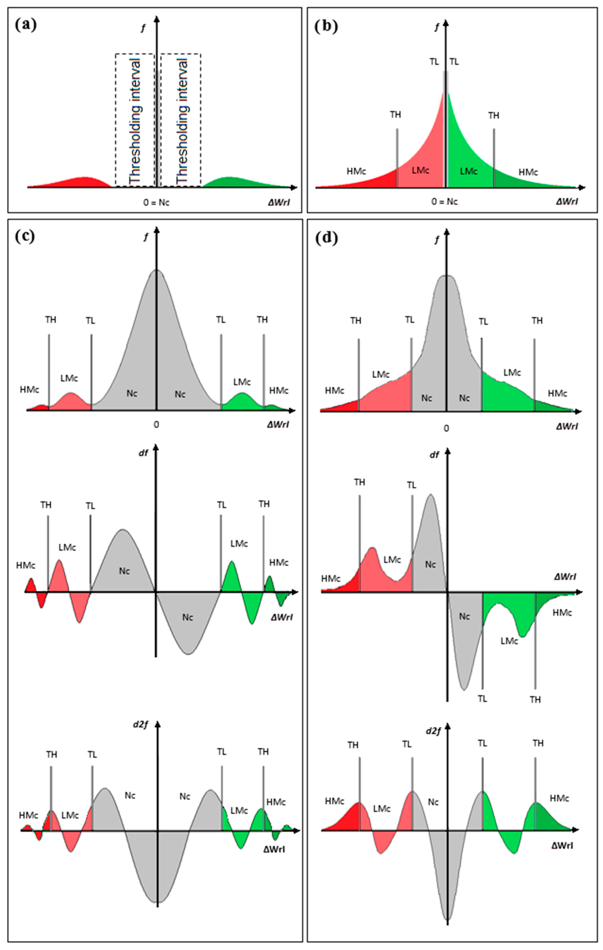
2.1. MINDED: the Multi-Index Differencing Approach
2.2. Pre-Processing Considerations
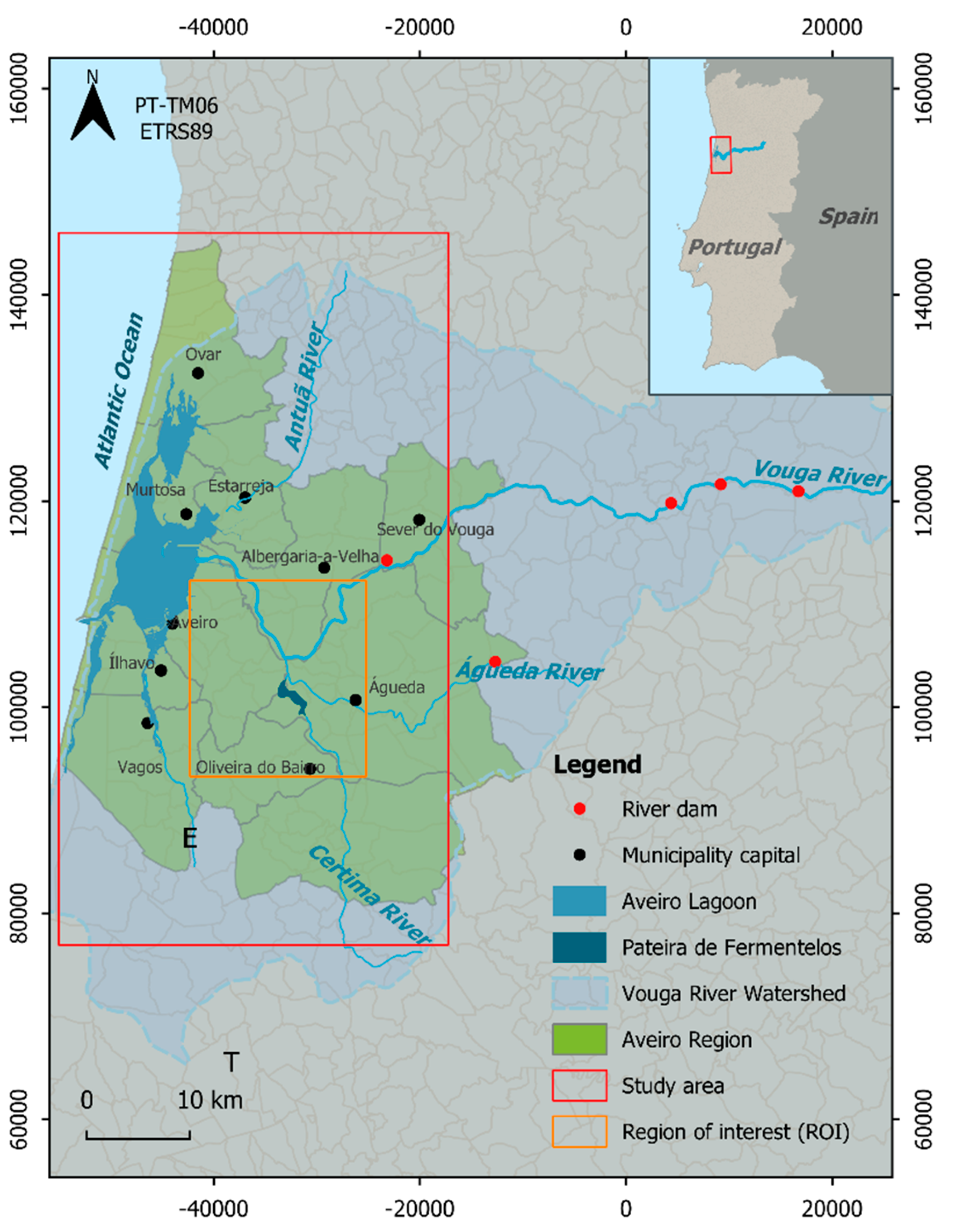
3. Study Area: The Aveiro Region (Portugal)
4. Results
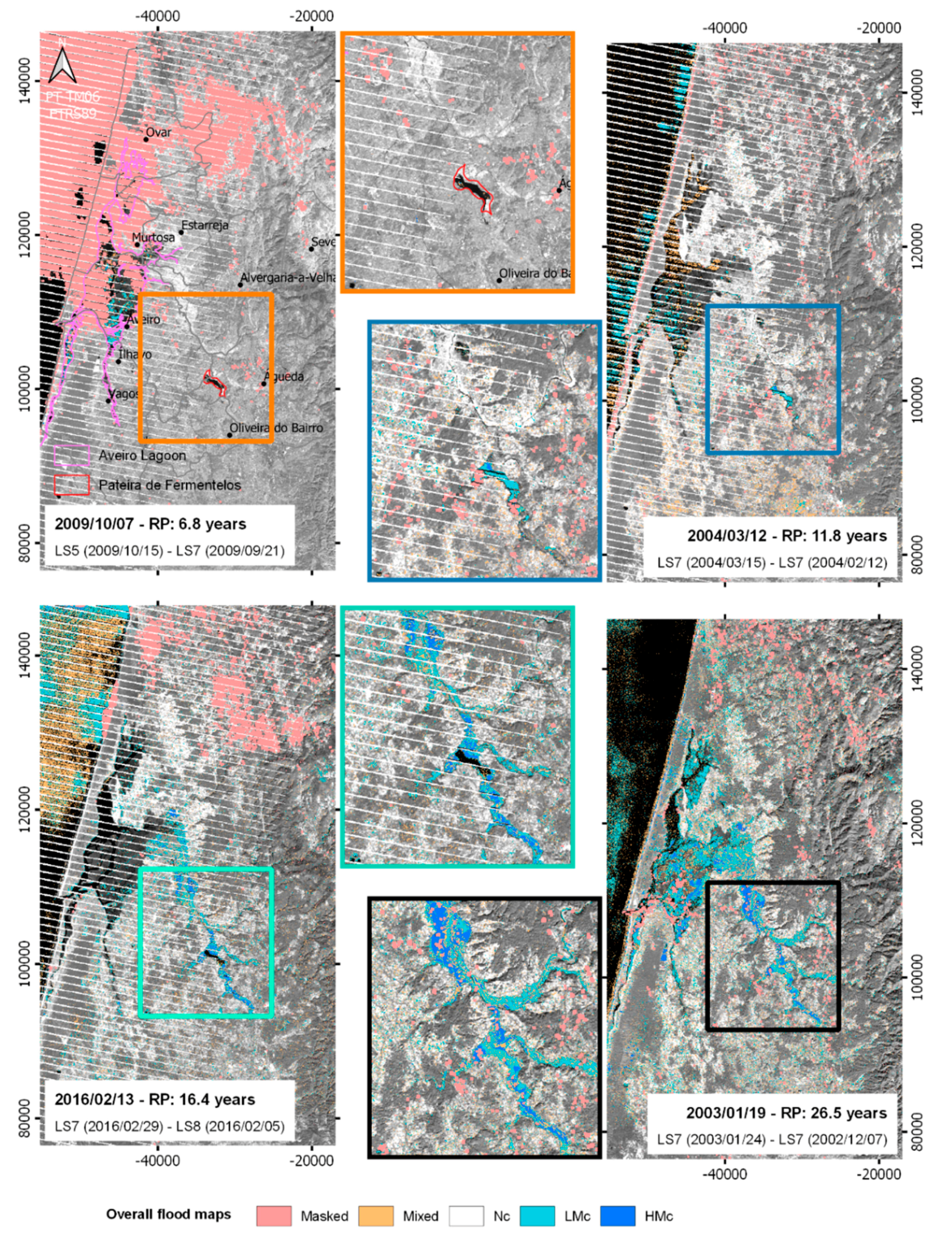
4.1. Selection of Events
4.2. Satellite Data Selection
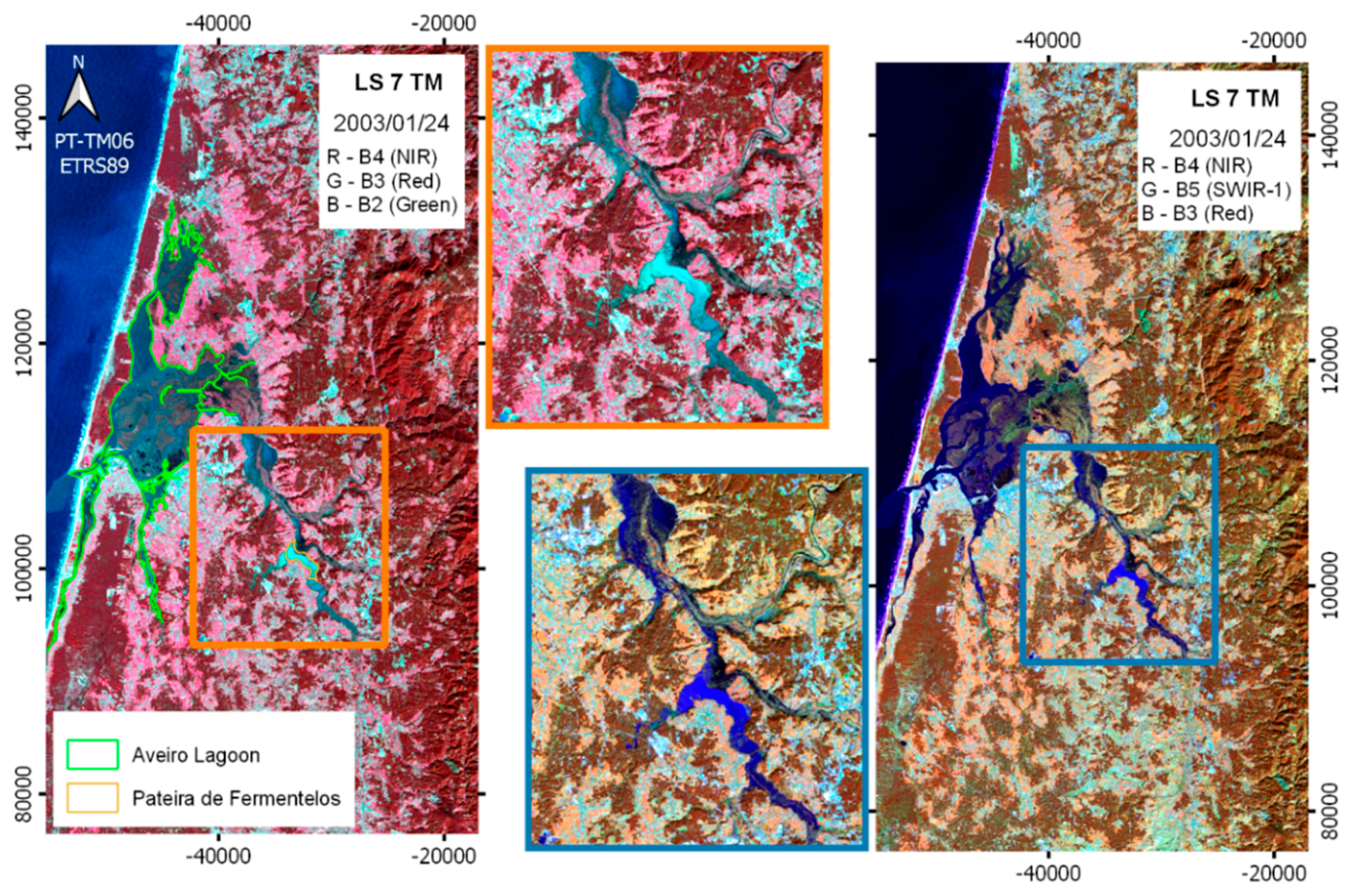
4.3. Pre-Processing
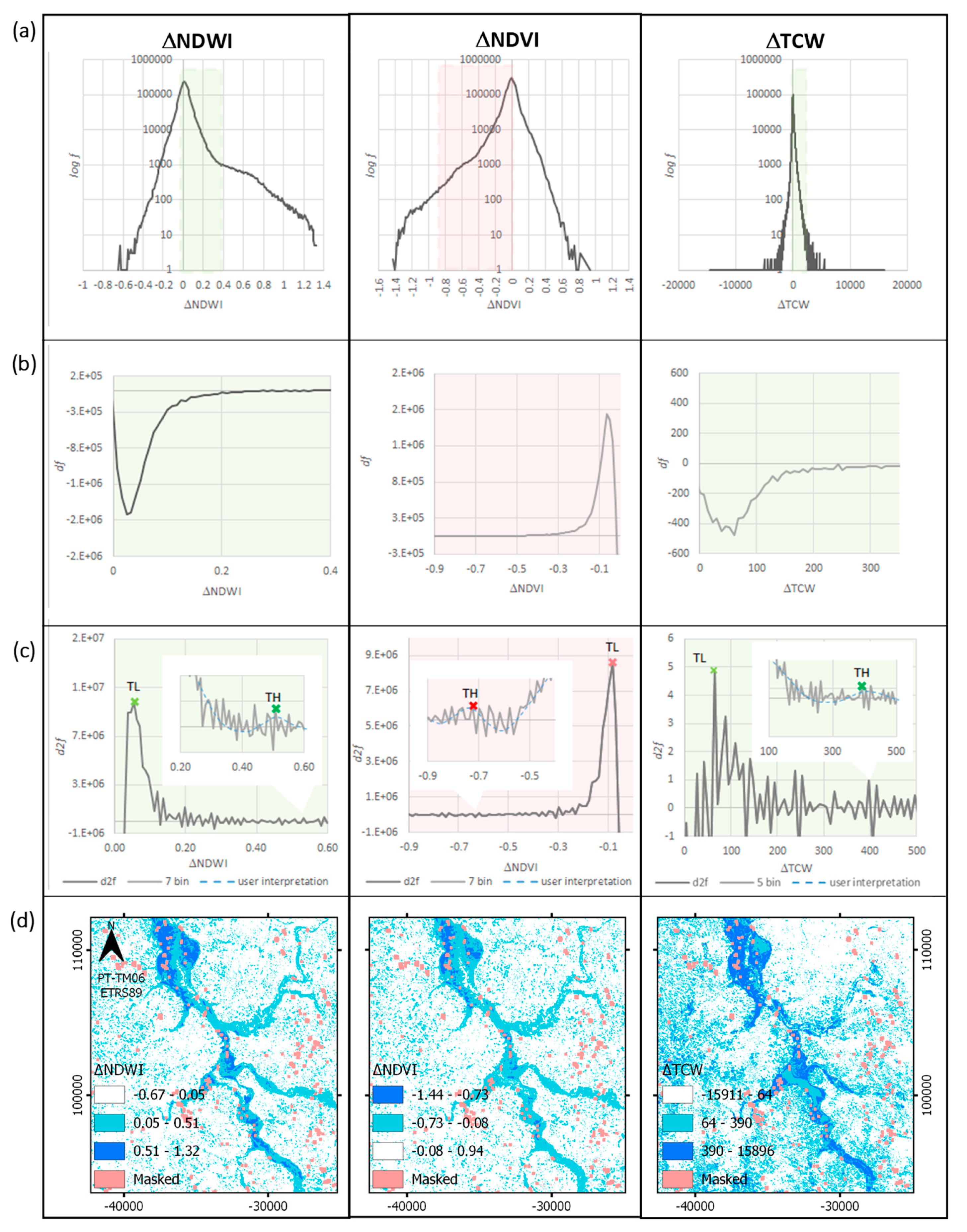
4.4. Index Calculation and Differencing
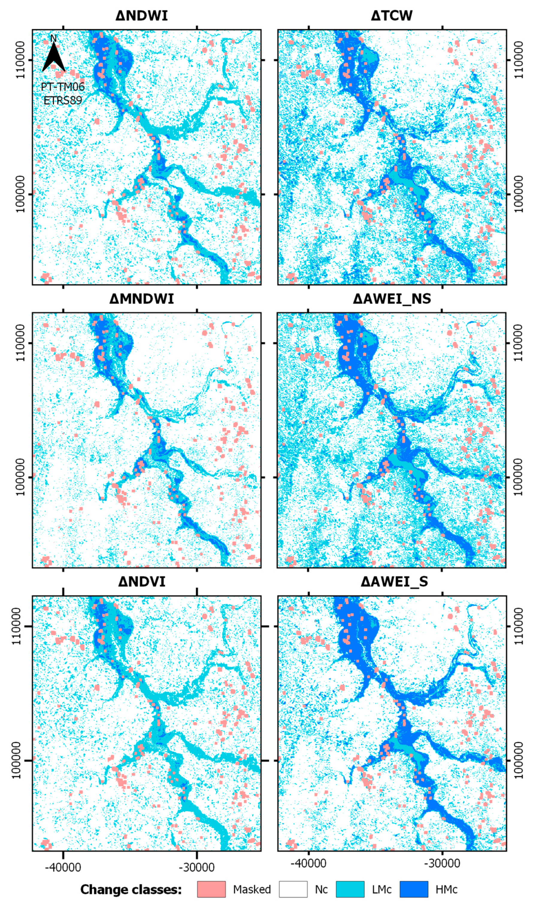
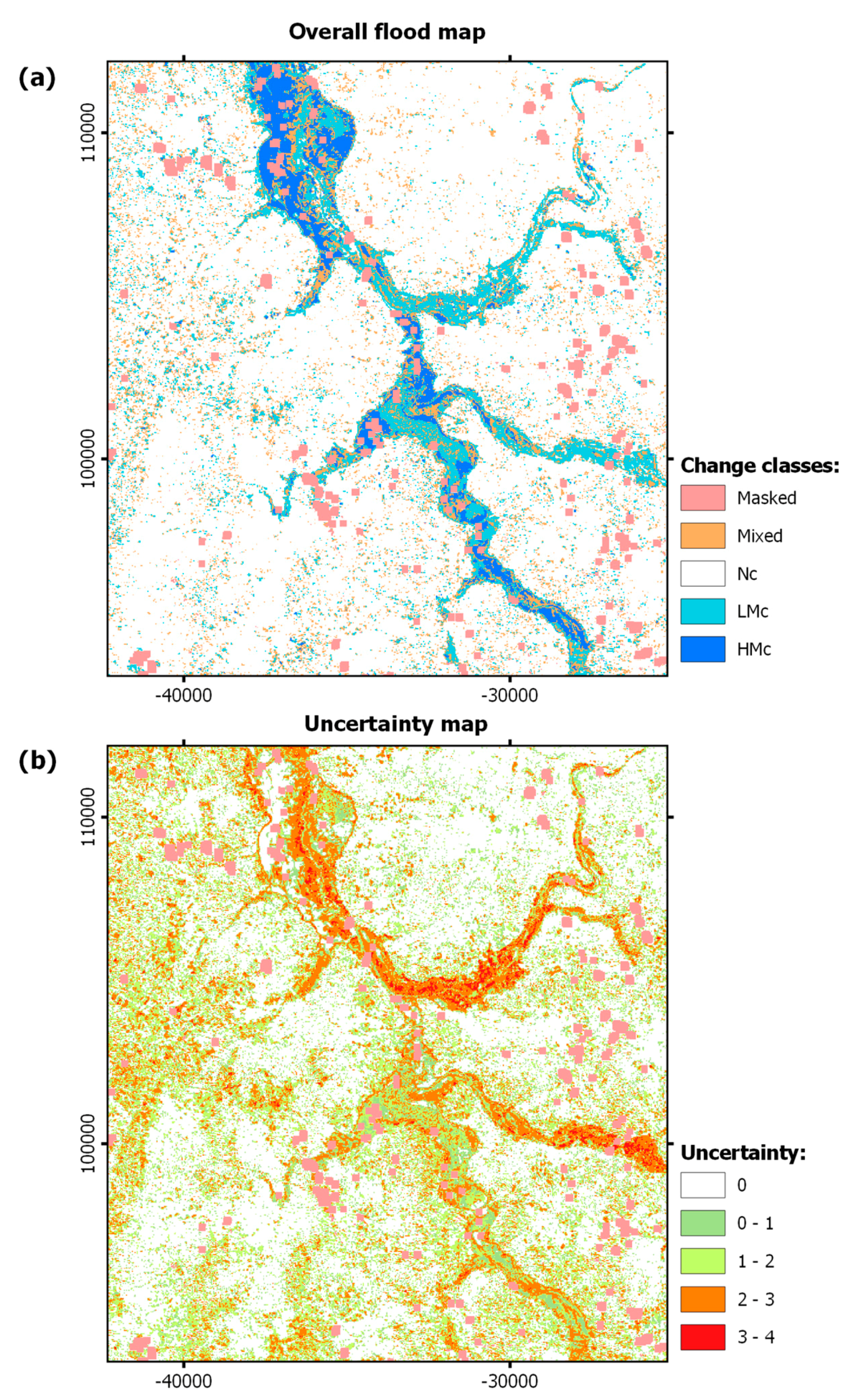
4.5. Flood Extent Estimation Results
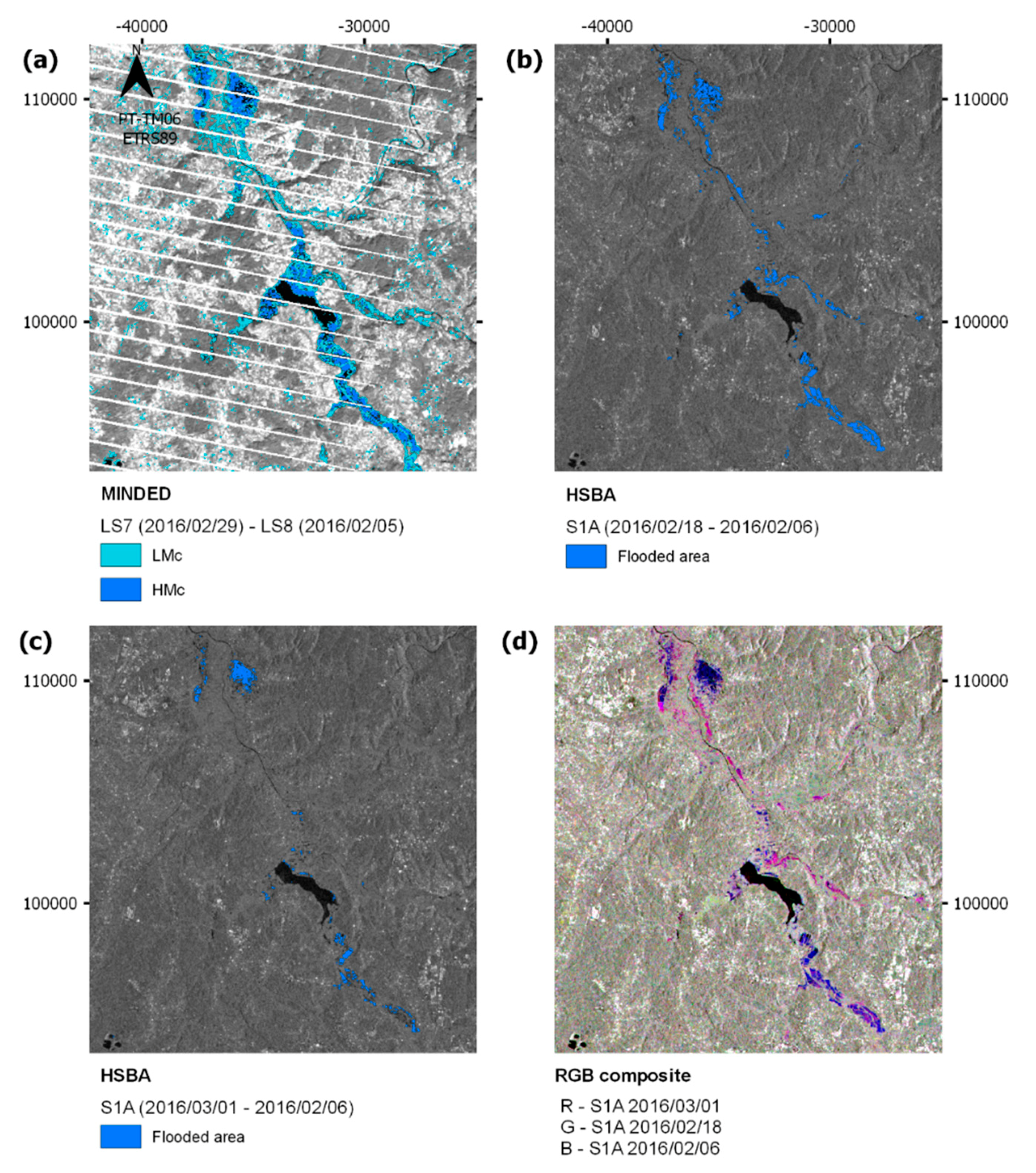
4.6. Comparison with SAR Data
5. Discussion
6. Conclusions
Author Contributions
Funding
Acknowledgments
Conflicts of Interest
Appendix A

| Date | Maximum Daily Precipitation (mm) | Maximum Return Period (Years) | Available Satellite Images | Flood Event Records [88,89] | |
|---|---|---|---|---|---|
| t1 | t2 | ||||
| 1995/12/25 | 180.0 | 32.7 | - | - | Águeda, Albergaria-a-Velha, Aveiro, Murtosa |
| 2007/06/14 | 85.0 | 29.3 | LS5 (2007/06/04) | LS5 (2007/06/20) * | Ovar |
| #2003/01/19 | 80.6 | 26.5 | LS7 (2002/12/07) | LS7 (2003/01/24) | Estarreja, Oliveira do Bairro, Vagos, Murtosa |
| 2008/04/10 | 96.1 | 24.9 | - | LS7 (2008/04/11 *) | Estarreja, Murtosa, Mira, Vagos, Olveira do Bairro |
| 1993/10/09 | 124.9 | 24.2 | - | - | - |
| 1995/12/26 | 114.5 | 23.6 | - | - | Águeda, Albergaria-a-Velha, Aveiro, Murtosa |
| 1983/11/22 | 97.0 | 23.4 | - | - | - |
| 1985/02/09 | 120.0 | 23.1 | - | - | - |
| 2004/12/01 | 90.0 | 22.9 | LS7 (2004/11/26) | LS7 (2004/12/12 *) | - |
| 1989/12/21 | 120.0 | 19.8 | - | - | - |
| 2001/01/27 | 150.1 | 19.6 | - | LS7 (2001/02/03) * | Albergaria-a-Velha, Aveiro, Estarreja, ílhavo, Sever do Vouga, Vagos, Mira, Murtosa |
| #2016/02/13 | 128.9 | 16.4 | S1 (2016/02/06); LS8 (2016/02/05) | LS7 (2016/02/29) | Águeda |
| 1984/10/19 | 121.0 | 16.4 | - | - | - |
| 1998/09/28 | 85.0 | 14.6 | - | - | Águeda, Vagos |
| 2003/01/03 | 98.8 | 12.4 | - | - | - |
| 2015/09/16 | 129.4 | 12.1 | LS7 (2015/09/06); LS8 (2015/09/14 *); S1A (2015/09/10, 2015/09/15) | LS7 (2015/09/22 *); LS8 (2015/09/30 *); S1 (2015/09/16) | - |
| #2004/03/12 | 78.5 | 11.8 | LS7 (2004/02/12) | LS7 (2004/03/15) | - |
| 1996/02/06 | 125.7 | 11.8 | - | - | Murtosa |
| 1980/11/12 | 85.5 | 11.5 | - | - | - |
| 2006/11/24 | 96.1 | 11.4 | - | - | Estarreja, Ílhavo |
| 2016/01/04 | 133.3 | 9.8 | LS7 (2015/12/27 *); S1 (2016/01/02); S2 (2015/12/22) | S1A (2016/01/08); S2 (2016/01/11 *) | Águeda |
| 1994/01/06 | 116.1 | 9.8 | - | - | Águeda, Murtosa |
| 1982/11/07 | 73.2 | 9.8 | - | - | - |
| 1996/05/18 | 67.0 | 9.0 | - | - | Murtosa |
| 2005/12/02 | 111.3 | 8.8 | LS7 (2005/11/29) | LS7 (2005/12/15) | - |
| 2008/04/08 | 93.5 | 8.3 | - | LS7 (2008/04/11 *) | - |
| 1993/09/17 | 99.5 | 8.1 | - | - | - |
| 1986/11/11 | 73.5 | 7.9 | - | - | - |
| 1983/04/22 | 110.0 | 7.9 | - | - | - |
| 1984/11/16 | 117.0 | 7.8 | - | - | - |
| 1991/03/06 | 82.5 | 7.8 | - | - | - |
| 2005/10/30 | 80.0 | 7.7 | - | - | - |
| 2003/08/29 | 71.5 | 7.3 | - | - | - |
| #2009/10/07 | 119.0 | 6.8 | LS7 (2009/09/21) | LS5 (2009/10/15) | - |
| 2001/02/06 | 73.3 | 6.6 | - | - | Ovar |
| 1989/02/26 | 87.5 | 6.6 | - | - | - |
| 1987/09/26 | 99.0 | 6.5 | - | - | - |
| 1997/01/09 | 108.7 | 6.5 | - | - | Murtosa |
| 2002/10/01 | 67.1 | 6.2 | - | - | Mira |
| 1992/01/08 | 67.0 | 6.0 | - | - | - |
| 2009/12/07 | 73.2 | 5.9 | - | - | - |
| 1994/10/05 | 63.3 | 5.9 | - | - | Ovar |
| 2002/11/19 | 73.0 | 5.9 | - | - | - |
| 2004/10/27 | 67.3 | 5.7 | - | - | - |
| 2006/12/08 | 125.9 | 5.4 | LS5 (2006/10/12) | - | - |
| 1996/01/09 | 66.4 | 5.0 | - | - | Murtosa |
| 1988/01/25 | 80.0 | 5.0 | - | - | - |
| 2015/01/31 | 127.8 | 4.9 | LS8 (2015/01/01); S1(2015/01/30; 2015/01/31) | LS7 (2015/02/10) *; LS8 (2015/02/18) | - |
| 1997/12/22 | 77.5 | 4.9 | - | - | Murtosa |
| 2009/10/22 | 63.9 | 4.7 | - | - | - |
References
- EEA. Mapping the Impacts of Recent Natural Disasters and Technological Accidents in Europe—An Overview of the Last Decade; European Environment Agency: Copenhagen, Denmark, 2010. [Google Scholar]
- Liu, C. Analysis of Sentinel-1 SAR Data for Mapping Standing Water in the Twente Region. Ph.D. Thesis, University of Twente, Enschede, The Netherlands, 2016. [Google Scholar]
- Nardi, F.; Annis, A.; Di Baldassarre, G.; Vivoni, E.R.; Grimaldi, S. GFPLAIN 250 m, a global high-resolution dataset of Earth’s floodplains. Sci. Data 2019, 6, 180309. [Google Scholar] [CrossRef] [PubMed]
- Pekel, J.; Cottam, A.; Gorelick, N.; Belward, A.S. High-resolution mapping of global surface water and its long-term changes. Nature 2016, 540, 418–422. [Google Scholar] [CrossRef] [PubMed]
- Allen, G.H.; Pavelsky, T.M. Global extent of rivers and streams. Science 2018, 361, 585–588. [Google Scholar] [CrossRef] [PubMed] [Green Version]
- Ward, P.J.; Jongman, B.; Salamon, P.; Simpson, A.; Bates, P.; De Groeve, T.; Muis, S.; De Perez, E.C.; Rudari, R.; Trigg, M.A.; et al. Usefulness and limitations of global flood risk models. Nature 2015, 5, 712–715. [Google Scholar] [CrossRef]
- McFeeters, S.K. The use of the Normalized Difference Water Index (NDWI) in the delineation of open water features. Int. J. Remote Sens. 1996, 17, 1425–1432. [Google Scholar] [CrossRef]
- Xie, H.; Luo, X.; Xu, X.; Pan, H.; Tong, X. Evaluation of Landsat 8 OLI imagery for unsupervised inland water extraction. Int. J. Remote Sens. 2016, 37, 1826–1844. [Google Scholar] [CrossRef]
- Lillesand, T.M.; Kiefer, R.W.; Chipman, J.W. Remote Sensing and Image Interpretation, 7th ed.; John Wiley and Sons: New York, NY, USA, 2015; ISBN 978-1-118-34328-9. [Google Scholar]
- Campbell, J.B.; Wynne, R.H. Introduction to Remote Sensing, 5th ed.; The Guilford Press: New York City, NY, USA, 2011; ISBN 978-1-60918-176-5. [Google Scholar]
- Richards, J.A. Remote Sensing Digital Image Analysis An Introduction; Springer: Heidelberg, Germany, 2013; ISBN 978-3-642-30062-2. [Google Scholar]
- Gómez-Palacios, D.; Torres, M.A.; Reinoso, E. Flood mapping through principal component analysis of multitemporal satellite imagery considering the alteration of water spectral properties due to turbidity conditions. Geomat. Nat. Hazards Risk 2016, 1–17. [Google Scholar] [CrossRef]
- Stark, B.; Member, S.; Mcgee, M.; Member, S.; Chen, Y.; Member, S. Short Wave Infrared ( SWIR ) Imaging Systems Using Small Unmanned Aerial Systems (sUAS). In Proceedings of the 2015 International Conference on Unmanned Aircraft Systems (ICUAS), Denver, CO, USA, 9–12 June 2015; pp. 495–501. [Google Scholar] [CrossRef]
- Vanhellemont, Q.; Ruddick, K. Remote Sensing of Environment Advantages of high quality SWIR bands for ocean colour processing: Examples from Landsat-8. Remote Sens. Environ. 2015, 161, 89–106. [Google Scholar] [CrossRef]
- Shi, W.; Wang, M. Detection of turbid waters and absorbing aerosols for the MODIS ocean color data processing. Remote Sens. Environ. 2007, 110, 149–161. [Google Scholar] [CrossRef]
- Brakenridge, G.R.; Syvitski, J.P.M.; Niebuhr, E.; Overeem, I.; Higgins, S.A.; Kettner, A.J.; Prades, L. Design with nature: Causation and avoidance of catastrophic flooding, Myanmar. Earth-Sci. Rev. 2017, 165, 81–109. [Google Scholar] [CrossRef]
- Dao, P.D.; Liou, Y.A. Object-based flood mapping and affected rice field estimation with landsat 8 OLI and MODIS data. Remote Sens. 2015, 7, 5077–5097. [Google Scholar] [CrossRef]
- Kugler, Z.; De Groeve, T.; De Groeve, T. The Global Flood Detection System; Office for Official Publications of the European Communities: Luxembourg, 2007; p. 45. [Google Scholar]
- Revilla-Romero, B.; Hirpa, F.A.; del Pozo, J.T.; Salamon, P.; Brakenridge, R.; Pappenberger, F.; de Groeve, T. On the use of global flood forecasts and satellite-derived inundation maps for flood monitoring in data-sparse regions. Remote Sens. 2015, 7, 15702–15728. [Google Scholar] [CrossRef]
- Ding, X.; Nunziata, F.; Li, X.; Migliaccio, M. Performance Analysis and Validation of Waterline Extraction Approaches Using Single- and Dual-Polarimetric SAR Data. IEEE J. Sel. Top. Appl. Earth Obs. Remote Sens. 2015, 8, 1019–1027. [Google Scholar] [CrossRef]
- Oberstadler, R.; Ho, Ã.H. Assessment of the Mapping Capabilities of ERS-1 SAR Data for Flood Mapping: A Case Study in Germany. Hydrol. Process. 1997, 11, 1415–1425. [Google Scholar] [CrossRef]
- Smith, L.C. Sattelite Remote Sensing of River Inundation Area, Stage, and Discharge: A Review. Hydrol. Process. 1997, 11, 1427–1439. [Google Scholar] [CrossRef]
- Yesou, H.; Andreoli, R.; Fellah, K.; Tholey, N.; Clandillon, S.; Bastiton, S.; Allenbach, B.; Meyer, C.; Bestault, C.; Fraipont, P. Large plain flood mapping and monitoring based on EO data. IGARRSS 2007. [Google Scholar] [CrossRef]
- Wang, W.; Yang, X.; Li, X.; Chen, K.; Liu, G.; Li, Z.; Gade, M. A Fully Polarimetric SAR Imagery Classification Scheme for Mud and Sand Flats in Intertidal Zones. IEEE Trans. Geosci. Remote Sens. 2017, 55, 1734–1742. [Google Scholar] [CrossRef]
- Bates, P.D.; Wilson, M.D.; Horritt, M.S.; Mason, D.C.; Holden, N.; Currie, A. Reach scale floodplain inundation dynamics observed using airborne synthetic aperture radar imagery: Data analysis and modelling. J. Hydrol. 2006, 328, 306–318. [Google Scholar] [CrossRef]
- Boni, G.; Ferraris, L.; Pulvirenti, L.; Squicciarino, G.; Pierdicca, N.; Candela, L.; Pisani, A.R.; Zoffoli, S.; Onori, R.; Proietti, C.; et al. A Prototype System for Flood Monitoring Based on Flood Forecast Combined with COSMO-SkyMed and Sentinel-1 Data. IEEE J. Sel. Top. Appl. Earth Obs. Remote Sens. 2016, 9, 2794–2805. [Google Scholar] [CrossRef]
- Martinis, S.; Kuenzer, C.; Wendleder, A.; Huth, J.; Twele, A.; Roth, A.; Dech, S. Comparing four operational SAR-based water and flood detection approaches. Int. J. Remote Sens. 2015, 36, 3519–3543. [Google Scholar] [CrossRef]
- Pulvirenti, L.; Pierdicca, N.; Chini, M.; Guerriero, L. An algorithm for operational flood mapping from Synthetic Aperture Radar (SAR) data using fuzzy logic. Nat. Hazards Earth Syst. Sci. 2011, 11, 529–540. [Google Scholar] [CrossRef] [Green Version]
- Pulvirenti, L.; Marzano, F.S.; Pierdicca, N.; Mori, S.; Chini, M. Discrimination of water surfaces, heavy rainfall, and wet snow using COSMO-SkyMed observations of severe weather events. IEEE Trans. Geosci. Remote Sens. 2014, 52, 858–869. [Google Scholar] [CrossRef]
- Chini, M.; Hostache, R.; Giustarini, L.; Matgen, P. A Hierarchical Split-Based Approach for Parametric Thresholding of SAR Images: Flood Inundation as a Test Case. IEEE Trans. Geosci. Remote Sens. 2017, 1–14. [Google Scholar] [CrossRef]
- Ulaby, F.T.; Dobson, M.C. Handbook of Radar Scattering Statistics for Terrain; Artech House: Norwood, MA, USA, 1989; ISBN 0890063362. [Google Scholar]
- Matgen, P.; Hostache, R.; Schumann, G.; Pfister, L.; Hoffmann, L.; Savenije, H.H.G. Towards an automated SAR-based flood monitoring system: Lessons learned from two case studies. Phys. Chem. Earth 2011, 36, 241–252. [Google Scholar] [CrossRef]
- Schlaffer, S.; Matgen, P.; Hollaus, M.; Wagner, W. Flood detection from multi-temporal SAR data using harmonic analysis and change detection. Int. J. Appl. Earth Obs. Geoinf. 2015, 38, 15–24. [Google Scholar] [CrossRef]
- EU Directive 2007/60/EC of the European Parliament and of the Council of 23 October 2007 on the assessment and management of flood risks. Off. J. Eur. Union 2007, 288, 2007.
- Coppin, P.; Jonckheere, I.; Nackaerts, K.; Muys, B.; Lambin, E. Digital change detection methods in ecosystem monitoring: A review. Int. J. Remote Sens. 2004, 25, 1565–1596. [Google Scholar] [CrossRef]
- Disperati, L.; Virdis, S.G.P. Assessment of land-use and land-cover changes from 1965 to 2014 in Tam Giang-Cau Hai Lagoon, central Vietnam. Appl. Geogr. 2015, 58, 48–64. [Google Scholar] [CrossRef]
- Cenci, L.; Disperati, L.; Persichillo, M.G.; Oliveira, E.R.; Alves, F.L.; Phillips, M. Integrating remote sensing and GIS techniques for monitoring and modeling shoreline evolution to support coastal risk management. GIScience Remote Sens. 2017, 1–21. [Google Scholar] [CrossRef]
- Li, Y.; Gong, X.; Guo, Z.; Xu, K.; Hu, D.; Zhou, H. An index and approach for water extraction using Landsat–OLI data. Int. J. Remote Sens. 2016, 37, 3611–3635. [Google Scholar] [CrossRef]
- Ji, L.; Zhang, L.; Wylie, B. Analysis of Dynamic Thresholds for the Normalized Difference Water Index. Photogramm. Eng. Remote Sens. 2009, 75, 1307–1317. [Google Scholar] [CrossRef]
- Lu, D.; Mausel, P.; Brondízio, E.; Moran, E. Change detection techniques. Int. J. Remote Sens. 2004, 25, 2365–2407. [Google Scholar] [CrossRef]
- Singh, A. Review Articlel: Digital change detection techniques using remotely-sensed data. Int. J. Remote Sens. 1989, 10, 989–1003. [Google Scholar] [CrossRef]
- Rouse, J.W.; Hass, R.H.; Schell, J.A.; Deering, D.W. Monitoring vegetation systems in the great plains with ERTS. In Proceedings of the NASA. Goddard Space Flight Center 3d ERTS-1 Symp., College Station, TX, USA, 1 January 1974; Volume 1, pp. 309–317. [Google Scholar]
- Xu, H. Modification of normalised difference water index (NDWI) to enhance open water features in remotely sensed imagery. Int. J. Remote Sens. 2006, 27, 3025–3033. [Google Scholar] [CrossRef]
- Zhai, K.; Wu, X.; Qin, Y.; Du, P. Comparison of surface water extraction performances of different classic water indices using OLI and TM imageries in different situations. Geo-Spat. Inf. Sci. 2015, 18, 32–42. [Google Scholar] [CrossRef]
- Feyisa, G.L.; Meilby, H.; Fensholt, R.; Proud, S.R. Automated Water Extraction Index: A new technique for surface water mapping using Landsat imagery. Remote Sens. Environ. 2014, 140, 23–35. [Google Scholar] [CrossRef]
- Kauth, R.J.; Thomas, G.S. The tasselled cap—A graphic description of the spectral-temporal development of agricultural crops as seen by Landsat. In Proceedings of the Symposium on Machine Processing of Remotely Sensed Data, West Lafayette, IN, USA, 29 June–1 July 1976; pp. 41–51. [Google Scholar]
- Crist, E.P.; Cicone, R.C. A Phisically-Based Transformation of Thematic Mapper Data—The Tasseled Cap. IEEE Trans. Geosci. Remote Sens. 1984, 22, 256–263. [Google Scholar] [CrossRef]
- Crist, E.P. A TM Tasseled Cap equivalent transformation for reflectance factor data. Remote Sens. Environ. 1985, 17, 301–306. [Google Scholar] [CrossRef]
- Fisher, A.; Flood, N.; Danaher, T. Comparing Landsat water index methods for automated water classification in eastern Australia. Remote Sens. Environ. 2016, 175, 167–182. [Google Scholar] [CrossRef]
- Baig, M.H.A.; Zhang, L.; Shuai, T.; Tong, Q. Derivation of a tasselled cap transformation based on Landsat 8 at-satellite reflectance. Remote Sens. Lett. 2014, 5, 423–431. [Google Scholar] [CrossRef]
- Huang, C.; Wylie, B.; Yang, L.; Homer, C.; Zylstra, G. Derivation of a Tasseled cap transformation based on Landsat 7 at-satellite reflectance. Int. J. Remote Sens. 2002, 23, 1741–1748. [Google Scholar] [CrossRef]
- Devries, B.; Pratihast, A.K.; Verbesselt, J.; Kooistra, L.; Herold, M. Characterizing forest change using community-based monitoring data and landsat time series. PLoS ONE 2016, 11, e0147121. [Google Scholar] [CrossRef] [PubMed]
- Fang-fang, Z.; Bing, Z.; Jun-sheng, L.; Qian, S.; Yuanfeng, W.; Yang, S. Comparative Analysis of Automatic Water Identification Method Based on Multispectral Remote Sensing. Procedia Environ. Sci. 2011, 11, 1482–1487. [Google Scholar] [CrossRef] [Green Version]
- Gao, H.; Wang, L.; Jing, L.; Xu, J. An effective modified water extraction method for Landsat-8 OLI imagery of mountainous plateau regions. In IOP Conference Series: Earth and Environmental Science; IOP Publishing: Bristol, UK, 2016; Volume 34, p. 012010. [Google Scholar] [CrossRef]
- Zhou, Y.; Dong, J.; Xiao, X.; Xiao, T.; Yang, Z.; Zhao, G.; Zou, Z.; Qin, Y. Open surface water mapping algorithms: A comparison of water-related spectral indices and sensors. Water 2017, 9, 256. [Google Scholar] [CrossRef]
- Rokni, K.; Ahmad, A.; Selamat, A.; Hazini, S. Water feature extraction and change detection using multitemporal landsat imagery. Remote Sens. 2014, 6, 4173–4189. [Google Scholar] [CrossRef]
- Yarbrough, L.D.; Easson, G.; Kuszmaul, J.S. Using at-sensor radiance and reflectance Tasseled Cap transforms applied to change detection for the ASTER sensor. In Proceedings of the International Workshop on the Analysis of Multi-Temporal Remote Sensing Images, Biloxi, MS, USA, 16–18 May 2005; Volume 2005, pp. 141–145. [Google Scholar] [CrossRef]
- Ivits, E.; Lamb, A.; Langar, F.; Hemphill, S.; Koch, B. Orthogonal Transformation of Segmented SPOT5 Images: Seasonal and Geographical Dependence of the Tasselled Cap Parameters. Photogramm. Eng. Remote Sens. 2008, 74, 1351–1364. [Google Scholar] [CrossRef]
- Nedkov, R. Orthogonal transformation of segmented images from the satellite sentinel-2. C. R. L’Academie Bulg. Sci. 2017, 70, 687–692. [Google Scholar]
- Feng, Q.; Gong, J.; Liu, J.; Li, Y. Flood mapping based on multiple endmember spectral mixture analysis and random forest classifier-the case of yuyao, China. Remote Sens. 2015, 7, 12539–12562. [Google Scholar] [CrossRef]
- Xiao, X.; Wdowinski, S.; Wu, Y. Improved water classification using an application-oriented processing of landsat ETM+ and ALOS PALSAR. Int. J. Control Autom. 2014, 7, 373–388. [Google Scholar] [CrossRef]
- Memon, A.A.; Muhammad, S.; Rahman, S.; Haq, M. Flood monitoring and damage assessment using water indices: A case study of Pakistan flood-2012. Egypt. J. Remote Sens. Sp. Sci. 2015, 18, 99–106. [Google Scholar] [CrossRef] [Green Version]
- Brivio, P.A.; Colombo, R.; Maggi, M.; Tomasoni, R. Integration of remote sensing data and GIS for accurate mapping of flooded areas. Int. J. Remote Sens. 2002, 23, 429–441. [Google Scholar] [CrossRef]
- Bartsch, A.; Pathe, C.; Wagner, W.; Scipal, K. Detection of permanent open water surfaces in central Siberia with ENVISAT ASAR wide swath data with special emphasis on the estimation of methane fluxes from tundra wetlands. Hydrol. Res. 2008, 39, 89–100. [Google Scholar] [CrossRef]
- Smith, L.C.; Isacks, B.L.; Forster, R.; Bloom, A.L.; Preuss, I. Estimation of Discharge From Braided Glacial Rivers Using ERS 1 Synthetic Aperture Radar: First Results. Water Resour. Res. 1995, 31, 1325–1329. [Google Scholar] [CrossRef]
- Smith, L.C.; Isacks, B.L.; Murray, A.B.; Smith, L.C.; Isacks, B.L.; Bloom, A.L.; Murray, A.B. Estimation of Discharge From Three Braided Rivers Using Synthetic Aperture Radar Satellite Imagery: Potential Application to Ungaged Basins. Water Resour. Res. 1996, 32, 2021–2034. [Google Scholar] [CrossRef]
- Otsu, N. A Threshold Selection Method from Gray-Level Histograms. IEEE Trans. Syst. Man Cybern. 1979, 9, 62–66. [Google Scholar] [CrossRef] [Green Version]
- Hess, L.L.; Melack, J.M.; Davis, F.W. Mapping of Floodplain Inundation with Multi-Frequency Polarimetric SAR: Use of a Tree-Based Model. Int. J. Ecol. Environ. Sci. 1994, 11, 1072–1073. [Google Scholar]
- Giustarini, L.; Hostache, R.; Matgen, P.; Schumann, G.J.; Bates, P.D.; Mason, D.C. A Change Detection Approach to Flood Mapping in Urban Areas Using TerraSAR-X. IEEE Trans. Geosci. Remote Sens. 2013, 51, 2417–2430. [Google Scholar] [CrossRef]
- Martinis, S.; Kersten, J.; Twele, A. A fully automated TerraSAR-X based flood service. ISPRS J. Photogramm. Remote Sens. 2015, 104, 203–212. [Google Scholar] [CrossRef]
- Martinis, S.; Twele, A.; Voigt, S. Towards operational near real-time flood detection using a split-based automatic thresholding procedure on high resolution TerraSAR-X data. Nat. Hazards Earth Syst. Sci. 2009, 9, 303–314. [Google Scholar] [CrossRef]
- Cenci, L.; Boni, G.; Pulvirenti, L.; Squicciarino, G.; Gabellani, S.; Gardella, F.; Pierdicca, N.; Chini, M. Monitoring reservoirs’ water level from space for flood control applications. A case study in the Italian Alpine region. In Proceedings of the 2017 IEEE International Geoscience and Remote Sensing Symposium (IGARSS), Fort Worth, TX, USA, 23–28 July 2017; pp. 5617–5620. [Google Scholar] [CrossRef]
- Schowengerdt, R.A. Remote Sensing: Models and Methods for Image Processing, 3rd ed.; Academic Press: Cambridge, MA, USA, 2007; ISBN 978-0-12-369407-2. [Google Scholar]
- Zhu, Z.; Woodcock, C.E. Remote Sensing of Environment Object-based cloud and cloud shadow detection in Landsat imagery. Remote Sens. Environ. 2012, 118, 83–94. [Google Scholar] [CrossRef]
- Hughes, M.J.; Hayes, D.J. Automated Detection of Cloud and Cloud Shadow in single-date Landsat imagery using neural networks and spatial post-processing. Remote Sens. 2014, 6, 4907–4926. [Google Scholar] [CrossRef]
- Braaten, J.D.; Cohen, W.B.; Yang, Z. Remote Sensing of Environment Automated cloud and cloud shadow identi fi cation in Landsat MSS imagery for temperate ecosystems. Remote Sens. Environ. 2015, 169, 128–138. [Google Scholar] [CrossRef]
- Fisher, A. Cloud and Cloud-Shadow Detection in SPOT5 HRG Imagery with Automated Morphological Feature Extraction. Remote Sens. 2014, 6, 776–800. [Google Scholar] [CrossRef] [Green Version]
- Hulley, G.C.; Hook, S.J. A new methodology for cloud detection and classification with ASTER data. Geophys. Res. Lett. 2008, 35, 1–6. [Google Scholar] [CrossRef]
- Irish, R.R.; Barker, J.L.; Goward, S.N.; Arvidson, T. Characterization of the Landsat-7 ETM+ Automated Cloud-Cover Assessment (ACCA) Algorithm. Photogramm. Eng. Remote Sens. 2006, 72, 1179–1188. [Google Scholar] [CrossRef]
- Scaramuzza, P.L.; Bouchard, M.A.; Dwyer, J.L. Development of the Landsat Data Continuity Mission Cloud-Cover Assessment Algorithms. IEEE Trans. Geosci. Remote Sens. 2012, 50, 1140–1154. [Google Scholar] [CrossRef]
- NASA Shuttle Radar Topography Mission (SRTM). Available online: https://www2.jpl.nasa.gov/srtm/ (accessed on 1 March 2019).
- NASA Advanced Spaceborne Thermal Emission and Reflection Radiometer (ASTER). Available online: https://asterweb.jpl.nasa.gov/gdem.asp (accessed on 1 March 2019).
- JAXA ALOS Global Digital Surface Model “ALOS World 3D-30m (AW3D30)”. Available online: https://www.eorc.jaxa.jp/ALOS/en/aw3d30/ (accessed on 1 March 2019).
- Yamazaki, D.; Ikeshima, D.; Tawatari, R.; Yamaguchi, T.; O’Loughlin, F.; Neal, J.C.; Sampson, C.C.; Kanae, C.; Bates, P.D. MERIT DEM: Multi-Error-Removed Improved-Terrain DEM. Available online: http://hydro.iis.u-tokyo.ac.jp/~yamadai/MERIT_DEM/ (accessed on 1 March 2019).
- Azevedo, A.; Fortunato, A.B.; Epifânio, B.; den Boer, S.; Oliveira, E.R.; Alves, F.L.; de Jesus, G.; Gomes, J.L.; Oliveira, A. An oil risk management system based on high-resolution hazard and vulnerability calculations. Ocean Coast. Manag. 2017, 136, 1–18. [Google Scholar] [CrossRef] [Green Version]
- Sousa, L.P.; Sousa, A.I.; Alves, F.L.; Lillebø, A.I. Ecosystem services provided by a complex coastal region: Challenges of classification and mapping. Sci. Rep. 2016, 6, 1–14. [Google Scholar] [CrossRef]
- Sena, C.; de Melo, M.T.C. Groundwater-surface water interactions in a freshwater lagoon vulnerable to anthropogenic pressures (Pateira de Fermentelos, Portugal). J. Hydrol. 2012, 466–467, 88–102. [Google Scholar] [CrossRef]
- Alves, F.L.; Sousa, L.P.; Silva, J.V.; Dias, J.M.; Lopes, C.; Coelho, C.; Pereira, C. ADAPTARia—Modelação das Alterações Climáticas No Litoral da Ria de Aveiro Estratégias de Adaptaçãp para Cheias Costeiras e Fluviais; Tarefa 2. Revisão do Estado-da-arte, Recolha e Análise de Dados; Universidade de Aveiro: Aveiro, Portugal, 2010. [Google Scholar]
- CMI. Estratégia Municipal de Adaptação às Alterações Climáticas no Município de Ílhavo; CMI: Ílhavo, Portugal, 2016. [Google Scholar]
- APA SNIRH. Available online: http://snirh.pt/ (accessed on 1 March 2019).
- Raes, D. Frequency analysis of rainfall data. In College on Soil Physics-30th Anniversary (1983–2013); International Centre for Theoretical Physics: Trieste, Italy, 2013; Volume 42. [Google Scholar] [CrossRef]
- Drusch, M.; Del Bello, U.; Carlier, S.; Colin, O.; Fernandez, V.; Gascon, F.; Hoersch, B.; Isola, C.; Laberinti, P.; Martimort, P.; et al. Remote Sensing of Environment Sentinel-2: ESA’s Optical High-Resolution Mission for GMES Operational Services. Remote Sens. Environ. 2012, 120, 25–36. [Google Scholar] [CrossRef]
- Santillan, J.R.; Makinano-Santinano-Santillan, M. Vertical Accuracy Assessment of 30-M Resolution ALOS, ASTER, and SRTM Global DEMS over Northeastern Mindanao, Philippines. In Proceedings of the International Archives of the Photogrammetry, Remote Sensing and Spatial Information Sciences, Prague, Czech Republic, 12–19 July 2016; Volume XLI-B4, pp. 12–19. [Google Scholar]
- Purinton, B.; Bookhagen, B. Validation of digital elevation models ( DEMs ) and comparison of geomorphic metrics on the southern Central Andean Plateau. Earth Surf. Dyn. 2017, 211–237. [Google Scholar] [CrossRef]
- USGS Landsat Surface Reflectance Quality Assessment. Available online: https://landsat.usgs.gov/landsat-surface-reflectance-quality-assessment (accessed on 1 March 2019).
- RMS. Beaufort Scale for Land Areas; RMS: Reading, UK, 2015.
- Wang, M.; Shi, W.; Tang, J. Remote Sensing of Environment Water property monitoring and assessment for China’s inland Lake Taihu from MODIS-Aqua measurements. Remote Sens. Environ. 2011, 115, 841–854. [Google Scholar] [CrossRef]
- Woodhouse, I.H.; Marino, A.; Cameron, I. A standard index of spatial resolution for distributed targets in synthetic aperture radar imagery. Int. J. Remote Sens. 2011, 32, 7929–7938. [Google Scholar] [CrossRef]

| Method | Advantages | Disadvantages |
|---|---|---|
| Post classification comparisons | Wide application [35]. Implemented by processing either single or multiple bands (including spectral relationships) [35]. | Not ideal for analyzing the process of flooding and post-flooding events, due to the spatially continuous variation of soil wetness [39]. |
| Multi-temporal spectral unmixing | Makes it possible to determine the water proportion changes in every pixel (flood detection) [35]. | More complex and less straightforward for mapping purposes (compared to other hard classification techniques). Difficulty in defining classes of change. Requires a priori information about the study area and end-members [38]. |
| Data transformation | Transformations are capable of sorting modifications of state according to different orders (including those resulting from water-related conditions) [40]. | Finding the meaning for each order of change is often a complex task and requires a deep knowledge of the study area (scene-dependent) [40]. |
| Change vector | Multivariate technique, capable of simultaneously incorporating multiple layers. Great potential to recognize and analyze the amount and type of changes [35]. | Selection of different thresholds is in practice very complex [35]. |
| Image ratioing | Pixel-by-pixel based analysis of either two-date images or image transformations [35,41]. | The non-normal distribution of results has been criticized for being statistically invalid, preventing the computation of thresholds based on standard deviation functions [35,41]. |
| Univariate image differencing | Wide application [35]. Despite its simplicity, it can achieve better performances compared to other methods [41]. | Unable to directly specify the type of change [41]. |
| WrI Name | Advantages | Disadvantages | Equation |
|---|---|---|---|
| NDVI [42] | Improved detection capacity with mixed water and vegetation [53] | Less suited for water detection [7,39] | NDWI = (GREEN − NIR)/(GREEN + NIR) |
| NDWI [7] | Good performance in mountain shadow areas [54] Good overall accuracy [55,56] Good performance in large urban areas with cloud-free conditions [49] | Weaker abilities to extract water bodies [54] Sensitive to built-up land signals, which often results in an overestimation of water bodies [55] | MNDWI = (GREEN − SWIR1)/(GREEN + SWIR1) |
| MNDWI [43] | The capacity of removing interferences of built-up feature signals [55,56] Better suited for open water mapping [55] | High variability of optimal thresholds [55] Unable to remove certain shadow noises effectively [55] | NDVI = (NIR − RED)/(NIR + RED) |
| AWEI [45] | Good performance in large urban areas [49] | Difficulty in finding optimal thresholds [38] Unable of totally removing mountain shadows [38] May misclassify high albedo surfaces [44,45,55] | AWEI_NS = 4 × (GREEN − SWIR1) − (0.25 × NIR + 2.75 × SWIR1) |
| TCW [48] | Good ability to extract water bodies [54] | Fails to suppress mountain shadow [54] | TCW = aB1 + bB2 + …. + iBj * |
| Sensor | Data | TCW Coefficients | Reference |
|---|---|---|---|
| Landsat 4 TM; Landsat 5 TM | Reflectance Factor | 0.0315 B1 + 0.2021 B2 + 0.3102 B3 + 0.1594 B4 + 0.6806 B5 − 0.6109 B7 | [48] |
| Landsat 7 ETM+ | At-satellite reflectance | 0.2626 B1 + 0.2141 B2 + 0.0926 B3 + 0.0656B4 − 0.7629 B5 − 0.5388 B7 | [51] |
| ASTER | At-satellite reflectance | 0.166 B1 − 0.087 B2 − 0.703 B3 + 0.187B4 + 0.040 B5 + 0.500 B6 − 0.287 B7 + 0.030 B8 − 0.318 B9 | [57] |
| SPOT-5 | At-satellite reflectance | 0.397 B1 + 0.260 B2 + 0.118 B3 − 0.872 B4 | [58] |
| Landsat 8 OLI | At-satellite reflectance | 0.1511 B2 + 0.1973 B3 + 0.3283 B4 + 0.3407 B5 − 0.7117 B6 − 0.4559 B7 | [50] |
| Sentinel-2 | At-satellite reflectance | 0.0649 B1 + 0.1363 B2 + 0.2802 B3 + 0.3072 B4 + 0.5288 B5 + 0.1379 B6 − 0.0001 B7 − 0.0807 B8 − 0.0302 B9 + 0.0003 B10 − 0.4064 B11 − 0.5602 B12 − 0.1389 B8A | [59] |
| Index | Literature Accuracies | Average A Priori Accuracy (AccWrI) | |||
|---|---|---|---|---|---|
| [44] | [49] | [55] | [56] | ||
| NDWI | 0.938 | 0.946 | 0.950 | 0.995 | 0.957 |
| MNDWI | 0.968 | 0.967 | 0.934 | 0.920 | 0.947 |
| NDVI | 0.933 | - | - | 0.990 | 0.961 |
| TCW | - | 0.966 | 0.918 | - | 0.942 |
| AWEI_NS | 0.967 | 0.975 | 0.941 | 0.953 | 0.959 |
| AWEI_S | 0.967 | 0.984 | 0.943 | 0.953 | 0.962 |
| 5.728 | |||||
| Date | Maximum Daily Precipitation (mm) | Maximum Return Period (Years) | Available Satellite Images | Flood Event Records | |
|---|---|---|---|---|---|
| t1 | t2 | ||||
| 19 January 2003 | 80.6 | 26.5 | LS7 (07 December 2002) | LS7 (24 January 2003) | Estarreja, Oliveira do Bairro, Vagos, Murtosa |
| 13 February 2016 | 128.9 | 16.4 | S1 (6 February 2016); LS8 (5 February 2016) | LS7 (29 February 2016) | Águeda |
| 12 March 2004 | 78.5 | 11.8 | LS7 (12 February 2004) | LS7 (15 March 2004) | - |
| 7 October 2009 | 119.0 | 6.8 | LS7 (21 September 2009) | LS5 (15 October 2009) | - |
| 2003 | 2004 | 2009 | 2016 | |||||
|---|---|---|---|---|---|---|---|---|
| TL | TH | TL | TH | TL | TH | TL | TH | |
| ∆NDWI | 0.05 | 0.51 | 0.02 | 0.32 | 0.00 | 0.58 | 0.10 | 0.42 |
| ∆MNDWI | 0.07 | 0.62 | 0.00 | 0.20 | 0.00 | 0.48 | 0.08 | 0.35 |
| ∆NDVI | −0.80 | −0.73 | −0.06 | −0.44 | −0.02 | −0.49 | −0.13 | −0.32 |
| ∆TCW | 64 | 390 | 12 | 250 | 132 | 513 | 43 | 318 |
| ∆AWEI_NS | 322 | 2604 | 138 | 2332 | 333 | 2442 | 1476 | 4566 |
| ∆AWEI_S | 388 | 1173 | 143 | 668 | 94 | 1419 | 876 | 2974 |
| Nc | LMc | HMc | ||||
|---|---|---|---|---|---|---|
| Area (ha) | % | Area (ha) | % | Area (ha) | % | |
| ∆NDWI | 25,138 | 75.8 | 5870 | 17.8 | 872 | 2.6 |
| ∆MNDWI | 27,369 | 82.6 | 3578 | 10.8 | 933 | 2.8 |
| ∆NDVI | 26,895 | 81.1 | 4579 | 13.8 | 404 | 1.2 |
| ∆TCW | 22,166 | 66.9 | 7238 | 21.8 | 1267 | 3.8 |
| ∆AWEI_NS | 21,255 | 64.1 | 8029 | 24.2 | 2594 | 7.8 |
| ∆AWEI_S | 24,799 | 74.8 | 3988 | 12.0 | 3092 | 9.3 |
| Overall Flood Results | 2003 | 2004 | 2009 | 2016 | ||||||||
|---|---|---|---|---|---|---|---|---|---|---|---|---|
| Area | MU | Area | MU | Area | MU | Area | MU | |||||
| ha | % | ha | % | ha | % | ha | % | |||||
| Mixed | 26,814 | 9.3 | 2.8 | 13,873 | 4.8 | 2.9 | 3561 | 10.7 | 2.8 | 35,408 | 12.3 | 2.9 |
| Nc | 229,067 | 79.5 | 0.6 | 187,508 | 65.1 | 0.4 | 24,835 | 74.9 | 1.0 | 181,247 | 62.9 | 0.8 |
| LMc | 20,214 | 7.0 | 2.2 | 14,238 | 1.5 | 2.6 | 1639 | 4.4 | 2.4 | 17,399 | 6.0 | 2.7 |
| HMc | 3446 | 1.2 | 1.9 | 377 | 0.1 | 2.6 | 130 | 0.4 | 2.8 | 3381 | 1.2 | 2.2 |
| MINDED-LS7 29 February 2016 | |||||
|---|---|---|---|---|---|
| Nc | Change (LMc + HMc) | Total | Commission Error (%) | ||
| HSBA-S1A 18/02/2016 | Non-Flooded | 273,516 | 43,198 | 316,714 | 13.64 |
| Flooded | 245 | 4688 | 4933 | 4.97 | |
| Total | 273,761 | 47,886 | 321,647 | ||
| Class agreement (%) | 99.91 | 9.79 | |||
| Omission error (%) | 0.09 | 90.21 | |||
| Overall agreement (%) | 86.49 | ||||
| HSBA-S1A 01/03/2016 | Non-Flooded | 273,685 | 46,231 | 319,916 | 14.45 |
| Flooded | 76 | 1655 | 1731 | 4.39 | |
| Total | 273,761 | 47,886 | 321,647 | ||
| Class agreement (%) | 99.97 | 3.46 | |||
| Omission error (%) | 0.03 | 96.54 | |||
| Overall agreement (%) | 85.60 | ||||
© 2019 by the authors. Licensee MDPI, Basel, Switzerland. This article is an open access article distributed under the terms and conditions of the Creative Commons Attribution (CC BY) license (http://creativecommons.org/licenses/by/4.0/).
Share and Cite
Oliveira, E.R.; Disperati, L.; Cenci, L.; Gomes Pereira, L.; Alves, F.L. Multi-Index Image Differencing Method (MINDED) for Flood Extent Estimations. Remote Sens. 2019, 11, 1305. https://doi.org/10.3390/rs11111305
Oliveira ER, Disperati L, Cenci L, Gomes Pereira L, Alves FL. Multi-Index Image Differencing Method (MINDED) for Flood Extent Estimations. Remote Sensing. 2019; 11(11):1305. https://doi.org/10.3390/rs11111305
Chicago/Turabian StyleOliveira, Eduardo R., Leonardo Disperati, Luca Cenci, Luísa Gomes Pereira, and Fátima L. Alves. 2019. "Multi-Index Image Differencing Method (MINDED) for Flood Extent Estimations" Remote Sensing 11, no. 11: 1305. https://doi.org/10.3390/rs11111305
APA StyleOliveira, E. R., Disperati, L., Cenci, L., Gomes Pereira, L., & Alves, F. L. (2019). Multi-Index Image Differencing Method (MINDED) for Flood Extent Estimations. Remote Sensing, 11(11), 1305. https://doi.org/10.3390/rs11111305