Antarctic Snowmelt Detected by Diurnal Variations of AMSR-E Brightness Temperature

Abstract

1. Introduction
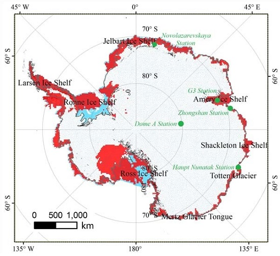
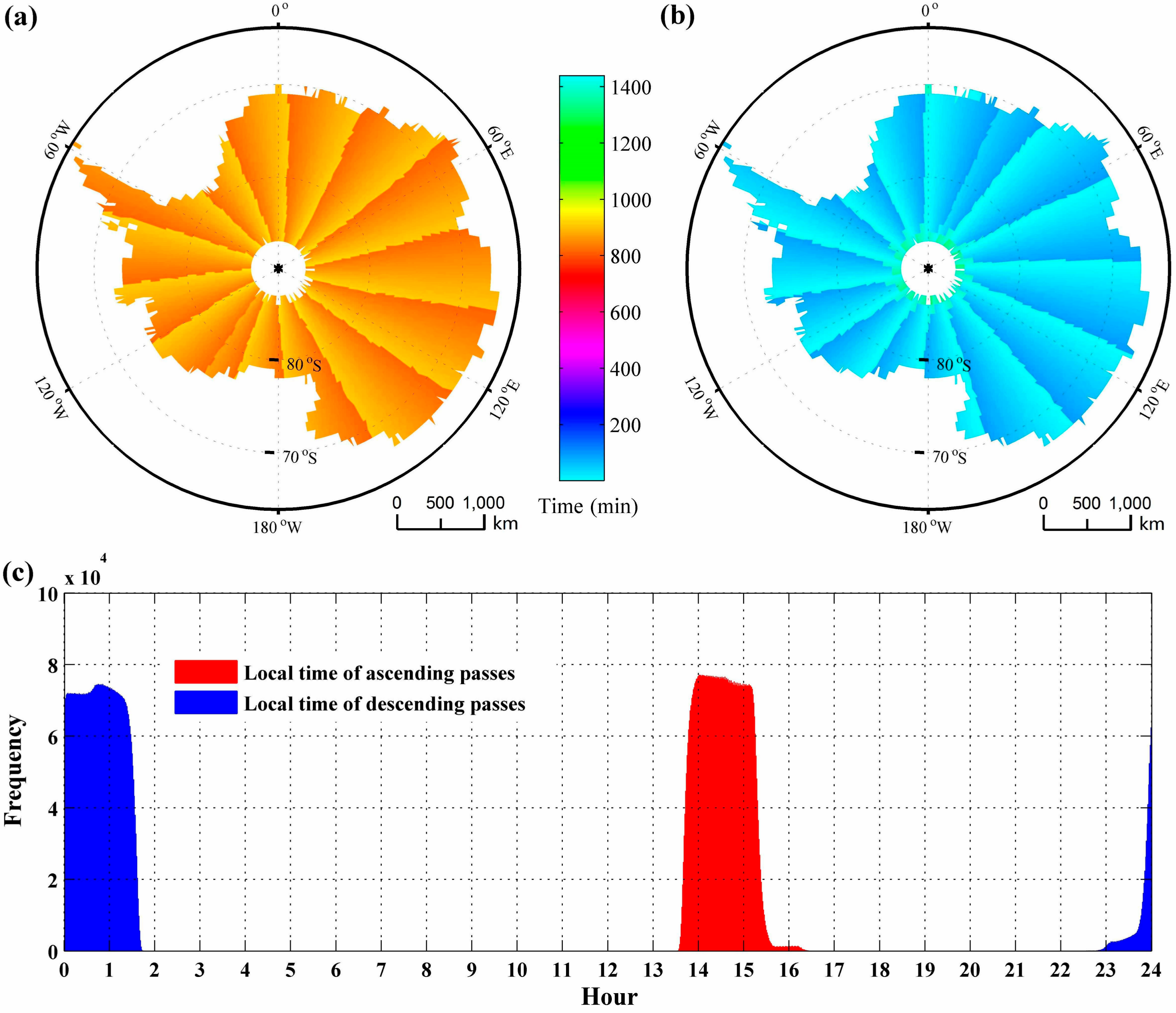
2. Data Sets
3. Methodology
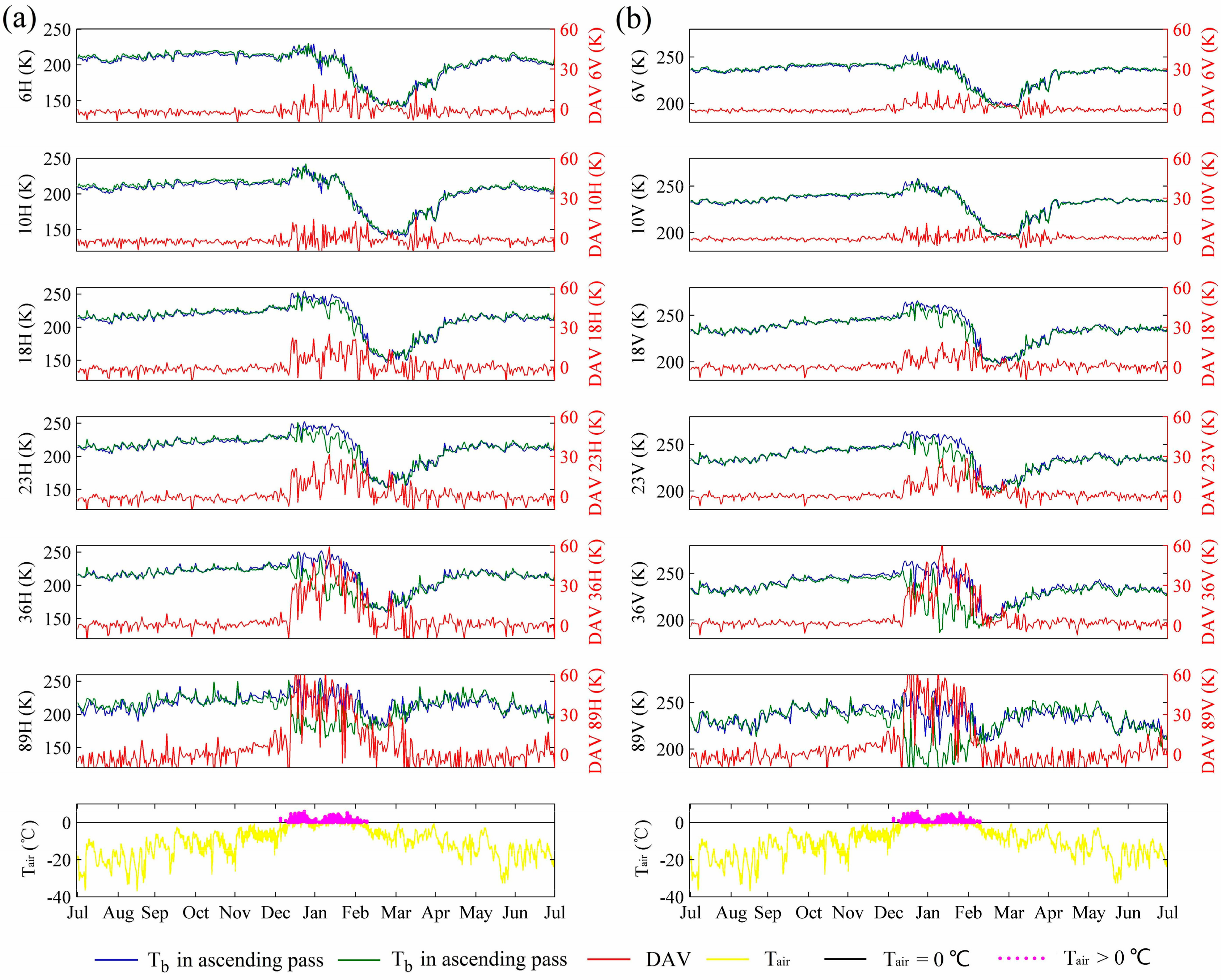
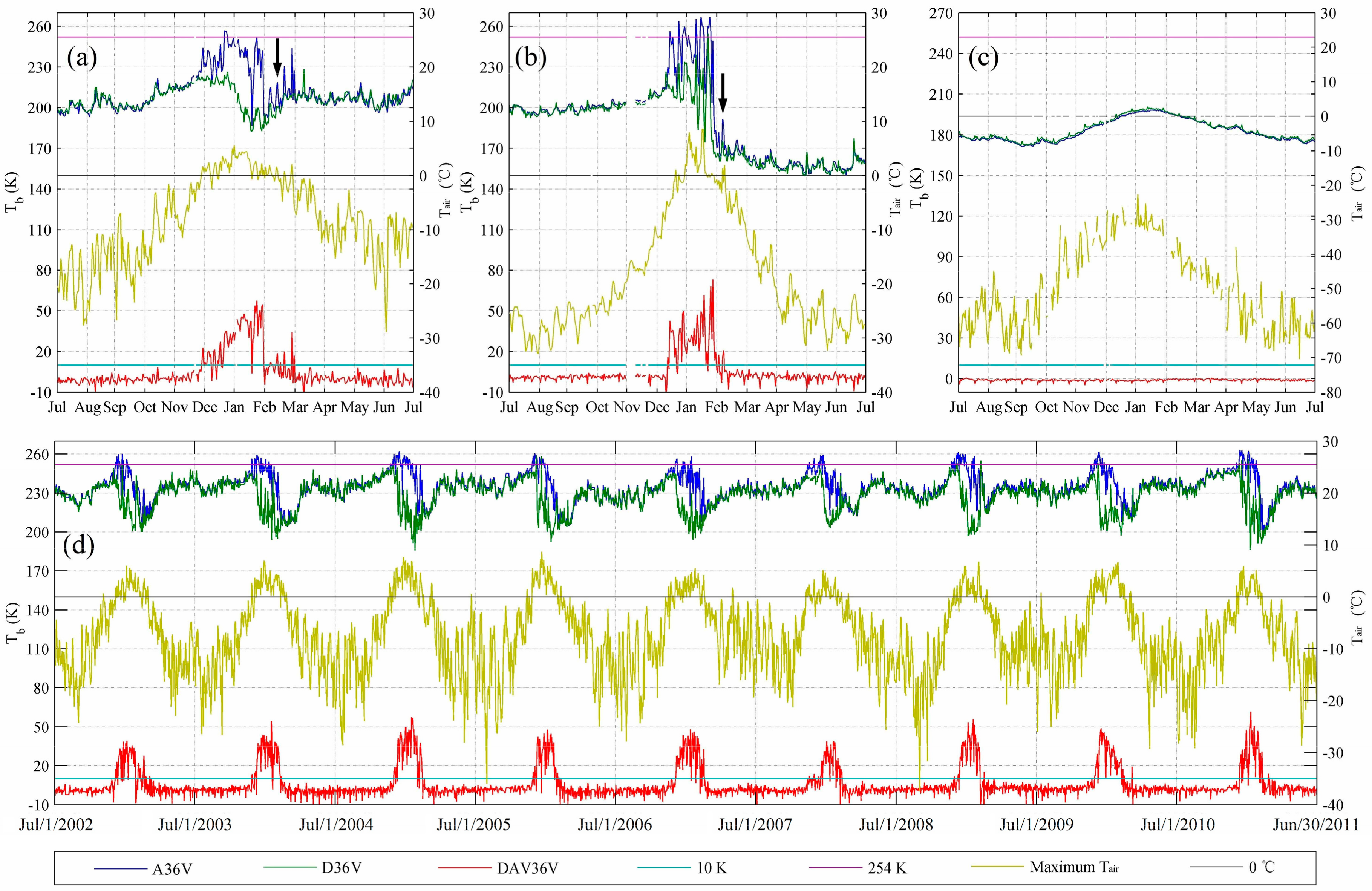
3.1. Comparisons between Tb and DAV
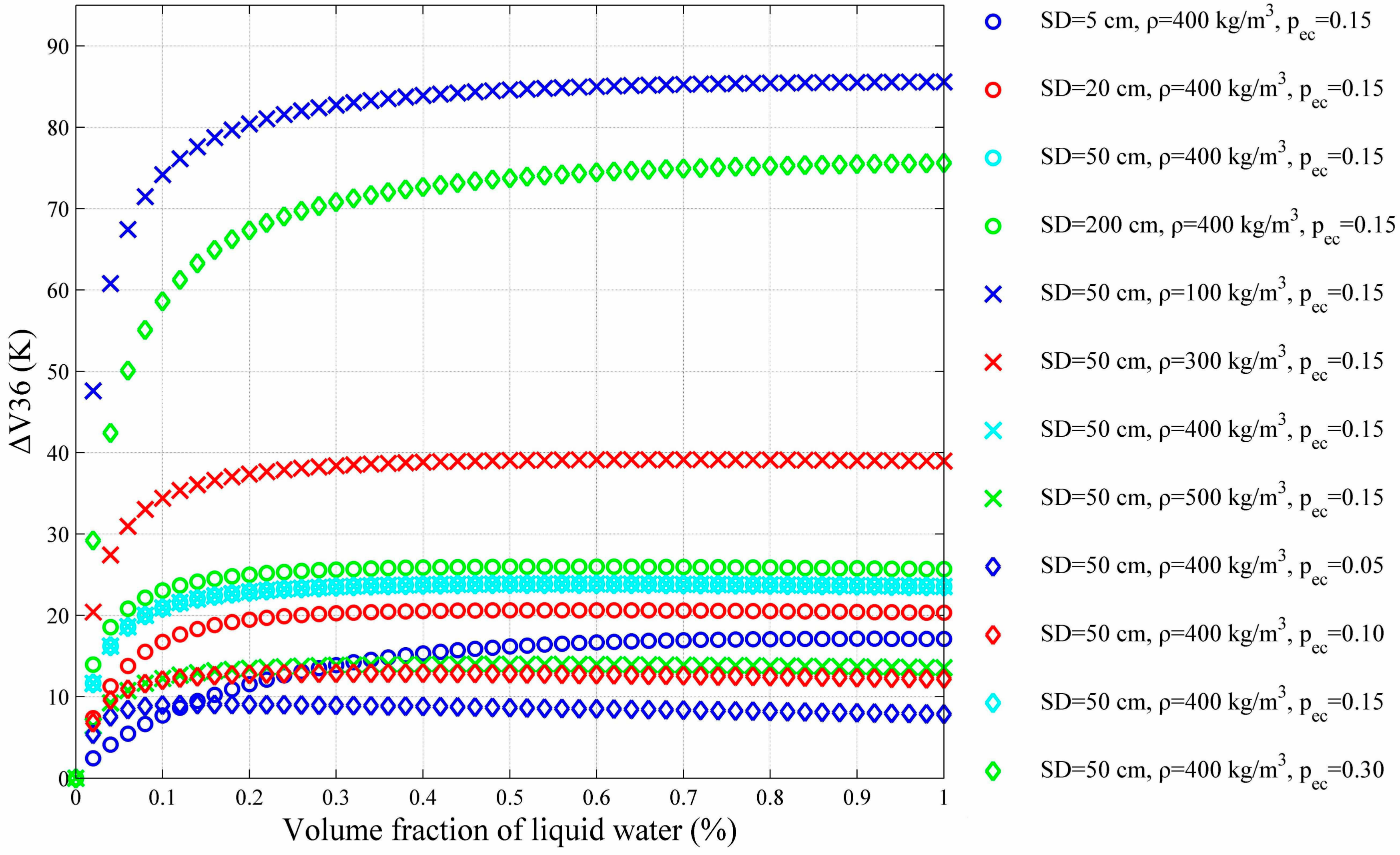
3.2. Simulations with MEMLS
3.3. Threshold for DAV36V
3.4. Elimination of False Melt
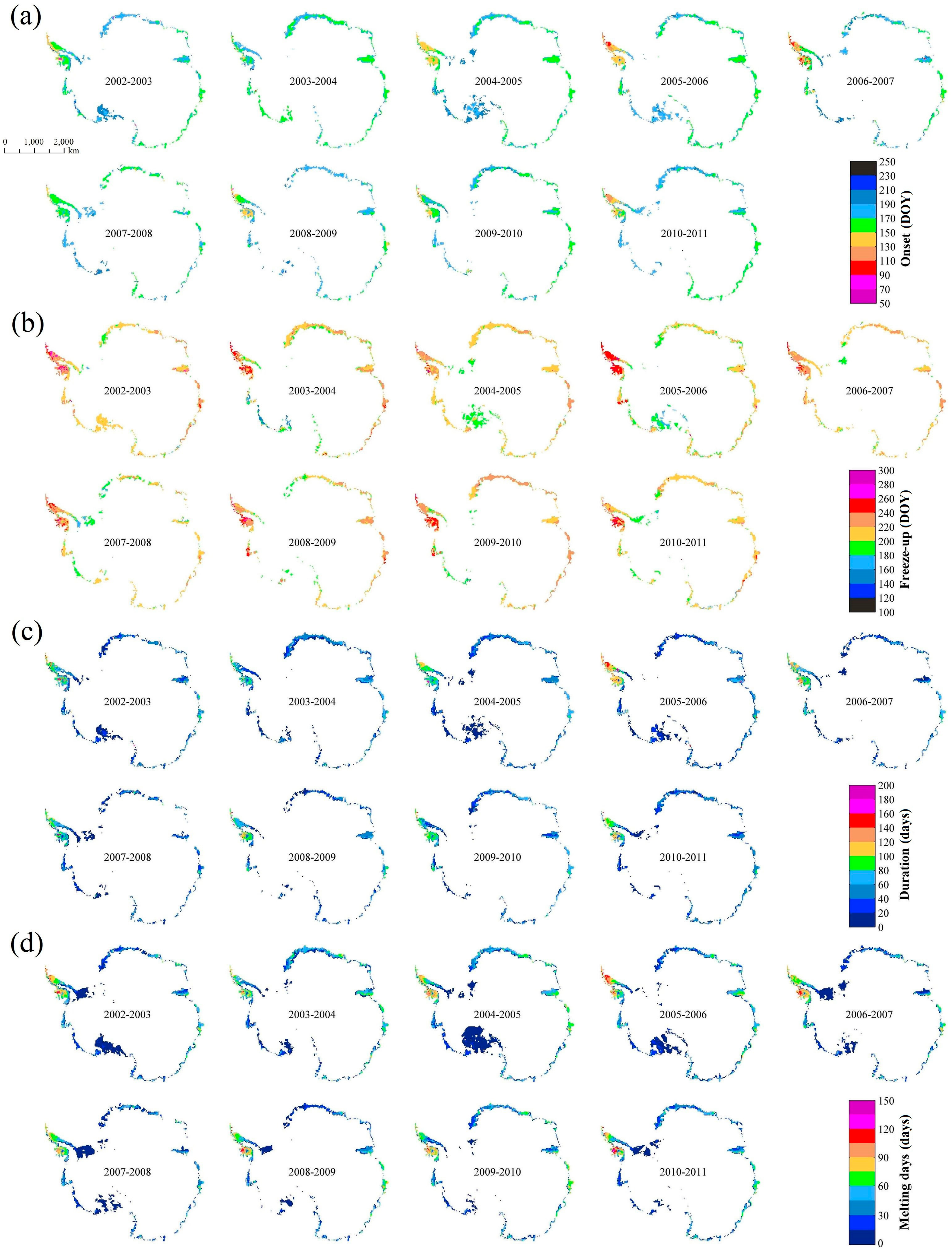
4. Spatial and Temporal Distribution of Snowmelt
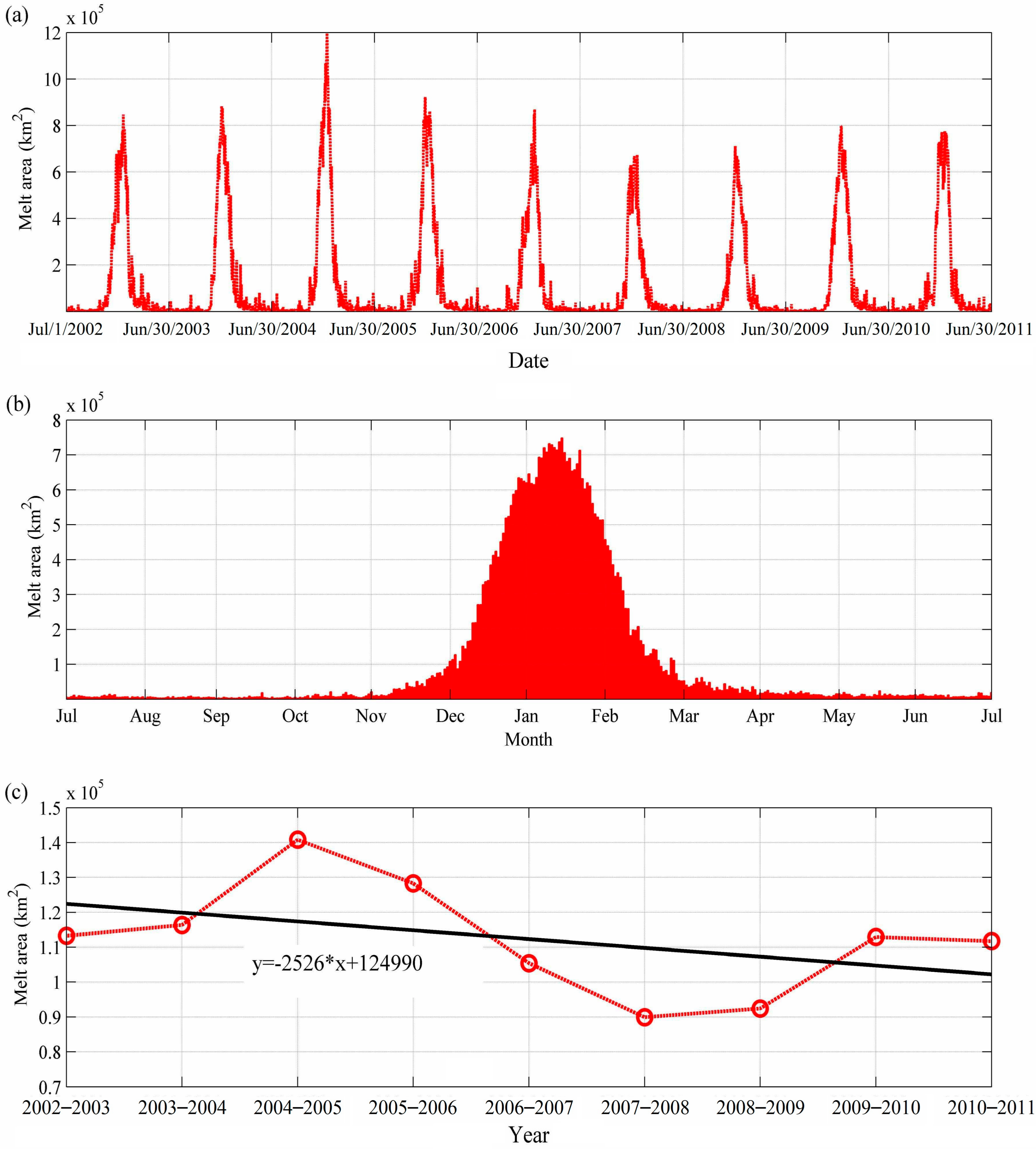
4.1. Melt Area on the Antarctic Ice Sheet
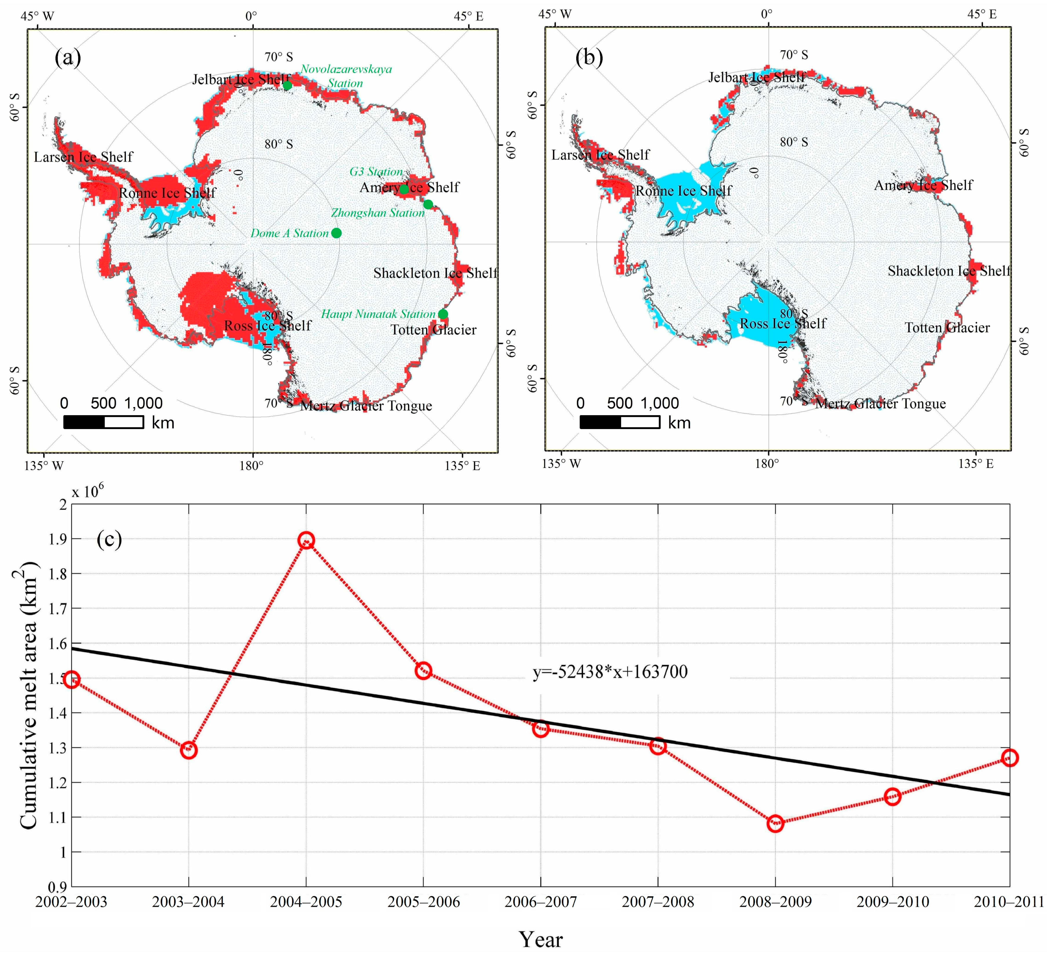
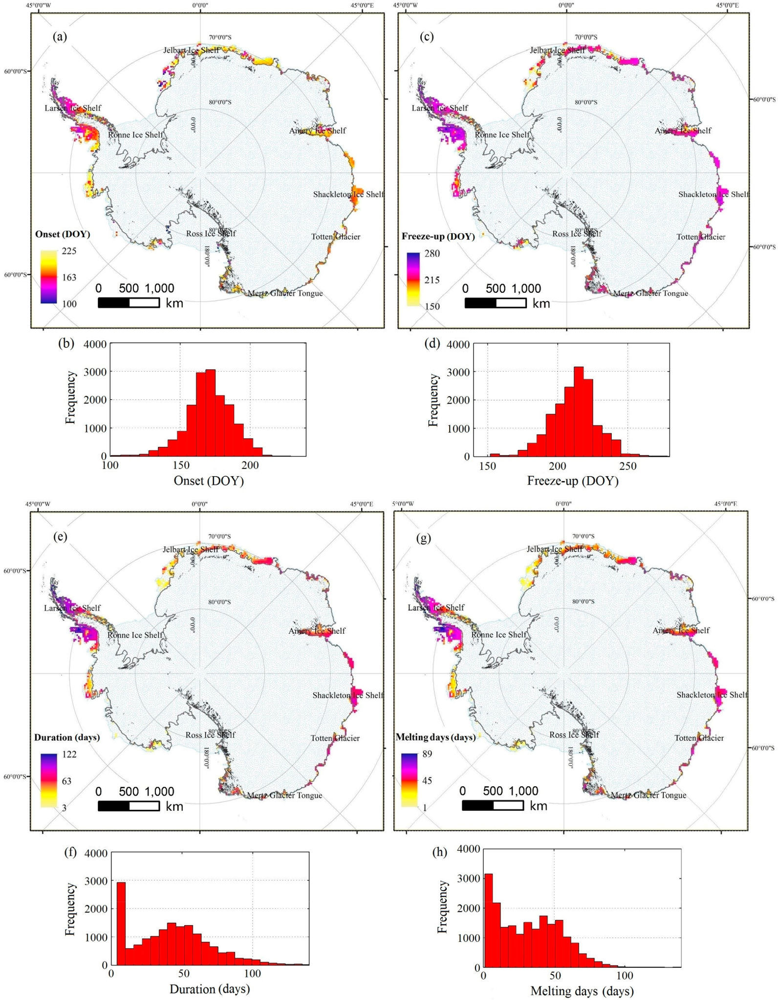
4.2. Persistent Snowmelt on the Antarctic Ice Sheet
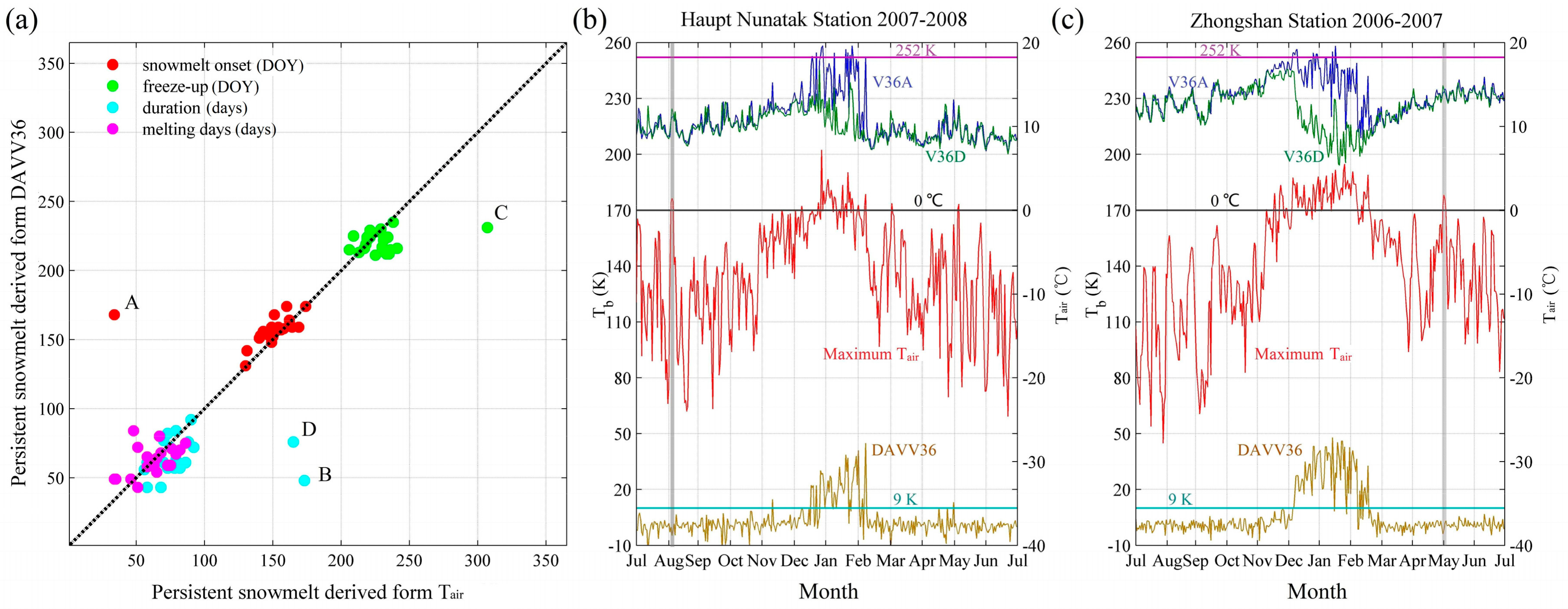
4.2.1. Validation of Persistent Snowmelt
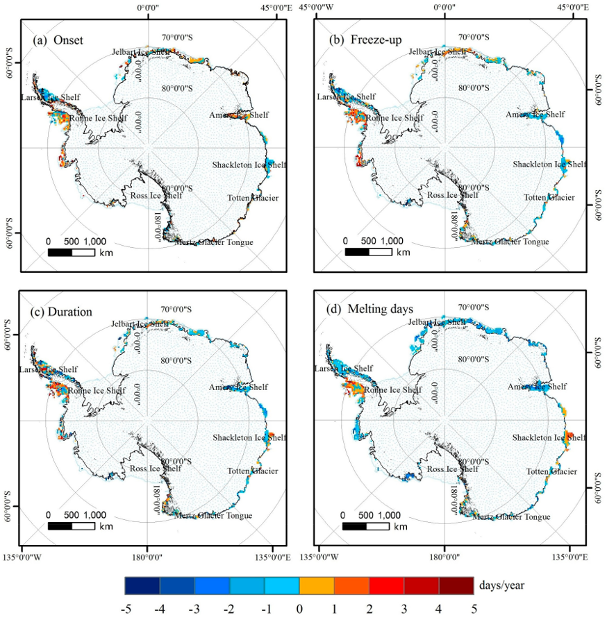
4.2.2. Persistent Snowmelt over Antarctica
5. Discussion
5.1. Uncertainties and Limitations
5.2. Comparisons and Implications
6. Conclusions
Author Contributions
Funding
Acknowledgments
Conflicts of Interest
References
- The IMBIE Team. Mass balance of the Antarctic Ice Sheet from 1992 to 2017. Nature 2018, 558, 219–222. [Google Scholar] [CrossRef] [PubMed]
- Turner, J.; Colwell, S.R.; Marshall, G.J.; Lachlan-Cope, T.A.; Carleton, A.M.; Jones, P.D.; Lagun, V.; Reid, P.A.; Iagovkina, S. Antarctic climate change during the last 50 years. Int. J. Climatol. 2005, 25, 279–294. [Google Scholar] [CrossRef]
- Depoorter, M.A.; Bamber, J.L.; Griggs, J.A.; Lenaerts, J.T.M.; Ligtenberg, S.R.M.; van den Broeke, M.R.; Moholdt, G. Calving fluxes and basal melt rates of Antarctic ice shelves. Nature 2013, 502, 89–98. [Google Scholar] [CrossRef] [PubMed]
- Liu, Y.; Moore, J.C.; Cheng, X.; Gladstone, R.M.; Bassis, J.N.; Liu, H.; Wen, J.; Hui, F. Ocean-driven thinning enhances iceberg calving and retreat of Antarctic ice shelves. Proc. Natl. Acad. Sci. USA 2015, 112, 3263–3268. [Google Scholar] [CrossRef] [PubMed]
- Picard, G.; Fily, M.; Gallee, H. Surface melting derived from microwave radiometers: A climatic indicator in Antarctica. Ann. Glaciol. 2007, 46, 29–34. [Google Scholar] [CrossRef]
- Picard, G.; Fily, M. Surface melting observations in Antarctica by microwave radiometers: Correcting 26-year time series from changes in acquisition hours. Remote Sens. Environ. 2006, 104, 325–336. [Google Scholar] [CrossRef]
- Steffen, K. Surface energy exchange at the equilibrium line on the Greenland ice sheet during onset of melt. Ann. Glaciol. 1995, 21, 13–18. [Google Scholar] [CrossRef]
- Kuipers Munneke, P.; Picard, G.; van den Broeke, M.R.; Lenaerts, J.T.M.; van Meijgaard, E. Insignificant change in Antarctic snowmelt volume since 1979. Geophys. Res. Lett. 2012, 39, L01501. [Google Scholar] [CrossRef]
- Scambos, T.; Hulbe, C.; Fahnestock, M.; Bohlander, J. The link between climate warning and break-up of ice shelves in the Antarctic Peninsula. J. Glaciol. 2000, 46, 516–530. [Google Scholar] [CrossRef]
- Van den Broeke, M. Strong surface melting preceded collapse of Antarctic Peninsula ice shelf. Geophys. Res. Lett. 2005, 32, L12815. [Google Scholar] [CrossRef]
- Abdalati, W.; Steffen, K. Greenland Ice Sheet melt extent: 1979–1999. J. Geophys. Res. Atmos. 2001, 106, 33983–33988. [Google Scholar] [CrossRef]
- Luckman, A.; Elvidge, A.; Jansen, D.; Kulessa, B.; Kuipers Munneke, P.; King, J.; Barrand, N.E. Surface melt and ponding on Larsen C Ice Shelf and the impact of föhn winds. Antarct. Sci. 2014, 26, 625–635. [Google Scholar] [CrossRef]
- Trusel, L.D.; Frey, K.E.; Das, S.B. Antarctic surface melting dynamics: Enhanced perspectives from radar scatterometer data. J. Geophys. Res. Atmos. 2012, 117, F02023. [Google Scholar] [CrossRef]
- Edgerton, A.T.; Ruskey, F.; Williams, D.; Stogryn, A.; Poe, G. Microwave Emission Characteristics of Natural Materials and the Environment (A Summary of Six Years Research); Aerojet General Corporation, EI Monte: Rancho Cordova, CA, USA, 1971. [Google Scholar]
- Liu, H.; Wang, L.; Jezek, K.C. Spatiotemporal variations of snowmelt in Antarctica derived from satellite scanning multichannel microwave radiometer and Special Sensor Microwave Imager data (1978–2004). J. Geophys. Res. 2006, 111, F01003. [Google Scholar] [CrossRef]
- Yan, B.; Weng, F.; Meng, H. Retrieval of snow surface microwave emissivity from the advanced microwave sounding unit. J. Geophys. Res. 2008, 113, D19206. [Google Scholar] [CrossRef]
- Ashcraft, I.S.; Long, D.G. Comparison of methods for melt detection over Greenland using active and passive microwave measurements. Int. J. Remote Sens. 2006, 27, 2469–2488. [Google Scholar] [CrossRef]
- Ridley, J. Surface melting on Antarctic Peninsula ice shelves detected by passive microwave sensors. Geophys. Res. Lett. 1993, 20, 2639–2642. [Google Scholar] [CrossRef]
- Zwally, H.J.; Fiegles, S. Extent and duration of Antarctic surface melting. J. Glaciol. 1994, 40, 463–475. [Google Scholar] [CrossRef]
- Mote, T.L.; Anderson, M.R. Variations in snowpack melt on the Greenland ice sheet based on passive-microwave measurements. J. Glaciol. 1995, 41, 51–60. [Google Scholar] [CrossRef]
- Wang, X.D.; Li, X.W.; Liang, L. Spatio-temporal analysis of Antarctic ice-sheet freeze-thaw variation. China Environ. Sci. 2014, 34, 1303–1309. [Google Scholar]
- Steffen, K.; Abdalati, W.; Stroeve, J. Climate sensitivity studies of the Greenland ice sheet using satellite AVHRR, SMMR, SSM/I and in situ data. Meteorol. Atmos. Phys. 1993, 51, 239–258. [Google Scholar] [CrossRef]
- Abdalati, W.; Steffen, K. Passive microwave-derived snow melt regions on the Greenland Ice Sheet. Geophys. Res. Lett. 1995, 22, 787–790. [Google Scholar] [CrossRef]
- Abdalati, W.; Steffen, K. Snowmelt on the Greenland Ice Sheet as derived from passive microwave satellite data. J. Clim. 1997, 10, 165–175. [Google Scholar] [CrossRef]
- Fahnestock, M.A.; Abdalati, W.; Shuman, C.A. Long melt seasons on ice shelves of the Antarctic Peninsula: An analysis using satellite-based microwave emission measurements. Ann. Glaciol. 2001, 34, 127–133. [Google Scholar] [CrossRef]
- Steffen, K. The melt anomaly of 2002 on the Greenland Ice Sheet from active and passive microwave satellite observations. Geophys. Res. Lett. 2004, 31, 349–371. [Google Scholar] [CrossRef]
- Fettweis, X.; van Ypersele, J.-P.; Gallée, H.; Lefebre, F.; Lefebvre, W. The 1979–2005 Greenland ice sheet melt extent from passive microwave data using an improved version of the melt retrieval XPGR algorithm. Geophys. Res. Lett. 2007, 34, L05502. [Google Scholar] [CrossRef]
- Liang, L.; Guo, H.; Li, X.; Cheng, X. Automated ice-sheet snowmelt detection using microwave radiometer measurements. Polar Res. 2013, 32, 1–13. [Google Scholar] [CrossRef]
- Joshi, M.; Merry, C.J.; Jezek, K.C.; Bolzan, J.F. An edge detection technique to estimate melt duration, season and melt extent on the Greenland Ice Sheet using Passive Microwave Data. Geophys. Res. Lett. 2001, 28, 3497–3500. [Google Scholar] [CrossRef]
- Liu, H.; Wang, L.; Jezek, K.C. Wavelet-transform based edge detection approach to derivation of snowmelt onset, end and duration from satellite passive microwave measurements. Int. J. Remote Sens. 2005, 26, 4639–4660. [Google Scholar] [CrossRef]
- Xiong, Z.; Wang, X.; Li, X.; Liang, L. Antarctic Ice-Sheet freeze-thaw detection based on improved physical model. Chin. J. Electron. 2014, 23, 209–212. [Google Scholar]
- Markus, T.; Stroeve, J.C.; Miller, J. Recent changes in Arctic sea ice melt onset, freezeup, and melt season length. J. Geophys. Res. Ocean. 2009, 114, C12024. [Google Scholar] [CrossRef]
- Hall, D.K.; Nghiem, S.V.; Schaaf, C.B.; DiGirolamo, N.E.; Neumann, G. Evaluation of surface and near-surface melt characteristics on the Greenland ice sheet using MODIS and QuikSCAT data. J. Geophys. Res. Earth Surf. 2009, 114, F04006. [Google Scholar] [CrossRef]
- Van den Broeke, M.; Bus, C.; Ettema, J.; Smeets, P. Temperature thresholds for degree-day modelling of Greenland ice sheet melt rates. Geophys. Res. Lett. 2010, 37, L18501. [Google Scholar] [CrossRef]
- Ramage, J.M.; Isacks, B.L. Determination of melt-onset and refreeze timing on southeast Alaskan icefields using SSM/I diurnal amplitude variations. Ann. Glaciol. 2002, 34, 391–398. [Google Scholar] [CrossRef]
- Ramage, J.M.; Isacks, B.L. Interannual variations of snowmelt and refreeze timing on southeast-Alaskan icefields, U.S.A. J. Glaciol. 2003, 49, 102–116. [Google Scholar] [CrossRef]
- Tedesco, M. Snowmelt detection over the Greenland ice sheet from SSM/I brightness temperature daily variations. Geophys. Res. Lett. 2007, 34, L02504. [Google Scholar] [CrossRef]
- Knowles, M.; Armstrong, R.; Brodzik, M.J. AMSR-E/Aqua Daily EASE-Grid Brightness Temperatures, Version 1. Boulder, Colorado, USA. Available online: http://nsidc.org/data/nsidc-0301 (accessed on 5 September 2015).
- Bohlander, J.; Scambos, T. Antarctic Coastlines And Grounding Line Derived from MODIS Mosaic of Antarctica (MOA), Boulder, Colorado, USA: National Snow and Ice Data Center. Available online: http://nsidc.org/data/atlas/news/antarctic_coastlines.html (accessed on 5 September 2015).
- Bamber, J.L.; Gomez-Dans, J.L.; Griggs, J.A. A new 1 km digital elevation model of the Antarctic derived from combined satellite radar and laser data—Part 1: Data and methods. Cryosphere 2008, 3, 101–111. [Google Scholar] [CrossRef]
- Griggs, J.A.; Bamber, J.L. A new 1 km digital elevation model of Antarctica derived from combined radar and laser data—Part 2: Validation and error estimates. Cryosphere 2009, 3, 113–123. [Google Scholar] [CrossRef]
- Lazzara, M.A.; Weidner, G.A.; Keller, L.M.; Thom, J.E.; Cassano, J.J. Antarctic automatic weather station program: 30 years of polar observations. Bull. Am. Meteorol. Soc. 2012, 93, 1519–1537. [Google Scholar] [CrossRef]
- Wiesmann, A.; Mätzler, C. Microwave emission model of layered snowpacks. Remote Sens. Environ. 1999, 70, 307–316. [Google Scholar] [CrossRef]
- Rees, A.; Lemmetyinen, J.; Derksen, C.; Pulliainen, J.; English, M. Observed and modelled effects of ice lens formation on passive microwave brightness temperatures over snow covered tundra. Remote Sens. Environ. 2010, 114, 116–126. [Google Scholar] [CrossRef]
- Semmens, K.A.; Ramage, J.; Bartsch, A.; Liston, G.E. Early snowmelt events: Detection, distribution, and significance in a major sub-arctic watershed. Environ. Res. Lett. 2013, 8, 014020. [Google Scholar] [CrossRef]
- Foster, J.L.; Hall, D.K.; Eylander, J.B.; Riggs, G.A.; Nghiem, S.V.; Tedesco, M.; Kim, E.; Montesano, P.M.; Kelly, R.E.J.; et al. A blended global snow product using visible, passive microwave and scatterometer satellite data. Int. J. Remote Sens. 2011, 32, 1371–1395. [Google Scholar] [CrossRef]
- Grody, N.; Weng, F.; Ferraro, R. Application of AMSU for obtaining water vapor, cloud liquid water, precipitation, snow cover, and sea ice concentration. In Proceedings of the Tenth Technical International TOVS Study Conference, Boulder, CO, USA, 27 January–2 February 1999; pp. 230–240. [Google Scholar]
- Spreen, G.; Kaleschke, L.; Heygster, G. Sea ice remote sensing using AMSR-E 89-GHz channels. J. Geophys. Res. Ocean. 2008, 113, C02S03. [Google Scholar] [CrossRef]
- Apgar, J.D.; Ramage, J.M.; Rose, A.M.; Patrick, M. AMSR-E algorithm for snowmelt onset detection in sub-arctic heterogeneous terrain. Hydrol. Process. 2007, 21, 1587–1596. [Google Scholar] [CrossRef]
- Ramage, J.M.; Apgar, J.D.; McKenney, R.A.; Hanna, W. Spatial variability of snowmelt timing from AMSR-E and SSM/I passive microwave sensors, Pelly River, Yukon Territory, Canada. Hydrol. Process. 2007, 21, 1548–1560. [Google Scholar] [CrossRef]
- Monahan, P.A.; Ramage, J. AMSR-E melt patterns on the Southern Patagonia Icefield. J. Glaciol. 2010, 56, 699–708. [Google Scholar] [CrossRef]
- Mätzler, C.; Wiesmann, A. Extension of the microwave emission model of layered snowpacks to coarse-grained snow. Remote Sens. Environ. 1999, 70, 317–325. [Google Scholar] [CrossRef]
- Tedesco, M.; Kim, E.J. Intercomparison of electromagnetic models for passive microwave remote sensing of snow. IEEE Trans. Geosci. Remote Sens. 2006, 44, 2654–2666. [Google Scholar] [CrossRef]
- Tedesco, M. Assessment and development of snowmelt retrieval algorithms over Antarctica from K-band spaceborne brightness temperature (1979–2008). Remote Sens. Environ. 2009, 113, 979–997. [Google Scholar] [CrossRef]
- Qin, D.H.; Ren, J.W. A study on snow profiles and surface characteristics along 6000 km trans-Antarctic route 1 the 1990 international trans-Antarctic expedition glaciological research. Sci. China Chem. 1992, 35, 366–374. [Google Scholar]
- Judson, A.; Doesken, N. Density of Freshly Fallen Snow in the Central Rocky Mountains. Bull. Am. Meteorol. Soc. 2000, 81, 1577–1587. [Google Scholar] [CrossRef]
- Ding, M.; Xiao, C.; Li, Y.; Ren, J.; Hou, S.; Jin, B.; Sun, B. Spatial variability of surface mass balance along a traverse route from Zhongshan station to Dome A, Antarctica. J. Glaciol. 2011, 57, 658–666. [Google Scholar]
- Davis, R.E.; Dozier, J. Stereological characterization of dry alpine snow for microwave remote sensing. Adv. Space Res. 1989, 9, 245–251. [Google Scholar] [CrossRef]
- Mätzler, C. Relation between grain-size and correlation length of snow. J. Glaciol. 2002, 48, 461–466. [Google Scholar] [CrossRef]
- Japan Aerospace Exploration Agency. AMSR-E Data Users Handbook; JAXA Earth Observation Center: Saitama, Japan, 2006. [Google Scholar]
- Powell, D.C.; Markus, T.; Cavalieri, D.J.; Gasiewski, A.J. Microwave Signatures of Snow on Sea Ice: Modeling. IEEE Trans. Geosci. Remote Sens. 2006, 44, 3091–3102. [Google Scholar] [CrossRef]
- Dai, L.; Tao, C.; Jian, W.; Pu, Z. Snow depth and snow water equivalent estimation from AMSR-E data based on a priori snow characteristics in Xinjiang, China. Remote Sens. Environ. 2012, 127, 14–29. [Google Scholar] [CrossRef]
- Hallikainen, M.T.; Ulaby, F.; Abdelrazik, M. Dielectric properties of snow in the 3 to 37 GHz range. IEEE Trans. Antennas Propag. 1986, 34, 1329–1340. [Google Scholar] [CrossRef]
- Willmes, S.; Haas, C.; Nicolaus, M.; Bareiss, J. Satellite microwave observations of the interannual variability of snowmelt on sea ice in the Southern Ocean. J. Geophys. Res. 2009, 114, C03006. [Google Scholar] [CrossRef]
- Xiao, C.; Li, Y.; Ian, A.; Hou, S.; Gabrielle, D.; Jean Marc, B.; Ren, J.; Bian, L.; Zhang, S.; Kameda, T. Surface characteristics at Dome A, Antarctica: First measurements and a guide to future ice-coring sites. Ann. Glaciol. 2008, 48, 82–87. [Google Scholar]
- Tedesco, M.; Abdalati, W.; Zwally, H.J. Persistent surface snowmelt over Antarctica (1987–2006) from 19.35 GHz brightness temperatures. Geophys. Res. Lett. 2007, 34, L18594. [Google Scholar] [CrossRef]
- Hock, R.; Braun, M. Lapse rates and their effect on melt modelling of King George Island (Antarctica). In AGU Spring Meeting Abstracts; American Geophysical Union: Monteal, QC, Canada, 2004. [Google Scholar]
- Van den Broeke, M.; König-Langlo, G.; Picard, G.; Kuipers Munneke, P.; Lenaerts, J. Surface energy balance, melt and sublimation at Neumayer Station, East Antarctica. Antarct. Sci. 2010, 22, 87–96. [Google Scholar] [CrossRef]
- Willmes, S.; Bareiss, J.; Haas, C.; Nicolaus, M. The importance of diurnal processes for the Seasonal cycle of Sea-ice microwave brightness temperatures during early Summer in the Weddell Sea, Antarctica. Ann. Glaciol. 2006, 44, 297–302. [Google Scholar] [CrossRef]
- Brucker, L.; Picard, G.; Fily, M. Snow grain-size profiles deduced from microwave snow emissivities in Antarctica. J. Glaciol. 2010, 56, 514–526. [Google Scholar] [CrossRef]
- Herron, M.M.; Langway, C.C. Firn densification: An empirical model. J. Glaciol. 1980, 25, 373–385. [Google Scholar] [CrossRef]
- Hui, F.; Ci, T.; Cheng, X.; Scambos, T.A.; Liu, Y.; Zhang, Y.; Chi, Z.; Huang, H.; Wang, X.; Wang, F.; et al. Mapping blue-ice areas in Antarctica using ETM+ and MODIS data. Ann. Glaciol. 2014, 55, 129–137. [Google Scholar] [CrossRef]
- Kingslake, J.; Ely, J.C.; Das, I.; Bell, R.E. Widespread movement of meltwater onto and across Antarctic ice shelves. Nature 2017, 544, 349–352. [Google Scholar] [CrossRef] [PubMed]
- Eppler, D.T.; Farmer, L.D.; Lohanick, A.W.; Anderson, M.R.; Cavalieri, D.J.; Comiso, J.; Gloersen, P.; Garrity, C.; Grenfell, T.C.; Hallikainen, M.; et al. Passive Microwave Signatures of Sea Ice; American Geophysical Union: Washington, DC, USA, 1992; p. 55. [Google Scholar]
- Wentz, F.J.; Meissner, T. Supplement 1 Algorithm Theoretical Basis Document for AMSR-E Ocean Algorithms; NASA: Santa Rosa, CA, USA, 2007.
- Steiner, N.; Tedesco, M. A wavelet melt detection algorithm applied to enhanced-resolution scatterometer data over Antarctica (2000–2009). Cryosphere 2014, 8, 25–40. [Google Scholar] [CrossRef]
- Bothale, R.V.; Rao, P.V.N.; Dutt, C.B.S.; Dadhwal, V.K.; Maurya, D. Spatio-temporal dynamics of surface melting over Antarctica using OSCAT and QuikSCAT scatterometer data (2001–2014). Curr. Sci. 2015, 109, 733–744. [Google Scholar]
- Zhou, C.; Zheng, L. Mapping Radar Glacier Zones and Dry Snow Line in the Antarctic Peninsula Using Sentinel-1 Images. Remote Sens. 2017, 9, 1171. [Google Scholar] [CrossRef]
- Tedesco, M.; Monaghan, A.J. An updated Antarctic melt record through 2009 and its linkages to high-latitude and tropical climate variability. Geophys. Res. Lett. 2009, 36, L18502. [Google Scholar] [CrossRef]
- Monaghan, A.J.; Bromwich, D.H.; Chapman, W.; Comiso, J.C. Recent variability and trends of Antarctic near-surface temperature. J. Geophys. Res. Atmos. 2008, 113, D04105. [Google Scholar] [CrossRef]
- Clem, K.R.; Fogt, R.L. South Pacific circulation changes and their connection to the tropics and regional Antarctic warming in austral spring, 1979–2012. J. Geophys. Res. Atmos. 2015, 120, 2773–2792. [Google Scholar] [CrossRef]
- Fettweis, X.; Gallée, H.; Lefebre, F.; van Ypersele, J.P. Greenland surface mass balance simulated by a regional climate model and comparison with satellite-derived data in 1990–1991. Clim. Dyn. 2005, 24, 623–640. [Google Scholar] [CrossRef]
- Rignot, E.; Casassa, G.; Gogineni, P.; Krabill, W.; Rivera, A.; Thomas, R. Accelerated ice discharge from the Antarctic Peninsula following the collapse of Larsen B ice shelf. Geophys. Res. Lett. 2004, 31, L18401. [Google Scholar] [CrossRef]


© 2018 by the authors. Licensee MDPI, Basel, Switzerland. This article is an open access article distributed under the terms and conditions of the Creative Commons Attribution (CC BY) license (http://creativecommons.org/licenses/by/4.0/).
Share and Cite
Zheng, L.; Zhou, C.; Liu, R.; Sun, Q. Antarctic Snowmelt Detected by Diurnal Variations of AMSR-E Brightness Temperature. Remote Sens. 2018, 10, 1391. https://doi.org/10.3390/rs10091391
Zheng L, Zhou C, Liu R, Sun Q. Antarctic Snowmelt Detected by Diurnal Variations of AMSR-E Brightness Temperature. Remote Sensing. 2018; 10(9):1391. https://doi.org/10.3390/rs10091391
Chicago/Turabian StyleZheng, Lei, Chunxia Zhou, Ruixi Liu, and Qizhen Sun. 2018. "Antarctic Snowmelt Detected by Diurnal Variations of AMSR-E Brightness Temperature" Remote Sensing 10, no. 9: 1391. https://doi.org/10.3390/rs10091391
APA StyleZheng, L., Zhou, C., Liu, R., & Sun, Q. (2018). Antarctic Snowmelt Detected by Diurnal Variations of AMSR-E Brightness Temperature. Remote Sensing, 10(9), 1391. https://doi.org/10.3390/rs10091391