The Comparison of Canopy Height Profiles Extracted from Ku-band Profile Radar Waveforms and LiDAR Data
Abstract
1. Introduction
2. Materials and Methods
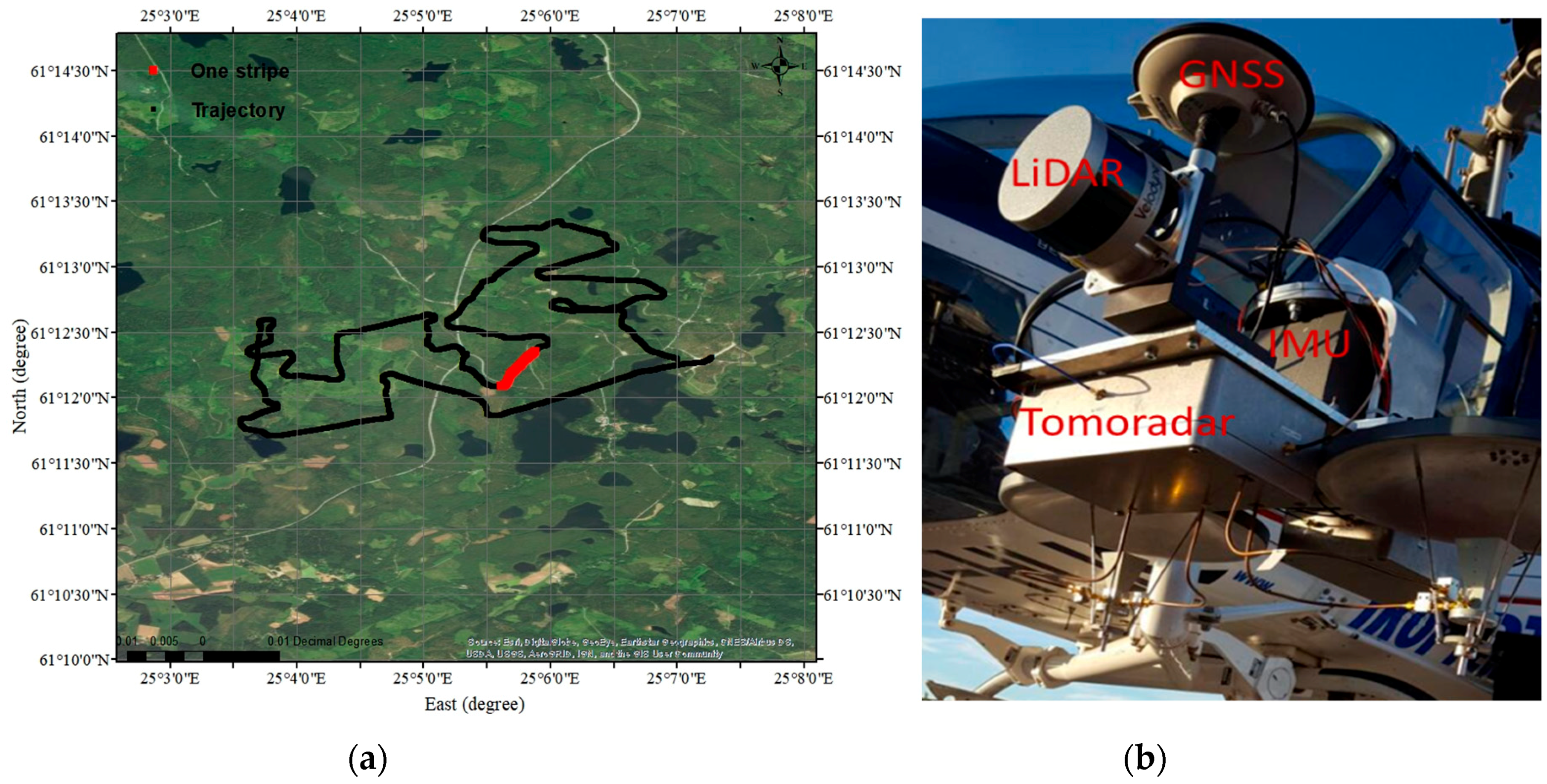
2.1. Site Description
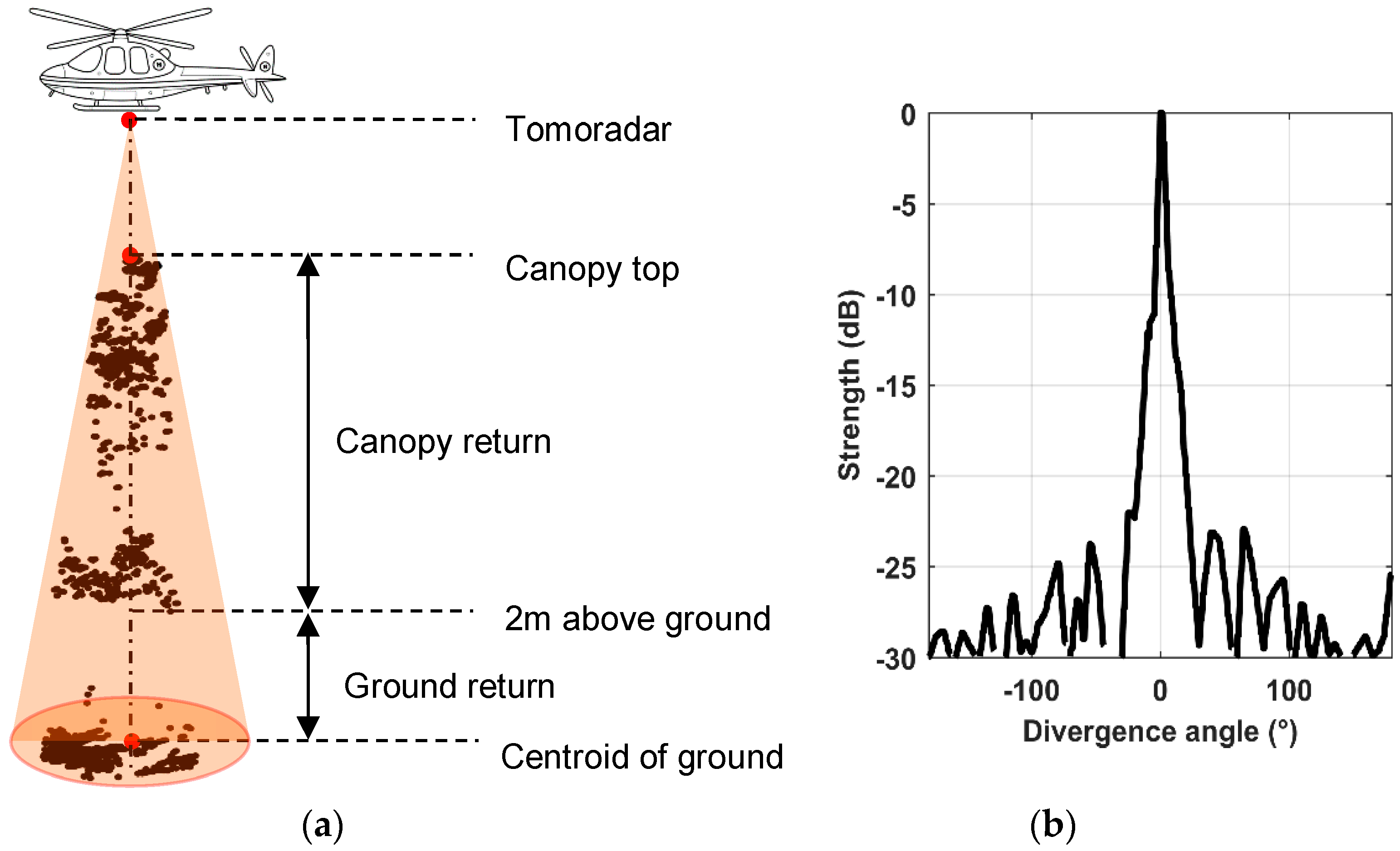
2.2. Tomoradar Waveforms
2.3. LiDAR Data
2.4. Methods
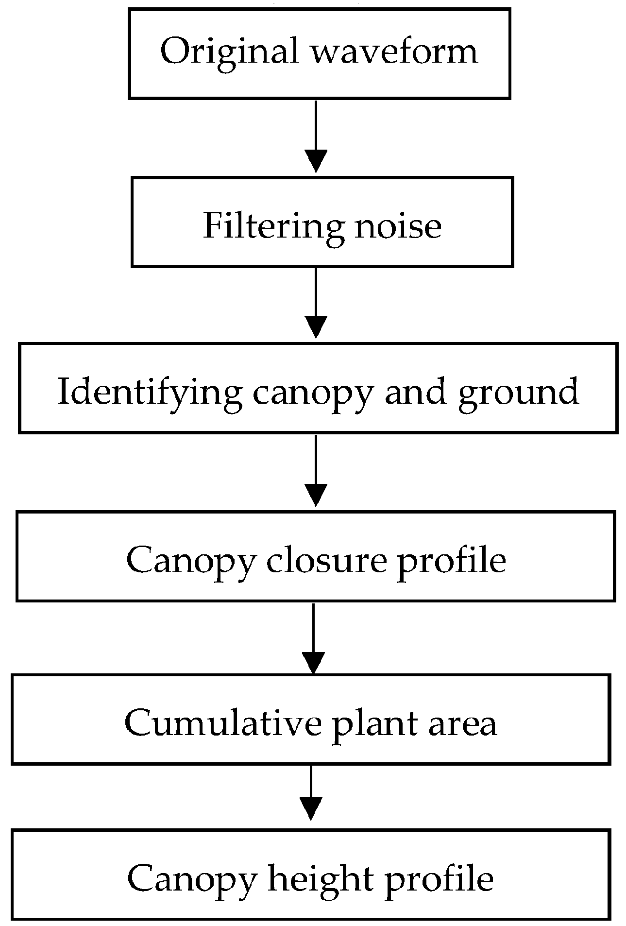
2.4.1. Derivation of Canopy Height Profile from Tomoradar Waveforms
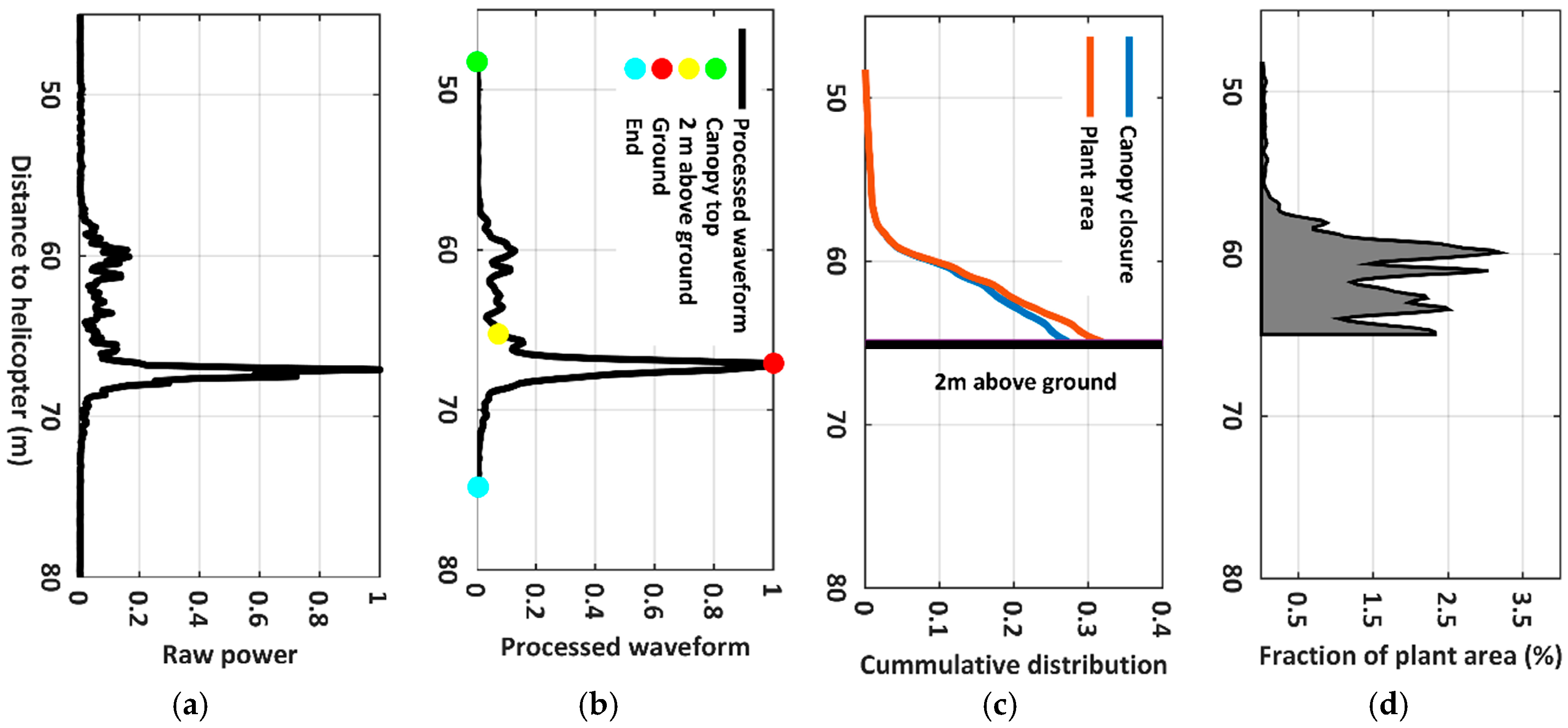
(1) Filtering Noise for Raw Power Waveform
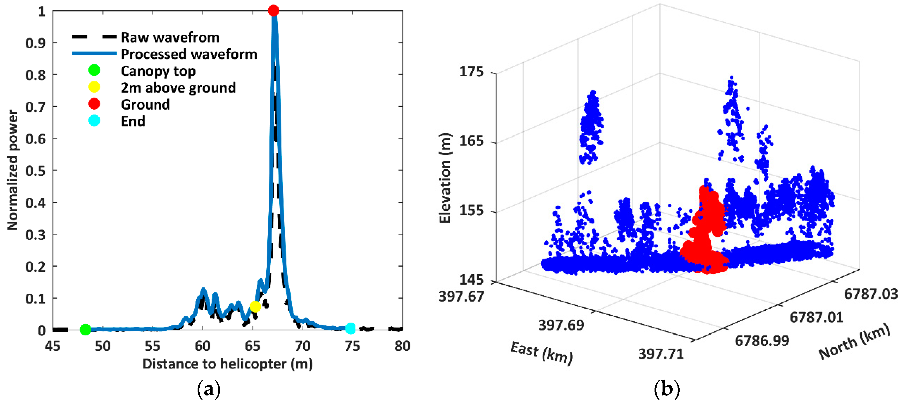
(2) Identifying Canopy and Ground
(3) Canopy Closure Profile
(4) Cumulative Distribution of the Plant Area
(5) The CHP Extracted from Tomoradar Waveforms
2.4.2. Derivation of Canopy Height Profile from LiDAR Data
2.4.3. Comparison Method
3. Results and Discussion
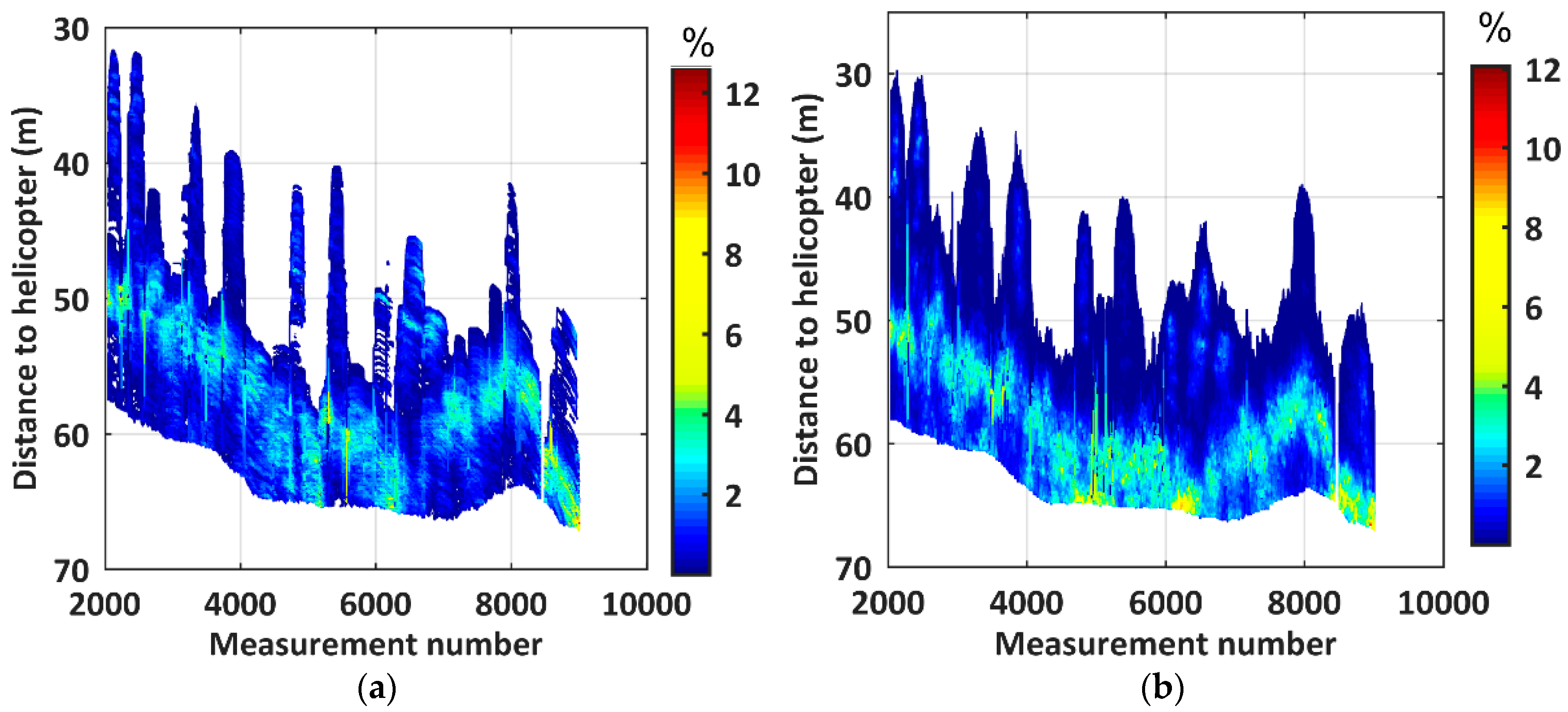
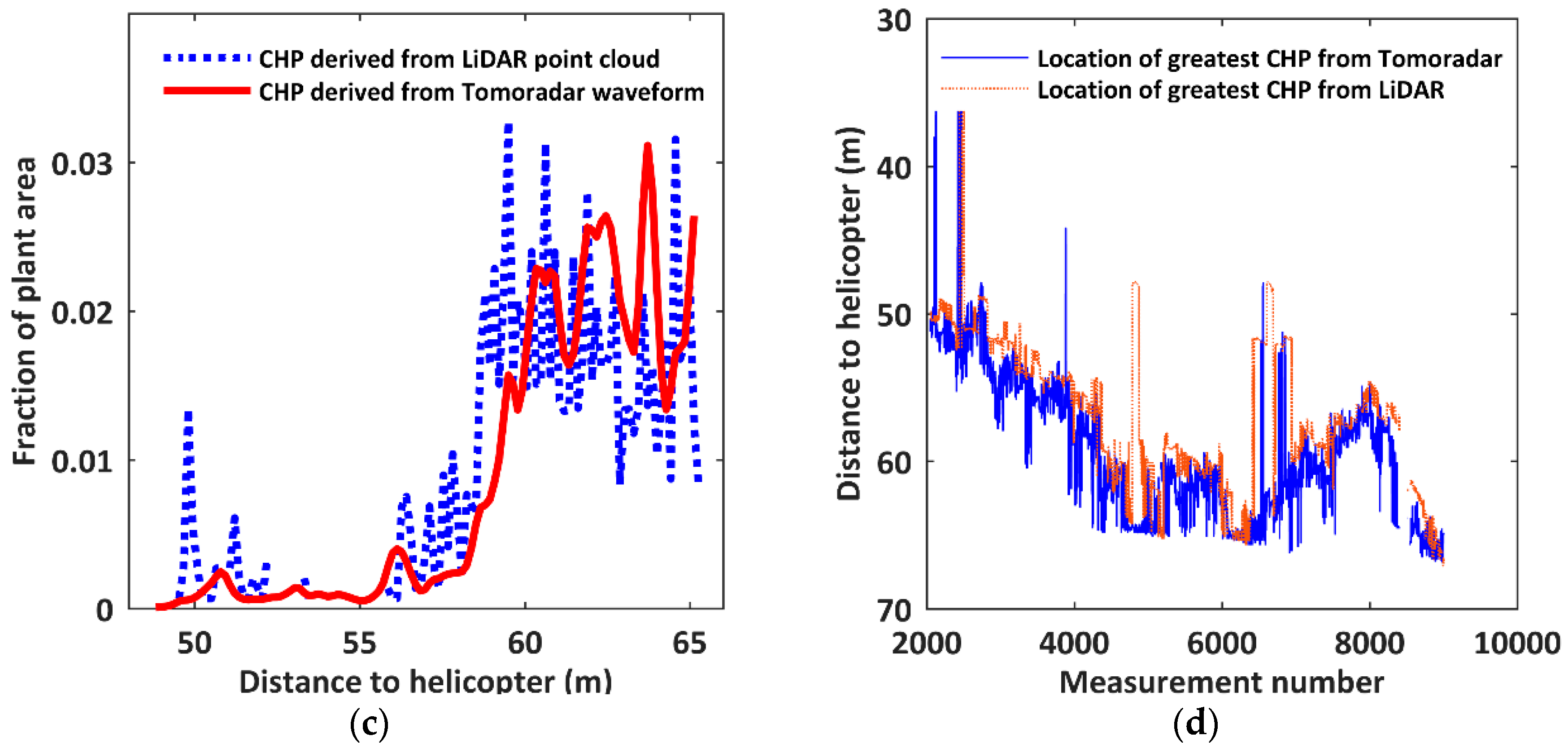
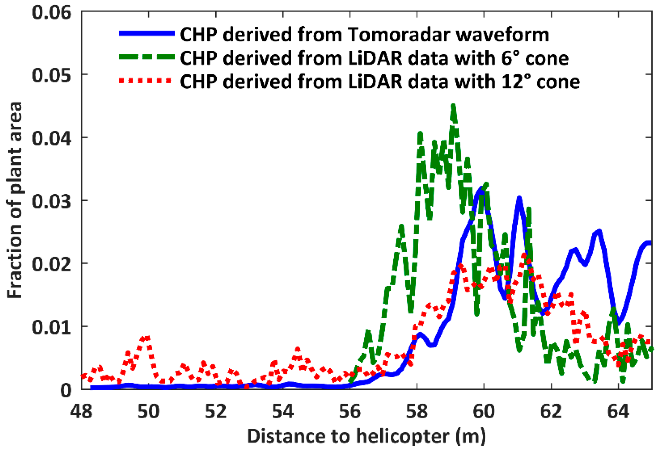
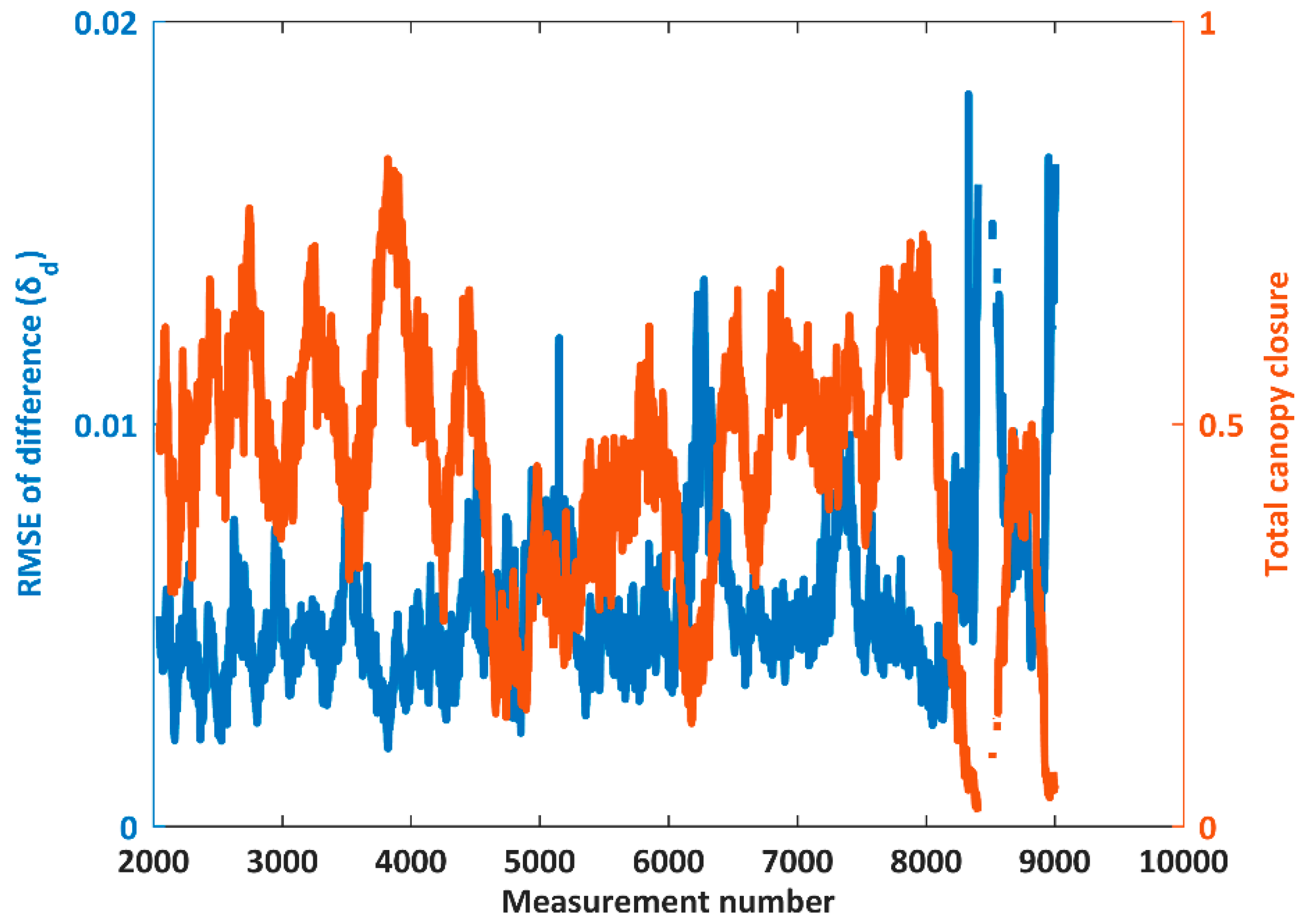
3.1. Analysis of the Differences of the CHPs
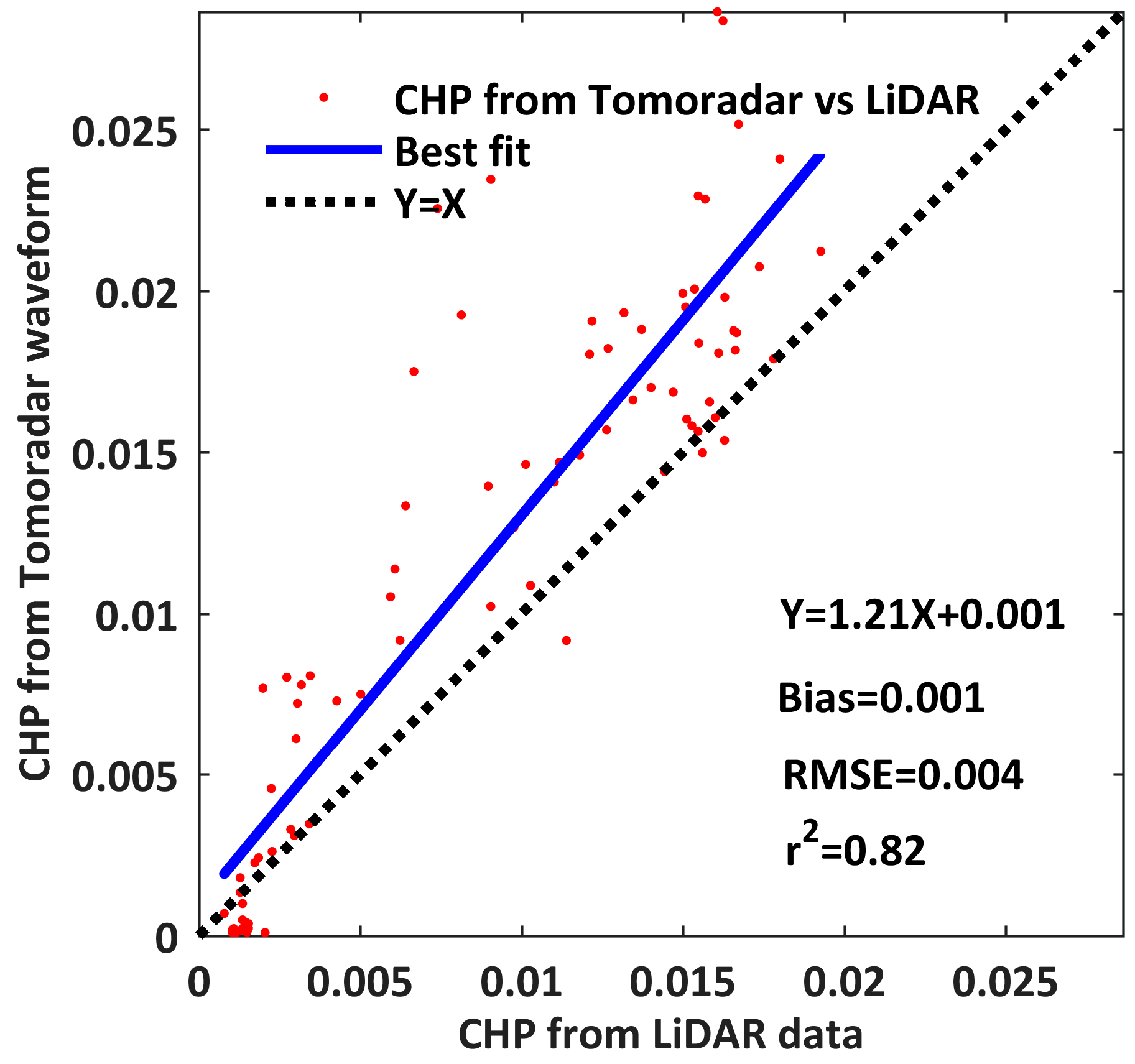
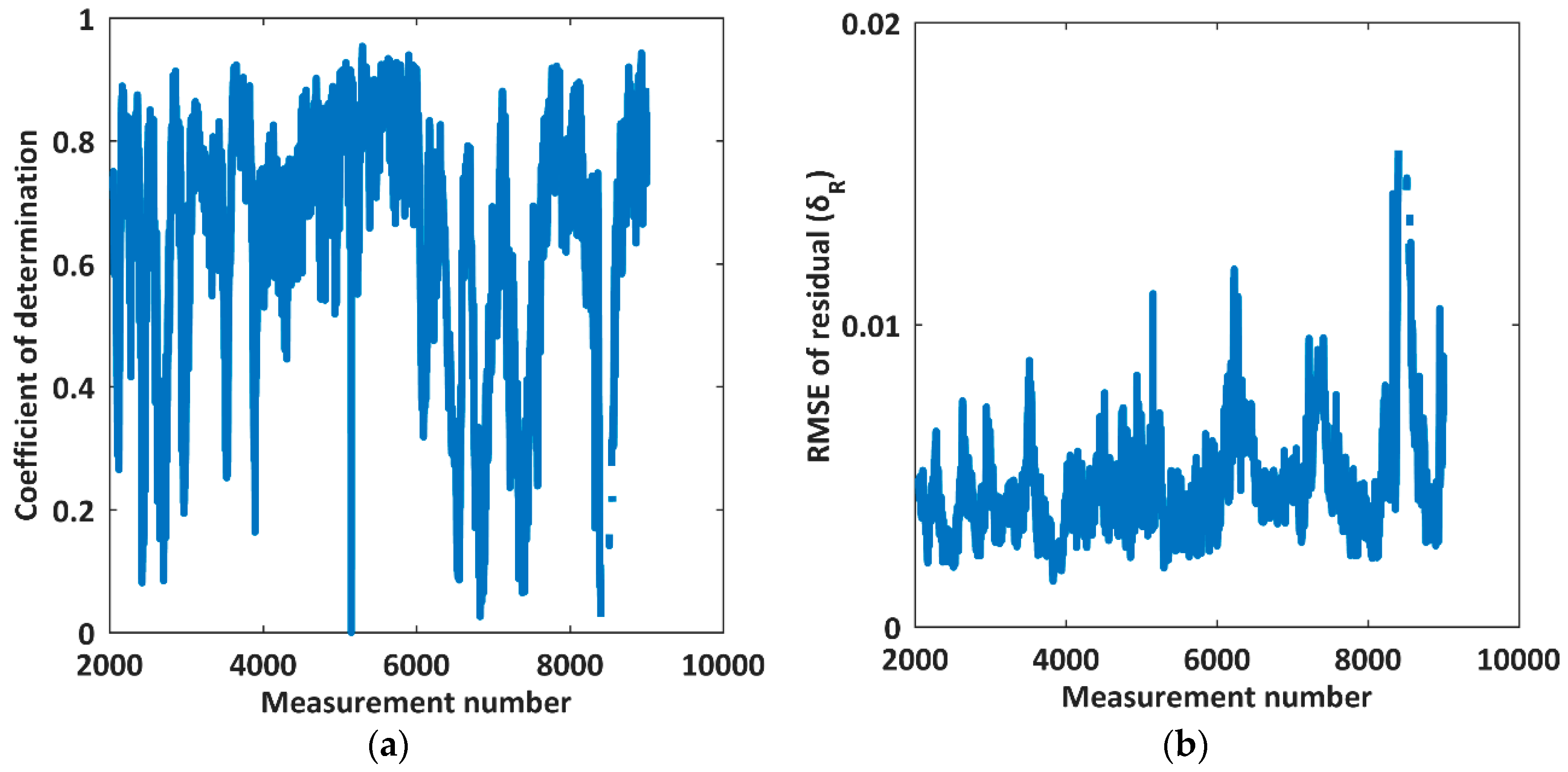
3.2. Linear Regression Results
4. Conclusions
Author Contributions
Acknowledgments
Conflicts of Interest
References
- Forest Definition and Extent”. United Nations Environment Programme. Available online: https://web.archive.org/web/20100726140947/http://www.unep.org/vitalforest/Report/VFG-01-Forest-definition-and-extent.pdf (accessed on 10 April 2018).
- Brokaw, N.; Lent, R. Vertical Structure. In Maintaining Biodiversity in Forest Ecosystems; Hunter, M., Ed.; Cambridge University Press: Boston, MA, USA, 1999; pp. 373–399. [Google Scholar]
- Wilson, J.W. Stand structure and light penetration. I. Analysis by point quadrats. J. Appl. Ecol. 1965, 2, 383–390. [Google Scholar] [CrossRef]
- Macarthur, R.H.; Horn, H.S. Foliage profile by vertical measurements. Ecology 1969, 50, 802–804. [Google Scholar] [CrossRef]
- Aber, J.D. A method for estimating foliage-height profiles in broad-leaved forests. J. Ecol. 1979, 67, 35–40. [Google Scholar] [CrossRef]
- Gong, P.; Mei, X.; Biging, G.S.; Zhang, Z. Improvement of an oak canopy model extracted from digital photogrammetry. Photogramm. Eng. Remote Sens. 2002, 63, 919–924. [Google Scholar]
- Sheng, Y.; Gong, P.; Biging, G.S. Model-Based Conifer canopy Surface Reconstruction form Photographic Imagery: Overcoming the Occlusion, Foreshortening, and Edge Effects. Photogramm. Eng. Remote Sens. 2003, 69, 249–258. [Google Scholar] [CrossRef]
- Song, C.; Dickinson, M.B. Extracting forest canopy structure from spatial information of high resolution optical imagery: tree crown size versus leaf area index. Int. J. Remote Sens. 2008, 29, 5605–5622. [Google Scholar] [CrossRef]
- Alonzo, M.; Bookhagen, B.; McFadden, J.P.; Sun, A.; Roberts, D.A. Mapping urban forest leaf area index with airborne lidar using penetration metrics and allometry. Remote Sens. Environ. 2015, 162, 141–153. [Google Scholar] [CrossRef]
- Lovell, J.L.; Jupp, D.L.; Culvenor, D.S.; Coops, N.C. Using airborne and ground-based ranging lidar to measure canopy structure in Australian forests. Can. J. Remote Sens. 2003, 29, 607–622. [Google Scholar] [CrossRef]
- Coops, N.C.; Hilker, T.; Wulder, M.A.; St-Onge, B.; Newnham, G.; Siggins, A.; Trofymow, J.T. Estimating canopy structure of Douglas-fir forest stands from discrete-return LiDAR. Trees 2007, 21, 295. [Google Scholar] [CrossRef]
- Wilkes, P. Assessment of Forest Canopy Vertical Structure with Multi-Scale Remote sensing: From the Plot to the Large Area. Ph.D. Thesis, University of Twente, Enschede, The Netherlands, 2015. [Google Scholar]
- Zhang, Z.; Cao, L.; She, G. Estimating Forest Structural Parameters Using Canopy Metrics Derived from Airborne LiDAR Data in Subtropical Forests. Remote Sens. 2017, 9, 940. [Google Scholar] [CrossRef]
- Lefsky, M.A.; Cohen, W.B.; Acker, S.A.; Parker, G.G.; Spies, T.A.; Harding, D. Lidar remote sensing of the canopy structure and biophysical properties of Douglas-fir western hemlock forests. Remote Sens. Environ. 1999, 70, 339–361. [Google Scholar] [CrossRef]
- Harding, D.J.; Lefsky, M.A.; Parker, G.G.; Blair, J.B. Laser altimeter canopy height profiles: Methods and validation for closed-canopy, broadleaf forests. Remote Sens. Environ. 2001, 76, 283–297. [Google Scholar] [CrossRef]
- Allouis, T.; Durrieu, S.; Véga, C.; Couteron, P. Stem volume and above-ground biomass estimation of individual pine trees from LiDAR data: Contribution of full-waveform signals. IEEE J. Sel. Top. Appl. Earth Obse. Remote Sens. 2013, 6, 924–934. [Google Scholar] [CrossRef]
- Fieber, K.D.; Davenport, I.J.; Tanase, M.A.; Ferryman, J.M.; Gurney, R.J.; Becerra, V.M.; Hacker, J.M. Validation of Canopy Height Profile methodology for small-footprint full-waveform airborne LiDAR data in a discontinuous canopy environment. ISPRS J. Photogramm. Remote Sens. 2015, 104, 144–157. [Google Scholar] [CrossRef]
- Hermosilla, T.; Ruiz, L.A.; Kazakova, A.N.; Coops, N.C.; Moskal, L.M. Estimation of forest structure and canopy fuel parameters from small-footprint full-waveform LiDAR data. Int. J. Wildland Fire 2014, 22, 224–233. [Google Scholar] [CrossRef]
- Piermattei, L.; Hollaus, M.; Pfeifer, N.; Chen, Y.; Karjalainen, M.; Hakala, T.; Hyyppä, J.; Wagner, W. Comparing helicopter-borne profiling radar with airborne laser scanner data for forest structure estimation. In Proceedings of the EGU General Assembly Conference Abstracts, Vienna, Austria, 23–28 April 2017; Volume 19, p. 13741. [Google Scholar]
- Feng, Z.; Chen, Y.; Hakala, T.; Hyyppä, J. Range calibration of airborne profiling radar used in forest inventory. In Proceedings of the Geoscience and Remote Sensing Symposium (IGARSS), Beijing, China, 10–15 July 2016; pp. 6672–6675. [Google Scholar]
- Piermattei, L.; Hollaus, M.; Milenković, M.; Pfeifer, N.; Quast, R.; Chen, Y.; Hakala, T.; Karjalainen, M.; Hyyppä, J.; Wagner, W. An Analysis of Ku-Band Profiling Radar Observations of Boreal Forest. Remote Sens. 2017, 9, 1252. [Google Scholar] [CrossRef]
- Le Toan, T.; Beaudoin, A.; Riom, J.; Guyon, D. Relating forest biomass to SAR Data. IEEE Trans. Geosci. Remote Sens. 1992, 30, 403–411. [Google Scholar] [CrossRef]
- Yu, X.; Hyyppä, J.; Karjalainen, M.; Nurminen, K.; Karila, K.; Vastaranta, M.; Kankare, V.; Kaartinen, H.; Holopainen, M.; Honkavaara, E.; Kukko, A.; et al. Comparison of Laser and Stereo Optical, SAR and InSAR Point Clouds from Air- and Space-Borne Sources in the Retrieval of Forest Inventory Attributes. Remote Sens. 2015, 7, 15933–15954. [Google Scholar] [CrossRef]
- Chen, Y.; Hakala, T.; Karjalainen, M.; Feng, Z.; Tang, J.; Litkey, P.; Kukko, A.; Jaakkola, A.; Hyyppä, J. UAV-Borne Profiling Radar for Forest Research. Remote Sens. 2017, 9, 58. [Google Scholar] [CrossRef]
- User’s Manual and Programming Guide VLP-16 Velodyne LiDAR. Available online: http://velodynelidar.com/docs/manuals/63-9243%20Rev%20B%20User%20Manual%20and%20Programming%20Guide,VLP-16.pdf (accessed on 10 April 2018).
- Parrish, C.E.; Jeong, I.; Nowak, R.D.; Smith, R.B. Empirical comparison of full-waveform lidar algorithms. Photogramm. Eng. Remote Sens. 2011, 77, 825–838. [Google Scholar] [CrossRef]
- Morsdorf, F.; Kötz, B.; Meier, E.; Itten, K.I.; Allgöwer, B. Estimation of LAI and fractional cover from small footprint airborne laser scanning data based on gap fraction. Remote Sens. Environ. 2006, 104, 50–61. [Google Scholar] [CrossRef]
- Feng, Z.; Chen, Y.; Hyyppä, J.; Hakala, T.; Zhou, H.; Wang, Y.; Karjalainen, M. Estimating Ground Level and Canopy Top Elevation with Airborne Microwave Profiling Radar. IEEE Trans. Geosci. Remote Sens. 2018, 99, 1–12. [Google Scholar] [CrossRef]

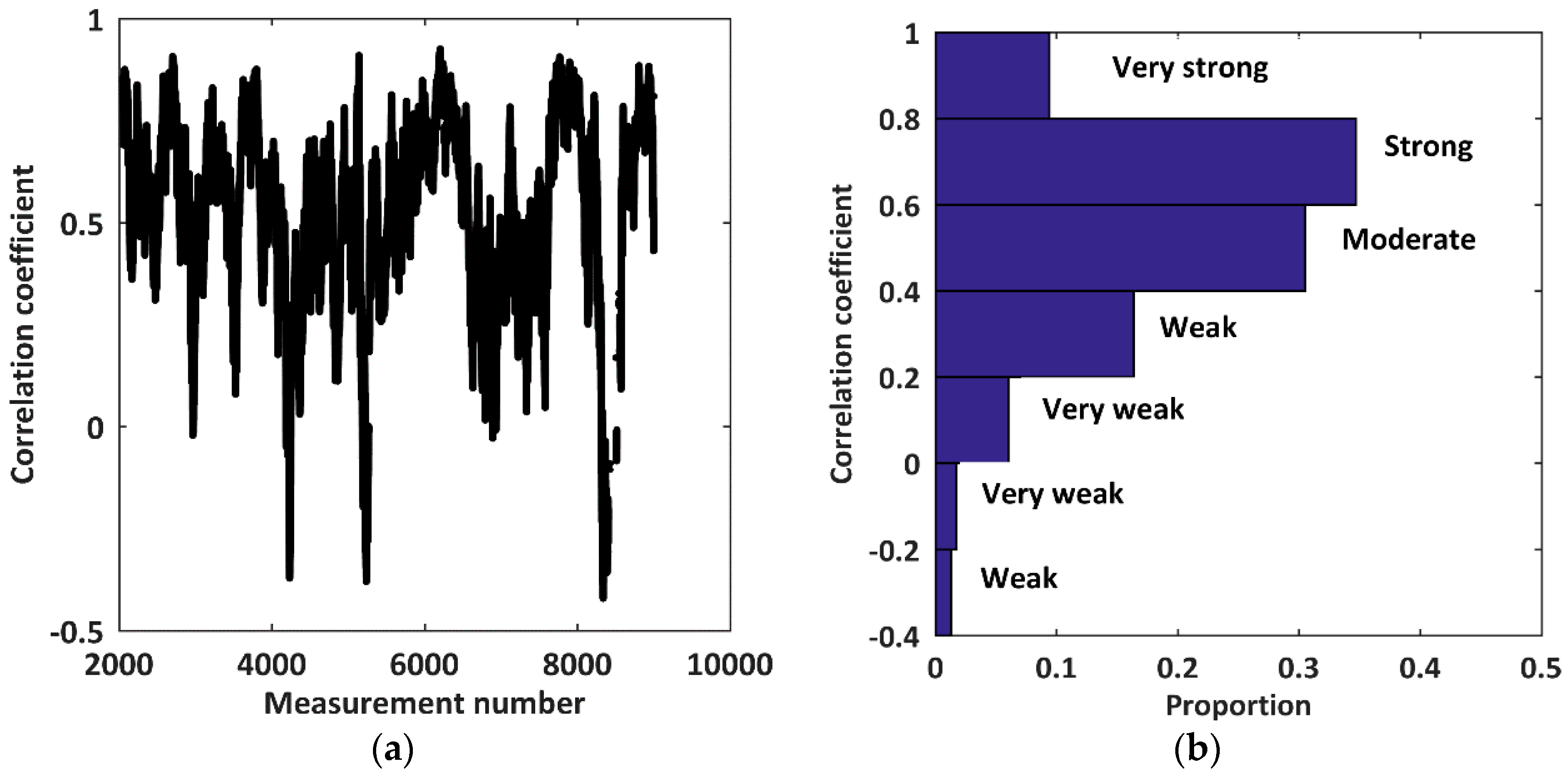
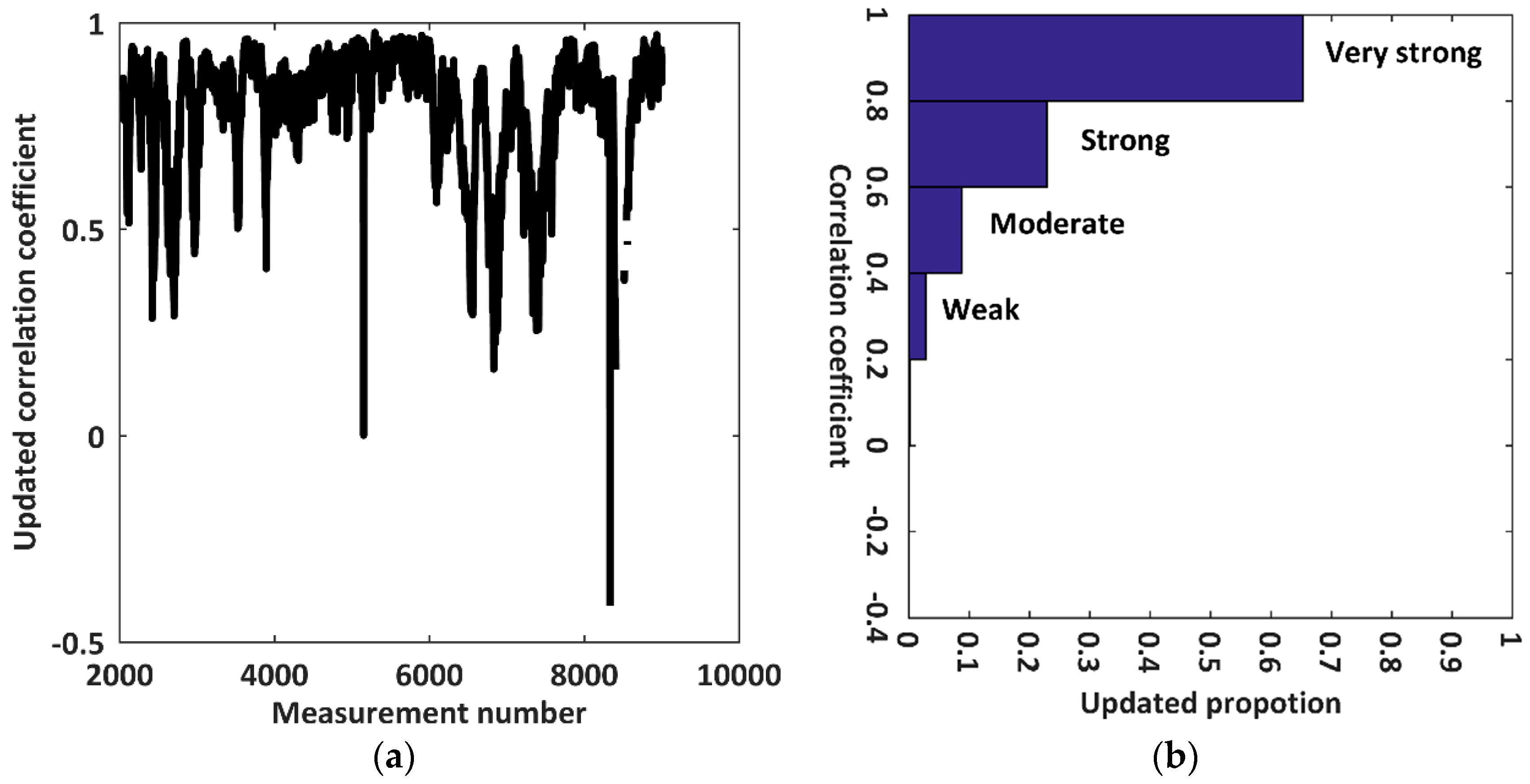
| Weak and Negative | Very Weak and Negative | Very Weak and Positive | Weak and Positive | Moderate and Positive | Strong and Positive | Very Strong and Positive |
|---|---|---|---|---|---|---|
| 1.29% | 1.74% | 6.01% | 16.37% | 30.53% | 34.67% | 9.39% |
© 2018 by the authors. Licensee MDPI, Basel, Switzerland. This article is an open access article distributed under the terms and conditions of the Creative Commons Attribution (CC BY) license (http://creativecommons.org/licenses/by/4.0/).
Share and Cite
Zhou, H.; Chen, Y.; Feng, Z.; Li, F.; Hyyppä, J.; Hakala, T.; Karjalainen, M.; Jiang, C.; Pei, L. The Comparison of Canopy Height Profiles Extracted from Ku-band Profile Radar Waveforms and LiDAR Data. Remote Sens. 2018, 10, 701. https://doi.org/10.3390/rs10050701
Zhou H, Chen Y, Feng Z, Li F, Hyyppä J, Hakala T, Karjalainen M, Jiang C, Pei L. The Comparison of Canopy Height Profiles Extracted from Ku-band Profile Radar Waveforms and LiDAR Data. Remote Sensing. 2018; 10(5):701. https://doi.org/10.3390/rs10050701
Chicago/Turabian StyleZhou, Hui, Yuwei Chen, Ziyi Feng, Fashuai Li, Juha Hyyppä, Teemu Hakala, Mika Karjalainen, Changhui Jiang, and Ling Pei. 2018. "The Comparison of Canopy Height Profiles Extracted from Ku-band Profile Radar Waveforms and LiDAR Data" Remote Sensing 10, no. 5: 701. https://doi.org/10.3390/rs10050701
APA StyleZhou, H., Chen, Y., Feng, Z., Li, F., Hyyppä, J., Hakala, T., Karjalainen, M., Jiang, C., & Pei, L. (2018). The Comparison of Canopy Height Profiles Extracted from Ku-band Profile Radar Waveforms and LiDAR Data. Remote Sensing, 10(5), 701. https://doi.org/10.3390/rs10050701


