Real-Time Tropospheric Delay Retrieval from Multi-GNSS PPP Ambiguity Resolution: Validation with Final Troposphere Products and a Numerical Weather Model


Abstract
:
1. Introduction
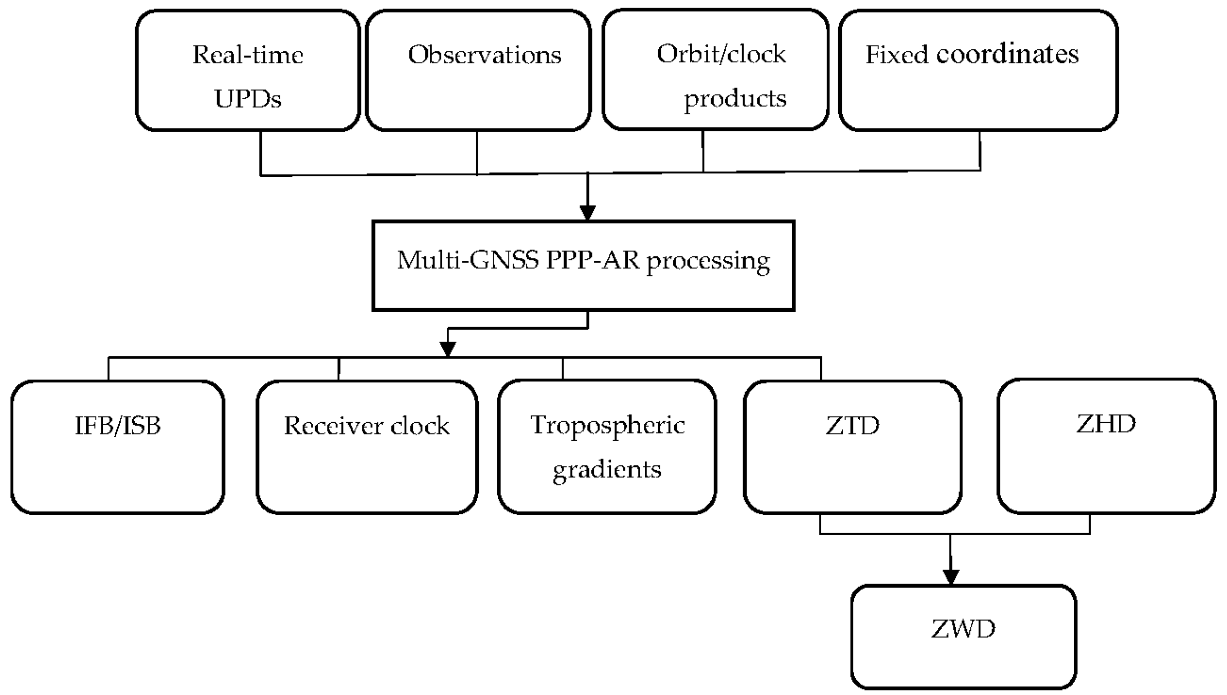
2. Real-Time Sensing of Tropospheric Delay from Multi-GNSS PPP-AR
3. Data Collection
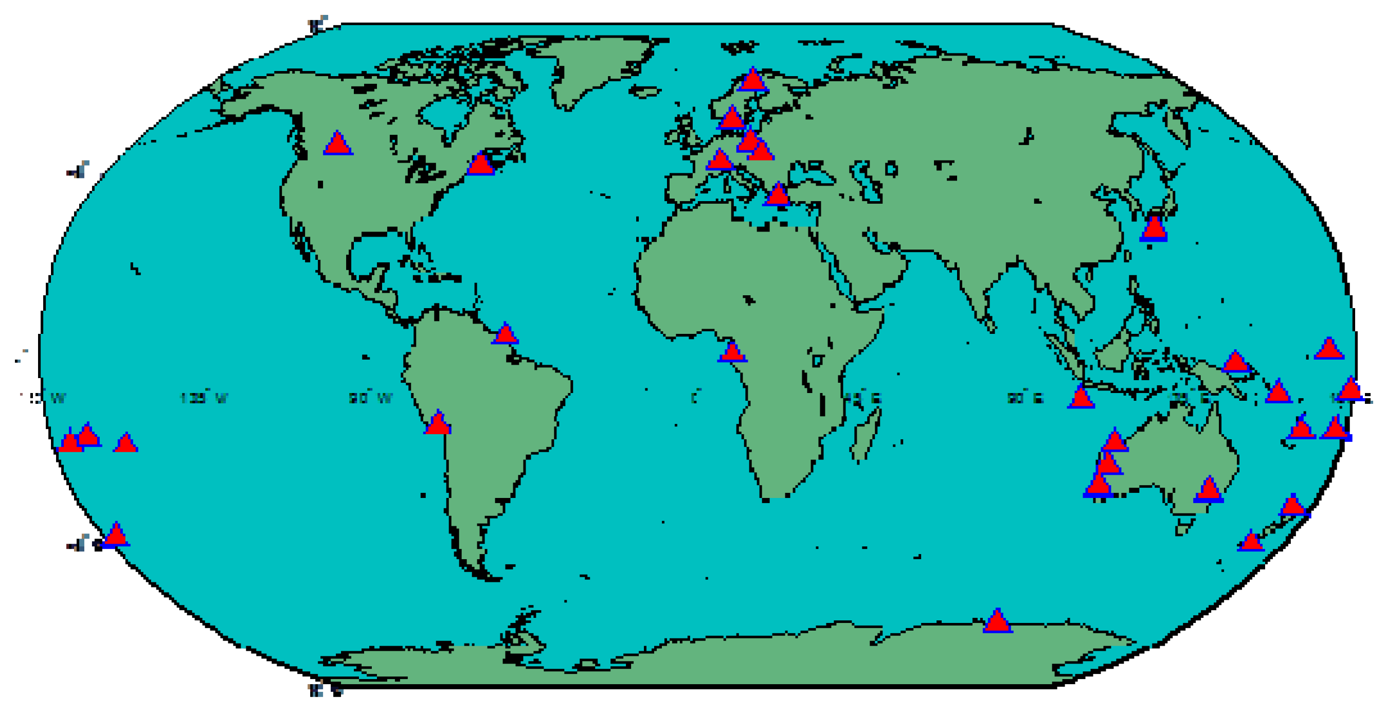
3.1. Multi-GNSS Data
3.2. Final Troposphere Products
3.3. ECMWF Data
4. Results and Validations
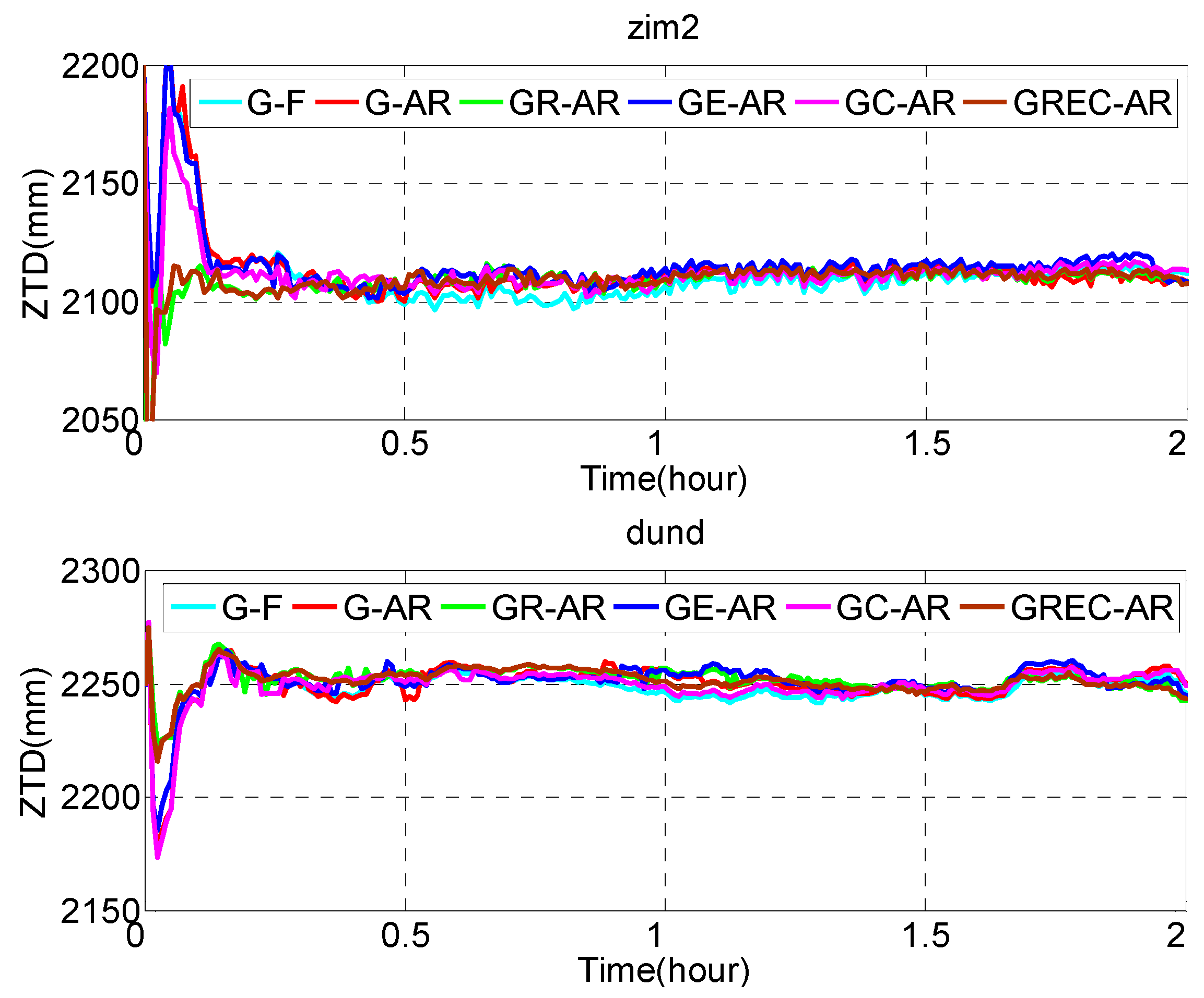
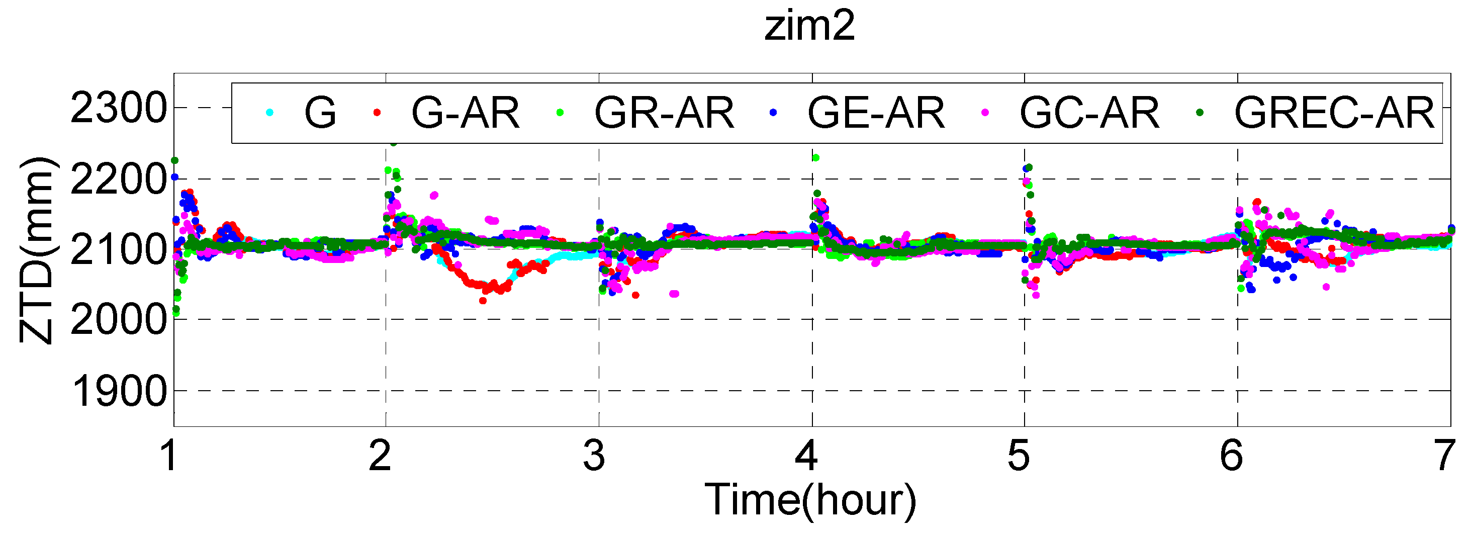
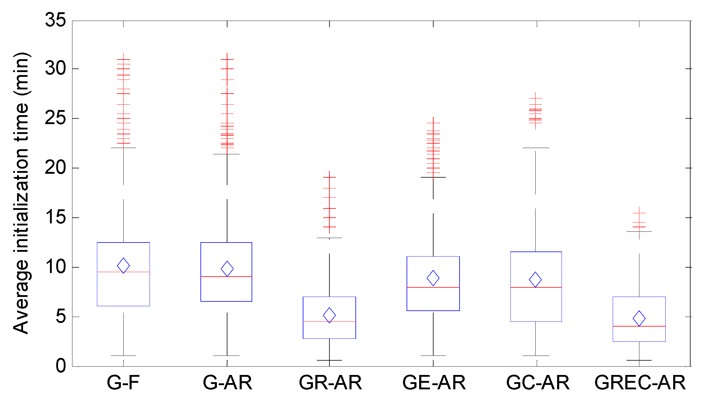
4.1. Initialization Analysis
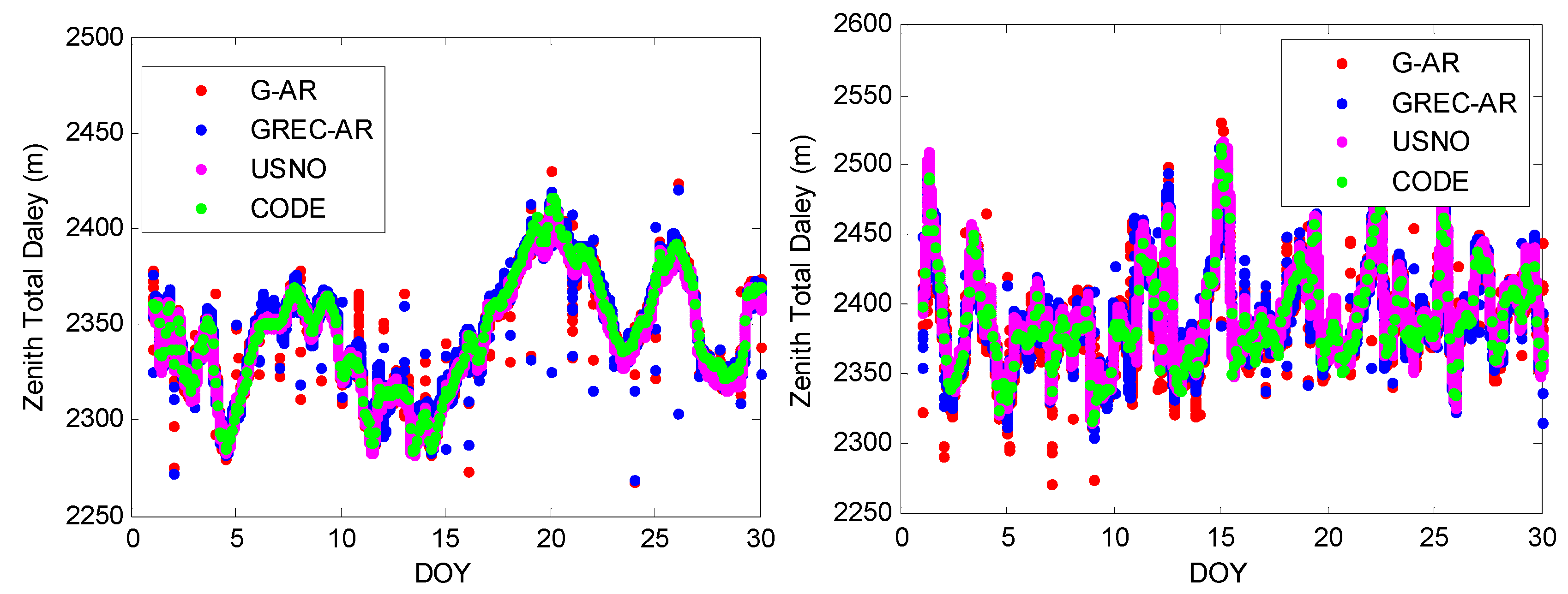
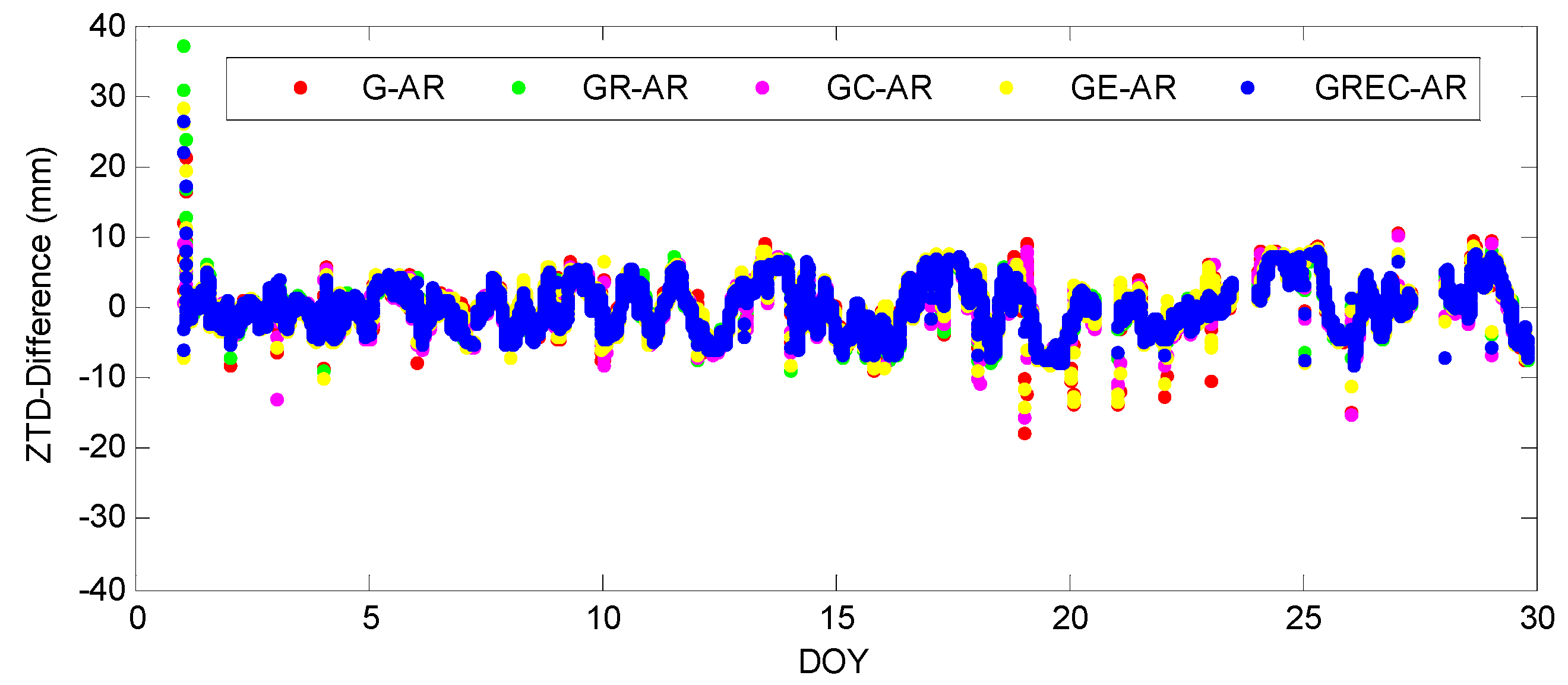
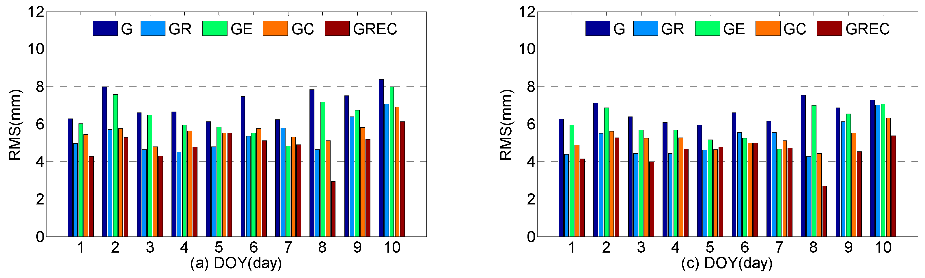
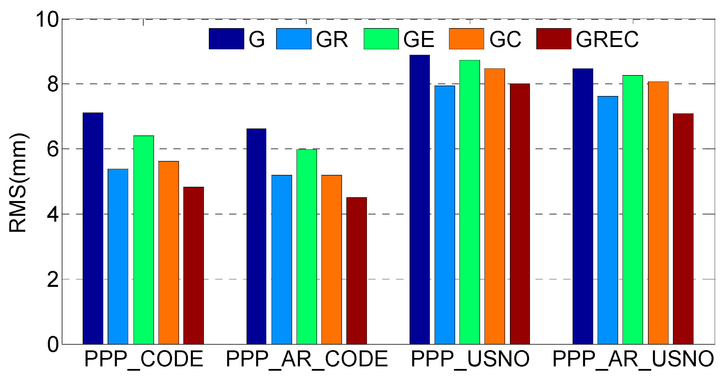
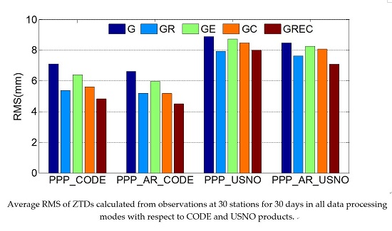
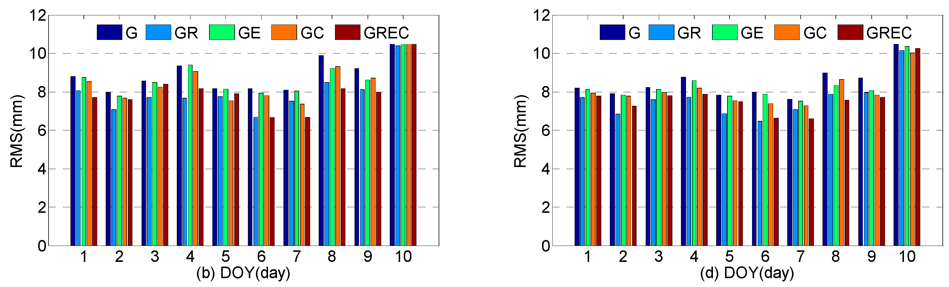
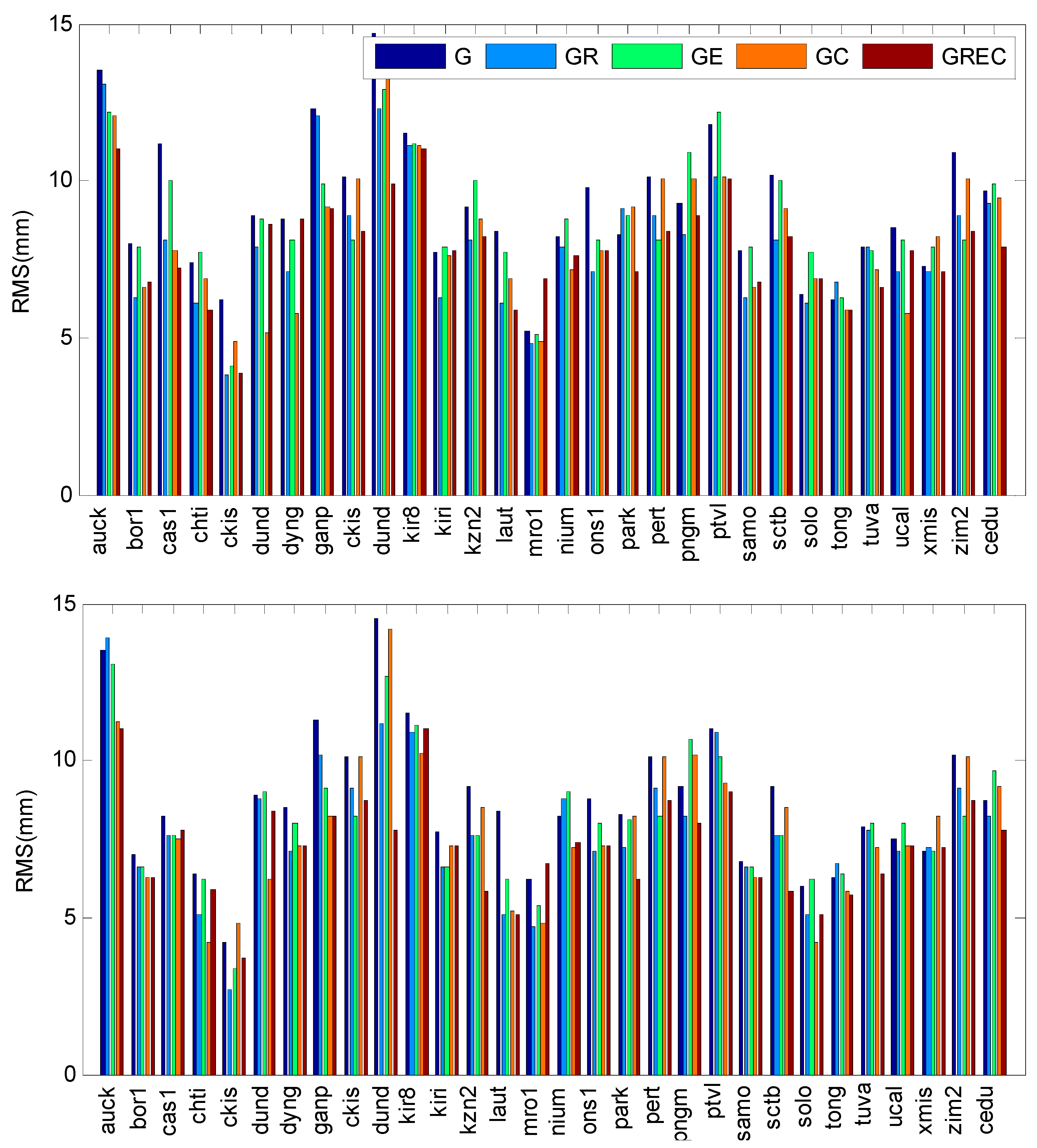
4.2. Accuracy Validation with Final Troposphere Products
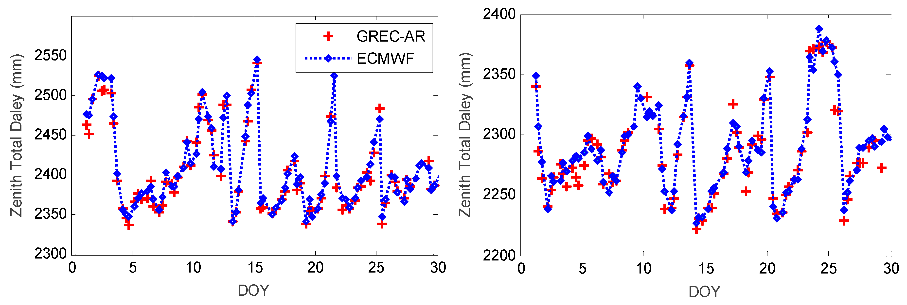
4.3. Accuracy Validation with ECMWF Data
5. Conclusions
Acknowledgments
Author Contributions
Conflicts of Interest
Abbreviations
| AR | Ambiguity Resolution |
| ACs | Analysis Centers |
| AR | Ambiguity Resolution |
| BDS | BeiDou Navigation Satellite System |
| CODE | Center for Orbit Determination |
| COST | Co-operation in the field of Scientific and Technical Research |
| DORIS | Delft object-oriented radar interferometric software |
| ECMWF | European Centre for Medium-Range Weather Forecasts |
| FDMA | Frequency Division Multiple Access |
| GNSS4SWEC | Advanced Global Navigation Satellite Systems tropospheric products for monitoring severe weather events and climate |
| GMF | Global Mapping Function |
| GNSS4SWEC | Advanced Global Navigation Satellite Systems tropospheric products for monitoring severe Weather Events and Climate |
| GIM | Global Ionosphere Maps |
| GLONASS | Global Orbiting Navigational Satellite System |
| GPT | Global Pressure and Temperature |
| GPS | Global Positioning System |
| HMW | Hatch-Melbourne-Wübbena |
| IF | Ionosphere-Free |
| IGSO | Inclined Geosynchronous Orbit |
| IGS | International GNSS Service |
| ISB | Inter-System Bias |
| IFB | Inter-Frequency Bias |
| multi-GNSS | multiple Global Navigation Satellite Systems |
| MGEX | Multi-GNSS Experiment |
| MEO | Medium Earth Orbit |
| NL | Narrow-Lane |
| PPP | Precise Point Positioning |
| PWV | Perceptible Water Vapor |
| RMS | Root Mean Square |
| USNO | U.S. Naval Observatory |
| VLBI | Very Long Baseline Interferometry |
| WL | Wide-Lane |
| ZTD | Zenith Tropospheric Delay |
| ZHD | Zenith Hydrostatic Delay |
| ZWD | Zenith Wet Delay |
References
- Bevis, M.; Businger, S.; Herring, T.A.; Rocken, C.; Anthes, R.A.; Ware, R.H. Gps meteorology-remote-sensing of atmospheric water-vapor using the global positioning system. J. Geophys. Res. Atmos. 1992, 97, 15787–15801. [Google Scholar] [CrossRef]
- Fang, P.; Bevis, M.; Bock, Y.; Gutman, S.; Wolfe, D. Gps meteorology: Reducing systematic errors in geodetic estimates for zenith delay. Geophys. Res. Lett. 1998, 25, 3583–3586. [Google Scholar] [CrossRef]
- Duan, J.P.; Bevis, M.; Fang, P.; Bock, Y.; Chiswell, S.; Businger, S.; Rocken, C.; Solheim, F.; van Hove, T.; Ware, R.; et al. Gps meteorology: Direct estimation of the absolute value of precipitable water. J. Appl. Meteorol. 1996, 35, 830–838. [Google Scholar] [CrossRef]
- Rocken, C.; Ware, R.; Vanhove, T.; Solheim, F.; Alber, C.; Johnson, J. Sensing atmospheric water-vapor with the global positioning system. Geophys. Res. Lett. 1993, 20, 2631–2634. [Google Scholar] [CrossRef]
- Jade, S.; Vijayan, M.S.M. Gps-based atmospheric precipitable water vapor estimation using meteorological parameters interpolated from ncep global reanalysis data. J. Geophys. Res. Atmos. 2008, 113. [Google Scholar] [CrossRef]
- Wang, X.M.; Zhang, K.F.; Wu, S.Q.; He, C.Y.; Cheng, Y.Y.; Li, X.X. Determination of zenith hydrostatic delay and its impact on gnss-derived integrated water vapor. Atmos. Meas. Technol. 2017, 10, 2807–2820. [Google Scholar] [CrossRef]
- Lu, C.X.; Chen, X.H.; Liu, G.; Dick, G.; Wickert, J.; Jiang, X.Y.; Zheng, K.; Schuh, H. Real-time tropospheric delays retrieved from multi-gnss observations and igs real-time product streams. Remote Sens. Basel 2017, 9, 1317. [Google Scholar] [CrossRef]
- Dong, Z.N.; Jin, S.G. 3-d water vapor tomography in wuhan from gps, bds and glonass observations. Remote Sens. Basel 2018, 10, 62. [Google Scholar] [CrossRef]
- Li, X.X.; Dick, G.; Ge, M.R.; Heise, S.; Wickert, J.; Bender, M. Real-time gps sensing of atmospheric water vapor: Precise point positioning with orbit, clock, and phase delay corrections. Geophys. Res. Lett. 2014, 41, 3615–3621. [Google Scholar] [CrossRef]
- Dick, G.; Gendt, G.; Reigber, C. First experience with near real-time water vapor estimation in a german gps network. J. Atmos. Sol. Terr. Phys. 2001, 63, 1295–1304. [Google Scholar] [CrossRef]
- Gendt, G.; Dick, G.; Reigber, C.; Tomassini, M.; Liu, Y.X.; Ramatschi, M. Near real time gps water vapor monitoring for numerical weather prediction in germany. J. Meteorol. Soc. Jpn. 2004, 82, 361–370. [Google Scholar] [CrossRef]
- Rocken, C.; Van Hove, T.; Ware, R. Near real-time GPS sensing of atmospheric water vapor. Geophys. Res. Lett. 1997, 24, 3221–3224. [Google Scholar] [CrossRef]
- Karabatic, A.; Weber, R.; Haiden, T. Near real-time estimation of tropospheric water vapour content from ground based gnss data and its potential contribution to weather now-casting in austria. Adv. Space Res. 2011, 47, 1691–1703. [Google Scholar] [CrossRef]
- Nilsson, T.; Elgered, G. Long-term trends in the atmospheric water vapor content estimated from ground-based gps data. J. Geophys. Res. Atmos. 2008, 113. [Google Scholar] [CrossRef]
- Dousa, J.; Vaclavovic, P. Real-time zenith tropospheric delays in support of numerical weather prediction applications. Adv. Space Res. 2014, 53, 1347–1358. [Google Scholar] [CrossRef]
- Shoji, Y.; Kunii, M.; Saito, K. Mesoscale data assimilation of myanmar cyclone nargis part ii: Assimilation of gps-derived precipitable water vapor. J. Meteorol. Soc. Jpn. 2011, 89, 67–88. [Google Scholar] [CrossRef]
- Dousa, J. Towards an operational near real-time precipitable water vapor estimation. Phys. Chem. Earth Part A 2001, 26, 189–194. [Google Scholar] [CrossRef]
- Mass, C. Nowcasting the promise of new technologies of communication, modeling, and observation. Bull. Am. Meteorol. Soc. 2012, 93, 797–809. [Google Scholar] [CrossRef]
- Yuan, Y.B.; Zhang, K.F.; Rohm, W.; Choy, S.; Norman, R.; Wang, C.S. Real-time retrieval of precipitable water vapor from gps precise point positioning. J. Geophys. Res. Atmos. 2014, 119, 10044–10057. [Google Scholar] [CrossRef]
- Zumberge, J.F.; Heflin, M.B.; Jefferson, D.C.; Watkins, M.M.; Webb, F.H. Precise point positioning for the efficient and robust analysis of gps data from large networks. J. Geophys. Res. Sol. Earth 1997, 102, 5005–5017. [Google Scholar] [CrossRef]
- Ge, M.; Gendt, G.; Rothacher, M.; Shi, C.; Liu, J. Resolution of gps carrier-phase ambiguities in precise point positioning (ppp) with daily observations. J. Geodesy 2008, 82, 389–399. [Google Scholar] [CrossRef]
- Laurichesse, D.; Mercier, F.; Berthias, J.P.; Bijac, J. Real time zero-difference ambiguities fixing and absolute rtk. In Proceedings of the 2008 National Technical Meeting of the Institute of Navigation-Ntm, San Diego, CA, USA, 28–30 January 2008; pp. 747–755. [Google Scholar]
- Odijk, D.; Zhang, B.; Khodabandeh, A.; Odolinski, R.; Teunissen, P.J.G. On the estimability of parameters in undifferenced, uncombined GNSS network and PPP-RTK user models by means of of S-system theory. J. Geodesy 2016, 90, 15–44. [Google Scholar] [CrossRef]
- Ahmed, F.; Václavovic, P.; Teferle, F.N.; Douša, J.; Bingley, R.; Laurichesse, D. Comparative analysis of real-time Precise Point Positioning zenith total delay estimates. GPS Solut. 2016, 20, 187–199. [Google Scholar] [CrossRef]
- Jones, J. Cost action es1206: Advanced global navigation satellite systems tropospheric products for monitoring severe weather events and climate (GNSS4SWEC). In Proceedings of the AGU Fall Meeting, San Francisco, CA, USA, 9–13 December 2013. [Google Scholar]
- Guerova, G.; Jones, J.; Dousa, J.; Dick, G.; de Haan, S.; Pottiaux, E.; Bock, O.; Pacione, R.; Elgered, G.; Vedel, H.; et al. Review of the state of the art and future prospects of the ground-based gnss meteorology in europe. Atmos. Meas. Technol. 2016, 9, 5385–5406. [Google Scholar] [CrossRef]
- Ding, W.W.; Teferle, F.N.; Kazmierski, K.; Laurichesse, D.; Yuan, Y.B. An evaluation of real-time troposphere estimation based on gnss precise point positioning. J. Geophys. Res. Atmos. 2017, 122, 2779–2790. [Google Scholar] [CrossRef]
- Li, X.X.; Zus, F.; Lu, C.X.; Dick, G.; Ning, T.; Ge, M.R.; Wickert, J.; Schuh, H. Retrieving of atmospheric parameters from multi-gnss in real time: Validation with water vapor radiometer and numerical weather model. J. Geophys. Res. Atmos. 2015, 120, 7189–7204. [Google Scholar] [CrossRef]
- Saastamoinen, J. Contributions to the theory of atmospheric refraction. Bull. Géodésique (1946–1975) 1973, 107, 13–34. [Google Scholar] [CrossRef]
- Li, X.X.; Ge, M.R.; Zhang, H.P.; Wickert, J. A method for improving uncalibrated phase delay estimation and ambiguity-fixing in real-time precise point positioning. J. Geodesy 2013, 87, 405–416. [Google Scholar] [CrossRef]
- Geng, J.; Teferle, F.N.; Meng, X.; Dodson, A.H. Towards ppp-rtk: Ambiguity resolution in real-time precise point positioning. Adv. Space Res. 2011, 47, 1664–1673. [Google Scholar] [CrossRef]
- Wübbena, G. Software developments for geodetic positioning with GPS using TI-4100 code and carrier measurements. In Proceedings of the First International Symposium on Precise Positioning with the Global Positioning System, Rockville, MD, USA, 15–19 April 1985. [Google Scholar]
- Melbourne, W. The case for ranging in GPS-based geodetic systems. In Proceedings of the First International Symposium on Precise Positioning with GPS, Rockville, MD, USA, 15–19 April 1985; pp. 373–386. [Google Scholar]
- Hatch, R. The synergism of GPS code and carrier measurements. In Proceedings of the International Geodetic Symposium on Satellite Doppler Positioning, Las Cruces, NM, USA, 8–12 February 1983; pp. 1213–1231. [Google Scholar]
- Dong, D.N.; Bock, Y. Global positioning system network analysis with phase ambiguity resolution applied to crustal deformation studies in california. J. Geophys. Res. Solid 1989, 94, 3949–3966. [Google Scholar] [CrossRef]
- Wanninger, L.; Beer, S. Beidou satellite-induced code pseudorange variations: Diagnosis and therapy. GPS Solut. 2015, 19, 639–648. [Google Scholar] [CrossRef]
- Teunissen, P.J.G.; Khodabandeh, A. Review and principles of PPP-RTK methods. J. Geodesy 2015, 86, 217–240. [Google Scholar]
- Gabor, M.J.; Nerem, R.S. GPS carrier phase AR using satellite single difference. In Proceedings of the ION GNSS 1999 Institute of Navigation, Nashville, TN, USA, 14–17 September 1999; pp. 1569–1578. [Google Scholar]
- Teunissen, P.J.G. The least-squares ambiguity decorrelation adjustment: A method for fast gps integer ambiguity estimation. J. Geodesy 1995, 70, 65–82. [Google Scholar] [CrossRef]
- Verhagen, S.; Teunissen, P.J.G. The ratio test for future GNSS ambiguity resolution. GPS Solut. 2013, 17, 535–548. [Google Scholar] [CrossRef]
- Boehm, J.; Niell, A.; Tregoning, P.; Schuh, H. Global mapping function (gmf): A new empirical mapping function based on numerical weather model data. Geophys. Res. Lett. 2006, 33. [Google Scholar] [CrossRef]
- Petit, G.; Luzum, B. IERS Conventions (2010); Bureau International Des Poids et Mesures Sevres (FRANCE): Pavillon de Breteuil, France, 2010. [Google Scholar]
- Dow, J.M.; Neilan, R.E.; Rizos, C. The international gnss service in a changing landscape of global navigation satellite systems. J. Geodesy 2009, 83, 191–198. [Google Scholar] [CrossRef]
- Montenbruck, O.; Steigenberger, P.; Khachikyan, R.; Weber, G.; Langley, R.; Mervart, L.; Hugentobler, U. IGS-MGEX: Preparing the ground for multi-constellation gnss science. Inside GNSS 2014, 9, 42–49. [Google Scholar]
- Nadarajah, N.; Teunissen, P.J.G.; Sleewaegen, J.M.; Montenbruck, O. The mixed-receiver beidou inter-satellite-type bias and its impact on rtk positioning. GPS Solut. 2015, 19, 357–368. [Google Scholar] [CrossRef]
- Byram, S.; Hackman, C. High-precision gnss orbit, clock and eop estimation at the united states naval observatory. In Proceedings of the IEEE Position Location and Navigation Symposium (PLANS), Myrtle Beach, SC, USA, 23–26 April 2012; pp. 659–663. [Google Scholar]
- Hadas, T.; Bosy, J. Igs rts precise orbits and clocks verification and quality degradation over time. GPS Solut. 2015, 19, 93–105. [Google Scholar] [CrossRef]
- Hobiger, T.; Ichikawa, R.; Takasu, T.; Koyama, Y.; Kondo, T. Ray-traced troposphere slant delays for precise point positioning. Earth Planets Space 2008, 60, E1–E4. [Google Scholar] [CrossRef]
- Zus, F.; Bender, M.; Deng, Z.; Dick, G.; Heise, S.; Shang-Guan, M.; Wickert, J. A methodology to compute gps slant total delays in a numerical weather model. Radio Sci. 2012, 47. [Google Scholar] [CrossRef]
- Lu, C.X.; Li, X.X.; Zus, F.; Heinkelmann, R.; Dick, G.; Ge, M.R.; Wickert, J.; Schuh, H. Improving beidou real-time precise point positioning with numerical weather models. J. Geodesy 2017, 91, 1019–1029. [Google Scholar] [CrossRef]


| Item | Processing Strategies |
|---|---|
| Estimator | Sequential least squares estimator |
| Observations | Observation from GPS/GLONASS/BDS/Galileo |
| Signals | GPS and GLONASS: L1/L2; BDS: B1/B2; Galileo: E1/E5a |
| Sampling rate | 30 s |
| Elevation cutoff | 7° |
| Weight for observations | Elevation-dependent weighting strategy. |
| Satellite orbit | Fixed |
| Satellite clock | Fixed |
| Zenith Tropospheric delay | Initial model + random walk model |
| Tropospheric gradients | Random walk model |
| Mapping function | Global Mapping Function (GMF) [41] |
| Phase-windup effect | Corrected |
| Receiver clock | Estimated, white noise |
| ISB and IFB | Estimated as constant, GPS as reference |
| Station displacement | Solid Earth tide, pole tide, ocean tide loading International Earth Rotation and Reference Systems Service (IERS) Convention 2010 [42] |
| Satellite antenna phase center | Corrected |
| Receiver antenna phase center | Corrected |
| Coordinates of stations | Fixed |
| Ambiguities | PPP ambiguity resolution is applied |
| Models | Details |
|---|---|
| G | Float PPP solution based on GPS-only |
| GR | Float PPP solution based on GPS/GLONASS |
| GE | Float PPP solution based on GPS/Galileo |
| GC | Float PPP solution based on GPS/BDS |
| GREC | Float PPP solution based on GPS/GLONASS/Galileo BDS |
| G-AR | Fixed PPP solution based on GPS-only |
| GR-AR | Fixed PPP solution based on GPS/GLONASS |
| GE-AR | Fixed PPP solution based on GPS/Galileo |
| GC-AR | Fixed PPP solution based on GPS/BDS |
| GREC-AR | Fixed PPP solution based on GPS/GLONASS/Galileo/BDS |
| Solutions | Average Initialization Time |
|---|---|
| G-F | 10.1 |
| G-AR | 9.8 |
| GR-AR | 5.1 |
| GE-AR | 9.1 |
| GC-AR | 8.9 |
| GREC-AR | 4.8 |
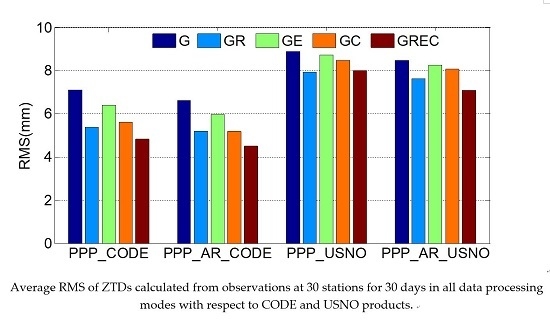
| System | PPP_CODE | PPP_AR_CODE | PPP_USNO | PPP_AR_USNO |
|---|---|---|---|---|
| G | 7.1 | 6.6 | 8.9 | 8.5 |
| GR | 5.3 | 5.2 | 7.9 | 7.6 |
| GE | 6.4 | 5.9 | 8.7 | 8.3 |
| GC | 5.6 | 5.2 | 8.5 | 8.1 |
| GREC | 4.8 | 4.5 | 8.0 | 7.1 |
| System | PPP | PPP_AR |
|---|---|---|
| G | 14.3 | 13.3 |
| GR | 13.6 | 12.6 |
| GE | 14.0 | 12.9 |
| GC | 13.7 | 12.7 |
| GREC | 13.2 | 12.5 |
© 2018 by the authors. Licensee MDPI, Basel, Switzerland. This article is an open access article distributed under the terms and conditions of the Creative Commons Attribution (CC BY) license (http://creativecommons.org/licenses/by/4.0/).
Share and Cite
Lu, C.; Li, X.; Cheng, J.; Dick, G.; Ge, M.; Wickert, J.; Schuh, H. Real-Time Tropospheric Delay Retrieval from Multi-GNSS PPP Ambiguity Resolution: Validation with Final Troposphere Products and a Numerical Weather Model. Remote Sens. 2018, 10, 481. https://doi.org/10.3390/rs10030481
Lu C, Li X, Cheng J, Dick G, Ge M, Wickert J, Schuh H. Real-Time Tropospheric Delay Retrieval from Multi-GNSS PPP Ambiguity Resolution: Validation with Final Troposphere Products and a Numerical Weather Model. Remote Sensing. 2018; 10(3):481. https://doi.org/10.3390/rs10030481
Chicago/Turabian StyleLu, Cuixian, Xin Li, Junlong Cheng, Galina Dick, Maorong Ge, Jens Wickert, and Harald Schuh. 2018. "Real-Time Tropospheric Delay Retrieval from Multi-GNSS PPP Ambiguity Resolution: Validation with Final Troposphere Products and a Numerical Weather Model" Remote Sensing 10, no. 3: 481. https://doi.org/10.3390/rs10030481
APA StyleLu, C., Li, X., Cheng, J., Dick, G., Ge, M., Wickert, J., & Schuh, H. (2018). Real-Time Tropospheric Delay Retrieval from Multi-GNSS PPP Ambiguity Resolution: Validation with Final Troposphere Products and a Numerical Weather Model. Remote Sensing, 10(3), 481. https://doi.org/10.3390/rs10030481