Fusion of Multi-Baseline and Multi-Orbit InSAR DEMs with Terrain Feature-Guided Filter


Abstract
:
1. Introduction
- (1)
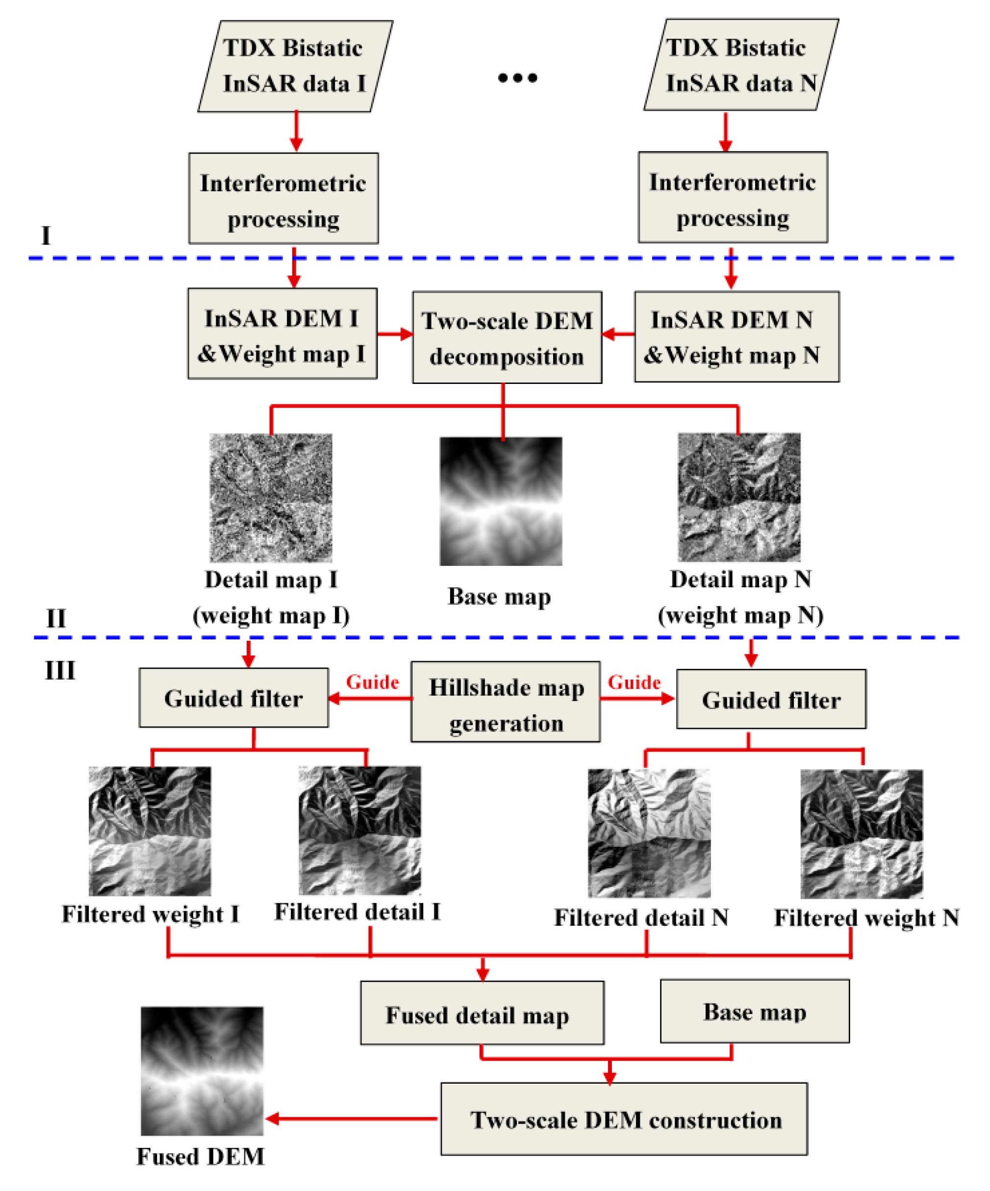
- A two-scale fusion strategy is adopted in the proposed fusion method to well preserve details. The two-scale representations of InSAR DEMs that are to be fused are realized with an average filter. The base layer aims to represent the large-scale variations of DEMs, which can model the overall trend of topography. Meanwhile, the detail layer tries to capture the remaining small-scale terrain details. Therefore, the algorithm can dedicate more attention to small-scale terrain cues to preserve details in the fusion process.
- (2)
- The proposed novel fusion method can introduce local spatial constraint information and can therefore smooth noise and fill data voids inside the search windows. If a pixel is located in a neighborhood with severe local terrain changes, its local variance increases. Guided filter preserves abrupt terrain changes by maintaining gradient consistency. Therefore, the proposed fusion method based on guided filter can well preserve the terrain details of the InSAR DEMs. Moreover, the fusion algorithm is also computationally efficient, considering the linear time complexity of guided filter.
- (3)
- The proposed fusion method takes the topographic features into consideration. The hillshade map is generated from the DEM data and can present topographic features such as ridges and the geometric outline of ground targets more explicitly. The hillshade map is performed as the guidance image in guided filter algorithm. Therefore, the novel weights of fusion after guided filter can integrate terrain feature information.
2. Methodology
2.1. InSAR DEM Generation and Theoretical Error Analysis
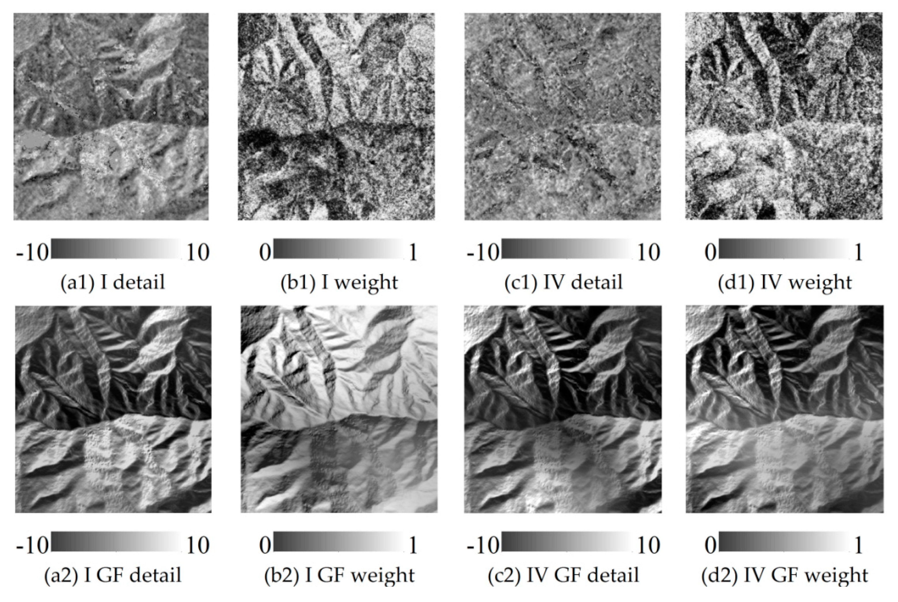
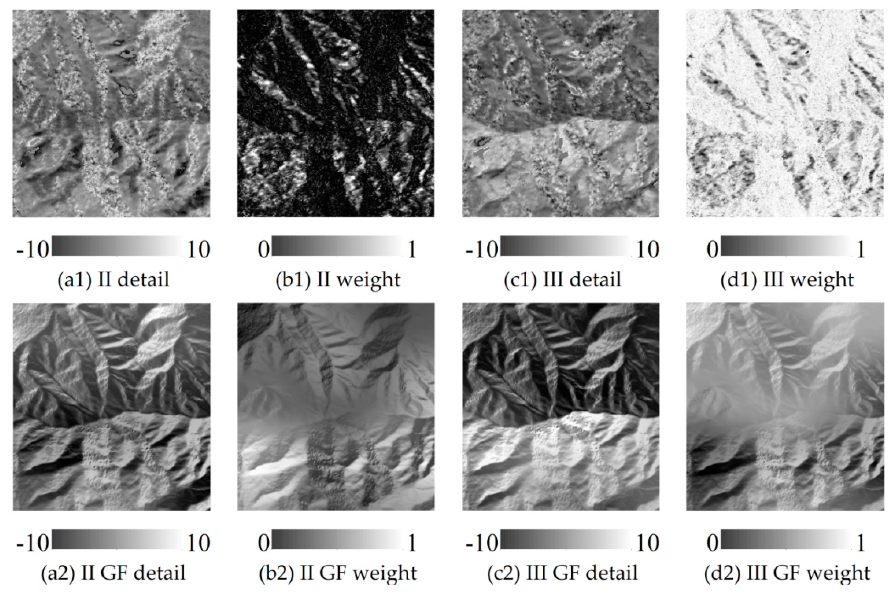
2.2. InSAR DEM Decomposition and Hillsade Map Generation
2.3. InSAR DEM Fusion with Guided Filter
3. Results
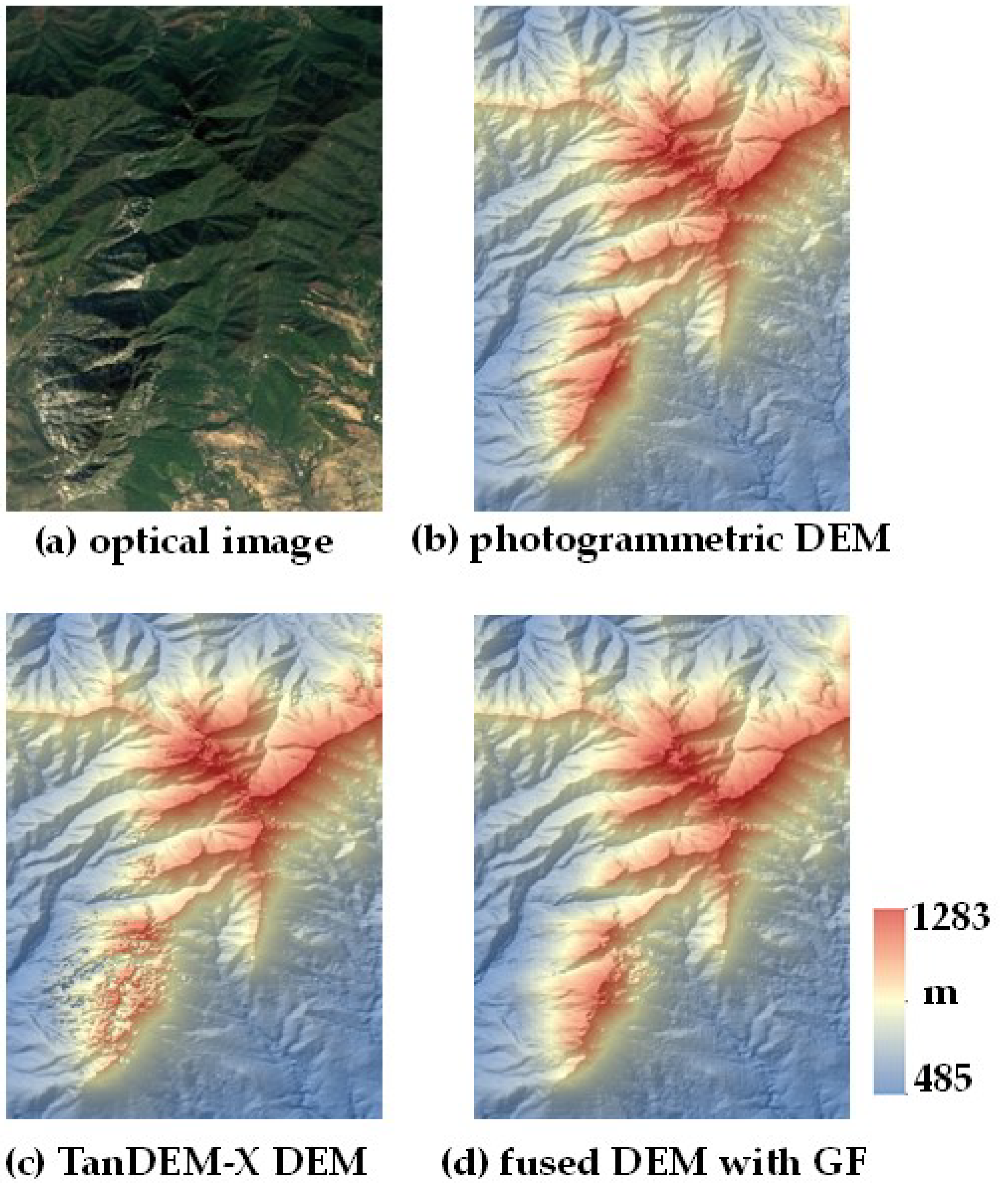
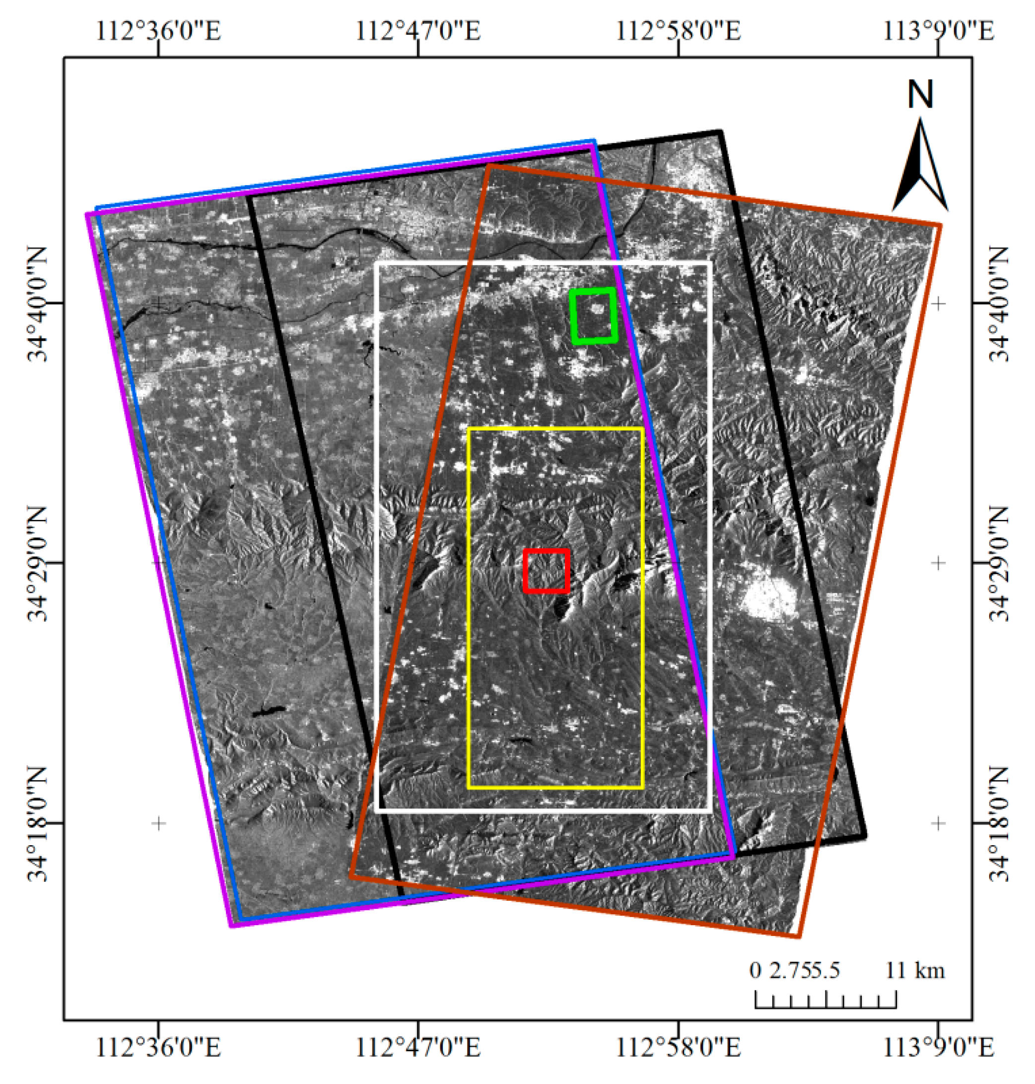
3.1. Experimental Area and Data
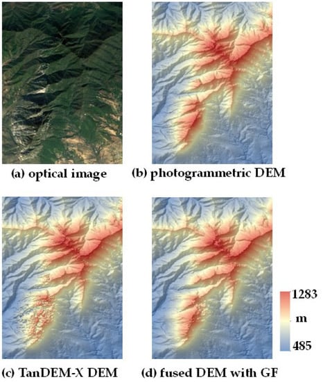
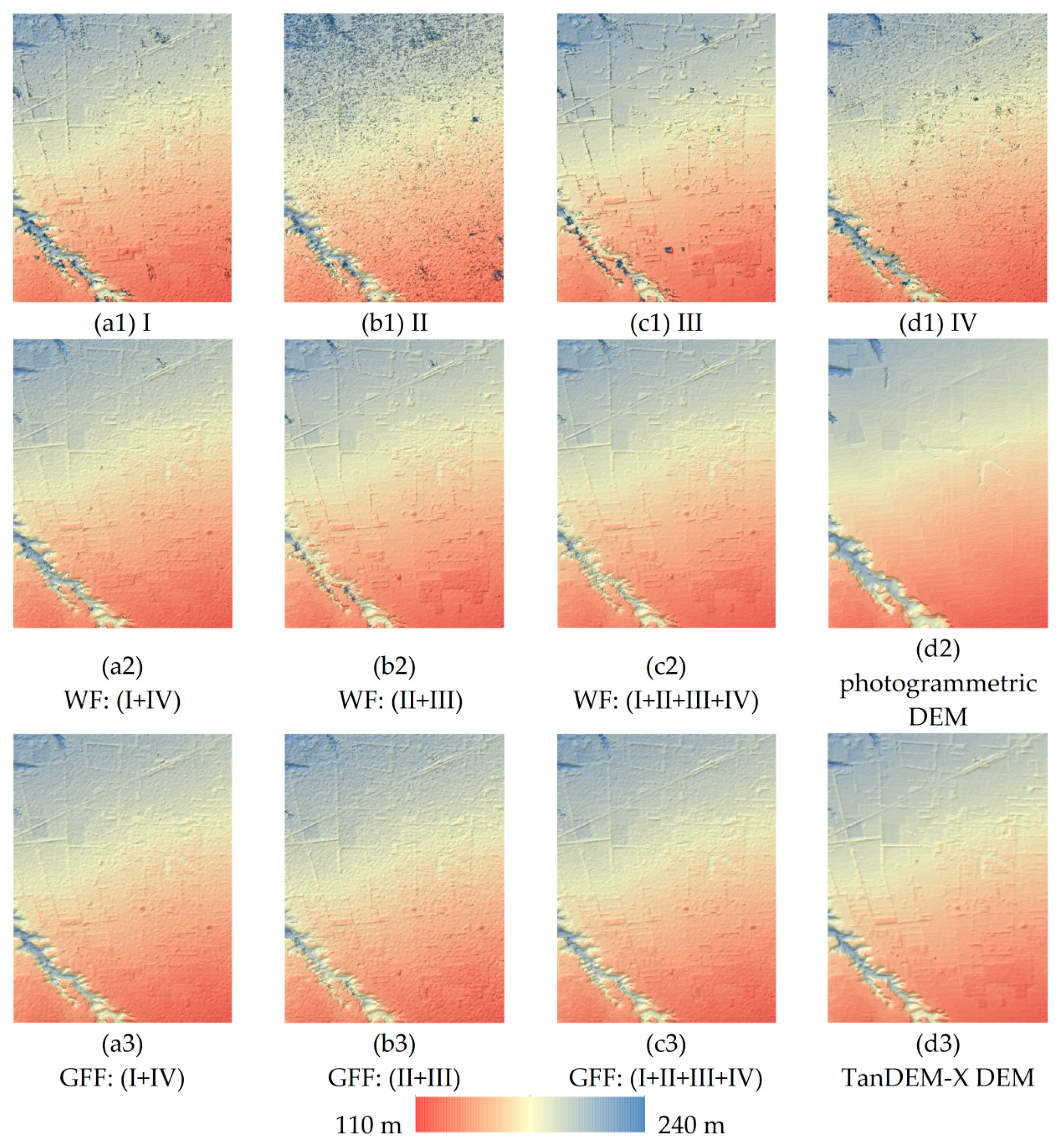
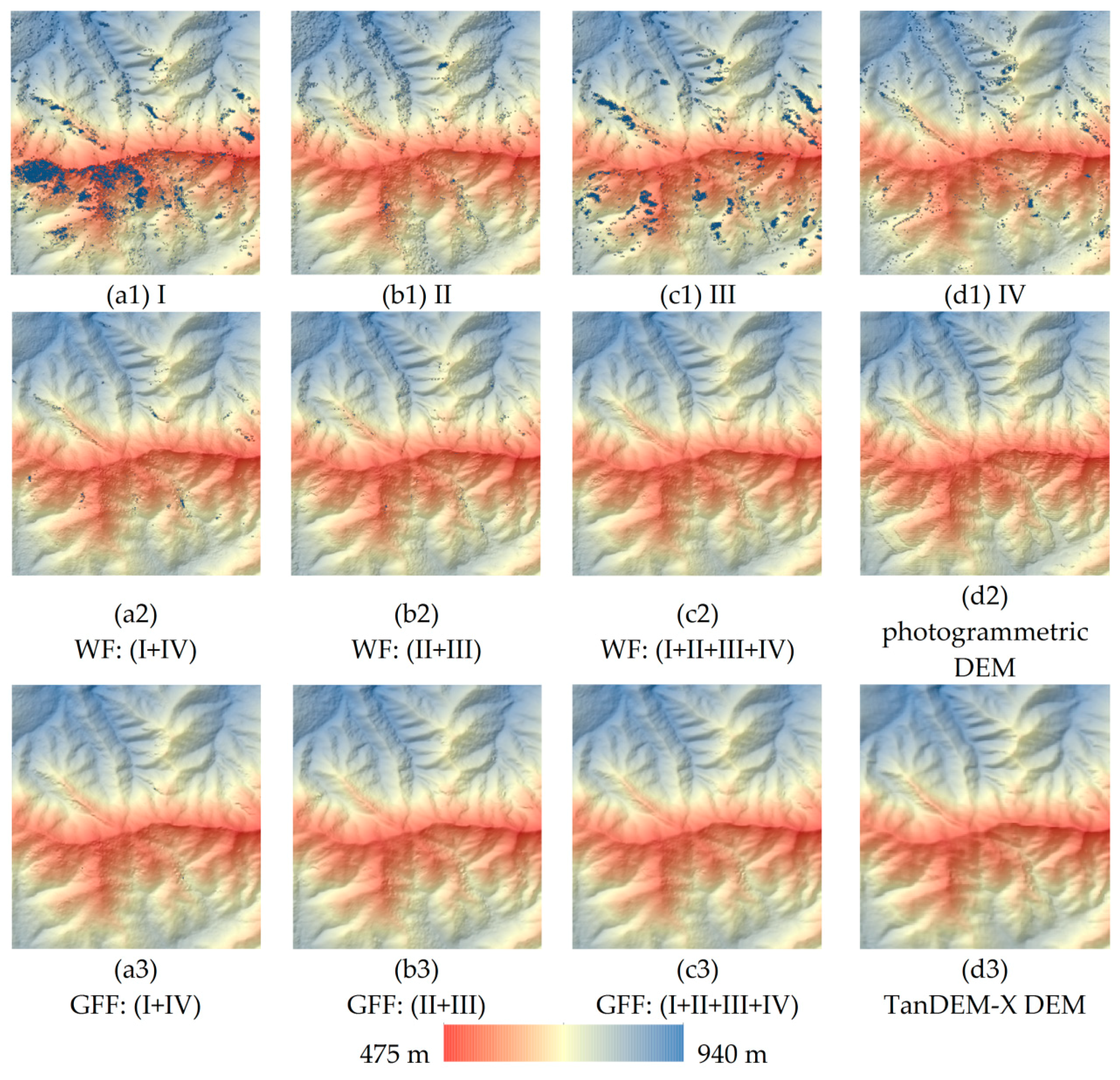
3.2. Experimental Results for InSAR DEM Fusion
4. Discussion
4.1. Comparative Analysis of the Single-Baseline InSAR DEMs and the Fused InSAR DEMs
4.2. Comparative Analysis of the Fused DEMs with Weighted Average and Guided Filters
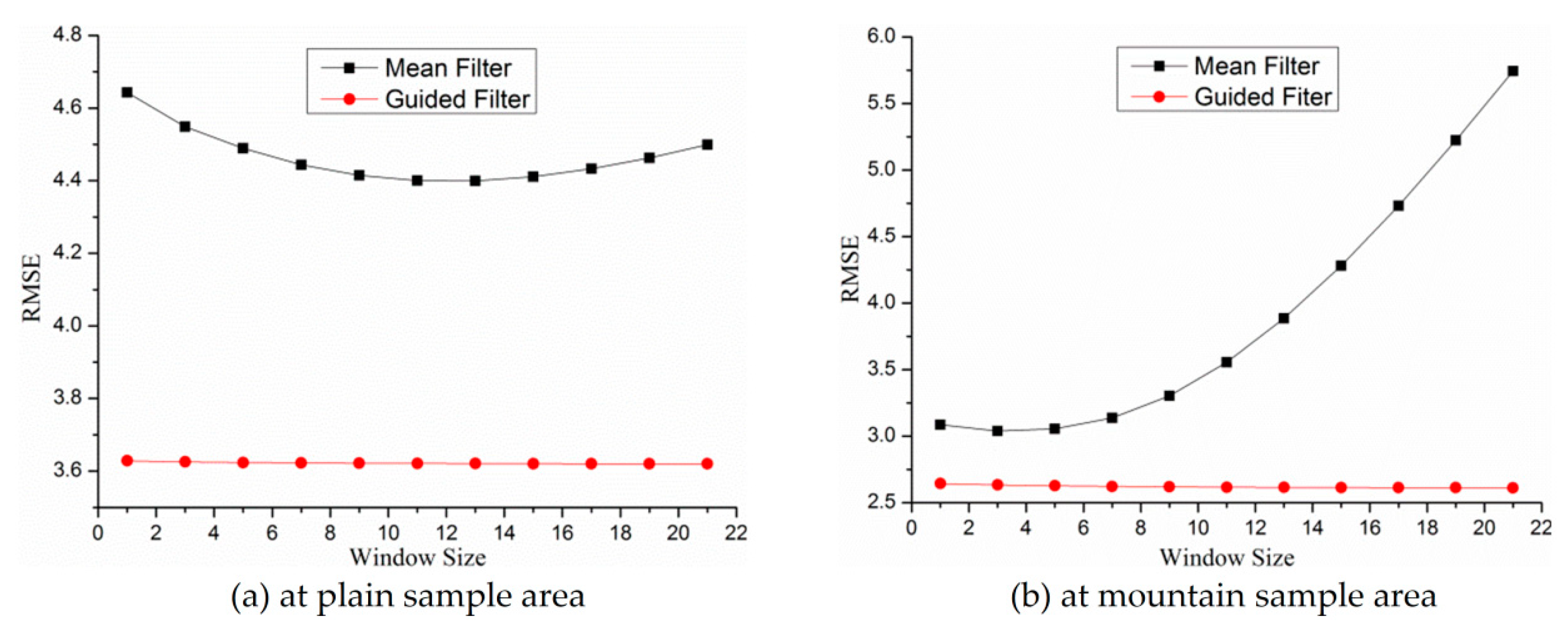
4.3. Comparative Analysis of the Guided Filter and the Mean Filter
5. Conclusions
- (1)
- The fusion of multi-baseline and multi-orbit InSAR DEMs can simultaneously solve the two major problems of single-baseline InSAR, namely the contradiction between height measurement sensitivity and phase unwrapping reliability caused by baseline length and the DEM data voids caused by layover or shadow effects. This technique maintains the advantage of higher height measurement sensitivity of long baselines while reducing the random height noise by increasing the number of observations. Furthermore, the fusion of ascending and descending InSAR DEMs can compensate for the data voids caused by geometric distortions.
- (2)
- The guided-filter-based InSAR DEM fusion method can take local spatial context information into consideration, which can help smooth the “salt-and-pepper” noise of InSAR DEMs and eliminate the abnormal height value. Furthermore, due to the spatial dependence of the height information, the guided-filter-based InSAR DEM fusion method can fill in almost all the data voids.
- (3)
- The guided-filter-based InSAR DEM fusion method can well preserve the terrain details. The two-scale fusion strategy can help retain the high-frequency detail information. Furthermore, the guided filter belongs to the category of edge-preserving smoothing filters, and the fused InSAR DEM obtained using guided filter can well preserve the terrain features with the DEM hillshade image as the guidance image.
- (4)
- The fused InSAR DEM with guided filter has smaller RMSE than the fused InSAR DEM with weighted average filter and the TanDEM-X DEM, which well validates the effectiveness of the proposed InSAR DEM fusion method with guided filter.
Author Contributions
Funding
Acknowledgments
Conflicts of Interest
References
- Jiang, H.; Zhang, L.; Wang, Y.; Liao, M. Fusion of high-resolution DEMs derived from COSMO-SkyMed and TerraSAR-X InSAR datasets. J. Geod. 2014, 88, 587–599. [Google Scholar] [CrossRef]
- Zebker, H.A.; Goldstein, R.M. Topographic mapping from interferometric synthetic aperture radar observations. J. Geophys. Res.-Solid Earth 1986, 91, 4993–4999. [Google Scholar] [CrossRef]
- Zebker, H.A.; Werner, C.L.; Rosen, P.A.; Hensley, S. Accuracy of topographic maps derived from ERS-1 interferometric radar. IEEE Trans. Geosci. Remote Sens. 1994, 32, 823–836. [Google Scholar] [CrossRef] [Green Version]
- Rosen, P.A.; Hensley, S.; Joughin, I.R.; Li, F.K.; Madsen, S.N.; Rodriguez, E.; Goldstein, R.M. Synthetic aperture radar interferometry. Proc. IEEE 2000, 88, 333–382. [Google Scholar] [CrossRef] [Green Version]
- Rabus, B.; Eineder, M.; Roth, A.; Bamler, R. The shuttle radar topography mission—A new class of digital elevation models acquired by spaceborne radar. ISPRS J. Photogramm. Remote Sens. 2003, 57, 241–262. [Google Scholar] [CrossRef]
- Becek, K. Assessing Global Digital Elevation Models Using the Runway Method: The Advanced Spaceborne Thermal Emission and Reflection Radiometer Versus the Shuttle Radar Topography Mission Case. IEEE Trans. Geosci. Remote Sens. 2014, 52, 4823–4831. [Google Scholar] [CrossRef]
- Farr, T.G.; Rosen, P.A.; Caro, E.; Crippen, R.; Duren, R.; Hensley, S.; Kobrick, M.; Paller, M.; Rodriguez, E.; Roth, L. The shuttle radar topography mission. Rev. Geophys. 2007, 45, RG2004. [Google Scholar] [CrossRef]
- Krieger, G.; Moreira, A.; Fiedler, H.; Hajnsek, I.; Werner, M.; Younis, M.; Zink, M. TanDEM-X: A satellite formation for high-resolution SAR interferometry. IEEE Trans. Geosci. Remote Sens. 2007, 45, 3317–3341. [Google Scholar] [CrossRef] [Green Version]
- Fritz, T.; Rossi, C.; Yague-Martinez, N.; Rodriguez-Gonzalez, F.; Lachaise, M.; Breit, H. Interferometric processing of TanDEM-X data. In Proceedings of the 2011 IEEE International Geoscience and Remote Sensing Symposium (IGARSS), Vancouver, BC, Canada, 24–29 July 2011. [Google Scholar]
- Rizzoli, P.; Martone, M.; Gonzalez, C.; Wecklich, C.; Tridon, D.B.; Bräutigam, B.; Bachmann, M.; Schulze, D.; Fritz, T.; Huber, M. Generation and performance assessment of the global TanDEM-X digital elevation model. ISPRS J. Photogramm. Remote Sens. 2017, 132, 119–139. [Google Scholar] [CrossRef]
- Krieger, G.; Zink, M.; Bachmann, M.; Braeutigam, B.; Schulze, D.; Martone, M.; Rizzoli, P.; Steinbrecher, U.; Antony, J.W.; De Zan, F.; et al. TanDEM-X: A radar interferometer with two formation-flying satellites. Acta Astronaut. 2013, 89, 83–98. [Google Scholar] [CrossRef]
- Thompson, D.G.; Robertson, A.E.; Arnold, D.V.; Long, D.G. Multi-baseline interferometric SAR for iterative height estimation. In Proceedings of the 1999 IEEE International Geoscience and Remote Sensing Symposium, Hamburg, Germany, 28 June–2 July 1999. [Google Scholar]
- Pascazio, V.; Schirinzi, G. Multifrequency InSAR height reconstruction through maximum likelihood estimation of local planes parameters. IEEE Trans. Image Process. 2002, 11, 1478–1489. [Google Scholar] [CrossRef] [PubMed]
- Eineder, M.; Adam, N. A maximum-likelihood estimator to simultaneously unwrap, geocode, and fuse SAR interferograms from different viewing geometries into one digital elevation model. IEEE Trans. Geosci. Remote Sens. 2005, 43, 24–36. [Google Scholar] [CrossRef]
- Fornaro, G.; Guarnieri, A.M.; Pauciullo, A.; De-Zan, F. Maximum likelihood multi-baseline SAR interferometry. IEE Proc.-Radar Sonar Navig. 2006, 153, 279–288. [Google Scholar] [CrossRef]
- Dong, Y.; Jiang, H.; Zhang, L.; Liao, M. An Efficient Maximum Likelihood Estimation Approach of Multi-Baseline SAR Interferometry for Refined Topographic Mapping in Mountainous Areas. Remote Sens. 2018, 10, 454. [Google Scholar] [CrossRef]
- Xia, X.-G.; Wang, G. Phase unwrapping and a robust Chinese remainder theorem. IEEE Signal Process. Lett. 2007, 14, 247–250. [Google Scholar] [CrossRef]
- Ghiglia, D.C.; Wahl, D.E. Interferometric synthetic aperture radar terrain elevation mapping from multiple observations. In Proceedings of the IEEE 6th Digital Signal Processing Workshop, Yosemite National Park, CA, USA, 2–5 October 1994. [Google Scholar]
- Ferraiuolo, G.; Pascazio, V.; Schirinzi, G. Maximum a posteriori estimation of height profiles in InSAR imaging. IEEE Geosci. Remote Sens. Lett. 2004, 1, 66–70. [Google Scholar] [CrossRef]
- Ferretti, A.; Prati, C.; Rocca, F. Multibaseline InSAR DEM reconstruction: The wavelet approach. IEEE Trans. Geosci. Remote Sens. 1999, 37, 705–715. [Google Scholar] [CrossRef]
- Deo, R.; Rossi, C.; Eineder, M.; Fritz, T.; Rao, Y.S. Framework for Fusion of Ascending and Descending Pass TanDEM-X Raw DEMs. IEEE J. Sel. Topics Appl. Earth Observ. Remote Sens. 2015, 8, 3347–3355. [Google Scholar] [CrossRef]
- Gruber, A.; Wessel, B.; Martone, M.; Roth, A. The TanDEM-X DEM Mosaicking: Fusion of Multiple Acquisitions Using InSAR Quality Parameters. IEEE J. Sel. Topics Appl. Earth Observ. Remote Sens. 2016, 9, 1047–1057. [Google Scholar] [CrossRef]
- Shen, R.; Cheng, I.; Shi, J.; Basu, A. Generalized Random Walks for Fusion of Multi-Exposure Images. IEEE Trans. Image Process. 2011, 20, 3634–3646. [Google Scholar] [CrossRef] [PubMed]
- Li, S.Z. Markov random field models in computer vision. In Proceedings of the European Conference on Computer Vision, Stockholm, Sweden, 2–6 May 1994. [Google Scholar]
- Li, S.; Kang, X.; Hu, J. Image Fusion with Guided Filtering. IEEE Trans. Image Process. 2013, 22, 2864–2875. [Google Scholar] [PubMed]
- Ferretti, A.; Prati, C.; Rocca, F. Multibaseline phase unwrapping for InSAR topography estimation. Nuovo Cimento Della Soc. Ital. Fis. C 2001, 24, 159–176. [Google Scholar]
- Hanssen, R.F. Radar Interferometry: Data Interpretation and Error Analysis; Springer Science & Business Media: Berlin, Germany, 2001. [Google Scholar]
- Goldstein, R.M.; Werner, C.L. Radar interferogram filtering for geophysical applications. Geophys. Res. Lett. 1998, 25, 4035–4038. [Google Scholar] [CrossRef] [Green Version]
- Baran, I.; Stewart, M.; Lilly, P. A modification to the Goldstein radar interferogram filter. IEEE Trans. Geosci. Remote Sens. 2003, 41, 2114–2118. [Google Scholar] [CrossRef]
- Goldstein, R.M.; Zebker, H.A.; Werner, C.L. Satellite radar interferometry: Two-dimensional phase unwrapping. Radio Sci. 1988, 23, 713–720. [Google Scholar] [CrossRef]
- Costantini, M. A novel phase unwrapping method based on network programming. IEEE Trans. Geosci. Remote Sens. 1998, 36, 813–821. [Google Scholar] [CrossRef]
- Chen, C.W.; Zebker, H.A. Two-dimensional phase unwrapping with use of statistical models for cost functions in nonlinear optimization. JOSA A 2001, 18, 338–351. [Google Scholar] [CrossRef] [PubMed]
- Liao, M.; Jiang, H.; Wang, Y.; Wang, T.; Zhang, L. Improved topographic mapping through high-resolution SAR interferometry with atmospheric effect removal. ISPRS J. Photogramm. Remote Sens. 2013, 80, 72–79. [Google Scholar] [CrossRef]
- Tough, J.; Balcknell, D.; Quegan, S. A statistical description of polarimetric and interferometric synthetic aperture radar data. Proc. R. Soc. Lond. A 1995, 449, 567–589. [Google Scholar] [CrossRef]
- Burrough, P.A.; McDonnell, R.; McDonnell, R.A.; Lloyd, C.D. Principles of Geographical Information Systems; Oxford University Press: Oxford, UK, 2015. [Google Scholar]
- He, K.; Sun, J.; Tang, X. Guided Image Filtering. IEEE Trans. Pattern Anal. Mach. Intell. 2013, 35, 1397–1409. [Google Scholar] [CrossRef] [PubMed]
- Friedman, J.; Hastie, T.; Tibshirani, R. The Elements of Statistical Learning; Series in statistics; Springer: New York, NY, USA, 2001; Volume 1. [Google Scholar]
- Draper, N.R.; Smith, H. Applied Regression Analysis; John Wiley and Sons: New York, USA, 2014. [Google Scholar]
- Rizzoli, P.; Bräutigam, B.; Kraus, T.; Martone, M.; Krieger, G. Relative height error analysis of TanDEM-X elevation data. ISPRS J. Photogramm. Remote Sens. 2012, 73, 30–38. [Google Scholar] [CrossRef] [Green Version]
- Wecklich, C.; Gonzalez, C.; Braeutigam, B.; Rizzoli, P. Height Accuracy and Data Coverage Status of the Global TanDEM-X DEM. In Proceedings of the 11th European Conference on Synthetic Aperture Radar (EUSAR 2016), Hamburg, Germany, 6–9 June 2016. [Google Scholar]
- Wessel, B. TanDEM-X Ground Segment–DEM Products Specification Document; Technique Note 3.1; Ger. Aerosp. Center (DLR): Wessling, Germany, 2016. [Google Scholar]
- Becek, K.; Koppe, W.; Kutoğlu, Ş. Evaluation of Vertical Accuracy of the WorldDEM™ Using the Runway Method. Remote Sens. 2016, 8, 934. [Google Scholar] [CrossRef]


| Interferogram I | Interferogram II | Interferogram III | Interferogram IV | |
|---|---|---|---|---|
| Acquisition time | 19 October 2011 | 26 January 2012 | 20 July 2012 | 25 January 2014 |
| Orbit direction | Ascending | Ascending | Ascending | Descending |
| Imaging mode | Stripmap | Stripmap | Stripmap | Stripmap |
| Polarization | HH | HH | HH | HH |
| Normal baseline | 251 m | 157 m | 471 m | 237 m |
| Height ambiguity | 30 m | 48 m | 16 m | 34 m |
| Central incidence angle | 44.4° | 44.4° | 45.0° | 46.7° |
| Mean coherence coefficient | 0.82 | 0.75 | 0.73 | 0.84 |
| All | Plain | Mountain | ||||||||
|---|---|---|---|---|---|---|---|---|---|---|
| Mean | RMSE | 90% LE | Mean | RMSE | 90% LE | Mean | RMSE | 90% LE | ||
| IV | m | 4.8 | 14.0 | 24.2 | 2.3 | 3.5 | 6.1 | −0.9 | 7.8 | 13.5 |
| III | m | 3.9 | 11.3 | 19.6 | 2.0 | 3.8 | 6.6 | −0.8 | 3.9 | 6.8 |
| II | m | 4.2 | 14.0 | 24.2 | 4.1 | 6.6 | 11.4 | 0.1 | 5.2 | 9.0 |
| I | m | 3.7 | 13.5 | 23.4 | 3.0 | 3.4 | 5.9 | 2.6 | 3.4 | 5.9 |
| I + IV | WF | 4.4 | 9.1 | 15.8 | 2.6 | 3.2 | 5.5 | 1.1 | 3.2 | 5.5 |
| GFF | 4.7 | 7.1 | 12.3 | 2.4 | 3.1 | 5.4 | 0.4 | 2.9 | 5.0 | |
| II + III | WF | 4.2 | 9.4 | 16.3 | 3.8 | 5.9 | 10.2 | −0.2 | 3.4 | 5.9 |
| GFF | 4.2 | 6.8 | 11.8 | 3.0 | 4.6 | 8.0 | −0.4 | 2.8 | 4.8 | |
| I + II + III + IV | WF | 4.3 | 7.2 | 12.5 | 3.4 | 4.6 | 8.0 | 0.4 | 3.1 | 5.4 |
| GFF | 4.4 | 6.7 | 11.6 | 2.8 | 3.7 | 6.4 | 0.3 | 2.6 | 4.5 | |
| TanDEM-X DEM | 1.6 | 14.1 | 24.4 | 1.6 | 3.5 | 6.1 | 0.3 | 3.1 | 5.4 | |
| All | Plain | Mountain | |||||
|---|---|---|---|---|---|---|---|
| Num. | Percentage | Num. | Percentage | Num. | Percentage | ||
| I | m | 378,026 | 2.04 | 4912 | 0.91 | 13518 | 5.81 |
| II | m | 291,784 | 1.58 | 12752 | 2.35 | 2220 | 0.95 |
| III | m | 395,605 | 2.14 | 4797 | 0.89 | 9010 | 3.87 |
| IV | m | 331,015 | 1.79 | 5094 | 0.94 | 3063 | 1.32 |
| I + IV | WF | 131,861 | 0.71 | 492 | 0.09 | 431 | 0.19 |
| GFF | 4997 | 0.03 | 62 | 0.01 | 54 | 0.02 | |
| II + III | WF | 128,201 | 0.69 | 732 | 0.14 | 251 | 0.11 |
| GFF | 4486 | 0.02 | 93 | 0.02 | 13 | 0.006 | |
| I + II + III + IV | WF | 48,253 | 0.26 | 72 | 0.01 | 8 | 0.003 |
| GFF | 3431 | 0.02 | 1 | 0 | 0 | 0 | |
© 2018 by the authors. Licensee MDPI, Basel, Switzerland. This article is an open access article distributed under the terms and conditions of the Creative Commons Attribution (CC BY) license (http://creativecommons.org/licenses/by/4.0/).
Share and Cite
Dong, Y.; Liu, B.; Zhang, L.; Liao, M.; Zhao, J. Fusion of Multi-Baseline and Multi-Orbit InSAR DEMs with Terrain Feature-Guided Filter. Remote Sens. 2018, 10, 1511. https://doi.org/10.3390/rs10101511
Dong Y, Liu B, Zhang L, Liao M, Zhao J. Fusion of Multi-Baseline and Multi-Orbit InSAR DEMs with Terrain Feature-Guided Filter. Remote Sensing. 2018; 10(10):1511. https://doi.org/10.3390/rs10101511
Chicago/Turabian StyleDong, Yuting, Baobao Liu, Lu Zhang, Mingsheng Liao, and Ji Zhao. 2018. "Fusion of Multi-Baseline and Multi-Orbit InSAR DEMs with Terrain Feature-Guided Filter" Remote Sensing 10, no. 10: 1511. https://doi.org/10.3390/rs10101511
APA StyleDong, Y., Liu, B., Zhang, L., Liao, M., & Zhao, J. (2018). Fusion of Multi-Baseline and Multi-Orbit InSAR DEMs with Terrain Feature-Guided Filter. Remote Sensing, 10(10), 1511. https://doi.org/10.3390/rs10101511