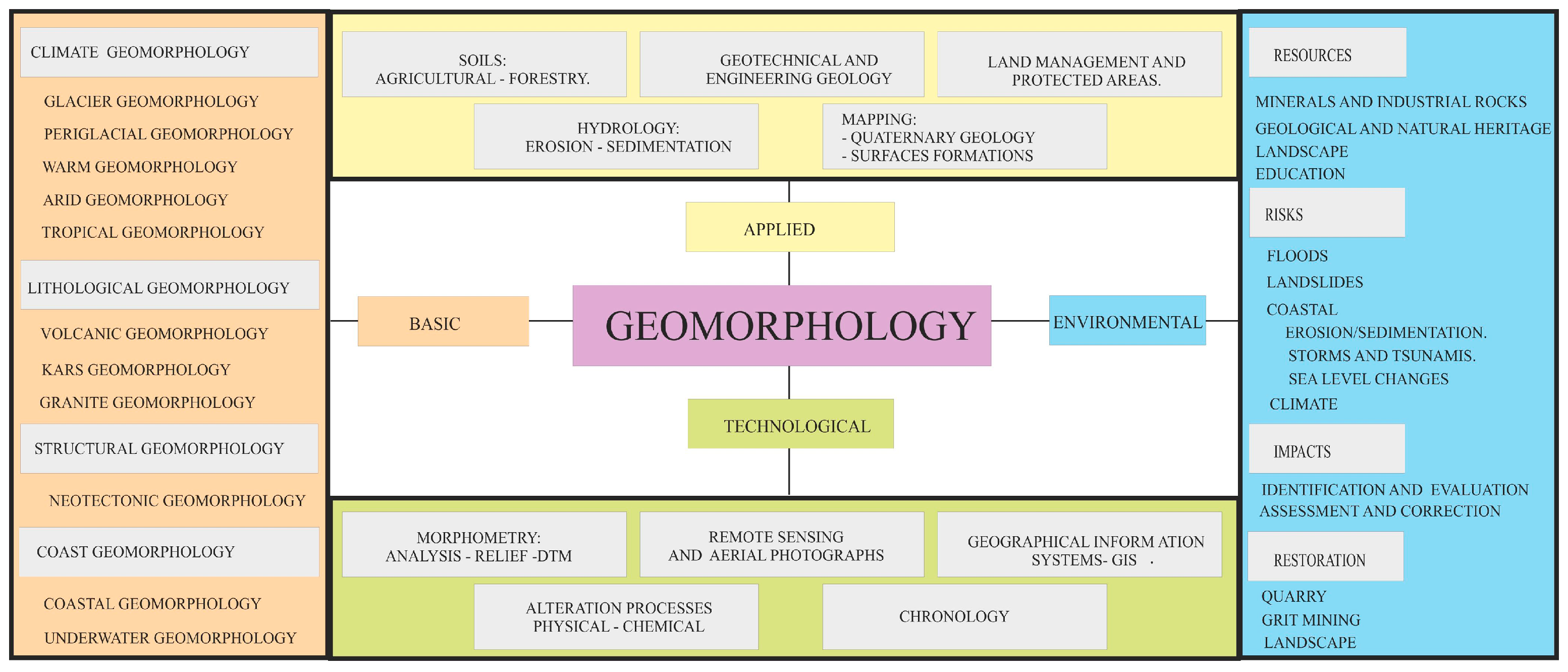
1. Introduction
Geomorphological cartography constitutes a fundamental tool to define and interpret the evolution of the landscape of a given region, allowing its past, present, and even future evolution to be determined from its erosive and depositional forms. Geomorphological cartography studies forms of relief from an interpretative point of view, analyses the causes that have generated the processes and forms, and their interrelation and evolution in balance with the other factors of the natural environment [
1]. Geomorphological cartography began to be developed in Europe in 1960 using geometric or morphographic techniques. In the 1970s, there was a boom as a cartographic technique to include genetic aspects that provide information about the genesis or origin of the different geomorphological units [
2]. The analysis of the generators of the relief and their actions allows knowledge of the morphodynamics of the different geoforms, being able to know the different landscapes that have been developed in each region and to establish their relative evolution in time from the relative or absolute morphochronology. At present, there is no single methodology that establishes the procedure of the elaboration of the geomorphological cartographies, which gives rise to each public or private organism and equipment of investigators having a different method and cartographic legend. In the last decades, the geological–geomorphological features of a territory have been the basis to define homogeneous units of action, integrating with other environmental factors in the elaboration of natural resource planning and management plans. Landscape research with geomorphological criteria to establish spatial units such as the Commonwealth Scientific and Industrial Research Organisation (CSIRO) land units [
3,
4], generated from basic thematic maps or parametric, synthetic cartography and interpretives. The analysis of the landscape from precise morphogenetic domains has on some occasions allowed for reconstructions of paleoclimatic and paleogeographical natures, which identify the evolutionary phases of the relief with time, as is the case of the geomorphological studies applied to archaeology, palynology, or coastal evolution [
5].
In the last decade, the advancement of geographic information systems (GIS) has allowed the management and interrelation of the different parameters with the geomorphological units, facilitating their multivariate analysis. The integration of other cartographies complements and helps the interpretation of the genesis and evolution of each unit and its correlation between different regions. The application of GIS has allowed a great development of the study of active processes and its application to geological risk cartographies (landslides, floods, etc.) [
6,
7,
8,
9,
10,
11]. The evolutionary analysis of the landscape from geomorphological cartography generates synthetic cartographies, elaborated from basic or parametric cartographies that facilitate the environmental and sustainable planning of the territory, where the landscape is a resource to value and to preserve. The application of geomorphological cartography as a complement to other thematic cartographies has been very extensive, for example in the mapping of territorial planning, landslides, coastal risks, soils, natural heritage, landscape, etc. [
12,
13,
14,
15,
16,
17]. At the European level, the Inspire directive establishes the necessity and obligation for all countries of the European Community to provide digital georeferenced information of the basic or parametric cartographies of the territory for its ease in multidisciplinary environmental analyses (
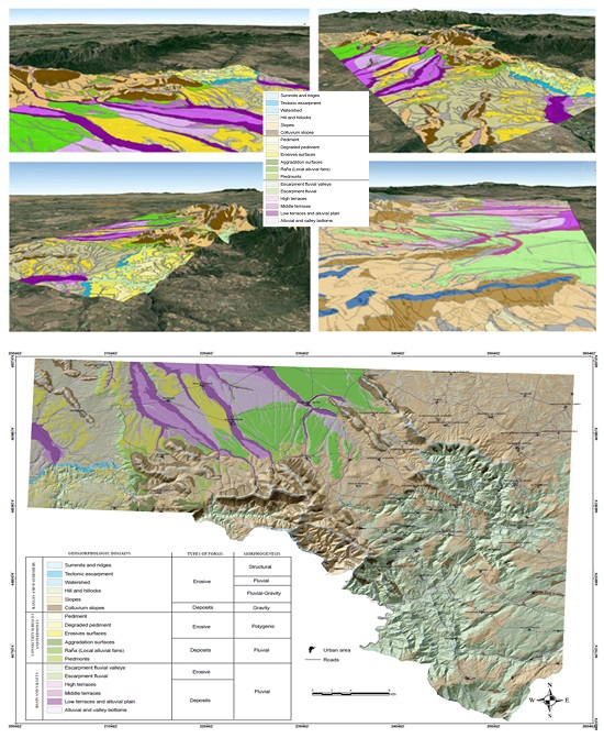
Figure 1). Detailed geomorphological cartography (geomorphological units) or simplified (geomorphic domains) is of great importance for the creation of synthetic cartographies such as landscape cartography (quality and landscape fragility), and all cartography necessary for strategic assessment procedures and environmental impact. Digital mapping takes advantage of the synergies of the avenues of other sciences (e.g., remote sensing), annually updating thematic cartography that, in paper format, is obsolete, either because the changes in the land uses are very fast or due to a lack of economic budget; an example is the Corine Land Cover Project.
The aim of this work is to show a methodology for using previous morphostructural zoning to establish—in detail—the geomorphologic units and their synthesis into different easily identifiable geomorphologic domains which can be applied to gain knowledge of the evolution of the landscape, for application in different environmental multidisciplinary studies [
18,
19,
20,
21,
22,
23,
24,
25,
26]. This detailed analysis of the different erosive and depositional geoforms serves as a basis to know the evolution of the landscape of a sector of Salamanca—a geomorphology that plays an important role. In this sector, geomorphological mapping at 1/50,000 scale has not been carried out, so one of the initial objectives is its elaboration for later use from the geological materials and their chronology of deposit or appearance; to identify the different paleogeographies, eliminating the materials sedimented in each epoch; and to describe the paleorelief based on morphostructures and morphogenesis mapped from the Paleogene-Neogene to the present. This is important for the study of the sustainability of the territory because “the past is the key to the present and the future”; that is to say, knowing the most recent behaviour and processes allows us to know the reason for our current landscape and the future trend of the relief. Therefore, one of the objectives of the work is to establish a methodology from the geomorphological–geological point of view as a tool for the analysis of palaeolandscapes and palaeoreliefs for the correct environmental and sustainable planning of the territory. Novel contributions of this work are that it constitutes a multitemporal integral analysis of the landscape, since it considers the internal geodynamic processes (genesis of the relief by granite intrusion, fracturing, and generation of horst and grabens, etc.) and external geodynamic processes of agents, such as water/river deposits), gravity, (colluvial, landslides), etc.
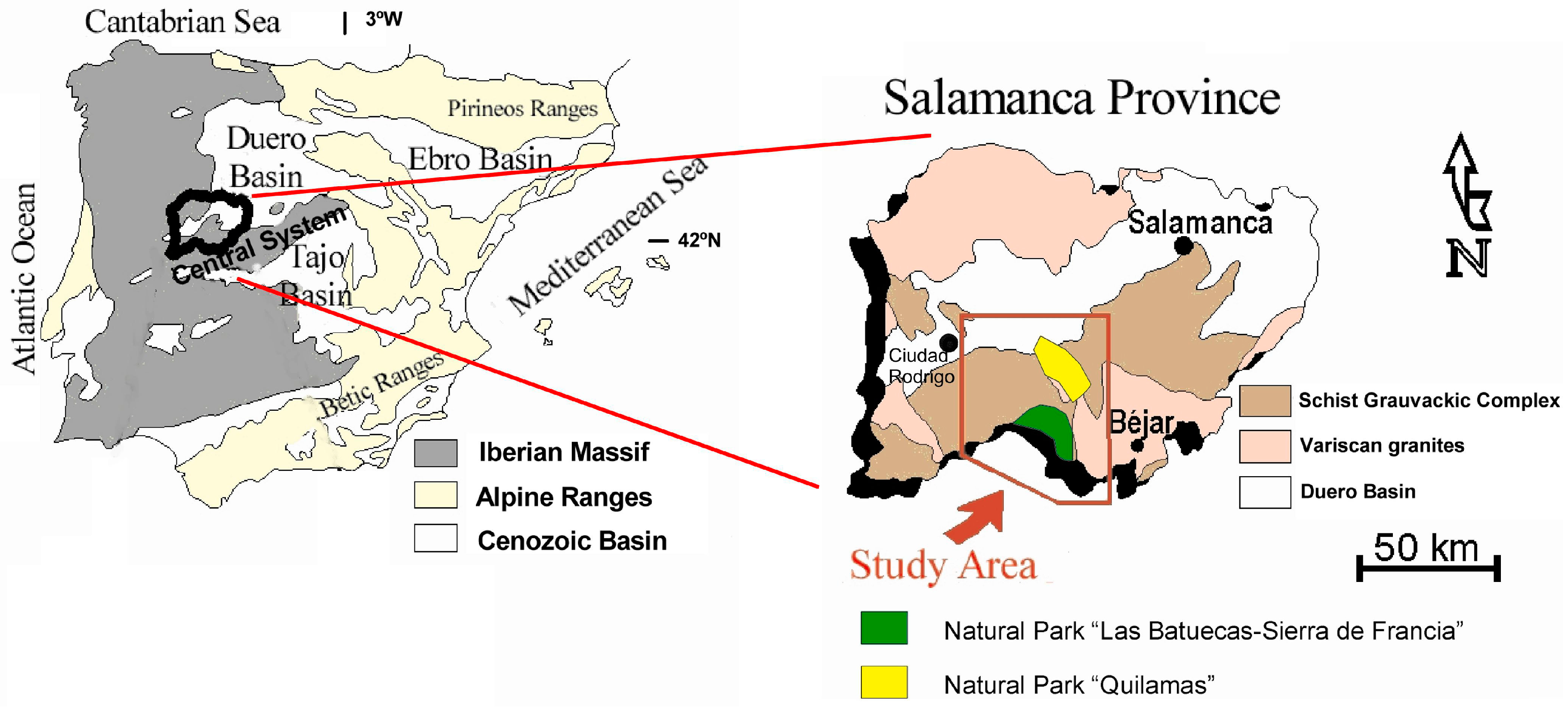
2. Study Area and Geological–Geomorphological Context
The Iberian Massif presents a remarkable topographic unit defined by large surfaces of levelling that concern all its lithological diversity. This uniformity is interrupted by the presence of some residual reliefs, generally constituted by quartzite alignments of major or minor importance, which represent the main structural lines of the Spanish Iberian Massif and stand out clearly in the landscape, forming mountain ranges. Alpine tectonics causes the massif to break into blocks, resulting in the individualization of large and small basins and depressions [
27,
28]. This study area is focused on the spurs of the Central Spanish System, in the south of the province of Salamanca and of the Autonomous Community of Castile and León (
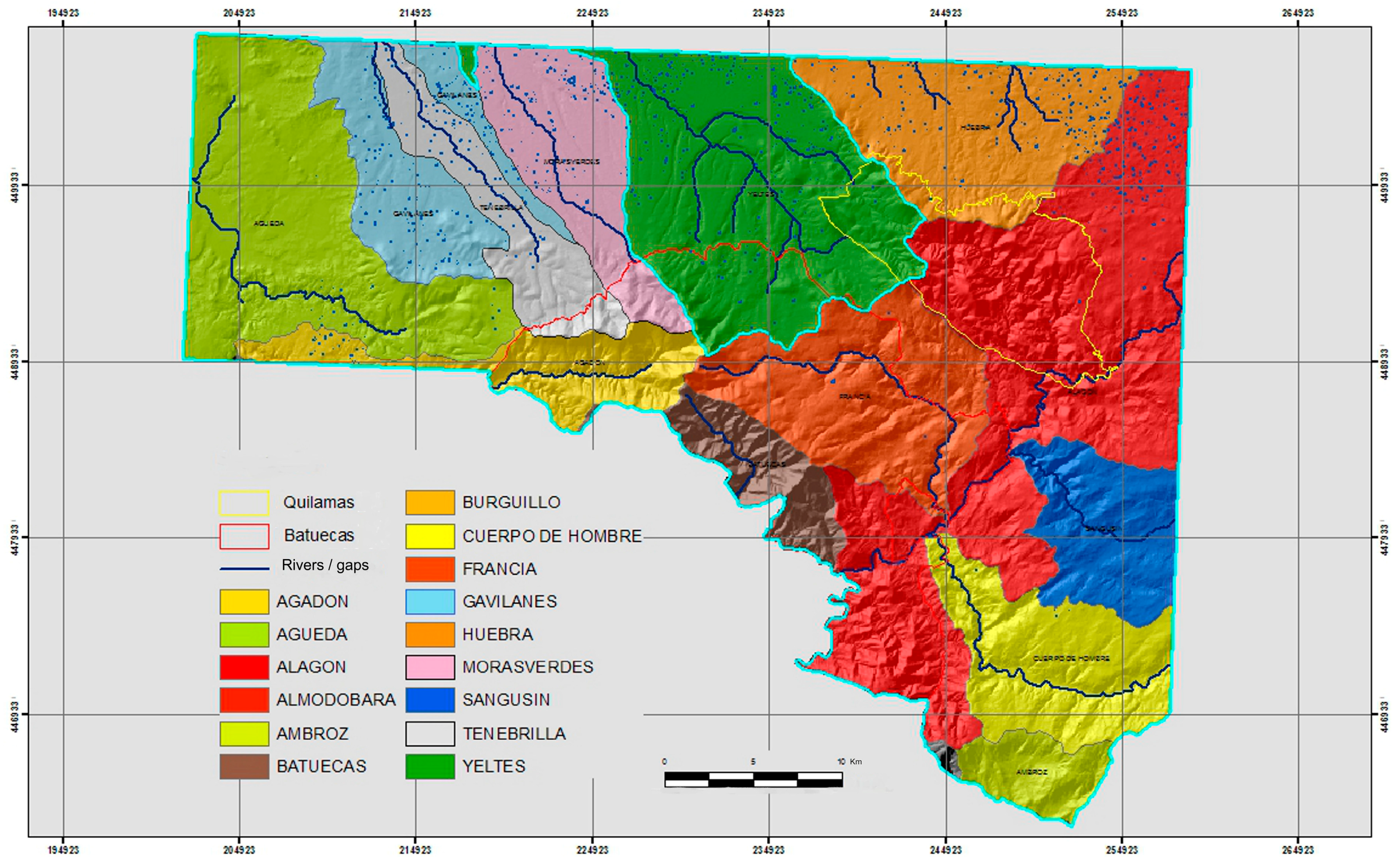
Figure 2).
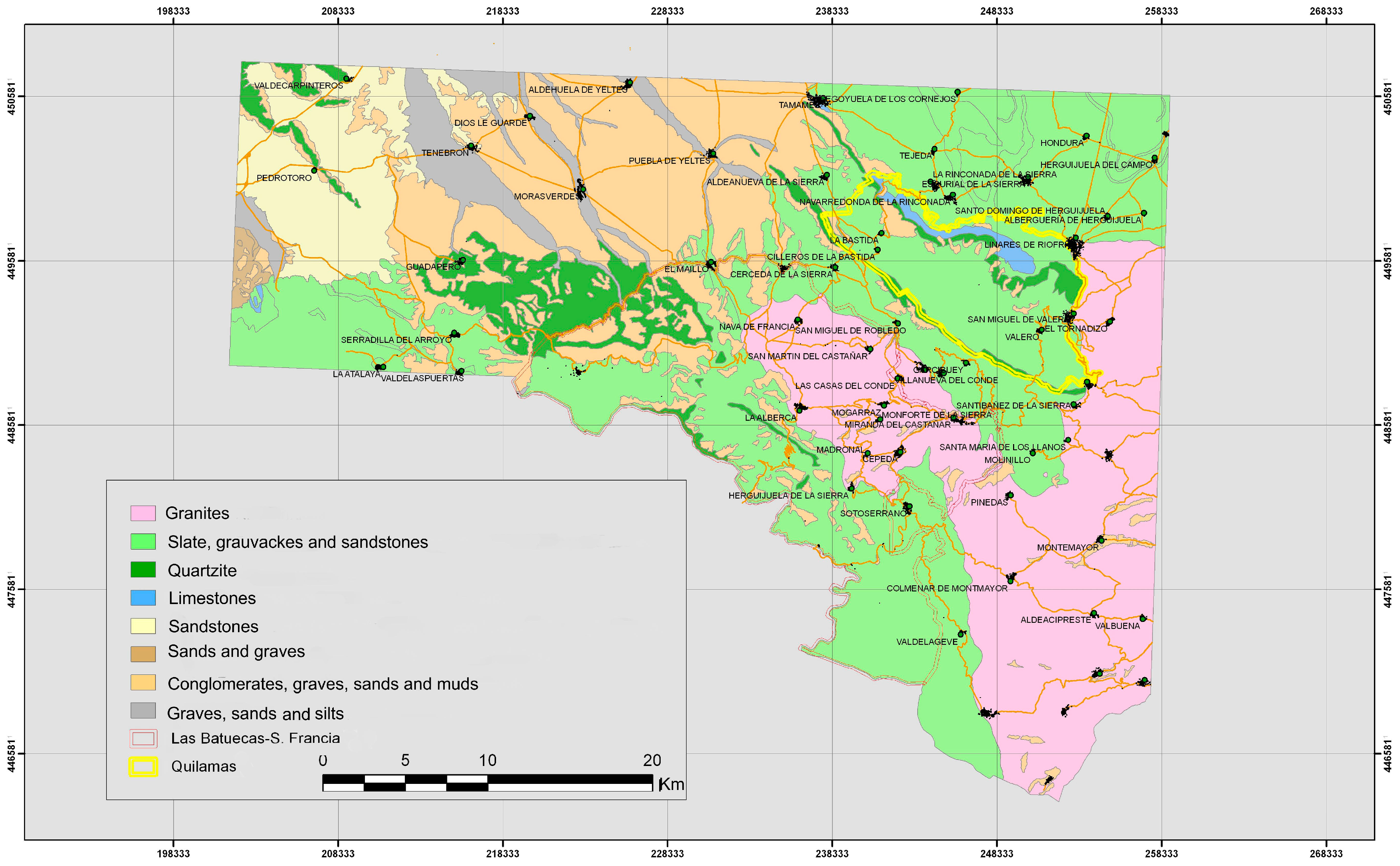
From the lithological point of view, the area is constituted by metasedimentary materials of the schist-graywackes complex from the Upper Cambrian, the Armorican quartzite from the Ordovician, and grey and black slates from the Silurian and Devonian, as well as granitic outcrops and Neogene sediments that constitute the pediment of the mountain ranges. Three large lithological sets can be remarked because of their importance in the development of the different forms (
Figure 3). The first set, which constitutes most of the mountain ranges, is characterised by thick banks of Ordovician-Silurian quartzite laying on pre-Ordovician slates and graywackes. The second set consists of the Variscan granitic rocks, which occupy less surface than the previous unit, and which are fitted into rocks of diverse nature, giving place to the corresponding metamorphic border and frequent dikes of quartz. Finally, there are the detrital sedimentary materials of alluvial character, which occupy large areas and fill the basin of Ciudad Rodrigo [
29,
30,
31,
32].
From the geomorphological point of view, three large morphostructural units could be differentiated in the western area of the Iberian Peninsula, conforming a typical relief: the mountain ranges and summits, the pediment, and the Cenozoic Basins [
33]; the Central System crosses the Iberian bedrock with a general NE-SW to E-W orientation, separating both subplateaus and individualizing the large fluvial basins of Douro and Tagus Rivers; the relief of this mountainous system is structured by a set of consecutive mountain ranges articulated across corridors or transverse pits with different morphostructures [
34,
35].
The mountain ranges are basically constituted of thick banks of massive quartzite which has remained preserved in syncline structures that are clear examples of “hanging synclines folding” due to its resistance to erosion. The pediment is constituted by large smoothed surfaces, independent of the lithology of the substratum, developed on top of the materials of the Iberian Massif. The basin of Ciudad Rodrigo is a tectonic depression, which can be considered to be a semi-graben, in which the shaping done by the river plays an important role in the degradation of its landfill and the exhumation of the ancient forms.
3. Materials and Methods
To establish the distribution of geomorphological domains in the natural areas of “Las Batuecas-Sierra de Francia” and “Quilamas”, we followed five stages:
The first step was to analyse the existing documentation, including publications (maps and items) of the study area and the research performed in the area based on photo-interpretation techniques as well as field and laboratory analysis.
The second stage consists of a detailed analysis of the geomorphology, climatic, and lithologic (substrate and surface formations) study sectors, determining the visibility of the forming factors and the morphostructural units. These units are digitalized based on general physiographic criteria, differentiating the legend into three large sets that correspond to ranges and watersheds, connection surfaces and pediments, and basins and valleys.
The third stage involves the use of photo interpretation (1/18,000 scale) delimiting the different units and associations, establishing a series of points/areas of interest with the purpose of simplifying different domains that include the different geomorphological units and obtaining the map of geomorphologic units [
36,
37] (
Figure 4).
The geomorphologic units obtained are then classified according to the types of forms they constitute—erosive and depositional—and bearing in mind the process or set of processes responsible for the genesis of every form or morphogenetic system (structural, fluvial, gravitational, and polygenic—
Table 1), being simplified in 18 geomorphologic domains.
In the fourth step, fieldwork was performed through a series of field campaigns—primarily during the summer, although there were certain departures in the spring. In these field campaigns, we determined specific points of the territory in which the best geomorphological units could be observed using natural terrain (piedmonts, colluvial, pediments, degraded surfaces, scarps, etc.).
The fifth stage represents the work of staff analysing the dataset obtained from the characteristics of different morphogenetic systems and transporting data from photo-interpretation—characterised “in situ” in field campaigns and cartography analyses—to produce the 1:50,000 scale topographic map. After processing, the dataset was digitised and implemented in a digital database using the geographic information system ArcGIS 10.4, (Redlands, CA, USA) which defines the different types of existing soils in these natural areas and the adjacent areas using different colours, patterns, and numbers. This process generates a layer of morphological attributes in the GIS database in the exportable format “kmz” and georeferenced in WGS84 to be displayed on free platforms, such as Google Earth. We used ArcGIS v.10.4 with the extensions Spatial Analysis and 3D Analysis. The data have been used in vector format points (urban areas), lines (contours, linear infrastructure), and polygons (geomorphological domains), as well as in grid format (orthophotos, etc.). The scale of the work was 1:10,000. The reference system used was Universal Transverse Mercator UTM-Datum- ETRS 89 in zone 30.
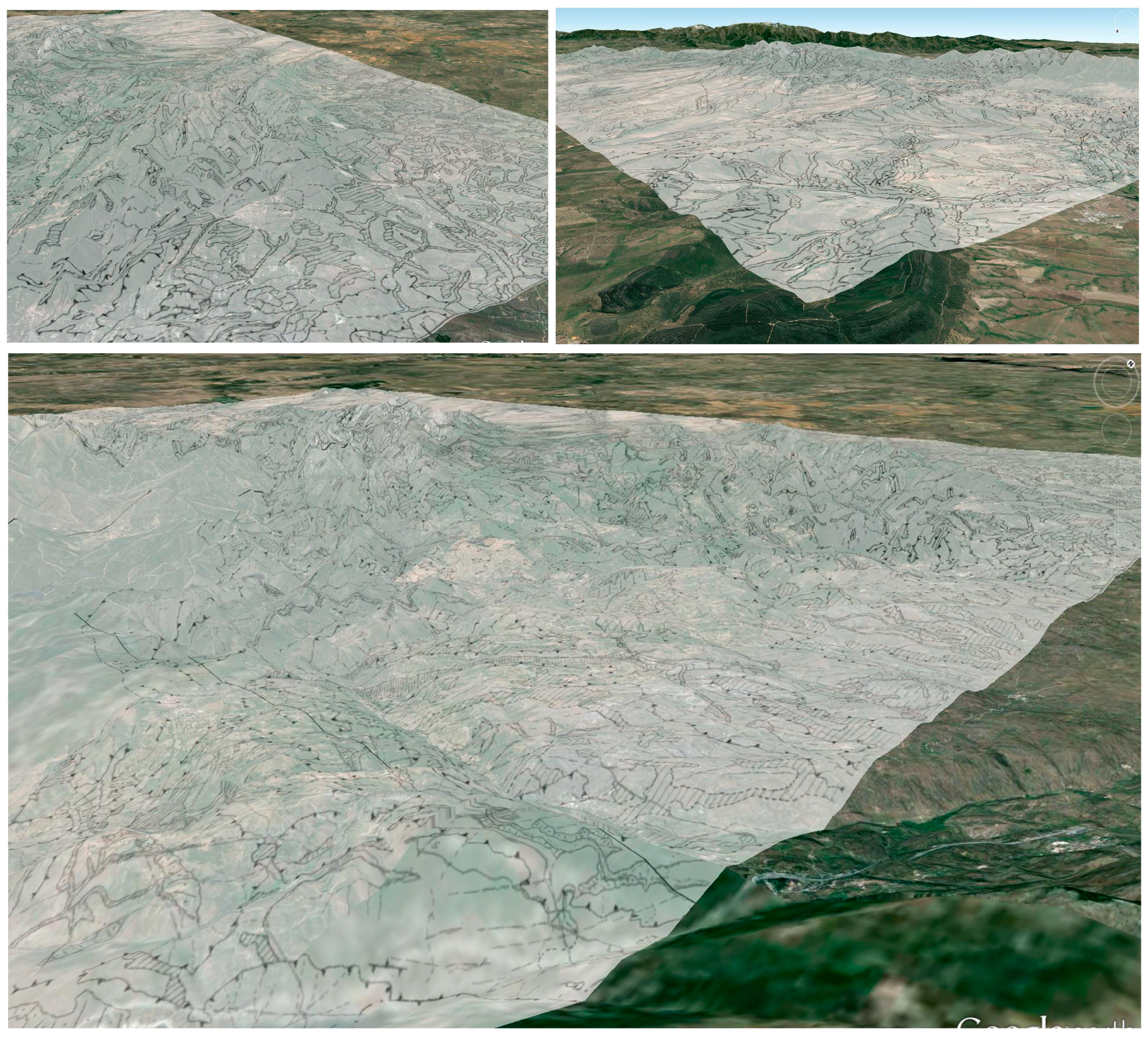
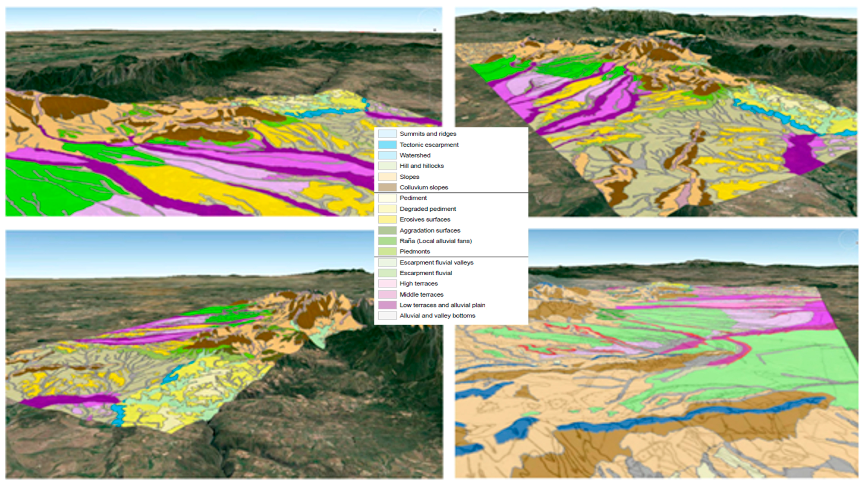
Finally, we conducted a 3D virtual analysis where we associated the geomorphological context on the three-dimensional model, and spatial reference information was provided along with the terrain height in real-time, interacting with 3D modelling in Google Earth, overlaying the geomorphological map on the orthophotos, and enabling or disabling, and making a zoom “+” or “−” view of numerical and graphical information of each stop [
38,
39]. Free virtual digital globes such as Google Earth were used to project this cartography and to analyse the spatial distribution of the different geomorphologic domains (
Figure 5). Finally, based on the relative age of the lithological units and the geomorphologic domains and superficial formations, as well as on their spatial distribution, the possible morphogenetic and chronological evolution in the zone of study was interpreted.
Although 2D cartography is very accurate (photointerpretation, fieldwork, etc.), its 3D implementation is important for improving the spatial vision of spatial planning and predisposes different administrations (non-specialized personnel) to understand the distribution of the different units with respect to the topography and toponymy of the study area, facilitating the multidisciplinary understanding of each thematic cartography and its interaction.
The domains and the geomorphological units integrated in these domains are described below, constituting a validation between the extracted map and the fieldwork that took place. The following 18 geomorphologic domains obtained are described below, grouped into three morphostructural units:
3.1. Ranges and Watersheds
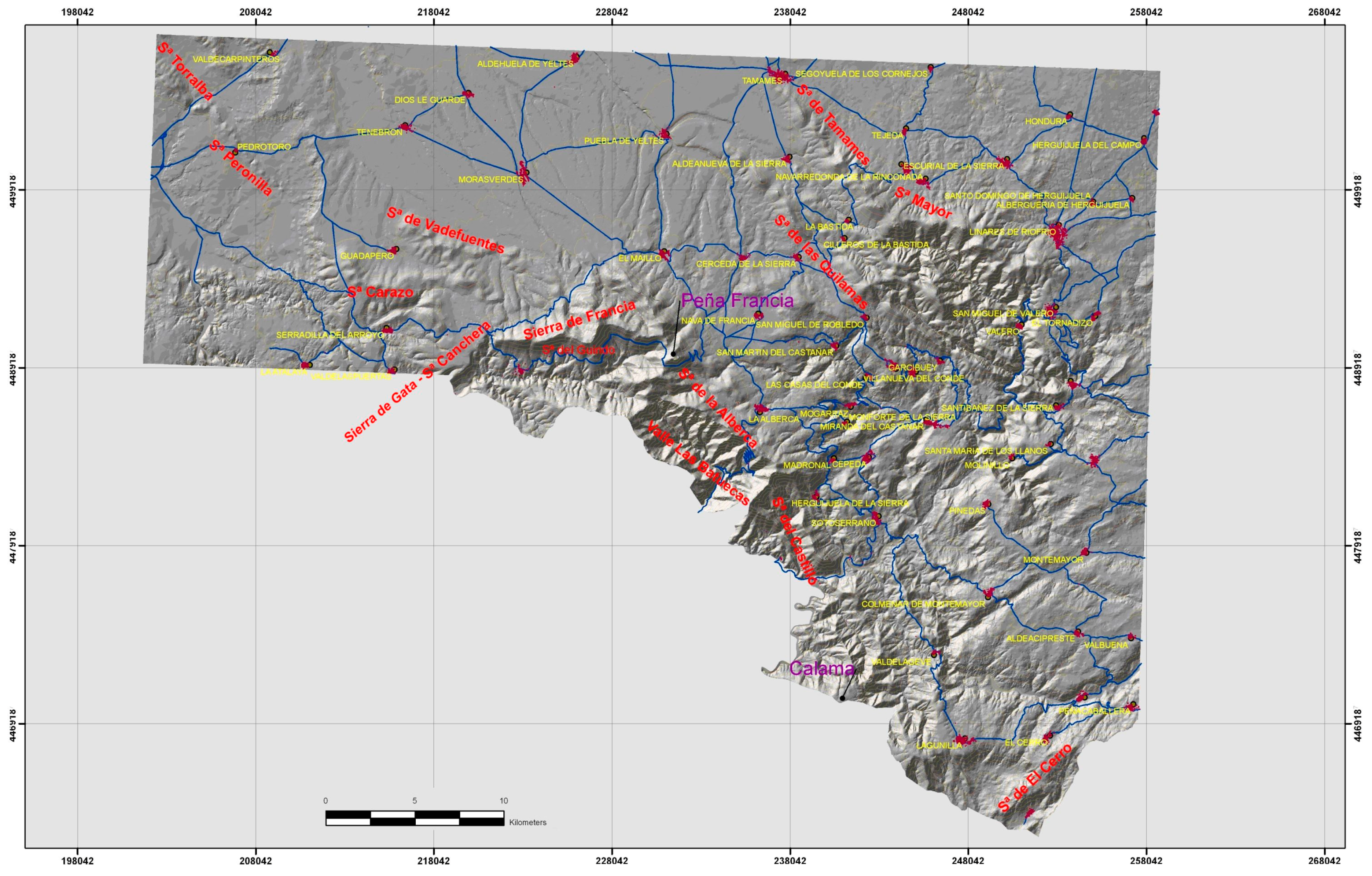
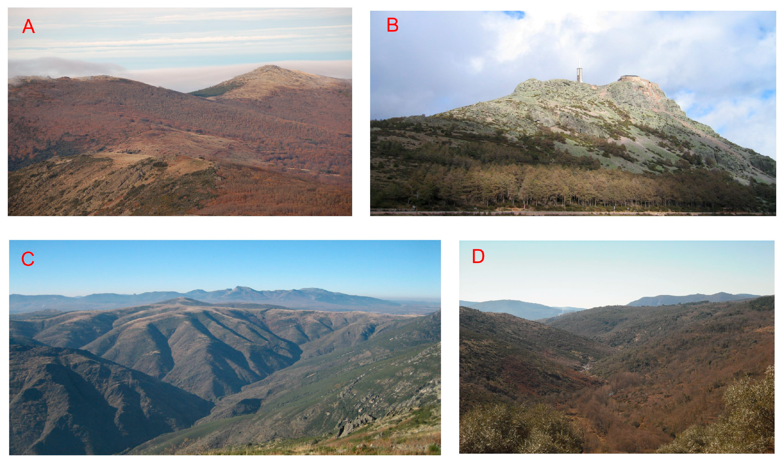
These include all of the geomorphologic domains that appear in the ranges’ morphostructural unit, as well as the fluvial divides generated by the strong incision of the drainage network on the morphostructural unit of the pediment. The ranges and watersheds are represented from west to east by the most oriental spurs of the Sierra Canchera (1397 m) and Sierra Peña de Francia (1723 m). In Sierra Peña de Francia, the maximum heights are Sierra Guindo (1462 m) and Hastiala (1735 m). In Sierra Tamames the maximum heights are Sierra Quilamas (1456 m) and Sierra Mayor (1463 m). Sierra Canchera follows a very marked direction SW-NE; and Sierra Peña de Francia, SE-NW and E-W, extending towards the NW in favour of the structure of the Guadapero syncline in the ranges that constitute both of its flanks (Sierra Carazo and Sierra Valdefuentes). These ranges present a continuity that finds its morphologic expression in Sierra Peronilla and Sierra Torralba, with their exhumed paleorelief inside the domain of the basin of Ciudad Rodrigo. Sierra Tamames follows a clear SE-NW direction and both flanks of the syncline, which give place to two parallel ranges, which can be perfectly distinguished (
Figure 6).
3.1.1. Summits and Ridges
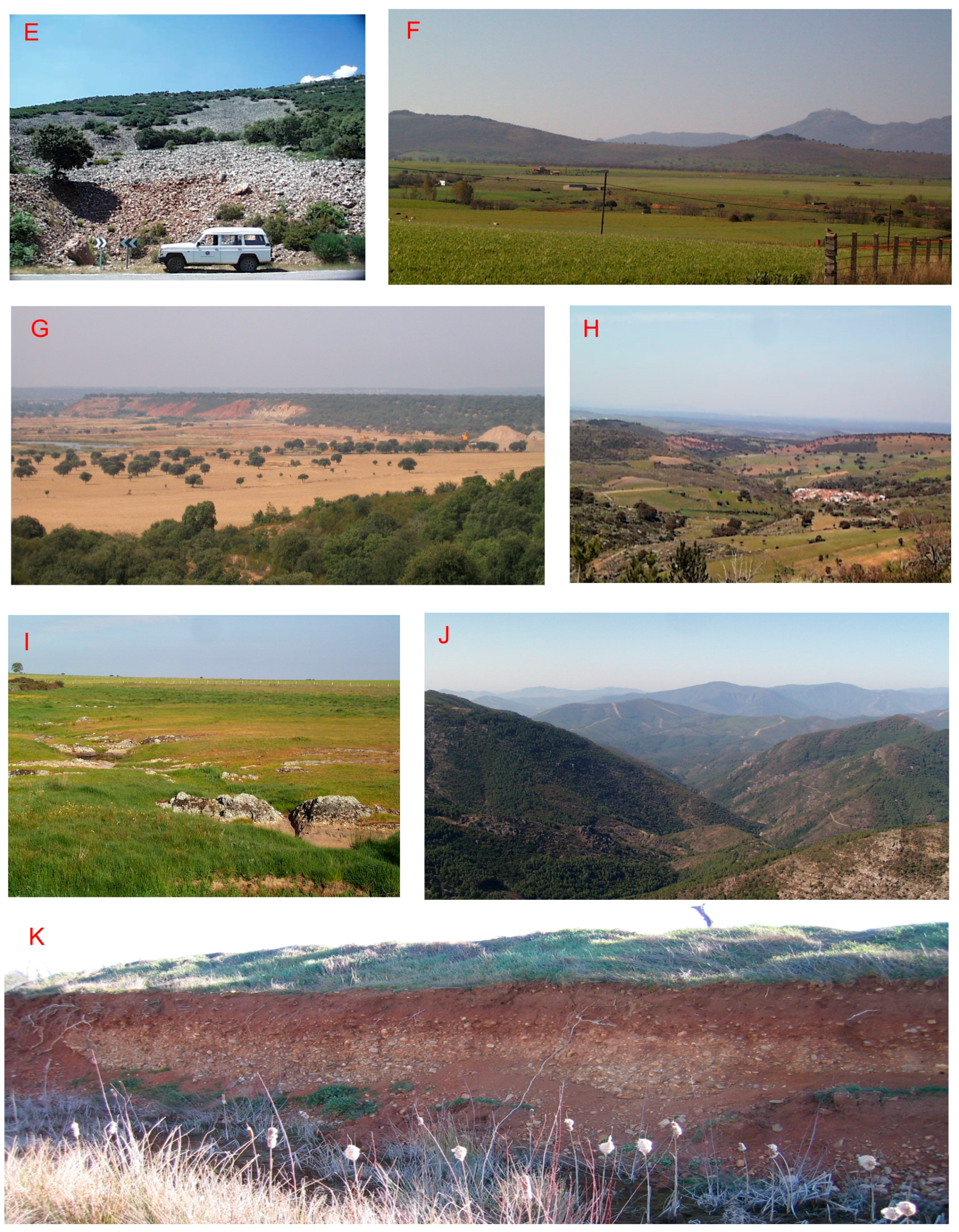
These are erosive forms of structural morphogenesis that are located in the domain of the ranges. It is not possible to speak about summit areas, since all of them are constituted by relatively narrow edges that have been formed due to lithological contrast. Most of them are developed on quartzite lithologies that—because of their major resistance to the erosion—have remained preserved and stand out in the landscape over the slate lithologies on which they support. In some cases, when these quartzite banks are not present, they are constituted by slate, which results in a softer profile (
Figure 7A,B). Cartographically, they do not occupy large areas. They appear as sinuous and narrow bands of not more than 200–300 m in width, placed at levels from 1100 to 1750 m. They also appear as exhumed reliefs in the morphostructural domain of the basin of Ciudad Rodrigo at levels between 750 m and 850 m.
3.1.2. Tectonic Escarpment
This is an erosive form of structural morphogenesis that constitutes the joint between the pediment of Sierra de Gata and the basin of Ciudad Rodrigo. The fault that produces these tectonic scarps has a W-E orientation, is a part of the southern limit of the basin of Ciudad Rodrigo, and develops on slate metasediments that constitute the schist-graywackes complex (
Figure 7H). Cartographically, it does not occupy a large area and appears as a narrow and elongated band. This relatively degraded morphological scarp spans a slope of between 70 m and 100 m, the upper surface corresponding to the pediment of Sierra Gata and the lower surface to the base level of the Águeda River basin, which is already in the basin of Ciudad Rodrigo.
3.1.3. Watersheds
These are erosive forms of fluvial morphogenesis that are located in the south, due to the major erosive power of the fluvial network belonging to the Tagus basin. Most of the pediment that should have developed on slate metasediments has been dismantled (
Figure 7C). This strong fluvial incision has shaped a set of watersheds, caused by the continuous setback of the hillsides and characterised as very narrow and acute edges on the previously-mentioned materials. Cartographically, they occupy a limited extension and appear as very narrow bands of little longitudinal continuity. They are always inside the large fluvial incisions, and their maximum level does not overcome 900–950 m, the level that the surface of the ancient pediment—from whose dismantlement they result—would have.
3.1.4. Hills and Hillocks
Hills and hillocks are erosive forms of mixed, fluvial–gravity morphogenesis. Cartographically, they occupy most of the basin of Ciudad Rodrigo, since they represent all of the hillsides developed on the materials that constitute the basin’s landfill. As these are soft and easily eroded materials, they cause a large-scale wavy landscape where convex shapes are predominant. In general, they do not present important coverings of the hillside. The materials on which they develop are of detrital, either arkosic sediments or the sediments in red alluvial fans. They always appear below the level of 900–1000 m, which is the ceiling of the basin’s sedimentary landfill (
Figure 7H).
3.1.5. Slopes
These are erosive forms of mixed fluvial–gravity morphogenesis located fundamentally in the morphostructural domain of the ranges. These forms include all of the hillsides of the ranges that do not present remarkable coverings of colluvial sediments or erosion of the hillside. Therefore, they are mainly naked hillsides in which the original lithology can be directly seen, or which present not very thick soils and a generally concave profile. They mostly develop on slates and schists, though they can also appear on granitic rocks when these are part of the ranges. Their cartographic extension is relatively important, and they appear as bands of variable width that border the domains of summits and ridges. They are therefore located between the levels of these summits and ridges and the base level of the fluvial courses that originated there (
Figure 7D).
3.1.6. Colluvium Slopes
Colluvium slopes correspond to deposit forms of gravitational morphogenesis that are in the morphostructural domain of the ranges presented by the hillsides included in this category in the form of more or less thick coverings of hillside erosions and/or colluvium and the characteristic rock fragments of quartzite locally referred to as “canchales” (
Figure 7E). Their cartographic extension is important, and they appear forming borders of variable width around the domain of summits and ridges or are associated with naked hillsides. They are located between the levels of the domain of summits and the base level of the fluvial courses that drain the mountain range. The lithology of these deposits is controlled by the nature of the materials that form the hillside.
If the hillsides develop in slate, metasedimentary materials, the colluvium is constituted by slate pebbles embedded in a clay and silt matrix that has a significant reddish colour. If the hillsides develop on granitic rocks, the colluvium is formed by granite pebbles with variable proportions of sand, the presence of fine granulometries such as silts or clay being scarce. However, canchales will develop when the hillsides develop on metasedimentary quartzite materials, or if these materials are crowning the hillsides, constituted by angular quartzite pebbles without any type of matrix that moves down the hillside.
3.2. Connection Surfaces and Pediments
These include all of the geomorphologic domains constituted by flat, more or less degraded, surfaces which form the link between the domains of watersheds belonging to the ranges, and those belonging to fluvial valleys. The pediments form a border around the ranges. In Sierra Peña de Francia, they are constituted by alluvial fans from the Neogene age and form the top of the Tertiary landfill of the basin of Ciudad Rodrigo. We consider as pediments the surfaces free of sediments and not fossilized by them (
Figure 7F).
As for sector W, a naked pediment can be found constituting the linking zone of the pediment surface that descends from the reliefs of Sierra Peña de Francia, with the Paleogene and Neogene landfill of the basin of Ciudad Rodrigo. Its height is approximately between 750 m and 850 m, with a trend to decrease towards the W and NW. It corresponds to the degraded remains of an exhumed, ancient surface, inherited from a morphologic cycle previous to the Neogene that gives shape to the pediment of Sierra de Gata, placed to the SW of Sierra Peña de Francia. Towards E and SE, this pediment presents different morphologic features due to the lithological change, which in this sector is predominantly related to quartzite. Here the breakage of the slope is produced at levels between 950 m and 1000 m, and spheroidal weathering is typical where the residual reliefs are the characteristic “inselbergs” or dikes of quartz that stand out in a morphological level. The pediments located on metasediments are totally eroded, and of those remaining, only some of them hang in the highest zones [
40].
3.2.1. Pediment and Degraded Pediment
This pediment constitutes an erosive form of polygenic morphogenesis that occupies large cartographical extensions. It is located at the base of all the reliefs in the zone, and it is characterized by being free of sediments, since it constitutes a relict surface now exhumed. It corresponds to an etchplain surface previous to the Neogene and Paleogene that at some point was the base for the thick alteration mantles that covered it. The dismantlement of these altered rocks at the end of the Mesozoic and during the Paleogene and Neogene made these pediments remain exhumed and submitted to all of the subsequent processes of weathering and erosion [
40]. This pediment is characterized by a soft, undulating landscape in which the pediment’s domain corresponds to the flat surfaces that form the high parts of these waves, whereas the degraded pediment’s domain corresponds to all of the smooth hillsides located between the flat surfaces and the lower parts of the waves in the area (
Figure 7I).
3.2.2. Erosive Surfaces
These correspond to erosive forms of polygenic morphogenesis. They are very well cartographically represented in the south of Sierra de Torralba and Sierra de Peronilla, developed on the Arkosics in the basin of Ciudad Rodrigo. They constitute a flat, pediment-like surface with a light slope from the foot of these ranges at a level of approximately 700 m, up to the proximities of the Águeda River at an approximate level of 650 m, where they are cut by the incision of the river.
3.2.3. Aggradation Surfaces
Aggradation surfaces are forms of deposit of fluvial morphogenesis that represent the ceiling of the sedimentary landfill of the basin of Ciudad Rodrigo, therefore corresponding to the last sedimentary episodes of the Neogene alluvial fans. They are flat surfaces laying on the conglomerates and mud that constitute the sedimentary material of the fans. Their minimal level is 930 m, and their maximum is 1050 m, since they can be uneven due to fractures.
3.2.4. Raña (Local Alluvial Fans)
These correspond to forms of deposits originated from fluvial morphogenesis that either crown the last deposits of the landfill of the basin of Ciudad Rodrigo or are lightly fitted into them. They constitute a system of platforms which are lightly inclined towards the north. In the west, these platforms of pediment are hanging more than 100 m over the main riverbeds of the drainage network that belongs to the Águeda River. They are superficial formations with pedomorphological connotations characterized by the extensive pediment-like surface that they define. The materials corresponding to the different levels of raña lie directly on the deposits of the Neogene fans and result from their remobilization by later processes, which in many cases makes their differentiation very difficult. They appear at levels between 1050 m in its head-boards and 800–850 m in more distal zones.
3.2.5. Pediments
These are deposit forms of fluvial morphogenesis that create a narrow border around the reliefs of the ranges. They correspond to deposits constituted by relatively angular slate and quartzite pebbles with silt or clay, in a reddish-coloured matrix. They are located either on the substratum lithologies from which they result, or on the surfaces of Neogene fans and raña. Their slope is slightly more pronounced, but less than that of colluviums. They are approximately at levels between 1000–1100 m at a maximum, and 900–950 m at a minimum.
3.3. Valleys and Basin
This paragraph will include the set of geomorphologic domains directly related to the fluvial morphogenesis and associated with the current fluvial network. The basin of Ciudad Rodrigo constitutes an intracratonic basin that can be considered to be a semi-graben, originated as a consequence of the Alpine tectonic activity. Some essential morphological factors may be named here: a northwestern edge tilted towards SE and an eastern edge of varied morphology where remains of a morphogenesis complex coexist with more recent elements. This edge is determined by a remarkable fracture—the Fault of Ciudad Rodrigo—and by fluvial modelling with important processes of dissection.
Only its most southeastern side is represented in our area of study, but it constitutes an essential morphostructural element in the configuration of the landscape in all of this sector. The landfill of this basin has been produced by the evolution of the fluvial systems during the Paleogene and Neogene that, adding sediments from both edges, were orientated towards their main axis to come up to the basin of the Douro. The first sedimentary set (allegedly Paleogenic) rests directly on the Variscan socle. It presents an arkosic character with a grain size that varies from sandy and silt to conglomerates. Its power is variable, increasing eastward, where it can visibly exceed 80 m.
The second sedimentary set of the basin, which forms the landfill ceiling, is formed by a set of alluvial fans from the Neogene age which come from Sierra Peña de Francia, whose apexes are approximately 1050 m high in the front sides of the range. The most distal zones are located at approximately 800 m. Morphologically, they are crowned by a system of platforms known as rañas, slightly tilted towards the north. Two or three levels can be distinguished which barely fit one into another, and they may be considered to be the beginning of the dissection of the basin’s landfill, immediately previous to the development of the first fluvial terraces. This second sedimentary set is the one that fossilises the ancient pediment of the north sector of Sierra Peña de Francia and constitutes the current pediment of these reliefs. All of this sedimentary landfill of the basin is now being cut by the fitted fluvial network, the rañas being the first surfaces that appear, immediately previous to the development of the first fluvial terraces.
3.3.1. Escarpment Fluvial Valleys
This domain refers to erosive forms of fluvial morphogenesis that include the whole valley, from the top of the slope to the riverbed in its lower part. Almost all of the fluvial incisions correspond to valleys with a “V” morphology and represent a great part of the zone of study (
Figure 7J). Almost the whole fluvial network belonging to the hydrographical basin of the Tagus originates with this type of valley (
Figure 8).
These fluvial incisions present a very marked geomorphological reflection when they appear on the pediment, but when they reach the range areas they show similar characteristics to the hillsides or colluvium hillsides, making their individualization problematic. They are constituted by hillsides, with a pronounced slope and very few associated hillside deposits. When they appear on the surfaces of the pediment, the scarps for which they compensate can be up to 400 m high. These strong incisions develop both on the slaty lithologies of the schist-graywacke complex and on the granitic lithologies, these being of major importance for the following reasons:
Almost the whole granitic area is drained by the Tagus network, whose base level is around 200 m below that of the Douro, which are precisely the one which drains the slaty lithologies; and
In the granitic area, the unevenness of blocks is more evident due to the breakage, so the surface of the pediment is already at different levels. In many cases, the alluvial and river valleys are also included in these domains.
3.3.2. Fluvial Escarpment
This corresponds to the erosive forms of the fluvial morphogenesis and represents all of the fluvial scarps that are generated by the canalisation of rivers in the morphostructural unit of the basin of Ciudad Rodrigo (
Figure 7G). They are basically at the edges of the alluvial plains and low terraces of Tenebrilla, Morasverdes and Yeltes Rivers, as well as some of their tributaries. They are variable-sloped walls—almost vertical in some cases, whereas in others they are so degraded that they produce flatter forms. They compensate for very variable gradients of between approximately 8–10 m (Tenebrilla when flowing through Tenebrón) and 50–60 m (Yeltes River in Aldehuela de Yeltes). The most important scarp has a N-S orientation and forms the water divide between the basins of Águeda and Yeltes Rivers (
Figure 8). This scarp is around 100–120 m high and originates with the difference between both fluvial courses’ base level, in a way that the greater erosive power of Agueda’s network makes the mentioned scarp move back progressively, thus capturing the head-boards of the creeks belonging to Yeltes River. All of them develop on the arkosic lithologies or come from red conglomerates that are part of the landfill of the basin of Ciudad Rodrigo. Since these are soft materials, they can undergo slide and avalanche processes which are especially visible when they are free of vegetation, as is the case of the scarp of the Yeltes in Aldehuela de Yeltes’ proximities. Gullies may also develop in some cases.
3.3.3. High Terraces
These are forms of deposits of fluvial morphogenesis included among the terraces, whose level over the current riverbed in the main rivers is more than 15 m high. They are clearly represented, and some of them are slightly fitted into the raña surfaces. It is sometimes very difficult to establish the limit between them, since they appear as small scarps which not more than 1–2 m, and are very degraded and stretched. Their lithology is similar to raña and fans, although quartzite and quartz pebbles are more rounded and also embedded in a sand–clay matrix of reddish colours.
3.3.4. Middle Terraces
Like the previous unit, they are forms of deposit of fluvial morphogenesis associated with the same drainage network, but whose height is between 15 and 50 m on the current riverbed. In this case, they are slightly fitted into the high terraces and also appear as small scarps which are very degraded and flattened.
3.3.5. Low Terraces and Alluvial Plain
These are forms of deposit of fluvial morphogenesis and group together the alluvial plains and the lowest terraces, lower than 12 m on the current riverbed. They appear as narrow elongated bands with a N-S to NW-SE direction, formed by quartzite and quartz pebbles (also slate pebbles to a lesser extent) in a sand or silt matrix of reddish-brown colour. They do not generally appear cemented, so they often constitute very appropriate areas for aggregate exploitation (
Figure 7K).
3.3.6. Alluvial and Valley Bottoms
These are forms of deposits of fluvial morphogenesis and include all of the sediments of the primary and secondary drainage networks, but only those which do not develop such extensive alluvial plains. Cartographically, they appear as very narrow and elongated bands that follow the riverbeds. They are constituted by conglomerates, gravels, and sands, whose character fundamentally depends on the material that forms their drainage basin. As it happened in the case of the low terraces and alluvial plains, they are very appropriate areas for aggregate exploitation, due to the fact that the materials are not cemented.
4. Results
4.1. Morphogenetic and Chronological Evolution of Landscape
Throughout the Mesozoic, the residual reliefs in our zone of study established morphologic features generated by long stages of alteration and soft lateral tilting movements, producing very smooth and mature morphologies that determine the structural features of the peneplain in this sector of the Iberian Massif. These surfaces have undergone a polygenic morphogenesis, generating the pediment and the degraded pediment. The detrital sedimentary record that followed this Mesozoic cycle has been interpreted as a response to a new morphostructural situation as a result of the Neogene and Paleogene Alpine tectonics. This phase of tectonics produces new depressed areas that act as centres of detrital sedimentation and high blocks that constitute the most remarkable reliefs in this zone. In the area of study, this activity is shown by the movements of pre-existing Variscan faults, which produce a new structure of blocks and produce the reliefs that form the Central System (Mountain ranges) and depressions (basin of Ciudad Rodrigo) (
Figure 9). This new situation causes a part of this fundamental peneplain or pediment to remain buried under the Paleogene sediments of the basins, constituting its basement. This block tectonics is responsible for the current asymmetric geometry of the basin of Ciudad Rodrigo, with a net eastern limit that defines the highest block, and a less-defined western limit in which the basement gradually disappears under the first sedimentary cycle of the basin. We can establish three morphogenetic stages:
4.1.1. Arkosic Stage: Definition of the Sedimentation Basin (Paleogene)
The landfill of the basin of Ciudad Rodrigo is due to the evolution of the Paleogene/Neogene fluvial systems that were oriented towards their main NE-SW axis (Douro’s Basin). The first sedimentary set—to which an Eocene/Oligocene age is attributed—presents a subarkosic character where a series of diagenetic alterations have been identified. Its essential origin is the eastern and southern metasediment socle, and the sediments correspond to environments with a seasonal regime, wide sand and mud plains, and abundant organic settling. The arkosic sedimentary contributions produced in the Oligocene comes from western and southwestern granitic areas, being all of the petrologic components of the parent rock almost entirely represented in it. This sedimentary regime seems to have been associated with open landscapes with seasonal fluvial courses which come from a socle with attenuated reliefs and shallow remains of degrading alterations. The arkosic and subarkosic sediments are interfinger-shaped, which implies a synchrony between the contributions of the western granites and those of eastern metasediments [
40].
4.1.2. Post-Arkosic Stage: Change in the Drainage Network and Beginning of the Dissection (Neogene)
It is possible to think that the beginning of this period occurs when the fluvial network—still in the aggrading stage—ends up adopting as head-boards the oriental reliefs that had previously kept a secondary character in terms of the Paleogene basin’s landfill. Therefore, the most remarkable event that defines the beginning of this stage—that is going to develop during the Neogene—consists of the change in source areas and probably also in the water regime. This change is the result of the effects of Alpine tectonics, which would be responsible of these reliefs’ renewal, besides the progressive adjustment of the drainage to the orographic and water conditions. The sedimentation in this stage constitutes the ceiling of the basin’s landfill, formed by a set of alluvial fans from the Neogene age proceeding from Sierra Peña de Francia. Its apexes are located at a maximum level of 1050 m in the front zones of the range, whereas the most distal zones reach an approximate level of 800 m. Morphologically, they are crowned by a system of alluvial fans named rañas, among which two or three levels can be distinguished, slightly fitted one into another, and the lowest being directly related to the current riverbeds. The last geographical feature related to the depression’s landfill consists of the development of the last Neogenic sedimentary sequences of a process of levelling/collapse regulated by a groundwater dynamics, with a superficial or sub-superficial run-off. This process would cause the construction and regulation of one or several platforms developed on the last sedimentary sequence of the Neogenic alluvial deposits.
4.1.3. Quaternary Stage: Dissection and Fluvial Deposition
The area of study includes the hydrographic basins of the Douro and of the Tagus, being the axes of Sierra Canchera and the western spurs of Sierra Peña de Francia being the divide between both of them. This divide becomes not so clear towards the east, since the hydrographic network of the Tagus has exceeded this axis of the mountain range. Between both basins, a total asymmetry can be distinguished in these ranges’ northern and southern slopes.
The soft descent towards the Douro basin (north) contrasts with the sudden embedding of the fluvial network that flows into the Tagus (south), with differences of up to 200 m between both basins, just at the base of the reliefs.
Precisely these differences in the base level of the fluvial courses of both basins has caused the network of the Tagus, with a major erosive and upstream power to have captured the head-boards of the Douro network in the eastern and southeastern part of Sierra Peña de Francia. It has already been mentioned that in the early Neogene, the Douro fluvial network underwent a change in its source areas, which became definitive when the fluvial network adopted the eastern reliefs as its head-boards. This change was followed by the progressive capture of the former fluvial network by the Atlantic network, which caused the partial dismantlement of the sediments that filled the basin of Ciudad Rodrigo and its dissection.
A remarkable topographic difference can be observed in the northern slope of Sierra de Francia, on the one hand related to the drainage systems of the Huebra and Yeltes Rivers, and on the other hand, the Águeda River. The first two drain the northern pediment, over 800 m high, whereas the Águeda is embedded more than 100 m below the mentioned pediment, eroding the Paleogene and Neogene sedimentary cover and exhuming the former pediment that constituted a link between the peneplain of Salamanca in the north and Sierra de Gata in the south. This difference may be attributed to the fact that the incision of the Águeda fluvial network in the naked pediment is epigenetic and possibly contemporary to the Paleogene sedimentation of the basin. However, the incision that is observed in the Yeltes River—developed on the materials of the late Neogene of the basin of Ciudad Rodrigo—is a clearly Quaternary process. When it comes to the Águeda River, there is an erosive stage in the sector of the Sierra de Gata’s pediment that is contemporary to its raising at the beginning of Paleogene and Neogene. This would explain the sedimentation of the subarkosic formation of Ciudad Rodrigo and their metasedimentary character, coming from the exhumation of the etchplain [
41]. The rest of the gorge would be built up as soon as the headwater erosion of the Águeda River captured the basin. Thus, when the Atlantic Águeda reaches the eastern edge of the basin, it captures a part of the Águeda River that arrives at the basin via the pediment of Sierra de Gata, and it continues with the incision of the previous gorge. As for the embedding of the Yeltes River, and therefore the degradation of the northern pediment of Sierra Peña de Francia, they correspond to the upper Neogene, whilst the set of its well-developed terraces are Quaternary.
4.2. Morphogenetic Evolution Applied to Landuse
From the results indicated in the
Section 4.1 and identifying the geomorphological domains grouped according to the types of forms and their morphogenesis in the geomorphological map, we established their environmental sustainability in the reception capacity of possible human activities. The host capacity and resilience was analysed according to the natural problems (lithological, geomorphological, geotechnical, etc.) that these evolutionary units present in the planning of human activities.
The sustainability for land use in range and watershed sectors depends on the type of rock outcrop. Areas formed by granitic materials can present processes of erosion and disintegration from weathering. From the hydrogeological perspective, this area comprises impermeable materials wherein the permeability limits the area to fractures and jointing. The alteration of this granitic mass produces an intense sand alteration that promotes intergranular permeability. The geotechnical characteristics are suitable, with granular, altered soils with the granite at a low depth, generating zones with high load capacity and acceptable seats.
The domains of summits and ridges have high load capacity and minimal seats, due to being saprolitic compact of granitic alteration with nearness of fresh rock. The domain comprising colluvial hillsides are unstable at the superficial level for side thrust forces that promote slopes.
In terms of the sustainability in areas formed by metasediment materials composed of complex schist and graywackes, from the hydrogeological perspective, they are materials with low permeability and infiltration processes that are favoured by alteration and fracturation. This impermeability is promoted by clay formation due to alteration of these lithologies and can entirely or partially “seal” the fissures therein. From the geotechnical perspective, certain zones are highly altered and comprise different seats in superficial foundations with isolated footings. Construction conditions are acceptable in unaltered or slightly upset rock. Banks with middle and high slopes can induce slides that favour foliation planes in the slates. The quartzite and schists may yield problems with detachment or falling blocks.
The domains comprising hillsides and scarp with high slopes generate take-offs that favour stratification planes and middle seats in zones of intense alteration. This zone is stable in the domains that comprise summits and motions with few alterations and soft slopes.
From the hydrogeological perspective, areas formed by carbonate rocks are considered materials with moderate permeability, and the most dominant processes that affect this area are dissolution and fracturation. The load capacity is high on the compact rock with slightly significant processes of karstification; however, collapses or structure subsidence may be a problem.
The sectors formed by Neogene and Quaternary detrital materials are arkoses of the Miocene with former alluvial fans covered by extensive surfaces that comprise deposits superposed with alluvial fans from the Pliocene-Quaternary (locally, “Rañas”) and terrace deposits from the Pleistocene associated with fluvial riverbeds, hillside deposits (colluvial and scarpment), and alluvial sediments in valley funds. In the domains comprising substratum arkoses in summits and motions with stretched slopes, the load stability and capacity is high for acceptable seats.
The zone with gravels, sandstones, and shales that are arkosic has low permeability and drainage that promotes intergranular porosity. This high degree of consolidation generates compacted and stabilised natural conditions; the load capacities are moderate-discharge, and this area does not contain seats. The arkosic, with hanging middle-discharges, concentrate the rain run-off, which generates instability for the gullies and gulches.
The deposits of conglomerates, gravels, sands, and red muds that compose Neogene alluvial fan deposits that compose the Raña of the Pliocene-Quaternary have clay light slopes that can generate gravel movement in favour of the levels overlain. The permeability of these materials is low–moderate, with drainage for intergranular porosity. The groundwater level may interfere especially at the sludge levels, the load capacity is low, and the generated seats are middle.
The alluvial plain deposits and valley funds present a lithology formed by gravels, sands, and free silt with low and very low slopes. The permeability of these materials is moderate–high with drainage for porosity.
In the flood plains and intermittent riverbeds, the groundwater level is at a low depth, and they are potential flood zones with low load capacities and likely significant seats. The terrace deposits comprise zones with acceptable load capacities and small seats because the detritic reorganisation adapts rapidly to the applied stresses. The colluvial and screes materials destabilise wide hillsides.
5. Conclusions
The analysis of the landscape with current and traditional methods is done with a static point of view through the superficial delimitation and weighting of each component of the landscape (vegetation, lithology, pedology, anthropic zones, etc.) and its intrinsic characteristics or elements of the landscape (shapes, scale, colour, etc.).
The geomorphological analysis allows the evolution of the landscape of a region to be obtained from the exhaustive study of the different modelling of the terrain, taking into account the processes that have generated the evolutionary phases of the relief. The morphogenetic, morphometric, and morphostructural analysis allows the evaluation of the paleogeography existing in the last geological times and the chronological sequences of the materials from the study of the units and geomorphological domains.
The geomorphological approach allows a dynamic analysis of the landscape, marking the temporal evolutionary character so that different types of landscapes can be studied in the same area according to the geological period and the active processes that have taken place in each sector. Thus, for example, the landscape during the Paleogene was conditioned by a tectonic embankment or trench whose edges are now landscapes of tectonic escarpments. The fill of the graben has generated landscapes with erosion and pediment surfaces on sandstones from the sedimentary sands of the Neogene catchment of the basin. Another example of characteristic landscape identified from geomorphological evolutionary criteria is the staggered landscapes due to the deposit of the different terraces during the last two years corresponding to the Quaternary.
The procedure analysed in this article allow to know the tendencies of the landscape to be known as a dynamic resource, in constant creation and destruction by external geodynamic processes in the surface of the terrain. This is observed in the layout of the main drainage network which is displaced towards the NE due to the epirogenic elevation from the Neogene, from the foothills of the Central Spanish System that forms the southern part of the study area, generating the fluvial escarpment landscapes in the right margins of the main rivers by undermining the alluvial ones.
It is concluded that this methodology allows trends in the different sectors to be established and future behaviour to be estimated from the geomorphological evolution of the last thousands of years. The analysis of territorial sustainability according to the natural risk for land uses based on the geomorphological evolution procedure proposed in this article allows the establishment of the natural danger of each geomorphological domain (lithological, hydrological, geotechnical, etc.), allowing the “relative temporal stability” of each unit of landscape identified by geomorphological domains to be established.

 ,
, 


