
Summer Sea-Surface Temperatures and Climatic Events in Vaigat Strait, West Greenland, during the Last 5000 Years


Abstract
:1. Introduction
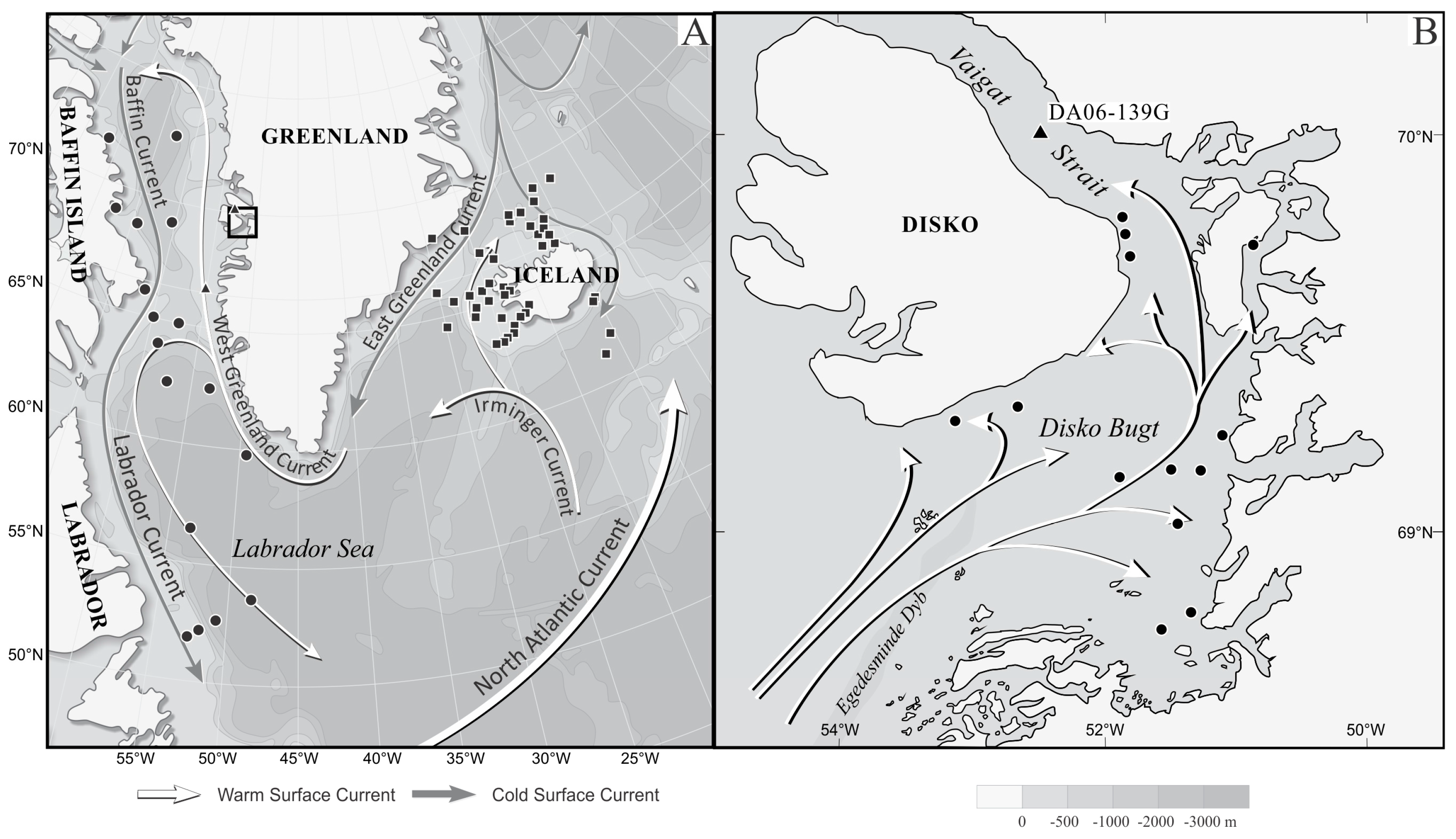
2. Oceanographic Setting
3. Materials and Methods
3.1. Palaeo-Records: Sediment Cores and Diatom Samples
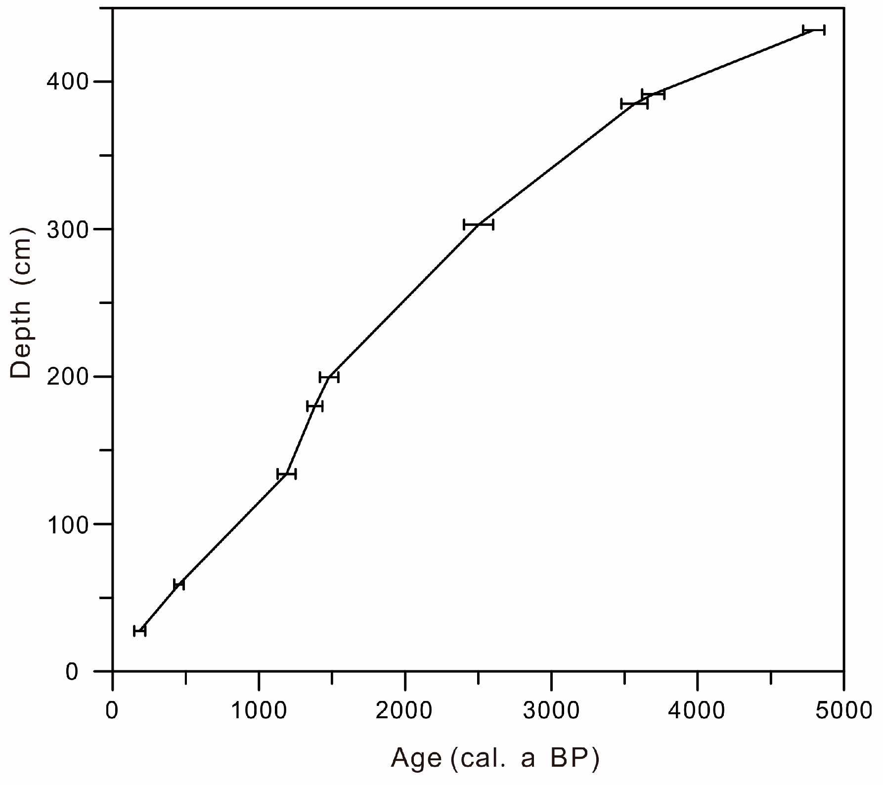
3.2. Age Model for the Sediment Core
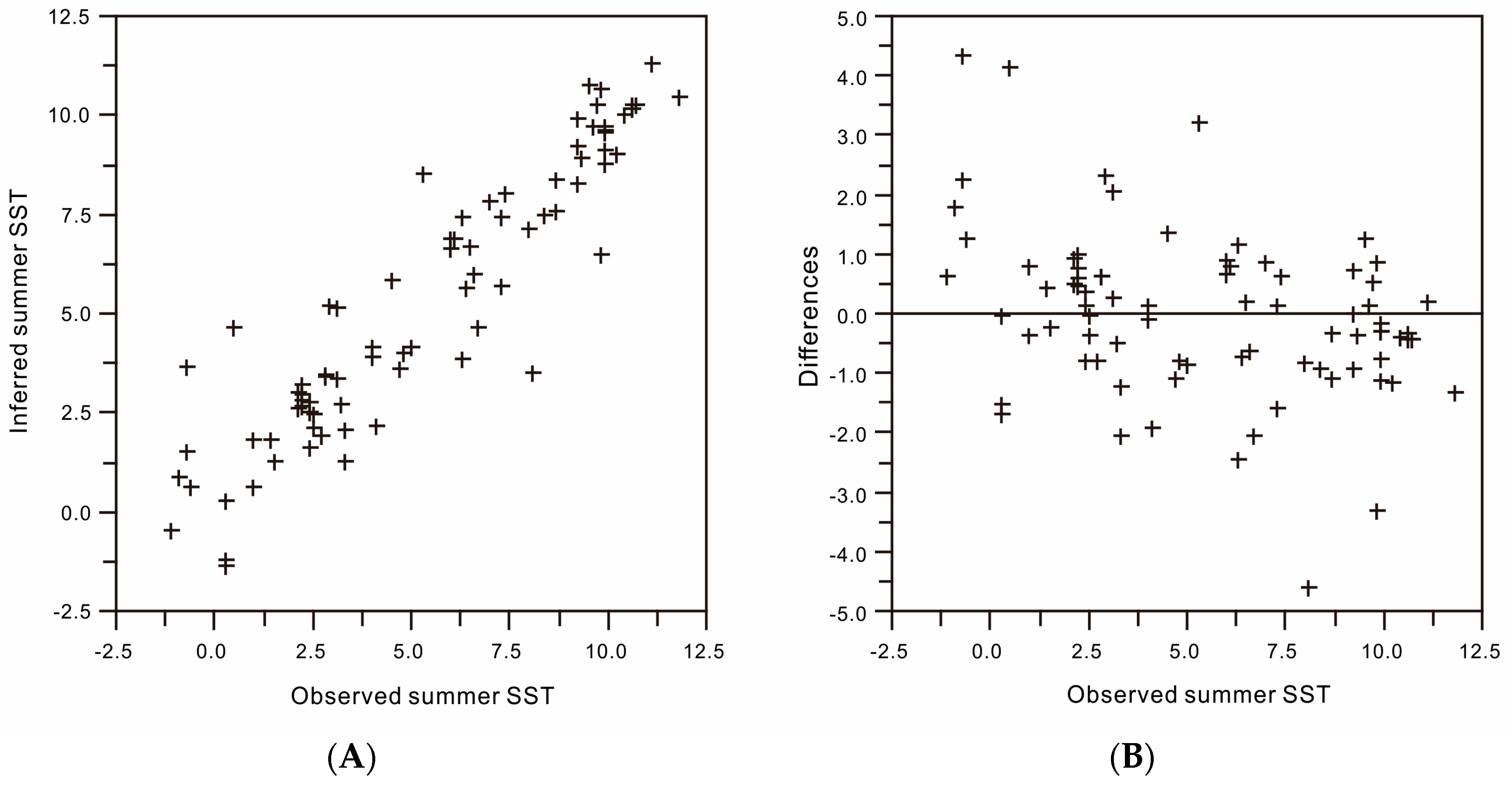
3.3. Modern Diatom Data Set and Diatom-Based Transfer Function
3.4. Statistical Analysis
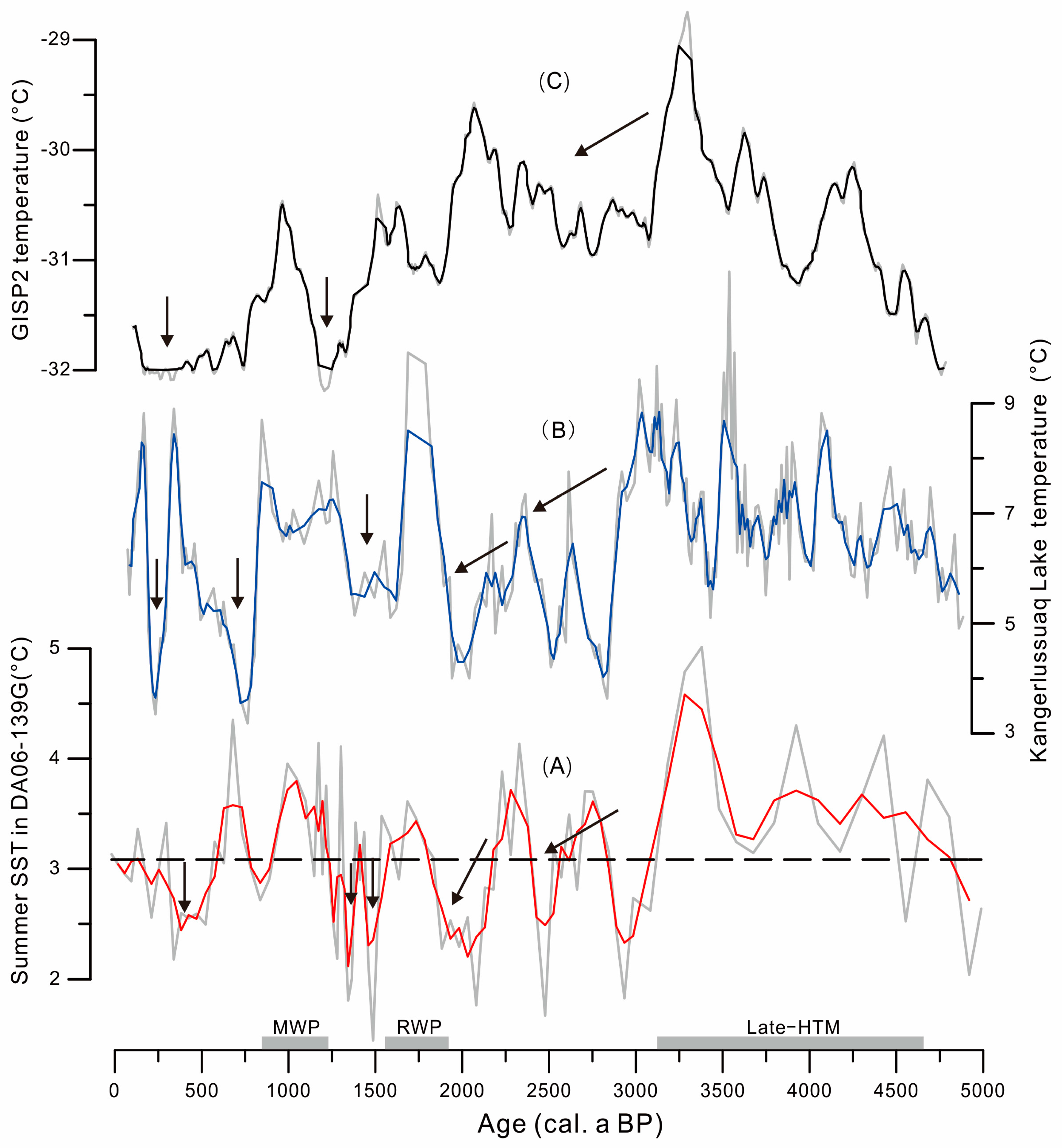
4. Results
5. Discussion
5.1. 5000–3000 cal. a BP: Late-Holocene Thermal Maximum
5.2. 3000–2000 cal. a BP: Neoglacial Cooling
5.3. After 2000 cal. a BP:
5.3.1. 2000–1600 cal. a BP: Roman Warm Period
5.3.2. 1500–1200 cal. a BP: Dark Ages Cold Period
5.3.3. 1200–630 cal. a BP: Medieval Climate Anomaly
5.3.4. After 630 cal. a BP: Little Ice Age
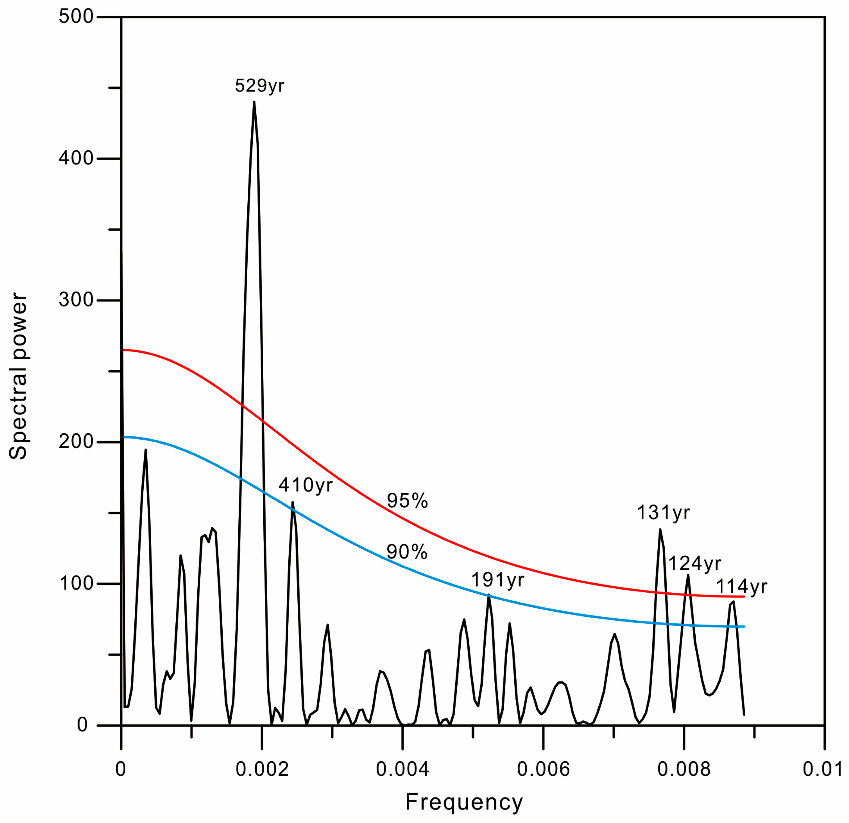
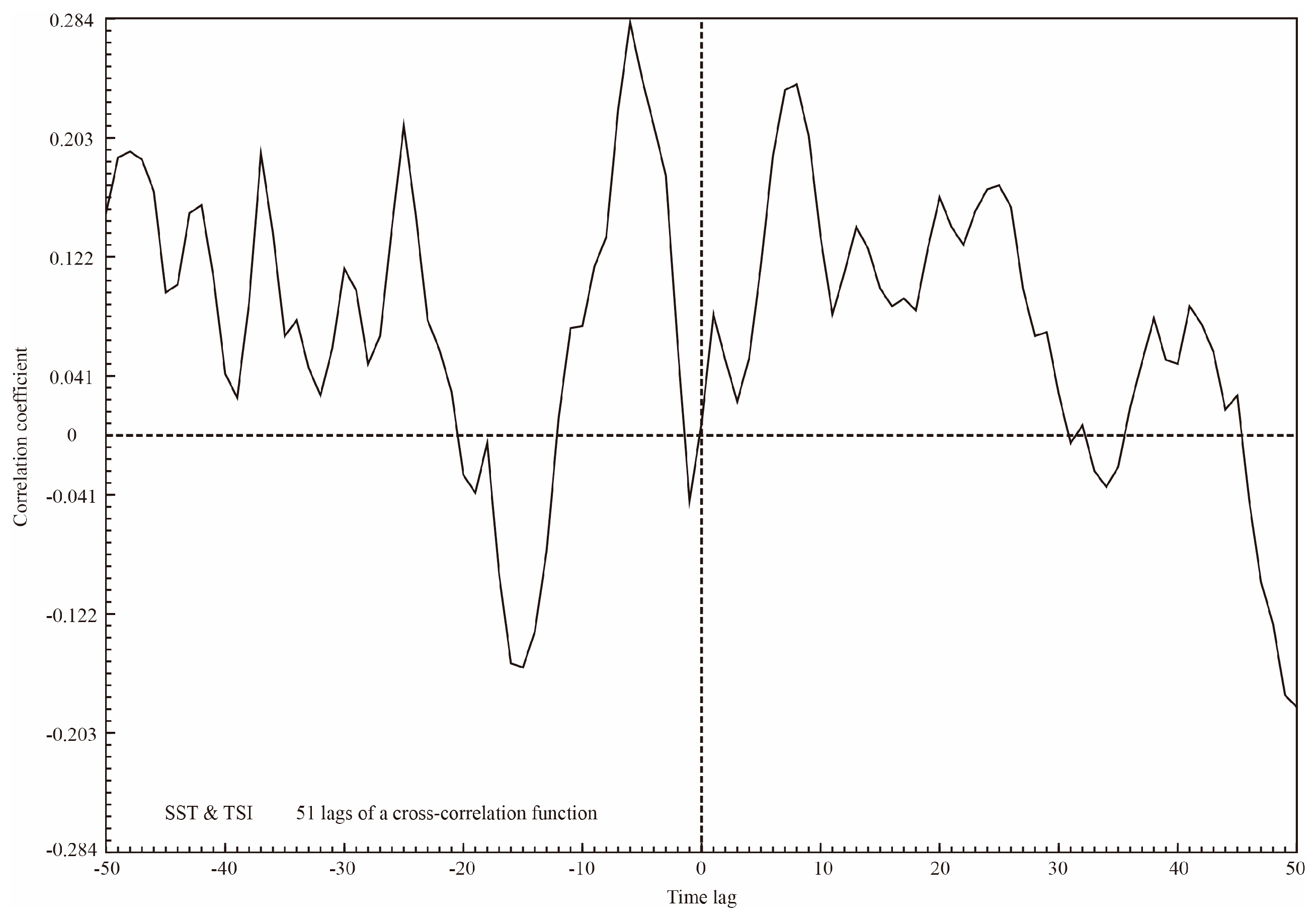
5.4. Links between SST Changes and Solar Activity
6. Conclusions
Supplementary Materials
Acknowledgments
Author Contributions
Conflicts of Interest
References
- Lloyd, J.M.; Park, L.A.; Kuijpers, A.; Moros, M. Early Holocene palaeoceanography and deglacial chronology of Disko Bugt, West Greenland. Quat. Sci. Rev. 2005, 24, 1741–1755. [Google Scholar] [CrossRef]
- Moros, M.; Jensen, K.G.; Kuijpers, A. Mid-to late-Holocene hydrological and climatic variability in Disko Bugt, central West Greenland. Holocene 2006, 16, 357–367. [Google Scholar] [CrossRef]
- Seidenkrantz, M.-S.; Roncaglia, L.; Fischel, A.; Moros, M. Variable North Atlantic climate seesaw patterns documented by a late Holocene marine record from Disko Bugt, West Greenland. Mar. Micropaleontol. 2008, 68, 66–83. [Google Scholar] [CrossRef]
- Krawczyk, D.W.; Witkowski, A.; Moros, M.; Lloyd, J.M.; Kuijpers, A.; Kierzek, A. Late-Holocene diatom-inferred reconstruction of temperature variations of the West Greenland Current from Disko Bugt, central West Greenland. Holocene 2010, 20, 659–666. [Google Scholar] [CrossRef]
- Joughin, I.; Abdalati, W.; Fahnestock, M. Large fluctuations in speed on Greenland’s Jakobshavn Isbræ glacier. Nature 2004, 432, 608–610. [Google Scholar] [CrossRef] [PubMed]
- Joughin, I. Greenland Rumbles Louder as Glaciers Accelerate. Science 2006, 311, 1719–1720. [Google Scholar] [CrossRef] [PubMed]
- Joughin, I.; Das, S.B.; King, M.A.; Smith, B.E.; Howat, I.M.; Moon, T. Seasonal speedup along the western flank of the Greenland ice sheet. Science 2008, 320, 781–783. [Google Scholar] [CrossRef] [PubMed]
- Rignot, E.; Kanagaratnam, P. Changes in the velocity structure of the Greenland Ice Sheet. Science 2006, 311, 986–990. [Google Scholar] [CrossRef] [PubMed]
- Moros, M.; Lloyd, J.M.; Perner, K.; Krawczyk, D.; Blanz, T.; de Vernal, A.; Ouellet-Bernier, M.M.; Kuijpers, A.; Jennings, A.E.; Witkowski, A.; et al. Surface and sub-surface multi-proxy reconstruction of middle to late Holocene palaeoceanographic changes in Disko Bugt, West Greenland. Quat. Sci. Rev. 2016, 132, 146–160. [Google Scholar] [CrossRef]
- Jensen, K.G.; Kuijpers, A.; Koç, N.; Heinemeier, J. Diatom evidence of hydrographic changes and ice conditions in Igaliku Fjord, South Greenland, during the past 1500 years. Holocene 2004, 14, 152–164. [Google Scholar] [CrossRef]
- Ren, J.; Jiang, H.; Seidenkrantz, M.-S.; Kuijpers, A. A diatom-based reconstruction of Early Holocene hydrographic and climatic change in a southwest Greenland fjord. Mar. Micropaleontol. 2009, 70, 166–176. [Google Scholar] [CrossRef]
- Berner, K.S.; Koç, N.; Divine, D.; Godtliebsen, F.; Moros, M. A decadal-scale Holocene sea surface temperature record from the subpolar North Atlantic constructed using diatoms and statistics and its relation to other climate parameters. Paleoceanography 2008, 23, PA2210. [Google Scholar] [CrossRef]
- Sicre, M.-A.; Hall, I.R.; Mignot, J.; Khodri, M.; Ezat, U.; Truong, M.X.; Eiríksson, J.; Knudsen, K.L. Sea surface temperature variability in the subpolar Atlantic over the last two millennia. Paleoceanography 2011, 26, PA4218. [Google Scholar] [CrossRef]
- Sicre, M.-A.; Weckström, K.; Seidenkrantz, M.S.; Kuijpers, A.; Benetti, M.; Masse, G.; Ezat, U.; Schmidt, S.; Bouloubassi, I.; Olsen, J.; et al. Labrador current variability over the last 2000 years. Earth Planet. Sci. Lett. 2014, 400, 26–32. [Google Scholar] [CrossRef]
- Jiang, H.; Eiríksson, J.; Schulz, M.; Knudsen, K.L.; Seidenkrantz, M.-S. Evidence for solar forcing of sea-surface temperature on the North Icelandic Shelf during the late Holocene. Geology 2005, 33, 73–76. [Google Scholar] [CrossRef]
- Jiang, H.; Muscheler, R.; Björck, S.; Seidenkrantz, M.-S.; Olsen, J.; Sha, L. Solar forcing of Holocene summer sea-surface temperatures in the northern North Atlantic. Geology 2015, 43, 203–206. [Google Scholar] [CrossRef]
- Sha, L.; Jiang, H.; Seidenkrantz, M.-S.; Knudsen, K.L.; Olsen, J.; Kuijpers, A.; Liu, Y. A diatom-based sea-ice reconstruction for the Vaigat Strait (Disko Bugt, West Greenland) over the last 5000 yr. Palaeogeogr. Palaeoclimatol. Palaeoecol. 2014, 403, 66–79. [Google Scholar] [CrossRef]
- Sha, L.; Jiang, H.; Seidenkrantz, M.-S.; Muscheler, R.; Zhang, X.; Knudsen, M.F.; Olsen, J.; Knudsen, K.L.; Zhang, W. Solar forcing as an important trigger for West Greenland sea-ice variability over the last millennium. Quat. Sci. Rev. 2016, 131, 148–156. [Google Scholar] [CrossRef]
- Ran, L.; Jiang, H.; Knudsen, K.L.; Eiríksson, J. Diatom-based reconstruction of palaeoceanographic changes on the North Icelandic shelf during the last millennium. Palaeogeogr. Palaeoclimatol. Palaeoecol. 2011, 302, 109–119. [Google Scholar] [CrossRef]
- Rigual-Hernández, A.S.; Colmenero-Hidalgo, E.; Martrat, B.; Bárcena, M.A.; de Vernal, A.; Sierro, F.J.; Flores, J.A.; Grimalt, J.O.; Henry, M.; Lucchi, R.G. Svalbard ice-sheet decay after the Last Glacial Maximum: New insights from micropalaeontological and organic biomarker paleoceanographical reconstructions. Palaeogeogr. Palaeoclimatol. Palaeoecol. 2017, 465, 225–236. [Google Scholar] [CrossRef]
- Carbonara, K.; Mezgec, K.; Varagona, G.; Musco, M.E.; Lucchi, R.G.; Villa, G.; Morigi, C.; Melis, R.; Caffau, M. Palaeoclimatic changes in Kveithola, Svalbard, during the Late Pleistocene deglaciation and Holocene: Evidences from microfossil and sedimentary records. Palaeogeogr. Palaeoclimatol. Palaeoecol. 2016, 463, 136–149. [Google Scholar] [CrossRef]
- Berner, K.S.; Koç, N.; Godtliebsen, F.; Divine, D.V. Holocene climate variability of the Norwegian Atlantic Current during high and low solar insolation forcing. Paleoceanography 2011, 26, 252–257. [Google Scholar] [CrossRef]
- Miettinen, A.; Divine, D.; Koç, N.; Godtliebsen, F.; Hall, I.R. Multicentennial Variability of the Sea Surface Temperature Gradient across the Subpolar North Atlantic over the Last 2.8 kyr. J. Clim. 2012, 25, 4205–4219. [Google Scholar] [CrossRef]
- Miettinen, A.; Divine, D.; Husum, K.; Koç, N.; Jennings, A.E. Exceptional ocean surface conditions on the SE Greenland shelf during the Medieval Climate Anomaly. Paleoceanography 2015, 30, 1657–1674. [Google Scholar] [CrossRef]
- Hasle, G.R.; Syvertsen, E.E. Marine diatoms. In Identifying Marine Phytoplankton; Tomas, C.R., Ed.; Academic Press Inc.: San Diego, CA, USA, 1997; pp. 5–385. [Google Scholar]
- Von Quillfeldt, C.H. Identification of Some Easily Confused Common Diatom Species in Arctic Spring Blooms. Bot. Mar. 2001, 44, 375–389. [Google Scholar] [CrossRef]
- Arrigo, K.R.; Perovich, D.K.; Pickart, R.S.; Brown, Z.W.; van Dijken, G.L.; Lowry, K.E.; Mills, M.M.; Palmer, M.A.; Balch, W.M.; Bahr, F.; et al. Massive phytoplankton blooms under Arctic sea ice. Science 2012, 336, 1408. [Google Scholar] [CrossRef] [PubMed]
- Jiang, H.; Seidenkrantz, M.-S.; Knudsen, K.L.; Eirı́ksson, J. Diatom surface sediment assemblages around Iceland and their relationships to oceanic environmental variables. Mar. Micropaleontol. 2001, 41, 73–96. [Google Scholar] [CrossRef]
- Andersen, C. Nonuniform response of the major surface currents in the Nordic Seas to insolation forcing: Implications for the Holocene climate variability. Paleoceanography 2004, 19, 1–16. [Google Scholar] [CrossRef]
- Andersen, C.; Koç, N.; Moros, M. A highly unstable Holocene climate in the subpolar North Atlantic: Evidence from diatoms. Quat. Sci. Rev. 2004, 23, 2155–2166. [Google Scholar] [CrossRef]
- Krawczyk, D.W.; Witkowski, A.; Moros, M.; Lloyd, J.M.; Høyer, J.L.; Miettinen, A.; Kuijpers, A. Quantitative reconstruction of Holocene sea ice and sea surface temperature off West Greenland from the first regional diatom data set. Paleoceanography 2017, 31, 18–40. [Google Scholar] [CrossRef]
- Steinhilber, F.; Beer, J.; Fröhlich, C. Total solar irradiance during the Holocene. Geophys. Res. Lett. 2009, 36, LP19704. [Google Scholar] [CrossRef]
- Kodera, K.; Kuroda, Y. Dynamical response to the solar cycle. J. Geophys. Res. 2002, 107, ACL 5-1–ACL 5-12. [Google Scholar] [CrossRef]
- Ruzmaikin, A.; Feynman, J.; Jiang, X.; Noone, D.C.; Waple, A.M.; Yung, Y.L. The pattern of northern hemisphere surface air temperature during prolonged periods of low solar output. Geophys. Res. Lett. 2004, 31, 261–268. [Google Scholar] [CrossRef]
- Haigh, J.D.; Roscoe, H.K. Solar influences on polar modes of variability. Meteorol. Z. 2006, 15, 371–378. [Google Scholar] [CrossRef]
- Hodell, D.A.; Kanfoush, S.L.; Shemesh, A.; Crosta, X.; Charles, C.D.; Guilderson, T.P. Abrupt Cooling of Antarctic Surface Waters and Sea Ice Expansion in the South Atlantic Sector of the Southern Ocean at 5000 cal yr B.P. Quat. Res. 2001, 56, 191–198. [Google Scholar] [CrossRef]
- Knudsen, M.F.; Jacobsen, B.H.; Seidenkrantz, M.-S.; Olsen, J. Evidence for external forcing of the Atlantic Multidecadal Oscillation since termination of the Little Ice Age. Nat. Commun. 2014, 5, 3323. [Google Scholar] [CrossRef] [PubMed]
- Marchitto, T.M.; Muscheler, R.; Ortiz, J.D.; Carriquiry, J.D.; van Geen, A. Dynamical Response of the Tropical Pacific Ocean to Solar Forcing During the Early Holocene. Science 2010, 330, 1378–1381. [Google Scholar] [CrossRef] [PubMed]
- Martin-Puertas, C.; Matthes, K.; Brauer, A.; Muscheler, R.; Hansen, F.; Petrick, C.; Aldahan, A.; Possnert, G.; van Geel, B. Regional atmospheric circulation shifts induced by a grand solar minimum. Nat. Geosci. 2012, 5, 397–401. [Google Scholar] [CrossRef]
- Verschuren, D.; Laird, K.R.; Cumming, B.F. Rainfall and drought in equatorial east Africa during the past 1100 years. Nature 2000, 403, 410–414. [Google Scholar] [CrossRef] [PubMed]
- Bond, G.; Kromer, B.; Beer, J.; Muscheler, R.; Evans, M.N.; Showers, W.; Hoffmann, S.; Lotti-Bond, R.; Hajdas, I.; Bonani, G. Persistent solar influence on North Atlantic climate during the Holocene. Science 2001, 294, 2130–2136. [Google Scholar] [CrossRef] [PubMed]
- Holzhauser, H.; Magny, M.J.; Zumbuuhl, H.J. Glacier and lake-level variations in west-central Europe over the last 3500 years. Holocene 2005, 15, 789–801. [Google Scholar] [CrossRef]
- Sejrup, H.P.; Lehman, S.J.; Haflidason, H.; Noone, D.; Muscheler, R.; Berstad, I.M.; Andrews, J.T. Response of Norwegian Sea temperature to solar forcing since 1000 A.D. J. Geophys. Res. 2010, 115, 168–172. [Google Scholar] [CrossRef]
- Long, A.J.; Roberts, D.H. Late Weichselian deglacial history of Disko Bugt, West Greenland, and the dynamics of the Jakobshavns Isbrae ice stream. Boreas 2003, 32, 208–226. [Google Scholar] [CrossRef]
- Andresen, C.S.; McCarthy, D.; Valdemar Dylmer, C.; Lloyd, J.M. Interaction between subsurface ocean waters and calving of the Jakobshavn Isbræ during the late Holocene. Holocene 2011, 21, 211–224. [Google Scholar] [CrossRef]
- Weidick, A.; Bennike, O. Quaternary glaciation history and glaciology of Jakobshavn Isbræ and the Disko Bugt region, West Greenland: A review. Geol. Surv. Den. Greenl. 2007, 14, 78. [Google Scholar]
- Buch, E. Review of oceanographic conditions in subarea 0 and 1 during the 1970–79 decade. NAFO Sci. Coun. Stud. 1982, 5, 43–50. [Google Scholar]
- Tang, C.C.L.; Ross, C.K.; Yao, T.; Petrie, B.; DeTracey, B.M.; Dunlap, E. The circulation, water masses and sea-ice of Baffin Bay. Prog. Oceanogr. 2004, 63, 183–228. [Google Scholar] [CrossRef]
- Andersen, O.G.N. The annual cycle of phytoplankton primary production and hydrography in the Disko Bugt area, West Greenland. Meddelelser om Grønland Biosci. 1981, 6, 68. [Google Scholar]
- Dalhoff, F.; Kuijpers, A. Havbunds Prøveindsamling ud for Vest Grønland 2006. RV Dana Cruise Report; Danmarks og Grønlands Geologiske Undersøgelse: Copenhagen, Denmark, 2007. [Google Scholar]
- Håkansson, H. The recent diatom succession of Lake Havgårdssjön, South Sweden. In Proceedings of the Seventh International Diatom Symposium, Philadelphia, PA, USA, 22–27 August 1982; Mann, D.G., Ed.; Otto Koeltz Science Publishers: Koenigstein, Germany, 1984; pp. 411–429. [Google Scholar]
- Koç Karpuz, N.; Schrader, H. Surface sediment diatom distribution and Holocene paleotemperature variations in the Greenland, Iceland and Norwegian Sea. Paleoceanography 1990, 5, 557–580. [Google Scholar] [CrossRef]
- Cremer, H. Distribution patterns of diatom surface sediment assemblages in the Laptev Sea (Arctic Ocean). Mar. Micropaleontol. 1999, 38, 39–67. [Google Scholar] [CrossRef]
- Ramsey, C.B. Deposition models for chronological records. Quat. Sci. Rev. 2008, 27, 42–60. [Google Scholar] [CrossRef]
- Reimer, P.J.; Baillie, M.G.L.; Bard, E.; Bayliss, A.; Beck, J.W.; Blackwell, P.G.; Bronk Ramsey, C.; Buck, C.E.; Burr, G.S.; Edwards, R.L.; et al. IntCal09 and Marine09 radiocarbon age calibration curves, 0–50,000 years cal BP. Radiocarbon 2009, 51, 1111–1150. [Google Scholar] [CrossRef]
- McNeely, R.; Dyke, A.S.; Southon, J.R. Canadian Marine Reservoir Ages, Preliminary Data Assessment, Open File 5049: 3. Geological Survey Canada [WWW Document]. Available online: http://geopub.nrcan.gc.ca (accessed on 27 April 2017).
- Lloyd, J.M.; Moros, M.; Perner, K.; Telford, R.J.; Kuijpers, A.; Jansen, E.; McCarthy, D. A 100 years record of ocean temperature control on the stability of Jakobshavn Isbrae, West Greenland. Geology 2011, 39, 867–870. [Google Scholar] [CrossRef]
- Juggins, S. C2 User Guide: Software for Ecological and Palaeoecological Data Analysis and Visualisation, Version 1.5; Newcastle University: Newcastle upon Tyne, UK, 2003. [Google Scholar]
- Schulz, M. REDFIT: Estimating red-noise spectra directly from unevenly spaced paleoclimatic time series. Comput. Geosci. 2002, 28, 421–426. [Google Scholar] [CrossRef]
- Howell, P.; Pisias, N.; Balance, J.; Baughman, J.; Ochs, L. ARAND Time-Series Analysis Software; Brown University: Providence, RI, USA, 2006. [Google Scholar]
- D′Andrea, W.J.; Huang, Y.; Fritz, S.C.; Anderson, N.J. Abrupt Holocene climate change as an important factor for human migration in West Greenland. Proc. Natl. Acad. Sci. USA 2011, 108, 9765–9769. [Google Scholar]
- Alley, R.B. GISP2 Ice Core Temperature and Accumulation Data; National Oceanic and Atmospheric Administration/National Geophysical Data Center Paleoclimatology Program: Boulder, CO, USA, 2004. [Google Scholar]
- Stuiver, M.; Braziunas, T.F. Sun, ocean, climate and atmospheric 14CO2: An evaluation of causal and spectral relationships. Holocene 1993, 3, 289–305. [Google Scholar] [CrossRef]
- Kaufman, D.S.; Ager, T.A.; Anderson, N.J.; Wolfe, B.B. Holocene thermal maximum in the western Arctic (0–180°W). Quat. Sci. Rev. 2004, 23, 529–560. [Google Scholar] [CrossRef]
- Kaplan, M.R.; Wolfe, A.P.; Miller, G.H. Holocene environmental variability in Southern Greenland inferred from lake sediments. Quat. Res. 2002, 58, 149–159. [Google Scholar] [CrossRef]
- Meldgaard, M. Ancient Harp Seal hunters of Disko Bay. Subsistence and settlement at the Saqqaq culture site Qeqertasussuk (2400/1400 BC), West Greenland. Meddelelser om Grønland Man Soc. 2004, 30, 189. [Google Scholar]
- Jennings, A.E.; Knudsen, K.L.; Hald, M.; Hansen, C.V.; Andrews, J.T. A mid-Holocene shift in Arctic sea-ice variability on the East Greenland Shelf. Holocene 2002, 12, 49–58. [Google Scholar] [CrossRef]
- Jiang, H.; Seidenkrantz, M.-S.; Knudsen, K.L.; Eiríksson, J. Late-Holocene summer sea-surface temperatures based on a diatom record from the north Icelandic shelf. Holocene 2002, 12, 137–147. [Google Scholar] [CrossRef]
- Porter, S.C.; Denton, G.H. Chronology of neoglaciation in the North American Cordillera. Am. J. Sci. 1967, 265, 177–210. [Google Scholar] [CrossRef]
- Lloyd, J.M.; Kuijpers, A.; Long, A.; Moros, M.; Park, L.A. Foraminiferal reconstruction of mid- to late-Holocene ocean circulation and climate variability in Disko Bugt, West Greenland. Holocene 2007, 17, 1079–1091. [Google Scholar] [CrossRef]
- Seidenkrantz, M.-S.; Aagaard-Sørensen, S.; Sulsbrück, H.; Kuijpers, A.; Jensen, K.G.; Kunzendorf, H. Hydrography and climate of the last 4400 years in a SW Greenland fjord: Implications for Labrador Sea palaeoceanography. Holocene 2007, 17, 387–401. [Google Scholar] [CrossRef]
- Andrews, J.T.; Caseldine, C.; Weiner, N.J.; Hatton, J. Late Holocene (ca. 4 ka) marine and terrestrial environmental change in Reykjarfjördur, north Iceland: Climate and/or settlement? J. Quat. Sci. 2001, 16, 133–143. [Google Scholar] [CrossRef]
- Justwan, A.; Koç, N.; Jennings, A.E. Evolution of the Irminger and East Icelandic Current systems through the Holocene, revealed by diatom-based sea surface temperature reconstructions. Quat. Sci. Rev. 2008, 27, 1571–1582. [Google Scholar] [CrossRef]
- Mudie, P.J.; Rochon, A.; Levac, E. Decadal-scale sea ice changes in the Canadian Arctic and their impacts on humans during the past 4000 years. Environ. Archaeol. 2005, 10, 113–126. [Google Scholar] [CrossRef]
- Mudie, P.J.; Rochon, A.; Prins, M.A.; Soenarjo, D.; Troelstra, S.R.; Levac, E.; Scott, D.B.; Roncaglia, L.; Kuijpers, A. Late Pleistocene-Holocene marine geology of Nares Strait Region: Palaeoceanography from foraminifera and dinoflagellate cysts, sedimentology and stable. Polarforschung 2006, 74, 169–183. [Google Scholar]
- Moros, M.; Jansen, E.; Oppo, D.W.; Giraudeau, J.; Kuijpers, A. Reconstruction of the late-Holocene changes in the Sub-Arctic Front position at the Reykjanes Ridge, north Atlantic. Holocene 2012, 22, 877–886. [Google Scholar] [CrossRef]
- Andrews, J.T.; Giraudeau, J. Multi-proxy records showing significant Holocene environmental variability: The inner N. Iceland shelf (Húnaflói). Quat. Sci. Rev. 2003, 22, 175–193. [Google Scholar] [CrossRef]
- Risebrobakken, B.; Jansen, E.; Andersson, C.; Mjelde, E.; Hevrøy, K. A high-resolution study of Holocene paleoclimatic and paleoceanographic changes in the Nordic Seas. Paleoceanography 2003, 18, 123–126. [Google Scholar] [CrossRef]
- Sarnthein, M.; van Kreveld, S.; Erlenkeuser, H.; Grootes, P.M.; Kucera, M.; Pflaumann, U.; Schulz, M. Centennial-to-millennial-scale periodicities of Holocene climate and sediment injections off the western Barents shelf, 75°N. Boreas 2003, 32, 447–461. [Google Scholar] [CrossRef]
- Bakke, J.; Lie, Ø.; Dahl, S.O.; Nesje, A.; Bjune, A.E. Strength and spatial patterns of the Holocene wintertime westerlies in the NE Atlantic region. Glob. Planet. Chang. 2008, 60, 28–41. [Google Scholar] [CrossRef]
- Lamb, H.H. Climate, History and the Modern World; Routledge: New York, NY, USA, 1995. [Google Scholar]
- Mann, M.E.; Zhang, Z.; Rutherford, S.; Bradley, R.S.; Hughes, M.K.; Shindell, D.; Ammann, C.; Faluvegi, G.; Ni, F. Global signatures and dynamical origins of the Little Ice Age and Medieval Climate Anomaly. Science 2009, 326, 1256–1260. [Google Scholar] [CrossRef] [PubMed]
- Sha, L.; Jiang, H.; Knudsen, K.L. Diatom evidence of climatic change in Holsteinsborg Dyb, west of Greenland, during the last 1200 years. Holocene 2012, 22, 347–358. [Google Scholar] [CrossRef]
- Roncaglia, L.; Kuijpers, A. Palynofacies analysis and organic-walled dinoflagellate cysts in late-Holocene sediments from Igaliku Fjord, South Greenland. Holocene 2004, 14, 172–184. [Google Scholar] [CrossRef]
- Jennings, A.E.; Weiner, N.J. Environmental change in eastern Greenland during the last 1300 years: Evidence from foraminifera and lithologies in Nansen Fjord, 68°N. Holocene 1996, 6, 179–191. [Google Scholar] [CrossRef]
- Eiríksson, J.; Knudsen, K.L.; Haflidason, H.; Henriksen, P. Late-glacial and Holocene palaeoceanography of the North Icelandic shelf. J. Quat. Sci. 2000, 15, 23–42. [Google Scholar] [CrossRef]
- Knudsen, K.L.; Eiríksson, J.; Jansen, E.; Jiang, H.; Rytter, F.; Gudmundsdóttir, E.R. Palaeoceanographic changes off North Iceland through the last 1200 years: Foraminifera, stable isotopes, diatoms and ice rafted debris. Quat. Sci. Rev. 2004, 23, 2231–2246. [Google Scholar] [CrossRef]
- Knudsen, K.L.; Eiríksson, J.; Bartels-Jónsdóttir, H.B. Oceanographic changes through the last millennium off North Iceland: Temperature and salinity reconstructions based on foraminifera and stable isotopes. Mar. Micropaleontol. 2012, 84, 54–73. [Google Scholar] [CrossRef]
- LeBlanc, M.; Gajewski, K.; Hamilton, P.B. A diatom-based Holocene palaeoenvironmental record from a mid-arctic lake on Boothia Peninsula, Nunavut, Canada. Holocene 2004, 14, 417–425. [Google Scholar] [CrossRef]
- Grove, J.M. The Little Ice Age; Routledge: New York, NY, USA, 1988. [Google Scholar]
- Grove, J.M. The initiation of the “Little Ice Age” in regions round the North Atlantic. Clim. Chang. 2001, 48, 53–82. [Google Scholar] [CrossRef]
- Broecker, W.S. Was a change in thermohaline circulation responsible for the Little Ice Age? Proc. Natl. Acad. Sci. USA 2000, 97, 1339–1342. [Google Scholar] [CrossRef] [PubMed]
- Mayewski, P.A.; Rohling, E.E.; Stager, J.C.; Maasch, K.A.; Meeker, L.D.; Meyerson, E.A.; Gasse, F.; Kreveld, S.V.; Holmogren, K.; Lee-Thorp, J.; et al. Holocene climate variability. Quat. Res. 2004, 62, 243–255. [Google Scholar] [CrossRef]
- Dahl-Jensen, D.; Mosegaard, K.; Gundestrup, N.; Clow, G.D.; Johnsen, S.J.; Hansen, A.W.; Balling, N. Past temperatures directly from the Greenland Ice Sheet. Science 1998, 282, 268–271. [Google Scholar] [CrossRef] [PubMed]
- Lloyd, J.M. Late Holocene environmental change in Disko Bugt, west Greenland: Interaction between climate, ocean circulation and Jakobshavn Isbrae. Boreas 2006, 35, 35–49. [Google Scholar] [CrossRef]
- Wagner, B.; Melles, M.; Hahne, J.; Niessen, F.; Hubberten, H.-W. Holocene climate history of Geographical Society Ø, East Greenland-evidence from lake sediments. Palaeogeogr. Palaeoclimatol. Palaeoecol. 2000, 160, 45–68. [Google Scholar] [CrossRef]
- Bianchi, G.G.; McCave, I.N. Holocene periodicity in North Atlantic climate and deep-ocean flow south of Iceland. Nature 1999, 397, 515–517. [Google Scholar] [CrossRef]
- Moffa-Sánchez, P.; Born, A.; Hall, I.R.; Thornalley, D.J.R.; Barker, S. Solar forcing of North Atlantic surface temperature and salinity over the past millennium. Nat. Geosci. 2014, 7, 275–278. [Google Scholar] [CrossRef]


| Max_Bias | R2(Jack) | RMSEP(Jack) | ||
|---|---|---|---|---|
| WA | Inverse | 2.539 | 0.836 | 1.471 |
| WA(tol) | Inverse | 3.420 | 0.796 | 1.638 |
| WA | Classical | 1.932 | 0.837 | 1.538 |
| WA(tol) | Classical | 2.942 | 0.797 | 1.716 |
| PLS | 1 component | 2.376 | 0.641 | 2.173 |
| PLS | 2 components | 2.904 | 0.765 | 1.759 |
| PLS | 3 components | 2.897 | 0.796 | 1.641 |
| PLS | 4 components | 2.694 | 0.819 | 1.543 |
| PLS | 5 components | 2.412 | 0.841 | 1.444 |
| WA-PLS | 1 component | 2.540 | 0.836 | 1.470 |
| WA-PLS | 2 components | 2.047 | 0.853 | 1.393 |
| WA-PLS | 3 components | 2.201 | 0.860 | 1.355 |
| WA-PLS | 4 components | 2.072 | 0.862 | 1.346 |
| WA-PLS | 5 components | 2.084 | 0.855 | 1.383 |
| MAT | 1 analogue | 2.740 | 0.816 | 1.610 |
| MAT | 2 analogues | 1.720 | 0.852 | 1.443 |
| MAT | 3 analogues | 2.280 | 0.845 | 1.467 |
| MAT | 4 analogues | 2.555 | 0.849 | 1.452 |
| MAT | 5 analogues | 2.460 | 0.841 | 1.489 |
© 2017 by the authors. Licensee MDPI, Basel, Switzerland. This article is an open access article distributed under the terms and conditions of the Creative Commons Attribution (CC BY) license (http://creativecommons.org/licenses/by/4.0/).
Share and Cite
Li, D.; Sha, L.; Li, J.; Jiang, H.; Liu, Y.; Wu, Y. Summer Sea-Surface Temperatures and Climatic Events in Vaigat Strait, West Greenland, during the Last 5000 Years. Sustainability 2017, 9, 704. https://doi.org/10.3390/su9050704
Li D, Sha L, Li J, Jiang H, Liu Y, Wu Y. Summer Sea-Surface Temperatures and Climatic Events in Vaigat Strait, West Greenland, during the Last 5000 Years. Sustainability. 2017; 9(5):704. https://doi.org/10.3390/su9050704
Chicago/Turabian StyleLi, Dongling, Longbin Sha, Jialin Li, Hui Jiang, Yanguang Liu, and Yanni Wu. 2017. "Summer Sea-Surface Temperatures and Climatic Events in Vaigat Strait, West Greenland, during the Last 5000 Years" Sustainability 9, no. 5: 704. https://doi.org/10.3390/su9050704
APA StyleLi, D., Sha, L., Li, J., Jiang, H., Liu, Y., & Wu, Y. (2017). Summer Sea-Surface Temperatures and Climatic Events in Vaigat Strait, West Greenland, during the Last 5000 Years. Sustainability, 9(5), 704. https://doi.org/10.3390/su9050704