Development of an Evapotranspiration Data Assimilation Technique for Streamflow Estimates: A Case Study in a Semi-Arid Region


Abstract
1. Introduction
2. Soil and Water Assessment Tool (SWAT)
3. Gridded SWAT (GSWAT)
3.1. Data Gridded
3.2. Model Gridded
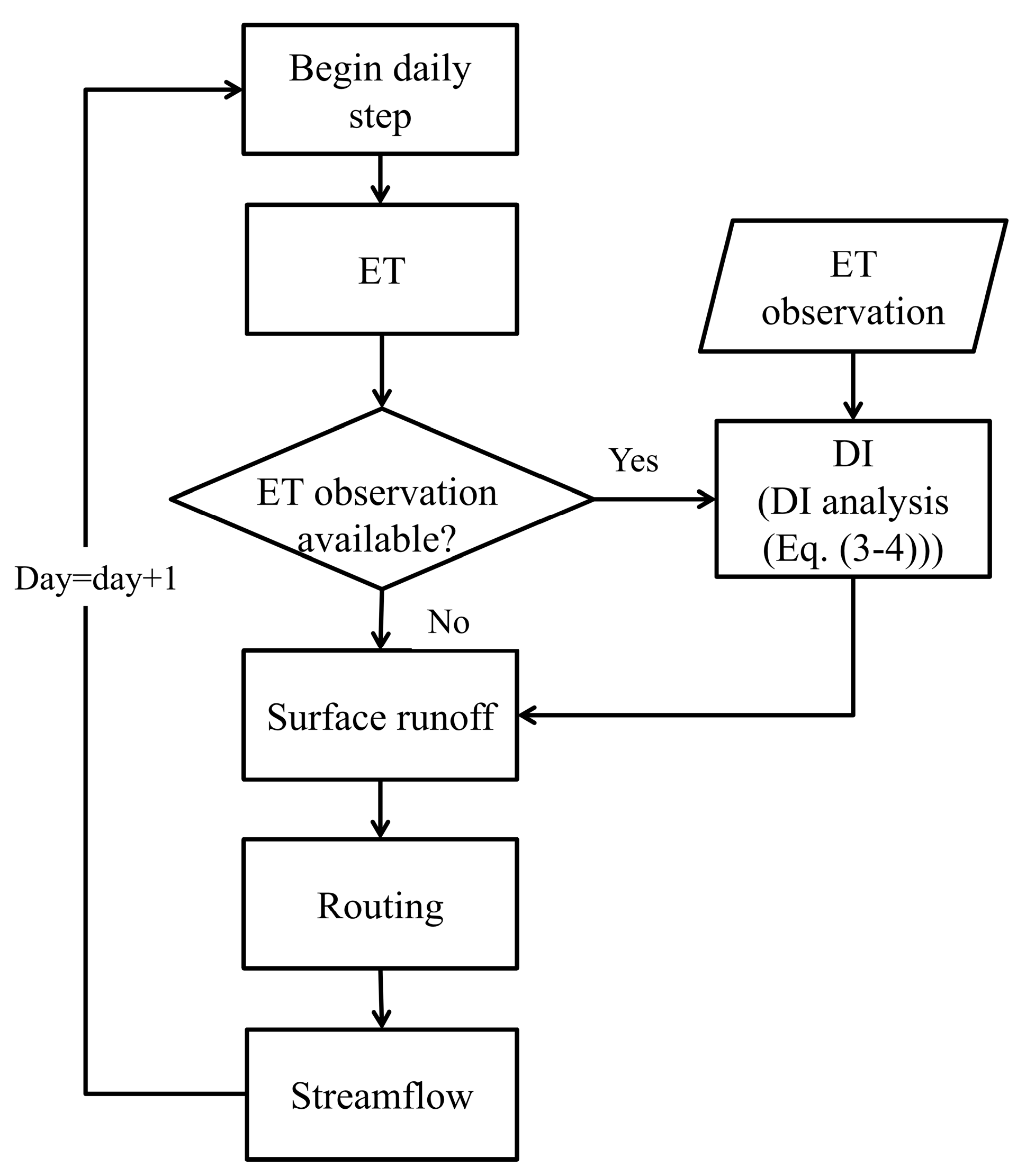
4. Implementation of Data Assimilation Technique
4.1. State Augmentation Direct Insertion Data Assimilation
4.2. Implementation Procedures
5. Case Study
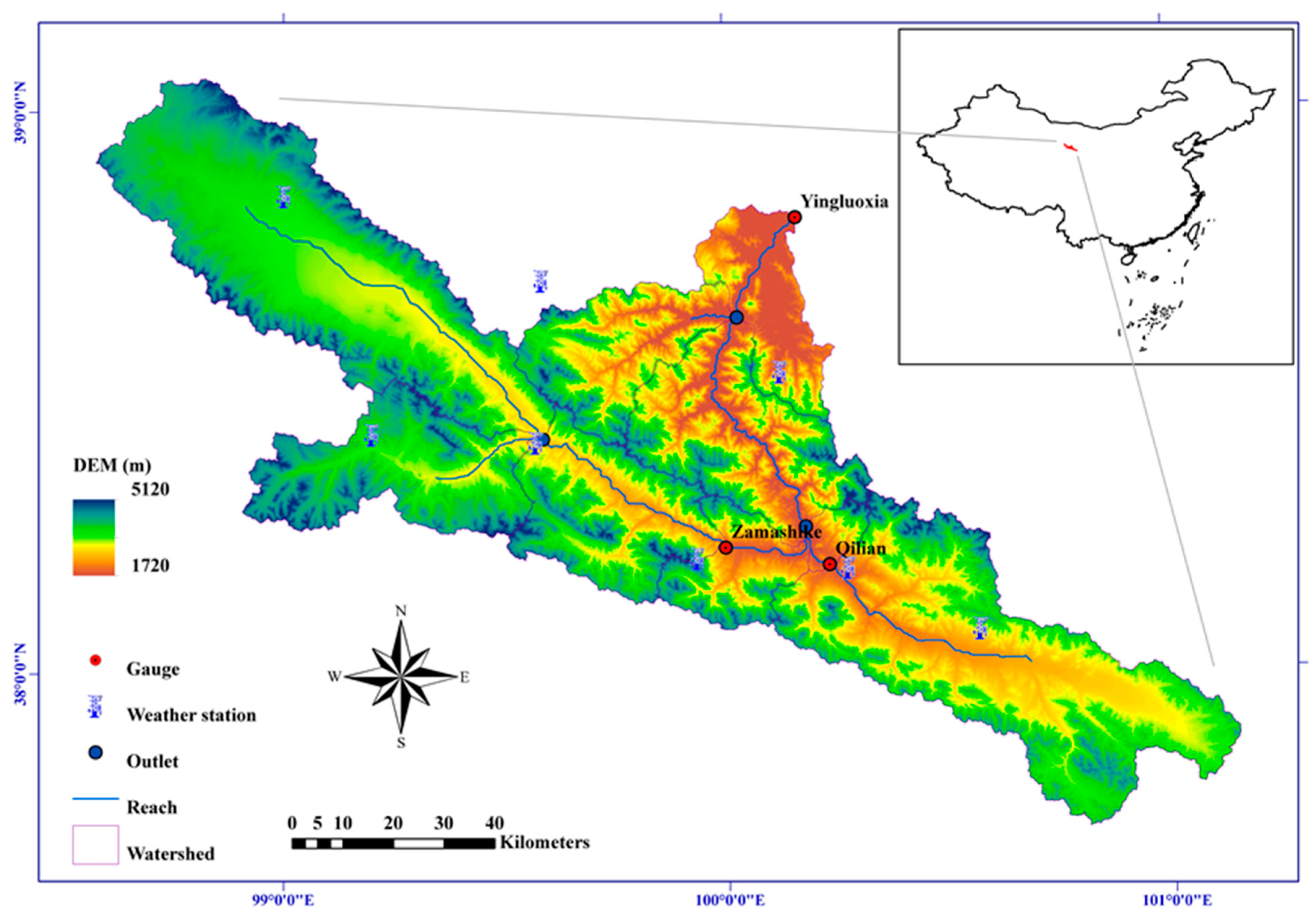
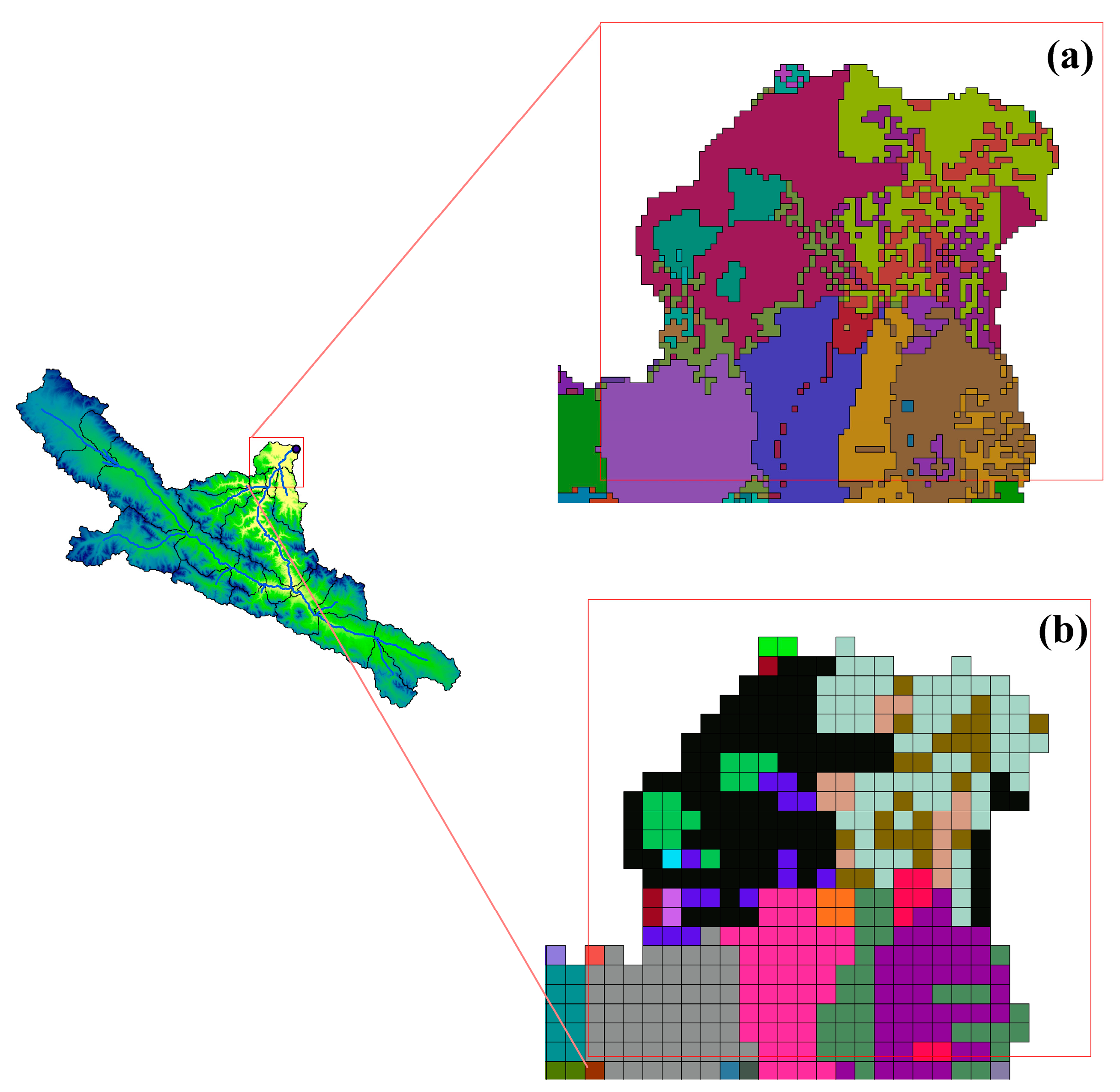
5.1. Study Area and Data
5.2. Hydrological Modeling Scheme
5.3. ET Data Assimilation Scheme
5.3.1. Synthetic Experiment Design
5.3.2. Real Data Experiment Design
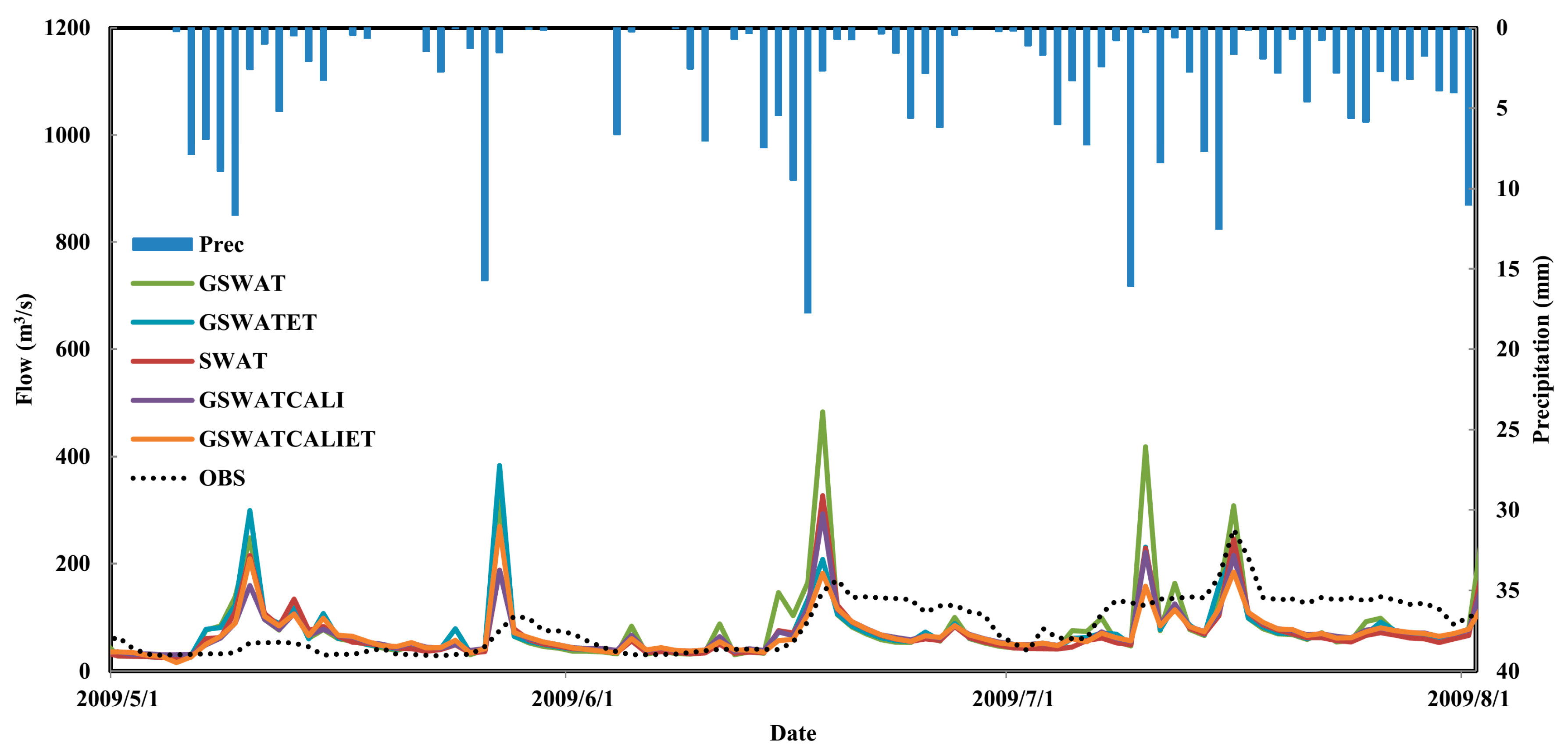
6. Results and Discussion
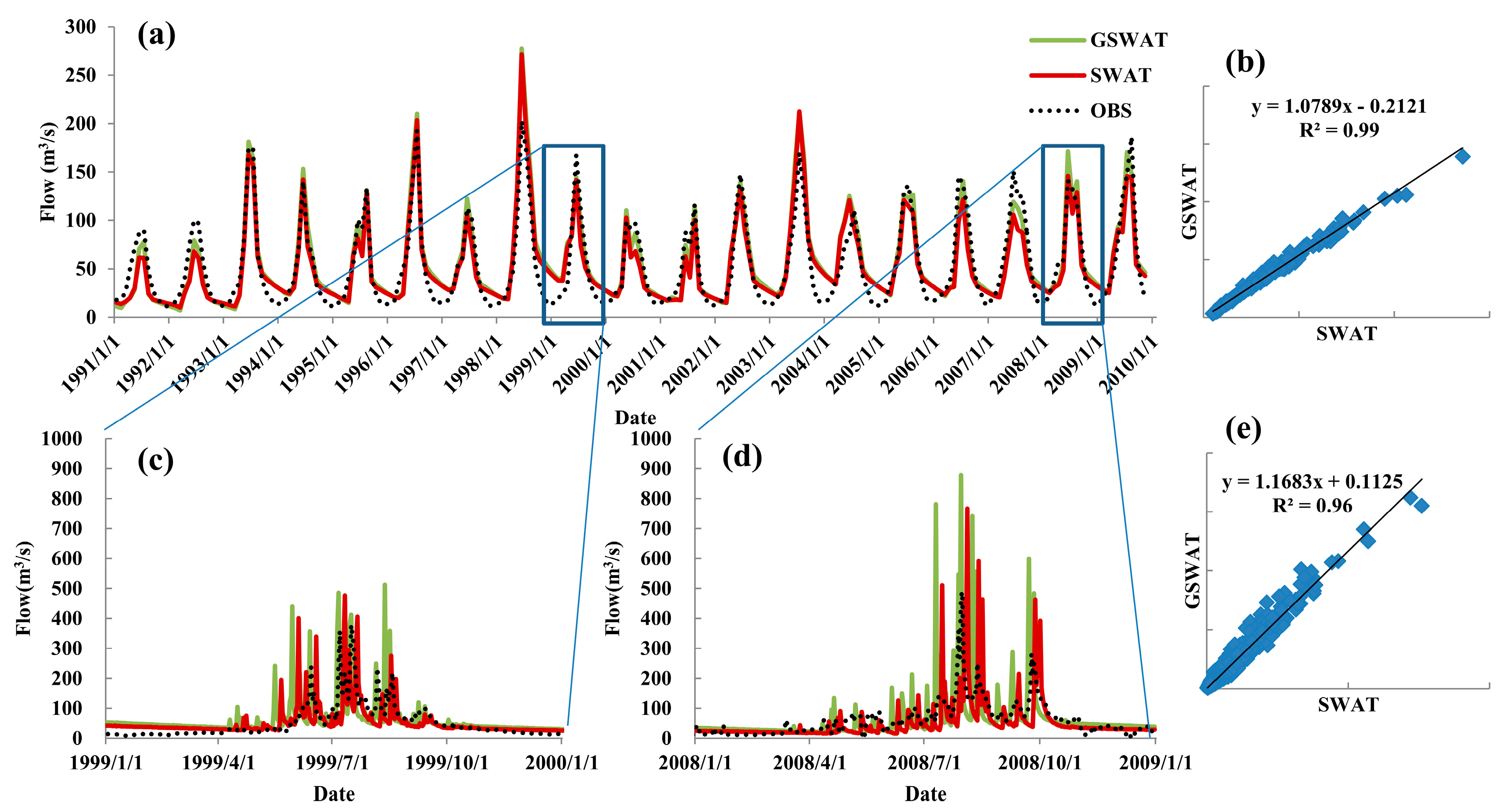
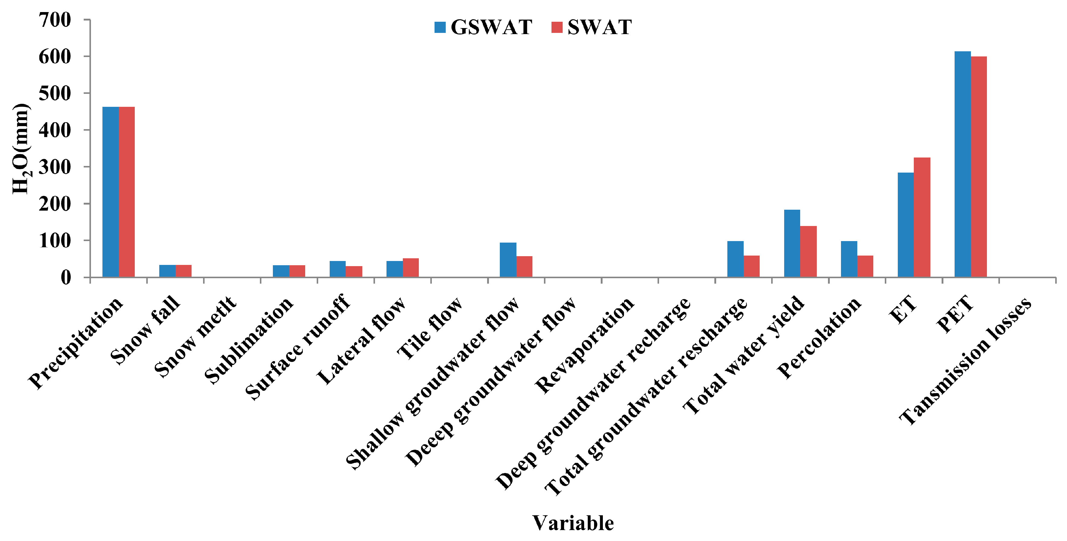
6.1. Hydrological Modeling Experiment
6.2. Evapotranspiration Data Assimilation Experiments
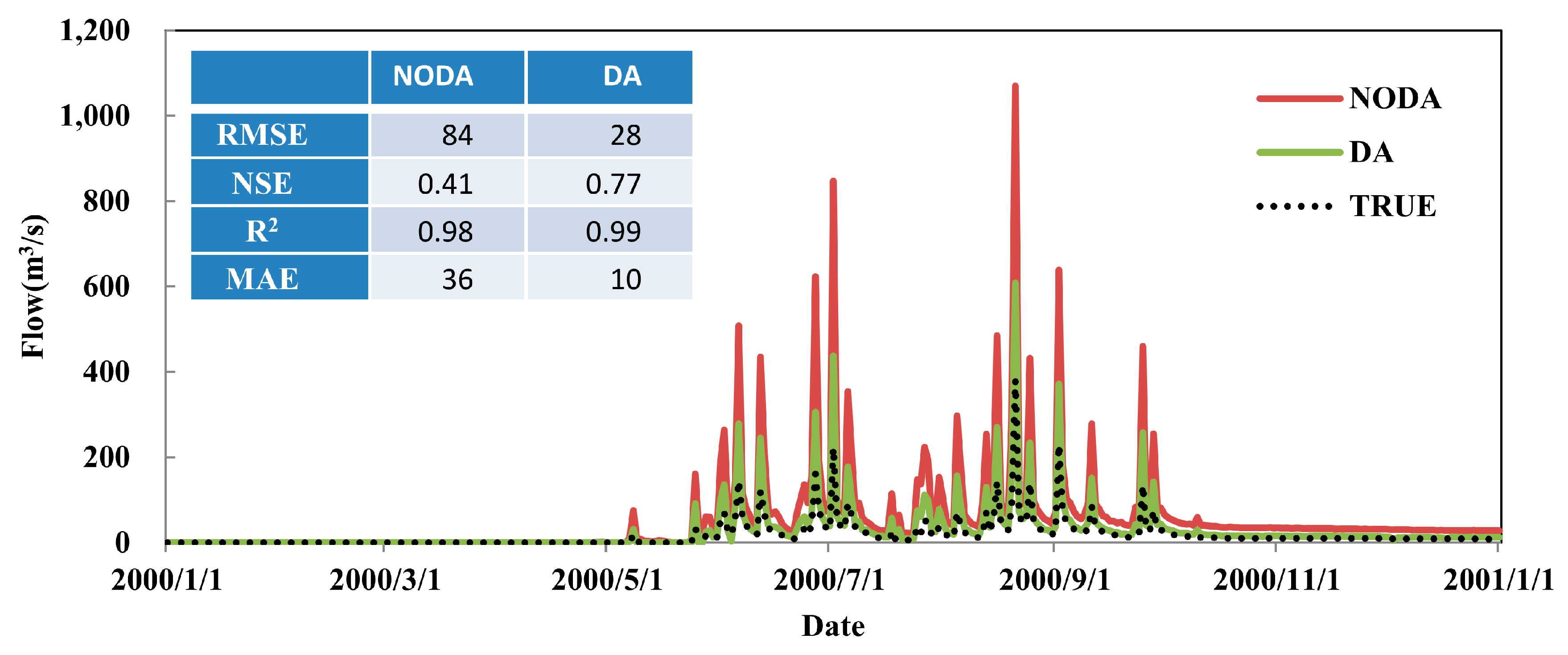
6.2.1. Synthetic Experiment
6.2.2. Real Data Experiment
- (1)
- Calibration integration: GSWATCALI performs better than GSWAT and GSWATCALIET performs better than GSWATET. For example, the RMSE for GSWATCALI is less than for the GSWAT (82 versus 97 m3/s). The calibrated SWAT parameters may not be suitable for GSWAT daily streamflow estimations. Daily scale streamflow estimation can be further improved by calibrating model parameters based on daily streamflow observation. With or without ET assimilated, calibration procedure can still further diminish parameter (system) errors in models.
- (2)
- ET assimilation integration: GSWATET shows clearly improved streamflow peak rates estimations compared with GSWAT; ET assimilation decreases RMSE from 97 m3/s to 78 m3/s. After being calibrated, GSWATCALIET also presents a better streamflow prediction than GSWATCALI; ET assimilation decreased RMSE from 63 m3/s to 57 m3/s. Model system bias has little effect on ET assimilation. With or without calibration procedure, ET assimilation can still further improve streamflow prediction for GSWAT.
7. Summary and Outlooks
Acknowledgments
Author Contributions
Conflicts of Interest
Abbreviations
| ET | Evapotranspiration |
| SWAT | Soil and Water assessment Tool |
| HRU | Hydrologic Response Unit |
| GSWAT | Gridded Soil and Water Assessment Toll |
| DI | Direct Insertion |
| MODIS | Moderate Resolution Imaging Spectroradiometer |
| VIC | Variable Infiltration Capacity |
| AMSR-E | Advanced Microwave Scanning Radiometer for Earth Observing System |
| SWE | Snow Water Equivalent |
| LAI | Leaf Area Index |
| TRMM | Tropical Rainfall Measuring Mission |
| PET | Potential Evapotranspiration |
| CN2 | Curve Number II |
| SWATCALI | Calibrated SWAT model |
| GSWATCALI | Calibrated Gridded SWAT model |
| GSWATCALIET | Calibrated Gridded SWAT model with evapotranspiration assimilated |
References
- Vorosmarty, C.J.; Green, P.; Salisbury, J.; Lammers, R.B. Global water resources: Vulnerability from climate change and population growth. Science 2000, 289, 284–288. [Google Scholar] [CrossRef] [PubMed]
- Moiwo, J.P.; Tao, F.L. Contributions of precipitation, irrigation and soil water to evapotranspiration in (semi)-arid regions. Int. J. Climatol. 2015, 35, 1079–1089. [Google Scholar] [CrossRef]
- Tu, M.; Wang, F.; Zhou, Y.; Wang, S. Gridded water resource distribution simulation for China based on third-order basin data from 2002. Sustainability 2016, 8, 1309. [Google Scholar] [CrossRef]
- Fernald, A.; Tidwell, V.; Rivera, J.; Rodríguez, S.; Guldan, S.; Steele, C.; Ochoa, C.; Hurd, B.; Ortiz, M.; Boykin, K. Modeling sustainability of water, environment, livelihood, and culture in traditional irrigation communities and their linked watersheds. Sustainability 2012, 4, 2998–3022. [Google Scholar] [CrossRef]
- Aubert, D.; Loumagne, C.; Oudin, L. Sequential assimilation of soil moisture and streamflow data in a conceptual rainfall-runoff model. J. Hydrol. 2003, 280, 145–161. [Google Scholar] [CrossRef]
- Lievens, H.; Tomer, S.K.; Al Bitar, A.; De Lannoy, G.J.M.; Drusch, M.; Dumedah, G.; Franssen, H.J.H.; Kerr, Y.H.; Martens, B.; Pan, M.; et al. Smos soil moisture assimilation for improved hydrologic simulation in the murray darling basin, australia. Remote Sens. Environ. 2015, 168, 146–162. [Google Scholar] [CrossRef]
- Montero, R.A.; Schwanenberg, D.; Krahe, P.; Lisniak, D.; Sensoy, A.; Sorman, A.A.; Akkol, B. Moving horizon estimation for assimilating h-saf remote sensing data into the hbv hydrological model. Adv. Water Resour. 2016, 92, 248–257. [Google Scholar] [CrossRef]
- Lu, H.S.; Crow, W.T.; Zhu, Y.H.; Ouyang, F.; Su, J.B. Improving streamflow prediction using remotely-sensed soil moisture and snow depth. Remote Sens. 2016, 8, 503. [Google Scholar] [CrossRef]
- Lopez, P.L.; Wanders, N.; Schellekens, J.; Renzullo, L.J.; Sutanudjaja, E.H.; Bierkens, M.F.P. Improved large-scale hydrological modelling through the assimilation of streamflow and downscaled satellite soil moisture observations. Hydrol. Earth Syst. Sci. 2016, 20, 3059–3076. [Google Scholar] [CrossRef]
- Immerzeel, W.W.; Droogers, P. Calibration of a distributed hydrological model based on satellite evapotranspiration. J. Hydrol. 2008, 349, 411–424. [Google Scholar] [CrossRef]
- Huang, C.; Li, Y.; Gu, J.; Lu, L.; Li, X. Improving estimation of evapotranspiration under water-limited conditions based on sebs and modis data in arid regions. Remote Sens. 2015, 7, 16795–16814. [Google Scholar] [CrossRef]
- Kunnath-Poovakka, A.; Ryu, D.; Renzullo, L.J.; George, B. The efficacy of calibrating hydrologic model using remotely sensed evapotranspiration and soil moisture for streamflow prediction. J. Hydrol. 2016, 535, 509–524. [Google Scholar] [CrossRef]
- Vervoort, R.W.; Miechels, S.F.; van Ogtrop, F.F.; Guillaume, J.H.A. Remotely sensed evapotranspiration to calibrate a lumped conceptual model: Pitfalls and opportunities. J. Hydrol. 2014, 519, 3223–3236. [Google Scholar] [CrossRef]
- Pan, M.; Wood, E.F.; Wojcik, R.; McCabe, M.F. Estimation of regional terrestrial water cycle using multi-sensor remote sensing observations and data assimilation. Remote Sens. Environ. 2008, 112, 1282–1294. [Google Scholar] [CrossRef]
- Yin, J.; Zhan, C.; Ye, W. An experimental study on evapotranspiration data assimilation based on the hydrological model. Water Resour. Manag. 2016, 30, 5263–5279. [Google Scholar] [CrossRef]
- Irmak, A.; Kamble, B. Evapotranspiration data assimilation with genetic algorithms and swap model for on-demand irrigation. Irrig. Sci. 2009, 28, 101–112. [Google Scholar] [CrossRef]
- Rientjes, T.H.M.; Muthuwatta, L.P.; Bos, M.G.; Booij, M.J.; Bhatti, H.A. Multi-variable calibration of a semi-distributed hydrological model using streamflow data and satellite-based evapotranspiration. J. Hydrol. 2013, 505, 276–290. [Google Scholar] [CrossRef]
- Parr, D.; Wang, G.L.; Bjerklie, D. Integrating remote sensing data on evapotranspiration and leaf area index with hydrological modeling: Impacts on model performance and future predictions. J. Hydrometeorol. 2015, 16, 2086–2100. [Google Scholar] [CrossRef]
- Wang, Q.J.; Pagano, T.C.; Zhou, S.L.; Hapuarachchi, H.A.P.; Zhang, L.; Robertson, D.E. Monthly versus daily water balance models in simulating monthly runoff. J. Hydrol. 2011, 404, 166–175. [Google Scholar] [CrossRef]
- Robles-Morua, A.; Vivoni, E.R.; Mayer, A.S. Distributed hydrologic modeling in northwest mexico reveals the links between runoff mechanisms and evapotranspiration. J. Hydrometeorol. 2012, 13, 785–807. [Google Scholar] [CrossRef]
- Rawlins, M.A.; Frolking, S.; Lammers, R.B.; Vorosmarty, C.J. Effects of uncertainty in climate inputs on simulated evapotranspiration and runoff in the western arctic. Earth Interact. 2006, 10. [Google Scholar] [CrossRef]
- Vrugt, J.A.; ter Braak, C.J.F.; Clark, M.P.; Hyman, J.M.; Robinson, B.A. Treatment of input uncertainty in hydrologic modeling: Doing hydrology backward with markov chain monte carlo simulation. Water Resour. Res. 2008, 44. [Google Scholar] [CrossRef]
- Tian, Y.D.; Huffman, G.J.; Adler, R.F.; Tang, L.; Sapiano, M.; Maggioni, V.; Wu, H. Modeling errors in daily precipitation measurements: Additive or multiplicative? Geophys. Res. Lett. 2013, 40, 2060–2065. [Google Scholar] [CrossRef]
- Shao, Q.X.; Lerat, J.; Brink, H.; Tomkins, K.; Yang, A.; Peeters, L.; Li, M.; Zhang, L.; Podger, G.; Renzullo, L.J. Gauge based precipitation estimation and associated model and product uncertainties. J. Hydrol. 2012, 444, 100–112. [Google Scholar] [CrossRef]
- Arnold, J.G.; Srinivasan, R.; Muttiah, R.S.; Williams, J.R. Large area hydrologic modeling and assessment—Part 1: Model development. J. Am. Water Resour. Assoc. 1998, 34, 73–89. [Google Scholar] [CrossRef]
- Lee, G.; Shin, Y.; Jung, Y. Development of web-based recess model for estimating baseflow using swat. Sustainability 2014, 6, 2357–2378. [Google Scholar] [CrossRef]
- Douglas-Mankin, K.R.; Srinivasan, R.; Arnold, J.G. Soil and water assessment tool (swat) model: Current developments and applications. ASABE 2010, 53, 1423–1431. [Google Scholar] [CrossRef]
- Zhang, Y.; Hou, J.L.; Cao, Y.P.; Huang, C.L. Development and evaluation of a hru-based gridded approach in swat model for watershed-scale hydrological modelling. Environ. Model. Softw. 2016. under review. [Google Scholar]
- Zhang, Y.; Hou, J.; Cao, Y.; Gu, J.; Huang, C. Openmp parallelization of a gridded swat (swatg). Comput. Geosci. 2017. [Google Scholar] [CrossRef]
- Dhungel, R.; Allen, R.G.; Trezza, R.; Robison, C.W. Evapotranspiration between satellite overpasses: Methodology and case study in agricultural dominant semi-arid areas. Meteorol. Appl. 2016, 23, 714–730. [Google Scholar] [CrossRef]
- Neitsch, S.L.; Williams, J.R.; Arnold, J.; Kiniry, J. Soil and Water Assessment Tool Theoretical Documentation Version 2009; Texas Water Resources Institute: College Station, TX, USA, 2011. [Google Scholar]
- Easton, Z.M.; Fuka, D.R.; Walter, M.T.; Cowan, D.M.; Schneiderman, E.M.; Steenhuis, T.S. Re-conceptualizing the soil and water assessment tool (swat) model to predict runoff from variable source areas. J. Hydrol. 2008, 348, 279–291. [Google Scholar] [CrossRef]
- Li, X.; Bai, Y. Assimilating remote sensing data into land surface models: Theory and methods. In Land Surface Observation, Modeling and Data Assimilation; World Scientific: Singapore, 2013; pp. 143–170. [Google Scholar]
- Solomon, S. Relationship between precipitation evaporation and runoff in tropical-equatorial regions. Water Resour. Res. 1967, 3, 163–172. [Google Scholar] [CrossRef]
- Cheng, G.; Xin, L.; Zhao, W.; Xu, Z.; Qi, F.; Xiao, S.; Xiao, H. Integrated study of the water-ecosystem-economy in the heihe river basin. Natl. Sci. Rev. 2014, 1, 413–428. [Google Scholar] [CrossRef]
- Zhang, L.; Nan, Z.T.; Yu, W.J.; Ge, Y.C. Modeling land-use and land-cover change and hydrological responses under consistent climate change scenarios in the heihe river basin, china. Water Resour. Manag. 2015, 29, 4701–4717. [Google Scholar] [CrossRef]
- Hu, G.C.; Jia, L. Monitoring of evapotranspiration in a semi-arid inland river basin by combining microwave and optical remote sensing observations. Remote Sens. 2015, 7, 3056–3087. [Google Scholar] [CrossRef]
- Cui, Y.K.; Jia, L. A modified gash model for estimating rainfall interception loss of forest using remote sensing observations at regional scale. Water 2014, 6, 993–1012. [Google Scholar] [CrossRef]
- Kuzmin, P.P. On method for investigations of evaporation from the snow cover. Trans. State Hydrol. Inst. 1953, 41, 34–52. (In Russian) [Google Scholar]
- Penman, H.L. Natural evaporation from open water, bare soil and grass. Proc. R. Soc. Lond. 1948, 193, 120. [Google Scholar] [CrossRef]
- Dai, Y.; Shangguan, W.; Duan, Q.; Liu, B.; Fu, S.; Niu, G. Development of a china dataset of soil hydraulic parameters using pedotransfer functions for land surface modeling. J. Hydrometeorol. 2013, 14, 869–887. [Google Scholar] [CrossRef]
- Zambrano-Bigiarini, M.; Rojas, R. A model-independent particle swarm optimisation software for model calibration. Environ. Model. Softw. 2013, 43, 5–25. [Google Scholar] [CrossRef]
- Moradkhani, H.; Meskele, T.T. Probabilistic Assessment of the Satellite Rainfall Retrieval Error Translation to Hydrologic Response; Springer: Dordrecht, The Netherlands, 2010; pp. 229–242. [Google Scholar]
- Bloschl, G.; Sivapalan, M. Scale issues in hydrological modeling—A review. Hydrol. Process. 1995, 9, 251–290. [Google Scholar] [CrossRef]
- Arnold, J.G.; Allen, P.M.; Volk, M.; Williams, J.R.; Bosch, D.D. Assessment of different representations of spatial variability on swat model performance. ASABE 2010, 53, 1433–1443. [Google Scholar] [CrossRef]
- Rathjens, H.; Oppelt, N. Swatgrid: An interface for setting up swat in a grid-based discretization scheme. Comput. Geosci. 2012, 45, 161–167. [Google Scholar] [CrossRef]
- Tobin, K.J.; Bennett, M.E. Constraining swat calibration with remotely sensed evapotranspiration data. J. Am. Water Resour. Assoc. 2017, 53, 593–604. [Google Scholar] [CrossRef]
- Hartanto, I.M.; van der Kwast, J.; Alexandridis, T.K.; Almeida, W.; Song, Y.; van Andel, S.J.; Solomatine, D.P. Data assimilation of satellite-based actual evapotranspiration in a distributed hydrological model of a controlled water system. Int. J. Appl. Earth Obs. 2017, 57, 123–135. [Google Scholar] [CrossRef]
- Zou, L.; Zhan, C.; Xia, J.; Wang, T.; Gippel, C.J. Implementation of evapotranspiration data assimilation with catchment scale distributed hydrological model via an ensemble kalman filter. J. Hydrol. 2017, 549, 685–702. [Google Scholar] [CrossRef]
- Arnold, J.G.; Moriasi, D.N.; Gassman, P.W.; Abbaspour, K.C.; White, M.J.; Srinivasan, R.; Santhi, C.; Harmel, R.D.; van Griensven, A.; Van Liew, M.W.; et al. Swat: Model use, calibration, and validation. ASABE 2012, 55, 1491–1508. [Google Scholar] [CrossRef]
- Huang, C.L.; Hu, B.X.; Li, X.; Ye, M. Using data assimilation method to calibrate a heterogeneous conductivity field and improve solute transport prediction with an unknown contamination source. Stoch. Env Res. Risk A 2009, 23, 1155–1167. [Google Scholar] [CrossRef]
- Moon, J.; Srinivasan, R.; Jacobs, J.H. Stream flow estimation using spatially distributed rainfall in the trinity River Basin, Texas. Trans ASAE 2004, 47, 1445–1451. [Google Scholar] [CrossRef]
- Tobin, K.J.; Bennett, M.E. Using swat to model streamflow in two river basins with ground and satellite precipitation data. Jawra J. Am. Water Resour. Assoc. 2010, 45, 253–271. [Google Scholar] [CrossRef]
- Lopez, P.L.; Sutanudjaja, E.H.; Schellekens, J.; Sterk, G.; Bierkens, M.F.P. Calibration of a large-scale hydrological model using satellite-based soil moisture and evapotranspiration products. Hydrol. Earth Syst. Sci. 2017, 21, 3125–3144. [Google Scholar] [CrossRef]
- Hassan, S.M.T.; Lubczynski, M.W.; Niswonger, R.G.; Su, Z.B. Surface-groundwater interactions in hard rocks in Sardon catchment of western Spain: An integrated modeling approach. J. Hydrol. 2014, 517, 390–410. [Google Scholar] [CrossRef]
- Pan, X.D.; Li, X.; Yang, K.; He, J.; Zhang, Y.L.; Han, X.J. Comparison of downscaled precipitation data over a mountainous watershed: A case study in the heihe river basin. J. Hydrometeorol. 2014, 15, 1560–1574. [Google Scholar] [CrossRef]
- Pan, X.D.; Li, X.; Cheng, G.D.; Li, H.Y.; He, X.B. Development and evaluation of a river-basin-scale high spatio-temporal precipitation data set using the wrf model: A case study of the heihe river basin. Remote Sens. 2015, 7, 9230–9252. [Google Scholar] [CrossRef]
- Vrugt, J.A.; Diks, C.G.H.; Gupta, H.V.; Bouten, W.; Verstraten, J.M. Improved treatment of uncertainty in hydrologic modeling: Combining the strengths of global optimization and data assimilation. Water Resour. Res. 2005, 41. [Google Scholar] [CrossRef]
- Chu, N.; Huang, C.L.; Li, X.; Du, P.J. Simultaneous estimation of surface soil moisture and soil properties with a dual ensemble kalman smoother. Sci. China Earth Sci. 2015, 58, 2327–2339. [Google Scholar] [CrossRef]
- Dhungel, R.; Allen, R.G.; Trezza, R.; Robison, C.W. Comparison of latent heat flux using aerodynamic methods and using the penman-monteith method with satellite-based surface energy balance. Remote Sens. 2014, 6, 8844–8877. [Google Scholar] [CrossRef]


| Name | SWAT | GSWAT | |
|---|---|---|---|
| Data | Forcing input | Weather station data | Gridded data |
| Parameters | |||
| Basin level | basin.bsn | basin.bsn | |
| Subbasin level | *.sub, *.rte | *.sub, *.rte | |
| HRU level | *.hru, *.mgt, *.swq, *.gw | Grid files (hruid.txt, subid.txt) and database file (hru.txt) | |
| Output | output.* | Daily and yearly variables grid files (*.asc) | |
| Model | Unit | HRU | Grid cell |
| Domain | DEM-based watershed delineation | Grid scheme-based watershed delineation | |
| Water balance equation | Equation (1) | Equation (1) |
| Parameter Name | Description | Range | |
|---|---|---|---|
| Minimum | Maximum | ||
| ALPHA_BF | Base flow alpha factor (days) | 0.01 | 0.99 |
| CH_K2 | Effective hydraulic conductivity in main channel alluvium (mm/h) | 0 | 200 |
| CN2 | Initial SCS CN II value | 10 | 95 |
| SOL_AWC | Available water capacity (mm H2O/mm soil) | 0.01 | 0.035 |
| SOL_K | Saturated hydraulic conductivity (mm/h) | 0.001 | 1000 |
| ESCO | Soil evaporation compensation factor | 0.01 | 1 |
| CH_N2 | Manning’s “n” value for the main channel | 0.016 | 0.15 |
| SFTMP | Snowfall temperature (°C) | −5 | 5 |
| SURLAG | Surface runoff lag time (days) | 1 | 12 |
| SMTMP | Snowmelt base temperature (°C) | −5 | 5 |
| SMFMN | Minimum melt factor for snow (°C) | 1.4 | 6.9 |
| TIMP | Snowpack temperature lag factor | 0.01 | 0.6 |
| SMFMX | Maximum melt factor for snow (°C) | 1.4 | 4 |
| OV_N | Manning’s “n” value for overland flow | 0.008 | 0.6 |
| RCHRG_DP | Deep aquifer percolation factor | 0 | 1 |
| GWQMN | Threshold water depth in the shallow aquifer for flow (mm) | 0 | 5000 |
| GW_REVAP | Groundwater “revap” coefficient | 0 | 0.2 |
| GW_DELAY | Groundwater delay time (days) | 1 | 100 |
| SOL_ALB | Moist soil albedo | 0 | 0.1 |
| REVAVMN | Threshold water depth in the shallow aquifer for “revap” (mm) | 1 | 500 |
| EPCO | Plant uptake compensation factor | 0.01 | 1 |
| CANMX | Maximum canopy storage (mm H2O) | 0 | 10 |
| CASE | Model | Forcing | Measurement |
|---|---|---|---|
| TRUE | GSWAT | Weather station data (P) | |
| NODA | GSWAT | Pperturbed (Equation (11)) | |
| DA | GSWAT | Pperturbed | ET |
| CASE | Model | Method | ||
|---|---|---|---|---|
| SWAT | GSWAT | Calibration | ET assimilation | |
| SWAT | √ | √ | ||
| GSWAT | √ | |||
| GSWATET | √ | √ | ||
| GSWATCALI | √ | √ | ||
| GSWATCALIET | √ | √ | √ | |
| SWAT | GSWAT | GSWATCALI | GSWATET | GSWATCALIET | |
|---|---|---|---|---|---|
| RMSE (m3/s) | 78.8 | 97.4 | 63.4 | 78.5 | 56.8 |
| R2 | 0.49 | 0.45 | 0.57 | 0.49 | 0.60 |
| MAE (m3/s) | 34.5 | 37.8 | 31.9 | 33.9 | 30.8 |
| NSE | 0.17 | 0.19 | 0.23 | 0.17 | 0.17 |
© 2017 by the authors. Licensee MDPI, Basel, Switzerland. This article is an open access article distributed under the terms and conditions of the Creative Commons Attribution (CC BY) license (http://creativecommons.org/licenses/by/4.0/).
Share and Cite
Zhang, Y.; Zhang, L.; Hou, J.; Gu, J.; Huang, C. Development of an Evapotranspiration Data Assimilation Technique for Streamflow Estimates: A Case Study in a Semi-Arid Region. Sustainability 2017, 9, 1658. https://doi.org/10.3390/su9101658
Zhang Y, Zhang L, Hou J, Gu J, Huang C. Development of an Evapotranspiration Data Assimilation Technique for Streamflow Estimates: A Case Study in a Semi-Arid Region. Sustainability. 2017; 9(10):1658. https://doi.org/10.3390/su9101658
Chicago/Turabian StyleZhang, Ying, Ling Zhang, Jinliang Hou, Juan Gu, and Chunlin Huang. 2017. "Development of an Evapotranspiration Data Assimilation Technique for Streamflow Estimates: A Case Study in a Semi-Arid Region" Sustainability 9, no. 10: 1658. https://doi.org/10.3390/su9101658
APA StyleZhang, Y., Zhang, L., Hou, J., Gu, J., & Huang, C. (2017). Development of an Evapotranspiration Data Assimilation Technique for Streamflow Estimates: A Case Study in a Semi-Arid Region. Sustainability, 9(10), 1658. https://doi.org/10.3390/su9101658