
Coupling an Intercalibration of Radiance-Calibrated Nighttime Light Images and Land Use/Cover Data for Modeling and Analyzing the Distribution of GDP in Guangdong, China

Abstract
:1. Introduction
2. Study Area, Data, and Pre-Processing
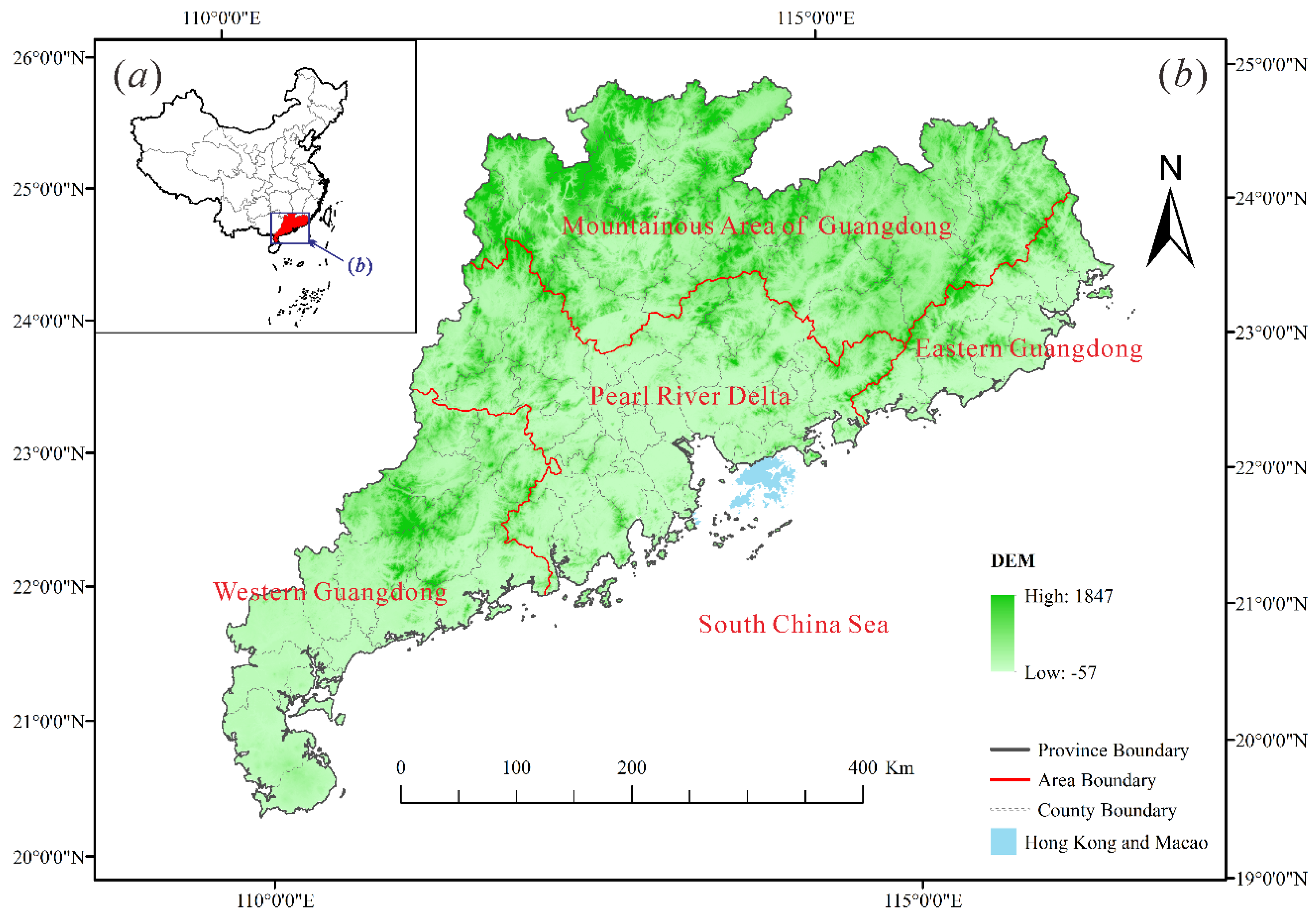
2.1. Study Area

2.2. Data and Pre-Processing
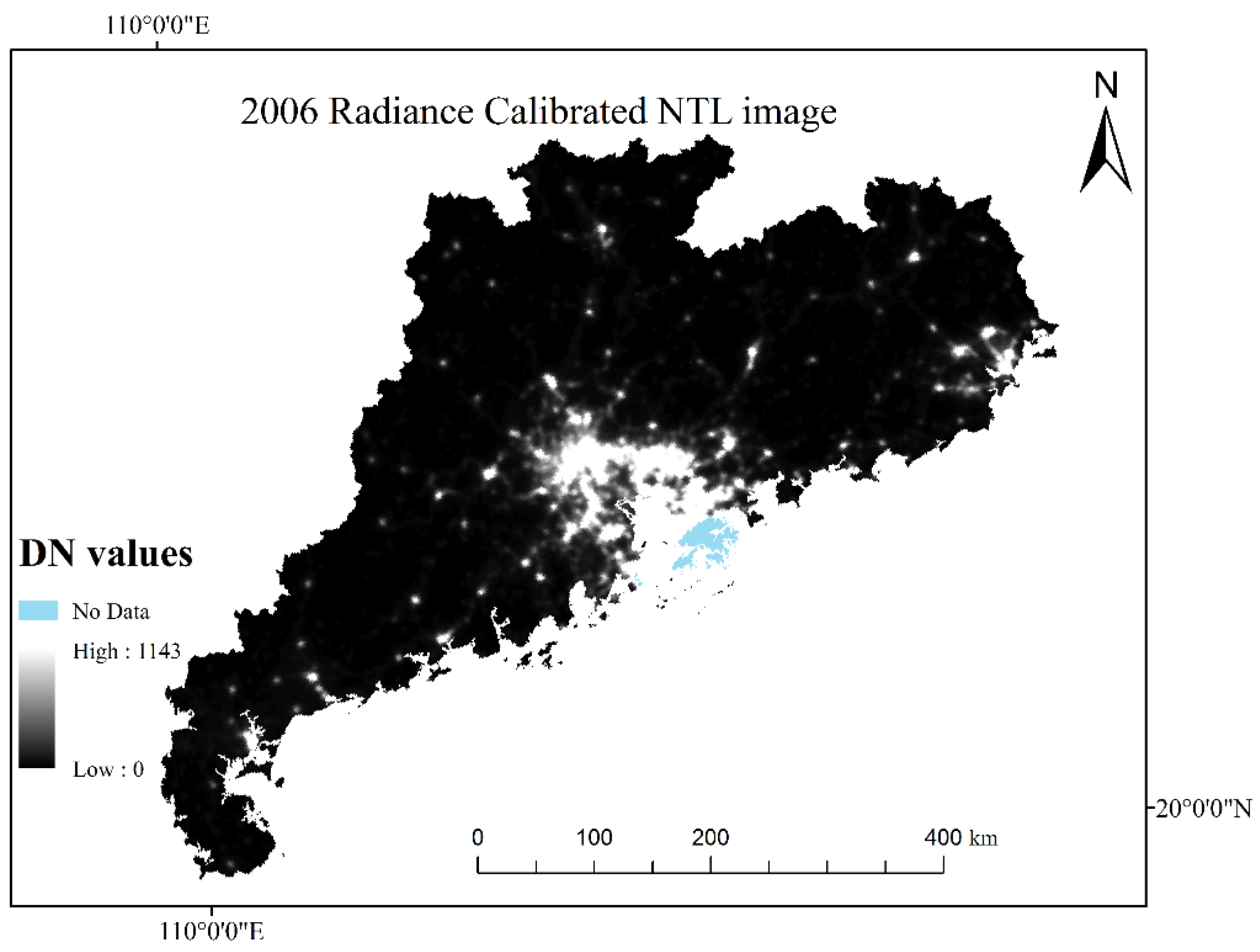
2.2.1. Defense Meteorological Satellite Program/Operational Linescan System (DMSP/OLS) Nighttime Light Image
2.2.2. Moderate-Resolution Imaging Spectroradiometer Normalized Difference Vegetation Index Data
2.2.3. Land Use/Cover Data
2.2.4. Ancillary Data
3. Methods
3.1. Intercalibration of DMSP/OLS Radiance-Calibrated Nighttime Light Time Series Images
3.1.1. Inter-Satellite Calibration
3.1.2. Inter-Annual Calibration

| Satellite_Year | R2 (Linear) | R2 (Second Order Polynomial) | ||
|---|---|---|---|---|
| Shenzhen | Guangzhou | Shenzhen | Guangzhou | |
| F12-F15_20000103-20001229 | 0.9059 | 0.9083 | 0.9403 | 0.9176 |
| F14_20040118-20041216 | 0.9176 | 0.9595 | 0.9597 | 0.9628 |
| F16_20051128-20061224 | 1.0000 | 1.0000 | 1.0000 | 1.0000 |
| F16_20100111-20101209 | 0.6843 | 0.7918 | 0.6845 | 0.8317 |
| F16_20100111-20110731 | 0.9037 | 0.9383 | 0.9398 | 0.9497 |
3.1.3. Inter-Annual Series Correction
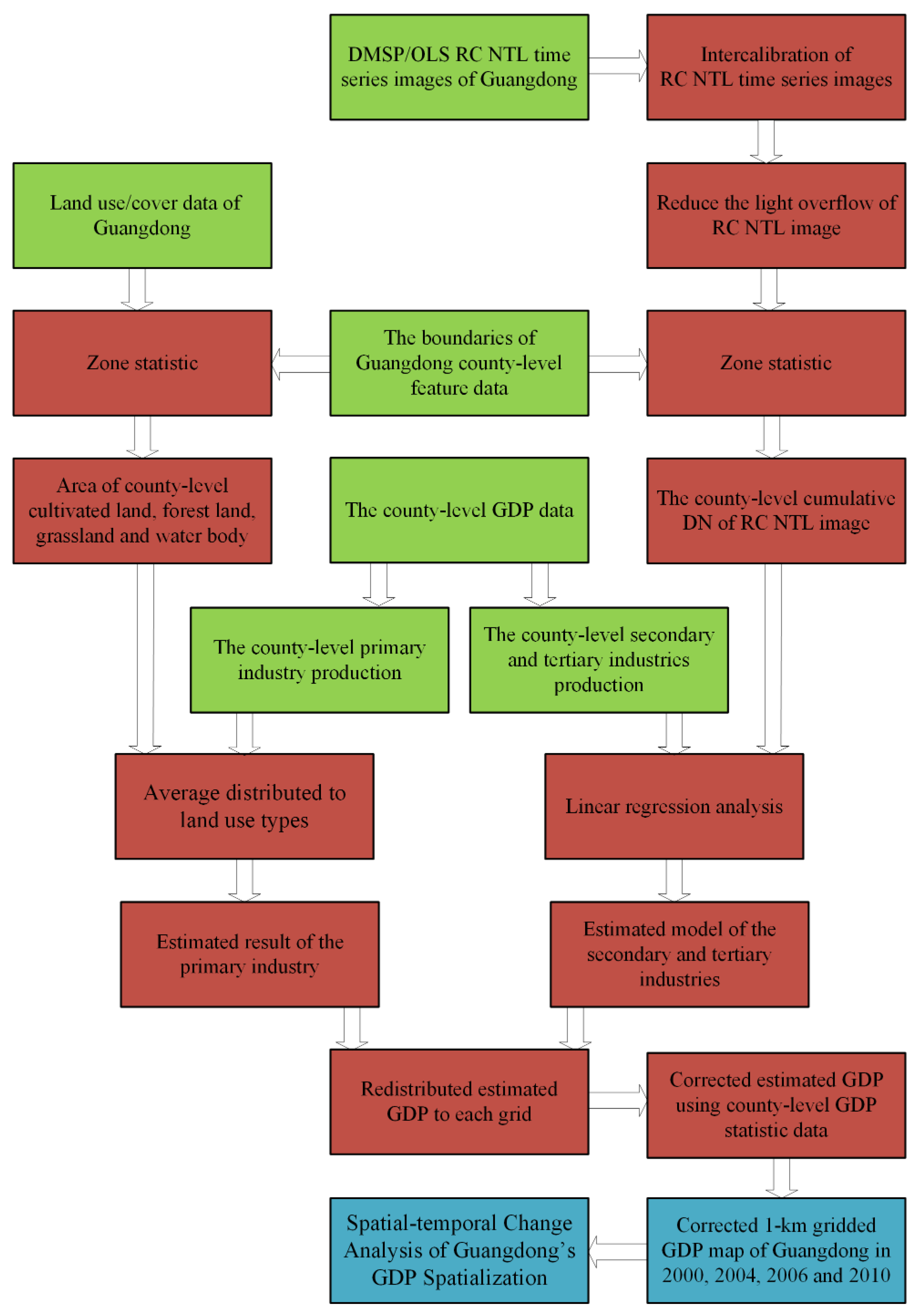
3.2. Estimation of GDP Spatialization by Land Use/Cover Data and RC NTL Imagery
3.2.1. Estimation of the Primary Industry Production by Using Land Use/Cover Data
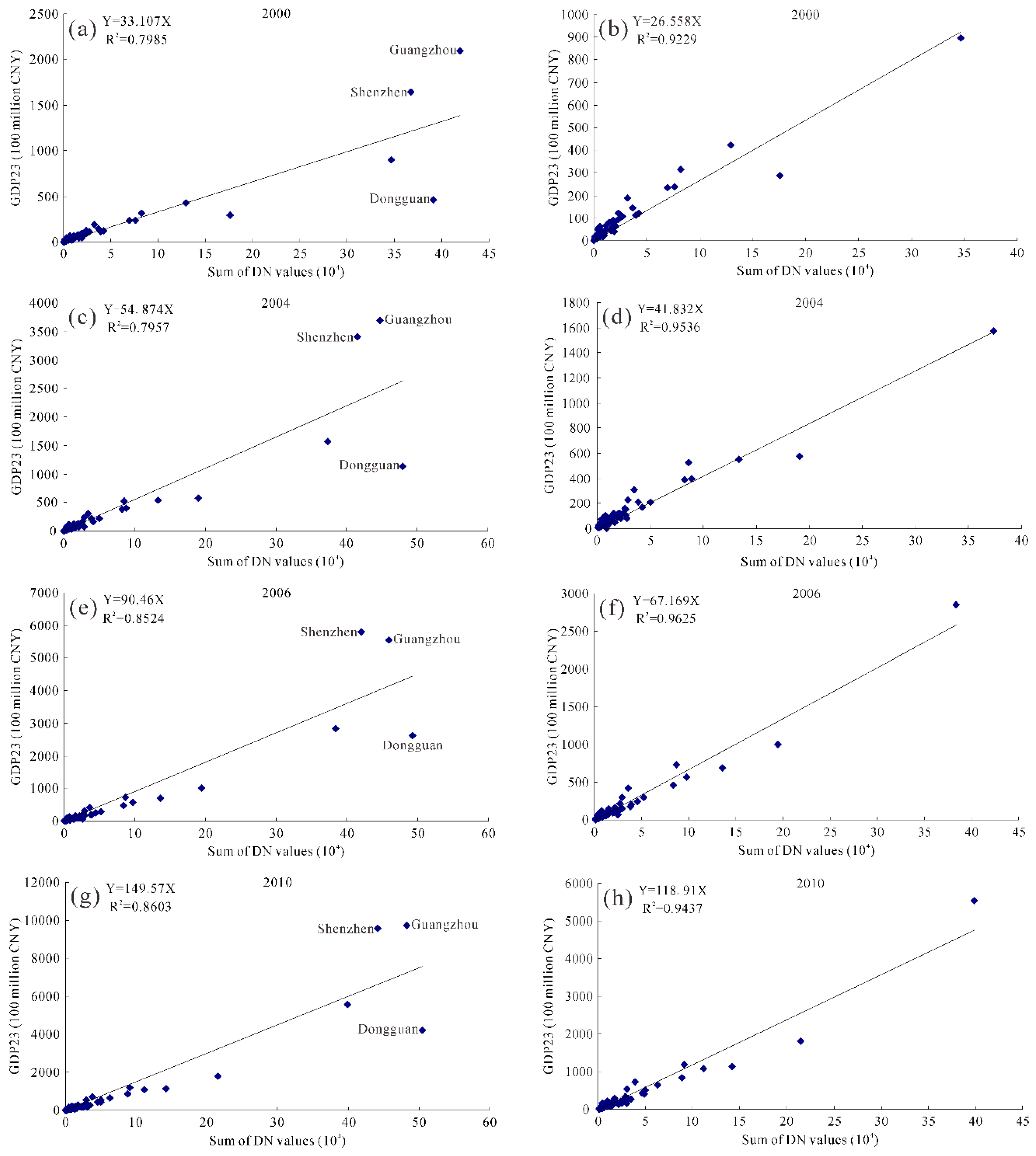
3.2.2. Estimation of the Secondary and Tertiary Industries Production by Using RC NTL Imagery
| RC NTL Images after Intercalibration | NDVI Value | Threshold |
|---|---|---|
| Satellite_Year | X | Y |
| F12-F15_20000103-20001229 | 0.516 | 21.57 |
| F14_20040118-20041216 | 0.5543 | 18.2 |
| F16_20051128-20061224 | 0.5326 | 17.71 |
| F16_20100111-20101209 | 0.5544 | 15.5 |

4. Results and Discussion
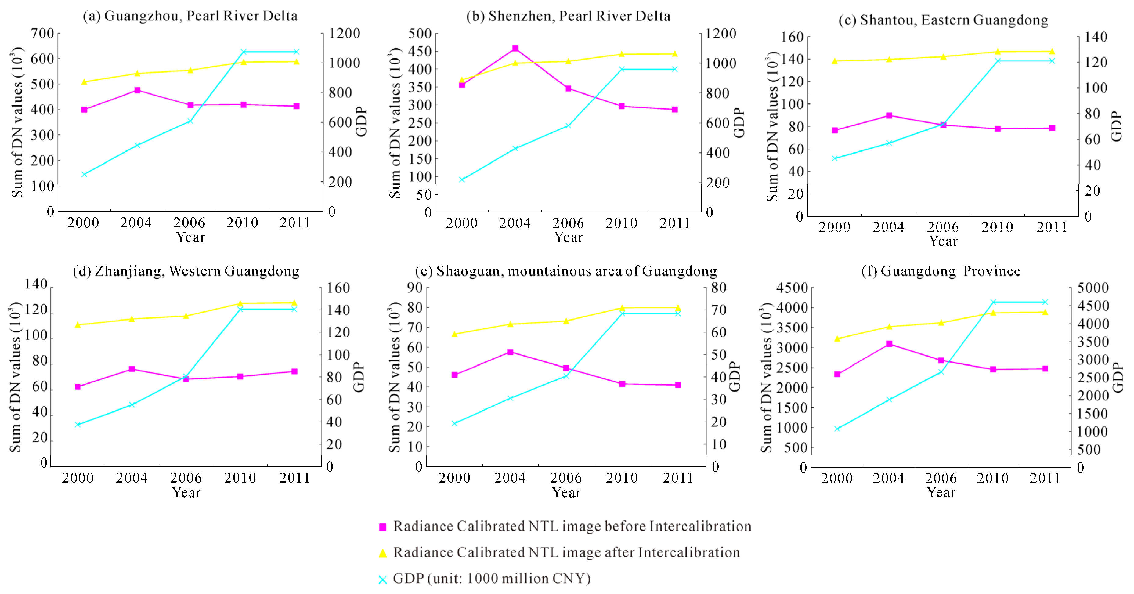
4.1. Verifying the Intercalibration Results of Radiance-Calibrated Time Series Images

| City | Year | RC NTL Images | IC-RC NTL Images | ||
|---|---|---|---|---|---|
| Urban Core | Whole Urban | Urban Core | Whole Urban | ||
| Guangzhou | 2000 | 117,364 | 399,590 | 103,177 | 508,855 |
| 2004 | 112,311 | 474,931 | 108,411 | 541,923 | |
| 2006 | 91,204 | 417,618 | 110,632 | 553,827 | |
| 2010 | 97,775 | 419,465 | 111,817 | 586,157 | |
| 2010_2011 | 100,170 | 413,052 | 111,824 | 588,204 | |
| Shenzhen | 2000 | 152,806 | 355,733 | 126,256 | 369,792 |
| 2004 | 183,370 | 457,437 | 149,434 | 416,756 | |
| 2006 | 115,359 | 345,483 | 149,452 | 421,767 | |
| 2010 | 87,445 | 296,498 | 150,087 | 441,978 | |
| 2010_2011 | 84,579 | 287,314 | 150,087 | 442,839 | |
| Year | RC NTL Image | IC-RC NTL Image * | T-IC-RC NTL Image * |
|---|---|---|---|
| 2000 | 0.8373 | 0.8002 | 0.7988 |
| 2004 | 0.7754 | 0.7949 | 0.7957 |
| 2006 | 0.8383 | 0.8518 | 0.8541 |
| 2010 | 0.8862 | 0.8612 | 0.8623 |
4.2. Accuracy Assessment Results for the Estimated GDP in Guangdong Province
| NTL Image | Level | 2000 | 2004 | 2006 | 2010 | ||||
|---|---|---|---|---|---|---|---|---|---|
| County | City | County | City | County | City | County | City | ||
| RC NTL image | 1 | 38 | 14 | 40 | 14 | 12 | 7 | 14 | 5 |
| 2 | 28 | 5 | 21 | 4 | 20 | 4 | 12 | 4 | |
| 3 | 6 | 0 | 6 | 1 | 17 | 6 | 21 | 10 | |
| 4 | 10 | 2 | 15 | 2 | 33 | 4 | 35 | 2 | |
| T-IC-RC NTL image * | 1 | 29 | 13 | 21 | 8 | 10 | 5 | 13 | 5 |
| 2 | 20 | 2 | 19 | 7 | 8 | 0 | 9 | 0 | |
| 3 | 11 | 2 | 13 | 4 | 12 | 6 | 12 | 8 | |
| 4 | 22 | 4 | 29 | 2 | 52 | 10 | 48 | 8 | |
| RO-T-IC-RC NTL image * | 1 | 32 | 10 | 44 | 13 | 52 | 19 | 47 | 14 |
| 2 | 42 | 10 | 34 | 7 | 29 | 2 | 29 | 7 | |
| 3 | 7 | 0 | 4 | 1 | 0 | 0 | 4 | 0 | |
| 4 | 1 | 1 | 0 | 0 | 1 | 0 | 2 | 0 | |
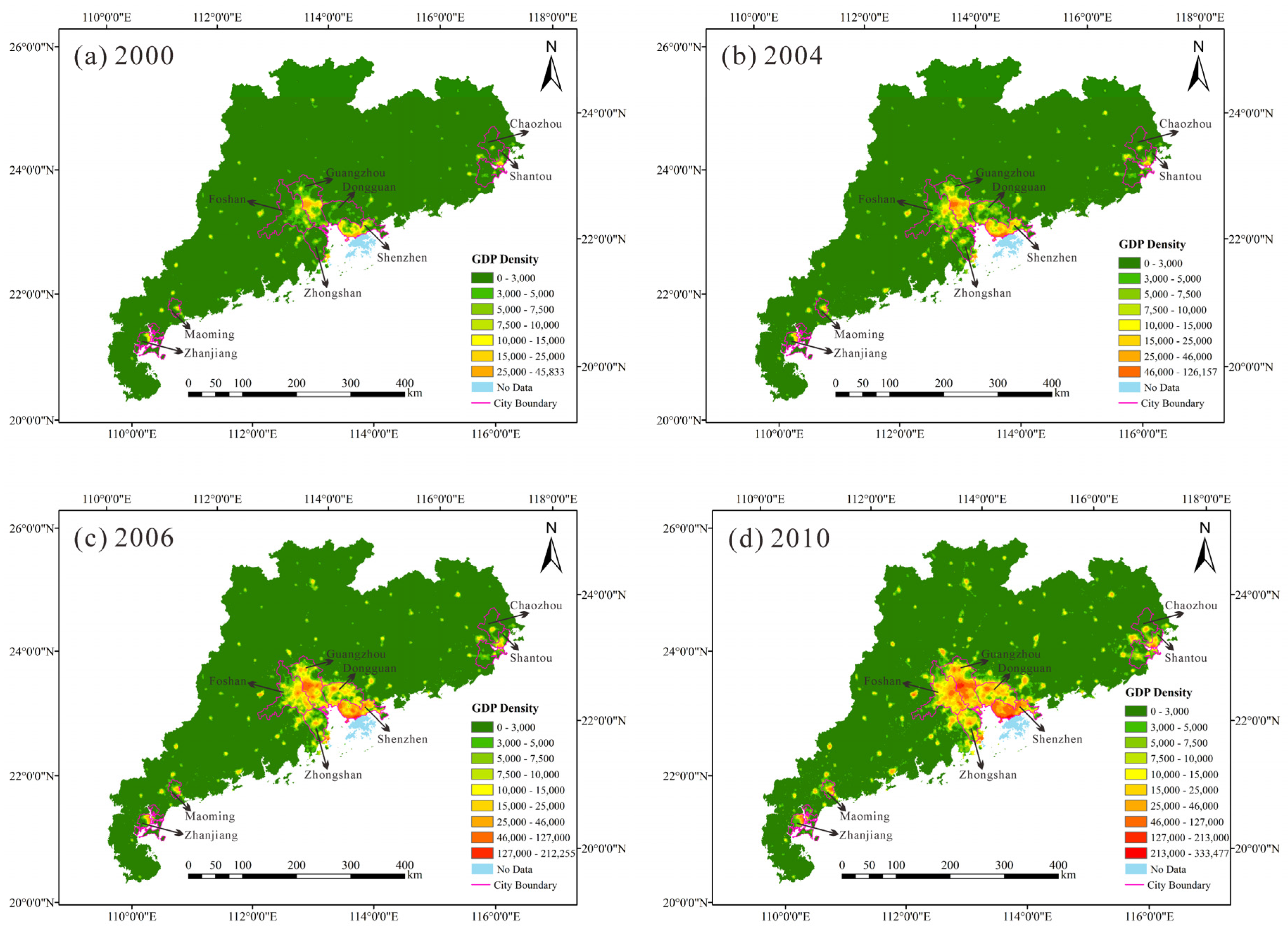
4.3. Comparison and Analysis of GDP Density of Guangdong Province in 2000, 2004, 2006 and 2010

5. Conclusions
Acknowledgments
Author Contributions
Conflicts of Interest
References
- Stevenson, R.J.; Sabater, S. Understanding effects of global change on river ecosystems: Science to support policy in a changing world. Hydrobiologia 2010, 657, 3–18. [Google Scholar] [CrossRef]
- Sang, X.F.; Zhou, Z.H.; Wang, H.; Qin, D.Y.; Zhai, Z.L.; Chen, Q. Development of soil and water assessment tool model on human water use and application in the area of high human activities, Tianjin, China. J. Irrig. Drain. Eng. 2010, 136, 23–30. [Google Scholar] [CrossRef]
- Huo, Z.L.; Feng, S.Y.; Kang, S.Z.; Dai, X.Q.; Li, W.C.; Chen, S.J. The response of water-land environment to human activities in arid minqin oasis, northwest china. Arid Land Res. Manag. 2007, 21, 21–36. [Google Scholar] [CrossRef]
- Wang, J.N.; Lu, Y.T.; Zhou, J.S.; Li, Y.; Cao, D. Analysis of China resource-environment Gini coefficient based on GDP. China Environ. Sci. 2006, 26, 111–115. [Google Scholar]
- Chen, K.P.; McAneney, J.; Blong, R.; Leigh, R.; Hunter, L.; Magill, C. Defining area at risk and its effect in catastrophe loss estimation: A dasymetric mapping approach. Appl. Geogr. 2004, 24, 97–117. [Google Scholar] [CrossRef]
- Thieken, A.H.; Muller, M.; Kleist, L.; Seifert, I.; Borst, D.; Werner, U. Regionalisation of asset values for risk analyses. Nat. Hazards Earth Syst. Sci. 2006, 6, 167–178. [Google Scholar] [CrossRef]
- Liu, H.H.; Jiang, D.; Yang, X.H.; Luo, C. Spatialization Approach to 1 km Grid GDP Supported by Remote Sensing. Geoinf. Sci. 2005, 7, 120–123. [Google Scholar]
- Han, X.D.; Zhou, Y.; Wang, S.X.; Liu, R.; Yao, Y. GDP spatializarion in China based on nighttime imagery. J. Geoinf. Sci. 2012, 14, 128–136. [Google Scholar]
- Elvidge, C.; Baugh, K.; Hobson, V.; Kihn, E.; Kroehl, H.; Davis, E.; Cocero, D. Satellite inventory of human settlements using nocturnal radiation emissions: A contribution for the global toolchest. Glob. Chang. Biol. 1997, 3, 387–395. [Google Scholar] [CrossRef]
- Elvidge, C.D.; Baugh, K.E.; Dietz, J.B.; Bland, T.; Sutton, P.C.; Kroehl, H.W. Radiance calibration of DMSP-OLS low-light imaging data of human settlements. Remote Sens. Environ. 1999, 68, 77–88. [Google Scholar] [CrossRef]
- Elvidge, C.D.; Imhoff, M.L.; Baugh, K.E.; Hobson, V.R.; Nelson, I.; Safran, J.; Dietz, J.B.; Tuttle, B.T. Night-time lights of the world: 1994–1995. ISPRS J. Photogramm. Remote Sens. 2001, 56, 81–99. [Google Scholar] [CrossRef]
- Doll, C.N.H.; Muller, J.-P.; Morley, J.G. Mapping regional economic activity from night-time light satellite imagery. Ecol. Econ. 2006, 57, 75–92. [Google Scholar] [CrossRef]
- Elvidge, C.D.; Sutton, P.C.; Ghosh, T.; Tuttle, B.T.; Baugh, K.E.; Bhaduri, B.; Bright, E. A global poverty map derived from satellite data. Comput. Geosci. 2009, 35, 1652–1660. [Google Scholar] [CrossRef]
- Elvidge, C.D.; Baugh, K.E.; Kihn, E.A.; Kroehl, H.W.; Davis, E.R.; Davis, C.W. Relation between satellite observed visible-near infrared emissions, population, economic activity and electric power consumption. Int. J. Remote Sens. 1997, 18, 1373–1379. [Google Scholar] [CrossRef]
- Doll, C.H.; Muller, J.-P.; Elvidge, C.D. Night-time imagery as a tool for global mapping of socioeconomic parameters and greenhouse gas emissions. Ambio 2000, 29, 157–162. [Google Scholar] [CrossRef]
- Wang, Q.; Yuan, T.; Zheng, X.Q. GDP gross analysis at province-level in China based on night-time lightsatellite imagery. Urban Dev. Stud. 2013, 20, 44–48. [Google Scholar]
- Cao, X.; Wang, J.; Chen, J.; Shi, F. Spatialization of electricity consumption of china using saturation-corrected DMSP-OLS data. Int. J. Appl. Earth Obs. Geoinf. 2014, 28, 193–200. [Google Scholar] [CrossRef]
- Wang, W.; Cheng, H.; Zhang, L. Poverty assessment using DMSP/OLS night-time light satellite imagery at a provincial scale in China. Adv. Space Res. 2012, 49, 1253–1264. [Google Scholar] [CrossRef]
- Takahashi, K.I.; Terakado, R.; Nakamura, J.; Adachi, Y.; Elvidge, C.D.; Matsuno, Y. In-use stock analysis using satellite nighttime light observation data. Resour. Conserv. Recycl. 2010, 55, 196–200. [Google Scholar] [CrossRef]
- Liang, H.W.; Tanikawa, H.; Matsuno, Y.; Dong, L. Modeling in-use steel stock in china’s buildings and civil engineering infrastructure using time-series of DMSP/OLS nighttime lights. Remote Sens. 2014, 6, 4780–4800. [Google Scholar] [CrossRef]
- Zhang, L.; Qu, G.; Wang, W. Estimating land development time lags in China using DMSP/OLS nighttime light image. Remote Sens. 2015, 7, 882–904. [Google Scholar] [CrossRef]
- Sutton, P.C.; Costanza, R. Global estimates of market and non-market values derived from nighttime satellite imagery, land cover, and ecosystem service valuation. Ecol. Econ. 2002, 41, 509–527. [Google Scholar] [CrossRef]
- Ghosh, T.; Powell, R.L.; Elvidge, C.D.; Baugh, K.E.; Sutton, P.C.; Anderson, S. Shedding light on the global distribution of economic activity. Open Geogr. J. 2010, 3, 148–161. [Google Scholar]
- Han, X.D.; Zhou, Y.; Wang, S.X.; Liu, R.; Yao, Y. GDP spatialization in China based on DMSP/OLS data and land use data. Remote Sens. Technol. Appl. 2012, 27, 396–405. [Google Scholar]
- Yang, Y.; Wu, L.L.; Deng, S.L.; Zhang, C. Spatialization method of provincial statistical GDP data based on DMSP/OLS night lighting data: A case study of Guangxi Zhuang Autonomous Region. Geogr. Geoinf. Sci. 2014, 30, 108–111. [Google Scholar]
- Elvidge, C.D.; Cinzano, P.; Pettit, D.R.; Arvesen, J.; Sutton, P.; Small, C.; Nemani, R.; Longcore, T.; Rich, C.; Safran, J.; et al. The nightsat mission concept. Int. J. Remote Sens. 2007, 28, 2645–2670. [Google Scholar] [CrossRef]
- Imhoff, M.L.; Lawrence, W.T.; Stutzer, D.C.; Elvidge, C.D. A technique for using composite DMSP/OLS “city lights” satellite data to map urban area. Remote Sens. Environ. 1997, 61, 361–370. [Google Scholar] [CrossRef]
- Letu, H.; Bao, Y.H.; Tana, G.; Hara, M.; Nishio, F. Relationship between DMSP/OLS nighttime light and CO2 emission from electric power plant. Land Surf. Remote Sens. 2012. [Google Scholar] [CrossRef]
- Zhang, Q.; Schaaf, C.; Seto, K.C. The vegetation adjusted ntl urban index: A new approach to reduce saturation and increase variation in nighttime luminosity. Remote Sens. Environ. 2013, 129, 32–41. [Google Scholar] [CrossRef]
- Small, C.; Elvidge, C.D.; Balk, D.; Montgomery, M. Spatial scaling of stable night lights. Remote Sens. Environ. 2011, 115, 269–280. [Google Scholar] [CrossRef]
- Yue, W.Z.; Gao, J.B.; Yang, X.C. Estimation of gross domestic product using multi-sensor remote sensing data: A case study in Zhejiang province, East China. Remote Sens. 2014, 6, 7260–7275. [Google Scholar] [CrossRef]
- Ziskin, D.; Baugh, K.; Hsu, F.-C.; Elvidge, C.D. Methods used for the 2006 radiance lights. Proc. Asia Pac. Adv. Netw. 2010, 30, 131–142. [Google Scholar] [CrossRef]
- Hsu, F.-C.; Baugh, K.E.; Ghosh, T.; Zhizhin, M.; Elvidge, C.D. Dmsp-ols radiance calibrated nighttime lights time series with intercalibration. Remote Sens. 2015, 7, 1855–1876. [Google Scholar] [CrossRef]
- Lu, D.; Tian, H.; Zhou, G.; Ge, H. Regional mapping of human settlements in Southeastern China with multisensor remotely sensed data. Remote Sens. Environ. 2008, 112, 3668–3679. [Google Scholar] [CrossRef]
- Zhuo, L.; Zheng, J.; Zhang, X.; Li, J.; Liu, L. An improved method of night-time light saturation reduction based on EVI. Int. J. Remote Sens. 2015, 36, 4114–4130. [Google Scholar] [CrossRef]
- National Bureau of Statistics of China. China Statistical Yearbook 2010; China Statistics Press: Beijing, China, 2010. Available online: http://www.stats.gov.cn/tjsj/ndsj/ (accessed on 15 October 2015). (In Chinese)
- National Oceanic and Atmospheric Administration (NOAA)/National Geography Data Center (NGDC) Website. Available online: http://ngdc.noaa.gov/eog/download.html (accessed on 24 September 2015).
- National Aeronautics and Space Administration (NASA)/Goddard Space Flight Center (GSFC) Website. Available online: http://ladsweb.nascom.nasa.gov/data/search.html (accessed 7 October 2015).
- Fensholt, R.; Rasmussen, K.; Nielsen, T.T.; Mbow, C. Evaluation of earth observation based long term vegetation trends–intercomparing ndvi time series trend analysis consistency of sahel from avhrr gimms, terra modis and spot vgt data. Remote Sens. Environ. 2009, 113, 1886–1898. [Google Scholar] [CrossRef]
- Tarnavsky, E.; Garrigues, S.; Brown, M.E. Multiscale geostatistical analysis of avhrr, spot-vgt, and modis global ndvi products. Remote Sens. Environ. 2008, 112, 535–549. [Google Scholar] [CrossRef]
- Huete, A.; Didan, K.; Miura, T.; Rodriguez, E.P.; Gao, X.; Ferreira, L.G. Overview of the radiometric and biophysical performance of the modis vegetation indices. Remote Sens. Environ. 2002, 83, 195–213. [Google Scholar] [CrossRef]
- Resources and Environment Data Center of the Chinese Academy of Science Website. Available online: http://www.resdc.cn (accessed on 10 October 2015).
- Liu, J.; Liu, M.; Zhuang, D.; Zhang, Z.; Deng, X. Study on spatial pattern of land-use change in China during 1995–2000. Sci. China Ser. D Earth Sci. 2003, 46, 373–384. [Google Scholar]
- Ebener, S.; Murray, C.; Tandon, A.; Elvidge, C. From wealth to health: Modelling the distribution of income per capita at the sub-national level using night-time light imagery. Int. J. Health Geogr. 2005. [Google Scholar] [CrossRef] [PubMed]
- Liu, J.Y.; Zhang, Z.X.; Xu, X.L.; Kuang, W.H.; Zhou, W.C.; Zhang, S.W.; Li, R.D.; Yan, C.Z.; Yu, D.S.; Wu, S.X.; et al. Spatial patterns and driving forces of land use change in China during the early 21st century. J. Geogr. Sci. 2010, 20, 483–494. [Google Scholar] [CrossRef]
- Statistics Bureau of Guangdong Province. Guangdong Statistical Yearbook; China Statistics Press: Beijing, China, 2001, 2005, 2007, 2011. Available online: http://www.gdstats.gov.cn/tjsj/gdtjnj/ (accessed on 15 October 2015). (In Chinese)
- Statistics Bureau of Guangdong Province. Agricultural Statistical Yearbook of Guangdong; China Statistics Press: Beijing, China, 2011. Available online: http://www.gdstats.gov.cn/tjsj/gdtjnj/ (accessed on 15 October 2015). (In Chinese)
- Hall, F.G.; Strebel, D.E.; Nickeson, J.E.; Goetz, S.J. Radiometric rectification—toward a common radiometric response among multidate, multisensor images. Remote Sens. Environ. 1991, 35, 11–27. [Google Scholar] [CrossRef]
- Coppin, P.R.; Bauer, M.E. Processing of multitemporal Landsat TM imagery to optimize extraction of forest cover change features. IEEE Trans. Geosci. Remote Sens. 1994, 32, 918–927. [Google Scholar] [CrossRef]
- Lenney, M.P.; Woodcock, C.E.; Collins, J.B.; Hamdi, H. The status of agricultural lands in Egypt: The use of multitemporal ndvi features derived from Landsat TM. Remote Sens. Environ. 1996, 56, 8–20. [Google Scholar] [CrossRef]
- Elvidge, C.; Ziskin, D.; Baugh, K.; Tuttle, B.; Ghosh, T.; Pack, D.; Erwin, E.; Zhizhin, M. A fifteen year record of global natural gas flaring derived from satellite data. Energies 2009, 2, 595–622. [Google Scholar] [CrossRef]
- Liu, Z.; He, C.; Zhang, Q.; Huang, Q.; Yang, Y. Extracting the dynamics of urban expansion in China using DMSP-OLS nighttime light data from 1992 to 2008. Landsc. Urban Plan. 2012, 106, 62–72. [Google Scholar] [CrossRef]
- Zhao, N.; Currit, N.; Samson, E. Net primary production and gross domestic product in China derived from satellite imagery. Ecol. Econ. 2011, 70, 921–928. [Google Scholar] [CrossRef]
© 2016 by the authors; licensee MDPI, Basel, Switzerland. This article is an open access article distributed under the terms and conditions of the Creative Commons by Attribution (CC-BY) license (http://creativecommons.org/licenses/by/4.0/).
Share and Cite
Cao, Z.; Wu, Z.; Kuang, Y.; Huang, N.; Wang, M. Coupling an Intercalibration of Radiance-Calibrated Nighttime Light Images and Land Use/Cover Data for Modeling and Analyzing the Distribution of GDP in Guangdong, China. Sustainability 2016, 8, 108. https://doi.org/10.3390/su8020108
Cao Z, Wu Z, Kuang Y, Huang N, Wang M. Coupling an Intercalibration of Radiance-Calibrated Nighttime Light Images and Land Use/Cover Data for Modeling and Analyzing the Distribution of GDP in Guangdong, China. Sustainability. 2016; 8(2):108. https://doi.org/10.3390/su8020108
Chicago/Turabian StyleCao, Ziyang, Zhifeng Wu, Yaoqiu Kuang, Ningsheng Huang, and Meng Wang. 2016. "Coupling an Intercalibration of Radiance-Calibrated Nighttime Light Images and Land Use/Cover Data for Modeling and Analyzing the Distribution of GDP in Guangdong, China" Sustainability 8, no. 2: 108. https://doi.org/10.3390/su8020108
APA StyleCao, Z., Wu, Z., Kuang, Y., Huang, N., & Wang, M. (2016). Coupling an Intercalibration of Radiance-Calibrated Nighttime Light Images and Land Use/Cover Data for Modeling and Analyzing the Distribution of GDP in Guangdong, China. Sustainability, 8(2), 108. https://doi.org/10.3390/su8020108