Article

Setting Priorities for Urban Forest Planning. A Comprehensive Response to Ecological and Social Needs for the Metropolitan Area of Rome (Italy)

Department of Environmental Biology, Sapienza University of Rome, P.le Aldo Moro 5, Rome 00185, Italy
*
Author to whom correspondence should be addressed.
Sustainability 2015, 7(4), 3958-3976; https://doi.org/10.3390/su7043958
Submission received: 21 January 2015 / Revised: 19 March 2015 / Accepted: 31 March 2015 / Published: 3 April 2015
(This article belongs to the Special Issue Sustainable Urban Development)

Abstract

:
Urban forests represent key elements of green infrastructure and provide essential ecosystem services in both the ecological and social spheres. Therefore, forestation planning plays a decisive role in the sustainable development strategies of metropolitan areas and addresses the challenge of maintaining biodiversity while improving human health and well-being. The aim of this work is to present a methodological approach that can be used to identify priorities in urban forest planning and can provide comprehensive responses to ecological and social needs in any metropolitan context. The approach, which is based on interdisciplinary principles of landscape ecology, ecosystem geography and dynamic plant sociology, has been adopted in the Municipality of Rome (Italy). The first step entails defining an ecological framework for forestation plans by means of the ecological land classification and assessment of landscape conservation status. The second step entails setting forestation priorities according to both ecological and social criteria. The application of the method proved to effectively select limited areas requiring intervention within an extensive metropolitan area. Furthermore, it provided responses to sustainability issues such as long-term maintenance of restored habitats, landscape perspective of planning, greening of urban agriculture, improvement in urban resilience, and cost-effective improvement in ecosystem services provision.

1. Introduction

Sustainable development strategies are playing a decisive role within urban areas throughout the world owing to the increasing numbers of city dwellers, the consequent intensification of urbanization, and the direct and indirect impacts on biodiversity and ecosystem services [1,2,3]. In particular, the ecological perspective for urban sustainability is being oriented toward so-called win-win strategies, for simultaneous achievement of ecosystem health, human well-being and/or economic benefits, in those places where most people live and can directly experience nature [4,5,6]. Specific interventions in urban ecosystems consist above all in adaptation and mitigation measures in response to climate change, environmental pollution, and habitat loss and fragmentation, especially through the planning of green infrastructure [7,8].
Green infrastructure moves away from the concept of ecological networks, mainly developed to include biodiversity conservation in sustainable landscape planning and management [9,10], towards a more comprehensive sustainability tool aimed at providing multiple ecosystem services for human populations [11,12]. For this reason, the European Commission developed a specific green infrastructure strategy that is closely linked to the second target of the EU Biodiversity Strategy, aimed at maintaining and restoring ecosystems and their services, as well as further links to climate change, cohesion and energy efficiency policies [13,14].
Development of green infrastructure and ecological networks is based on the need to improve ecological connectivity in landscapes with a high degree of natural ecosystem fragmentation, such as urban areas and highly exploited agricultural lands. According to landscape ecology principles, components that maintain and/or enhance connectivity are distinguished in nodes, buffer zones, and corridors within a given landscape matrix [15,16], also called core areas, hubs and links, respectively, in green infrastructure terminology [11,17].
As urban forests represent key elements of green infrastructures in urban regions [18,19], urban forestry research is rapidly evolving to achieve sustainability targets that include the maintenance of biodiversity and the improvement in related services for urban populations [20]. Important ecosystem services provided by urban forests mainly belong to the regulating/maintenance and cultural sections according to the Common International Classification of Ecosystem Services (CICES v4.3). These include, among others, air filtering, microclimate regulation, noise reduction, rainwater drainage and recreational/cultural values that acquire additional significance as they are locally generated [21,22]. At present, scientific-based planning of urban forests aims at improving functional performances through structural and compositional diversity, resilience and long-term persistence [23]. Such planning involves expanding restoration efforts from the individual site scale to landscape scales [24], and adopting approaches that incorporate ecological, economic and sociological elements [25,26].
The aim of this work is to present the integrated methodological approach used to set priorities in urban forest planning that was recently adopted in the Municipality of Rome, Italy. This approach may be applied to any metropolitan context and provides comprehensive responses to the sustainable development of cities. In particular, the ecological classification of land [27,28,29] was tested as a framework for applied environmental investigations even within a highly artificialized setting and on a local scale. Moreover, vegetation potential has been acknowledged as a reliable baseline that may be used to assess and monitor the effects of human activities in terms of environmental quality of current land cover and landscape conservation status [30], thereby facilitating the selection of restoration priorities that serve both ecological and social purposes.

2. Selection of Priority Areas for Urban Forestation in the Municipality of Rome

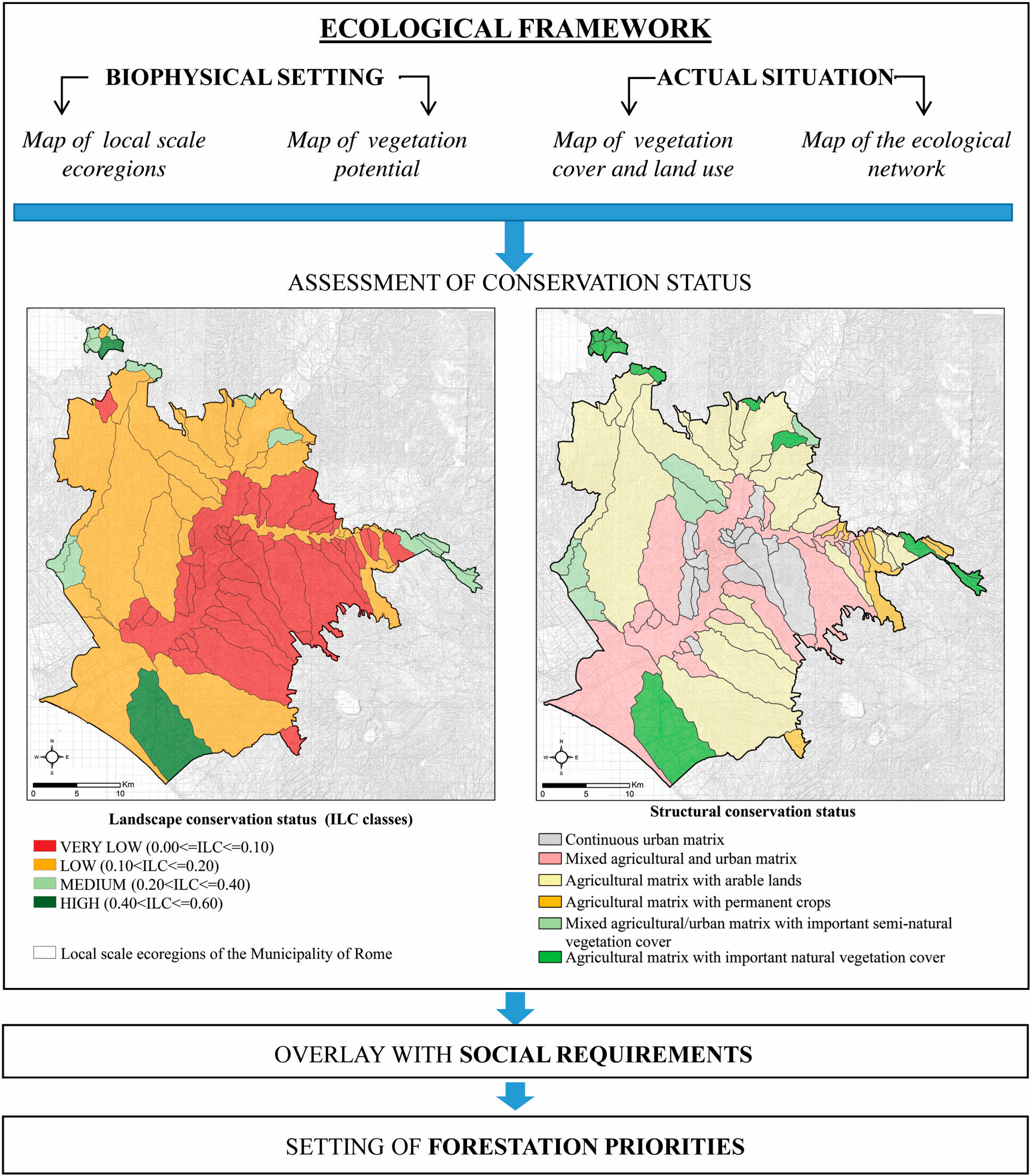
2.1. Foundation of Forestation Planning in the Metropolitan Area of Rome

The Municipality of Rome is a metropolis in the Mediterranean basin that covers an area of 1287 km2 with a population of 2,750,000 inhabitants. It is extraordinarily rich from both a historical and environmental point of view, and boasts a long history of biodiversity conservation and sustainable development [31,32]. Nevertheless, a considerable amount of pressure is being put on its urban and suburban ecosystems, which is also threatening the health and well-being of city dwellers. Main pressures and threats include soil consumption [33], air pollution [34], heat island effect [35], biological invasions [36], biodiversity loss, and landscape degradation [33,37].
A program aimed at increasing urban forest cover in metropolitan Rome was undertaken by the municipal administration (Municipal Deliberation n.82, 2009) within the framework of the master plan ecological network. As a prescriptive document, the master plan ecological network represents a policy response to the increasing threat on urban ecosystems through the legally binding regulation of relevant physical and functional transformations in the municipality. The network accounts for approximately 67% of the entire municipality and includes protected natural areas, public green urban areas, and agricultural lands. These components are classified as “primary”, “secondary” and “of completion”, according to their degree of naturalness and geographic continuity.
The forestation program was aimed at promoting ecological connectivity within the ecological network by means of restored nodes (biodiversity sources) and stepping stones (footholds for ecological flux of species, matter and energy) in order to enhance species and community biodiversity, to implement climate actions at the local level, and to improve functional integration between settled areas and environmental-agricultural systems. To provide a sound scientific basis for this initiative, the local government involved a group of university researchers, including the authors of the present work, to design an ecological framework for this program and coherently set forestation priorities.
The ecological framework for forestation in Rome was designed to identify a wide range of potential areas for long-term intervention, in which projects could be promptly implemented according to a number of carefully selected priorities, amounting to approximately 2000 ha (about 1.5% of the entire municipal area) (Figure 1 and Table 1).
Figure 1. Model for the design of the ecological framework and setting of forestation priorities in metropolitan Rome.
Sustainability 07 03958 g001
Table 1. Data for the design of the ecological framework and setting of forestation priorities in metropolitan Rome.
DataBasic informationDescriptionUtility for forestation planning
Vegetation cover and land useVegetation cover/land use map of Rome Municipality (scale 1:10,000)Cartographic representation of 44 classes of present land cover/land use, derived from photo-interpretation of panchromatic aerial photographs taken in 2001; the fifth level of the hierarchical legend includes five physiognomic classes of native forestsBasic information on the extent and distribution of land cover/land use and vegetation types that allows: (i) selection of potential areas for forest plantation; (ii) assessment of present conservation status in relation to the potential land cover; (iii) estimation of actual forest cover; and (iv) assessment of fragmentation within different land units
Local scale ecoregionsMap of geomorpho-ecological units (catchment basins, alluvial plains, delta plain, and dune systems) of Rome Municipality (scale 1:50,000) [28]Geographically defined and cohesive ecological units (ecoregions). They include portions of land with different vegetation potential but with functional connections (preferential exchange of species, matter and energy) and are characterized by a definite pattern of land cover and land use (landscape character)Within these discrete and relatively wide areas of the Municipality, an assessment of the conservation status of the different types of natural and semi-natural vegetation is useful
Vegetation potentialMap of the environmental units/areas of pertinence of the vegetation series of Rome Municipality (scale 1:20,000) [38]Typological units that can occur in different locations but display marked environmental homogeneity in terms of bioclimate, lithology and morphology; these units support 16 distinct types of vegetation potential (with possible different types of mature forest communities that share the same physiognomy) and related substitution communitiesEnvironmental baseline that can be used to assess and monitor the effects of natural dynamics and human activities; reference model for selecting woody species to be planted [39]
Landscape conservation statusMap of landscape conservation status of the geomorpho-ecological units of Rome MunicipalityRepresentation of the Index of Landscape Conservation (ILC) [40] for each of the local scale ecoregions. The ILC summarizes the environmental quality of land cover types in discrete land units according to the degree of soil sealing, impact of agricultural practices and distance of vegetation cover from the potential natural vegetation. The index varies between 0 (high level of artificialization) and 1 (high level of naturalness)Identification of the urban and suburban sectors with markedly damaged environmental quality
Structural conservation statusMap of structural conservation status of the geomorpho-ecological units of Rome MunicipalityComposition, prevalence and spatial arrangement of land cover types within each of the local scale ecoregionsDefinition of the landscape matrix and the assessment of actual ecological connectivity for the discrete urban and suburban sectors
Public farmsLocation of municipal farms and agricultural parks (provided by the Municipal Administration)Public farms and agricultural parks committed to the development of social agriculture, creation of youth employment and inclusion of disabled peopleRecognition of social priorities and opportunities for implementing biodiversity in agricultural areas
Degraded areasLocation of urban and suburban sectors affected by environmental degradation (provided by the Municipal Administration)Areas in which more urban green space is needed, or air, soil and water quality needs to be improvedIdentification of social priorities aimed at increasing accessible green spaces and improving environmental quality
Flood zones and areas for water resource managementHydrogeological Structure Plan of the Tiber River basin (provided by the Municipal Administration)Areas identified by the Basin Plan for sustainable use and management of water resourcesIdentification of priority areas for protection against floods and safeguard of water resources
The principles of landscape ecology [41], ecosystem geography [42] and dynamic plant sociology [43] were adopted as a scientific basis for the plan. Criteria that are consistent with these interdisciplinary approaches were agreed upon with the municipality staff so as to select the most appropriate ecological and social priorities within a narrow intervention area.

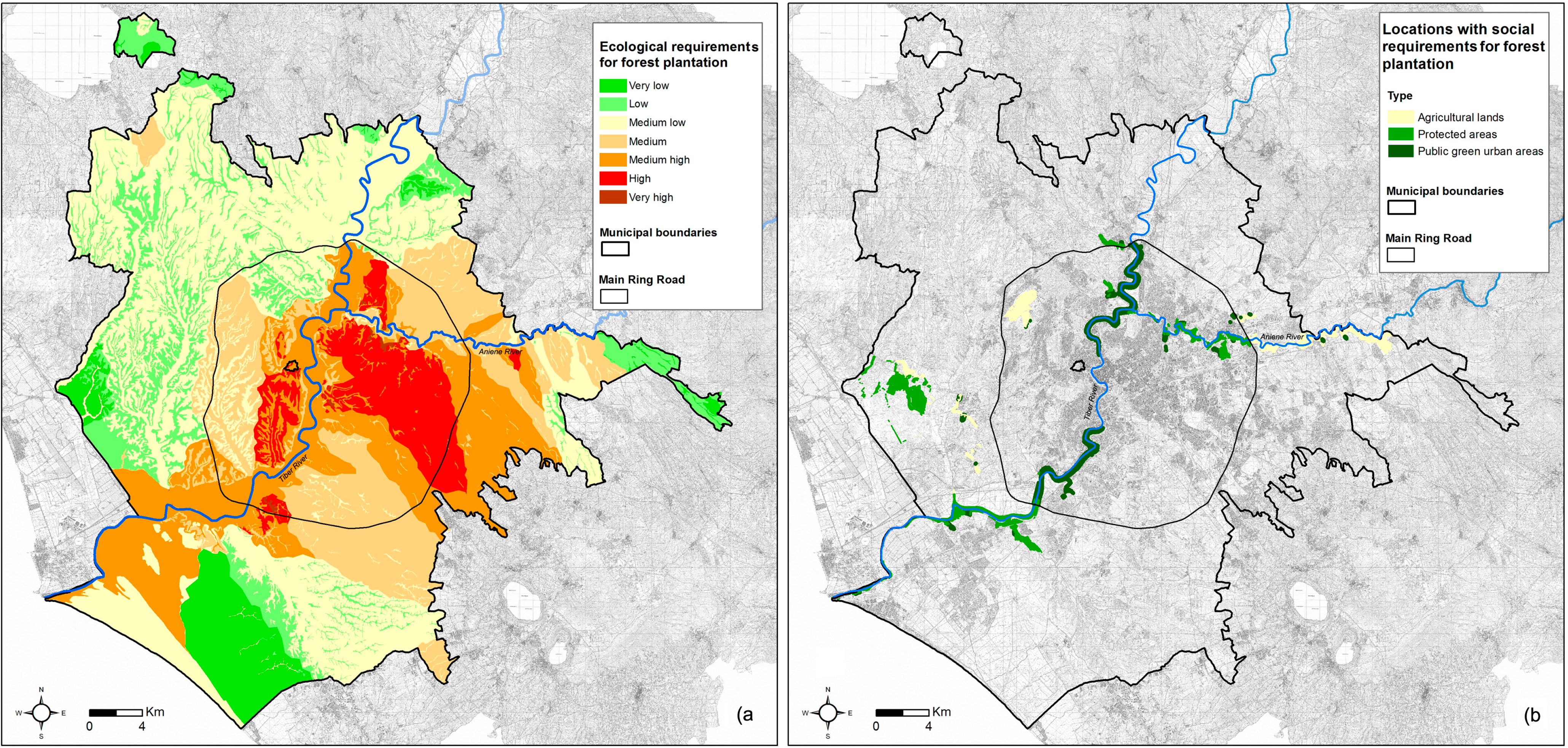
2.2. Criteria, Method and Basic Data for the Design of Forestation Ecological Framework

The ecological framework was first based on public green urban areas, agricultural lands and protected areas that make up the master plan ecological network. Potential areas for plantation were then extracted from these components according to the ecological suitability of the current land cover. Hence, we excluded: (i) public green urban areas below the minimum threshold of 0.5 ha, which was defined by the United Nations Framework Convention on Climate Change as the limit for acquiring carbon credits [44]; (ii) portions of continuous urban fabric, industrial, commercial and transport units, and archaeological sites, as they are not readily available areas; (iii) permanent crops, which represent agricultural areas of high value in terms of carbon sequestration, resistance against expansion of artificial surfaces and landscape quality; (iv) wetlands and inland waters, as they are already existing biodiversity hotspots and/or are inadequate for supporting forests; and (v) areas with current natural and semi-natural vegetation cover, because they already contribute to biodiversity conservation, landscape quality and ecological connectivity.
A set of stringent criteria was subsequently applied to identify geographic sectors of the municipality that mostly require forest plantation according to ecological needs, i.e., (1) improving ecosystem representativity; (2) restoring landscape quality; and (3) enhancing functionality of the ecological network. To assess these requirements, we integrated into a GIS environment (ArcGis 9.2) cartographic information on vegetation cover and land use, local scale ecoregions, vegetation potential (areas that are characterized by the same mature vegetation community and host the related vegetation series), landscape conservation status (based on current extent and environmental quality of existing land cover) and structural conservation status (based on structural and compositional parameters of land cover mosaic) (Table 1). Following the cartographic integration, geographic sectors with different ecological requirements for forest plantation were recognized according to the parameters in Table 2.
Specifically, we intersected local scale ecoregions, potential vegetation units, and actual vegetation cover to identify gaps in ecosystem representativity: potential vegetation units without any natural and semi-natural vegetation patch or green urban areas inside ecoregion boundaries were assessed as ambits within which forestation measures are critically required, followed by units with less than 10% actual natural and semi-natural vegetation cover (very high requirement), and units with less than 10% mature vegetation cover, even though semi-natural vegetation exceeds this threshold (high requirement).
For the second criterion, we considered the degree of artificialization/naturalness of local scale ecoregions obtained from the Index of Landscape Conservation (ILC) [30,40] (see also Table 1 and Figure 1 for a more detailed description and cartographic representation of the ILC). Ecoregions with a high degree of soil sealing and a strong impact of agricultural practices relate to low values of ILC and, hence, to high (ILC < 0.2) and very high (ILC ≤ 0.1) requirements for landscape restoration.
Table 2. Criteria, parameters and qualitative scores for recognizing geographic sectors with different ecological requirements for forest plantation. See Table 1 for the definition and description of potential vegetation units, ecoregions, landscape conservation status and Index of Landscape Conservation (ILC).
CriteriaParametersScore
(1) Improvement of ecosystem representativityVegetation potential units with more than 10% of natural forests inside ecoregion boundariesNot rated
Vegetation potential units with less than 10% of natural forests inside ecoregion boundaries+ (High requirement)
Vegetation potential units with less than 10% of natural forests, semi-natural vegetation and green urban areas inside ecoregion boundaries++ (Very high requirement)
Vegetation potential units without any natural forest, semi-natural vegetation or green urban area inside ecoregion boundaries+++ (Critical requirement)
(2) Restoration of landscape qualityEcoregions with “medium” up to “high” landscape conservation status (ILC > 0.2)Not rated
Ecoregions with “low” landscape conservation status (0.1 < ILC ≤ 0.2)+ (High requirement)
Ecoregions with “very low” landscape conservation status (ILC ≤ 0.1)++ (Very high requirement)
(3) Functional enhancement of the ecological networkEcoregions with prevailing “agricultural landscape matrix” and/or “important natural/semi-natural vegetation cover”Not rated
Ecoregions with “mixed urban/agricultural landscape matrix”+ (High requirement)
Ecoregions with “urban landscape matrix”++ (Very high requirement)
Regarding the third criterion, we considered the structural conservation status of local scale ecoregions, which was assessed according to percent coverage, number of patches, average dimension and mean distance between patches of the same land cover type (unpublished data, Figure 1). Intervention to enhance functionality of the ecological network was considered as: very highly required in ecoregions where artificial surfaces prevail and small agricultural patches and/or green urban areas are scattered within the urban landscape matrix; and highly required in ecoregions characterized by mixed urban/agricultural matrix with fragmented and distant natural and semi-natural vegetation patches.

2.3. Criteria, Method and Basic Data for Setting Forestation Priorities

To respond to the multiple needs posed by the municipal administration, we geographically located the following social requirements (Table 3): (4) improvement of agriculture sustainability; (5) restoration of degraded urban and suburban sectors; and (6) safeguard of water resources and flood areas.
Table 3. Criteria, parameters and qualitative scores for assessing social requirements for forest plantation. See Table 1 for the definition of public farms, degraded urban and suburban sectors, flood zones and areas for water resource management. Qualitative scores were assigned in agreement with the municipal administration.
CriteriaParametersScore
(4) Improvement of agriculture sustainabilityLands occupied by public farms+ (High requirement)
(5) Restoration of degraded urban and suburban sectorsDegraded neighborhoods or proximity to major pollution sources+++ (Critical requirement)
(6) Safeguard of water resources and flood areasFlood zones+ (High requirement)
By combining the ecological framework and social priorities, the array of potential areas for forestation could be ranked in classes of priority, which span from “extremely low”, i.e., potential areas in sectors without any stringent requirement for forest plantation, up to “extremely high”, i.e., potential areas in sectors with the maximum score for each of the ecological requirements and also interested by social requirements.
Potential areas with highest priority according to ecological and/or social requirements were selected to define short-term forestation priorities within the narrow intervention area posed by the municipal program. This final selection was derived by comparison with current implementation tools for urban planning, such as environmental protection restrictions, archaeological constraints, and already planned building and infrastructure constructions. Furthermore, an even geographic distribution among the different urban and suburban sectors of the metropolitan area was also taken into account.

3. Results

3.1. Ecological Framework of the Forestation Plan for the Municipality of Rome

Among the components of the master plan ecological network, a potential area amounting to 59,667 ha was recognized as suitable for forest plantation according to current land cover and minimum patch extent of 0.5 ha (Figure 3 and Table 4). It is mainly composed of agricultural lands (29,794 ha), protected areas (24,554 ha) and secondarily public green urban areas (5391 ha).
Figure 2a shows sectors of the Municipality with different requirements for forest plantation according to ecological criteria, i.e., ecosystem representativity, landscape quality and functionality of the ecological network.
An analytical report on the gaps in ecosystem representativity for each potential vegetation unit within different local scale ecoregions would overcome the purpose of this work. Nevertheless, using an overall assessment, it is possible to make a synthesis of the types of potential vegetation unit with very little natural and semi-natural vegetation cover at the municipal level. Types that in general present a very high requirement for forest plantation are: (i) fluvial terraces with vegetation potential for Quercus robur and Ulmus forests (5.9% of comprehensive vegetation cover) and (ii) alluvial coastal plains with vegetation potential for Fraxinus oxycarpa, Quercus robur, and riparian forests (7.6% of comprehensive vegetation cover). Types with high requirement for forest plantation, i.e., with less than 10% of actual natural forest cover are: (i) lava flows with vegetation potential for Quercus cerris and Q. virgiliana and locally Q. ilex forests (2.5% of actual forest cover); (ii) sandy hills with vegetation potential for Quercus virgiliana and Q. suber forests (3.4%); (iii) alluvial valleys with vegetation potential for Quercus robur, Alnus glutinosa, and riparian forests (4.8%); and (iv) ignimbritic plateaus and slopes with vegetation potential for Quercus cerris and Carpinus orientalis forests (5.1%).
Table 4. Total extent of components of the master plan ecological network, potential areas for forest plantation and selected short-term priorities.
Components of the master plan ecological networkAgricultural landsProtected areasPublic green urban areasTotal (ha)
Total extent (ha)36,65340,825686184,339
Potential areas for forest plantation according to suitable current land cover and minimum patch extent (ha)29,79424,554531959,667
Potential areas for forest plantation within sectors with recognized ecological requirements (ha)29,30022,590502056,910
Potential areas for forest plantation within or adjacent to locations with recognized social requirements (ha)87011914782539
Priority areas for forest plantation with highest ecological and/or social requirements (ha)1791678311289702
Selected short-term forestation priorities (ha)37310518452269
Figure 2. Sectors of the Municipality of Rome with different ecological requirements (a) and locations with social requirements (b).
Sustainability 07 03958 g002
The assessments of landscape and structural conservation status both show that not all local scale ecoregions of the city core (i.e., the sector within the Main Ring Road) are markedly affected by urban centrality. Ecoregions with a very low landscape conservation status largely prevail in the eastern part of the municipality (on the hydrographic left of the Tiber River) where they present a more widespread continuous urban matrix than the ecoregions of the western sector. Apart from some secondary hydrographic basins, a mixed agricultural and urban matrix characterizes the alluvial plain of the Tiber River and the coastal plain, the former showing a lower conservation status owing to its crossing of the city core.
Overall, the ecological requirements involve both urban and suburban sectors except for the northern zone, the coastal strip and the subcoastal ancient dune, which are all part of natural parks, and the easternmost edge of the municipality, which is characterized by unsuitable morphologies for land exploitation (i.e., a system of gorges). Sectors with ecological requirements involve 95% of the total potential areas for plantation (Table 4). However, areas with “very high” or “high” ecological requirements are very localized and prevail on the hydrographic left of the Tiber River. A similar distribution was found for the majority of areas with “medium high” or “medium” ecological requirements. The coastal alluvial plain of the Tiber River, which is entirely outside the city center, is characterized by a “medium high” ecological requirement for forest plantation.

3.2. Priority Areas for Forestation in the Municipality of Rome

Locations with social requirements have a narrow extent as they already derive from a selection of priorities made by the municipal administration (Figure 2b and Table 4). Public green areas show the major proportion of social requirements compared to the other ecological network components (9.0% of the respective potential areas for plantation). This finding is coherent with both the diffuse need to restore degraded urban sectors and the widespread flood zones of the Tiber River that cross the city core. Agricultural lands show a minor proportion of social requirements (2.9% of the respective potential areas for plantation), however, they meet all three criteria and represent almost the total of the locations with the specific requirement for mitigation of pollution. Potential areas for plantation with social requirements in protected areas account for 4.9% of the respective total and mainly concern flood zones.
Priority areas for forest plantation with the highest ecological and/or social requirements have an extent of 9702 ha and are mainly located within protected areas. This is due to the numerous nature reserves for the protection of undeveloped land within the city, which comprise not only residual natural ecosystems but also extensive agricultural areas. In accordance with the current implementation tools for urban planning, a subset of 2270 ha was selected from these priority areas and designated as strict forestation priorities to be realized in the short-term. It consists of 250 polygons (Figure 3), in both public (76%) and private (24%) ownership conditions, with an as much as possible balanced distribution between eastern and western sides and urban and suburban sectors of the metropolitan area. In particular, out of the total area of 2270 ha, 683 ha are mostly or partly devoted to improving ecosystem representativity, 1051 ha to restoring landscape quality, 102 ha to enhancing ecological connectivity, 540 ha to improving agriculture sustainability, 549 ha to restoring degraded urban sectors, and 971 ha to conserving and restoring flood zones and water bodies. Furthermore, each polygon always responds to more than one single criterion, thereby meeting the demand for multi-functionality imposed on green infrastructure elements. In particular, 157 out of 250 polygons have an “extremely high” priority as they obtained the highest score for at least one ecological and one social requirement; the remaining 93 polygons have a “high priority” as they show a minimum of two ecological or social requirements with the highest score for at least one of them.
Figure 3. Ecological framework and selected priorities for forest plantation in the Municipality of Rome.
Sustainability 07 03958 g003

4. Discussion

4.1. Expected Impact of the Forestation Plan for the Municipality of Rome at the Local Level

At the local level, the forestation plan for the Municipality of Rome represents an operative tool for the response to the multiple threats and pressures affecting biodiversity and the related provision of ecosystem services. Owing to intensive land exploitation, habitat fragmentation and pollution, local climate alteration, and the introduction of non-native species, a certain degree of environmental restoration is certainly needed across the whole metropolitan area. The design of the ecological framework and the selection of intervention priorities allow an effective focusing of sustainable planning initiatives.
The ecological framework covers an extensive portion of the Municipality (about 46%) and indicates ecological land units and urban and suburban sectors that mostly require restoration measures, even in the long-term, although not necessarily in the form of forest plantation. Potential vegetation units that lost most of their natural cover, i.e., the mature stages of vegetation series, prevalently belong to riverine systems, which range from alluvial terraces to alluvial valleys and coastal plain. This finding confirms the heavy transformation of floodplain landscapes that has been observed across all Europe [14] and validates the social priorities posed by the local administration for safeguarding water resources and mitigating floods. As for the improvement of these ecosystem services, selected areas for short-term intervention prevalently fall within public green areas and protected areas, thereby allowing extensive forest plantation without contrasting agricultural practices.
The ecological framework also pointed out the bad conservation status of the eastern side of the metropolitan area, which requires extensive restoration, especially throughout the ignimbritic plateau and the lava flows that characterize this area. The imbalance between the two sides of the Municipality is mainly due to the eastern orientation of the past and recent urban expansion, assisted by those favorable litho-morphologies, but also to the very scarce residual of forest cover in open areas. Recovering of mature vegetation is therefore a stringent priority in this sector, which is much more extensive than the selected areas for short-term intervention, and should prevalently restore degraded neighborhoods.
The western sector, on the other hand, showed overall better conditions except for the sandy hills, which include mine, dump and construction sites immediately outside the city core. Until recently, this sector hosted the largest dump in Europe, together with quarries and refineries and, therefore, the short-term priorities that concentrate here are prevalently devoted to mitigate environmental pollution. The rest of the western sector, with lower ecological requirements, is characterized by extensive agricultural lands and protected areas. In this case the ecological framework does not indicate a widespread need for forestation, but rather the implementation of agriculture sustainability through one or more of the possible greening measures defined by the new Common Agricultural Policy. Depending on specific socio-economic needs, different types of ecological focus areas, such as hedgerows, tree lines, bushes and wetlands, may provide more useful ecosystem services than forests in these places. Consequently, selected areas for short-term forestation in this sector mainly reflect the distribution of very critical zones for enhancement of ecological connectivity at the landscape level as well as the localized distribution of public farms, for which forest plantation may not represent a trade-off against primary production.

4.2. General Strength of the Forestation Plan for the Municipality of Rome

The approach here presented allowed the municipal master plan ecological network to move toward a more integrated green infrastructure. In fact, it contributes to the implementation of the multiple functions that green infrastructure are requested to perform apart from biodiversity conservation, i.e., improving ecosystem functioning, promoting ecosystem services, promoting societal well-being and health, and supporting the development of a green economy, and sustainable land and water management [45].
This methodology does not pretend to be exhaustive, for example it is more focused on restoration than on conservation, but rather aimed at identifying new nodes (or core areas) of the green infrastructure without considering ecological corridors. Furthermore, it is limited to the re-establishment of forest ecosystems without considering shrubland, grassland and wetlands and does not evaluate the improved provision of selected ecosystem services [46] according to the short-term planned interventions. Nevertheless, since ecological networks represent consolidated planning tools at different administrative levels in Europe [9,47,48], the approach followed for the metropolitan area of Rome represents a practical example of how to capitalize on existing planning instruments while addressing the present-day requests posed by the European Green Infrastructure Strategy. In particular, it contributes to effectively facing issues, such as multi-scale planning [17,49], adoption of nature-based solutions that are ecologically and biogeographically coherent [39], multi-functionality and spatial consistency between planned interventions and local demand for definite ecosystem services [50].
The multi-scale issue is addressed through the design of an ecological framework, which represents the landscape-level reference within which single sites for restoration can be coherently identified. The approach adopted for the forestation plan of Rome provided an opportunity to test and validate the effectiveness of the ecological classification of land, even in highly artificialized landscapes and within very restricted areas of intervention. Indeed, the underlying environmental features of land, such as physical substrata, morphology, macro- and meso-climatic conditions, indigenous vegetation communities, related ecosystems and ecological processes, are never totally suppressed in urban areas, particularly in metropolitan regions [51,52]. Although this natural setting is often altered, e.g., through ground and surface water governance, soil, air and water pollution, soil sealing, modification of topography, and habitat eutrophication, it preserves its main structural characteristics and ability to deliver ecosystem services in agricultural land, natural reserves and green spaces in both suburban and urban sectors [53,54]. Consequently, it is possible to detect and map distinct combinations of physical and biological environmental features that are found in different locations (ecoregions) [55] or that determine the occurrence of distinct types of vegetation potential (spatial domains of different vegetation series) [56] in metropolitan areas. Moreover, the mapping of potential vegetation units allows the identification of vegetation communities that may occur spontaneously within a given area. This provides key information on the most suitable native species to be planted and maintained in the long-term for ecological restoration purposes, thereby facilitating the adoption of nature-based solutions coherent with the ecological and biogeographical features of the intervention sites.
The process of spatial overlaying of different ecological and social requirements guarantees multi-functionality as well as spatial consistency of selected restoration sites. In fact, apart from the services provided by urban forests wherever they occur, such as carbon capture and regulation of the hydrological cycle, the explicit spatial setting of forestation priorities allows selected ecological requirements to directly join social demands, such as improvement of degraded neighborhoods and agriculture sustainability, at definite occurring locations.

5. Conclusions

The approach used to design the forestation plan of the Municipality of Rome enabled local planning to efficiently focus on stringent ecological and social requirements within the metropolitan area of a very extensive European capital. Analysis of the plan showed that sectors critically requiring forest plantation are above all located in the riverine systems and in the eastern urban and suburban neighborhoods. Riverine systems, which include alluvial terraces, alluvial plains and the coastal plain around the mouth of the Tiber River, are in fact those land units that suffered heavy losses of mature vegetation cover. Therefore, new forest patches at such locations are expected to considerably improve the provision of ecological benefits and, at the same time, enhance social well-being, safeguard water resources and increase resilience against floods. Similarly, within the eastern sectors of the municipality that show a bad conservation status in compositional and structural terms, restored forest patches are expected to improve the overall landscape quality with consequent benefits for both the ecosystem and human health.
Planned forests for mitigating environmental pollution have been carefully located and, especially in this case, indications provided by the local authorities played a determinant role in selecting priority sites. Furthermore, in the case of agricultural lands, the project was able to concretely face the need of a balanced restoration in primary production sectors within a metropolitan context, finding in public farms the ideal location within which it is possible to demonstrate the acquisition of ecological benefits provided by forests without clashing against the loss of direct profit from soil exploitation.
More in general, the approach exemplifies an effective transition from the ecological network planning tool toward the more recent concept of green infrastructure, which is at present actively promoted in the European Union. Specifically, the methodology we propose here allows forestation plans to meet a wide array of green infrastructure targets in urban contexts, besides the strict aim of biodiversity conservation. First, it integrates intervention priorities into a landscape scale perspective through the design of an overall ecological framework, which is assisted by the ecological classification of land. Second, it allows the restoration measures to meet the ecological and biogeographical features of the land through the identification and mapping of potential vegetation units, thereby safeguarding vegetation coherence and ensuring long-term persistence of restored habitats. Third, it facilitates effective investment of resources in ecological restoration to simultaneously provide multiple ecosystem services, with resultant benefits for both ecosystems and society, and finally it promotes spatial consistency between restored provision and actual demand for selected ecosystem services that need to be locally generated and consumed.

Acknowledgments

The authors wish to thank the Department for Environment Protection-Civil Protection of Rome Capital and Risorse per Roma RpR S.p.A. for their financial support, and Carlo Blasi, who is the scientific coordinator of the environmental basic research adopted for this work.

Author Contributions

Authors’ contributions: Giulia Capotorti led the work and wrote the manuscript; Giulia Capotorti, Barbara Mollo and Ilaria Anzellotti processed the data and generated the results; Laura Zavattero was involved in conceiving the methodology and conclusions, and contributed to drafting the overall article; Laura Celesti-Grapow coordinated the work and contributed to writing the article. All author have read and approved the final manuscript.

Conflicts of Interest

The authors declare no conflict of interest.

References

  1. De Oliveira, J.A.P.; Balaban, O.; Doll, C.N.H.; Moreno-Penaranda, R.; Gasparatos, A.; Iossifova, D.; Suwa, A. Cities and biodiversity: Perspectives and governance challenges for implementing the convention on biological diversity (CBD) at the city level. Biol. Conserv. 2011, 144, 1302–1313. [Google Scholar] [CrossRef]
  2. Säynäjoki, E.; Heinonen, J.; Junnila, S. The Power of Urban Planning on Environmental Sustainability: A Focus Group Study in Finland. Sustainability 2014, 6, 6622–6643. [Google Scholar] [CrossRef]
  3. Schewenius, M.; McPhearson, T.; Elmqvist, T. Opportunities for Increasing Resilience and Sustainability of Urban Social–Ecological Systems: Insights from the URBES and the Cities and Biodiversity Outlook Projects. Ambio 2014, 43, 434–444. [Google Scholar] [CrossRef] [PubMed]
  4. Crane, P.; Kinzig, A. Nature in the Metropolis. Science 2005, 308. [Google Scholar] [CrossRef]
  5. McPherson, E.G. Urban forestry in North America. Renew. Resour. J. 2006, 24, 8–12. [Google Scholar]
  6. Dearborn, D.C.; Kark, S. Motivations for Conserving Urban Biodiversity. Conserv. Biol. 2009, 24, 432–440. [Google Scholar] [CrossRef] [PubMed]
  7. Tzoulas, K.; Korpela, K.; Venn, S.; Yli-Pelkonen, V.; Kazmierczak, A.E.; Niemelä, J.; James, P. Promoting ecosystem and human health in urban areas using Green Infrastructure: A literature review. Landsc. Urban Plan. 2007, 81, 167–178. [Google Scholar] [CrossRef]
  8. Lovell, S.T. Multifunctional Urban Agriculture for Sustainable Land Use Planning in the United States. Sustainability 2010, 2, 2499–2522. [Google Scholar] [CrossRef]
  9. Jongman, R.H.; Külvik, M.; Kristiansen, I. European ecological networks and greenways. Landsc. Urban Plan. 2004, 68, 305–319. [Google Scholar] [CrossRef]
  10. Opdam, P.; Steingröver, E.; van Rooij, S. Ecological networks: A spatial concept for multi-actor planning of sustainable landscapes. Landsc. Urban Plan. 2006, 75, 322–332. [Google Scholar] [CrossRef]
  11. Benedict, M.A.; McMahon, E.T. Green Infrastructure; Island Press: Washington, DC, USA, 2006; pp. 1–299. [Google Scholar]
  12. Mell, I.C. Green infrastructure: Concepts and planning. FORUM Ejournal 2008, 8, 69–80. [Google Scholar]
  13. Maes, J.; Teller, A.; Erhard, M.; Liquete, C.; Braat, L.; Berry, P.; Egoh, B.; Puydarrieux, P.; Fiorina, C.; Santos, F.; et al. Mapping and Assessment of Ecosystems and Their Services. An Analytical Framework for Ecosystem Assessments under Action 5 of the EU Biodiversity Strategy to 2020; Publications Office of the European Union: Luxembourg, 2013; pp. 1–58. [Google Scholar]
  14. Schindler, S.; Sebesvari, Z.; Damm, C.; Euller, K.; Mauerhofer, V.; Hermann, A.; Biró, M.; Essl, F.; Kanka, R.; Lauwaars, S.; et al. Multifunctionality of floodplain landscapes: Relating management options to ecosystem services. Landsc. Ecol. 2014, 29, 229–244. [Google Scholar] [CrossRef]
  15. Forman, R.T.T.; Godron, M. Patches and structural components for a landscape ecology. BioScience 1981, 31, 733–740. [Google Scholar] [CrossRef]
  16. Bennett, G.; Jo Mulongoy, K. Review of Experience with Ecological Networks, Corridors and Buffer Zones; Technical Series No. 23; Secretariat of the Convention on Biological Diversity: Montreal, QC, Canada, 2006. [Google Scholar]
  17. Weber, T.; Allen, W.L. Beyond on-site mitigation: An integrated, multi-scale approach to environmental mitigation and stewardship for transportation projects. Landsc. Urban Plan. 2010, 96, 240–256. [Google Scholar] [CrossRef]
  18. Pataki, D.E.; Carreiro, M.M.; Cherrier, J.; Grulke, N.E.; Jennings, V.; Pincetl, S.; Pouyat, R.V.; Whitlow, T.H.; Zipperer, W.C. Coupling biogeochemical cycles in urban environments: Ecosystem services, green solutions, and misconceptions. Front. Ecol. Environ. 2011, 9, 27–36. [Google Scholar] [CrossRef]
  19. Lafortezza, R.; Davies, C.; Sanesi, G.; Konijnendijk, C.C. Green Infrastructure as a tool to support spatial planning in European urban regions. iForest Biogeosci. For. 2013, 6, 102–108. [Google Scholar] [CrossRef]
  20. Wolf, K.L.; Kruger, L.E. Urban Forestry Research Needs: A Participatory Assessment Process. J. For. 2010, 108, 39–44. [Google Scholar]
  21. Ordonez, C.; Duinker, P.N. Interpreting Sustainability for Urban Forests. Sustainability 2010, 2, 1510–1522. [Google Scholar] [CrossRef]
  22. Bolund, P.; Hunhammar, S. Ecosystem services in urban areas. Ecol. Econ. 1999, 29, 293–301. [Google Scholar] [CrossRef]
  23. Kenney, W.A.; van Wassenaer, P.J.E.; Satel, A.L. Criteria and Indicators for Strategic Urban Forest Planning and Management. Arboric. Urban For. 2011, 37, 108–117. [Google Scholar]
  24. Thompson, B.A. Planning for Implementation: Landscape-Level Restoration Planning in an agricultural Setting. Restor. Ecol. 2011, 19, 5–13. [Google Scholar] [CrossRef]
  25. Konijnendijk, C.C.; Ricard, R.M.; Kenney, A.; Randrup, T.B. Defining urban forestry—A comparative perspective of North America and Europe. Urban For. Urban Green. 2006, 4, 152–161. [Google Scholar] [CrossRef]
  26. Standish, R.J.; Hobbs, R.J.; Miller, J.R. Improving city life: Options for ecological restoration in urban landscapes and how these might influence interactions between people and nature. Landsc. Ecol. 2013, 28, 1213–1221. [Google Scholar] [CrossRef]
  27. Bailey, R.G. Ecoregions: The Ecosystem Geography of the Oceans and Continents; Springer-Verlag: New York, NY, USA, 1998. [Google Scholar]
  28. Blasi, C.; Capotorti, G.; Frondoni, R. Defining and mapping typological models at the landscape scale. Plant Biosyst. 2005, 139, 155–163. [Google Scholar] [CrossRef]
  29. Blasi, C.; Capotorti, G.; Copiz, R.; Guida, D.; Mollo, B.; Smiraglia, D.; Zavattero, L. Classification and mapping of the ecoregions of Italy. Plant Biosyst. 2014, 148, 1255–1345. [Google Scholar] [CrossRef]
  30. Capotorti, G.; Zavattero, L.; Anzellotti, I.; Burrascano, S.; Frondoni, R.; Marchetti, M.; Marignani, M.; Smiraglia, D.; Blasi, C. Do National Parks play an active role in conserving the natural capital of Italy? Plant Biosyst. 2012, 146, 258–265. [Google Scholar] [CrossRef]
  31. Blasi, C.; Capotorti, G.; Marchese, M.; Marta, M.; Bologna, M.A.; Bombi, P.; Bonaiuto, M.; Bonnes, M.; Carrus, G.; Cifelli, F.; et al. Interdisciplinary research for the proposal of the Urban Biosphere Reserve of Rome Municipality. Plant Biosyst. 2008, 142, 305–312. [Google Scholar] [CrossRef]
  32. Celesti-Grapow, L.; Capotorti, G.; Del Vico, E.; Lattanzi, E.; Tilia, A.; Blasi, C. The vascular flora of Rome. Plant Biosyst. 2013, 147, 1059–1087. [Google Scholar] [CrossRef]
  33. Frondoni, R.; Mollo, B.; Capotorti, G. A landscape analysis of land cover change in the Municipality of Rome (Italy): Spatio-temporal characteristics and ecological implications of land cover transitions from 1954 to 2001. Landsc. Urban Plan. 2011, 100, 117–128. [Google Scholar] [CrossRef]
  34. Manes, F.; Incerti, G.; Salvatori, E.; Vitale, M.; Ricotta, C.; Costanza, R. Urban ecosystem services: Tree diversity and stability of tropospheric ozone removal. Ecol. Appl. 2012, 22, 349–360. [Google Scholar] [CrossRef] [PubMed]
  35. Bonacquisti, V.; Casale, G.R.; Palmieri, S.; Siani, A.M. A canopy layer model and its application to Rome. Sci. Total Environ. 2006, 364, 1–13. [Google Scholar] [CrossRef] [PubMed]
  36. Celesti-Grapow, L.; Di Marzio, P.; Blasi, C. The importance of alien and native species in the urban flora of Rome (Italy). In Plant Invasions: Species Ecology and Ecosystem Management; Brundu, G., Brock, J., Camarda, I., Child, L., Wade, M., Eds.; Blackhuys Publisher.: Leiden, The Netherlands, 2001; pp. 209–220. [Google Scholar]
  37. Capotorti, G.; Del Vico, E.; Lattanzi, E.; Tilia, A.; Celesti-Grapow, L. Exploring biodiversity in a metropolitan area in the Mediterranean region: The urban and suburban flora of Rome (Italy). Plant Biosyst. 2013, 147, 174–185. [Google Scholar] [CrossRef]
  38. Blasi, C.; Capotorti, G. Carta delle serie di vegetazione del territorio del Comune di Roma (1:50.000). 2005. Available online: http://www.urbanistica.comune.roma.it (accessed on 10 November 2014).
  39. Biondi, E.; Blasi, C.; Allegrezza, M.; Anzellotti, I.; Azzella, M.M.; Carli, E.; Casavecchia, S.; Copiz, R.; Del Vico, E.; Facioni, L.; et al. Plant communities of Italy: The Vegetation Prodrome. Plant Biosyst. 2014, 148, 728–814. [Google Scholar] [CrossRef]
  40. Pizzolotto, R.; Brandmayr, P. An index to evaluate landscape conservation state based on land-use pattern analysis and Geographic Information System techniques. Coenoses 1996, 11, 37–44. [Google Scholar]
  41. Zonneveld, I. The land unit—A fundamental concept in landscape ecology, and its applications. Landscape Ecol. 1989, 3, 67–86. [Google Scholar] [CrossRef]
  42. Bailey, R.G. Ecosystem Geography: From Ecoregions to Sites, 2nd ed.; Springer: New York, NY, USA, 2009; p. 251. [Google Scholar]
  43. Rivas-Martinez, S. Notions on dynamic-catenal phytosociology as a basis of landscape science. Plant Biosyst. 2005, 139, 135–144. [Google Scholar] [CrossRef]
  44. Corona, P.; Fattorini, L.; Chirici, G.; Valentini, R.; Marchetti, M. Estimating forest area at the year 1990 by two-phase sampling on historical remotely sensed imagery in Italy. J. For. Res. 2007, 12, 8–13. [Google Scholar] [CrossRef] [Green Version]
  45. Science Communication Unit, the University of the West of England (UWE). The Multifunctionality of Green Infrastructure. Available online: http://ec.europa.eu/environment/nature/ecosystems/docs/Green_Infrastructure.pdf (accessed on 25 March 2015).
  46. Gómez-Baggethun, E.; Barton, D.N. Classifying and valuing ecosystem services for urban planning. Ecol. Econ. 2013, 86, 235–245. [Google Scholar] [CrossRef]
  47. Termorshuizen, J.W.; Opdam, P.; van den Brink, A. Incorporating ecological sustainability into landscape planning. Landsc. Urban Plan. 2007, 79, 374–384. [Google Scholar] [CrossRef]
  48. Blasi, C.; Zavattero, L.; Marignani, M.; Smiraglia, D.; Copiz, R.; Rosati, L.; del Vico, E. The concept of land ecological network and its design using a land unit approach. Plant Biosyst. 2008, 142, 540–549. [Google Scholar] [CrossRef]
  49. Allen, W.L. Advancing Green Infrastructure at All Scales: From Landscape to Site. Environ. Pract. 2012, 14, 17–25. [Google Scholar] [CrossRef]
  50. Burkhard, B.; Kroll, F.; Nedkov, S.; Müller, F. Mapping ecosystem service supply, demand and budgets. Ecol. Indic. 2012, 21, 17–29. [Google Scholar] [CrossRef]
  51. Kühn, I.; Brandl, R.; Klotz, S. The flora of German cities is naturally species rich. Evol. Ecol. Res. 2004, 6, 749–764. [Google Scholar]
  52. Ricotta, C.; Di Nepi, M.; Guglietta, D.; Celesti-Grapow, L. Exploring taxonomic filtering in urban environments. J. Veg. Sci. 2008, 19, 229–238. [Google Scholar] [CrossRef]
  53. Blasi, C.; Capotorti, G.; Marta, M.; Marchese, M. An integrated approach to better define the concept and functions of Urban Biosphere Reserves. Plant Biosyst. 2008, 142, 324–330. [Google Scholar] [CrossRef]
  54. Capotorti, G.; Frondoni, R.; Mollo, B.; Tilia, A.; Blasi, C. The contribution of plant sociology to the ecosystem service approach in urban and peri-urban areas: Evidences from a Mediterranean metropolis case study (Rome, Italy). Fitosociologia 2011, 48, 127–135. [Google Scholar]
  55. Blasi, C.; Capotorti, G.; Frondoni, R.; Guida, D.; Mollo, B.; Smiraglia, D.; Zavattero, L. Vegetation science and the ecoregional approach: A proposal for the ecological land classification of Italy. Fitosociologia 2011, 48, 67–80. [Google Scholar]
  56. Rosati, L.; Marignani, M.; Blasi, C. A gap analysis comparing Natura2000 vs. National Protected Area network with potential natural vegetation. Community Ecol. 2008, 9, 147–154. [Google Scholar] [CrossRef]

