Abstract
Virtual Field Trips (VFTs) have emerged as an alternative to Traditional Field Trips (TFTs), addressing logistical, financial, and accessibility constraints in geoscience education. This study presents a comparative analysis of the educational impact of a VFT and a TFT implemented with the same 10th-grade class in a Portuguese secondary school. The VFT, focused on volcanism and its socioeconomic impacts, used Google Earth to explore the island of São Miguel in the Azores. The TFT, centred on the rock cycle, was conducted at the Lavadores Beach geological site. Both interventions followed the field-based learning model by Orion and were structured around three phases: preparation, field trip (virtual or traditional), and post-activity synthesis. Data was collected through diagnostic tests, schematization, observation grids, student reports (snapshot), group projects, and written responses to a fieldwork guide recorded on Padlet during the VFT and TFT. The results showed that both VFTs and TFTs enhance conceptual understanding and student engagement, though they foster different skills: VFTs strengthen digital literacy, improve accessibility and inclusion for students with mobility or geographic constraints, allow for content revisitation, foster collaboration among students, integrate multimedia resources, and enable virtual exploration of remote locations that would otherwise be inaccessible. They also offer reduced costs, greater scheduling flexibility, and allow for individualised pacing of student learning. In contrast, TFTs provide richer sensory and practical experiences that are essential for hands-on scientific inquiry and foster stronger connections with the natural environment. The study concludes that a complementary use of both strategies offers the most inclusive and effective approach to teaching geosciences.
1. Introduction
Field-based learning is widely acknowledged as a cornerstone of geoscience education, as it promotes active engagement, situates theoretical concepts in real-world contexts, and supports long-term knowledge retention [1,2]. Traditional Field Trips (TFTs) allow students to observe geological features and processes directly in the environment where they occur. This multisensory immersion deepens conceptual understanding by linking abstract ideas to tangible evidence and fosters the development of practical skills such as mapping, sampling, measurement, and interpretation of spatial relationships [3]. Additionally, TFTs inherently demand collaboration, communication, and collective problem-solving, contributing to the development of transversal competencies that are essential for scientific literacy and informed decision-making in complex, real-world situations [4].
However, despite their pedagogical value, TFTs are not without limitations. They often require significant financial investment (e.g., transport, accommodation, and insurance), involve considerable logistical planning, depend on favourable weather conditions, and may exclude students with mobility constraints or specific learning needs [5,6].
In response to these barriers, Virtual Field Trips (VFTs) have emerged as an innovative and increasingly adopted alternative. They are supported by a range of digital technologies, including Google Earth, 3D photogrammetric outcrops, high-resolution panoramic imagery, and immersive virtual reality environments [7,8,9]. VFTs enable students to visit remote, hazardous, or geopolitically restricted sites that would otherwise be inaccessible. Moreover, virtual environments allow content to be revisited as many times as needed, supporting self-directed learning, differentiation, and personalised pacing while providing an archive of resources that can be used before, during, or after instruction [9,10,11,12]. Nevertheless, VFT do not replace the physical experience of fieldwork; they do not constitute a real research environment, nor do they permit the collection of physical samples, contextual sensory cues, or nuanced field observations that only emerge in situ [13].
The literature consistently demonstrates the benefits associated with VFTs, which include increased student motivation and engagement [14,15], development of digital competencies that are increasingly valued in scientific professions [16], and high adaptability to diverse educational settings, including large classes, non-formal education programmes, and distance learning [17]. However, several studies caution that VFTs, in isolation, cannot reproduce the tactile, sensory, and affective dimensions of traditional fieldwork that are crucial for geoscientific reasoning [18,19]. The lack of direct data collection opportunities may limit the development of investigative autonomy [20]. Furthermore, VFTs are dependent on stable technological infrastructure, which may reinforce digital inequities in contexts where internet access or technological resources are limited [18].
Recent research strongly indicates that the most effective pedagogical strategy is not to replace TFT with VFTs, but to integrate both within a complementary framework [19,21,22,23]. In this hybrid model, VFTs can function as a preparatory stage to introduce geological context, terminology, and conceptual challenges before students enter the field. This preparation increases cognitive readiness and frees cognitive load during TFT, allowing students to focus more deeply on observation, interpretation, and problem-solving. After returning from the field, VFTs can be used to revisit sites, clarify doubts, compare field notes, or extend the investigation through spatial analyses that were not possible during the actual trip. Thus, the combination of both modalities supports a continuous learning cycle that reinforces understanding before, during, and after field experiences.
From a pedagogical standpoint, integrating VFTs and TFT aligns with contemporary educational priorities, such as inclusion, curricular flexibility, and sustainability. VFTs broaden participation by removing financial, physical, and logistical barriers, while TFTs provide authenticity, sensory richness, and emotional engagement. This dual approach also fosters metacognition: students learn not only what to observe, but how and why observations matter in scientific reasoning. In addition, by combining digital and field-based methods, students develop hybrid 21st century skillsets that reflect current professional practice, where digital mapping, remote sensing, and GIS tools increasingly complement traditional field techniques.
Beyond learning outcomes, this integrated model carries broader implications for educational innovation and societal impact. By democratising access to field experiences and enhancing the quality of learning, VFT and TFT integration contributes to more equitable science education and supports the development of citizens who are capable of engaging critically with environmental and sustainability challenges. In the context of geosciences—where understanding Earth systems, natural hazards, and resource management is crucial—this pedagogical approach becomes not only educationally effective but socially relevant [24].
This study contributes to this debate by directly comparing the outcomes of a VFT and a TFT implemented with the same class of Portuguese secondary school students. The VFT addressed volcanism and its socioeconomic impacts in São Miguel Island (Azores), while the TFT focused on the rock cycle at Lavadores Beach (NW Portugal). Both interventions followed Orion’s [1] three-phase model (preparation, field trip, and synthesis). The following research question guided the study: How do VFTs and TFTs compare in promoting conceptual learning, engagement, and skill development in geoscience education?
2. Methodology
The study was conducted as action research, enabling the teacher–researcher to systematically plan, implement, observe, and reflect on both interventions. Action–research was selected as the methodological approach due to the context in which the studies were conducted, e.g., during initial teaching training. In this setting, the first two authors were trainee teachers who systematically evaluated their own practices while being fully integrated in the educational environment under investigation. Only one action–research cycle was carried out, as its duration was constrained by the length of the practicum (one school year). Nevertheless, the results obtained indicate clear potential for future action–research cycles to be implemented in subsequent studies.
This study adopted a mixed-methods research design within an action–research framework, combining qualitative and quantitative data to examine the educational impact of Virtual and Traditional Field Trips in geoscience education. Quantitative data include descriptive statistics derived from diagnostic tests, field guides, observation grids, schematizations, and grading scores, allowing for pre- and post-intervention comparisons. Qualitative data were obtained through content analysis of students’ drawings, written responses, digital posters, field notebooks, and open-ended items from snapshot reports. The integration of these complementary data sources enables a more comprehensive understanding of students’ conceptual learning, engagement, and skill development, strengthening the empirical basis of the study’s conclusions.
2.1. Sample
The study involved a class of 27 (n = 27) 10th-grade students (ages 15–16) enrolled in the Biology and Geology course at a secondary school in northern Portugal. The cohort displayed diverse learning styles and varying levels of interest in geosciences. All students participated in both interventions, ensuring the comparability of the results. The sample is one of convenience, as no generalisation is intended; rather, the aim is to gather indicators of how the two types of field trips may engage students in the learning process, collecting data on their advantages and limitations. The sample size reflects the specific context of an action–research study conducted during an initial teacher training practice session. While the limited sample size constrains the generalisability of the findings, the consistency observed across multiple data sources and instruments provides robust evidence of the pedagogical potential of a complementary VFT–TFT approach. Future studies should replicate this design with larger and more diverse samples to further validate these results.
2.2. Pedagogical Interventions
Two pedagogical interventions were implemented to explore students’ learning experiences through contrasting field-based approaches: a VFT and a TFT. Both activities were grounded in Orion’s three-phase model (preparation, fieldwork, and synthesis), aiming to foster conceptual understanding and engagement with geoscientific phenomena.
The aim of the article is to systematise the advantages and limitations of the two types of fieldwork and to explore their potential within a future blended teaching approach. The focus was not on the specific curricular content, but rather on the shared teaching strategy. As such, the study was conducted by two trainee teachers who were required to work on different thematic approaches, but with the same strategy—fieldwork.
The VFT centred on volcanism and its socioeconomic impacts on São Miguel Island (Azores), using Google Earth (version 7.3) and interactive digital tools to simulate an authentic fieldwork experience. Conversely, the TFT took place at Lavadores Beach (northwest Portugal), focusing on the rock cycle through direct observation, hands-on activities, and in situ data collection.
Each intervention integrated assessment, collaborative learning, and reflective synthesis, enabling a comparative analysis of how virtual and traditional field experiences support geoscience education.
2.2.1. Virtual Field Trip
The VFT addressed the theme of volcanism and its socioeconomic impacts on São Miguel Island, Azores. The activity was organised into three sequential phases.
- Phase 1: Preparation (100 min): this phase involved a diagnostic test to assess prior knowledge, an introductory lecture on the geological context, familiarisation with Google Earth tools, and the presentation of learning objectives.
- Phase 2: VFT (150 min): Students navigated through 17 georeferenced stops on Google Earth, integrating Street View imagery, multimedia resources, and guiding questions to support inquiry-based learning (Figure 1). Their responses were collaboratively recorded using Padlet, fostering peer interaction and reflection. Each group subsequently created a digital poster synthesising the key aspects of volcanic activity and its socioeconomic implications.
 Figure 1. Itinerary with the location of the 17 stops of the VFT on São Miguel Island, Azores (https://earth.google.com/earth/d/1coNlfwKnjwr_QVdWZ3hgvPBdXPDOy0fA?usp=sharing). (Image retrieved from software Google Earth version 7.3, accessed on 1 August 2025).Figure 1. Itinerary with the location of the 17 stops of the VFT on São Miguel Island, Azores (https://earth.google.com/earth/d/1coNlfwKnjwr_QVdWZ3hgvPBdXPDOy0fA?usp=sharing). (Image retrieved from software Google Earth version 7.3, accessed on 1 August 2025).
- Phase 3: Post-VFT synthesis (100 min): this final phase comprised a collective discussion of the field guide responses, group presentations of the digital posters, and the completion of a short perception survey to evaluate students’ experiences and insights.
2.2.2. Traditional Field Trip
The TFT took place at Lavadores Beach in northwest Portugal and focused on the rock cycle. It also followed Orion’s three-phase model, encompassing preparation, fieldwork, and synthesis.
- Phase 1: Preparation (100 min): This phase included a diagnostic test based on the schematization of the rock cycle, followed by hands-on activities involving the identification and classification of rock samples. Students were introduced to the geologist’s essential field tools (field notebook, compass, and hammer) and the planned itinerary, supported by preliminary exploration of the site through Google Earth.
- Phase 2: Field trip (150 min): During the fieldwork, students used a field guide containing the itinerary, geographic and geological framework of the site, and guiding questions for each stop (Figure 2). Individual virtual field notebooks were created using Padlet to document observations and reflections.
 Figure 2. Itinerary with the location of the 3 stops of the TFT on Lavadores Beach in NW Portugal (https://earth.google.com/earth/d/1ANdiNY2yuvzX9P9fi0P1tkFWdPy95F9q?usp=sharing) (Image retrieved from software Google Earth version 7.3, accessed on 1 August 2025).Figure 2. Itinerary with the location of the 3 stops of the TFT on Lavadores Beach in NW Portugal (https://earth.google.com/earth/d/1ANdiNY2yuvzX9P9fi0P1tkFWdPy95F9q?usp=sharing) (Image retrieved from software Google Earth version 7.3, accessed on 1 August 2025).
- Phase 3: Post-TFT synthesis (100 min): this final phase involved the collective correction of field guide responses, clarification of conceptual doubts in groups, completion of a worksheet and a diagram of the rock cycle, and administration of a brief perception survey to capture students’ reflections on the activity.
2.3. Data Collection Instruments
A range of instruments were employed to document students’ learning processes and experiences across both field trip modalities.
In the VFT, the following instruments were used for data collection: (i) a diagnostic test (Supplementary Materials A) an observation grid (Supplementary Materials B); and (iii) a snapshot report (Supplementary Materials C). All data were analysed qualitatively, and this included a content analysis of the fieldwork scripts completed during the visit and of the posters produced by the students in the post-field trip phase and in the classroom. In the VFT, the observation grids were used by both teachers and peer observers to evaluate students’ collaboration, engagement, and problem-solving strategies throughout the virtual exploration. Additionally, digital posters were created collaboratively by student groups to synthesise the main geological concepts and the socioeconomic implications of volcanic activity
In the TFT data were collected using the following instruments: (i) a rock cycle diagram (or drawing) produced in the first lesson and again in the third lesson (Supplementary Materials D); (ii) an analysis of records gathered using a fieldwork guide, which was used during the field lesson, as well as an analysis of digital records created in the Padlet software (version 222.2.0), which served as the pupils’ field notebook; and (iv) a snapshot report (Supplementary Materials E) completed in the final lesson of this IP’s implementation. All instruments were subjected to content analysis. In the TFT, students maintained a virtual field notebook, documenting their responses to field guide questions and recording field observations through annotated diagrams and sketches. Finally, the snapshot reports were administered at the end of each intervention to capture students’ perceptions regarding engagement, learning outcomes, and the accessibility of the learning experience.
The validity and reliability of the data collection instruments used in the implementation of this IP were ensured through their proper preparation and the selection of the content to be included. With the aim of legitimising their validity and reliability, they were developed in partnership with the cooperating teacher at the school and the supervising professor at the university, thereby ensuring their suitability for the sample involved in this research. Inter-observer consistency was ensured by having the same three observers complete the observation grids and conduct the analysis of the snapshot reports and the images produced by the students (the two pre-service teachers and their supervisor). Consistency was achieved through meetings held until consensus was reached among four evaluators—the three we have already mentioned and the university supervisor responsible for the pre-service teachers’ training programme.
2.4. Ethics
Informed consent was obtained from all participants and their guardians. Participation was voluntary, and anonymity and confidentiality were guaranteed throughout the process of data collection and analysis. The study was approved by the Ethics Committee of the Faculty of Sciences, University of Porto.
3. Results
This section presents the results from both the VFT and the TFT, showing how each approach supported students’ learning about geological processes.
3.1. Virtual Field Trip Results
3.1.1. Diagnostic Test
The diagnostic test carried out during the preparation phase revealed that students had limited prior knowledge of volcanism. The analysis of the drawings of the volcanic structure revealed varying levels of scientific accuracy and detail.
Only a small proportion of students (25.9%, n = 7) correctly represented all the main components of a volcano, including the magma chamber, volcanic conduit, volcanic crater, and volcanic cone. More than half of the students (51.9%, n = 14) included only some of these essential elements. Regarding the use of scientific vocabulary in the labels, 44.4% (n = 12) employed terminology appropriately. In terms of spatial organisation, 55.6% (n = 15) positioned the components in coherent locations and with realistic proportions. A smaller number of students (22.2%, n = 6) incorporated additional elements—such as pyroclasts, ash, gases, secondary craters, lava, or secondary cones—and correctly identified them. Finally, 25.9% (n = 7) oriented the arrows appropriately, pointing to the illustrated features rather than to the text, which contributed to greater visual clarity.
Drawings of the internal structure of a volcano reinforced this diagnosis (Figure 3):
- Several students misplaced elements such as the magma chamber, vent, and crater.
- Many drawings lacked proportionality and spatial consistency.
- Scientific terminology was often misused (e.g., “lava chamber” instead of “magma chamber”).

Figure 3.
Drawings of the internal structure of a volcano done by students.
Figure 3.
Drawings of the internal structure of a volcano done by students.

These findings confirmed a fragmented conceptual understanding, aligning with the importance of diagnostic assessments for adapting teaching strategies.
3.1.2. Field Guide and Digital Posters
During the VFT, students—organised into six groups—answered a total of 34 questions on the Padlet platform. An analysis of the responses revealed that 82.8% were correct (n = 28), 12.3% were incomplete (n = 4), 4.9% were incorrect (n = 2), and 0.0% remained unanswered (n = 0). These results represent a clear improvement when compared with the initial diagnostic test.
The digital posters produced by the student groups synthesised the main geological concepts addressed during the VFT and their socioeconomic implications (Figure 4), summarising the geological concepts explored during the VFT. The posters were assessed based on their scientific accuracy, organisation, creativity, and integration of digital resources. Groups 2 and 6 obtained an “Excellent” classification (19–20/20 points), while Groups 1, 3, 4 and 5 achieved “Very Good” classification (17–18/20 points).
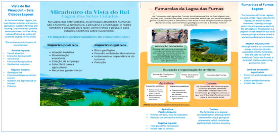
Figure 4.
Digital posters created by the students.
These results highlight the effectiveness of the VFT in promoting learning and the successful integration of scientific content into students’ final products.
3.1.3. Observation Grid
Three observers, namely the teacher–researcher and two colleagues, assessed students’ performance using a structured observation grid. The observation grid was applied to all students participating in the VFT (n = 27), and each student was assessed based on seven criteria organised into three domains: knowledge (C1), problem-solving (C2), and social skills (C3). For every criterion, absolute and relative frequencies were calculated.
No student (n = 0; 0.0%) was classified at level 1 (“insufficient”) or level 2 (“sufficient”). All classifications were therefore concentrated in level 3 (“good”) and level 4 (“excellent”), revealing overall high achievement and engagement throughout the activity.
In the knowledge domain (C1), the criterion “mobilisation of knowledge” (C1.1) showed that 24 students (88.9%) reached level 4 and 3 students (11.1%) reached level 3, indicating that almost all students were able to apply and contextualise scientific concepts during the fieldwork tasks. In the problem-solving domain (C2), the criterion “interpretation of the field guide questions” (C2.1) registered the maximum result, with all 27 students (100.0%) achieving level 4, consistently demonstrating an excellent understanding of the tasks proposed. The remaining criteria in this domain also revealed very positive outcomes: for “critical thinking” (C2.2), 21 students (77.8%) achieved level 4 and 6 (n = 6, 22.2%) were at level 3; for “creativity” (C2.3), 18 students (66.7%) reached level 4 and 9 (n = 9, 33.3%) reached level 3; and for “autonomy” (C2.4), 21 students (77.8%) were classified at level 4 and 6 (n = 6, 22.2%) at level 3. These results indicate that most students were able to think critically, propose original solutions, and work independently during the activity.
In the social skills domain (C3), the results were unanimous: 100.0% of the students reached level 4 (n = 27) in both “interest and participation” (C3.1) and “collaborative work” (C3.2), demonstrating high motivation, active involvement, and strong collaboration within the groups.
Overall, the distribution of frequencies demonstrates that the VFT successfully promoted scientific knowledge mobilisation, problem-solving skills, autonomy, and effective collaboration. The fact that 100.0% of the students reached level 3 or level 4 in all criteria confirms the strong pedagogical impact of the activity, with a predominant trend towards level 4 classifications.
The three observers (one active and two passive) recorded highly similar results, with consistent absolute frequencies across observers, reinforcing the reliability of the observation procedure.
3.1.4. Snapshot Report
To assess the impact of the VFT on students’ learning and to understand their perceptions of the methodology implemented, a snapshot report (composed of ten questions) was administered at the end of the instructional sequence. The questionnaire was completed voluntarily by all students in the class (n = 27, 100.0%).
The results indicate that almost all students (n = 26, 96.0%) had never participated in a VFT before, while only one student (n = 1, 4.0%) reported having participated in a VFT once in a previous school year. Despite their lack of prior experience, every student (n = 27, 100.0%) stated that they would participate in another VFT in the future.
Students’ perceptions of the activity were extremely positive. When asked to classify the overall experience, 63.0% (n = 17) considered it very interesting, and 37.0% (n = 10) considered it interesting (no negative evaluations were recorded). Regarding the perceived level of difficulty, 52.0% (n = 14) rated the activity as adequate, 33.0% (n = 9) as easy, and 15.0% (n = 4) as very easy. Concerning the contribution of the VFT to learning, 60.0% (n = 16) totally agreed that the activity helped to consolidate knowledge related to volcanism and its socioeconomic impacts in Portugal, 33.0% (n = 9) agreed, and only 7.0% (n = 2) remained neutral.
Students also identified the factors that would motivate them to participate in another VFT. The most selected reasons were the possibility of visiting remote or difficult-to-access sites (n = 26; 96.0%), the reduced cost of the activity (n = 24, 88.9%), and the possibility of visualising scientific concepts and revisiting the stops multiple times (n = 24, 88.9%). Other reasons included greater accessibility and inclusion (n = 19, 70.4%), ease of use and interactivity (n = 15, 55.6%), reduced travel time (n = 11, 40.7%), and reduced physical effort (n = 5, 18.5%). Students also strongly recognised the inclusive potential of the VFT: 85.2% (n = 23) totally agreed and 14.8% (n = 4) agreed that this educational resource promotes greater inclusion for learners who face geographical or physical constraints.
The open-ended questions reinforced these findings. Students highlighted the opportunity to explore São Miguel Island virtually (n = 15, 55.6%), the consolidation of content related to volcanism and its socioeconomic impacts (n = 14, 51.9%), and the possibility of visiting remote and inaccessible locations (n = 13, 48.1%) as the most interesting aspects. Most students reported no difficulties during the activity (n = 15, 55.6%), although some mentioned issues related to internet stability (n = 6, 22.2%) or time management (n = 5, 18.5%). Only one student (n = 1, 3.7%) referred to challenges associated with group coordination.
Overall, the results demonstrate that the VFT was perceived as an engaging and inclusive learning experience that effectively supported content consolidation while offering advantages that traditional fieldwork does not always provide.
3.2. Traditional Field Trip Results
3.2.1. Rock Cycle Schematization (Draws)
Pre-TFT Lesson
In this lesson, the rock cycle schematization (e.g., Figure 5) aimed to diagnose students’ misconceptions about it. Based on the analysis of the diagrams produced during this lesson, 92.6% (n = 25) of the students included igneous rocks in their representations, 55.6% (n = 15) included sedimentary rocks, and only 51.9% (n = 14) included metamorphic rocks. Regarding the processes associated with the formation of sedimentary rocks, 29.6% (n = 8) of the students referred to sediments, 3.7% (n = 1) mentioned weathering, 44.4% (n = 12) referred to erosion, 37.0% (n = 10) referred to transport, only 7.4% (n = 2) referred to sedimentation, and merely 3.7% (n = 1) referred to diagenesis. Furthermore, only 11.1% (n = 3) mentioned the process of metamorphism, which is essential for the formation of metamorphic rocks.
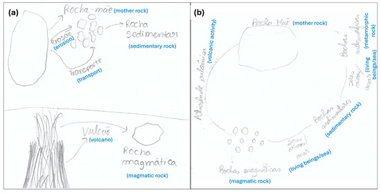
Figure 5.
(a) An example of a student who was unsuccessful in indicating the correct direction of the arrows, as these do not establish relationships between the different concepts. (b) An example of a student who did not indicate any direction using an arrow, instead using only a line to connect the different concepts. These diagrams either do not establish relationships among the different concepts or do not indicate any arrow direction (b).
Concerning the processes involved in the formation of igneous rocks, 22.2% (n = 6) mentioned magma in their diagrams, 3.7% (n = 1) referred to melting, and 18.5% (n = 5) referred to cooling. However, none of the students (0.0%, n = 0) mentioned crystallisation or solidification in their representations of the rock cycle. Regarding the direction of the arrows in the diagrams, 48.1% (n = 13) received a score of 0, indicating that they did not successfully represent the correct direction of the processes (Figure 5a).
The findings highlight that although students recognise some components of the rock cycle, they struggle to connect them through the correct processes, demonstrating the importance of continued scaffolding and conceptual reinforcement in subsequent lessons.
Post-TFT Lesson
Based on the analysis of the diagrams produced in this class (e.g., Figure 6), following the fieldwork activity, 100.0% (n = 27) of the students included igneous rock in their diagrams, 100.0% (n = 27) mentioned sedimentary rock and 96.3% (n = 26) represented metamorphic rock. Regarding the processes involved in the formation of sedimentary rocks, 11.1% (n = 3) of the students referred to sediments in their diagrams; 96.3% (n = 26) mentioned weathering, erosion, and transport; while only 11.1% (n = 3) indicated sedimentation and diagenesis. It is also noteworthy that 96.3% (n = 26) referred to the process of metamorphism, which is essential for the formation of metamorphic rocks.
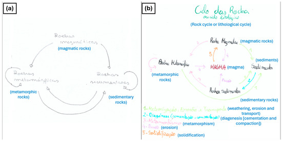
Figure 6.
(a) An example of a diagram with n = 0 arrows showing correct directionality, as the arrows do not relate the different rock types through geological processes, as intended; (b) an example of a rock cycle diagram with the highest score and the greatest number of arrows displaying correct directionality.
With respect to the processes involved in the formation of igneous rocks, 96.3% of the students (n = 26) mentioned magma in their diagrams, 85.2% (n = 23) referred to melting, 7.4% (n = 2) mentioned cooling, and 3.7% (n = 1) mentioned crystallisation, while 96.3% (n = 26) included solidification in their representations of the rock cycle. Regarding the direction of the arrows in the diagrams, only 3.7% (n = 1) received a score of 0 (Figure 5a). Conversely, 96.3% (n = 26) correctly represented between n = 4 (minimum) and n = 11 (maximum) arrows with appropriate directionality (Figure 5b). With respect to the processes involved in the formation of igneous rocks, 96.3% (n = 26) mentioned magma in their diagrams, 85.2% (n = 23) referred to melting, 7.4% (n = 2) cited cooling, and 3.7% (n = 1) mentioned crystallisation, while 96.3% (n = 26) indicated solidification in their representations of the rock cycle. Regarding the direction of the arrows in the diagrams, only 3.7% (n = 1) received a score of 0 (Figure 5a). Conversely, 96.3% (n = 26) correctly represented between n = 4 (minimum) and n = 11 (maximum) arrows with appropriate directionality (Figure 5b).
3.2.2. Field Guide and Virtual Field Notebook (Padlet)
During the field class itself, students were asked to complete three questions in the field guide and nine questions in the digital field notebook using the Padlet software (version 222.2.0). Both the field guide and the Padlet submissions were assessed according to evaluation criteria developed based on the correction rubric used for the synthesis lesson field guide. Each student’s combined field guide and Padlet activity received a score corresponding to a grading scale of 0 to 20. The average score obtained for the field guide and digital notebook was 16.1 out of 20.
As the statistical description indicates, the overall results were positive. Only 11.1% (n = 3) of the students obtained a failing grade, corresponding to 9 out of 20. In contrast, 88.9% (n = 24) of the students achieved a passing grade (≥10). Specifically, 18.5% (n = 5) of the students scored 14 points, 11.1% (n = 3) achieved 16 points, 14.8% (n = 4) obtained 17 points, 22.2% (n = 6) reached 18 points, 18.5% (n = 5) scored 19 points, and only 3.7% (n = 1) achieved the maximum score of 20 points.
3.2.3. Snapshot Report
At the end of the final class, students were asked to complete a snapshot report, which, through brief and concise responses, allowed us to assess their motivation, interest, and understanding of theoretical content via the field class.
The first question addressed students’ prior participation in field classes throughout their schooling. Based on the responses, it was found that only 3.7% (n = 1) had previously participated in field classes. This suggests that, for most students, the field class represented a new and distinct experience.
Regarding the field class itself, four questions were posed to evaluate the following factors: (i) comprehension of the rock cycle content through the application of theoretical knowledge, (ii) motivation for learning through fieldwork, (iii) interest in participating in similar activities again, and (iv) the impact of using a digital resource on motivation and interest in the content. The results indicated that no student (0.0%, n = 0) disagreed that the field class facilitated understanding of the rock cycle by enabling practical application of theoretical knowledge. One student (3.7%, n = 1) responded neutrally, while 48.1% (n = 13) agreed and 48.1% (n = 13) strongly agreed. Thus, 96.3% (n = 26) of students considered that the field class promoted comprehension of scientific content and the practical application of theoretical knowledge. Similarly, no student (0.0%, n = 0) reported being unmotivated by the fieldwork activity. In total, 96.3% (n = 26) of the students self-identified as motivated (33.3%, n = 9) or highly motivated (63.0%, n = 17), with only one student (3.7%, n = 1) responding neutrally.
Regarding interest in participating in future field classes, no student (0.0%, n = 0) reported no interest. However, 3.7% (n = 1) considered themselves slightly interested, and another 3.7% (n = 1) responded neutrally. Conversely, 22.2% (n = 6) were interested, and 70.4% (n = 19) reported being highly interested. Concerning the impact of digital resources on motivation and interest, 0.0% (n = 0) strongly disagreed, 14.8% (n = 4) disagreed, 14.8% (n = 4) responded neutrally, 37.0% (n = 10) agreed, and 33.3% (n = 9) strongly agreed. Therefore, 29.6% (n = 8) of students were either neutral or disagreed regarding the use of digital resources as a motivator, while 70.4% (n = 19) supported their use.
In the final snapshot question, students were asked to provide a short response reflecting on the fieldwork as an educational strategy, including what they enjoyed most, main difficulties, and potential suggestions for improvement. In response, 63.0% (n = 17) indicated that the field class enhanced their learning and understanding of the rock cycle. Regarding motivation and interest in the content being taught, 51.9% (n = 14) reported that the field class increased their motivation and interest in learning about the rock cycle. All students expressed what they enjoyed most about the field class: 70.4% (n = 19) highlighted the interaction with the environment and the on-site analysis of rocks; only 3.7% (n = 1) appreciated using the compass despite encountering difficulties; 7.4% (n = 2) enjoyed using Padlet as a digital field notebook; and 25.9% (n = 7) reported enjoying the class in general and/or expressed a desire to repeat the experience.
Some students also mentioned the aspects they liked least about the field class. For instance, 11.1% (n = 3) did not enjoy using Padlet, which aligned with the previous snapshot question where 14.8% (n = 4) disagreed that the use of a digital resource increased motivation and interest in the content. Since the digital field notebook required the use of students’ personal smartphones, one student (3.7%) quickly ran out of battery, highlighting a limitation of using such digital resources during field classes. The TFT required transportation between the school and the field site, which was carried out using public transport to minimise costs. Consequently, 7.4% (n = 2) of the students expressed dissatisfaction with the travel time required for the round trip between the school and Lavadores Beach, which was the location of the field class. Regarding the main difficulties encountered, 25.9% (n = 7) reported having had difficulty hearing or understanding the instructor during the field class. Only one student (3.7%, n = 1) reported fatigue, despite the field class including only three stops. Concerning the use of the compass, 7.4% (n = 2) reported difficulties. A small proportion, 7.4% (n = 2), experienced challenges in identifying rock types and understanding the questions in the digital field guide, citing the need for greater concentration due to the digital format of the notebook.
4. Discussion of Results
The data demonstrate that the VFT to São Miguel was an effective pedagogical intervention that achieved its intended objectives. Students showed a significant improvement in conceptual understanding, with correct responses increasing from 25.9% (n = 7) in the diagnostic test to 81.5% (n = 22) in the field guide activities. This progression confirms the potential of VFTs to foster cognitive gains when structured according to Orion’s (1993) model [1]. These findings align with previous studies that have highlighted the capacity of virtual approaches to enhance motivation and engagement through interactive and student-centred activities [11,12].
Beyond conceptual learning, the VFT promoted transversal skills such as collaboration, negotiation, and problem-solving, as evidenced in the observation grids. These outcomes corroborate recent research emphasising the role of active methodologies in fostering teamwork and student autonomy [4]. The use of Padlet and Google Earth proved particularly effective in developing digital literacy and creativity, confirming the pedagogical value of integrating digital tools into geoscience education [7]. Digital competences are being increasingly recognised as essential in contemporary education [12].
Another strength of the intervention was its inclusivity. VFTs reduce logistical and financial barriers, enabling participation from students who might otherwise face mobility or accessibility challenges [14]. They also allow content revisitation, flexible pacing, and access to places that would otherwise be unreachable [10,11]. These advantages reinforce the role of VFTs in democratising access to geoscience learning.
The specific context of São Miguel enriched the activity by introducing an interdisciplinary dimension. In addition to geological phenomena, students explored the socioeconomic impacts of volcanism, such as geothermal energy, tourism, agriculture, and the use of volcanic rocks in local architecture [18,25]. This Science–Technology–Society–Environment (STSE) approach connects scientific concepts with real-world issues, fostering critical citizenship.
Despite these strengths, certain limitations were identified. The first one is that the study sample is one of convenience, which indicates from the outset that the results cannot be generalised; rather, they should be used to obtain indicators regarding the response to the research questions.
Technical difficulties, including unstable internet connection and limited computer availability, slowed the progress of some activities. These challenges are consistent with the findings of Lege and Bonner (2020) [15], who argue that technological infrastructure is a prerequisite for the successful implementation of VFTs. Additionally, some interdisciplinary interpretations—such as explaining the ecological processes that influence lagoon colours—remained difficult for students, suggesting the need for further scaffolding. Importantly, VFTs cannot replicate the sensory immersion and hands-on inquiry that occur during TFTs [5,16], which remain irreplaceable for the development of field-based competences.
Overall, this study reinforces the increasing consensus that a hybrid approach is most effective [11,12]. By combining the accessibility and flexibility of VFTs with the authenticity and sensory richness of TFTs, educators can offer more inclusive and comprehensive geoscience education. This balanced strategy ensures that students not only acquire conceptual knowledge but also experience the natural environment directly, developing both digital and field competences that are essential in the 21st century.
The analysis of the rock cycle schematizations showed that, in the preparatory lesson, several students did not mention the key components of the rock cycle. Many diagrams did not include all three rock types, revealing alternative conceptions described by Francek (2012) [26]. The absence of links between processes indicated that students perceived the rock cycle as linear. These results are consistent with previous research on students’ misconceptions [26,27,28] and reinforce the relevance of diagnostic drawings in identifying students’ prior conceptions [29,30]. The sample was one of convenience and is therefore not representative.
In the synthesis schematization, learning progress was evident. All students mentioned igneous and sedimentary rocks, while only one student (3.7%) omitted metamorphic rock. Processes such as weathering, erosion, and transport were mentioned by 96.3% (n = 26) of the students compared to 44.4% (n = 12) in the preparatory lesson. Sedimentation and diagenesis remained less frequently mentioned, likely because these processes are less easily observable.
Metamorphism was identified by 96.3% (n = 26) of the students in the synthesis schematization, compared to 11.1% (n = 3) in the preparatory work. References to magma increased from 29.6% (n = 8) to 96.3% (n = 26), and melting increased from 3.7% (n = 1) to 85.2% (n = 23). Solidification, which was absent in the preparatory schematization (0.0%, n = 0), appeared in 96.3% (n = 26) of students’ work after the fieldwork. These improvements were linked to direct field observations.
Regarding the directionality of arrows connecting concepts and rock types, 48.1% (n = 13) of the students drew incorrect arrows during the preparatory lesson, whereas only 3.7% (n = 1) did so in the synthesis schematization—an improvement of 44.4% (n = 12). This indicates a clearer understanding of the interconnected nature of the rock cycle.
Concerning the field guide and digital field notebook, only three students achieved scores of less than 10 due to missing responses at the final stop. Conversely, 88.9% (n = 24) obtained scores between 14 and 20, demonstrating motivation and engagement. These findings are consistent with the findings of Guillaume et al. (2023) [19] and Harknett et al. (2022) [23].
The snapshot report showed that 96.3% (n = 26) of students had never participated in a TFT, highlighting organisational challenges such as bureaucracy, costs, scheduling, and permissions [1,31,32,33]. Likewise, 96.3% (n = 26) reported that the TFT helped mobilise and apply theoretical knowledge, with 63.0% (n = 17) expressing this in the open question. The same percentage—96.3% (n = 26)—reported increased motivation to learn through fieldwork, and 51.9% (n = 14) made a point of stating this explicitly, echoing the findings of Guillaume et al. (2023) [19].
Regarding future participation in fieldwork, 92.6% (n = 25) of students stated they were interested or very interested. The impact of digital resources generated more diverse responses: 70.4% (n = 19) considered the digital tools motivational, although only 7.4% (n = 2) mentioned this explicitly. Conversely, 29.6% (n = 8) did not consider the tools motivating, with 11.1% (n = 3) stating this in writing. This may reflect students’ unfamiliarity with field-based methodologies, as many expected a more passive experience. However, field-based learning requires active engagement [34] and the field notebook—digital or paper—is essential to document observations [35].
5. Conclusions
The VFT to São Miguel Island demonstrated itself as an effective and innovative pedagogical tool for geoscience education. The activity not only achieved the intended objectives but also went beyond them by fostering student motivation, autonomy, and engagement with scientific content.
The results confirmed an improvement in conceptual understanding, as evidenced by the comparison between diagnostic test scores and responses in the field guide. Students showed the ability to mobilise geological concepts in authentic contexts, demonstrating deeper comprehension of volcanic phenomena and their socioeconomic implications. Furthermore, the production of digital posters revealed creativity, scientific rigour, and the capacity to integrate knowledge across disciplines. In addition to cognitive learning, the VFT promoted the development of transversal skills such as collaboration, negotiation, decision-making, and problem-solving. These competences were clearly observed in the structured observation grids and were also highlighted in students’ reflections. The integration of digital tools like Google Earth and Padlet proved particularly valuable, reinforcing digital literacy and inclusivity and enabling content revisitation at each student’s own pace. Despite the overall success, some limitations were identified. Technical constraints, including limited internet connectivity and insufficient availability of computers, hindered the smooth progression of activities. Moreover, certain interdisciplinary aspects, such as linking geological and ecological interpretations, remained challenging for some students. These findings point to the importance of adequate infrastructure and time allocation in future implementations.
The results of this study regarding the TFT indicate that students felt more engaged in their learning about the rock cycle, expressing motivation and interest in scientific content both during and after the field lesson. The commitment demonstrated by students throughout the various lessons was highly positive, with consistent participation and interest, resulting in generally strong outcomes. The field lesson facilitated the development of several competencies, including spontaneous collaborative work, in which students naturally collaborated with one another, as well as investigative skills in the field context, such as observation and sample collection. Additionally, it fostered awareness of the magnitude of geological processes, both in spatial and temporal terms, as students were able to witness multiple processes occurring in situ. In this way, TFT represents a teaching and learning methodology that promotes an integrated understanding of the geosciences. However, some students experienced difficulties keeping up with the field class while simultaneously reporting observations in the digital field notebook. The digital tool implemented during the field class elicited mixed reactions—while some students reported that it facilitated learning and increased motivation, a minority expressed dissatisfaction, finding it challenging to observe in situ and record their observations digitally.
In conclusion, this study validates the pedagogical potential of VFTs as an inclusive, accessible, and engaging strategy for teaching and learning in geosciences. By reducing logistical barriers and enhancing digital skills, VFTs complement TFTs, which remain irreplaceable for hands-on inquiry and direct contact with the natural environment. Virtual Field Trips have emerged as valuable tools for fostering inclusion, providing immersive geological learning experiences for students who may face physical, geographical, or socioeconomic barriers to participating in traditional fieldwork. In this sense, both forms of field-based exploration can be viewed as complementary and may be effectively integrated within a blended-learning framework to enrich the overall teaching and learning process. This study highlights the potential of both types of field trip and notes that, when used together, they may be complementary; however, further studies are clearly required to draw more robust conclusions.
Supplementary Materials
The following supporting information can be downloaded at: https://www.mdpi.com/article/10.3390/su18020781/s1.
Author Contributions
Conceptualization, A.R. and P.A.; methodology, C.V.; validation, T.R. and C.V.; formal analysis, A.R. and P.A.; investigation, A.R. and P.A.; writing—original draft preparation, A.R. and P.A.; writing—review and editing, T.R.; supervision, C.V. All authors have read and agreed to the published version of the manuscript.
Funding
This research was funded by national funds through FCT—Fundação para a Ciência e a Tecnologia, I.P., and by the European Commission’s Recovery and Resilience Facility, within the scope of UID/04423/2025 (https://doi.org/10.54499/UID/04423/2025), UID/PRR/04423/2025 (https://doi.org/10.54499/UID/PRR/04423/2025), and LA/P/0101/2020 (https://doi.org/10.54499/LA/P/0101/2020).
Institutional Review Board Statement
The study was conducted in accordance with the Declaration of Helsinki, and approved by the Ethics Commission of the Faculty of Science of Porto University (protocol code: CE2025/p202, CE2025/p217; date of approval: 12 February 2025 and 28 February 2025).
Informed Consent Statement
Informed consent was obtained from all subjects involved in the study.
Data Availability Statement
Data is unavailable due to privacy or ethical restrictions.
Conflicts of Interest
The authors declare no conflicts of interest.
Abbreviations
The following abbreviations are used in this manuscript:
| TFT | Traditional Field Trip. |
| VFT | Virtual Field Trip. |
References
- Orion, N. A model for the development and implementation of field trips as an integral part of the science curriculum. Sch. Sci. Math. 1993, 93, 325–331. [Google Scholar] [CrossRef]
- Orion, N.; Hofstein, A. Factors that influence learning during a scientific field trip in a natural environment. J. Res. Sci. Teach. 1994, 31, 1097–1119. [Google Scholar] [CrossRef]
- Nyarko, S.; Petcovic, H. Do students develop teamwork skills during geoscience fieldwork? A case study of a hydrogeology field course. J. Geosci. Educ. 2022, 71, 145–157. [Google Scholar] [CrossRef]
- Sølvberg, A.; Rismark, M. Student collaboration in student active learning. Int. Conf. Future Teach. Educ. 2023, 2, 74–81. [Google Scholar] [CrossRef]
- Cliffe, A.D. A review of the benefits and drawbacks to virtual field guides in today’s geoscience higher education environment. Int. J. Educ. Technol. High. Educ. 2017, 14, 28. [Google Scholar] [CrossRef]
- Horota, R.K.; Eide, C.H.; Senger, K.; Jonassen, M.O.; Kloet, M.A.V. Digital field representations as a holistic approach to experiential learning in High Arctic geoscience field education. EGUsphere 2025, 1–26. [Google Scholar] [CrossRef]
- Bond, C.E.; Cawood, A.J. The role of Google Earth in teaching geoscience. Geosphere 2021, 17, 120–134. [Google Scholar] [CrossRef]
- Whitmeyer, S.J.; Dordevic, M. Creating Virtual Geologic Mapping Exercises in a Changing World. Geosphere 2021, 17, 226–243. [Google Scholar] [CrossRef]
- Rodríguez-Santalla, I.; Martín, S.; Crespo, T.; Gomez-Ortiz, D.; Abad, M.; Fraguas, Á.; López, J.; Felgueras Custodio, N.; Izquierdo, T.; Jiménez-Díaz, A. Herramientas digitales para el aprendizaje inclusivo: Virtualización de la práctica de campo de la geología. Geotemas 2024, 20, 553–556. [Google Scholar]
- Mead, C.; Buxner, S.; Bruce, G.; Taylor, W.; Semken, S.; Anbar, A.D. Immersive, interactive virtual field trips promote science learning. J. Geosci. Educ. 2019, 67, 131–142. [Google Scholar] [CrossRef]
- Evelpidou, N.; Karkani, A.; Komi, A.; Giannikopoulou, A.; Tzouxanioti, M.; Saitis, G.; Spyrou, E.; Gatou, M.-A. GIS-based virtual field trip as a tool for remote education. Geosciences 2022, 12, 327. [Google Scholar] [CrossRef]
- Ribeiro, T.; Paz, M.; Vasconcelos, C. Virtual field trips in natural sciences education: Advantages, challenges, and a practical application in Portugal. In Proceedings of the 11th SWS International Scientific Conference on Social Sciences (ISCSS 2024), Varna, Bulgaria, 27–30 August 2024; pp. 349–356. [Google Scholar] [CrossRef]
- Leininger-Frézal, C.; Sprenger, S. Virtual field trips in binational collaborative teacher training: Opportunities and challenges in the context of education for sustainable development. Sustainability 2022, 14, 12933. [Google Scholar] [CrossRef]
- Han, I. Immersive virtual field trips in education: A mixed-methods study on elementary students’ presence and perceived learning. Br. J. Educ. Technol. 2020, 51, 420–435. [Google Scholar] [CrossRef]
- Lege, R.; Bonner, E. Virtual reality in education: The promise, progress, and challenge. JALT CALL J. 2020, 16, 167–180. [Google Scholar] [CrossRef]
- Houghton, J.J.; Lloyd, G.E.; Robinson, A.; Gordon, C.E.; Morgan, D.J. The Virtual Worlds Project: Geological mapping and field skills. Geol. Today 2015, 31, 227–231. [Google Scholar] [CrossRef]
- Barth, N.C.; Stock, G.M.; Atit, K. From a virtual field trip to geologically reasoned decisions in Yosemite Valley. Geosci. Commun. 2022, 5, 17–28. [Google Scholar] [CrossRef]
- Gaspar, J.L.; Guest, J.E.; Duncan, A.M.; Barriga, F.J.A.S.; Chester, D.K. Volcanic Geology of São Miguel Island (Azores Archipelago); Memoirs; The Geological Society: London, UK, 2015; Volume 44, pp. 1–3. [Google Scholar] [CrossRef]
- Guillaume, L.; Laurent, V.; Genge, M.J. Immersive and interactive three-dimensional virtual fieldwork: Assessing the student learning experience and value to improve inclusivity of geosciences degrees. J. Geosci. Educ. 2023, 71, 462–475. [Google Scholar] [CrossRef]
- Medeiros, J.; Carmo, R.; Pimentel, A.; Vieira, J.C.; Queiroz, G. Assessing the impact of explosive eruptions of Fogo volcano (São Miguel, Azores) on the tourism economy. Nat. Hazards Earth Syst. Sci. 2021, 21, 417–437. [Google Scholar] [CrossRef]
- Orion, N.; Bem-Shalom, R.; Ribeiro, T.; Vasconcelos, C. Geoethics in fieldtrips: A global geoethical perspective. In Teaching Geoethics: Resources for Higher Education; Vasconcelos, C., Schneider-Voß, S., Peppoloni, S., Eds.; U.Porto Edições: Porto, Portugal, 2020; pp. 111–132. [Google Scholar] [CrossRef]
- Vasconcelos, C.; Pinto, T. Nature-based solutions and the decline of pollution: Solving problems to learn sustainable development goals. Educ. Sci. 2023, 13, 1135. [Google Scholar] [CrossRef]
- Harknett, J.; Whitworth, M.; Rust, D.; Krokos, M.; Kearl, M.; Tibaldi, A.; Bonali, F.L.; Van Wyk de Vries, B.; Antoniou, V.; Nomikou, P.; et al. The use of immersive virtual reality for teaching fieldwork skills in complex structural terrains. J. Struct. Geol. 2022, 163, 104681. [Google Scholar] [CrossRef]
- Ribeiro, T.; Vasconcelos, C. Earth system science and education: From foundational thoughts to geoethical engagement in the Anthropocene. Geosciences 2025, 15, 224. [Google Scholar] [CrossRef]
- Franco, A.; Ortolá, R.; Ponte, C.; Guimarães, T. Sustainable use of geothermal resources in the Ribeira Grande geothermal field, São Miguel, Azores. Comun. Geológicas 2020, 107, 93–96. [Google Scholar]
- Francek, M. A compilation and review of over 500 geoscience misconceptions. Int. J. Sci. Educ. 2012, 35, 31–64. [Google Scholar] [CrossRef]
- King, C.J.H. An analysis of misconceptions in science textbooks: Earth science in England and Wales. Int. J. Sci. Educ. 2009, 32, 565–601. [Google Scholar] [CrossRef]
- Provost, A.; York, T.; San Lim, S.; Panorkou, N. Orchestrating students’ systems thinking about the rock cycle. In ISLS—International Society of the Learning Sciences; International Society of the Learning Sciences: Bloomington, IN, USA, 2023; pp. 1182–1185. [Google Scholar] [CrossRef]
- Dempster, E.; Stears, M. An analysis of children’s drawings of what they think is inside their bodies: A South African regional study. J. Biol. Educ. 2014, 48, 71–79. [Google Scholar] [CrossRef]
- Nyachwaya, J.M.; Mohamed, A.-R.; Roehrig, G.H.; Wood, N.B.; Kern, A.L.; Schneider, J.L. The development of an open-ended drawing tool: An alternative diagnostic tool for assessing students’ understanding of the particulate nature of matter. Chem. Educ. Res. Pract. 2011, 12, 121–132. [Google Scholar] [CrossRef]
- Almeida, P.; Barros, J.; Cruz, N. Conceções e práticas de professores de geologia sobre trabalho de campo. Enseñanza Cienc. 2013, 47–53. [Google Scholar]
- Barros, J.F.; Almeida, P.A.; Cruz, N. Fieldwork in geology: Teachers’ conceptions and practices. Procedia—Soc. Behav. Sci. 2012, 47, 829–834. [Google Scholar] [CrossRef]
- Dourado, L.; Leite, L. Atividades de campo no ensino da geologia: Opiniões de professores portugueses sobre formas ideais de as usar. Rev. Int. Formação Profr. 2016, 1, 10–35. [Google Scholar]
- Vasconcelos, C.; Ribeiro, T. The interplay of geoheritage and outdoor experiences through education and communication. In Geoheritage: Assessment, Protection, and Management, 2nd ed.; Reynard, E., Brilha, J., Eds.; Elsevier: Amsterdam, The Netherlands, 2026; pp. 411–430. [Google Scholar] [CrossRef]
- Compiani, M. A relevância das atividades de campo no ensino de geologia na formação de professores de Ciências. Cad. IG/UNICAMP 1991, 1, 2–25. [Google Scholar]


Disclaimer/Publisher’s Note: The statements, opinions and data contained in all publications are solely those of the individual author(s) and contributor(s) and not of MDPI and/or the editor(s). MDPI and/or the editor(s) disclaim responsibility for any injury to people or property resulting from any ideas, methods, instructions or products referred to in the content. |
© 2026 by the authors. Licensee MDPI, Basel, Switzerland. This article is an open access article distributed under the terms and conditions of the Creative Commons Attribution (CC BY) license.