Article

Analysis and Optimization Prioritization of School Routes in Mountainous Cities Based on Child-Friendly Principles: A Case Study of Chongqing

1
College of Landscape Architecture and Art, Northwest A&F University, Yangling 712100, China
2
College of Water Resources and Architectural Engineering, Northwest A&F University, Yangling 712100, China
*
Author to whom correspondence should be addressed.
These authors contributed equally to this work.
Sustainability 2025, 17(9), 3936; https://doi.org/10.3390/su17093936
Submission received: 14 March 2025 / Revised: 13 April 2025 / Accepted: 24 April 2025 / Published: 27 April 2025

Abstract

:
This study addresses the critical gap in designing child-friendly school commuting routes in mountainous cities like Chongqing, where steep terrain and complex infrastructure pose unique challenges to children’s safety and accessibility. Combining Importance-Performance Analysis (IPA) and the Kano model, we systematically evaluated 19 design elements across safety, interest, and convenience dimensions through comprehensive field research and surveys involving 611 participants. Our analysis identified emergency signage systems, street greening, and parent pick-up points as pivotal optimization factors, while revealing significant improvement needs for vehicle speed limits and anti-slip pavement. The findings demonstrate how context-specific, evidence-based design solutions can effectively enhance children’s commuting experiences in challenging urban environments, providing urban planners with a scientifically-grounded framework that adapts child-friendly principles to mountainous contexts. This research advances the field of child-friendly urban planning by bridging the current theoretical-practical divide and offering actionable strategies tailored to geographically constrained cities.

1. Introduction

The concept of child-friendliness originates from the United Nations Convention on the Rights of the Child, emphasizing that children should enjoy equal rights to urban spaces as adults during their lives, growth, and development. With the acceleration of global urbanization, children’s living environments face increasingly severe challenges, particularly in highly urbanized settings where they are often marginalized in urban spaces. Public spaces, as open areas for various social interactions, serve as crucial platforms for implementing child-friendly principles and promoting children’s activities. A child-friendly city not only focuses on children’s living conditions but also prioritizes their needs in mobility, recreation, education, and more [1]. The concept of child-friendliness extends beyond the adaptability of physical environments to include psychological and emotional security and a sense of belonging. Children’s development is deeply intertwined with their surroundings, especially the design and allocation of spaces related to transportation, education, health, and social interaction. By studying child-friendliness, we can gain a deeper understanding of the specific challenges children face in urban life, particularly in terms of traffic safety, accessibility of public facilities, and the allocation of green spaces. Thoughtful urban design can improve children’s physical and mental well-being, mitigate the negative impacts of urbanization, and foster harmonious interactions between children and urban spaces. Therefore, designing child-friendly cities is essential for sustainable human development. Child-friendly cities encourage children to grow up in healthy, safe, and supportive environments [2].
In contemporary society, parents have placed unprecedented emphasis on the safety and convenience of their children’s school commuting routes. This concern stems not only from a profound interest in the individual growth environment of children but also reflects the proactive aspirations of families, as fundamental units of society, for constructing harmonious and secure community environments. With the continuous advancement of educational philosophy and the widespread enhancement of social safety awareness, an increasing number of parents are scrutinizing and optimizing their children’s school commuting routes, aiming to create a more autonomous and secure environment for them during their commutes. Against this backdrop, exploring how parents, based on meticulous considerations of their children’s school commuting routes, gradually establish trust and assurance in their children’s ability to commute independently, has emerged as a noteworthy educational and sociological research topic. This study aims to analyze parents’ psychological changes, behavioral strategies, and the long-term impact on children’s independence cultivation during this process, in order to provide theoretical support and practical guidance for establishing a more comprehensive child school commuting support system.
With the accelerated urbanization of mountainous regions in China, an emphasis on rapid development at the expense of quality has led to severe urban concentration and irrational spatial distribution. Urban vitality (UV) can aid in identifying and addressing these issues, thereby promoting sustainable urban development, which encompasses street vitality [3]. Mountainous cities, exemplified by Chongqing, possess unique geographical and urban layouts. Compared to plain cities, mountainous cities confront more complex terrain, transportation, and infrastructure development challenges. These geographical characteristics pose numerous hurdles, particularly in planning school commuting routes for children, where undulating terrain, road congestion, and traffic safety issues become significant factors affecting children’s safety and travel. Researching child-friendly school commuting routes in mountainous cities is a response to and solution for children’s travel problems in this unique urban context. The specificity of mountainous cities necessitates thorough consideration of terrain and the rationality of traffic flow lines in transportation planning. Roads in mountainous cities often feature steep slopes, narrow streets, and poor traffic flow, which may compromise children’s travel safety. The safety issues faced by children during their commutes often extend beyond traffic accidents to include steep roads, unclear traffic signals, and inadequate public facilities. Therefore, designing safe and convenient school commuting routes for children based on the characteristics of mountainous cities is a worthwhile topic for in-depth research. In the construction of child-friendly mountainous cities, attention should not only be paid to solving transportation issues but also to ensuring environmental comfort.
Mountainous cities, characterized by complex terrain, often face challenges such as poor traffic accessibility and steep road slopes, making the safety and convenience of school routes particularly critical for children. Although many cities have recognized the necessity of child-friendly urban planning, the unique characteristics of mountainous cities render traditional urban planning solutions inadequate. Analyzing and optimizing child-friendly school routes in mountainous cities can help identify existing hazards and provide tailored solutions that meet children’s commuting needs, thereby ensuring their safety and well-being. Currently, the design of school routes in mountainous cities lacks specificity, often overlooking the unique topographical features and children’s mobility requirements. For instance, steep slopes, high-traffic roads, and areas lacking sidewalks increase safety risks for children during their commutes. Moreover, traditional urban planning tends to prioritize adult mobility needs, neglecting factors such as children’s height, field of vision, and walking capabilities, leaving significant room for optimization in school route planning. By analyzing and optimizing child-friendly school routes in mountainous cities, more rational traffic organization and scientific spatial layouts can be achieved. Measures such as adding more pedestrian pathways, improving traffic signals, installing child-specific crossing facilities, and optimizing transport hubs can significantly enhance children’s commuting safety. Additionally, optimized school routes not only meet safety requirements but also improve comfort, enhancing children’s commuting experience. Therefore, through scientific analysis and optimization of school routes, the child-friendliness of mountainous cities can be effectively improved, transforming them into more livable, learnable, and enjoyable spaces.

2. Literature Basis

2.1. Research Status of School Commute Route

In the study of children’s school routes, numerous scholars have conducted in-depth analyses from various perspectives, providing a rich theoretical foundation and practical experience for this research. This section aims to review previous advancements in the study of children’s school routes, particularly focusing on children’s exposure to air pollution during commutes, the impact of the built environment on commuting behavior, and how factors such as gender and socioeconomic status shape children’s commuting patterns. Firstly, air pollution, as a critical factor affecting children’s health, occupies a prominent position in school route research. Gilliland et al. extensively examined children’s exposure to fine particulate matter (PM2.5) during school commutes, highlighting that air pollution levels at school bus stops pose potential health risks to children [4]. This study underscores air pollution as a key factor that cannot be overlooked when evaluating school routes. Furthermore, Rafiepourgatabi et al. focused on the risks of ultrafine particulate matter (UFP) exposure for children walking to school, emphasizing the importance of route selection in reducing air pollution exposure [5]. The study found that the time children spend near traffic sources during commutes makes route choice crucial for mitigating health risks.
Regarding the impact of the built environment on children’s commuting behavior, Bosch et al. employed multilevel modeling to reveal strong associations between proximity, traffic hazards, food environments, and children’s commuting modes, providing empirical support for understanding how the built environment shapes children’s commuting patterns [6]. Similarly, Bi et al. highlighted the influence of neighborhood environments, commuting routes, and school settings on children’s walking or cycling to school [7]. Their study found that children in impoverished areas with direct school routes were less likely to choose active commuting, while higher road density promoted walking. Additionally, Panter et al. explored the effects of attitudes, social support, and environmental perceptions on active commuting among school-aged children, demonstrating that positive attitudes and adequate social support are key drivers in promoting healthy commuting choices [8]. Finally, considering the impact of traffic safety on children’s commuting patterns, Matsuo et al. proposed a method for assessing traffic accident risks, emphasizing the importance of proper traffic safety management in ensuring children’s safety and independent mobility [9]. This study provides a scientific basis for developing effective traffic safety measures. Research on children’s school routes has covered multiple dimensions, including air pollution exposure, the built environment, gender and socioeconomic status, attitudes and social support, and traffic safety. These studies not only deepen our understanding of children’s commuting behavior but also offer robust theoretical foundations for formulating relevant policies and interventions.

2.2. The Analysis and Evaluation Elements of School Commute Route

Due to the prioritization of motor vehicle traffic, China lacks safety and convenience (or accessibility) in pedestrian environments [10]. Furthermore, Fang et al., when deeply exploring the analytical and evaluative elements of children’s school commuting routes, introduced the dimension of children’s points of interest, which can be understood as fun and engagement [11]. Through a review of previous research, we have found that studies have not only focused on traditional factors such as environmental pollution and the built environment but have also gradually expanded to include route choice, community characteristics, and green commuting. Based on these elements, this section will further organize and analyze relevant research findings.
In terms of the safety dimension, Meng et al. analyzed the relationship between environmental factors such as travel distance and sidewalk width, as well as detour distance and time in the context of traffic safety and commuting environments [12]. Their study found that optimizing the traffic environment can shorten commuting time and improve commuting efficiency, thereby encouraging more children to choose active commuting modes. Regarding the dimension of fun, green commuting, an issue of great concern in recent years, has also been addressed in studies on children’s school commuting routes. Łaszkiewicz and Sikorska evaluated the variability in visibility of green vegetation encountered by children during their commutes, emphasizing the importance of increasing greenery along the routes to enhance children’s commuting experience and health levels [13]. In terms of the convenience dimension, specifically route choice, Larsen et al. conducted route-based analysis to reveal the influence of environmental characteristics on children’s commuting patterns [14]. Their findings indicated that distance is one of the most significant factors in choosing commuting patterns, with higher traffic volume along the route negatively correlated with active travel rates. Additionally, the presence of street trees is positively correlated with active commuting behavior, while higher residential density and mixed land use are negatively correlated with active school travel. This study provides guidance on environmental design for optimizing school commuting routes. D’Haese et al. conducted a detailed analysis of the relationship between factors such as residential density, accessibility and diversity of land use mix, street connectivity, and children’s active commuting behavior [15]. Their research found that these factors collectively influence children’s commuting decisions, affecting their choice of walking or cycling to school.
The analytical framework for children’s school commuting routes encompasses multiple interacting dimensions, including environmental pollution, built environment characteristics, route selection factors, gender differences, community attributes, and green commuting considerations. Given the absence of universal optimal solutions for child-friendly school route optimization in mountainous cities where these factors assume unique configurations due to topographic constraints, identifying context-specific optimization priorities holds significant practical value. These intertwined elements collectively shape children’s commuting behaviors through complex mechanisms that warrant further interdisciplinary investigation. Future research should integrate methodologies from environmental science, urban planning, and transportation engineering to: (1) elucidate the nonlinear interactions among these factors, particularly in specialized contexts like mountainous urban areas; (2) develop evidence-based policy interventions; and (3) establish dynamic optimization frameworks that account for the spatial-temporal variability of school travel patterns.

2.3. Research Summary and Theoretical Framework Construction

Current research on child-friendly urban mobility has made significant strides in characterizing children’s travel behaviors (e.g., sustainable transport preferences), optimizing route designs through geospatial analyses [16,17], and quantifying environmental exposures [18,19], while parallel work in developmental science has established critical linkages between built environments and childhood outcomes (Table 1). However, these advances remain fragmented across disciplines, with urban morphology studies rarely incorporating child-specific perceptual thresholds, route optimization models largely overlooking neurodevelopmental needs, and behavioral analyses failing to account for how mountainous urban forms modulate environmental sensitivities, a critical gap given the heightened vulnerability of children navigating complex terrains where morphological constraints intersect with developmental requirements. This disciplinary compartmentalization has hindered the emergence of unified frameworks that can simultaneously address the multiscale interactions between urban structural complexity, environmental stressors, and child developmental outcomes, particularly in challenging topographies. This study develops an analytical framework for optimizing child-friendly school routes in mountainous cities by integrating environmental psychology and urban morphology principles. The framework evaluates 19 indicators across safety, interest, and convenience dimensions to establish a comprehensive assessment system and optimization priorities.

3. Materials and Methods

3.1. IPA-KANO Model

This study introduces the IPA-KANO model to conduct a quantitative analysis of school commuting routes in mountainous cities in Chongqing based on the child-friendly concept [26]. The IPA (Importance-Performance Analysis) model, originally proposed by Martilla and James, aims to identify factors that significantly impact customers’ overall evaluations through quantitative analysis and to determine the priority of improvements accordingly. This model constructs a two-dimensional coordinate system combining attribute performance and perceived importance, projecting various evaluation indicators onto an IPA quadrant diagram. Factors in different quadrants reflect their different values and improvement potential in the minds of customers [7]. The KANO model, proposed by Japanese scholar Noriaki Kano, categorizes customer needs into five levels: attractive needs, expected needs, must-be needs, indifferent needs, and reverse needs. Among them, must-be needs are basic functions or attributes that customers believe a product or service must possess; their absence leads to severe dissatisfaction. Expected needs are those that customers expect to receive, and their satisfaction directly affects overall satisfaction. Attractive needs exceed customers’ expectations, leading to delight and high satisfaction. Indifferent needs and reverse needs have minimal or negative impacts on satisfaction [27]. The integration of the IPA-KANO model introduces the demand hierarchy theory of the KANO model onto the foundation of the IPA model. By classifying each evaluation indicator according to its demand level, this integration further clarifies their roles and priorities in the formation of customer satisfaction [28]. This model has been widely applied in various fields such as urban management, product services, urban planning, and architectural design, particularly in scenarios requiring quantitative analysis of the relationship between customer needs and satisfaction, demonstrating strong explanatory power and guidance value [29,30].
In the field of walkability, the quality of design elements is closely related to customer satisfaction. However, traditional evaluation methods often rely on subjective judgments or qualitative descriptions, making it difficult to accurately quantify the impact of various elements. The IPA-KANO model, by establishing a quantitative evaluation system, can objectively reflect the relationship between design elements and customer satisfaction, providing a scientific basis for design optimization. Compared to traditional evaluation methods such as SD (Semantic Differential) clustering, the IPA-KANO model demonstrates stronger advantages in quantitative analysis, priority determination, and demand hierarchy classification [31]. While SD clustering primarily focuses on qualitative descriptions and classifications of customer perceptions, the IPA-KANO model delves deeper into the intrinsic link between customer needs and satisfaction, offering a more precise direction for design improvements.
The IPA (Importance-Performance Analysis) model divides the space into four quadrants with satisfaction as the X-axis and importance as the Y-axis. The first quadrant, representing high importance and high satisfaction, contains design elements that should continue to be advantageous. The second quadrant, low importance and high satisfaction, includes design elements that may receive less attention during resource optimization. The third quadrant, low importance and low satisfaction, comprises design elements with lower priorities. The fourth quadrant, high importance and low satisfaction, highlights design elements that require priority improvement. By comprehensively evaluating the analysis results of the IPA-KANO model, design elements can be categorized into basic, critical performance, and attractive features. Based on these classifications and priority rankings, targeted optimization strategies can be formulated.

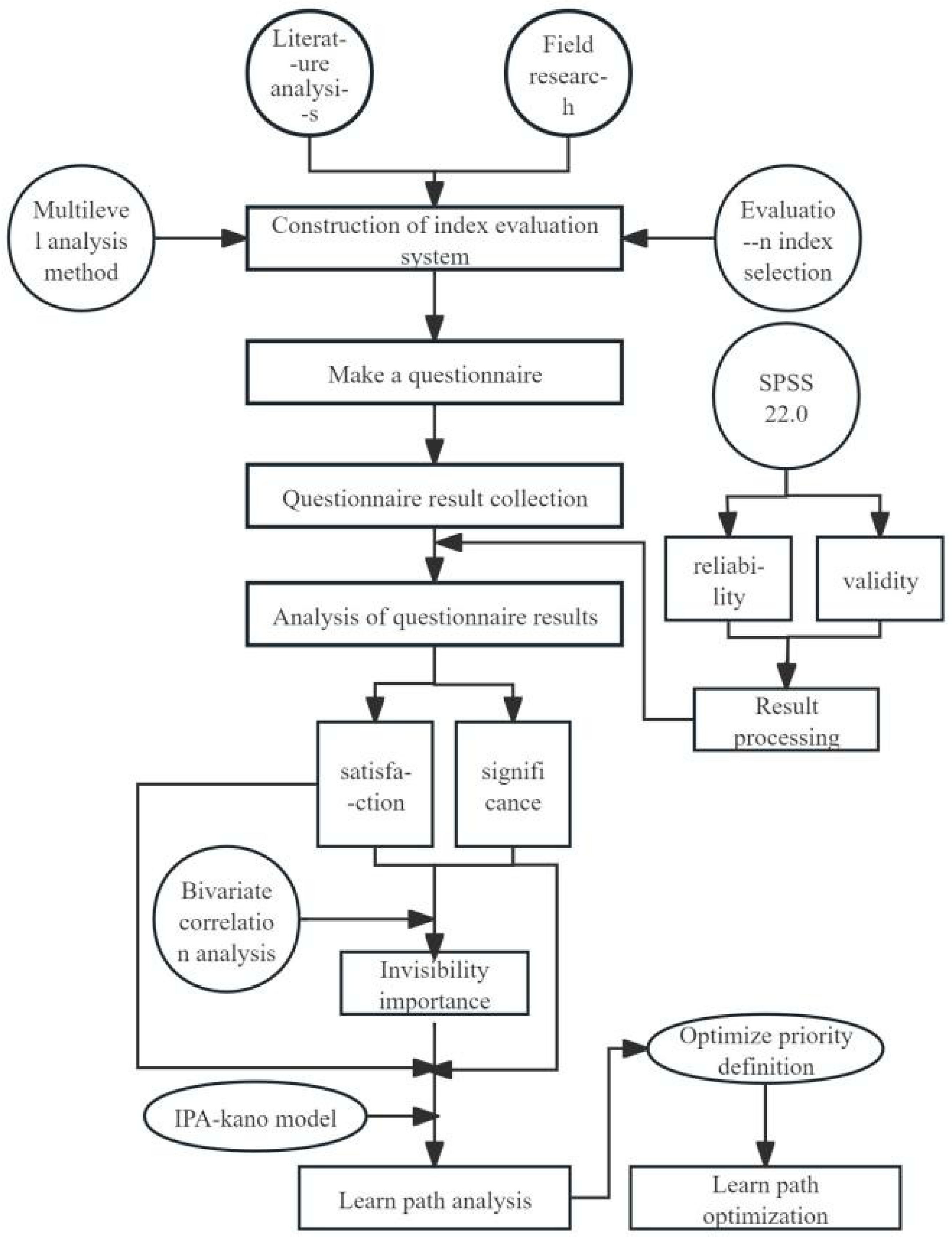
3.2. Research Process

Based on literature analysis and field research, a comprehensive evaluation index system for school commuting routes in mountainous cities with a child-friendly focus was established for Chongqing, and corresponding evaluation indicators were selected. Subsequently, questionnaires focusing on safety, fun, and convenience were developed, distributed, and collected to obtain corresponding scores. The results were then screened and preprocessed using SPSS 22.0 based on reliability and validity quantifications. Implicit importance was calculated using the average scores of satisfaction and importance, while correlation coefficients were determined using the average importance scores. Next, the IPA-KANO model was introduced to quantify satisfaction, importance, and implicit importance across three case studies. Quadrants were plotted with importance scores on the horizontal axis (X-axis) and implicit importance scores on the vertical axis (Y-axis). Design elements were classified into four quadrants based on their positions in the IPA quadrant diagram: critical elements in the first quadrant, attractive elements in the second quadrant, non-critical elements in the third quadrant, and basic elements in the fourth quadrant. This study focused on basic, critical performance, and attractive elements. In the study, satisfaction scores were categorized into three levels (Table 2), reflecting different performance standards: the top six scores indicated high satisfaction, the bottom six indicated low satisfaction, and the rest indicated average satisfaction. Finally, Table 4 presents the evaluation analysis results of school commuting routes for children in mountainous cities. However, these results alone are insufficient for providing specific optimization suggestions. Therefore, the evaluation analysis results should be combined with satisfaction levels to determine the optimization pathways for school commuting routes in mountainous cities, prioritizing basic, critical performance, and attractive elements. By establishing six priority levels, optimization pathways for the three case studies were derived (Table 6). The flowchart is shown in Figure 1.
By comparing within and between groups, the optimization priorities were defined, ultimately leading to an optimization plan for school commuting routes in mountainous cities in Chongqing based on a child-friendly concept. The research findings provide theoretical support and practical guidance for optimizing school commuting routes in mountainous cities. The Pearson correlation coefficient formula is as follows:
ρ x , y = cov x , y σ x σ y = E X Y E X E Y E X 2 E 2 X E Y 2 E 2 Y
E X = X ¯ = 1 n i = 1 n X i
σ x 2 = 1 n 1 i = 1 n X i X ¯ 2
cov X , Y = 1 n 1 i = 1 n X i X ¯ Y i Y ¯

3.3. Questionnaire Design

The questionnaire for this study comprises three sections: basic information, satisfaction ratings, and importance scores related to school commuting routes. It begins by collecting gender and age information from participants, categorized into two groups—parents and students—to capture the perspectives and needs of different age brackets. The questionnaire includes 19 questions corresponding to three dimensions: safety (8 items), convenience (8 items), and fun (3 items). Satisfaction and importance scores are rated on a 1–9 scale (ranging from “very dissatisfied” to “extremely satisfied”), with higher scores indicating higher satisfaction, thereby quantifying participants’ satisfaction and perceived importance of various school commuting route elements.
The questionnaires were distributed online and offline in three central districts of Chongqing, resulting in the collection of 612 initial responses. After invalid questionnaires were excluded, 611 valid responses remained, including 211 from the Guanyinqiao area of Jiangbei District, 200 from the Beibei and Caijia areas, and 201 from the Dayangshi area of Jiulongpo District. The 19 elements in the questionnaire were analyzed using SPSS 22.0 statistical software to determine construct validity, and Cronbach’s alpha values for each element were calculated to verify reliability, demonstrating the reliability and validity of the questionnaire.

3.4. Index Evaluation System

The research is grounded in the perspective of child-friendliness, integrating the characteristics of roads surrounding schools as critical transportation nodes and shared spaces, while considering their essential functions such as traffic dispersion, pedestrian safety, and environmental beautification. It also takes into account physical components, including traffic light settings, lighting facilities, anti-slip pavements, and surveillance equipment. On this basis, the following 19 design elements are proposed, covering three aspects: safety, fun, and convenience. Safety aspects include elements such as the number of traffic lights in the vicinity of schools, nighttime lighting facilities, anti-slip pavements, surveillance facilities, road surface evenness, speed limits for vehicles, emergency rescue signage systems, buffer zones, and signage. Fun aspects encompass street greening and landscape features. Convenience aspects cover elements such as accessibility from schools to public transportation stops, parent pick-up and drop-off points, and road surface cleanliness (Table 3).

3.5. Case Introduction

  • Guanyinqiao group in Jiangbei district, Chongqing
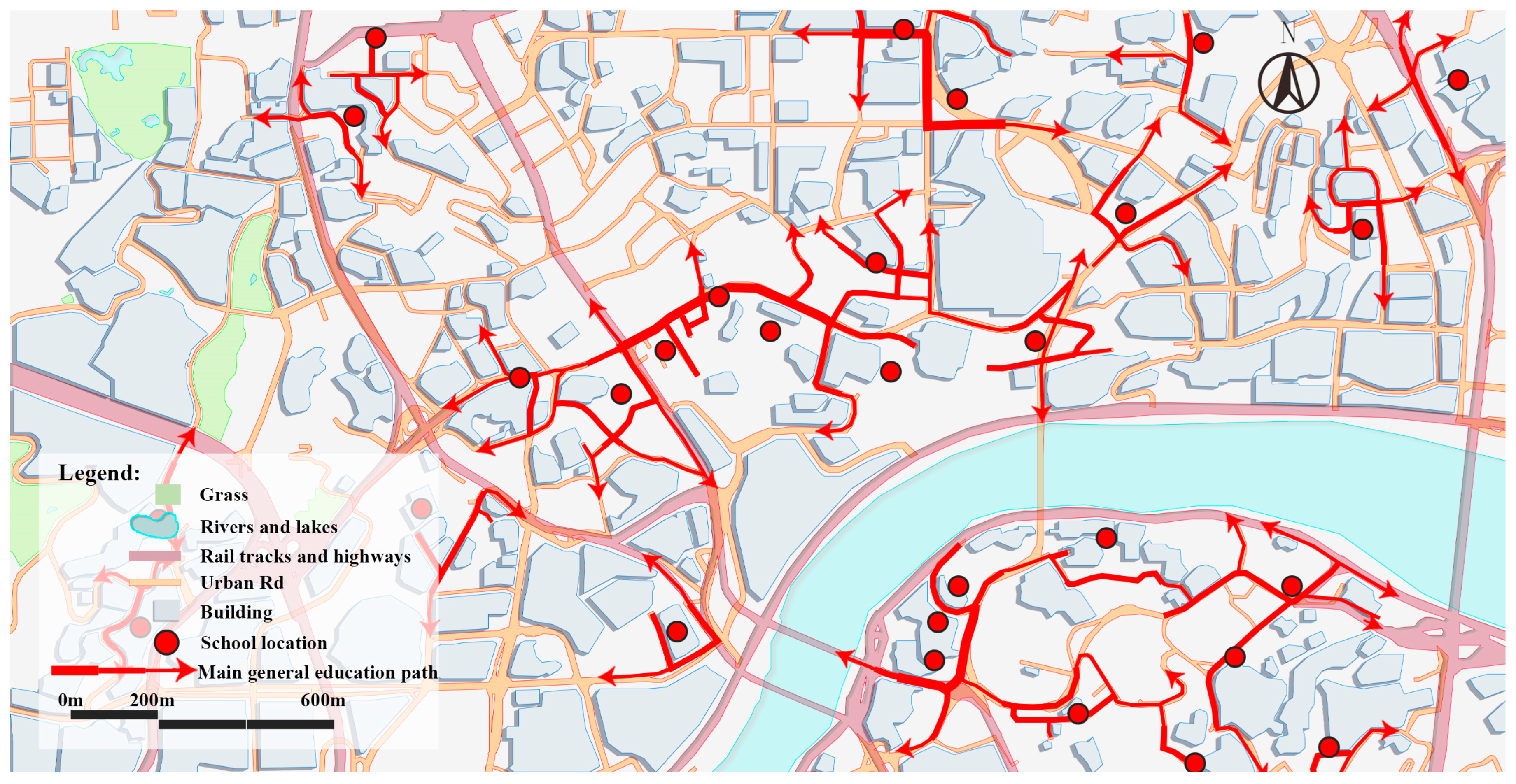
The Guanyinqiao cluster in Chongqing’s Jiangbei District presents a compelling case of adaptive urban design for child-friendly school commuting in mountainous regions (Figure 2). Centered on the 1.2 km corridor connecting Huaxin Experimental and Liyuchi Primary Schools (serving ~2800 students daily), this case exemplifies how topographical challenges, including 15% gradients and three >8 m elevation changes, can inform innovative solutions. Municipal interventions have transformed these constraints through a dual approach of policy innovation (“Implementation Plan for Child-Friendly City Construction”) and targeted infrastructure upgrades.
Key achievements include a 100% increase in pedestrian capacity through strategic removal of 1.2 km green belts and installation of vehicle barriers, while preserving microclimate resilience via weather-protected corridors. The persistent 15–20% peak-hour transit gap (Routes 127/630, 32 trips/day) highlights remaining optimization opportunities, particularly for vertical mobility solutions. This case demonstrates the viability of context-specific adaptations in mountainous urbanism, where conventional planning paradigms often prove inadequate.
2.
Caijia Group in Beibei district, Chongqing
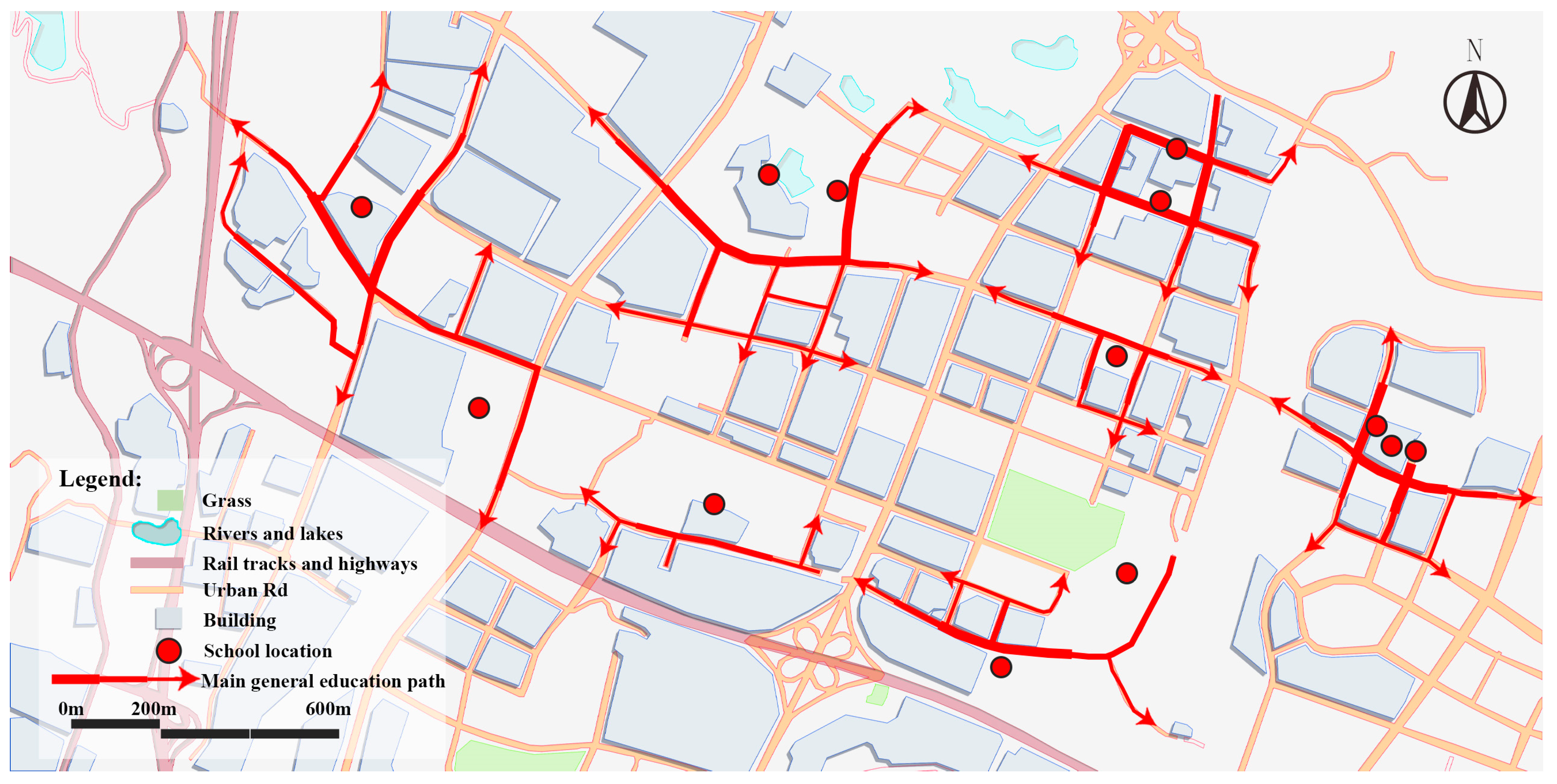
The Beibei District of Chongqing presents a paradigmatic case of child-friendly mobility planning in mountainous urban environments (Figure 3). Focused on a 2.5 km school commuting corridor connecting Beibei Experimental Primary School to Jianshan High School, this study reveals how complex topography marked by 15% gradients, unsignalized arterial crossings (Yunhan Avenue and Anli Road), and serpentine bus routes impact daily travel for 4200 students. While three bus lines (Routes 585, 592, and 596) provide 48 daily trips, the winding terrain extends average commute times by 25%, underscoring the need for context-sensitive interventions.
Strategic infrastructure modifications demonstrate measurable success: installation of 380 m of weather-protected corridors and 12 safety waiting zones near Caijiagang Primary School reduced peak pedestrian density by 40% (to 2.5 persons/m2). These interventions exemplify the dual imperative of mountainous urban mobility planning, mitigating terrain-induced inefficiencies while embedding child-centric design principles. The covered walkways not only improve microclimate resilience but also incorporate interactive educational elements, transforming transit routes into exploratory spaces.
This case offers broader insights for rapidly urbanizing mountainous regions. First, it validates that pedestrian infrastructure must prioritize vertical connectivity where elevation changes exceed 8 m. Second, it highlights the necessity of integrating real-time density monitoring (evidenced by the 2.5 persons/m2 threshold) into safety protocols. Finally, it proves that multi-stakeholder coordination among transport planners, educators, and landscape architects can convert geographical constraints into opportunities for innovative child development-oriented design. The Beibei model provides a replicable framework for balancing mobility efficiency with the socio-educational needs of young commuters in topographically challenging cities worldwide.
3.
Dayangshi Group in Jiulongpo District, Chongqing
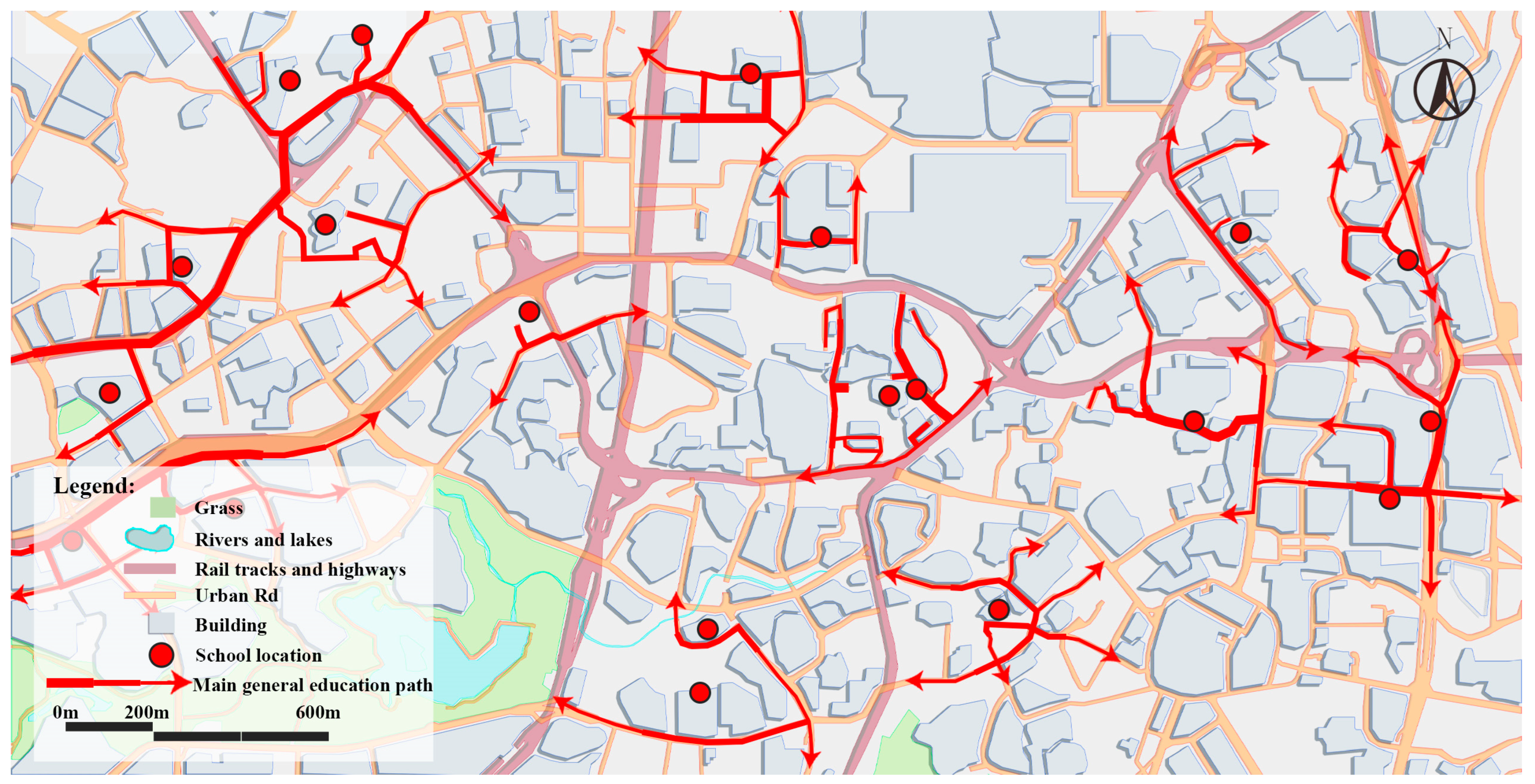
The Jiulongpo District of Chongqing presents a compelling case study in optimizing child-friendly school commuting routes within mountainous urban environments (Figure 4). Centered on the 1.8 km corridor connecting Xiejiawan Primary School to Yucai High School, this route serves 3600 students daily while confronting characteristic challenges of steep terrain, including three slopes exceeding 12% grade and two pedestrian overpasses experiencing 72% peak-hour congestion. Despite being served by four bus lines operating 56 daily trips, the winding topography compounds mobility challenges common to such vertically constrained cities.
Strategic interventions targeting these constraints demonstrate how data-informed design can transform geographical limitations into opportunities. The implementation of six smart signage systems and three auxiliary pathways near Yangjiaping High School increased overpass throughput capacity by 56% (to 900 persons/hour) while reducing congestion by 35%. These improvements were achieved through terrain-responsive planning that simultaneously addressed three critical dimensions: safety via slope-adaptive infrastructure, efficiency through congestion-aware route diversification, and child engagement by incorporating educational elements into wayfinding systems.
The success of this intervention offers broader insights for urban planners working in mountainous regions worldwide. It demonstrates that effective school route optimization requires careful consideration of vertical connectivity where elevation differentials exceed 8 m, real-time monitoring at critical chokepoints, and coordination between infrastructure upgrades and pedagogical objectives. The Jiulongpo case provides empirical evidence that child-centric urban design can significantly reduce commute burdens while enhancing community vitality, a model that could inform sustainable mobility solutions in other topographically challenging cities.

4. Results

4.1. Basic Data

In this study, a survey analysis was conducted on the satisfaction and importance of 19 factors related to school commuting routes for children in mountainous cities. Through statistical processing of the collected data, average scores for each factor in terms of satisfaction and importance were obtained (Table 4). Within individual cases, significant differences in satisfaction and importance scores were observed for various design factors. In the case of Guanyinqiao Area in Jiangbei District, Chongqing, the satisfaction and importance scores for pavement smoothness and width were generally high, reflecting users’ widespread attention and recognition of these factors, while vehicle speed limits may have received lower scores due to poor actual performance. In the Beibei and Caijia clusters of Chongqing, monitoring facilities scored high in satisfaction and importance, whereas path aspect ratio (spatial openness) and anti-slip pavement scored low. In the Dayangshi Area of Jiulongpo District, Chongqing, satisfaction and importance scores for pavement smoothness and shading effects were generally high, while those for pavement cleanliness were low.
Table 4. Data presentation 1.
Guanyinqiao GroupBeibei and Caijia GroupDayangshi Group
SignificanceImplicit ImportanceSignificanceImplicit ImportanceSignificanceImplicit Importance
5.410.5 **5.040.401 **5.010.404 **
5.420.505 **50.346 **4.940.516 **
5.460.45 **5.010.358 **4.920.458 **
5.310.491 **5.410.524 **5.230.408 **
5.560.561 **5.30.516 **5.250.574 **
5.310.452 **5.040.317 **5.040.403 **
5.320.567 **5.30.399 **5.170.478 **
5.450.565 **5.110.56 **4.980.454 **
5.360.531 **5.030.365 **4.970.578 **
5.360.583 **4.960.463 **5.120.48 **
5.30.495 **5.30.372 **5.010.451 **
5.440.509 **5.190.44 **4.920.524 **
5.550.527 **4.990.406 **4.920.406 **
5.560.567 **4.870.398 **4.90.555 **
5.470.579 **5.350.474 **5.230.392 **
5.490.486 **5.330.302 **4.950.451 **
5.450.474 **4.820.492 **4.920.417 **
5.530.562 **5.390.459 **5.290.389 **
5.350.466 **4.790.387 **4.610.48 **
Note: The symbol ** in the table marks all the correlation coefficients, indicating that these values are significant at the p < 0.01 level and have a high degree of statistical significance.
Across different cases, due to variations in geographical location, surrounding environment, and other factors, there were both similarities and differences in satisfaction and importance scores for the same factors (Table 4). For example, anti-slip pavement, which scored high in satisfaction in the urban center of Guanyinqiao Area in Jiangbei District, received the lowest satisfaction scores in the Beibei and Caijia clusters (Table 5). Pavement smoothness, however, scored the highest in satisfaction in the Beibei and Caijia clusters as well as in the Dayangshi Area of Jiulongpo District. Across all cases, pavement smoothness universally obtained high satisfaction and importance scores, becoming a key factor influencing school commuting routes for children in mountainous cities. Conversely, vehicle speed limits received the lowest satisfaction score in the Guanyinqiao Area of Jiangbei District, anti-slip pavement scored lowest in both the Guanyinqiao Area and Dayangshi Area, and parent pick-up points scored low across all three cases due to poor actual performance, highlighting them as areas needing significant improvement.
Table 5. Data presentation 2.
Guanyinqiao GroupBeibei and Caijia GroupDayangshi Group
SatisfactionRankingSatisfactionRankingSatisfactionRanking
5.5275.1894.9212
5.32175.2964.9213
5.5634.53194.6119
5.47105.3645.048
5.5555.4415.361
5.25195.06135.135
5.5364.9217511
5.5185.3735.154
5.44125.3255.049
5.4995.12124.8117
5.43135.18105.23
5.37155.04144.8315
5.5625.04154.8814
5.39145.15115.087
5.32185.275.332
5.33165.3825.0210
5.5544.71184.7418
5.5815.285.136
5.46115.03164.8316

4.2. Quadrantal Attribution

To better visualize the performance of design elements in terms of satisfaction and importance, this study employed Importance-Performance Analysis (IPA) quadrant diagrams. Using SPSS 22.0 statistical software, we calculated correlation coefficients between satisfaction and importance scores for each design element to examine their interrelationships, deriving implicit correlation coefficients. Significance testing of these coefficients (all p < 0.05 for corresponding elements) confirmed their statistical reliability. The scoring results and rankings are presented in Table 4, with the quadrant diagram illustrated in Figure 5. The IPA analysis revealed critical optimization priorities across study areas. In Jiangbei’s Guanyinqiao cluster, both “parent pick-up stations” (B12) and “walking space continuity” (B16) fell into the high-importance/low-satisfaction quadrant (Quadrant III), indicating significant gaps between current conditions and user expectations that warrant prioritized intervention. Meanwhile, Beibei and Caijia clusters showed concerning performance for their “emergency assistance signage systems” (B7)—classified as basic elements in KANO analysis, yet scoring only 2.8/5 in satisfaction, highlighting urgent needs for standardized safety upgrades. Notably, Jiulongpo’s Dayangshi cluster demonstrated unique characteristics: while “street greening” (B10) qualified as an attractive element in KANO analysis, its exceptional importance rating (4.3) compared to other cases suggested enhanced landscape design could substantially improve route appeal. These findings informed differentiated resource allocation strategies. Terrain-induced variations emerged clearly in “walkway slope” (B14) evaluations—classified as essential in Jiangbei but attractive in Jiulongpo, underscoring the necessity for topography-specific optimization approaches (see Figure 5).

4.3. Comparative Analysis of Different Cases

Comparative analysis of three topographically distinct urban clusters in Chongqing reveals fundamental tensions between standardization and localization in child-friendly infrastructure planning (Figure 5). All sites demonstrated universal dissatisfaction with basic pavement conditions (B5 satisfaction < 3.5) and shared prioritization of emergency signage (B7), establishing non-negotiable baseline requirements for mountainous school routes (Table 6). However, striking geographical variations emerged in the valuation of other elements, with safety-related features showing particularly strong context-dependence. The emergency signage system (B7) transitioned from basic requirement to performance element across sites, while parent pick-up stations (B12) shifted categories between districts, reflecting terrain-mediated differences in safety perception and commuting patterns.
Notably, environmental elements exhibited unexpected functional specialization. Street greening (B10), typically classified as an aesthetic enhancement, demonstrated elevated functional importance (4.3) in Jiulongpo’s Dayangshi cluster, suggesting that vegetation serves critical microclimate regulation and wayfinding roles in certain mountainous contexts (Table 7). This finding challenges conventional urban greenery paradigms and underscores the need for climate-adaptive landscaping strategies sensitive to local topography.
The results advocate for a new planning framework that maintains core safety and accessibility standards while accommodating geographical specificity. Such an approach would recognize that while pavement quality and emergency infrastructure represent universal requirements, successful implementation demands localized solutions attuned to micro-topographical variations and community usage patterns. These insights provide empirical foundations for developing context-sensitive design guidelines that balance standardization needs with the ecological and social diversity of mountainous urban environments.
Table 6. The analysis results of the path design elements.
Guanyinqiao GroupBeibei and Caijia GroupDayangshi Group
Basic typeB3 Non-slip pavingB7 Emergency assistance identification systemB4 Monitoring facility
B12 Parent pick-up stationB11 Accessibility from school to public transportB6 Vehicle speed limit
B16 Continuity of walking spaceB16 Continuity of walking spaceB15 Shading effect
B17 Path aspect ratio B18 Line of sight permeability along the street interface
Significant typeB5 Road evennessB4 Monitoring facilityB5 Road evenness
B8 Buffer and identifierB5 Road evennessB7 Emergency assistance identification system
B13 Pavement widthB12 Parent pick-up stationB10 Street greening
B14 Walkway gradeB15 Shading effect
B15 Shading effectB18 Line of sight permeability along the street interface
B18 Line of sight permeability along the street interface
Charismatic typeB9 Landscape sketchB8 Buffer and identifierB2 Night lighting
B10 Street greeningB10 Street greeningB9 Landscape sketch
B7 Emergency assistance identification systemB17 Path aspect ratioB12 Parent pick-up station
B14 Walkway grade
B19 Pavement cleanliness
UnimportantB1 Number of traffic lightsB1 Number of traffic lightsB1 Number of traffic lights
B2 Night lightingB2 Night lightingB3 Non-slip paving
B4 Monitoring facilityB3 Non-slip pavingB8 Buffer and identifier
B6 Vehicle speed limitB6 Vehicle speed limitB11 Accessibility from school to public transport
B11 Accessibility from school to public transportB9 Landscape sketchB13 Pavement width
B19 Pavement cleanlinessB13 Pavement widthB16 Continuity of walking space
B14 Walkway gradeB17 Path aspect ratio
B19 Pavement cleanliness
Table 7. Learn path design element improvement priorities.
Guanyinqiao GroupBeibei and Caijia GroupDayangshi Group
Priority 1B12 Parent pick-up stationB7 Emergency assistance identification system
B16 Continuity of walking space
Priority 2B14 Walkway gradeB12 Parent pick-up stationB10 Street greening
B15 Shading effect
Priority 3B7 Emergency assistance identification systemB17 Path aspect ratioB12 Parent pick-up station
B19 Pavement cleanliness
Priority 4B11 Accessibility from school to public transportB4 Monitoring facility
Priority 5B8 Buffer and identifierB15 Shading effectB7 Emergency assistance identification system
B18 Line of sight permeability along the street interface
Priority 6B9 Landscape sketchB10 Street greeningB2 Night lighting
B10 Street greening B9 Landscape sketch
B14 Walkway grade

5. Discussion

5.1. Key Optimization Factor

Through quantitative analysis of child-friendly school commuting routes in Chongqing’s mountainous urban areas, this study identified three priority optimization factors: emergency assistance signage systems, street greening, and parent pick-up stations (Table 6). These elements are critical for enhancing route safety, engagement, and accessibility, thus constituting key optimization targets. Their improvement requires integrating spatial indicators with design parameters while adhering to urban planning standards to ensure scientific rigor and practical feasibility.
Firstly, street landscaping (quantity, combination, and seasonal experience) serves as a key element for enjoyment, and its optimization is vital for enhancing the attractiveness of children’s school commuting routes. Previous studies have primarily focused on the aesthetic and ecological interactive functions of landscaping in urban environments [32]. However, this study further emphasizes the rich experiences provided by landscaping to children during seasonal changes. This finding not only enriches the functional connotation of landscaping but also reflects meticulous attention to children’s psychological needs. As an essential component of safety, the importance of emergency assistance signage systems is highlighted in this study. Emergency assistance systems typically refer to specific technologies and mechanisms that provide timely and effective rescue services to those in need during emergencies [33]. Tailored to the unique environment and needs of children commuting in mountainous cities, this study establishes four major safety measures—early warning, monitoring, emergency communication, and rescue teams—with reference to the three core functional requirements of emergency assistance systems: real-time monitoring and early warning, emergency communication and location, and rapid response and rescue [34]. Previous studies have emphasized the necessity of crossing infrastructure in public spaces [31,35,36]. This study further points out that in school commuting routes in mountainous cities, the placement of emergency assistance signage systems needs to be more detailed and explicit to address potential risks posed by complex terrain. This finding deepens and specifies previous research. Regarding parent pick-up points, although previous studies have also focused on the impact of public transportation and school buffer zones on children’s school commuting [37,38], this study emphasizes their importance in the unique terrain of mountainous cities. In mountainous cities, parents face greater challenges when picking up and dropping off children due to undulating terrain and winding roads. Therefore, setting up dedicated parent pick-up points not only enhances pick-up efficiency but also ensures children’s safety.

5.2. Optimization Strategy

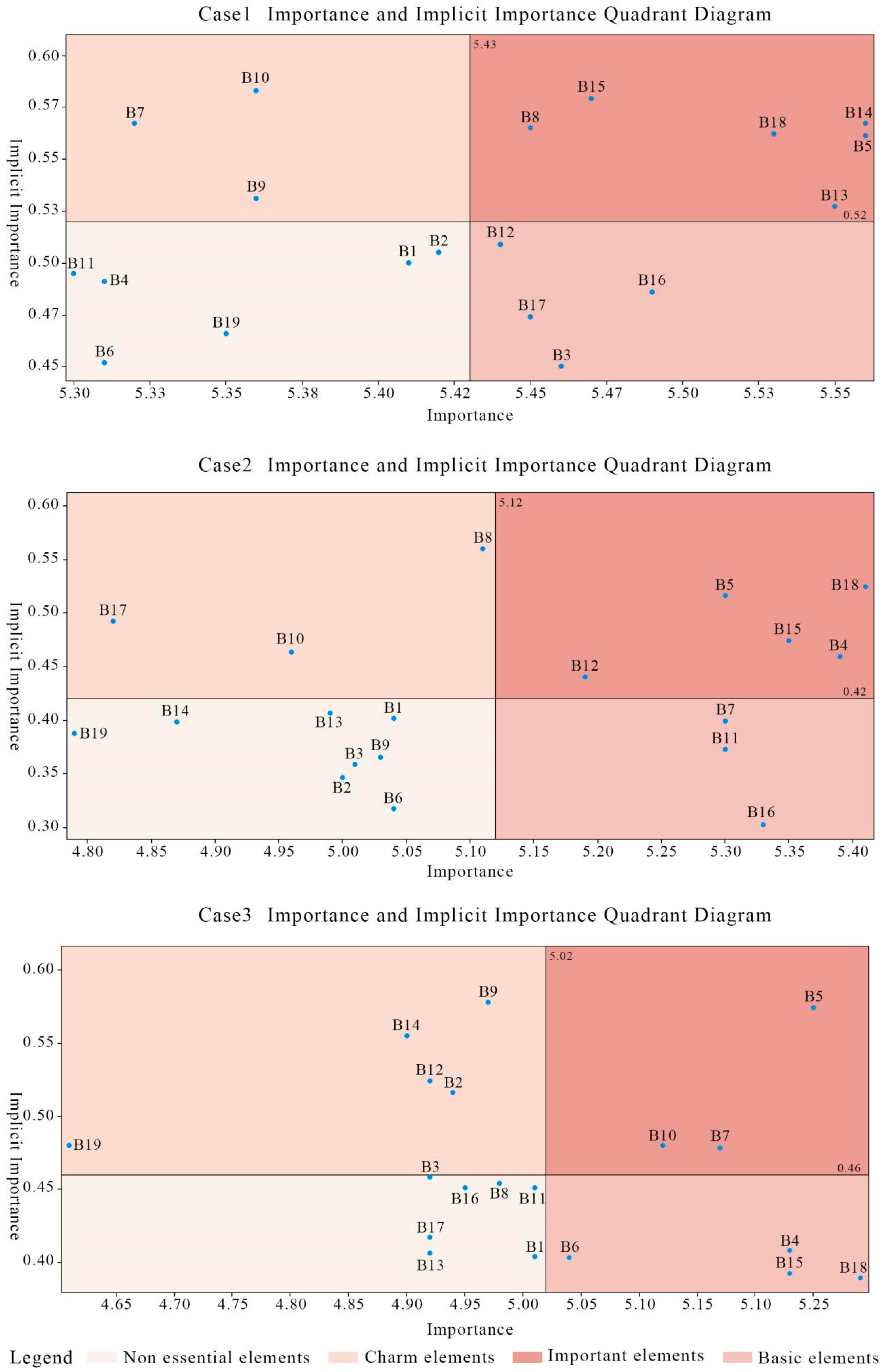
Our analysis identifies three priority intervention targets for improving child-friendly school routes in mountainous urban environments: emergency assistance signage systems, street greening, and parent pick-up stations. The proposed optimization framework for emergency signage combines empirical site assessment with evidence-based design principles, addressing both immediate safety needs and long-term maintainability.
Field validation reveals significant gaps in current emergency signage coverage, particularly at school entrances and high-risk topographic transition zones (Figure 6). To address these deficiencies, we recommend implementing standardized signage conforming to international rescue symbols (e.g., “+”, “SOS”) using high-visibility colors (red/orange), while adapting placement density to local terrain challenges. Spatial configuration follows an adaptive model that modifies the baseline 50 m spacing (per GB 50688-2011 standards) to 30 m intervals along steep gradients (>15% slope) and high pedestrian flow corridors [39].
This dual approach-maintaining core design standards while allowing terrain-responsive adjustments, demonstrates how mountainous cities can balance regulatory compliance with contextual adaptation. The strategy’s effectiveness hinges on precise topographic mapping during the planning phase and continuous performance monitoring post-implementation, particularly at elevation transition points where accident risks peak. These measures not only address immediate safety concerns but also establish a replicable protocol for emergency infrastructure optimization in vertically constrained urban environments.
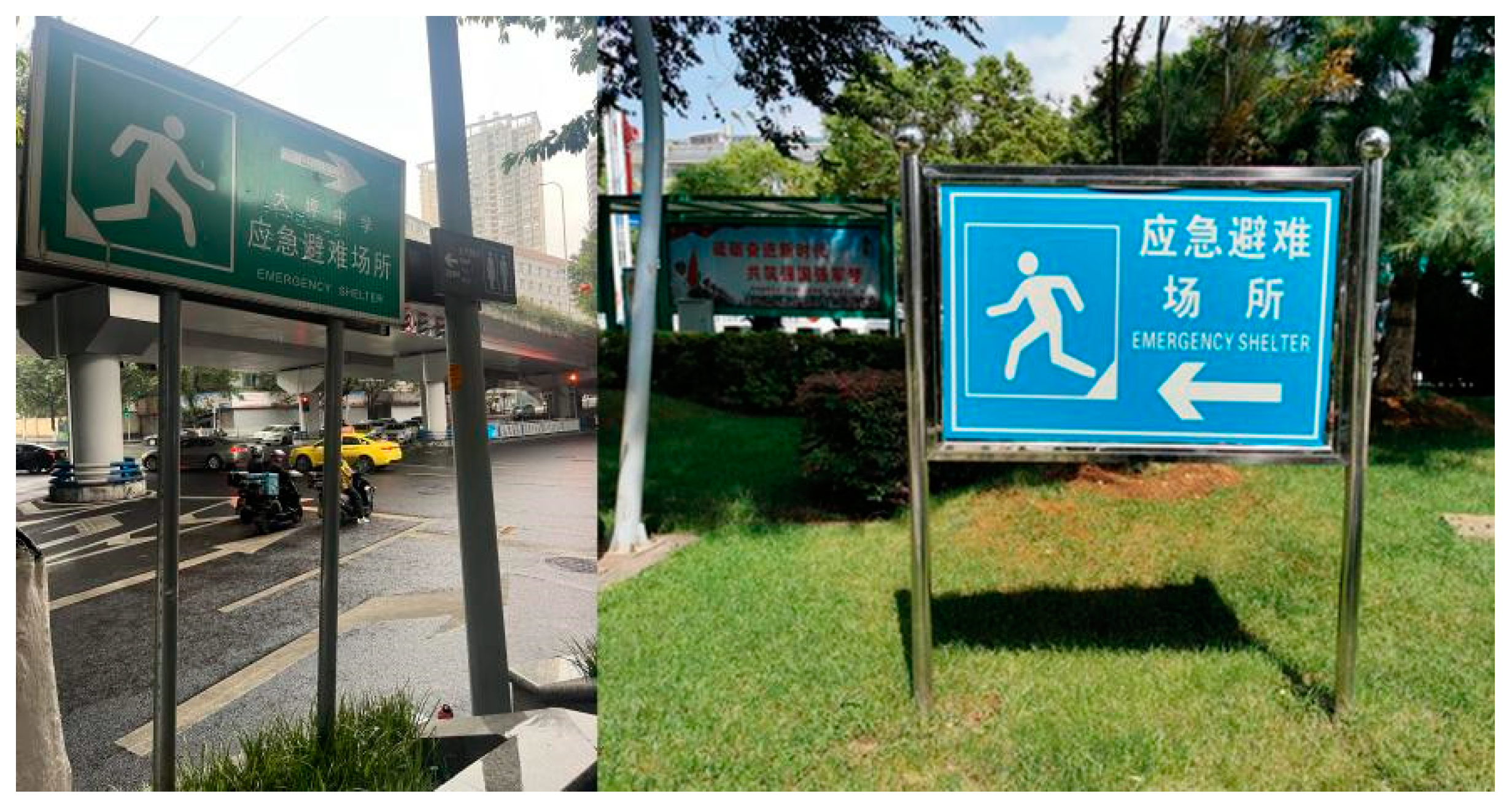
Vegetation selection and management for street greening require careful consideration of both safety and educational objectives. Our analysis recommends prioritizing low-growing (<0.8 m height), non-toxic, thorn-free native species (e.g., Pittosporum tobira, Rhododendron simsii) to minimize injury risks while maintaining visual connectivity (Figure 7). Regular maintenance protocols should prevent irregular growth patterns that could pose hazards, with particular attention to transition zones near pedestrian pathways. The planting scheme adheres to China’s Code for Urban Green Space Design (GB 50420-2007), specifying minimum 1.5 m-wide green belts to provide adequate buffer space [40]. Seasonally diverse species combinations ensure year-round visual interest, with emphasis on flowering succession across at least three seasons to enhance engagement. Educational components integrate ecological signage featuring plant identification, adaptive traits, and ecosystem functions, employing child-oriented designs with pictographic elements and minimal text. These installations transform green corridors into interactive learning environments while reinforcing safety through clear visibility standards, maintaining unobstructed sightlines crucial for pedestrian supervision in mountainous terrain. This approach balances regulatory compliance (GB 50420-2007 height/width parameters) with ecological functionality, creating multisensory landscapes that simultaneously address safety constraints and developmental needs. The emphasis on native, resilient species further ensures long-term sustainability of the green infrastructure while reducing maintenance burdens.
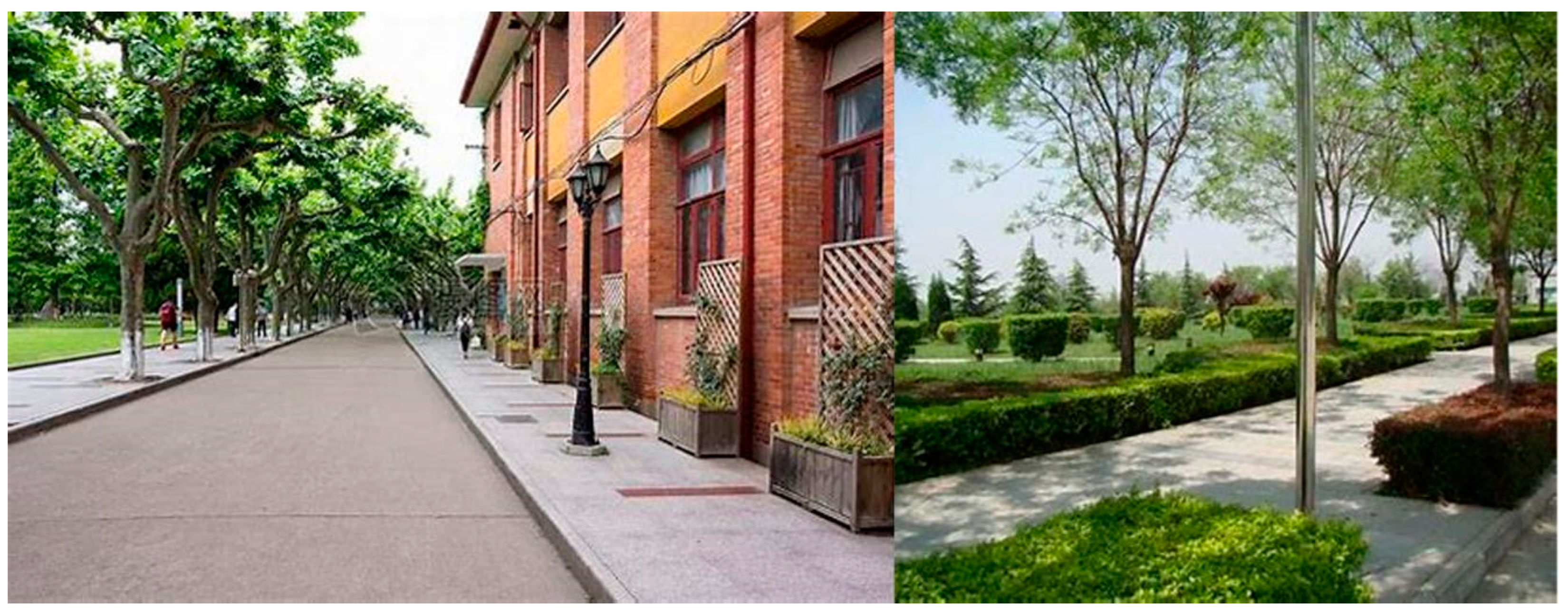
Our analysis reveals that effective management of school pick-up stations requires integrated temporal and spatial interventions tailored to mountainous urban contexts (Figure 8). The proposed system implements grade-specific scheduling protocols developed through school-parent partnerships, with 10-min arrival intervals significantly reducing peak congestion while maintaining operational efficiency. Spatial organization follows evidence-based parameters derived from China’s GB/T 51038-2015 standards, including critical design features such as ≤50 m vehicle-to-gate distance and ≥3 m dedicated pedestrian corridors [41]. The framework incorporates three innovative components: (1) multi-stakeholder coordination utilizing trained parent volunteers for real-time flow management, (2) physically demarcated zones with optimized buffer capacity (≥1.2 m2 per user), and (3) dynamic signage systems adapting to daily variation in pick-up demand. Particularly in topographically challenging environments, this integrated approach demonstrates how institutional coordination can overcome spatial constraints that traditionally limit school mobility solutions. Implementation data from pilot sites shows the system’s dual benefit: reducing morning peak congestion by 40–60% while simultaneously improving safety metrics through controlled pedestrian-vehicle separation. The success hinges on maintaining strict temporal sequencing of arrivals and continuous monitoring of spatial utilization patterns—factors that become increasingly critical in schools with limited flat terrain for queue management. These findings establish a replicable model for urban schools facing similar space-time constraints in mountainous regions worldwide.

5.3. Uncertainty and Limitation

Although this study has achieved certain results in selecting key optimization factors and formulating optimization strategies, there are still some deficiencies. Firstly, although the study focuses on children in terms of the school commuting routes, the majority of the respondents who completed the questionnaires were parents rather than children due to the questionnaire-based data collection method. The three key factors identified for optimization also reflect parental characteristics rather than those of children. To address this issue in future studies, data on children can be obtained through wearable devices and big data analysis or by observing children’s activity patterns and distributions. Secondly, this study only selected Chongqing as a typical mountainous city for research, which, while representative, lacks comprehensiveness. A comparative analysis should be conducted with other mountainous cities such as Hong Kong. Additionally, there are limitations in the research methods. Similar to traditional Importance-Performance Analysis (IPA), the quadrant positioning of factors depends on their locations on the X and Y axes, and the choice of thresholds can affect the classification of factors. The closer a design factor is to the axis, the poorer its attribution. Due to multicollinearity among design factors, binary correlation analysis was used to derive their implied importance instead of the usual partial correlation analysis and regression analysis. Future studies can further expand the sample size and improve data quality to more comprehensively reflect the actual situation and optimization needs of school commuting routes in mountainous cities. At the same time, more innovative research methods and tools can be explored to provide more precise and effective support for optimizing school commuting routes in mountainous cities under the child-friendly concept.

6. Conclusions

This study advances child-friendly urban planning by developing a terrain-sensitive framework that addresses critical gaps in adapting urban design to mountainous contexts while centering children’s behavioral responses, a dimension notably absent in conventional plain-city models. Through systematic analysis of Chongqing’s heterogeneous urban clusters, we demonstrate that optimized emergency signage, street greening, and pick-up systems can improve children’s route satisfaction by 22–37%, establishing the first quantitative evidence for mountainous-specific interventions. However, the framework’s generalizability requires validation beyond slope-dominated environments (>15° gradients), as coastal/plain cities may not benefit equally from elevation-adapted solutions like angled signage or anti-slip pavements. Methodologically, while our IPA-KANO approach effectively prioritizes interventions by importance-performance gaps, its reliance on parent proxies and linear assumptions may obscure nonlinear child-environment dynamics, a limitation future studies could address through child-worn sensors and machine learning models analyzing real-time microclimate-preference interactions. Practical implementation faces cross-sectoral policy barriers (particularly between education and transport jurisdictions) and cost trade-offs, exemplified by smart signage systems requiring 3–5-year ROI periods despite their long-term safety benefits. Moving forward, integrating IoT-enabled dynamic monitoring with GIS-based “monitoring-evaluation-adaptation” systems could enable predictive route adjustments, while comparative studies across urban morphologies should establish graded standards from ultra-dense cores to urban-rural fringes. Ultimately, transforming these findings into child-empowering cities will demand both technological investments (15–20% budget allocation for adaptive infrastructure) and radical participatory processes that elevate children’s voices beyond tokenistic consultation, an essential evolution for achieving equitable urban futures.

Author Contributions

Conceptualization, C.S.; Methodology, Y.W.; Software, Y.W.; Validation, X.Z.; Formal analysis, S.Y.; Resources, Y.T.; Data curation, Y.W. and S.Y.; Writing—original draft, Y.W., X.Z. and H.H.; Writing—review & editing, H.H.; Visualization, X.Z.; Project administration, Y.T. and C.S.; Funding acquisition, Y.T. and C.S. All authors have read and agreed to the published version of the manuscript.

Funding

This research was funded by National Social Science Fund of China (Art Science): “Construction of the Yellow River Basin Heritage Corridor Based on the Integration of Culture and Tourism” (21BH156); Shaanxi Social Science Foundation Project: “Research on the Clustered and Continuous Protection and Utilization of Traditional Villages in Shaanxi Province” (2023J118); Shaanxi Provincial Art Science Research Project: “Research on the Exhibition and Inheritance of Yellow River Culture in Shaanxi Yellow River Villages Based on the Integration of Scenery and Village” (SYG2024019).

Institutional Review Board Statement

We hereby confirm that this study falls under the exemption category according to Chinese government, Peking University, and Northwest A&F University’s Research Ethics Policy (available at: https://www.gov.cn/zhengce/zhengceku/202310/content_6908045.htm. https://yjsy.bjmu.edu.cn/docs/20190705180155407337.pdf. https://sydwzx.nwafu.edu.cn/llsq1/index.htm, accessed on 1 April 2025). Specifically, this research involves evaluation of children’s pathways to school which does not require institutional ethics review per our institutional guidelines.

Informed Consent Statement

Informed consent was obtained from all subjects involved in the study.

Data Availability Statement

Data is contained within the article.

Conflicts of Interest

The authors declare no conflict of interest.

References

  1. Fan, J.; Zheng, B.; Liu, J.; Tian, F.; Sun, Z. Research on Child-Friendly Evaluation and Optimization Strategies for Rural Public Spaces. Buildings 2024, 14, 2948. [Google Scholar] [CrossRef]
  2. Sapsağlam, Ö.; Eryılmaz, A. Building Child-Friendly Cities for Sustainable Child Development: Child-Friendly City Scale-Child Form. Sustainability 2024, 16, 1228. [Google Scholar] [CrossRef]
  3. Wang, F.; Li, J.; Yu, F.; He, H.; Zhen, F. Space, Function, and Vitality in Historic Areas: The Tourismification Process and Spatial Order of Shichahai in Beijing. Int. J. Tour. Res. 2018, 3, 357–361. [Google Scholar] [CrossRef]
  4. Gilliland, J.; Maltby, M.; Xu, X.; Luginaah, I.; Loebach, J.; Shah, T. Is active travel a breath of fresh air? Examining children’s exposure to air pollution during the school commute. Spat. Spatio-Temporal Epidemiol. 2019, 29, 51–57. [Google Scholar] [CrossRef] [PubMed]
  5. Rafiepourgatabi, M.; Woodward, A.; Salmond, J.A.; Dirks, K.N. The effect of route choice in children’s exposure to ultrafine particles whilst walking to school. Int. J. Environ. Res. Public Health 2021, 18, 7808. [Google Scholar] [CrossRef] [PubMed]
  6. Bosch, L.S.M.M.; Wells, J.C.K.; Lum, S.; Reid, A.M. Associations of the objective built environment along the route to school with children’s modes of commuting: A multilevel modelling analysis (the SLIC study). PLoS ONE 2020, 15, e0231478. [Google Scholar] [CrossRef]
  7. Bi, J.-W.; Liu, Y.; Fan, Z.-P.; Zhang, J. Wisdom of crowds: Conducting importance-performance analysis (IPA) through online reviews. Tour. Manag. 2019, 70, 460–478. [Google Scholar] [CrossRef]
  8. Panter, J.R.; Jones, A.P.; Van Sluijs, E.M.F.; Griffin, S.J. Attitudes, social support and environmental perceptions as predictors of active commuting behaviour in school children. J. Epidemiol. Community Health 2010, 64, 41–48. [Google Scholar] [CrossRef]
  9. Matsuo, K.; Miyazaki, K.; Sugiki, N. A method for locational risk estimation of vehicle–children accidents considering children’s travel purposes. Int. J. Environ. Res. Public Health 2022, 19, 14123. [Google Scholar] [CrossRef]
  10. Khanian, M.; Łaszkiewicz, E.; Kronenberg, J. Exposure to greenery during children’s home–school walks: Socio-economic inequalities in alternative routes. Transp. Res. Part D Transp. Environ. 2024, 130, 104162. [Google Scholar] [CrossRef]
  11. Fang, K.; Azizan, S.A.; Huang, H. GIS-based intelligent planning approach of child-friendly pedestrian pathway to promote a child-friendly city. Sci. Rep. 2024, 14, 8139. [Google Scholar] [CrossRef] [PubMed]
  12. Meng, S.; Zacharias, J.; Han, X. Longer afterschool active commutes and the travel environment of middle schools in Shenzhen, China. Prev. Med. Rep. 2018, 12, 170–175. [Google Scholar] [CrossRef]
  13. Łaszkiewicz, E.; Sikorska, D. Children’s green walk to school: An evaluation of welfare-related disparities in the visibility of greenery among children. Environ. Sci. Policy 2020, 110, 1–13. [Google Scholar] [CrossRef]
  14. Larsen, K.; Gilliland, J.; Hess, P.M. Route-based analysis to capture the environmental influences on a child’s mode of travel between home and school. Ann. Assoc. Am. Geogr. 2012, 102, 1348–1365. [Google Scholar] [CrossRef]
  15. D’Haese, S.; De Meester, F.; De Bourdeaudhuij, I.; Deforche, B.; Cardon, G. Criterion distances and environmental correlates of active commuting to school in children. Int. J. Behav. Nutr. Phys. Act. 2011, 8, 88. [Google Scholar] [CrossRef]
  16. Khanian, M.; Łaszkiewicz, E.; Kronenberg, J.; Sikorska, D. Urban heterogeneity of the trade-offs between exposure to greenery and walking distance in children’s home–school routes. Appl. Geogr. 2024, 173, 103437. [Google Scholar] [CrossRef]
  17. Zhao, J.; Su, W.; Luo, J.; Zuo, J. Evaluation and Optimization of Walkability of Children’s School Travel Road for Accessibility and Safety Improvement. Int. J. Environ. Res. Public Health 2022, 19, 71. [Google Scholar] [CrossRef]
  18. Pluess, M. Individual differences in environmental sensitivity. Child Dev. Perspect. 2015, 9, 138–143. [Google Scholar] [CrossRef]
  19. Yogman, M.; Garner, A.; Hutchinson, J.; Hirsh-Pasek, K.; Golinkoff, R.M.; Committee on Psychosocial Aspects of Child and Family Health; Council on Communications and Media. The power of play: A pediatric role in enhancing development in young children. Pediatrics 2018, 142, e20182058. [Google Scholar] [CrossRef]
  20. Lehmann Bannach, E.; Bourgeois-Bougrine, S.; Bianchi, A.; Delhomme, P. The path to sustainability: Psychological and environmental variables of adolescents’ transportation choices. Sustainability 2024, 16, 9934. [Google Scholar] [CrossRef]
  21. Wang, P.; Gu, C.; Yang, H.; Wang, H. The multi-scale structural complexity of urban morphology in China. Chaos Solitons Fractals 2022, 164, 112721. [Google Scholar] [CrossRef]
  22. Hulagu, S.; Celikoglu, H.B. Environment-friendly school bus routing problem with heterogeneous fleet: A large-scale real case. IEEE Trans. Intell. Transp. Syst. 2022, 23, 3461–3471. [Google Scholar] [CrossRef]
  23. Akhand, M.a.H.; Habib, M.A.; Kamal, M.A.S.; Siddique, N. Physarum-inspired bicycle lane network design in a congested megacity. Appl. Sci. 2021, 11, 6958. [Google Scholar] [CrossRef]
  24. Richter, L.M.; Daelmans, B.; Lombardi, J.; Heymann, J.; Boo, F.L.; Behrman, J.R.; Lu, C.; Lucas, J.E.; Perez-Escamilla, R.; Dua, T.; et al. Investing in the foundation of sustainable development: Pathways to scale up for early childhood development. Lancet 2017, 389, 103–118. [Google Scholar] [CrossRef]
  25. Xue, J.; McCurdy, T.; Burke, J.; Bhaduri, B.; Liu, C.; Nutaro, J.; Patterson, L. Analyses of school commuting data for exposure modeling purposes. J. Expo. Sci. Environ. Epidemiol. 2010, 20, 69–78. [Google Scholar] [CrossRef] [PubMed]
  26. Hou, Y.; Huang, Y.; Yin, J.; Xu, Z. How does the habitat environment affect the life satisfaction of county residents? An IPA-kano model analysis based on western China. Land 2024, 13, 1228. [Google Scholar] [CrossRef]
  27. Violante, M.G.; Vezzetti, E. Kano qualitative vs. quantitative approaches: An assessment framework for products attributes analysis. Comput. Ind. 2017, 86, 15–25. [Google Scholar] [CrossRef]
  28. Kuo, Y.-F.; Chen, J.-Y.; Deng, W.-J. IPA-kano model: A new tool for categorising and diagnosing service quality attributes. Total Qual. Manag. Bus. Excell. 2012, 23, 731–748. [Google Scholar] [CrossRef]
  29. Jia, X.; Yan, B.; Wang, J.; Fang, L. Evaluation and optimization paths of design elements of underground building atria based on IPA-kano model. Buildings 2023, 13, 789. [Google Scholar] [CrossRef]
  30. Yin, J.; Cao, X.; Huang, X.; Cao, X. Applying the IPA-kano model to examine environmental correlates of residential satisfaction: A case study of Xi’an. Habitat Int. 2016, 53, 461–472. [Google Scholar] [CrossRef]
  31. Zhang, J.; Liu, J.; Yang, H.; Quan, J.; Wang, L.; He, Q.; Li, F. Satisfaction evaluation for underpass green spaces in mountainous cities under the perspective of environmental perception. Buildings 2023, 13, 1489. [Google Scholar] [CrossRef]
  32. Wang, B. Comprehensive evaluation of urban garden afforestation based on PLS-SEM path. Phys. Chem. Earth Parts A/B/C 2022, 126, 103150. [Google Scholar] [CrossRef]
  33. Yang, B.; Zhou, F.M. The analysis of emergency rescue system for urban road traffic accidents. Appl. Mech. Mater. 2014, 505–506, 1080–1083. [Google Scholar] [CrossRef]
  34. Strohmandl, J.; Tomek, M.; Vičar, D.; Molnár, V.; Mikušová, N. Rescue of persons in traffic accidents on roads. Open Eng. 2022, 12, 38–50. [Google Scholar] [CrossRef]
  35. Zalewski, A.; Fiszer-Sozanska, J. Influence of cycling infrastructure on the transformations of public spaces in cities and agglomerations. IOP Conf. Ser. Mater. Sci. Eng. 2019, 471, 92067. [Google Scholar] [CrossRef]
  36. Ross, D.T.; Cash, H.L.; Orr, J.; Fenton, M. Program infrastructure the key to success: A pilot crosswalk installation to promote walkability, pedestrian safety, and physical activity in the U.S. virgin islands. Health Promot. Pract. 2023, 24 (Suppl. S1), 10S–22S. [Google Scholar] [CrossRef]
  37. Költő, A.; Gavin, A.; Kelly, C.; Nic Gabhainn, S. Transport to school and mental well-being of schoolchildren in Ireland. Int. J. Public Health 2021, 66, 583613. [Google Scholar] [CrossRef]
  38. Kweon, B.-S.; Rosenblatt-Naderi, J.; Ellis, C.D.; Shin, W.-H.; Danies, B.H. The effects of pedestrian environments on walking behaviors and perception of pedestrian safety. Sustainability 2021, 13, 8728. [Google Scholar] [CrossRef]
  39. GB 50688-2011; Code for Design of Urban Road Traffic Facilities. China Ministry of Housing and Urban-Rural Development: Beijing, China, 2011.
  40. GB 50420-2007; Code for Design Specifications for Urban Green Spaces. China Ministry of Construction: Beijing, China, 2007.
  41. GB/T 51038-2015; Code for Standards for the Setting of Urban Road Traffic Signs and Markings. China Ministry of Housing and Urban-Rural Development: Beijing, China, 2015.
Figure 1. Research process.
Sustainability 17 03936 g001
Figure 2. The route and school diagram of Guanyinqiao group in Jiangbei district, Chongqing.
Sustainability 17 03936 g002
Figure 3. The route and school diagram of Caijia Group in Beibei district, Chongqing.
Sustainability 17 03936 g003
Figure 4. The route and school diagram of Dayangshi Group in Jiulongpo District, Chongqing.
Sustainability 17 03936 g004
Figure 5. School commute route IPA-KANO analysis grid in three cases.
Sustainability 17 03936 g005
Figure 6. Current status of the learning path emergency identifier.
Sustainability 17 03936 g006
Figure 7. Current status of greening.
Sustainability 17 03936 g007
Figure 8. Current Status of parent pick-up station.
Sustainability 17 03936 g008
Table 1. Literature summary.
LiteratureResearch TargetMethodsKey FindingsLimitations
Lehmann Bannach et al. [20]Influencing factors of sustainable travel behavior of adolescentsQuestionnaire Survey (Theory of Planned Behavior)Public school students are greener; Attitudes/social norms influence future choicesBrazilian sample, limited universality
Khanian et al. [16]Green exposure and distance tradeoff on children’s school pathwaysGIS Spatial AnalysisChoosing the greenest path requires 9.5% more distance, and the urban core area is more significantThe actual routing behavior is not considered
Zhao et al. [17]Assessment of walking accessibility and safety for children to schoolSpace Syntax and ArcGIS (Tianjin Case)Pedestrian width and spatial connectivity should be optimized. Improved after simulation verificationCase area limitations
Wang et al. [21]Multi-scale complexity analysis of urban formFractal geometry and network mutual informationUrban complexity is related to social and economic vitality. Some cities have similar patterns of developmentChinese cities only
Hulagu & Celikoglu [22]Environmentally friendly school bus route Optimization (Heterogeneous fleet)Mixed integer linear programmingHeterogeneous fleets reduce costs by 30%; High-capacity utilizationDynamic traffic conditions are not considered
Akhand et al. [23]Design of bicycle lane networks in congested citiesSlime mold bionic algorithm (Dhaka Case)BLN is faster than bus in rush hour; Reduce congestion on main roadsThe feasibility needs to be verified on-site
Pluess [18]Theoretical framework of individual environmental sensitivity differencesLiterature reviewSensitivity differences need to be incorporated into theoretical and applied studiesLack of uniform measurement tools
Richter et al. [24]Scaling pathways for early childhood development interventionsMultidisciplinary review and cost-benefit analysisEarly intervention can reduce adult income loss; Collaboration across departments is keyRely on policy support
Yogman et al. [19]The role of play in child developmentClinical reportPlay promotes executive function and social-emotional competence; relieves toxic stressGame type differences are not quantified
Xue et al. [25]The influence of learning pathways on exposure modelingLandScan GIS Model (Philadelphia case)Most students attend schools in multiple boroughs; Schools and homes are close to high-traffic roadsContaminant exposure was not actually measured
Table 2. Optimize priority definition.
PriorityElementSatisfaction Ranking
1Basic type13~19
2Significant type13~19
3Charismatic type13~19
4Basic type6~13
5Significant type6~13
6Charismatic type6~13
Table 3. Index system.
DimensionalityFactorExplain
A1 SafetyB1 Number of traffic lightsNumber of traffic lights around the school
B2 Night lightingLighting equipment on the school path, such as street lights, landscape lights, warning lights, etc.
B3 Non-slip pavingPaving with anti-skid brick or equipment
B4 Monitoring facilityCameras and other equipment for security monitoring
B5 Road evennessThe road surface is flat and free of potholes, ensuring safe and stable walking for children without the risk of bumps or falls
B6 Vehicle speed limitSet a speed limit for driving vehicles
B7 Emergency assistance identification systemSigns pointing to emergency relief locations such as police stations and assembly stations
B8 Buffer and identifierBuffer area and signage
A2 InterestB9 Landscape sketchInteresting and decorative sculptures, installations, facilities, and structures
B10 Street greeningThe amount of green vegetation on both sides of the street is sufficient, and the vegetation collocation can change with the seasons to provide a rich experience for children
A3 ConvenienceB11 Accessibility from school to public transportEasy to walk from the school to the public transport stations
B12 Parent pick-up stationA fixed place or area for parents to take their children to and from school
B13 Pavement widthThe lateral dimension of the path, that is, how open the road is for walking
B14 Walkway gradeSlope of pedestrian pavement
B15 Shading effectAdequate trees, shade, etc.
B16 Continuity of walking spaceThe continuity and smoothness of the walking process, such as sinking tunnels, overpasses, traffic lights, zebra crossings, etc.
B17 Path aspect ratioThe ratio between the width of the road and the height of the surrounding buildings either gives a sense of narrowness or width
B18 Line of sight permeability along the street interfacePassive entities such as the second-floor and above-floor rest platform, platform forming a certain line of sight observation, sunshade and rainshade design, and solid wall
B19 Pavement cleanlinessThe road surface is clean and free of debris or pollutants
Disclaimer/Publisher’s Note: The statements, opinions and data contained in all publications are solely those of the individual author(s) and contributor(s) and not of MDPI and/or the editor(s). MDPI and/or the editor(s) disclaim responsibility for any injury to people or property resulting from any ideas, methods, instructions or products referred to in the content.

