
Living Shoreline: Preliminary Observations on Nature-Based Solution for Toe-Line Protection of Estuarine Embankments and Mangrove Regeneration

 ,
,  , , , and
Abstract
1. Introduction
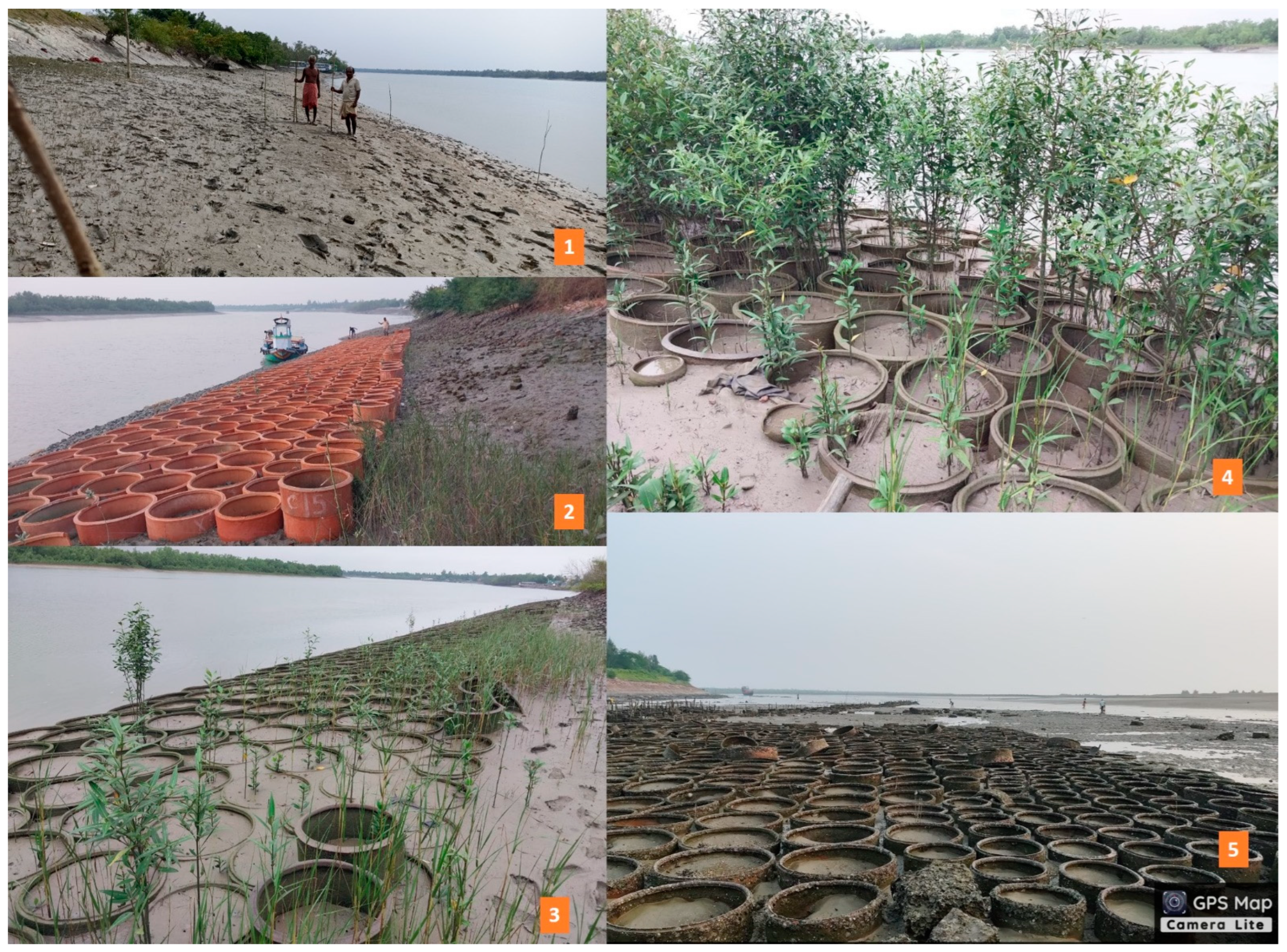
- (a)
- silt entrapment in terracotta rings, and
- (b)
- mangrove regeneration in trapped silt.
2. Materials and Methods
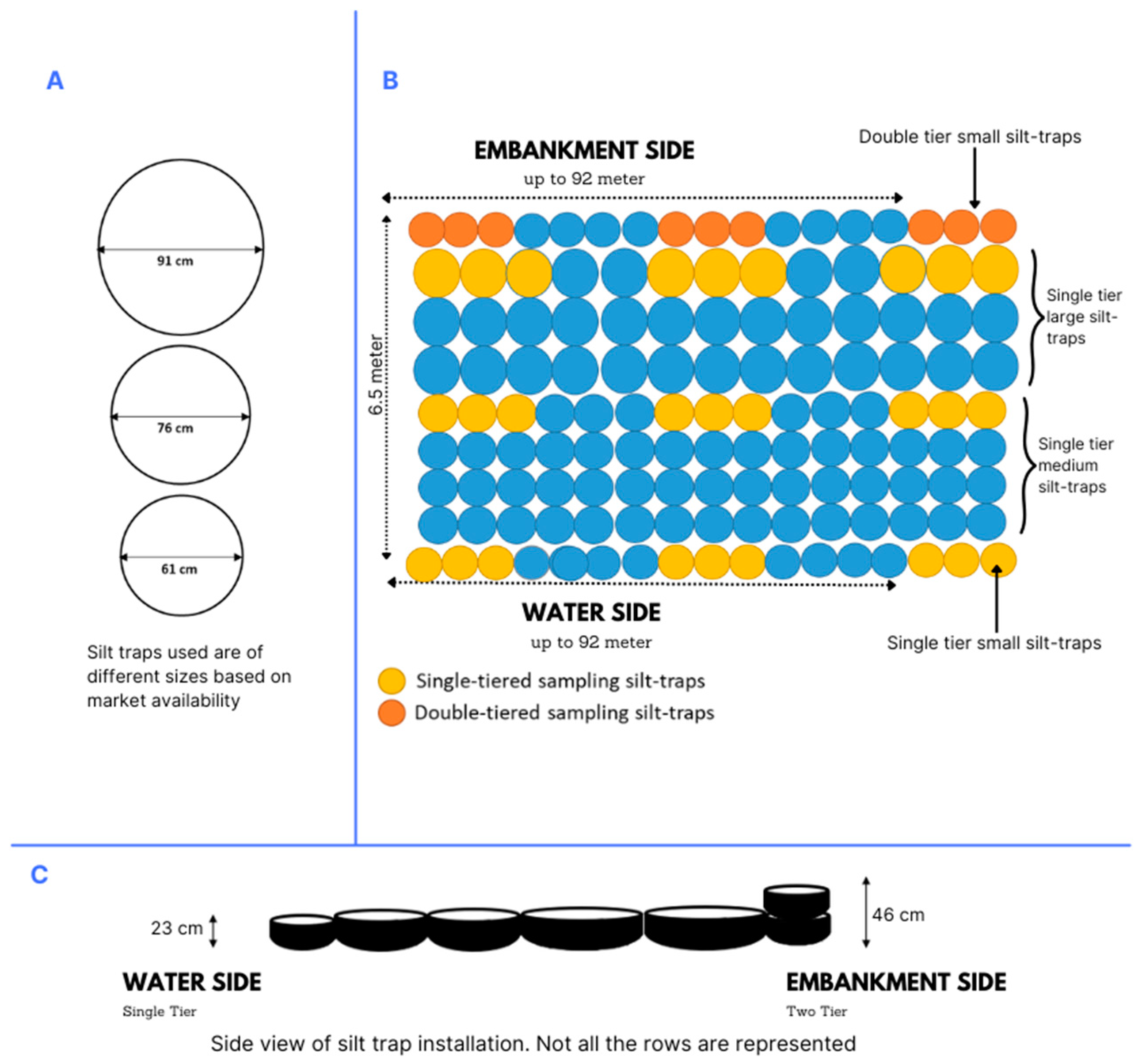
2.1. Methodology and Experimental Setup
2.2. Intervention Design
2.3. Monitoring of Sediment Deposition
3. Results
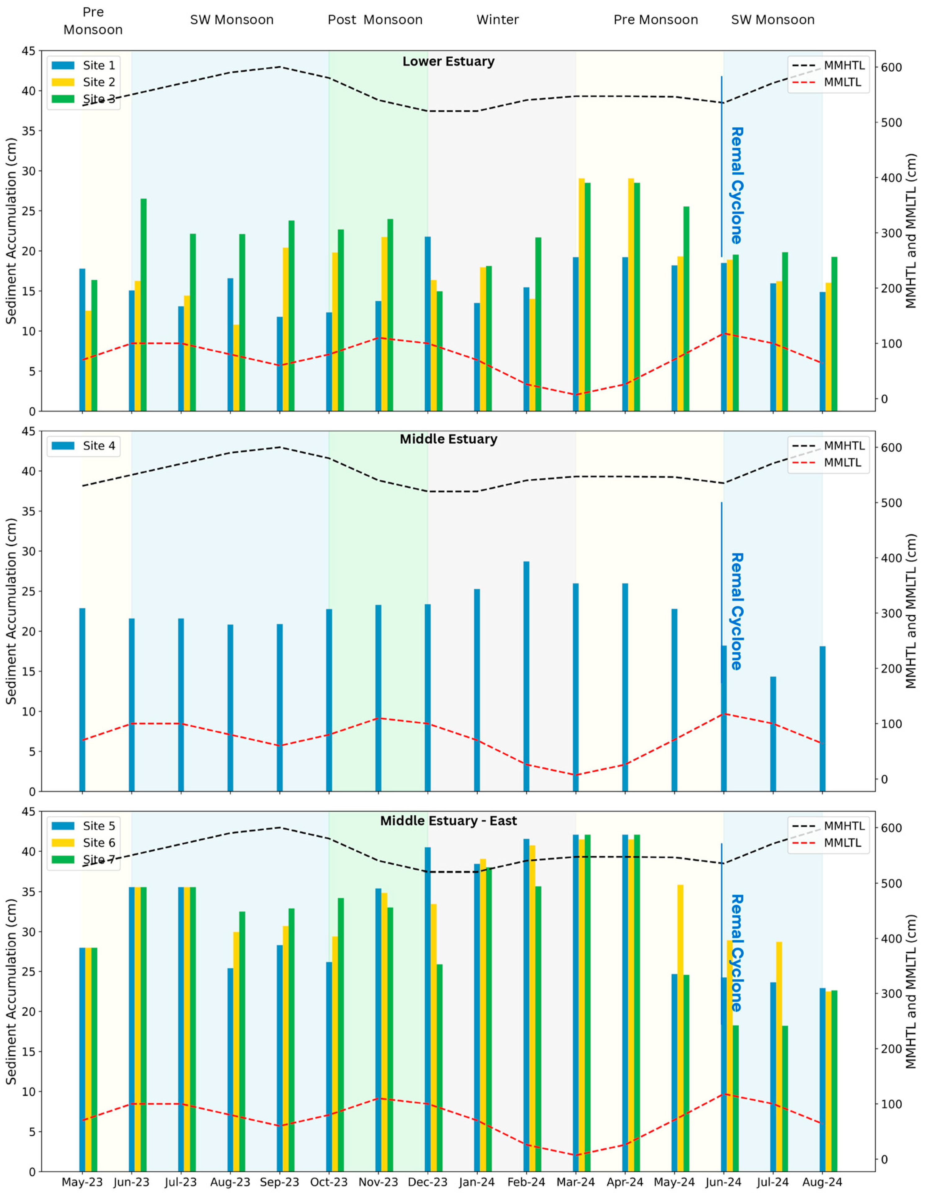
3.1. Net Sediment Accumulation over 12 Months
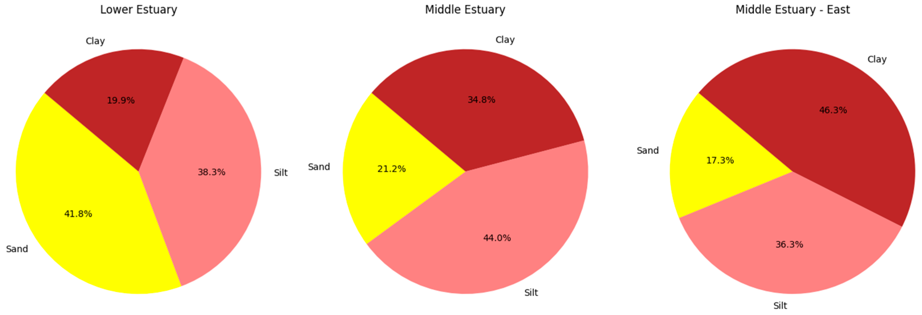
3.2. Granulometric Variations Among Different Estuary Locations
3.3. Growth of Mangroves and Oysters in Silt Traps
4. Discussion
5. Conclusions
6. Limitations of the Study
Author Contributions
Funding
Institutional Review Board Statement
Informed Consent Statement
Data Availability Statement
Acknowledgments
Conflicts of Interest
References
- Department of Environment. Protection of Coastal Areas and Earthen Embankment Through Vegetative Solutions. Government of West Bengal. 2021. Available online: https://www.wbpcb.gov.in/files/Tu-08-2021-08-23-18Report_Final.pdf (accessed on 10 November 2024).
- Survey of India. Hugli River Tide Tables for Sagar, Gangra, Haldia, Daimon Harbour, Mayapur, and Garden Reach; Geodetic and Research Branch of Survey of India: Dehradun, India, 2023; 179p. [Google Scholar]
- The World Bank. Building Resilience for Sustainable Development of the Sundarbans; World Bank Group: Washington, DC, USA, 2014; Available online: https://documents1.worldbank.org/curated/en/879351468259748207/pdf/880610REVISED00ns000Strategy0Report.pdf (accessed on 18 February 2025).
- Irrigation and Waterways Department. Aila. Irrigation and Waterways Department, Government of West Bengal. 2010. Available online: https://wbiwd.gov.in/index.php/applications/aila (accessed on 10 November 2024).
- Ghosh, S.; Mistri, B. Analyzing the multi-hazard coastal vulnerability of Matla–Bidya inter-estuarine area of Indian Sundarbans using analytical hierarchy process and geospatial techniques. Estuarine Coast. Shelf Sci. 2022, 279, 108144. [Google Scholar] [CrossRef]
- Department of Sundarban Affairs. Block profile. Government of West Bengal. Available online: https://www.sundarbanaffairswb.in/home/block (accessed on 10 November 2024).
- Allison, M.A.; Khan, S.R.; Goodbred, S.L.; Kuehl, S.A. Stratigraphic evolution of the late Holocene Ganges–Brahmaputra lower delta plain. Sediment. Geol. 2003, 155, 317–342. [Google Scholar] [CrossRef]
- Danda, A.A.; Ghosh, N.; Bandyopadhyay, J.; Hazra, S. Managed retreat: Adaptation to climate change in the Sundarbans ecoregion in the Bengal Delta. J. Indian Ocean Reg. 2019, 15, 317–335. [Google Scholar] [CrossRef]
- Samanta, S.; Hazra, S.; Mondal, P.P.; Chanda, A.; Giri, S.; French, J.R.; Nicholls, R.J. Assessment and Attribution of Mangrove Forest Changes in the Indian Sundarbans from 2000 to 2020. Remote Sens. 2021, 13, 4957. [Google Scholar] [CrossRef]
- Wong, P.P.; Losada, I.J.; Gattuso, J.-P.; Hinkel, J.; Khattabi, A.; McInnes, K.L.; Saito, Y.; Sallenger, A. Coastal systems and low-lying areas. In Climate Change 2014: Impacts, Adaptation, and Vulnerability. Part A: Global and Sectoral Aspects. Contribution of Working Group II to the Fifth Assessment Report of the Intergovernmental Panel on Climate Change; Field, C.B., Barros, V.R., Dokken, D.J., Mach, K.J., Mastrandrea, M.D., Bilir, T.E., Chatterjee, M., Ebi, K.L., Estrada, Y.O., Genova, R.C., et al., Eds.; Cambridge University Press: Cambridge, UK; New York, NY, USA, 2014; pp. 361–409. [Google Scholar]
- Paszkowski, A.; Goodbred, S.; Borgomeo, E.; Alam Khan, M.S.; Hall, J.W. Geomorphic change in the Ganges–Brahmaputra–Meghna delta. Nat. Rev. Earth Environ. 2021, 2, 763–780. [Google Scholar] [CrossRef]
- Syvitski, J.P.M.; Kettner, A.J.; Overeem, I.; Hutton, E.W.H.; Hannon, M.T.; Brakenridge, G.R.; Day, J.; Vörösmarty, C.; Saito, Y.; Giosan, L.; et al. Sinking Deltas Due to Human Activities. Nat. Geosci. 2009, 2, 681–686. [Google Scholar] [CrossRef]
- Giosan, L.; Constantinescu, S.; Clift, P.D.; Tabrez, A.R.; Danish, M.; Inam, A. Recent morphodynamics of the Indus delta shore and shelf. Cont. Shelf Res. 2006, 26, 1668–1684. [Google Scholar] [CrossRef]
- Oppenheimer, M.; Glavovic, B.C.; Hinkel, J.; van de Wal, R.; Magnan, A.K.; Abd-Elgawad, A.; Cai, R.; Cifuentes-Jara, M.; DeConto, R.M.; Ghosh, T.; et al. Sea Level Rise and Implications for Low-Lying Islands, Coasts and Communities. IPCC Special Report on the Ocean and Cryosphere in a Changing Climate. 2019. Available online: https://www.ipcc.ch/site/assets/uploads/sites/3/2019/11/08_SROCC_Ch04_FINAL.pdf (accessed on 18 February 2025).
- Smith, C.S.; Rudd, M.E.; Gittman, R.K.; Melvin, E.C.; Patterson, V.S.; Renzi, J.J.; Wellman, E.H.; Silliman, B.R. Coming to Terms With Living Shorelines: A Scoping Review of Novel Restoration Strategies for Shoreline Protection. Front. Mar. Sci. 2020, 7, 434. [Google Scholar] [CrossRef]
- O’Donnell, J.E. Living Shorelines: A Review of Literature Relevant to New England Coasts. J. Coast. Res. 2017, 332, 435–451. [Google Scholar] [CrossRef]
- Currin, C.A.; Chappell, W.S.; Deaton, A. Developing alternative shoreline armoring strategies: The living shoreline approach in North Carolina. In Puget Sound Shorelines and the Impacts of Armoring: Proceedings of a State of the Science Workshop; Shipman, H., Dethier, M.N., Gelfenbaum, G., Fresh, K.L., Dinicola, R.D., Eds.; U.S.G.S. Scientific Investigations Report 2010-5254; U.S. Geological Survey: Reston, VA, USA, 2009; pp. 91–102. Available online: https://pubs.usgs.gov/sir/2010/5254/pdf/sir20105254_chap10.pdf (accessed on 18 February 2025).
- Chowdhury, M.S.N.; Walles, B.; Sharifuzzaman, S.; Hossain, M.S.; Ysebaert, T.; Smaal, A.C. Oyster breakwater reefs promote adjacent mudflat stability and salt marsh growth in a monsoon dominated subtropical coast. Sci. Rep. 2019, 9, 8549. [Google Scholar] [CrossRef]
- Gittman, R.K.; Peterson, C.H.; Currin, C.A.; Fodrie, F.J.; Piehler, M.F.; Bruno, J.F. Living shorelines can enhance the nursery role of threatened estuarine habitats. Ecol. Appl. 2016, 26, 249–263. [Google Scholar] [CrossRef] [PubMed]
- Polk, M.A.; Eulie, D.O. Effectiveness of Living Shorelines as an Erosion Control Method in North Carolina. Estuaries Coasts 2018, 41, 2212–2222. [Google Scholar] [CrossRef]
- Sandilyan, S.; Kandasamy, K. Mangrove conservation: A global perspective. Biodivers. Conserv. 2012, 21, 3523–3542. [Google Scholar] [CrossRef]
- Mancheño, A.G.; Vuik, V.; van Wesenbeeck, B.B.; Jonkman, B.S.; van Hespen, R.; Kazi, S.; Urrutia, I.; van Ledden, M.; Moll, R.J. Integrating mangroves in dike designs: Effect of tree growth and failure. Prepr. Res. Sq. 2023. preprint. [Google Scholar] [CrossRef]
- Nguyen, T. Melaleuca entrapping microsites as a nature based solution to coastal erosion: A pilot study in Kien Giang, Vietnam. Ocean Coast. Manag. 2018, 155, 98–103. [Google Scholar] [CrossRef]
- Fauzi, N.F.M.; Min, T.H.; Hashim, A.M. Assessment of Mangrove Replanting Site at Kg Tanjung Kepah, Lekir, Perak. IOP Conf. Ser. Earth Environ. Sci. 2020, 549, 012054. [Google Scholar] [CrossRef]
- Pande, B.M. Ring wells in ancient India. Bull. Deccan Coll. Post-Grad. Res. Inst. 1966, 25, 207–219. Available online: https://www.jstor.org/stable/42930851 (accessed on 18 February 2025).
- Chauhan, R.; Ramanathan, A.L.; Adhya, T.K. Patterns of seasonal variability in granulometric characteristics of Bhitarkanika Mangrove–estuarine complex, East coast of India. Indian J. Geo-Mar. Sci. 2014, 43, 1083–1090. [Google Scholar]
- Survey of India. Hugli River Tide Tables for Sagar, Gangra, Haldia, Daimon Harbour, Mayapur, and Garden Reach; Geodetic and Research Branch of Survey of India: Dehradun, India, 2024; 176p. [Google Scholar]
- Paul, S.; Das, C.S.; Chaudhuri, S. Seasonal vertical accretion in different hydro-geomorphic environments of Indian Sundarban: Assessing the role of mangroves in mitigating sea level rise impacts. Geomorphology 2024, 467, 109493. [Google Scholar] [CrossRef]
- Balke, T.; Bouma, T.J.; Horstman, E.M.; Webb, E.L.; Erftemeijer, P.L.A.; Herman, P.M.J. Windows of opportunity: Thresholds to mangrove seedling establishment on tidal flats. Mar. Ecol. Prog. Ser. 2011, 440, 1–9. [Google Scholar] [CrossRef]
- Lovelock, C.E.; Cahoon, D.R.; Friess, D.A.; Guntenspergen, G.R.; Krauss, K.W.; Reef, R.; Rogers, K.; Saunders, M.L.; Sidik, F.; Swales, A.; et al. The vulnerability of Indo-Pacific mangrove forests to sea-level rise. Nature 2015, 526, 559–563. [Google Scholar] [CrossRef] [PubMed]
- Murthy, M.V.R.; Ravichandran, V.; Vendhan, M.; Kiran, A.S.; Raju, S.K.; Avula, A.K.; Varthini, S.; Abhishek, T. Shore Protection Measures along Indian Coast—Design to Implementation Based on Two Case Studies. Curr. Sci. 2020, 118, 1768–1773. [Google Scholar] [CrossRef]
- Van Tien, H.; Anh, N.T.; Phong, N.T.; Nhut, M.L.M. Ecological Engineering and Restoration of Eroded Muddy Coasts in South East Asia: Knowledge Gaps and Recommendations. Sustainability 2021, 13, 1248. [Google Scholar] [CrossRef]
- Shahriar, B.A.M. Development of Climate Resilient Slope Protection for Dykes in Saline Zones of Bangladesh. Master’s Thesis, Bangladesh University of Engineering and Technology, Dhaka, Bangladesh, 2015. [Google Scholar]
- Mita, K.S. Role of Mangrove Plantation in Improving Embankment Safety and Supporting Local Livelihoods. Master’s Thesis, Bangladesh University of Engineering and Technology, Dhaka, Bangladesh, 2019. [Google Scholar]
- Raff, J.L.; Goodbred, S.L.; Pickering, J.L.; Sincavage, R.S.; Ayers, J.C.; Hossain, S.; Wilson, C.A.; Paola, C.; Steckler, M.S.; Mondal, D.R.; et al. Sediment delivery to sustain the Ganges-Brahmaputra delta under climate change and anthropogenic impacts. Nat. Commun. 2023, 14, 2429. [Google Scholar] [CrossRef]
- Bhadra, T.; Mukhopadhyay, A.; Hazra, S. Identification of river discontinuity using geo-informatics to improve freshwater flow and ecosystem services in Indian Sundarban Delta. In Environmental and Earth Observation; Hazra, S., Ghosh, A., Mitra, D., Dadhwal, V., Eds.; Springer Remote Sensing/Photogrammetry; Springer: Cham, Switzerland, 2017; pp. 137–152. [Google Scholar] [CrossRef]
- Samanta, S.; Hazra, S.; French, J.R.; Nicholls, R.J.; Mondal, P.P. Exploratory modelling of the impacts of sea-level rise on the Sundarbans mangrove forest, West Bengal, India. Sci. Total. Environ. 2023, 903, 166624. [Google Scholar] [CrossRef] [PubMed]
- Bandyopadhyay, S. Sundarban: A Review of Evolution and Geomorphology; World Bank Group: Washington, DC, USA, 2019; Available online: https://documents1.worldbank.org/curated/en/119121562735959426/pdf/Sundarban-A-Review-of-Evolution-and-Geomorphology.pdf (accessed on 18 February 2025).
- United Nations Environment Programme. Nature-based Solutions: Opportunities and Challenges for Scaling Up. 2022. Available online: https://wedocs.unep.org/20.500.11822/40783 (accessed on 10 November 2024).
- Albert, C.; Brillinger, M.; Guerrero, P.; Gottwald, S.; Henze, J.; Schmidt, S.; Ott, E.; Schröter, B. Planning nature-based solutions: Principles, steps, and insights. AMBIO 2021, 50, 1446–1461. [Google Scholar] [CrossRef]


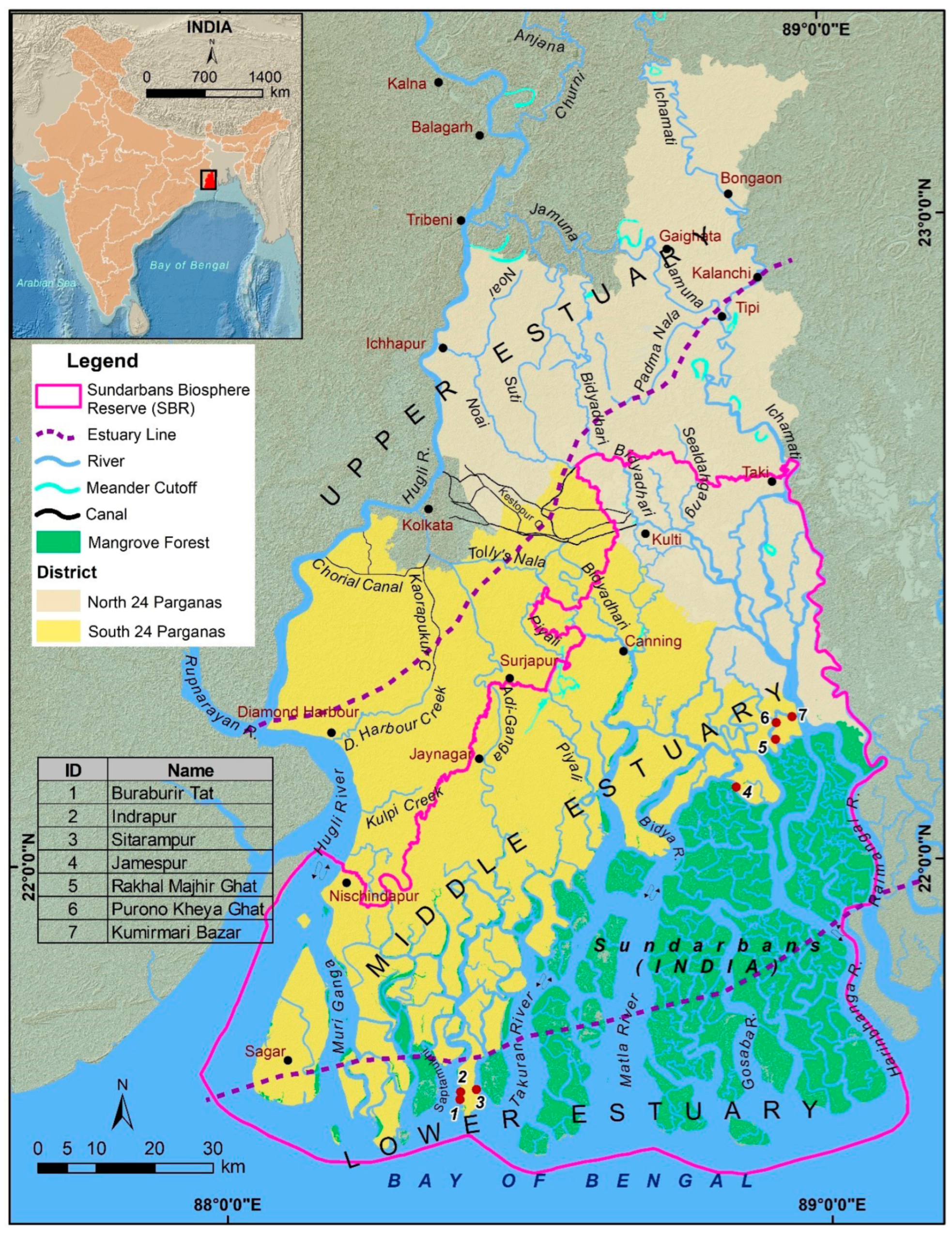
| Site ID | Site Name and Time of Installation | Lat | Long | Distance from Sea (km) | Aspect | Area (m2) |
|---|---|---|---|---|---|---|
| 1 | Buraburir Tat: June 2022 | 21.63476 | 88.38607 | 15.38 | N-S (170°) | 600 |
| 2 | Indrapur: November 2022 | 21.64649 | 88.38712 | 16.5 | N-S (190°) | 600 |
| 3 | Sitarampur: December 2022 | 21.64978 | 88.41336 | 16.8 | NW-SE (140°) | 600 |
| 4 | Jamespur: September 2022 | 22.11456 | 88.84981 | 62.66 | N-S (175°) | 727 |
| 5 | Rakhal Majhir Ghat: January 2023 | 22.18778 | 88.91619 | 69.45 | NW-SE (145°) | 577 |
| 6 | Purono Kheya Ghat: February 2023 | 22.21382 | 88.91765 | 72.33 | N-S (170°) | 477 |
| 7 | Kumirmari Bazar: February 2023 | 22.22277 | 88.94387 | 73.1 | E-W (260°) | 103 |
| Site ID | Island Location | Site Position on the Island | Average Sediment Thickness (cm) | Range of Sediment Thickness (cm) |
|---|---|---|---|---|
| 1 | Lower estuary | West | 16.06 ± 2.85 | 11.76–21.77 |
| 2 | Lower estuary | West | 18.31 ± 5.11 | 10.80–29.06 |
| 3 | Lower estuary | East | 22.09 ± 4.00 | 14.96–28.50 |
| 4 | Middle estuary | South West | 22.28 ± 3.48 | 14.33–28.70 |
| 5 | Middle estuary | West | 32.15 ± 7.38 | 22.91–42.06 |
| 6 | Middle estuary | West | 33.51 ± 5.53 | 22.50–41.48 |
| 7 | Middle estuary | East | 31.19 ± 7.53 | 18.21–42.06 |
Disclaimer/Publisher’s Note: The statements, opinions and data contained in all publications are solely those of the individual author(s) and contributor(s) and not of MDPI and/or the editor(s). MDPI and/or the editor(s) disclaim responsibility for any injury to people or property resulting from any ideas, methods, instructions or products referred to in the content. |
© 2025 by the authors. Licensee MDPI, Basel, Switzerland. This article is an open access article distributed under the terms and conditions of the Creative Commons Attribution (CC BY) license (https://creativecommons.org/licenses/by/4.0/).
Share and Cite
Chatterjee, P.; Hazra, S.; Danda, A.A.; Bhadury, P.; Chaudhuri, P.; Sarkar, S. Living Shoreline: Preliminary Observations on Nature-Based Solution for Toe-Line Protection of Estuarine Embankments and Mangrove Regeneration. Sustainability 2025, 17, 3168. https://doi.org/10.3390/su17073168
Chatterjee P, Hazra S, Danda AA, Bhadury P, Chaudhuri P, Sarkar S. Living Shoreline: Preliminary Observations on Nature-Based Solution for Toe-Line Protection of Estuarine Embankments and Mangrove Regeneration. Sustainability. 2025; 17(7):3168. https://doi.org/10.3390/su17073168
Chicago/Turabian StyleChatterjee, Paromit, Sugata Hazra, Anamitra Anurag Danda, Punyasloke Bhadury, Punarbasu Chaudhuri, and Sampurna Sarkar. 2025. "Living Shoreline: Preliminary Observations on Nature-Based Solution for Toe-Line Protection of Estuarine Embankments and Mangrove Regeneration" Sustainability 17, no. 7: 3168. https://doi.org/10.3390/su17073168
APA StyleChatterjee, P., Hazra, S., Danda, A. A., Bhadury, P., Chaudhuri, P., & Sarkar, S. (2025). Living Shoreline: Preliminary Observations on Nature-Based Solution for Toe-Line Protection of Estuarine Embankments and Mangrove Regeneration. Sustainability, 17(7), 3168. https://doi.org/10.3390/su17073168