Article

Sustainable Heritage Planning for Urban Mass Tourism and Rural Abandonment: An Integrated Approach to the Safranbolu–Amasra Eco-Cultural Route

by
Emre Karataş
1,*,
Aysun Özköse
1 and
Muhammet Ali Heyik
2
1
Department of Architecture, Karabük University, 78600 Karabük, Türkiye
2
Department of Architecture, Yıldız Technical University, 34349 İstanbul, Türkiye
*
Author to whom correspondence should be addressed.
Sustainability 2025, 17(7), 3157; https://doi.org/10.3390/su17073157
Submission received: 12 February 2025 / Revised: 21 March 2025 / Accepted: 27 March 2025 / Published: 2 April 2025

Abstract

:
Urban mass tourism and rural depopulation increasingly threaten heritage sites worldwide, leading to socio-economic and environmental challenges. This study adopts a holistic approach to sustainable tourism planning by examining 84 cultural and natural heritage sites in and around Safranbolu and Amasra, two cities in Türkiye that are listed on the UNESCO World Heritage List and the Tentative List. Inspired by historical travelers’ itineraries, it proposes an eco-cultural tourism route to create a resilient heritage network. A participatory methodology integrates charettes within Erasmus+ workshops, crowdsourcing, various analysis methods while engaging stakeholders, and AI-powered clustering for route determination. The study follows a four-stage framework: (1) data collection via collaborative GIS, (2) eco-cultural route development, (3) stakeholder participation for inclusivity and viability, and (4) assessments and recommendations. Results highlight the strong potential of heritage assets for sustainable tourism while identifying key conservation risks. Interviews and site analysis underscore critical challenges, including the absence of integrated site management strategies, insufficient capacity-building initiatives, and ineffective participatory mechanisms. Moreover, integrating GIS-based crowdsourcing, machine learning clustering, and multi-criteria decision-making can be an effective planning support system. In conclusion, this study enhances the sustainability of heritage and tourism by strengthening participatory eco-cultural development and mitigating mass tourism and abandonment’s negative impacts on the heritage sites.

Graphical Abstract

1. Introduction

Ecotourism integrates heritage conservation, local communities, and sustainable travel [1]. Eco-cultural routes and trails reinterpret pathways by embedding them with historical values, memories, narratives, and heritage, assigning them new meanings and significance [2].
Recent studies explore their role in heritage preservation through sustainable tourism. Zhang et al. (2025) highlight the role of eco-cultural networks in integrating cultural heritage and ecological resources within a sustainable network [3]. Lukoseviciute et al. (2024) develop a stakeholder-driven eco-cultural trail management strategy, balancing conservation and tourism [4]. Lin et al. (2024) provide a global review of cultural routes, analyzing 38 cases in terms of distribution, typology, planning, and tourism tools [5]. Trakala et al. (2023) map, assess, and propose eco-cultural tourism routes, estimating their carrying capacity for sustainable area management [6]. Zhou and Zheng (2022) examine their role in connecting scattered villages and fostering a multicultural model for rural development [7].
This approach offers visitors the opportunity to engage with nature and culture in a sustainable manner, in alignment with the principles of ecotourism [4]. The development of tourism within routes in the context of natural and cultural values is often promoted by governments, non-profit organizations, and various international institutions such as ICOMOS, UNWTO, and the Council of Europe (COE). Such planning processes encompass a wide range of objectives, including the preservation and promotion of heritage, enhancing social interaction and collaboration, supporting sustainable development through culture, sports, arts, research, and education, developing unique tourism products, improving visitor experiences, and ensuring sustainability within heritage sites [8,9,10,11,12].
Around the world, there are tourism routes of various scales that embrace journey-based memories and narratives as their central theme. For example, Route 66 in the USA spans multiple states and reflects values associated with national identity [13]. The Santiago de Compostela Routes, one of the most significant pilgrimage paths for Christians since the Middle Ages, serve to connect countries across Western Europe [14]. There are also route examples that trace the journeys of historical travelers such as Marco Polo and Evliya Çelebi, who explored various parts of the world. Additionally, Stevenson’s Path is a regional example in southern France, following the 220 km journey of traveler and writer Robert Louis Stevenson while referencing the concept of responsible tourism [15]. The Lycian Way is Türkiye’s first long-distance heritage route, extending 760 km from Fethiye to Antalya. It is renowned for its wealth of ancient cities and the diverse natural landscapes of the Mediterranean region.
Conversely, the role in and impact of tourism on heritage sites have become increasingly prominent topics in scholarly debates over the past decades. Inhabited areas, in particular, have witnessed the adverse consequences of urban mass tourism, including the restriction of local residents’ access to essential urban services, shifts in traditional lifestyles, declines in socio-economic well-being, and an increase in the displacement and depopulation of local communities. In cultural heritage sites, tourism may lead to physical degradation and cultural erosion due to profit-driven exploitation of urban spaces and heritage [16,17,18]. Moreover, the uncontrolled expansion of coastal tourism—fueled by large-scale projects, excessive urbanization, sprawling hotels, and marinas—poses significant threats to natural areas and fragile ecotonal systems. In particular, the coasts, which have long been exposed to the destructive impacts of mass tourism, are witnessing the irreversible degradation of their ecological habitats [19].
Urban areas are the largest contributors to climate change, accounting for 71% to 76% of global CO2 emissions [20]. At the same time, they are among the most vulnerable regions, highly susceptible to the impacts of climate change, as well as to other crises, including wars, pandemics, and economic crises [20,21]. In 1960, 66% of the global population resided in rural areas, whereas by 2023, this figure had declined to 43% [22]. The decline in the rural population alongside the growth of the urban population weakens socio-economic resilience and adversely affects heritage sites in rural areas. In Türkiye, this demographic shift has been even more dramatic. According to World Bank data, while 68% of the population lived in rural areas in 1960, this figure had dropped to 23% by 2023 [23]. Due to rural abandonment, production has come to a complete halt in many settlements, leading to the loss of deeply rooted heritage sites [24,25].
The tourism sector in Türkiye has become increasingly significant in recent years. As of 2023, Türkiye ranked as the fifth most visited country globally. With over 76 million domestic tourists, tourism emerges as a critical factor in balancing rural and urban population dynamics while contributing to the sustainable preservation of heritage sites [26].
The research focuses on the Western Black Sea region of Türkiye and specifically two significant historical towns: Safranbolu and Amasra. Safranbolu, situated in Karabük Province, is recognized as a UNESCO World Heritage Site for its well-preserved Ottoman architecture. Amasra, part of Bartın Province, is listed on the Tentative List of UNESCO World Heritage Sites under the title “Trading Posts and Fortifications on Genoese Trade Routes from the Mediterranean to the Black Sea”. Both towns have faced considerable challenges in tourism management and planning in recent years. UNESCO reports, and various studies indicate that, particularly during peak tourist seasons, visitor numbers exceed the towns’ carrying capacities. This massive tourism leads to adverse effects on local communities, disrupts daily life, and poses significant threats to both cultural and natural heritage in the region [27,28,29,30,31,32,33,34]. The prolonged pressure of mass tourism has recently sparked debates over the reduction of protected site boundaries and non-sensitive urban plans, particularly concerning the preservation of cultural heritage [31]. On the other hand, migration and abandonment in the region’s vast rural areas are irreversibly impacting heritage sites, socio-cultural memory, and collective consciousness in a negative manner [35]. The pandemic period clearly revealed how rural abandonment and dependence on mass tourism have rendered the region highly vulnerable.
Within the framework of the Western Black Sea Tourism Master Plan, the creation and promotion of thematic cultural routes have been identified as key strategies. Over the past five years, various initiatives have been introduced in Karabük and Bartın provinces to develop tourism routes aimed at extending visitor stays, diversifying tourism revenues, fostering branding, enhancing promotion, and supporting product development and planning efforts [36]. However, the unplanned development of mass tourism and the increasing abandonment of heritage sites highlight the urgent need for comprehensive planning to control tourism levels and mitigate their impacts. The pandemic, as a minor reflection of the climate crisis, has clearly demonstrated how rural abandonment and dependence on mass tourism have made the region highly vulnerable.
The study area encompasses the cities of Safranbolu and Amasra, along with the natural and cultural heritage surrounding 82 sites (Figure 1). This study introduces an eco-cultural route aimed at guiding tourism planning in the region to foster sustainable conservation and development. The proposed route integrates the journeys of five travelers who visited the region during the 19th and early 20th centuries. These travelers documented the region’s significant natural and cultural assets, each from the perspective of their respective fields of study.
By promoting lesser-known and mostly abandoned vernacular landscapes, the proposed route supports sustainable tourism while preserving the cultural and natural heritage of the region. It fosters economic resilience, encourages the return of local communities, and mitigates the adverse effects of mass tourism in central heritage sites. Additionally, it adopts a participatory approach to route planning, ensuring a viable and inclusive tourism strategy that balances visitor distribution across multiple sites, thereby preventing over-tourism in significant destinations such as Safranbolu and Amasra. Building on participatory approaches to ecotourism in the region’s collective memory, this study marks the initial phase of a broader agenda that is expected to inspire new research questions, interdisciplinary studies, and pilot projects in the future.
Methodologies related to route proposals in the literature vary depending on their context and objectives. Unlike many qualitative studies, several researchers employ analytical techniques to develop or evaluate routes [37,38]. This study aims to fill a significant gap in the literature on tourism route planning in complex contexts by incorporating mixed data collection and analysis methods, including Geographic Information Systems (GIS), Analytic Hierarchy Process (AHP), clustering, SWOT analysis, charrette workshops, and interviews.
Furthermore, there is a gap in research addressing their systematic development planning in the early stages of route proposals and through participatory and data-driven methods within the context of heritage conservation in Türkiye and its Black Sea region [5]. This study seeks to bridge this gap by proposing an eco-cultural tourism route based on a replicable model that harnesses collective intelligence, historical narratives, and extensive site analysis. The study area offers a valuable opportunity to examine globally prevalent issues in heritage sites, such as rural abandonment and urban mass tourism.

2. Materials and Methods

This article focuses on the initial phase of developing a tourism route, emphasizing the capacity development of the sites and their integration into a cohesive and resilient route scenario. To achieve this, a heritage-based participatory strategy has been developed, aiming to preserve cultural and natural heritage, enhance the well-being of local communities, and promote sustainable development.
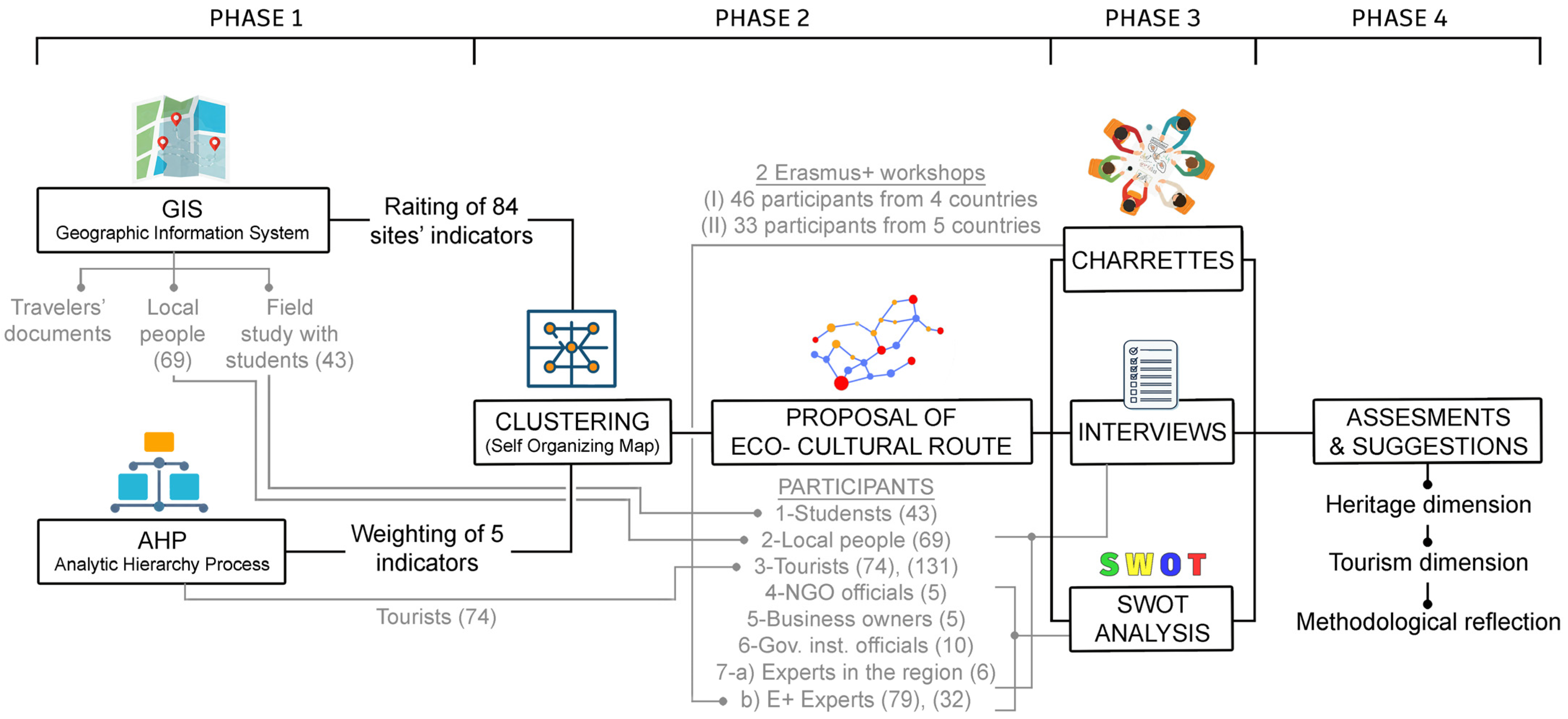
The methodology adopts an integrated approach, combining diverse data sources with insights from various stakeholder groups. It consists of four interrelated phases, characterized by participatory methods, as outlined below (Figure 2):
  • Data collection and analysis,
  • Development of the eco-cultural route proposal,
  • Stakeholder participation to ensure inclusivity and viability,
  • Overall assessment and policy recommendations.
The methods employed and their benefits are outlined as follows:
  • Geographic Information System (GIS): It facilitates data collection for 84 sites through crowdsourcing field studies, with sites’ data being analyzed according to five indicators and ratings being assigned to each site’s indicators.
  • Analytic Hierarchy Process (AHP): The 5 indicators used in GIS analysis are weighted through surveys using the Saaty scale (1–9) to identify tourist preferences in the field.
  • Clustering: Based on the normalized ratings for each site’s 5 indicators obtained from GIS and the indicator weights obtained from AHP, the sites are clustered using Self-organizing Map (SOM), which is a neural network algorithm. According to their similar characteristics, site potential levels (high, medium, and low) are then determined.
  • SWOT Analysis: A comprehensive analysis of internal and external factors regarding the proposed eco-cultural route with stakeholders, and data (strengths, weaknesses, opportunities, and threats) are obtained to develop strategies.
  • Charrette: The data obtained through GIS, AHP, clustering, interviews, and SWOT analysis are evaluated using multidisciplinary workshops, the potential impacts of the eco-cultural route are discussed, and key strategies for planning are developed.

2.1. Data Collection

2.1.1. Documents of Historical Travelers

Before the Industrial Revolution, commercial activities, production infrastructure, military facilities, administrative units, and population centers were concentrated along the Silk Road. These routes also served as one of the most influential channels for cultural exchange [39]. After the mid-17th century, Safranbolu emerged as one of the prominent settlements along the Istanbul-Tabriz branch of the Silk Road [40]. Although the region was close to important centers on the Silk Road in Asia Minor, it did not attract the attention of researchers and travelers until the 19th century, the late period of the Ottoman Empire. This part of Anatolia, which deeply impressed travelers with its picturesque appearance and untouched features, has been a focus of researchers and travelers from the first quarter of the 19th century to the beginning of the 20th century.
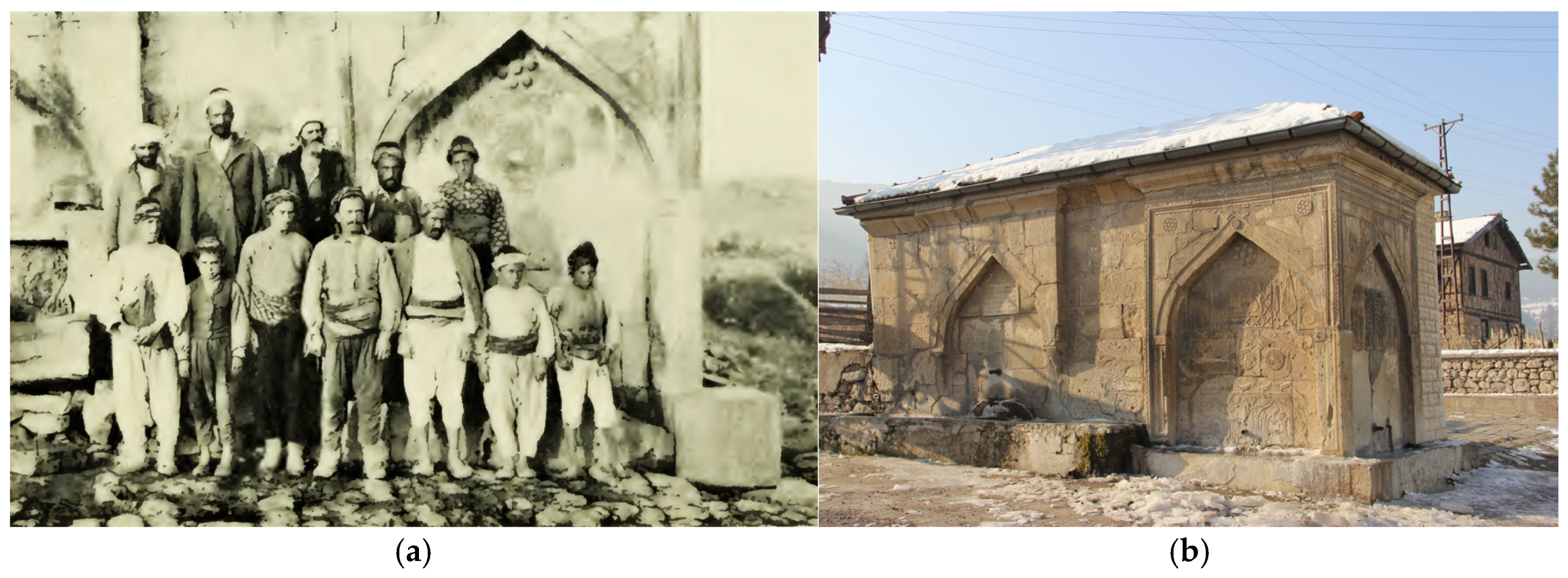
To plan the eco-cultural route, the travel routes of five travelers with sufficient data regarding their journeys are identified and analyzed. These investigations specifically provide insights into different perspectives on the local history, transportation, and socio-economic structure of the period by utilizing information, maps, and photographs (Figure 3). Ainsworth (1836) provided detailed information on geographical, geological, and archaeological values; Mordtmann (1856) on social and political structure; Anton (1893) on transportation routes, production methods, and archaeological values; Leonhard (1903) on geographical, geological, and archaeological values; and Woods (1906) on transportation routes, the condition of the roads, and social structure in that period [41,42,43,44,45].
The works written by travelers in various languages were used to identify the historical traveler routes. The settlements mentioned in the travelers’ writings and maps were cross-referenced with the field.

2.1.2. Field Study

The study examined 84 sites, incorporating historical traveler routes. A comprehensive range of tangible cultural heritage (TCH), intangible cultural heritage (ICH), natural heritage (NH), and other site-specific attributes were systematically identified and documented. Data collection employed a multi-source approach, incorporating written, printed, and electronic materials; official protected area designations and registration lists issued by governmental authorities [46,47]; direct field observations; and semi-structured interviews with local community members.
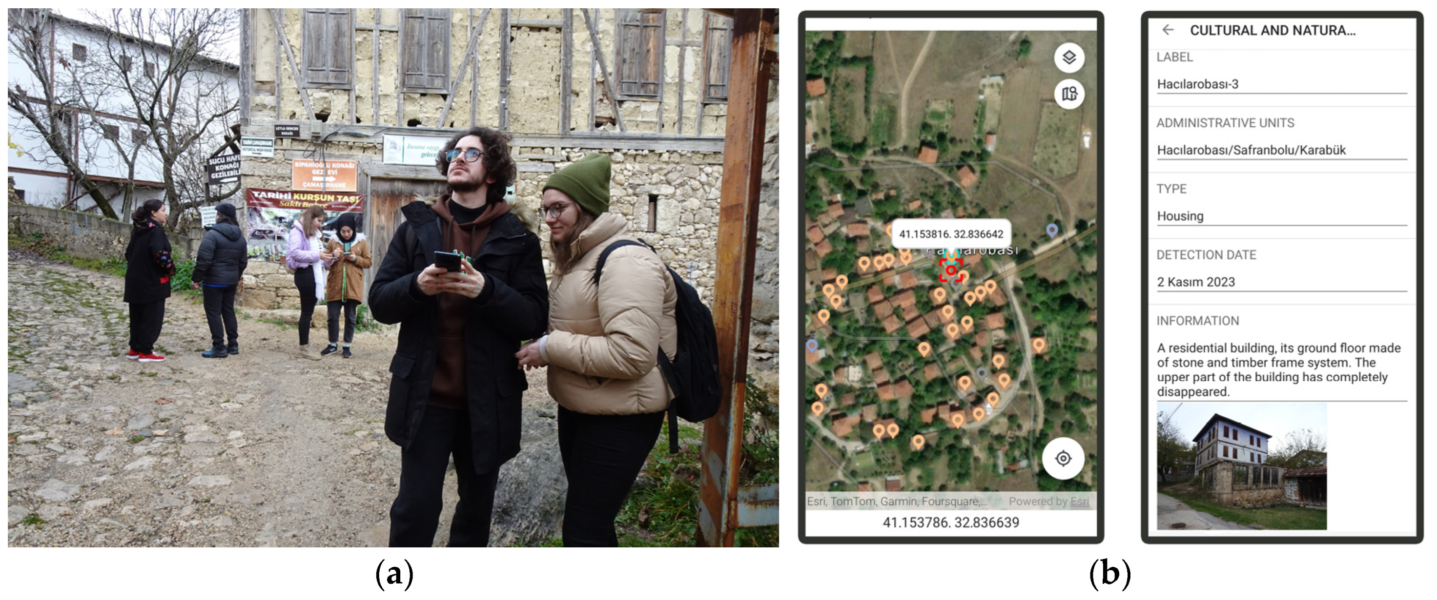
The documentation process was augmented by the participation of 43 students enrolled in conservation and restoration courses during the Fall and Spring semesters of 2023–2024. As part of the fieldwork, photographs of heritage assets were captured, and corresponding electronic data forms were systematically compiled (Figure 4). The incorporation of crowdsourced data collection methodologies further reinforces the study’s broader research impact and participatory scope.

2.1.3. Stakeholders

The importance of stakeholder participation in sustainable tourism planning and the preservation of cultural heritage sites has long been recognized [48,49]. Recent meta-analysis of participatory design and planning practices indicates that stakeholder groups vary based on the context and participatory setting, with distinct empowerment levels such as informing, consulting, collaboration, and empowerment [50]. In studies on cultural routes and regional tourism planning, the formation of inclusive stakeholder groups is essential to ensure sustainable and contextually appropriate developments [25,51,52]. Accordingly, seven stakeholder groups were identified within the scope of this study: (1) students, (2) local people, (3) tourists, (4) NGOs, (5) business owners, (6) government institution officials, and (7) experts.
Semi-structured, face-to-face interviews were conducted with 69 residents across the study sites. The limited number of participants reflects the extensive depopulation observed in many villages, with certain settlements entirely devoid of residents. The interviews addressed key topics, including prominent cultural and natural heritage values, potential products for promotion, strategies for utilizing historic building stock, and site management approaches aimed at preserving local identity, supporting local production, encouraging reverse migration, and fostering sustainable development. Furthermore, the tourism potential of these settlements was examined. To ensure diverse perspectives, participants were encouraged to engage other community members during the interview process.
The field study was conducted with the participation of 43 university students studying in the field of cultural heritage conservation. The study also incorporated interviews with 131 tourists from the settlements of Safranbolu and Amasra; and 79 international experts participating through the Erasmus+ blended intensive program (2023–2024); 5 representatives from non-governmental organizations (NGOs) dedicated to the preservation of heritage and the promotion of regional tourism; 5 business stakeholders, including hotel, restaurant, and travel agency operators; 10 officials from government institutions directly engaged in heritage and tourism management; and 6 experts from universities in the region and museums specializing in heritage and tourism studies. A total of 348 individuals participated across different phases of the study—diagnosing problems, pooling ideas, deliberating solutions, and co-creation—thereby enhancing the depth, rigor, and comprehensiveness of the research.
This study was approved by the ethics committee of the author’s institution (2023/04-30, 18 May 2023). Informed consent was obtained from all subjects involved in the study. The authors informed all interviewees about the purpose of data collection and their rights.

2.2. Data Analysis

2.2.1. Data Management and Spatial Mapping at GIS

The literature indicates that geographic information systems (GIS) are widely used in similar studies focusing on route planning [25,53,54].
In this study, data pertaining to identified cultural and natural heritage values, along with other relevant parameters, were systematically archived within ArcMap 10.8, an integrated GIS platform and database designed to support comprehensive spatial analyses (Table S1).
Additionally, the Fulcrum mobile and web application [55] was used to obtain visual evidence and enter information about it. The crowdsourced, multi-layered field data collected through the mobile app not only supports the identification of endangered heritage assets but also provides a critical infrastructure for promoting their protection and registration by making this information openly accessible.
Indicators and parameters must be determined to analyze the study area and rate the sites. In particular, the identification of indicators is one of the most critical stages influencing the outcome. In the literature, indicators for tourism route development vary based on the route’s context, theme, and objectives. However, studies focusing on cultural and natural heritages commonly categorize indicators under three main headings: (1) cultural and social, (2) natural and ecological, and (3) infrastructure and transportation [37,56,57].
In developing the indicators and parameters for this study, the primary objective was to achieve meaningful and reliable scoring outcomes. To this end, both stakeholder perspectives and the specific characteristics of the sites were considered. Each site was assigned a raw score for each indicator, ranging from 0 to 3, based on predefined parameters (Table 1).
  • Tangible Cultural Heritage (TCH): This indicator evaluates architectural and archaeological assets within the examined sites and their immediate surroundings. The assessment criteria include the presence of archaeological sites (AS) and urban sites (US), the integrity of heritage elements, and the number of monumental structures. Data from the Turkish Ministry of Culture and Tourism database [46] and observations from fieldwork were used to inform this evaluation;
  • Intangible Cultural Heritage (ICH): This indicator encompasses belief and celebration rituals, traditional games, music, literature, cuisine, artisanal crafts, production methods, and trade culture. The identification of ICH relied not only on printed sources but also heavily on interviews conducted with local residents. The applicability and current influence of heritage elements were key criteria for determining appropriate parameters. Additionally, ICH provides valuable insights into the social dynamics and cultural activities present at each site;
  • Natural Heritage (NH): This indicator evaluates Natural Sites (NS), Wildlife Development Areas (WDA), Nature Parks (NP), Registered Caves (RC), potential conservation areas, and sustainable habitats. The identification of NS, WDA, NP, and RC, which are designated according to national legislation, was based on data from the Ministry of Environment, Urbanization, and Climate Change and the Ministry of Agriculture and Forestry [47,58]. Potential conservation areas and sustainable habitats were assessed through consultations with experts. Urban areas lacking nature conservation zones and habitats degraded by activities such as mining or quarrying were assigned a rating of “0”;
  • Accessibility to Basic Services (ABS): Three key services were identified as significantly contributing to the assessment of the examined sites: sale of basic goods (SBG), indicating the availability of essential items such as food, healthcare products, and hygiene goods; settings for social interaction (SSI), referring to spaces that facilitate social engagement, such as museums, exhibition halls, traditional coffee houses, and village meeting rooms; and accessibility to public transport (APT), defined by the presence of public transportation access points within 3 km of the site. For each of these services—SBG, SSI, and APT—1 point was added to the overall rating.
  • Connectivity with Attraction Centers (CAC): CAC measures the connectivity of sites to existing tourist destinations and major population centers. The identified attraction centers within the study area include Safranbolu, Amasra, Yörük, Hadrianoupolis, Karabük, and Bartın. To determine the appropriate parameter for each site, the average distance to the three nearest attraction centers was calculated. Ratings were assigned based on 15 km intervals, as shown in Table 1.

2.2.2. Multi-Criteria Decision-Making with AHP

Data used in decision-making processes for heritage and tourism management often contain qualitative evaluations. In such cases, it becomes essential for decision-makers to quantitatively assess which components best serve their objectives. The Analytic Hierarchy Process (AHP) is a multi-criteria decision-making method designed to quantitatively prioritize criteria through pairwise comparisons. The hierarchical structure established among indicators facilitates decision-making in complex problems, providing AHP to evaluate and rank alternatives [59].
  • The AHP-based route assessment consists of two main stages: (1) identification of indicators and parameters, and (2) weighting of indicators according to tourist preferences.
  • The AHP indicators must be consistent with the indicators used in site analysis to ensure the connection between site characteristics and tourist preferences. Identification of indicators and parameters was based on a combination of literature review, context, and expert evaluations (Table 1).
  • A type of survey was presented to tourists, created using the Saaty scale (1–9) [59], based on the comparisons of the 5 indicators (TCH, ICH, NH, ABS, CAC) with each other. As a result of comparing the indicators in pairs, a decision matrix was created according to tourist preferences in the region, and indicator weights were determined (Section 4.2).

2.2.3. Clustering

In the literature, clustering techniques have been widely used to support tourism route planning and sustainable development strategies. Examples include the identification of landscape classes using IsoCluster [60], the proposal of tourism routes through hierarchical clustering [61], and the classification of socio-ecological systems in traditional villages to develop conservation and development strategies [62].
The Self-Organizing Map (SOM) is an artificial neural network algorithm that visualizes data on a two-dimensional map, clustering data points with similar characteristics close together while positioning dissimilar elements farther apart, thereby revealing relational structures [63]. This study provides a comprehensive decision-making framework for eco-cultural tourism route planning by integrating GIS analyses and the systematic prioritization of AHP with the neural network capabilities of SOM.
The normalized ratings of each indicator based on GIS data and the indicator weights from AHP Stage 2 were incorporated as priority values in the SOM-Ward clustering method, enabling a robust assessment of site potential for each indicator. By combining these techniques, the study offers a novel approach to addressing multiple criteria across diverse sites, identifying routes with significant cultural and ecological value, and promoting sustainable tourism development.

2.2.4. SWOT Analysis

Considering the contextual dynamics of the area, the SWOT analysis method was employed to investigate and evaluate all factors that could influence tourism and heritage management from a holistic perspective. SWOT analysis is regarded as a critical tool for the success of developed strategies, as it enables the simultaneous assessment of internal factors (strengths and weaknesses) and external factors (opportunities and threats). This method has been widely applied in the field of regional planning [64,65].
The proposed eco-cultural route was presented to 5 NGO representatives, 5 business stakeholders, 10 government officials, and 38 experts, who were asked to provide input through SWOT analysis regarding heritage conservation and tourism practices within the study area. To enhance the depth of the analysis, a detailed map of the study area was used as a reference tool. Participants were instructed to spatially allocate strengths, weaknesses, opportunities, and threats onto the map using green, yellow, blue, and red stickers, respectively. This method facilitated the identification of specific locations where key factors were concentrated, allowing for a spatially contextualized understanding of the issues. The data collected from each stakeholder group were subsequently synthesized and analyzed to provide a comprehensive evaluation.

2.3. Charrettes

To introduce an international perspective, enhance a multidisciplinary approach, and integrate the study into educational processes, charrette workshops were conducted. A charrette is a participatory planning method involving short-term, collaborative efforts by multidisciplinary professionals and non-professionals to address specific tasks [66]. These workshops were organized through working groups established under the Erasmus+ Blended Intensive Program, which aims to strengthen collaboration and mobility among individuals and institutions across Europe.
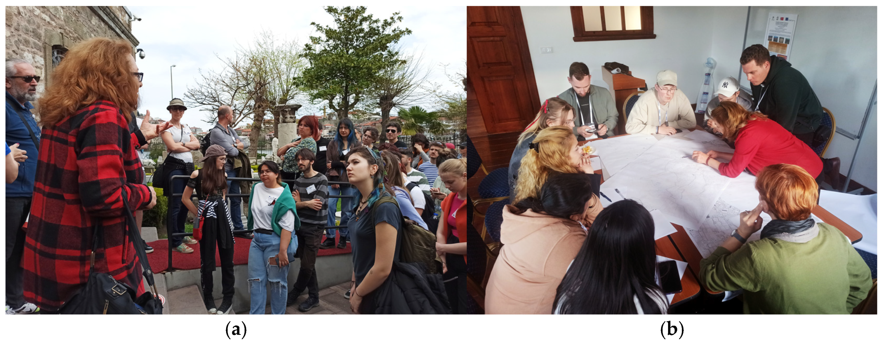
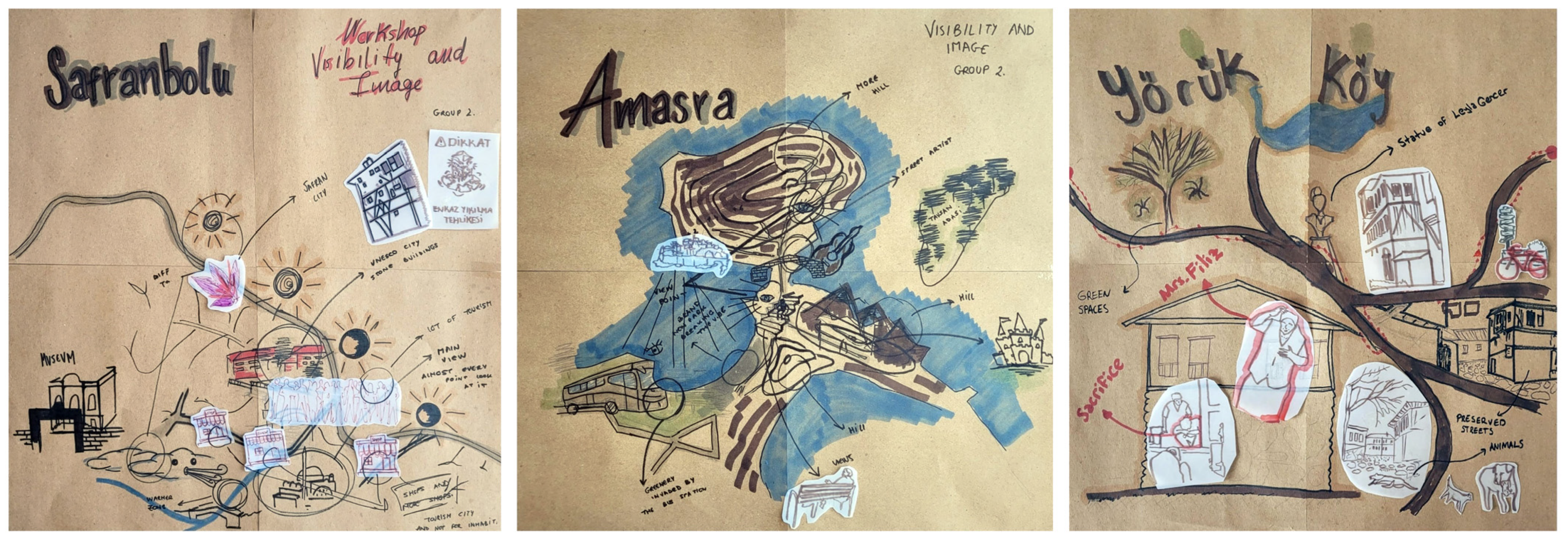
Two workshops were held in 2023–2024, covering Safranbolu, Amasra, Yörük, and Hadrianoupolis, with the participation of 79 students and faculty members from universities in Türkiye, Spain, Germany, Poland, Lithuania, Croatia, Romania, and Portugal. Eight working sub-groups addressed diverse, interconnected issues such as walkability, visual identity, and nature-based solutions by creating collective cartographies (Figure 5).

3. Research Area

3.1. Historical Background

The study area, located in the western part of the ancient region of Paphlagonia in Anatolia, features a wide distribution of cultural heritage remains from the Phrygian, Roman, and Genoese civilizations, including tumulus, rock-cut tombs, necropolises, churches, ancient settlements, and fortifications. The cities of Hadrianoupolis and Amastris were prominent centers in the region during the Roman period. Hadrianoupolis served as a significant commercial hub along regional trade routes, particularly during the Eastern Roman (Byzantine) period [67], while Amastris retained its importance as a port city due to its natural harbor [68].
During the Ottoman period, the cities of Safranbolu and Bartın emerged as two significant centers in the region. In the 17th century, Safranbolu became an important commercial hub on the Silk Road, linking Istanbul and the interior regions of Anatolia to the Black Sea coast and the city of Kastamonu. At the same time, Bartın, despite being located inland, leveraged the advantages of the Bartın River to develop into a center for shipbuilding and product export [69]. The flourishing trade and craftsmanship during this period also contributed to the region’s architectural enrichment [70].
Another element that enriched the region’s architecture was the presence of structures belonging to the Greek minority, who lived peacefully in various settlements until the 1923 population exchange between Türkiye and Greece [71]. In this context, the region’s cultural diversity and architectural richness provide valuable data for the study of its sociological structure and cultural heritage.

3.2. Heritage, Conservation and Tourism

3.2.1. Urban Areas

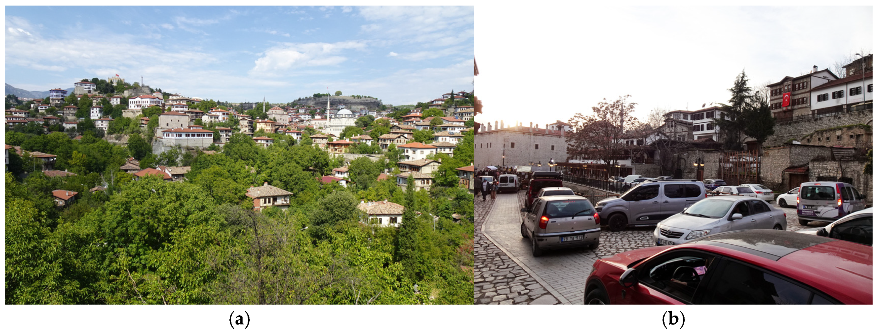
Since the 1970s, the collaboration between universities, the Ministry of Culture and Tourism, local authorities, and the community has significantly contributed to the preservation of cultural heritage in Safranbolu. The city was designated as an urban conservation area, comprising three sections: Çukur (the commercial center and Turkish quarters, Figure 6a), Kıranköy (the Greek quarter), and Bağlar (the area of summer residences) [46]. Safranbolu’s inclusion on the UNESCO World Heritage List in 1994 increased its national and international visibility, turning the city into a major tourist attraction. Initially, tourism investments had widely observed positive effects, particularly on the preservation of tangible cultural heritage.
However, subsequent reports prepared by the Turkish National Commission for UNESCO highlighted several issues arising from site management policies. These reports noted that tourism activities in Safranbolu have led to increased prices for essential goods and services, adversely affecting the lives of local residents, especially in the Çukur area. Negative impacts were observed on local trade, traditional crafts, transportation, and intangible cultural heritage, contributing to the displacement of local populations and narrowing the city’s functions to tourism-related activities (Figure 6b). Furthermore, concerns about profit-driven development have been reported to limit cultural heritage preservation efforts, exerting pressure on traditional architecture, particularly in the city’s peripheral areas [28,29]. The recent evaluation suggests that unplanned mass tourism activities may pose a more severe threat to the World Heritage Site in the future [27].
In the coastal town of Amasra, tourism activities can be traced back to the 1940s. The initial conservation efforts began in 1976 with the implementation of preservation regulations. However, despite these measures, including the 1988 Amasra Conservation Development Plan, conservation efforts have failed to prevent uncontrolled construction driven by mass tourism, resulting in the degradation of archaeological sites and civil architectural heritage [32,33] (Figure 7).
Beyond the impacts of urban development, natural areas have also suffered due to increased human activity. For example, the endemic sand lily (Pancratium maritimum), once thriving in Amasra’s dune ecosystems, has been eradicated due to intensive coastal tourism, and its habitat has become severely restricted in surrounding areas. Additionally, the expansion of mining and quarrying operations, the proliferation of unregulated landfill sites, and the planning of energy production facilities have further contributed to the destruction of the region’s natural heritage [34].
Amasra Fortress was added to the Tentative List of UNESCO World Heritage Sites in 2020 as part of the “Trading Posts and Fortifications on Genoese Trade Routes from the Mediterranean to the Black Sea” initiative, alongside sites in other countries [72]. While the city is home to 21 archaeological sites, scientific excavations began only after the fortress’s inclusion on the Tentative List. Despite this, there have been no significant efforts to establish a site management unit or to control mass tourism in the area. Furthermore, ongoing debates regarding Amasra’s urban conservation plan underscore the need for the development of sustainable preservation strategies [31].
In addition to Safranbolu and Amasra, two urban conservation areas are located in the provincial centers of Karabük and Bartın. In Karabük, the Yenişehir neighborhood, which contains the residential quarters of Türkiye’s first heavy industrial complex, holds this designation, while in Bartın, the city’s traditional commercial center is recognized as a conservation area [46]. However, the visibility of these sites remains largely confined to the local level, and both areas face significant preservation challenges.
Efforts to preserve intangible cultural heritage in urban areas have remained notably limited. Over time, traditional markets have lost much of their authenticity, and the production of traditional crafts and artisanal works persists only in a few workshops within historic city centers. Nevertheless, initiatives supported by various institutions—such as festivals centered on traditional products like saffron and grapes, city festivals, and certification programs for traditional artisans and artists—have contributed to the revitalization of intangible cultural heritage.

3.2.2. Rural Areas

Migration from rural areas in the region has accelerated since the late 20th century, driven by factors such as the inability of agricultural production to provide sufficient and stable income and limited access to essential services. Field research indicates that many rural settlements now have a significantly reduced permanent population, predominantly consisting of elderly individuals. While some villages still have a few households, the traditional settlements of such villages as Yürük (Üçevler), Kuzyakaöteköy, and Kayı have been completely abandoned. The majority of the remaining rural population consists of individuals over the age of 65, leading to a marked decline in agricultural activities. This reduction in rural production adversely affects both social and economic resilience.
The depopulation of rural areas also poses a serious threat to cultural heritage. Abandoned structures deteriorate due to neglect and exposure to natural elements, while those still in use are often improperly repaired due to insufficient financial support and a lack of awareness regarding proper preservation methods. Furthermore, archaeological sites in these depopulated areas are increasingly vulnerable to looting by treasure hunters and vandalism by uninformed or malicious individuals.
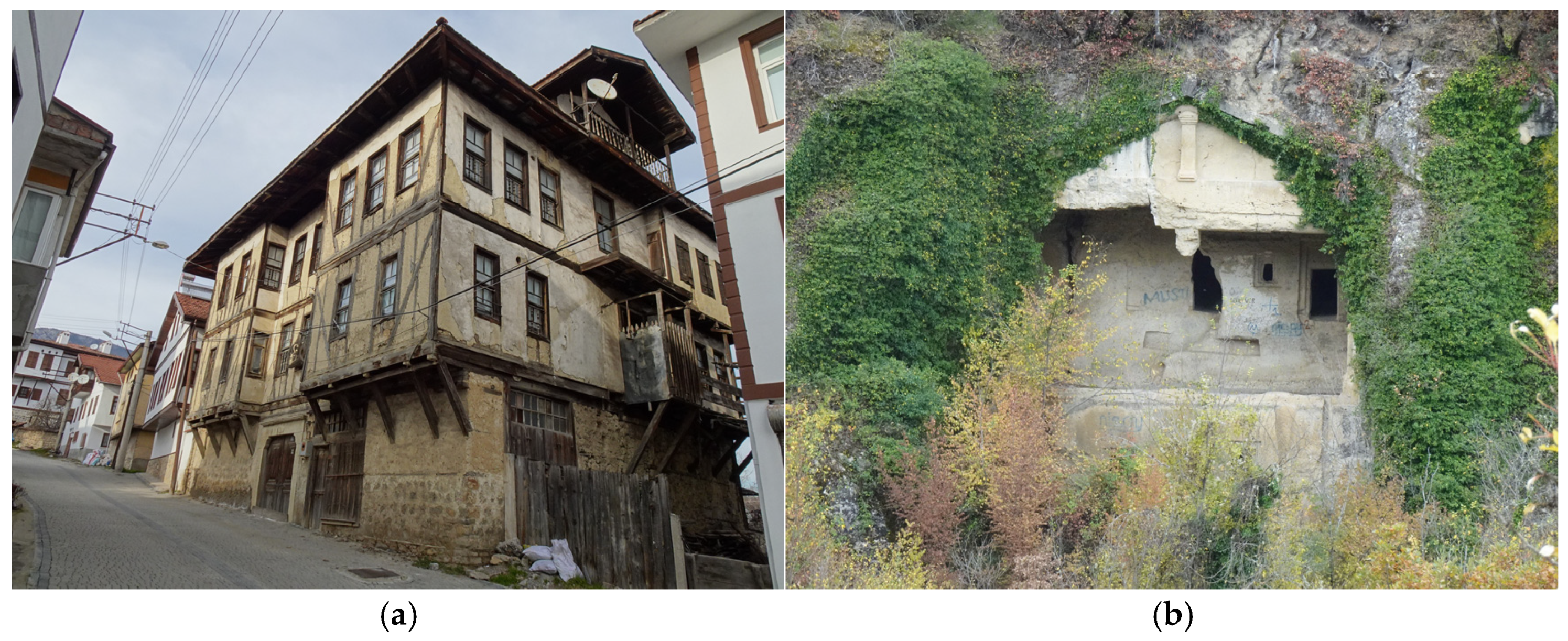
According to the Turkish Ministry of Culture and Tourism, there are 40 archaeological sites located in the rural areas within the study region. Thirteen of these sites are clustered around the settlements of Hacılarobası and Sallar, while the remaining sites are dispersed across various parts of the area. Hadrianoupolis Ancient City has recently been officially designated as an Open-Air Museum. The rural areas of the study region also contain Urban Conservation Areas, specifically in the villages of Yörük and Bulak [46] (Figure 8). Field studies have also revealed numerous sites that exhibit the characteristics of archaeological or urban conservation areas but have not yet received official designation. Examples include Yazıköy, Hacılarobası, and Ilbarıt (Üçbölük), which have retained their architectural integrity, as well as Toprakcuma, known for preserving its traditional commercial structures.
Karabük and Bartın are among Türkiye’s richest provinces in terms of natural heritage, encompassing vast forests, rivers, canyons, and rare geological formations (Figure 9). Karabük holds the highest proportion of forested land in Türkiye, with 73% of its territory covered by forests [73]. The Yenice Forests within Karabük are recognized as one of the “Hot Spots of European Forests” and are among the 100 most ecologically significant forest areas in Europe [74]. A large portion of these forests falls under the Yenice Wildlife Development Area designation. Within the study area, there are two Nature Parks near Bartın and Amasra; two Wildlife Development Areas near Susunduk and Yörük; seven designated Natural Sites in İmanlar, Karabük (Yenişehir), Safranbolu, Tayyip, Bartın, and Amasra; and one Registered Cave in Mencinis [47,58].
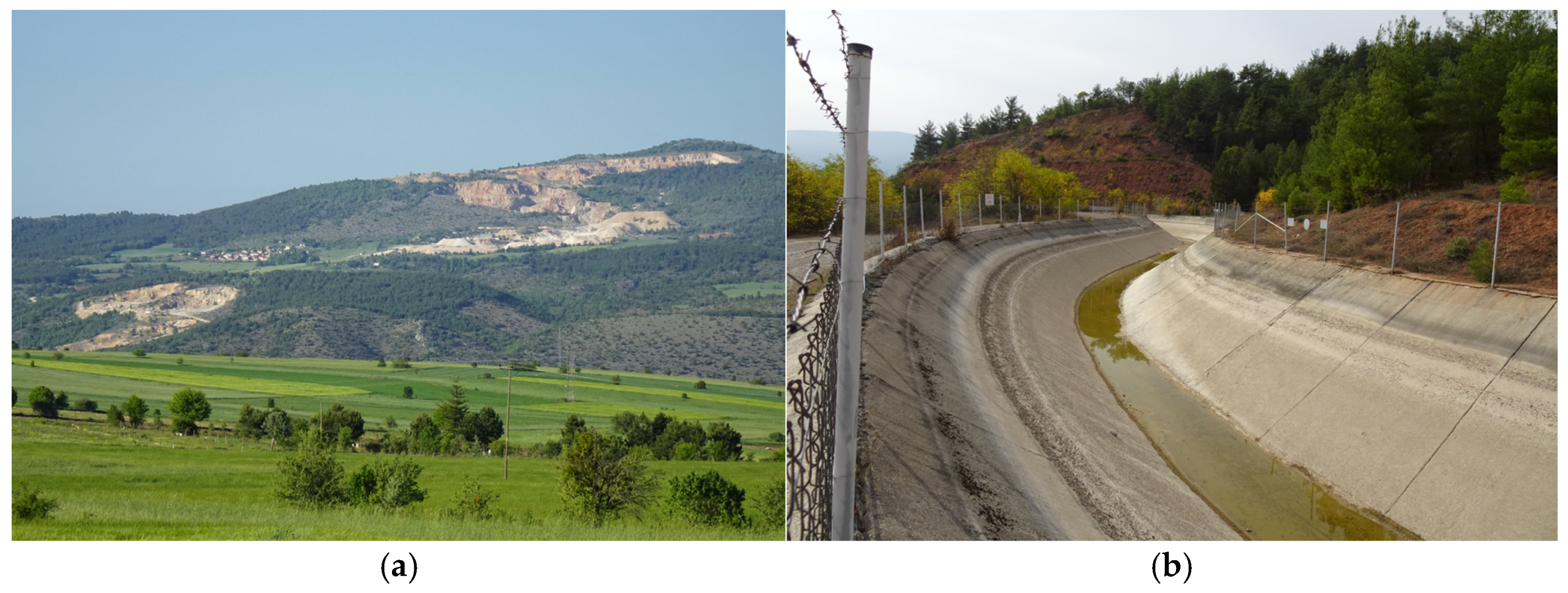
However, the exploitation of forests for raw materials poses a significant barrier to expanding protected areas. Additionally, rural depopulation has led to the abandonment of agricultural lands, prompting environmentally destructive practices—such as the establishment of hydroelectric power plants (HPPs), mining operations, and quarries—to extract short-term economic gains from these areas (Figure 10).
Among the rural settlements, Yörük Village emerges as a significant tourist destination due to its rich cultural heritage. Conservation efforts in the village are notably more organized and community-driven compared to other settlements in the region. In 2024, Yörük Village was included in the UNWTO Best Tourism Villages Upgrade Programme [75]. However, representatives from the local Cultural Heritage Preservation Association report that funding for the restoration of public buildings remains inadequate. Furthermore, the return migration of residents and the revival of rural production are insufficient to achieve sustainable long-term development in the village.
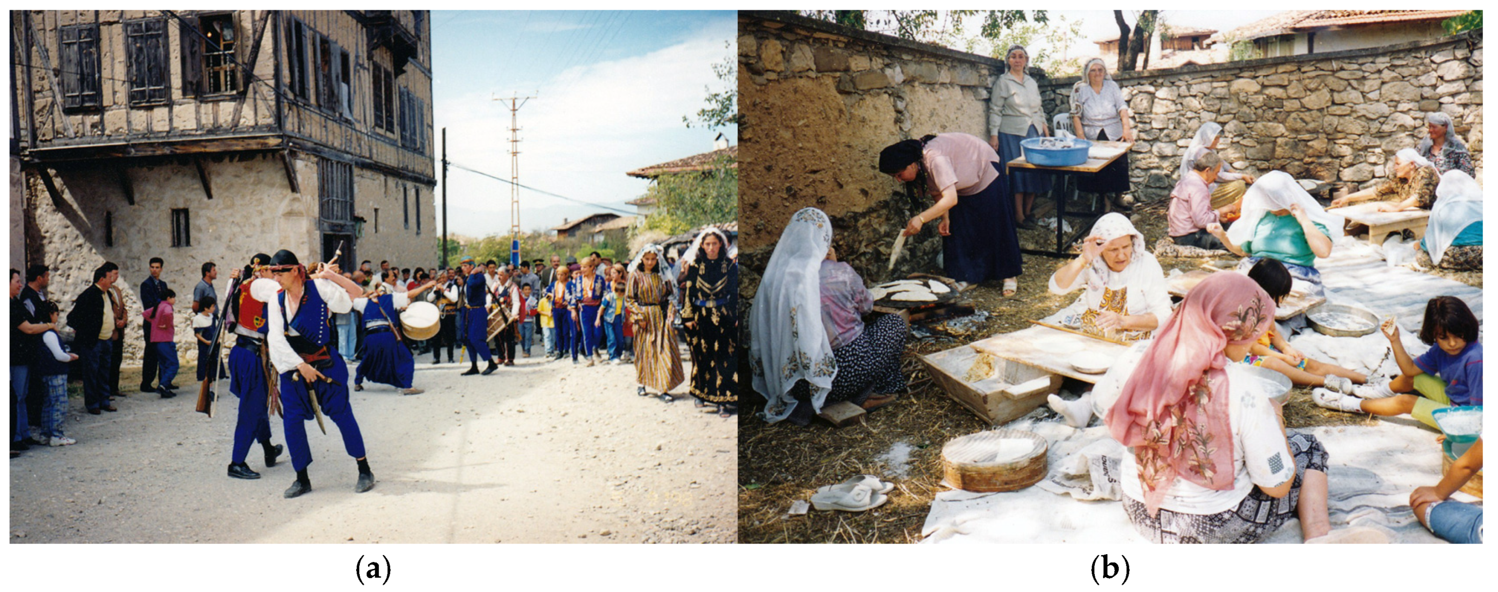
Markets and fairs in the villages have been discontinued, and workshops engaged in traditional production methods have ceased operations. However, prior to the COVID-19 pandemic, villages with strong sociocultural foundations, such as Yazıköy and Karapınar, continued to hold authentic celebrations of traditional festivals, including Bayram, Hıdrellez (spring festival), and special occasions like henna nights and weddings, which served as local attractions. In Yörük Village, Village Day events were organized to promote intangible cultural heritage (Figure 11). Despite these efforts, participation in such activities had been steadily declining since the early 2000s, and their scope was further diminished in the aftermath of the pandemic.

3.2.3. Regional Tourism Experiences

The Western Black Sea Tourism Master Plan, implemented in 2020 and encompassing the provinces of Karabük, Bartın, and Zonguldak, highlights the challenges of irregular urban development and infrastructure deficiencies resulting from the overconcentration of tourism activities in specific areas. The plan identifies the absence of integrated regional tourism strategies and the lack of spatial and temporal diversification in tourism activities as significant obstacles to achieving sustainable tourism. Similarly, the Cultural Tourism Focus Group Report by the Western Black Sea Development Agency (BAKKA) emphasizes the need to promote the region’s cultural and natural assets through a comprehensive and holistic approach [36]. Moreover, the 2024–2028 Western Black Sea Regional Plan outlines the development of tourism routes within various contexts [77].
Currently, these initiatives are being primarily advanced by relevant public institutions. In alignment with these objectives, several regional tourism routes have been proposed, including the Safranbolu-Eflani Mule Track, the Amastris and Kromna Route, and the Karaelmas Tourist Express. However, the implementation of the Safranbolu-Eflani and Amastris-Kromna routes has been hindered by inadequate infrastructure investments. The Karaelmas Tourist Express, launched in 2024 along the Ankara-Karabük-Zonguldak line, failed to meet expectations and was subsequently discontinued. The primary reasons for its failure included disagreements among stakeholders regarding stop locations and waiting times, as well as elevated ticket prices due to the inaugural trip coinciding with the peak tourism season.

3.2.4. Participatory Planning Experience

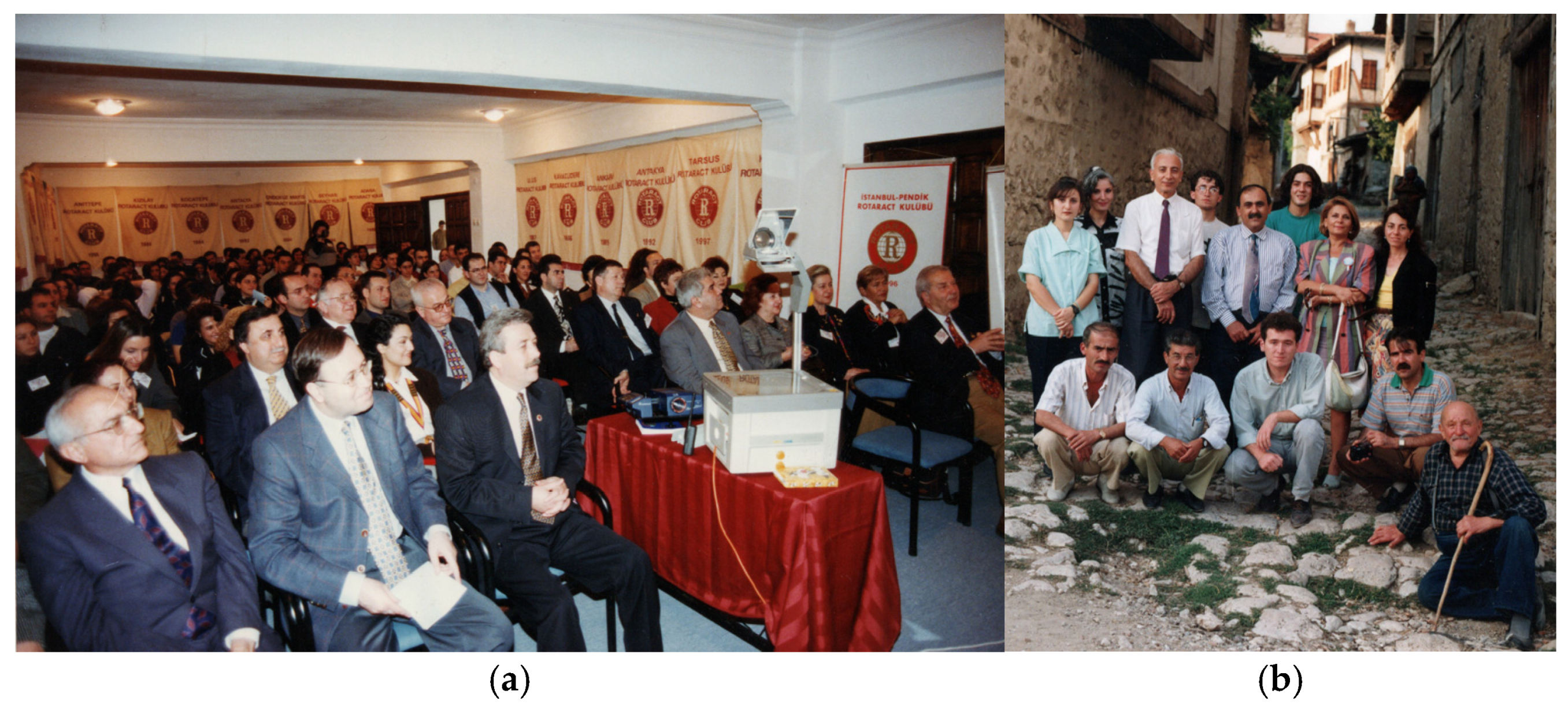
The initial steps toward the sustainability of cultural heritage in Safranbolu and the nearby Yörük village in the 1990s were spontaneous yet centered on “participatory tourism”. The key actors in this movement included local representatives of the Ministry of Culture and Tourism, local governments (governor’s office, municipality, village headman), academics, civil society organizations, and volunteer citizens. Over an extended period, this coalition, led by the governor’s office, developed and implemented various projects and activities with a shared objective. As a result, the conservation and restoration of cultural heritage were achieved, and a portion of the local population returned to the region. All stakeholders were actively involved at various stages, including awareness-raising, project development, and implementation. This participatory conservation movement was encapsulated by the slogan “if Safranbolu succeeds, Türkiye succeeds”, and it served as a model for other cities in Türkiye with cultural heritage sites (Figure 12).
In recent years, it has been observed that the policies pursued in the region have diverged from the philosophy of participatory conservation and development. The connections among local stakeholders have weakened, communication and coordination between local governments have diminished, and the supervisory roles in participatory initiatives have become less effective. Moreover, experts have had fewer opportunities to contribute to the policy development processes. Periodic reports and recommendations provided by UNESCO are often insufficiently considered. This situation has negatively impacted the conservation of cultural heritage and the development of sustainable tourism approaches in Safranbolu and the surrounding rural areas. Both the conservation and tourism experiences in the region, along with the findings from various studies conducted within the scope of this article, strongly highlight the significance of local residents, local businesses, and other stakeholders. Thus, it is confirmed that a solution that does not incorporate a participatory approach is not sustainable and viable.

4. Results

4.1. GIS Application

4.1.1. Spatial Mapping

The map generated using ArcMap 10.8 integrates identified historical traveler routes, analyzed sites, cultural and natural heritage conservation areas, public roads, and other relevant geographic data. A variety of open-source datasets were employed for elevation data [78], administrative boundaries, and settlement information [79], as well as data on public roads and water resources [80]. Information regarding conservation areas was obtained from officially declared protected area lists [46] and government GIS databases [47,58]. Figure A1 shows that the theme of historical travelers’ routes has a spatial pattern of conservation areas suitable for route tourism.
Cultural and natural heritage elements within the study area were documented through photographs and texts using a crowdsourcing approach. The collected materials were systematically categorized based on their attributes and subsequently uploaded to the Fulcrumapp platform for open use in further analysis and evaluation (https://web.fulcrumapp.com/shares/15956227ecc9e0c9?&popup_properties=status,label,administrative_units,type,detection_date,information,photo&title, accessed on 10 February 2025).

4.1.2. Rating of Sites

This study proposes a quantitative approach to assess the potential significance of destinations within the eco-cultural route. A total of 84 sites were evaluated using data from the attribute table in ArcGIS ArcMap 10.8 (Table S1). Each site was scored based on five indicators—TCH, ICH, NH, ABS, and CAC—according to the parameters outlined in Table 1. The raw scores for each indicator, along with their normalized values, are presented in Table A1.
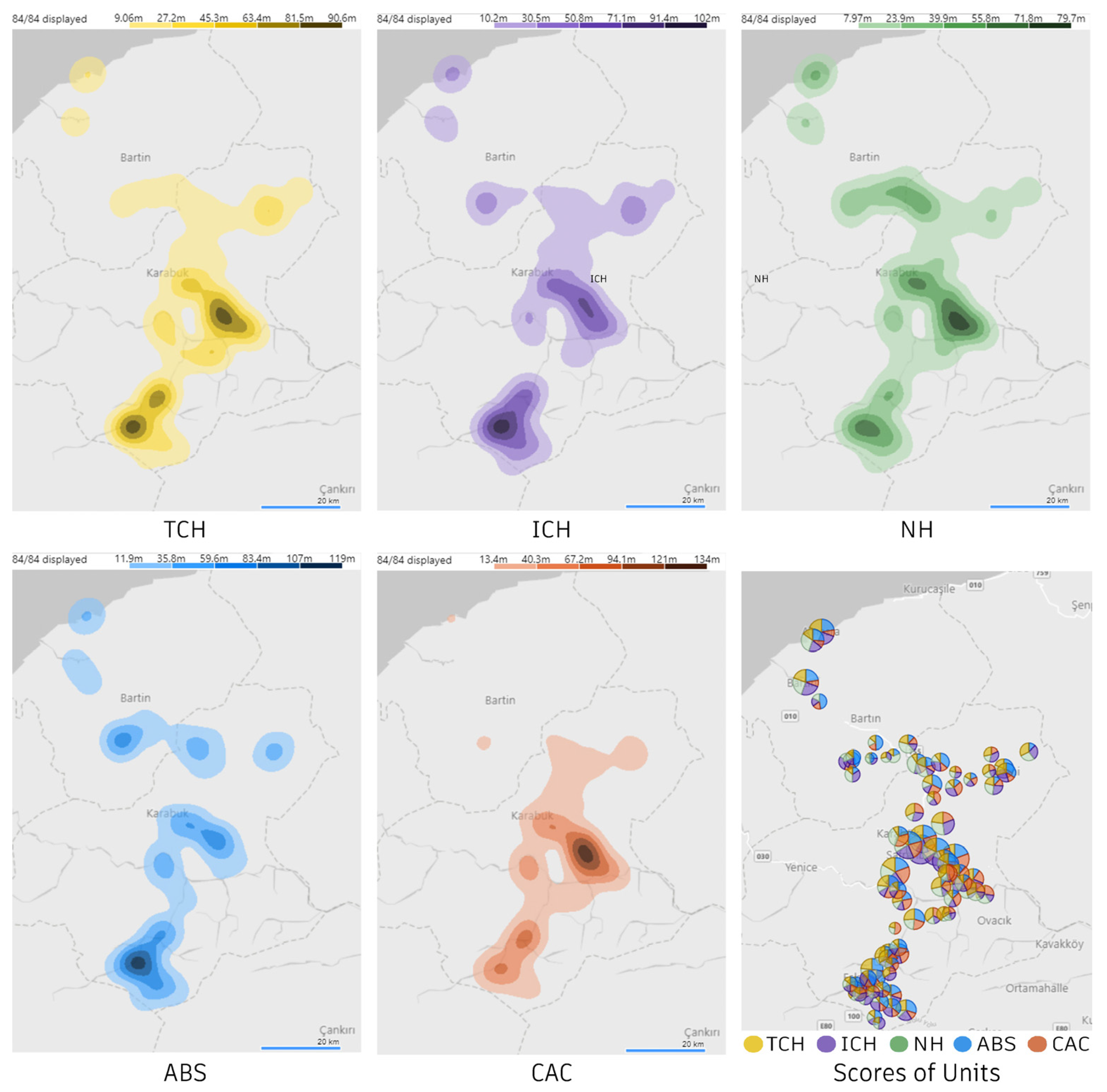
The indicator density maps derived from the normalized values are presented in Figure 13. The distribution patterns of TCH, ICH, and NH demonstrate significant similarities, while ABS and CAC exhibit distinct variations. These patterns are further analyzed in relation to the SOM findings in the following section.

4.2. AHP Application

To assign weights to the indicators (TCH, ICH, NH, ABS, and CAC), a survey utilizing pairwise comparisons was administered to 131 tourists in the centers of Safranbolu and Amasra. Participants were asked to evaluate each pair of indicators by selecting a value between 1 and 9, where 1 indicated equal importance of both indicators, and 9 signified extreme importance of one indicator over the other.
In both locations, an equal number of responses met the AHP consistency criteria. The geometric mean of 74 matrices was calculated to generate a single aggregated matrix. Following the standardized AHP computation procedures [59], indicator weightings and rankings are presented in Table 2.

4.3. Clustering Results

We employed Self-Organizing Map (SOM) analysis to generate routes based on the attributes of 84 sites. Weighted scores were calculated to determine the relative importance of each site (Table A1), and using AHP, five key indicators representing diverse tourist expectations were assessed (Table 2). These scores were then analyzed using SOM, which clustered the sites into groups based on underlying patterns and relationships, enabling a detailed evaluation of potential routes.
The clustering results, presented in Figure 14, reveal three distinct clusters, highlighting the distribution of 84 spatial sites across the indicators. These clusters demonstrate varying levels of site significance, with a specific emphasis on higher-scoring clusters (red and yellow area in the “Location of Sites”), which inform targeted strategies and optimize route planning. In the “Location of Sites”, the red cluster represents high potential sites, the yellow cluster corresponds to medium potential sites, and the blue cluster comprises low potential sites.
The SOM clustering reveals distinct spatial distribution patterns for each indicator. Heritage-based indicators (TCH, ICH, and NH) display significant spatial overlap, indicating a cohesive heritage landscape. In contrast, service- and connectivity-based indicators (ABS and CAC) exhibit fragmented and dispersed patterns, distinguishing them from the heritage indicators.
A comparative analysis of the protected areas’ distributions (Figure A1), indicators’ density (Figure 13), and clustering results (Figure 14) indicates that the spatial distribution patterns of the heritage values present considerable opportunities for the development of heritage-focused route tourism in the region. However, to effectively support tourism, ABS requires substantial infrastructure enhancements. Furthermore, improving the CAC indicator could involve introducing targeted attractions at specific points along the route to strengthen connectivity and enhance the overall visitor experience.

4.4. Proposal for the Eco-Cultural Route

The proposed eco-cultural route prioritizes the conservation of natural and cultural heritage sites and the minimization of environmental impact. To achieve this, the entire route follows existing roads, eliminating the need for new infrastructure development. As illustrated in Figure 14 (“Location of Sites” map), the route connects settlements classified as having high and medium potential. The route design focuses on maintaining short travel distances between settlements, ensuring high travel comfort, and maximizing exposure to heritage sites along the way. Where feasible, the route integrates authentic historical roads and historic bridges to enhance cultural authenticity. To avoid increasing environmental impact and potential legal complications, the route avoids traversing Wildlife Development Areas and Nature Reserves. Figure 15 presents the proposed eco-cultural route and the associated heritage sites located throughout the route.
The designated routes are classified based on their difficulty and comfort levels.
  • Group A: Routes accessible by public transportation, offering the highest level of comfort.
  • Group B: Routes suitable for wheeled eco-vehicles, providing a moderate level of comfort, higher than Groups C and D.
  • Group C: Routes consisting primarily of unpaved or deteriorated roads, generally unsuitable for eco-vehicles.
  • Group D: Routes where the use of vehicles is not recommended, designed specifically for trekking. These paths offer scenic vistas and natural landscapes, enhancing the traveler’s experience.

4.5. SWOT Analysis

An in-depth analysis of the proposed eco-cultural route was conducted using a SWOT analysis. The factors in the SWOT analysis are organized under headings and ranked in tables based on the frequency of mentions by participants. The specific areas where participants primarily associated these factors are depicted in Figure S1. To ensure clarity and ease of interpretation, each participant and factor was assigned a unique identifier (ID) in both the maps and tables.

4.5.1. Strengths

A substantial number of participants concurred on the strengths of the region’s natural, archaeological, and architectural heritage. The emphasis on religious heritage, cultural diversity, historical narratives, authentic products, and gastronomic heritage indicates a strong potential for developing alternative tourism strategies centered on intangible cultural heritage. Furthermore, the continued enhancement of tourism infrastructure and facilities to support alternative tourism, the presence of diverse accommodation options, and the organization of festivals and related cultural events contribute to the advancement of eco-tourism in the region (Table S2).

4.5.2. Weaknesses

The analysis reveals significant management challenges related to both conservation and tourism. Key issues include the absence of effective site management mechanisms, a lack of integrated strategies, and limited adoption of participatory approaches. Furthermore, the insufficient involvement of citizens and lack of transparency in policy-making, coupled with political conflicts among stakeholders, were identified as major weaknesses hindering the implementation of participatory management frameworks.
Several factors have been identified as contributing to the deterioration risks of heritage sites, including excessive traffic, irregular and unauthorized construction, industrial pollution, faulty restoration practices, migration, and property ownership challenges (e.g., public buildings under private ownership and fragmented landholdings). Additionally, the lack of awareness among local communities and insufficient funding for conservation and restoration efforts further exacerbate these risks.
Participants also highlighted weaknesses in the management of tourism revenues, the promotion of heritage sites, and the quality control of services and products. In particular, there are significant deficiencies in tourism infrastructure, particularly in rural areas. For example, despite efforts to promote the necropolis sites in the Soğanlı River Valley within Karabük Province, no infrastructure has been developed to support tourism activities in the region (Table S3).

4.5.3. Opportunities

Participants underscored the importance of engaging with international recognition and certification programs such as the UNESCO World Heritage List (Safranbolu), the UNESCO World Heritage Tentative List (Amasra Fortress), the UNWTO Best Tourism Villages Upgrade Programme (Yörük Village), PAN Parks (Küre Mountains National Park), and Cittaslow (Safranbolu). It is widely believed that active participation in these initiatives contributes significantly to both the region’s global visibility and the enhancement of heritage conservation standards. Particular emphasis was placed on the inclusion of Amasra in the UNESCO World Heritage List, which was identified as a critical objective for both the region and the proposed eco-cultural route.
The region’s proximity to major metropolitan centers, such as Ankara and Istanbul, combined with the availability of alternative transportation—including railways, maritime routes, and historic pathways—was identified as a significant opportunity for tourism development. Notably, participants positively rated initiatives to enhance maritime tourism, which was recognized for its high revenue potential.
Ongoing archaeological excavations in the ancient cities of Amastris (Amasra) and Hadrianoupolis, along with the continuous discovery of new findings, were highlighted as contributing not only to academic knowledge but also to the promotion of the region. The importance of supporting similar scientific research in other cultural and natural heritage sites was also emphasized as a key opportunity (Table S4).

4.5.4. Threats

Participants identified several critical threats to cultural heritage sites, including construction pressures driven by economic interests, the reduction of protected areas, and the proximity of planned mining, energy, and industrial facilities to heritage sites. Seismic activity was also highlighted as a significant risk factor. Both cultural and natural heritage sites are increasingly vulnerable to climate change-related threats, such as wildfires, flooding, and droughts. Additionally, damage caused by treasure hunters and vandals in cultural heritage areas, along with illegal hunting, harvesting, and biological trafficking in natural heritage sites, were identified as pressing concerns that require mitigation through awareness campaigns and regulatory enforcement.
Concerns regarding the environmental, social, and economic impacts of tourism were prominently highlighted. Specifically, the adverse effects on local lifestyles and the overexploitation of natural resources emphasize the necessity for developing a sustainable tourism model.
Participants expressed concerns over the limited scope of legal protection zones, the absence of buffer areas, and inadequate oversight of projects within protected sites. These concerns are exemplified by two recent cases: In Bulak Village, within a designated site in Karabük, the original cobblestone pavements were entirely removed and replaced with new materials under the pretext of improving road comfort, compromising the integrity of the heritage fabric. Similarly, in Bartın, excessive modifications made along the Bartın River as part of a flood prevention project have resulted in the degradation of the natural landscape (Table S5).

4.6. Charrettes

The charrettes marked the final phase of the study, where preliminary findings were critically analyzed and expanded through an interdisciplinary approach. These workshops enabled in-depth discussions of the SWOT analysis results and the potential impacts of the proposed eco-cultural route, promoting collaborative evaluation and refinement of planning strategies. Collective and interdisciplinary perspectives emerged during the Erasmus+ workshops—featuring site excursions, sub-group co-creations (Figure 16), concluding presentations, and deliberations—emphasizing key themes such as cultural and natural heritage, transportation and routes, local communities, inclusivity, capacity building, circularity, and crafts.
In the urban centers of Safranbolu and Amasra, the groups’ discussions highlighted the detrimental impacts of unsustainable human activities—such as over-tourism, excessive traffic, and intensified commercial operations—on cultural heritage sites and coastal zones. The adverse effects of uncontrolled urban sprawl, rapid and dense construction, and inappropriate interventions were also identified as critical threats to heritage preservation. Conversely, in Yörük Village and other rural areas, attention was drawn to the declining local population, insufficient conservation planning, and the absence of effective preservation measures.
One participant identified the primary factor threatening the sustainability of heritage as “environmental, social, and economic management that lacks the involvement of local communities and stakeholders”. The participant further argued that “a participatory approach will be effective if all stakeholders are adequately informed about the potential outcomes of strategies and implementations. Therefore, participation must be as broad and democratic as possible”.
Another participant outlined the necessary measures for ensuring the sustainability of heritage sites as follows: “It is essential to retain local communities within their places of origin and traditional cycles. By doing so, local populations can sustain heritage both materially and spiritually. In the context of the built environment, we have observed a significant disparity between structures that are inhabited and those that are not. Specifically, in Yörük Village, the local community emphasized the critical role of residents in the maintenance of buildings. Cultural heritage is inherently fragile and is sustained through the presence of those who inhabit it. These individuals possess knowledge of their homes’ histories, construction methods, and unique attributes. In my view, this intimate connection is what constitutes cultural heritage”.
The key outcomes of the two interconnected charrettes emphasize the following strategic recommendations:
  • Integration of Cultural and Natural Heritage Sites: Establishing eco-cultural routes that link cultural and natural heritage areas to promote comprehensive and diverse visitor experiences.
  • Community Participation: Developing mechanisms that facilitate the active and effective involvement of local communities in regional and local planning processes while ensuring transparency as a core principle for institutional practice.
  • Regulation of Transportation: Differentiating between motor vehicle roads, eco-friendly transport routes, and pedestrian pathways to mitigate traffic congestion and carbon emissions while promoting walkable environments.
  • Accessibility: Implementing inclusive principles and infrastructure to create a barrier-free environment, ensuring accessibility for all individuals.
  • Enhancement of Infrastructure: Expanding and improving critical infrastructure and public services to better accommodate the needs and expectations of both locals and tourists. Most notably, prioritizing nature-based solutions and resilience for the climate crisis, including the rehabilitation of green corridors and coastal ecotonal areas, is vital.
  • Advancement of Conservation and Promotion Efforts: Developing innovative and robust methods for the protection and presentation of heritage sites to ensure their preservation while fostering collaboration with various stakeholders.
These collectively identified principles and discussions highlight the essential dimensions required to plan an eco-cultural route that is feasible, sustainable, and viable. While the primary outcome of the study may appear to be the route proposal, these collective processes are of critical importance and are indispensable for future progress. To ensure continued development, it is necessary to diversify participants and expand the scope of involvement.

5. Discussion

This section examines the following critical dimensions in the context of the findings and existing paradigms in the literature: (1) the sustainable conservation of heritage and the management of heritage sites, (2) the role of tourism in sustainable conservation and development, and (3) the evaluation of the proposed integrated approach.

5.1. Heritage Dimension

The need to manage a range of issues within the extensive area, including tangible and intangible cultural heritage, natural heritage, the negative impacts of mass tourism, and rural depopulation, presents complex, multi-dimensional challenges.
SWOT analyses reveal that factors perceived as threats by some participants can be seen as opportunities by others, underscoring the controversies surrounding the heritage dimension. In our study, we included the diverse perspectives of local residents, organizations, and experts on the future of the region. These perspectives collectively shape ‘the common’ both in physical (streets, squares, community gardens) and conceptual (norms, laws, bureaucracy) terms [81]. Sennett [82] argues that when the practical and institutional spheres are disconnected, both lose their potential. Therefore, a heritage-driven approach should integrate and enhance both domains to promote the emancipation of citizenship and long-term sustainability.
The study reveals that lack of coordination and collaboration among various stakeholders and institutions in the protection of cultural and natural heritage are one of the primary obstacles to the development of sustainable conservation actions. It has been observed that, in many cases, management plans can mitigate such challenges [83]. However, there is currently no active area management plan within the study area or any of its sub-areas. Although, as Bozkurt suggests [84], area management units in Türkiye often function more like civil society organizations—coordinating relevant authorities, collecting statistics, and preparing reports—rather than acting as effective public authorities, the establishment of area management units and plans is crucial. Sokka et al. [85] also highlight that the success of heritage management processes is without substantial participation of local communities in processes such as goal setting and strategy development. To achieve genuine participation for heritage preservation, reverse migration to rural areas should be supported in the region.
The studies by MacDonald et al. [86] and Zhang et al. [87] indicate that the primary cause of rural depopulation, particularly in mountain villages across various regions, is insufficient economic income. Interviews conducted for this study revealed that local residents, especially in mountain villages, pointed to agricultural disadvantages due to the terrain, the transformation of much of the land into forests after prolonged periods of abandonment, and the lack of subsidies for agricultural products. This study suggests that ecotourism could present a significant opportunity for sites identified as having “high potential” and “medium potential” (Figure 15). If supported through a multi-dimensional approach, ecotourism could help mitigate depopulation and contribute to sustainable conservation and development.

5.2. Tourism Dimension

The perception of nature as an infinite resource has resulted in unchecked exploitation, ignoring biophysical limits [88,89]. Mounting evidence of environmental degradation underscores the urgency of recognizing these limits to growth [90]. Lefebvre highlights the tension between the right to nature and the right to the city [91]. Integrating heritage conservation with contemporary degrowth and post-growth perspectives, informed by an eco-social framework, it seeks to promote sustainable and just nature-based solutions [92,93].
Balancing conservation and tourism activities in vulnerable heritage sites is one of the most crucial factors for ensuring the sustainability [94]. The primary factor influencing the policies to be adopted in achieving this fundamental objective is identifying which tourism approaches are most suitable for the region.
The literature on heritage sites presents two main perspectives regarding the term “mass tourism”. Some studies focus on the detrimental impacts of mass tourism on the environment, heritage sites, and local communities [95,96], while others argue that mass tourism can be planned sustainably [97,98]. For instance, Peeters emphasizes that rather than developing alternative tourism approaches for sustainability, the focus should be on making mass tourism destinations sustainable [99]. Hernandez, on the other hand, suggests that the success of rural tourism destinations can be positively influenced by mass tourism destinations [100].
Before tourism activities began in Safranbolu, the city largely appeared abandoned. The 1990s, a period when tourism began to dominate cultural heritage sites worldwide, coincided with the development of tourism in the city [101]. During this time, mass tourism policies were viewed as the most effective means of preserving cultural heritage. As a result, the city’s previously abandoned appearance changed rapidly, and with the return of the local population, steps were taken to preserve both tangible and intangible cultural heritage.
In Amasra, tourism began with camping activities in the 1940s and expanded rapidly after the 1960s. Despite the city’s rich cultural heritage, cultural heritage has never been a central focus of the tourism activities carried out. Consequently, for an extended period, tourism activities and cultural heritage sites in Amasra have represented two conflicting aspects [31,34]. Therefore, addressing these two cities together is one of the promising aspects of this study.
Today, both centers are subject to serious criticism regarding tourism approaches and practices. It is evident that adopting a holistic and participatory approach to evaluating the region is crucial for the sustainability of heritage conservation, tourism, development, and the well-being of the local community. Drawing on lessons from the pandemic and, more broadly, the climate crisis, the need for long-term ecosocial approaches was emphasized. Ecocentric approaches, in particular, propose a more democratic paradigm shift by advocating for the inclusion of nature’s rights in decision-making processes, especially concerning the commercialization, appropriation, exploitation, and privatization of vulnerable ecological urban and rural areas.

5.3. Methodological Reflection

This study adopts a mixed-methods approach to examine the complex socio-spatial dynamics within the research area. Integrating diverse analytical tools and frameworks offers a holistic perspective to address multifaceted challenges. The collaborative engagement of students played a pivotal role in sustaining extensive fieldwork across the rural region. The incorporation of a crowdsourcing digital participatory platform (DPP) effectively streamlined synchronous and asynchronous data collection, significantly improving efficiency. Furthermore, leveraging this platform in university–public collaborations proved instrumental in identifying and formally registering structures requiring recognition and protection. Unlike technocratic planning support systems, DPPs foster collaboration, empowering people in decision-making, reporting, and co-creation [102].
The selection of indicators and parameters for AHP and unit ratings directly shaped the quantitative outcomes. Adjustments to AHP weightings and the inclusion of new parameters can further refine the SOM-generated route clusters to reflect evolving priorities. AHP’s application to assess tourists’ expectations and perceptions yielded reliable and consistent findings, facilitating data integration into route planning. Future research will extend AHP surveys to encompass diverse stakeholders, enabling comparative analyses based on variables such as tourist profiles and local versus international preferences.
The comprehensive datasets, shared as open-access resources in Supplementary Materials, provide a foundation for further research and the development of conservation and tourism applications. The study framework is adaptable, allowing variations in themes, locations, and indicators to spark new inquiries. Given the interdisciplinary nature of the topic, further research across economic, sociological, ecological, cultural, and architectural domains is essential. Establishing interactive platforms for stakeholder dialogue is required to strengthen implementation strategies.
Ultimately, our methodology serves as a living laboratory, continuously assessing site-specific dynamics and promoting sustainable eco-cultural development. Future iterations will expand interdisciplinary perspectives and active participation through onsite and digital platforms, enhancing inclusivity and collaboration. Continuous input from local stakeholders and experts, alongside follow-up mechanisms, will support ongoing refinements to ecological, social, and economic dimensions, maintaining relevance and effectiveness over time.
The novel and flexible methodology introduced in this study offers a data-driven and inclusive tourism route planning strategy, presenting a replicable model for other regions facing similar challenges. Designed to support a participatory approach, the methodology provides a holistic framework that strengthens decision-making processes in conservation and tourism planning.

6. Conclusions and Recommendations

This study proposes a participatory approach to develop an eco-cultural route that promotes sustainable conservation, development, and the well-being of local communities in 84 heritage sites affected by urban mass tourism or rural depopulation. The key findings highlight the potential of historical travelers’ routes to link the region’s cultural and natural heritage sites with sustainable tourism strategies. Moreover, the study reveals significant potential and risks for eco-cultural tourism development in the region, particularly by connecting less-visited rural areas to established destinations such as Safranbolu and Amasra.
Within the scope of the study, tourist trends in the area have been evaluated. The integrated assessment of TCH, ICH, and NH promotes sustainable tourism. However, shortcomings, challenges, and management issues highlight the need for capacity building and policy interventions to support ecotourism development.
According to AHP results, the relatively high priorities of the NH (29%) and TCH (25%) indicators, along with the lower priorities of the CAC (18%) and ABS (14%) indicators, indicate that heritage tourism is supported despite issues related to the spatial distribution of attraction centers, as well as deficiencies in services, transportation, and tourism infrastructure. Meanwhile, the value of the ICH (14%) indicator highlights the necessity of improvement and promotion actions for intangible heritage in the region.
In addition to the 28 high-potential sites, 20 medium-potential sites have been included to enhance the geographical and social inclusivity of the eco-cultural route. Evaluations and recommendations regarding the proposed route and sites are provided below.
  • The existing tourism dynamics support the potential success of the route. According to 2024 statistics, approximately 2,600,000 people (including daily visitors) visit Safranbolu annually [103], while Amasra receives around 2,500,000 visitors (including daily visitors) annually [104]. These figures can be associated with the potential demand for the final product. However, beyond the quantity of tourists, their expectations, socio-economic status, and diversity are crucial for the proper functioning of the route. At the international level, Amasra’s heavy reliance on cruise tourism—particularly with a large proportion of Russian tourists—and Safranbolu’s dependency on visitors mainly from China, Taiwan, and Thailand contribute to a limited tourist profile. This lack of diversity increases the vulnerability of the tourism sector in both destinations.
  • Among the high-potential sites, the following are recommended as priorities during the initial implementation phase to support the development of surrounding areas: (1) Safranbolu, Amasra, and the nearby sites (Yazıköy, Bulak, Kirkille, and Gömü), (2) the sites located together in the Soğanlı Stream Valley, featuring archaeological heritage and traditional architecture (Hacılarobası, Ilbarıt, Karakoyunlu, Bürnük, Hocaoğlu K., Çavuşlar, Bağlıca, and Sallar), and (3) the two provincial centers, Karabük and Bartın.
  • Many successful examples have recognized the “cultural route” as a method for preserving and maintaining cultural heritage. However, numerous initiatives have failed due to prioritizing high revenue generation in the short and medium term [105]. Therefore, in the initial stages of implementation, the eco-cultural route must be subsidized by international, national, and local non-profit organizations. Moreover, for long-term economic sustainability, it is essential to gradually increase the financial contributions of cooperatives (including producers and businesses), local community associations, and private sponsors to the central budget.
  • Ensuring income diversification is crucial for sustainable development and socio-economic resilience. Tourism revenues alone may not be sufficient to achieve sustainability in sensitive areas that require protection. In this case, “multiple-use management” is recommended [106]. Therefore, developing multiple uses (such as agriculture, livestock, and crafts) that align with the identities of the sites is important. Such regional planning requires interdisciplinary efforts.
  • To highlight cultural heritage, we recommend removing structures that damage tangible cultural heritage and disrupt the skyline. Sites that have not yet been protected at the building scale should be urgently safeguarded, and restoration and infrastructure work should be carried out. In this regard, sites such as Amasra Castle and the Yenişehir in Karabük (industrial heritage) should be prioritized. In line with the eco-cultural route context, particularly in rural areas, abandoned caravanserais, hammams, historical bazaars, and mansions should be restored and repurposed for tourism and other services.
  • The expansion of the ecological conservation cases exemplified within the research area is crucial for the preservation of natural heritage, particularly through increased local awareness. Interventions that promote eco-social transition—such as erosion and flood prevention, protection of endemic species, and restoration of habitat diversity—should be adopted and implemented by regional and local authorities. Mining, quarry activities, and unplanned construction should be prevented within the area, and restoration projects for natural areas should be carried out.
  • The proposed route prioritizes roads that require minimal intervention to reduce environmental impact and address geographic and economic challenges. Alternatives exist for less suitable roads. However, improving public transportation and adapting roads for eco-friendly vehicles is essential. In particular, access to İmanlar, Derecami, and Karapınar should be enhanced. To reduce conflicts among different user groups, roads should also be separated based on user types, and appropriate safety measures should be implemented.
  • Especially in sensitive areas where natural and cultural heritage intersect, initiatives that integrate social structures with heritage must be consciously sustained over the long term to ensure success [107]. In the regional dynamics, the efforts that began in the 1970s in Safranbolu and the Yörük village only started to yield positive results toward the 2000s. Therefore, to minimize the potential negative impacts of interventions on the local population and heritage sites (such as degradation, gentrification, migration, unplanned construction, the complete abandonment of traditional production methods), planning must be extended over the long term and periodically reviewed.
  • Seven main stages, which must be carried out in coordination, are proposed to ensure the successful implementation of the project: (1) establishing the central budget with contributions from non-profit organizations, (2) conducting awareness-raising activities and developing protection and restoration activities for heritage sites, as well as regulatory activities for tourism areas, (3) implementing measures to enhance road safety and accessibility while supporting ecological transportation methods, (4) supporting the return of the local population and increasing local production through social and economic incentives, (5) developing tourism, production, and infrastructure facilities with an approach that aligns with the characteristics of the sites and the theme of the route, (6) encouraging participation in networks that support ecotourism and conducting promotional activities, and (7) gradually increasing the contributions of cooperatives, local community associations, and sponsors to the central budget, ensuring economic sustainability.
  • The study area consists of sub-regions with distinct characteristics. To develop a sustainable conservation and tourism approach, including eco-cultural routes, it is essential to adopt a holistic planning process that considers these unique attributes and encourages collaboration. These efforts, similarly to past experiences in the region, will drive responsible and robust policy implementation as well as future systemic impacts. In Safranbolu, steps can be taken to enhance the sustainability of tourism activities by prioritizing conservation and educational efforts while also integrating natural heritage areas into planning. In Amasra, which has advantages in tourism diversity and potential activities, ecological solutions should include supporting alternative tourism, reducing coastal tourism pressure, mitigating seasonality effects, and focusing on the sustainability of cultural and natural heritage. For rural areas, projects should promote local tourism products through sustainable certification programs and business networks, emphasizing circular and ecological approaches. Considering both regional and global crises, the proposed strategy is expected to be implemented with truly participatory, sustainable, fair, and circular economy practices.

Supplementary Materials

The following supporting information can be downloaded at: https://www.mdpi.com/article/10.3390/su17073157/s1, Table S1: The attribute table that forms the basis for site rating; Figure S1: Distribution of SWOT factors; Table S2: The strength factors of SWOT analysis; Table S3: The weakness factors of SWOT analysis; Table S4: The opportunity factors of SWOT analysis; Table S5: The threat factors of SWOT analysis.

Author Contributions

Conceptualization, E.K.; methodology, E.K. and M.A.H.; software, E.K. and M.A.H.; validation, E.K. and A.Ö.; formal analysis, E.K., A.Ö. and M.A.H.; investigation, E.K., A.Ö. and M.A.H.; resources, E.K. and M.A.H.; data curation, E.K., A.Ö. and M.A.H.; writing—original draft preparation, E.K.; writing—review and editing, E.K.; visualization, E.K. and M.A.H.; supervision, A.Ö.; project administration, E.K. and M.A.H.; funding acquisition, E.K., A.Ö. and M.A.H. All authors have read and agreed to the published version of the manuscript.

Funding

This research received no external funding.

Institutional Review Board Statement

The study was conducted in accordance with the Declaration of Helsinki, and this study was approved by the Karabük University Ethics Committee for Social and Human Sciences Research (2023/04-30, 18 May 2023).

Informed Consent Statement

Informed consent was obtained from all subjects involved in the study.

Data Availability Statement

Original data will be provided in dialogue with the authors to ensure the safety and anonymity of the people present in the recordings and transcriptions.

Acknowledgments

(a) This paper is based on Emre Karataş’s ongoing doctoral research conducted under the supervision of Aysun Özköse in the Architecture Program of Karabük University. (b) In Figure 15, the documented heritage assets in the area have been visualized using an artificial intelligence drawing assistance application (https://www.samsung.com/ae/support/mobile-devices/how-to-use-sketch-to-image-feature-with-s-pen-ai-suggestions/, accessed on 6 January 2025). (c) ChatGPT-4 was used to make suggestions on English grammar corrections and paraphrasing (https://openai.com/, accessed on 26 January 2025). (d) We extend our gratitude to the participants who contributed significantly to research.

Conflicts of Interest

The authors declare no conflicts of interest.

Appendix A

Figure A1. The map of research area and historical traveler routes.
Sustainability 17 03157 g0a1

Appendix B

Table A1. Ratings of indicators and their normalized values.
ID DistrictSiteTCH
Rating
(Norm.)
ICH
Rating
(Norm.)
NH
Rating
(Norm.)
ABS
Rating
(Norm.)
CAC
Rating
(Norm.)
1 Eflani3 (1.89)2 (1.60)0 (0.00)3 (2.17)1 (0.80)
2 Konak2 (1.26)1 (0.80)1 (0.81)0 (0.00)1 (0.80)
3 Bedil2 (1.26)2 (1.60)1 (0.81)0 (0.00)1 (0.80)
4EflaniÇelebiler2 (1.26)2 (1.60)1 (0.81)3 (2.17)1 (0.80)
5 Esencik3 (1.89)2 (1.60)2 (1.63)1 (0.72)0 (0.00)
6 Kocacık1 (0.63)1 (0.80)1 (0.81)1 (0.72)1 (0.80)
7 Ulugeçit2 (1.26)2 (1.60)2 (1.63)1 (0.72)1 (0.80)
8 Eskipazar1 (0.63)2 (1.60)0 (0.00)3 (2.17)1 (0.80)
9 Arslanlar0 (0.00)2 (1.60)1 (0.81)3 (2.17)1 (0.80)
10 Bayındır1 (0.63)2 (1.60)1 (0.81)3 (2.17)1 (0.80)
11 Beytarla1 (0.63)2 (1.60)1 (0.81)0 (0.00)1 (0.80)
12 Çekişler3 (1.89)2 (1.60)1 (0.81)0 (0.00)1 (0.80)
13 Hadrianoupolis3 (1.89)1 (0.80)1 (0.81)2 (1.45)1 (0.80)
14 Bulduk1 (0.63)2 (1.60)1 (0.81)0 (0.00)0 (0.00)
15 Büyükyayalar1 (0.63)1 (0.80)1 (0.81)2 (1.45)1 (0.80)
16 Çaylı1 (0.63)1 (0.80)1 (0.81)2 (1.45)1 (0.80)
17 Deresemail1 (0.63)1 (0.80)1 (0.81)1 (0.72)1 (0.80)
18 Soplan1 (0.63)1 (0.80)1 (0.81)3 (2.17)0 (0.00)
19 Kadılar1 (0.63)2 (1.60)1 (0.81)3 (2.17)1 (0.80)
20EskipazarHamamlı3 (1.89)2 (1.60)1 (0.81)3 (2.17)1 (0.80)
21 Hanköy2 (1.26)2 (1.60)1 (0.81)2 (1.45)2 (1.60)
22 İmanlar2 (1.26)2 (1.60)3 (2.44)2 (1.45)1 (0.80)
23 Karahasanlar3 (1.89)1 (0.80)1 (0.81)1 (0.72)2 (1.60)
24 Aşağısaray3 (1.89)2 (1.60)1 (0.81)1 (0.72)2 (1.60)
25 Kıranköy3 (1.89)2 (1.60)1 (0.81)3 (2.17)2 (1.60)
26 Tepeköy1 (0.63)1 (0.80)1 (0.81)0 (0.00)1 (0.80)
27 Yeniköy1 (0.63)1 (0.80)1 (0.81)2 (1.45)1 (0.80)
28 Ozan2 (1.26)2 (1.60)1 (0.81)0 (0.00)1 (0.80)
29 Yürük (Üçevler)2 (1.26)1 (0.80)1 (0.81)3 (2.17)2 (1.60)
30 Yazıkavak2 (1.26)2 (1.60)0 (0.00)0 (0.00)1 (0.80)
31 Kıncılar 2 (1.26)1 (0.80)1 (0.81)3 (2.17)1 (0.80)
32 Yorgalar 2 (1.26)1 (0.80)1 (0.81)3 (2.17)1 (0.80)
33 Karabük3 (1.89)3 (2.40)3 (2.44)3 (2.17)3 (2.40)
34 Macar Çiftliği 1 (0.63)1 (0.80)1 (0.81)2 (1.45)2 (1.60)
35 Bulak3 (1.89)3 (2.40)2 (1.63)3 (2.17)3 (2.40)
36 Mencinis Cave 1 (0.63)0 (0.00)3 (2.44)2 (1.45)3 (2.40)
37 Bürnük3 (1.89)1 (0.80)2 (1.63)1 (0.72)2 (1.60)
38 Dayıslar1 (0.63)1 (0.80)1 (0.81)2 (1.45)2 (1.60)
39KarabükCildikısık3 (1.89)0 (0.00)2 (1.63)3 (2.17)2 (1.60)
40 Davutlar3 (1.89)1 (0.80)1 (0.81)0 (0.00)1 (0.80)
41 Aktaş2 (1.26)1 (0.80)1 (0.81)0 (0.00)1 (0.80)
42 Kayı1 (0.63)0 (0.00)1 (0.81)0 (0.00)2 (1.60)
43 Ödemiş3 (1.89)1 (0.80)1 (0.81)3 (2.17)3 (2.40)
44 Üçbaş3 (1.89)1 (0.80)1 (0.81)0 (0.00)2 (1.60)
45 Zopran3 (1.89)1 (0.80)1 (0.81)2 (1.45)2 (1.60)
46OvacıkHocaoğlu Köp.1 (0.63)1 (0.80)2 (1.63)1 (0.72)2 (1.60)
47 Karakoyunlu3 (1.89)1 (0.80)2 (1.63)0 (0.00)2 (1.60)
48 Safranbolu3 (1.89)3 (2.40)3 (2.44)3 (2.17)3 (2.40)
49 Sabuncular 1 (0.63)1 (0.80)1 (0.81)0 (0.00)2 (1.60)
50 Bağcığaz1 (0.63)1 (0.80)1 (0.81)0 (0.00)1 (0.80)
51 Çavuşlar3 (1.89)2 (1.60)2 (1.63)0 (0.00)2 (1.60)
52 Çerçen2 (1.26)2 (1.60)1 (0.81)1 (0.72)3 (2.40)
53 Delifazlıoğlu 2 (1.26)1 (0.80)3 (2.44)2 (1.45)1 (0.80)
54 Hacılarobası3 (1.89)2 (1.60)2 (1.63)0 (0.00)2 (1.60)
55 Sallar 3 (1.89)1 (0.80)2 (1.63)0 (0.00)2 (1.60)
56 İnceçay2 (1.26)1 (0.80)1 (0.81)3 (2.17)2 (1.60)
57 Karapınar3 (1.89)3 (2.40)3 (2.44)0 (0.00)2 (1.60)
58 Kirkille3 (1.89)2 (1.60)3 (2.44)3 (2.17)3 (2.40)
59 Çevrikköprü 1 (0.63)3 (2.40)1 (0.81)3 (2.17)3 (2.40)
60SafranboluKuzyakahacılar2 (1.26)1 (0.80)1 (0.81)0 (0.00)3 (2.40)
61 Kuzyakaöte3 (1.89)0 (0.00)1 (0.81)0 (0.00)3 (2.40)
62 Dursanlı 1 (0.63)1 (0.80)3 (2.44)3 (2.17)1 (0.80)
63 Ovacuma1 (0.63)2 (1.60)1 (0.81)3 (2.17)1 (0.80)
64 Osmansökü1 (0.63)2 (1.60)1 (0.81)1 (0.72)2 (1.60)
65 Sat2 (1.26)1 (0.80)1 (0.81)3 (2.17)3 (2.40)
66 Tayyip2 (1.26)1 (0.80)3 (2.44)1 (0.72)1 (0.80)
67 Ilbarıt (Üçbölük)3 (1.89)2 (1.60)2 (1.63)1 (0.72)2 (1.60)
68 Bağlıca1 (0.63)1 (0.80)2 (1.63)1 (0.72)2 (1.60)
69 Yazıköy3 (1.89)3 (2.40)2 (1.63)3 (2.17)3 (2.40)
70 Yörük3 (1.89)3 (2.40)3 (2.44)3 (2.17)3 (2.40)
71 Susunduk3 (1.89)2 (1.60)1 (0.81)0 (0.00)2 (1.60)
72BartınBartın3 (1.89)3 (2.40)3 (2.44)3 (2.17)1 (0.80)
73 Muratbey0 (0.00)1 (0.80)1 (0.81)3 (2.17)1 (0.80)
74AmasraAmasra3 (1.89)3 (2.40)3 (2.44)3 (2.17)1 (0.80)
75 Gömü2 (1.26)2 (1.60)3 (2.44)3 (2.17)1 (0.80)
76 Sarnıç1 (0.63)0 (0.00)1 (0.81)3 (2.17)1 (0.80)
77 Üçpınar1 (0.63)1 (0.80)1 (0.81)0 (0.00)0 (0.00)
78 Akviren 1 (0.63)1 (0.80)1 (0.81)1 (0.72)0 (0.00)
79 Bayraktar1 (0.63)1 (0.80)1 (0.81)3 (2.17)0 (0.00)
80UlusÜrkütler 1 (0.63)1 (0.80)1 (0.81)3 (2.17)1 (0.80)
81 Kumluca0 (0.00)2 (1.60)1 (0.81)3 (2.17)1 (0.80)
82 Derecami1 (0.63)2 (1.60)2 (1.63)1 (0.72)0 (0.00)
83 Cumadüzü 0 (0.00)0 (0.00)1 (0.81)1 (0.72)0 (0.00)
84 Merkepören1 (0.63)0 (0.00)3 (2.44)1 (0.72)0 (0.00)
TOTAL159 (100.00)125 (100.00)123 (100.00)138 (100.00)125 (100.00)

References

  1. What Is Ecotourism? Available online: https://ecotourism.org/what-is-ecotourism/ (accessed on 1 December 2024).
  2. Kocovic, M.; Djukic, V.; Vićentijević, D. Making heritage more valuable and sustainable trough intersectoral networking. In Cultural Management Education in Risk Societies-Towards a Paradigm and Policy Shift?! ENCATC, Ed.; Demos: Valencia, Spain, 2016; pp. 117–134. [Google Scholar]
  3. Zhang, T.; Chen, X.; Liu, T. Linear Cultural Heritage Eco-Cultural Spatial System: A Case Study of the Great Tea Route in Shanxi. Front. Archit. Res. 2025, in press. [CrossRef]
  4. Lukoseviciute, G.; Henriques, C.N.; Pereira, L.N.; Panagopoulos, T. Participatory Development and Management of Eco-Cultural Trails in Sustainable Tourism Destinations. J. Outdoor Recreat. Tour. 2024, 47, 100779. [Google Scholar] [CrossRef]
  5. Lin, X.; Shen, Z.; Teng, X.; Mao, Q. Cultural Routes as Cultural Tourism Products for Heritage Conservation and Regional Development: A Systematic Review. Heritage 2024, 7, 2399–2425. [Google Scholar] [CrossRef]
  6. Trakala, G.; Tsiroukis, A.; Martinis, A. Eco-Cultural Development of a Restored Lake Environment: The Case Study of Lake Karla (Thessaly, Greece). Land 2023, 12, 1227. [Google Scholar] [CrossRef]
  7. Zhou, Z.; Zheng, X. A Cultural Route Perspective on Rural Revitalization of Traditional Villages: A Case Study from Chishui, China. Sustainability 2022, 14, 2468. [Google Scholar] [CrossRef]
  8. World Heritage Committee. Routes as a Part of Our Cultural Heritage; UNESCO: Madrid, Spain, 1994. [Google Scholar]
  9. ICOMOS. The ICOMOS Charter on Cultural Routes. In Proceedings of the 16th General Assembly of ICOMOS, Québec, QC, Canada,, 4 October 2008. [Google Scholar]
  10. Arizmendi, A.; Amaranggana, A.; Cano, B.; Holder, A.; Cholakova, E.; Zungi, M.; Gomez, J.; Ilin, D. (Eds.) Global Report on Caultural Routes and Itineraries; World Tourism Organization (UNWTO): Madrid, Spain, 2015; Volume 12, pp. 39–66. [Google Scholar]
  11. “Cultural Routes of the Council of Europe” Certification. Available online: https://www.coe.int/en/web/cultural-routes/certification1 (accessed on 9 October 2024).
  12. Rudan, E.; Madžar, D.; Zubović, V. New Challenges to Managing Cultural Routes: The Visitor Perspective. Sustainability 2024, 16, 7164. [Google Scholar] [CrossRef]
  13. Mandrgoc, S.; Dunaway, D. The History of Route 66. In Oxford Research Encyclopedia of American History; Oxford University Press: New York, NY, USA, 2021; pp. 1–35. [Google Scholar] [CrossRef]
  14. Santiago de Compostela Pilgrim Routes. Available online: https://www.coe.int/en/web/cultural-routes/the-santiago-de-compostela-pilgrim-routes (accessed on 6 January 2025).
  15. The Stevenson Trail. Available online: https://www.cevennes-tourisme.fr/en/i-discover/walks-and-hikes-in-the-cevennes/the-gr/stevensons-path/ (accessed on 6 January 2025).
  16. Dodds, R.; Butler, R. The Phenomena of Overtourism: A Review. Int. J. Tour. Cities 2019, 5, 519–528. [Google Scholar] [CrossRef]
  17. Zanini, S. Tourism Pressures and Depopulation in Cannaregio: Effects of Mass Tourism on Venetian Cultural Heritage. J. Cult. Herit. Manag. Sustain. Dev. 2017, 7, 164–178. [Google Scholar] [CrossRef]
  18. Imon, S.S. Cultural Heritage Management under Tourism Pressure. Worldw. Hosp. Tour. Themes 2017, 9, 335–348. [Google Scholar] [CrossRef]
  19. Fantinato, E. The Impact of (Mass) Tourism on Coastal Dune Pollination Networks. Biol. Conserv. 2019, 236, 70–78. [Google Scholar] [CrossRef]
  20. Climate Change. Available online: https://unhabitat.org/topic/climate-change (accessed on 6 January 2025).
  21. Apostolopoulos, N.; Makris, I.; Apostolopoulos, S.; Dimitrakopoulos, P. Resilience of Rural Micro-Businesses in an Adverse Entrepreneurial Environment: Adapting to the Energy Crisis. J. Enterprising Communities 2024, 18, 1023–1044. [Google Scholar] [CrossRef]
  22. Urban Population (% of Total Population)—World. Available online: https://data.worldbank.org/indicator/SP.URB.TOTL.IN.ZS?contextual=default (accessed on 6 January 2025).
  23. Population (% of Total Population)—Turkiye. Available online: https://data.worldbank.org/indicator/SP.URB.TOTL.IN.ZS?contextual=default&locations=TR (accessed on 6 January 2025).
  24. Güler, K.; Kâhya, Y. Developing an Approach for Conservation of Abandoned Rural Settlements in Turkey. A/Z ITU J. Fac. Archit. 2019, 16, 97–115. [Google Scholar] [CrossRef]
  25. Ekici, S.C.; Özçakır, Ö.; Bilgin Altinöz, A.G. Sustainability of Historic Rural Settlements Based on Participatory Conservation Approach: Kemer Village in Turkey. J. Cult. Herit. Manag. Sustain. Dev. 2024, 14, 497–520. [Google Scholar] [CrossRef]
  26. Global and Regional Tourism Performance. Available online: https://www.unwto.org/tourism-data/global-and-regional-tourism-performance (accessed on 7 January 2025).
  27. Acar, A.; Oğuz, U.K. Stakeholders Opinion Regarding Sustainable Heritage Tourism: The Case of Safranbolu. In Tourism in Contemporary Cities; International Tourism Studies Association (ITSA): Greenwich, UK, 2016; pp. 1–37. [Google Scholar]
  28. Turkish National Commission for UNESCO. Türkiye’nin Dünya Miras Alanları Koruma ve Yönetimde Güncel Durum; UNESCO: Ankara, Türkiye, 2009; pp. 1–37. [Google Scholar]
  29. Turkish National Commission for UNESCO. UNESCO World Heritage in Türkiye; UNESCO: Ankara, Türkiye, 2023; p. 249. [Google Scholar]
  30. Kaya, Ş.S. Before and After World Heritage Decision in 1994, Safranbolu Settlement, Urban and Architectural Transformation. Master’s Thesis, Yıldız Teknik University, Istanbul, Turkey, 2019. [Google Scholar]
  31. Şahin Körmeçli, P. Understanding the Historic Center by Using Network Analysis with Mental Mapping Method: The Case Study of Amasra, Turkey. Sustainability 2024, 16, 5387. [Google Scholar] [CrossRef]
  32. Sarı Nayim, Y. Evaluations on the Development of Sustainable Tourism in Amasra’s Urban Landscape. Bartin Orman Fak. Derg. 2014, 16, 19–34. [Google Scholar]
  33. Yıldırım, B. Conservation Problems of the Ancient Harbour Town of Amasra and Suggestions for Its Revitalization. Master’s Thesis, Karabük University, Karabük, Turkey, 2014. [Google Scholar]
  34. Aslan, S.; Kiper, P. Urban Identity and Memory Problems: The Evaluation of Opportunities and Threats in Case Study of Amasra. İdealkent 2016, 7, 881–905. [Google Scholar]
  35. Özköse, A. Safranbolu Köylerinin Yöresel Mimarisi, 1st ed.; YEM Yayın: Istanbul, Türkiye, 2022; pp. 202–205. [Google Scholar]
  36. Batı Karadeniz Kalkınma Ajansı (BAKKA). Batı Karadeniz Turizm Master Planı Zonguldak, Karabük, Bartın. 2020, pp. 30–34+69. Available online: https://bakkakutuphane.org/upload/dokumandosya/tr81-turizm-master-plani-db.pdf?v=671bb4d809ed0 (accessed on 6 January 2025).
  37. Ruiz-Jaramillo, J.; García-Pulido, L.J.; Montiel-Vega, L.; Muñoz-Gonzalez, C.M.; Joyanes-Diaz, M.D. The Potential of Defensive Architectural Heritage as a Resource for Proposing Cultural Itineraries. J. Cult. Herit. Manag. Sustain. Dev. 2023, 13, 288–316. [Google Scholar] [CrossRef]
  38. Guan, Q.; Hong, X.; Ke, W.; Zhang, L.; Sun, G.; Gong, Y. Kohonen Self-Organizing Map Based Route Planning: A Revisit. In Proceedings of the IEEE International Conference on Intelligent Robots and Systems, Prague, Czech Republic, 27 September 2021; pp. 7969–7976. [Google Scholar] [CrossRef]
  39. Christian, D. Silk Roads or Steppe Roads? The Silk Roads in World History. J. World Hist. 2000, 11, 1–26. [Google Scholar] [CrossRef]
  40. Çınar, H.; Bulut, M.; Yiğit, İ. Tarihi İpek Yolu’nun Kuzey Anadolu Güzergâhı. In Medeniyetler Güzergahı İpek Yolu’nun Yeniden Doğuşu; Bulut, M., Ed.; İstanbul Sebahattin Zaim Üniversitesi Yayınları: İstanbul, Türkiye, 2018; p. 129. [Google Scholar]
  41. Ainsworth, W.F. Travels and Researches in Asia Minor; John, W. Parker, West Stand: London, UK, 1842; pp. 53–73. [Google Scholar]
  42. Mordtmann, A.D. Anatolien, Skizzen Und Reisebriefe Aus Kleinasien: 1850–1859; Babinger, F., Ed.; Orienbuchhandlung Heinz Lafaire: Hannover, Germany, 1925; pp. 223–284. [Google Scholar]
  43. Diest, W.V.; Anton, M. Neue Forschungen Im Nordwestlichen Kleinasien; Justus Perthes: Gotha, Germany, 1895; pp. 63–77. [Google Scholar]
  44. Leonhard, R. Paphlagonia Reisen Und Forschungen Im Nördlichen Kleinasie; Dietrich Reimer (Ernst Vohsen): Berlin, Germany, 1915; pp. 137–149. [Google Scholar]
  45. Woods, H.C. Washed by Four Seas; T. Fisher Unwin: London, UK, 1908; pp. 253–283. [Google Scholar]
  46. Sit Alanları. Available online: https://korumakurullari.ktb.gov.tr/TR-245828/sit-alanlari.html (accessed on 4 November 2024).
  47. Sit Alanları Yönetim Sistemi. Available online: https://says.csb.gov.tr/citizen (accessed on 9 October 2024).
  48. Byrd, E.T. Stakeholders in Sustainable Tourism Development and Their Roles: Applying Stakeholder Theory to Sustainable Tourism Development. Tour. Rev. 2007, 62, 6–13. [Google Scholar] [CrossRef]
  49. de la Torre, M.; MacLean, M.G.H.; Mason, R.; Myers, D. Heritage Values in Site Management; Getty Publications: Los Angeles, CA, USA, 2005; pp. 4–5. [Google Scholar]
  50. Heyik, M.A.; Özer, D.G.; Romero-Martínez, J.M.; Abarca-Alvarez, F.J. Reclaiming Site Analysis from Co-Sensing to Co-Ideation: A Collective Cartography Strategy and Tactical Trajectories. Int. J. Archit. Comput. 2024, 22, 238–256. [Google Scholar] [CrossRef]
  51. Siguencia, L.O.; Gomez-Ullate, M.; Kamara, A. Cultural Management and Tourism in European Cultural Routes: From Theory to Practice; Publishing House of the Research and Innovation in Education Institute: Czestochowa, Poland, 2016; pp. 101–102. [Google Scholar]
  52. Della Spina, L.; Giorno, C. Cultural Landscapes: A Multi-stakeholder Methodological Approach to Support Widespread and Shared Tourism Development Strategies. Sustainability 2021, 13, 7175. [Google Scholar] [CrossRef]
  53. Eppich, R.; Ostergren, G.; Werden, L. Geographic Information Systems and the State of Databases as They Relate to Historic Resources. In Proceedings of the ICOMOS 16th General Assembly and International Scientific Symposium, Quebec, QC, Canada, 29 September–4 October 2008. [Google Scholar]
  54. Zhang, J.H. Urban Planning and Design Strategy Based on ArcGIS and Application Method. In Proceedings of the 3rd International Conference on Energy Resources and Sustainable Development (ICERSD 2020), Harbin, China, 25 December 2020. [Google Scholar] [CrossRef]
  55. The Fulcrum Field Data Collection Platform. Available online: https://www.fulcrumapp.com/platform/ (accessed on 5 November 2024).
  56. Chen, H.; Chen, M.; Li, Y.; Zhang, D. Research on Greenway Route Selection of Traditional Villages Based on GIS: A Case Study of Xingtai County, China. J. Geogr. Inf. Syst. 2022, 14, 315–331. [Google Scholar] [CrossRef]
  57. Deng, J.; Bauer, T. Evaluating Natural Attractions for Toursm. Ann. Tour. Res. 2002, 29, 422–438. [Google Scholar]
  58. Doğa Turizmi Web Uygulaması. Available online: https://ekotaban.tarimorman.gov.tr/ (accessed on 9 October 2024).
  59. Saaty, T.L. Decision Making with the Analytic Hierarchy Process. Int. J. Serv. Sci. 2008, 1, 83–98. [Google Scholar] [CrossRef]
  60. Diti, I.; Torreggiani, D.; Tassinari, P. Rural Landscape and Cultural Routes: A Multicriteria Spatial Classification Method Tested on an Italian Case Study. J. Agric. Eng. 2015, 46, 23–29. [Google Scholar] [CrossRef]
  61. Duarte-Duarte, J.B.; Talero-Sarmiento, L.H.; Rodríguez-Padilla, D.C. Methodological Proposal for the Identification of Tourist Routes in a Particular Region through Clustering Techniques. Heliyon 2021, 7, 1–9. [Google Scholar] [CrossRef]
  62. Jiang, X.; Man, S.; Zhu, X.; Zhao, H.; Yan, T. Sustainable Protection Strategies for Traditional Villages Based on a Socio-Ecological Systems Spatial Pattern Evaluation: A Case Study from Jinjiang River Basin in China. Sustainability 2024, 16, 7700. [Google Scholar] [CrossRef]
  63. Ritter, H.; Kohonen, T. Self-Organizing Semantic Maps. Biol. Cybern. 1989, 61, 241–254. [Google Scholar]
  64. Dammag, B.Q.D.; Jian, D.; Dammag, A.Q. Cultural Heritage Sites Risk Assessment and Management Using a Hybridized Technique Based on GIS and SWOT-AHP in the Ancient City of Ibb, Cultural Heritage Sites Risk Assessment and Management Using a Hybridized. Int. J. Archit. Herit. 2024, 88, 1–36. [Google Scholar] [CrossRef]
  65. Lami, I.M.; Mecca, B. Assessing Social Sustainability for Achieving Sustainable Architecture. Sustainability 2021, 13, 142. [Google Scholar] [CrossRef]
  66. Zhang, H.; Mao, Z.; Zhang, W. Design Charrette as Methodology for Post-Disaster Participatory Reconstruction: Observations from a Case Study in Fukushima, Japan. Sustainability 2015, 7, 6593–6609. [Google Scholar] [CrossRef]
  67. Kılavuz, B.N.; Çelikbaş, E. Paphlagonia Hadrianoupolis’i. Tar. Kültür Ve Sanat Araştırmaları Derg. 2013, 2, 159–214. [Google Scholar] [CrossRef]
  68. Crow, J.; Hill, S. The Byzantine Fortifications of Amastris in Paphlagonia. Anatol. Stud. 1995, 45, 251–265. [Google Scholar] [CrossRef]
  69. Çelebi, E. Günümüz Tiirkçesiyle Evliya Çelebi Seyahatnamesi: Bursa-Bolu-Trabzon-Erzurum-Azerbaycan-Kafkasya-Kırım-Girit 2. Cilt 1. Kitap, 2nd ed.; Dağlı, Y., Kahraman, S.A., Eds.; Yapı Kredi Yayınları: İstanbul, Türkiye, 2008; pp. 85–86. [Google Scholar]
  70. Günay, R. Türk Ev Geleneği ve Safranbolu Evleri; YEM Yayin: İstanbul, Türkiye, 1998; pp. 95–96. [Google Scholar]
  71. Kalyoncu, H.; Tunçözgür, Ü. Mübadele ve Safranbolu; Karabük Valiliği Yayınları: Ankara, Türkiye, 2012; pp. 51–53. [Google Scholar]
  72. Trading Posts and Fortifications on Genoese Trade Routes from the Mediterranean to the Black Sea. Available online: https://whc.unesco.org/en/tentativelists/6468 (accessed on 21 October 2024).
  73. Orman Varlığımız Artarak %73 Oldu. Available online: http://www.karabuk.gov.tr/orman-varligimiz-artarak-73-oldu (accessed on 14 October 2024).
  74. Türkiş, S. Vegetation Characteristics of Eğriova and Kavaklı Forests: Yenice Hotspots. In Practicability of the EU Natura2000 Concept in the Forested Areas of Turkey; Güngöroğlu, C., Ed.; Turkey Foresters’ Association: Ankara, Türkiye, 2018; p. 18. [Google Scholar]
  75. Best Tourism Villages Upgrade Programme. Available online: https://tourism-villages.unwto.org/en/upgrade/ (accessed on 1 January 2025).
  76. Maden, M. (Karabük, Türkiye). Personal photo archive. 2000. [Google Scholar]
  77. 2024–2028 Batı Karadeniz Bölge Planı. Available online: https://www.bakka.gov.tr/haber/bakka-2024-2028-bolge-plani-taslagi-icin-paydas-goruslerini-aliyor/1415 (accessed on 1 January 2025).
  78. EarthExplorer. Available online: https://earthexplorer.usgs.gov/ (accessed on 13 September 2023).
  79. İndirilebilir Veriler & Dosyalar. Available online: https://www.harita.gov.tr/urunler/indirilebilir-veriler-dosyalar/13 (accessed on 13 September 2023).
  80. OpenStreetMap Data for This Region: Turkey. Available online: https://download.geofabrik.de/europe/turkey.html (accessed on 13 September 2023).
  81. Habermas, J. On Social Identity. TELOS 1974, 1974, 91–103. [Google Scholar] [CrossRef]
  82. Sennett, R. Artesanía, Tecnología y Nuevas Formas de Trabajo: Hemos Perdido El Arte de Hacer Ciudades (Entrevista de Magda Anglès); Katz Editores: Barcelona, Spain, 2013. [Google Scholar]
  83. Blandford, C. Management Plans for UK World Heritage Sites: Evolution, Lessons and Good Practice. Landsc. Res. 2006, 31, 355–362. [Google Scholar] [CrossRef]
  84. Bozkurt, E. A Proposal for an Administrative Structure for Cultural Heritage Management in Turkey. Ph.D. Thesis, Middle East Technical University, Ankara, Turkey, 2017. [Google Scholar]
  85. Sokka, S.; Badia, F.; Kangas, A.; Donato, F. Governance of Cultural Heritage: Towards Participatory Approaches. Eur. J. Cult. Manag. Policy 2021, 11, 4–19. [Google Scholar] [CrossRef]
  86. MacDonald, D.; Crabtree, J.R.; Wiesinger, G.; Dax, T.; Stamou, N.; Fleury, P.; Gutierrez Lazpita, J.; Gibon, A. Agricultural Abandonment in Mountain Areas of Europe: Environmental Consequences and Policy Response. J. Environ. Manag. 2000, 59, 47–69. [Google Scholar] [CrossRef]
  87. Zhang, Y.; Li, X.; Song, W.; Zhai, L. Land Abandonment under Rural Restructuring in China Explained from a Cost-Benefit Perspective. J. Rural Stud. 2016, 47, 524–532. [Google Scholar] [CrossRef]
  88. Serres, M. The Natural Contract, Studies in Literature and Science, 10th ed.; University of Michigan Press: Ann Arbor, MI, USA, 1995. [Google Scholar]
  89. Giménez, T.V. De La Justicia Climática a La Justicia Ecológica: Los Derechos de La Naturaleza. Rev. Catalana Dret Ambient. 2020, 11, 1–42. [Google Scholar] [CrossRef]
  90. Meadows, D.H.; Meadows, D.L.; Randers, J.; Behrens, W. Los Límites Del Crecimiento; MIT-Club de Roma: Winterthur, Switzerland, 1972. [Google Scholar]
  91. Lefebvre, H. Writing on Cities; Kofman, E., Lebas, E., Eds.; Blackwell: Oxford, UK, 1996. [Google Scholar]
  92. Avar, A.A.; Cive, Y.Ö. Rethinking Planning and Nature Conservation through Degrowth/ Post-Growth Debates. Futures 2024, 161, 103416. [Google Scholar] [CrossRef]
  93. Romero-Martínez, J.M.; Romero-Padilla, Y. ¿Por Qué Desurbanizar, Desconstruir y Renaturalizar?: Justificaciones Para Iniciar La Transición Ecosocial En Los Litorales Turísticos. Ciudad. Y Territ. Estud. Territ. 2024, 56, 1133–1156. [Google Scholar] [CrossRef]
  94. Faganel, A.; Trnavčevič, A. Sustainable Natural and Cultural Heritage Tourism in Protected Areas: Case Study. Ann. Za Istrske Mediter. Stud.-Ser. Hist. Sociol. 2012, 22, 589–600. [Google Scholar]
  95. Lee, J.W.; Syah, A.M. Economic and Environmental Impacts of Mass Tourism on Regional Tourism Destinations in Indınesia. J. Asian Financ. Econ. Bus. 2018, 5, 31–41. [Google Scholar] [CrossRef]
  96. García-Hernández, M.; de la Calle-Vaquero, M.; Yubero, C. Cultural Heritage and Urban Tourism: Historic City Centres under Pressure. Sustainability 2017, 9, 1346. [Google Scholar] [CrossRef]
  97. Weaver, D.B. Organic, Incremental and Induced Paths to Sustainable Mass Tourism Convergence. Tour. Manag. 2012, 33, 1030–1037. [Google Scholar] [CrossRef]
  98. Fernández, H.; Picazo, P.; Moreno Gil, S. The Pathway to Sustainability in a Mass Tourism Destination: The Case of Lanzarote. Sustainability 2024, 16, 5253. [Google Scholar] [CrossRef]
  99. Peeters, P. A Clear Path towards Sustainable Mass Tourism? Rejoinder to the Paper ‘Organic, Incremental and Induced Paths to Sustainable Mass Tourism Convergence’ by David, B. Weaver. Tour. Manag. 2012, 33, 1038–1041. [Google Scholar] [CrossRef]
  100. Hernández, J.M.; Suárez-Vega, R.; Santana-Jiménez, Y. The Inter-Relationship between Rural and Mass Tourism: The Case of Catalonia, Spain. Tour. Manag. 2016, 54, 43–57. [Google Scholar] [CrossRef]
  101. Richards, G. Cultural Tourism: A Review of Recent Research and Trends. J. Hosp. Tour. Manag. 2018, 36, 12–21. [Google Scholar] [CrossRef]
  102. Kleinhans, R.J.; Falco, E. Digital Participation in Urban Planning: A Promising Tool or Technocratic Obstacle to Citizen Engagement? In Teaching, Learning & Researching Spatial Planning; TU Delft OPEN Publishing: Delft, The Netherlands, 2022; pp. 70–81. [Google Scholar]
  103. Karabük Provincial Directorate of Culture and Tourism. (Karabük, Türkiye). Internal presentation. 2025.
  104. Bartın Provincial Directorate of Culture and Tourism. (Bartın, Türkiye). Internal presentation. 2025.
  105. Gaweł, Ł. Szlaki Dziedzictwa Kulturowego; Wydawnictwo Uniwersytetu Jagiellońskiego: Krakow, Poland, 2011. [Google Scholar]
  106. Carter, B.; Grimwade, G. Balancing Use and Preservation in Cultural Heritage Management. Int. J. Herit. Stud. 2007, 3, 45–53. [Google Scholar] [CrossRef]
  107. European Summer Academy. Developing Sustainable Rural Tourism; Prisma: Athens, Greece, 2003. [Google Scholar]
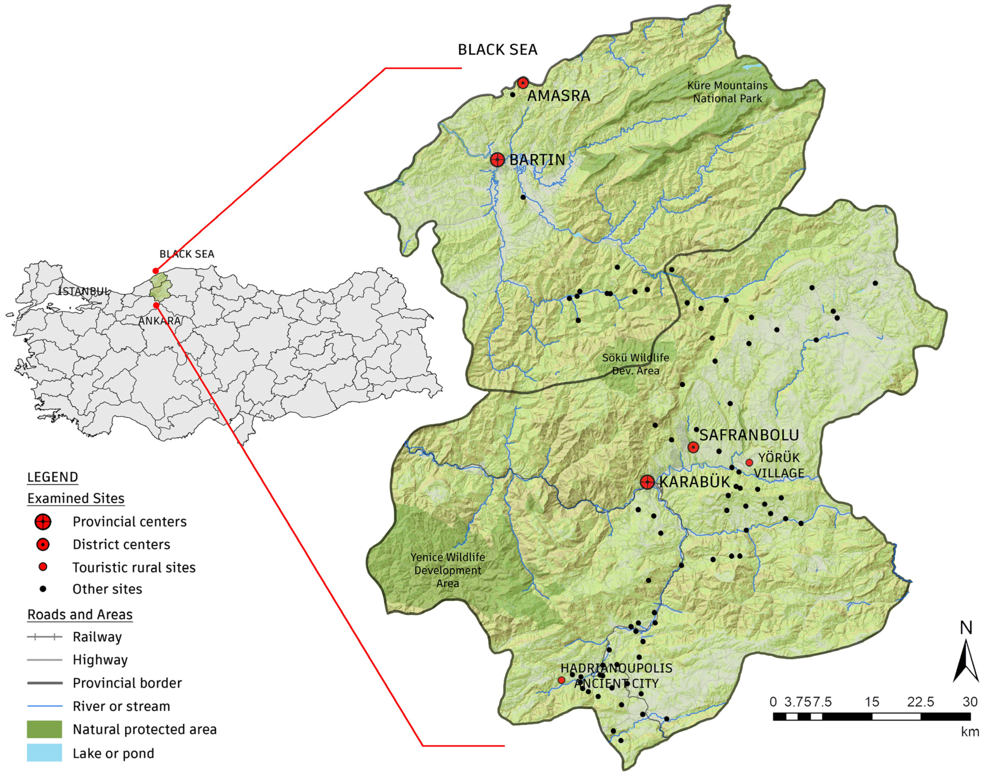
Figure 1. Examined sites in the research area.
Sustainability 17 03157 g001
Figure 2. Methodological flowchart.
Sustainability 17 03157 g002
Figure 3. (a) A photograph by Woods documenting villagers in Zopran (1906) [45]. (b) The same location as (a) in Zopran Village, years later.
Sustainability 17 03157 g003
Figure 4. (a) A field study conducted with students in a rural site. (b) A screenshot of the crowdsourcing (Fulcrum) app.
Sustainability 17 03157 g004
Figure 5. (a) A field study within the scope of the workshop. (b) A desk study within the scope of the workshop.
Sustainability 17 03157 g005
Figure 6. (a) A view of Safranbolu (Çukur) from the south. (b) Traffic congestion in the historic center of Safranbolu.
Sustainability 17 03157 g006
Figure 7. (a) The fortifications of Amasra as seen from the ancient harbor. (b) The overlooked fortifications in the touristic center of Amasra.
Sustainability 17 03157 g007
Figure 8. (a) A street in Bulak Village, located within the urban site area. (b) Karakoyunlu rock-cut tomb, currently within the archaeological site, documented by traveler Leonhard in 1903.
Sustainability 17 03157 g008
Figure 9. (a) Extensive forest areas between the provinces of Karabük and Bartın. (b) A canyon and geological formations near the village of Karapınar.
Sustainability 17 03157 g009
Figure 10. (a) Yazıkavak Village, surrounded by a quarry. (b) A waterway, dividing the area and restricting access to water for living organisms, leads to an electricity generation facility.
Sustainability 17 03157 g010
Figure 11. (a) Folk dances performed to the accompaniment of traditional music during the Village Day in Yörük (2000s) [76]. (b) Local women preparing traditional treats for guests during Yörük Village Day (2000s) [76].
Sustainability 17 03157 g011
Figure 12. (a) A meeting organized in Safranbolu by an international civil society organization with the participation of local stakeholders (1998). (b) An on-site study conducted as part of a participatory workshop in Yörük Village (1993).
Sustainability 17 03157 g012
Figure 13. Indicator density maps and radial charts of site scores.
Sustainability 17 03157 g013
Figure 14. SOMs for each indicator.
Sustainability 17 03157 g014
Figure 15. Proposal for eco-cultural route and heritage components along the route.
Sustainability 17 03157 g015
Figure 16. Collective cartographies created by sub-groups.
Sustainability 17 03157 g016
Table 1. Indicators and parameters used for the evaluation of sites.
IndicatorsParametersRating
Tangible Cultural Heritage (TCH)Values forming a fabric or presence of a protected site or multiple monuments3
Values forming a group or presence of a monument2
Preservation of some examples of values1
Authenticity is vastly degraded, or value is not detected0
Intangible Cultural Heritage (ICH)The value creates regional attractiveness3
The value creates local attractiveness2
The value only exists in memory1
Not enabling to identify value (due to abandonment, etc.)0
Natural Heritage
(NH)
Presence of protected site/area/registered cave3
Presence of a potential protected site/area/registered cave2
The presence of sustained natural habitat1
Irreversible degradation of natural values0
Accessibility to Basic Services (ABS)Three of the specified basic services can be provided3
Two of the specified basic services can be provided2
One of the specified basic services can be provided1
Lack of specified basic services0
Connectivity with Attraction Centers (CAC)Avg. of 0–15 km from the 3 nearest specified centers3
Avg. of 15.1–30 km from the 3 nearest specified centers2
Avg. of 30.1–45 km from the 3 nearest specified centers1
An average of at least 45 km0
Table 2. Weights and rankings of indicators according to the decision matrix.
IndicatorsTCHICHNHABSCACWeightingRank
Tangible Cultural Heritage1.001.730.872.231.270.252
Intangible Cultural Heritage 0.581.000.431.080.720.145
Natural Heritage1.152.351.001.821.760.291
Accessibility to Basic Services 0.450.930.551.000.850.144
Connectivity with Attraction Centers 0.791.380.571.171.000.183
Disclaimer/Publisher’s Note: The statements, opinions and data contained in all publications are solely those of the individual author(s) and contributor(s) and not of MDPI and/or the editor(s). MDPI and/or the editor(s) disclaim responsibility for any injury to people or property resulting from any ideas, methods, instructions or products referred to in the content.