
Harnessing Traditional Ecological Knowledge for Ecological Security Optimization in Karst Border Regions: A Case Study of Guangxi–Vietnam

 , , , , and
Abstract
1. Introduction
2. Materials and Methods
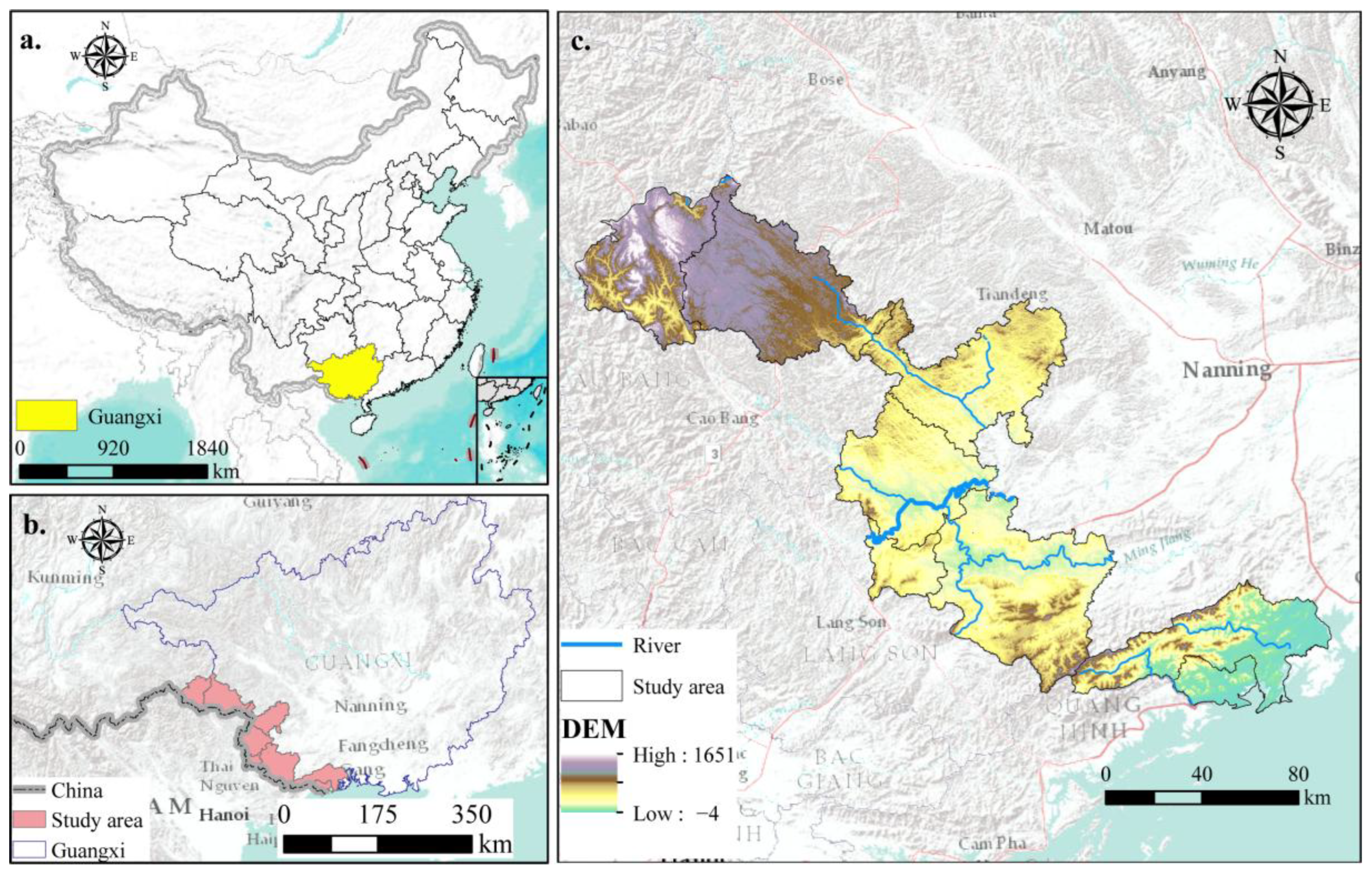
2.1. Study Area
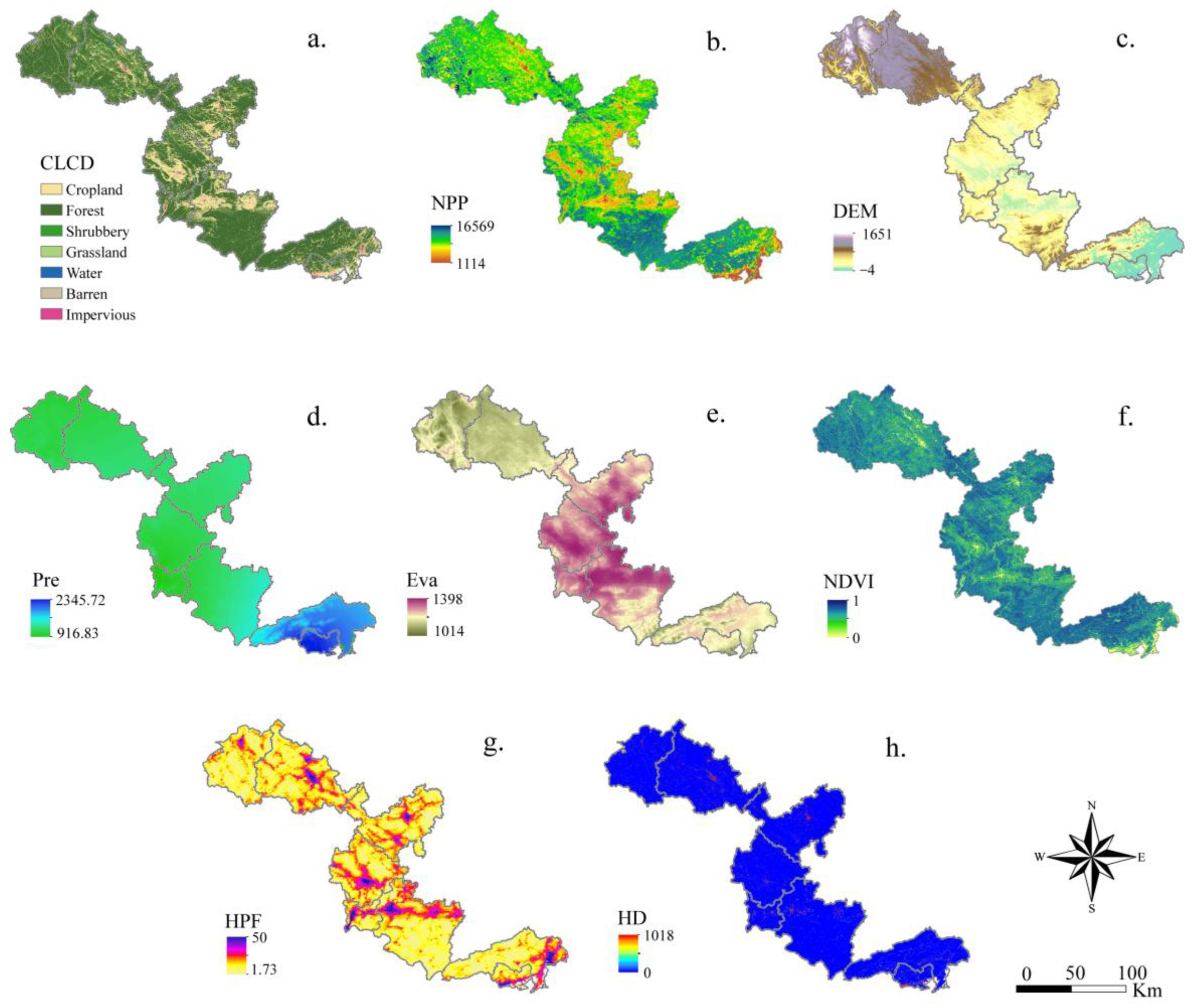
2.2. Data Sources
2.3. Methods
2.3.1. Source Identification
- (1)
- Biodiversity service function assessment
- (2)
- Water retention function
- (3)
- Soil and water conservation service function
- (4)
- Carbon sequestration service function
2.3.2. Resistance Surface Construction
- (1)
- Soil erosion sensitivity
- (2)
- Desertification sensitivity
- (3)
- Geological hazard sensitivity
2.4. Development of Ecological Security System
2.4.1. Extraction of Ecological Corridors
2.4.2. Evaluation of Ecological Pinch Points and Barrier Points
2.5. Ethnoecological Survey Method
3. Results
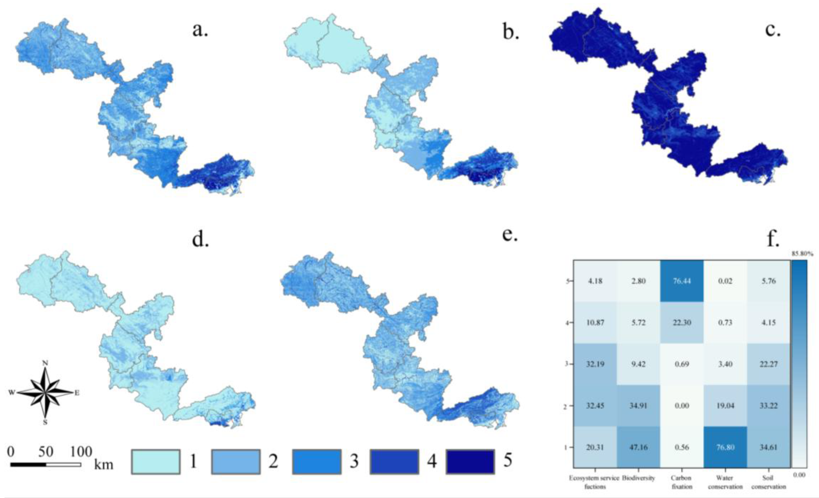
3.1. Significance of Ecosystem Functions
3.2. Ecological Sensitivity Assessment
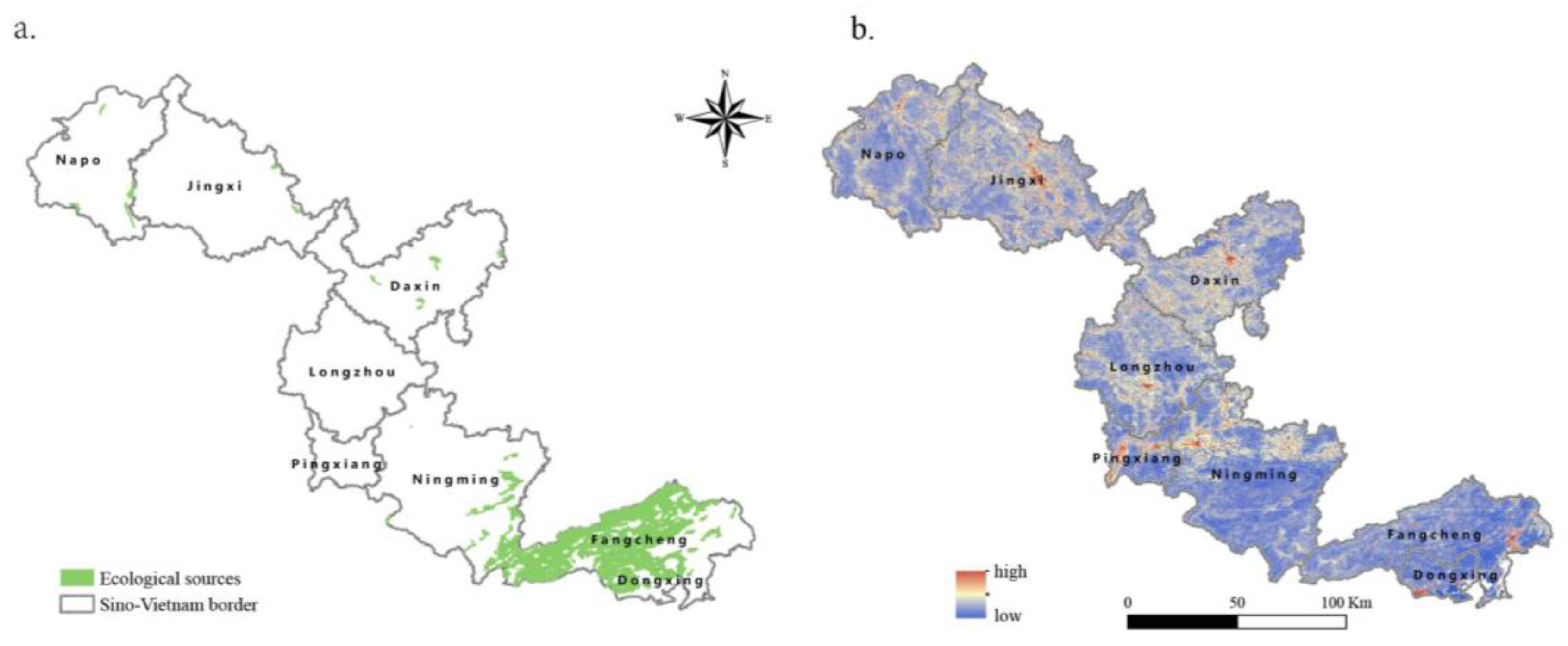
3.3. Source Identification
3.4. Construction and Modification of Resistance Surface
3.5. Evaluation of Ecological Corridors, Study, and Obstacle Points
3.5.1. Corridor Identification
3.5.2. Ecological Pinch Points
3.5.3. Ecological Barrier Points
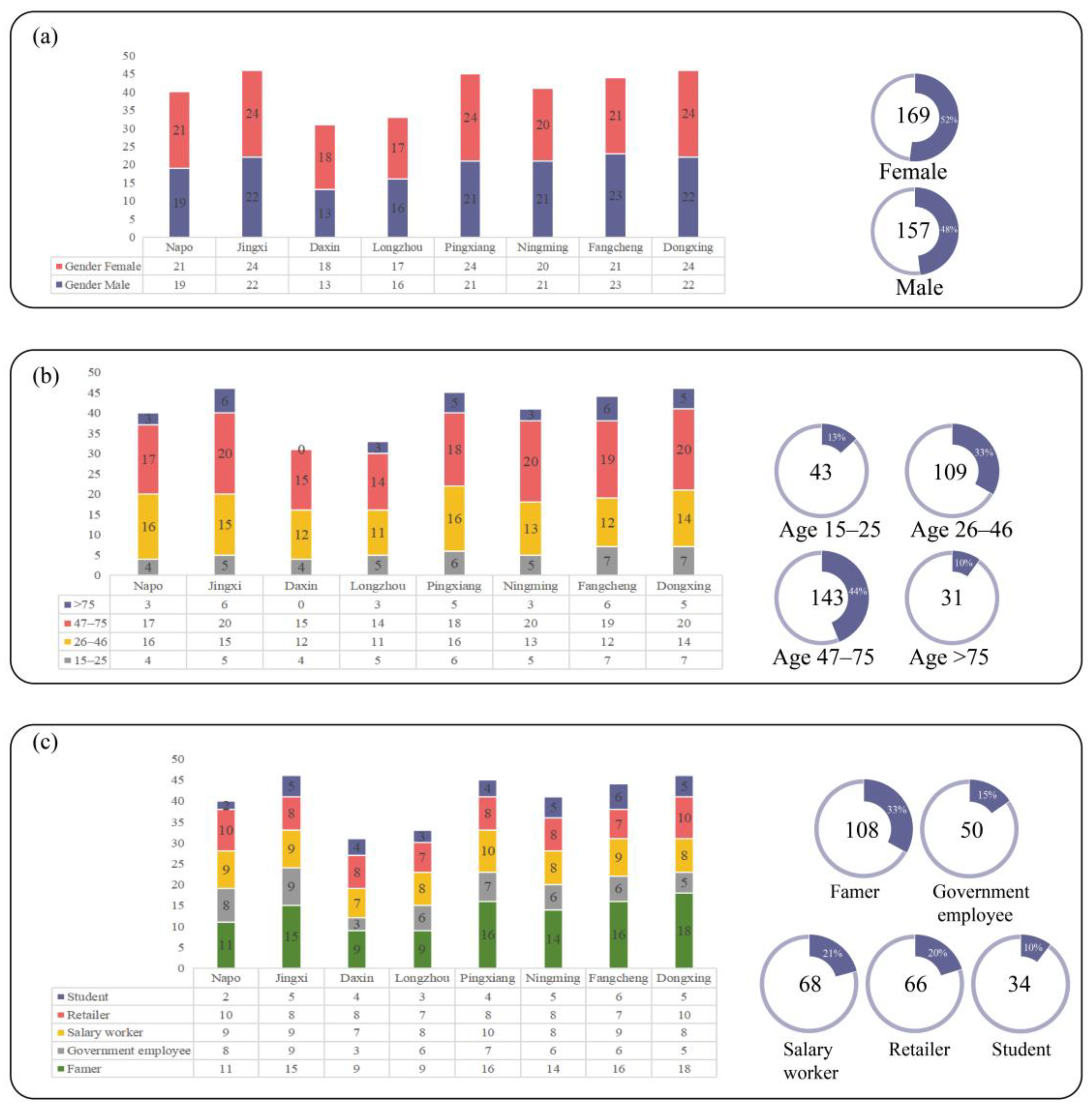
3.6. Survey on Traditional Ecological Knowledge
3.7. Optimization of Ecological Security System Combined with TEK
4. Discussion
4.1. Role of TEK in Karst Landform Ecological Protection
4.2. TEK in Cross-Border Ecological Protection
4.3. Limitations and Development of TEK in Ecological Applications
5. Conclusions
Author Contributions
Funding
Institutional Review Board Statement
Informed Consent Statement
Data Availability Statement
Acknowledgments
Conflicts of Interest
Appendix A

| Theme | Question List |
|---|---|
| Desertification control | What plants are usually grown and why? |
| What planting techniques or patterns have been explored? | |
| In addition to their ecological role, does planting these plants have other uses in personal life? | |
| Do institutions and beliefs play a role in desertification control? | |
| What do you think of the effectiveness of desertification control? | |
| Agriculture biodiversity | How can we make efficient use of limited land resources? |
| What farm varieties are there? | |
| What are their advantages and disadvantages? | |
| What is green ecological agriculture? | |
| What are some good experiences and methods? | |
| Is traditional farming culture conducive to the protection of the ecological environment? | |
| What are the specific benefits? | |
| Is it still being continued? Is it necessary to continue? | |
| Mangroves biodiversity | What are the specific measures for the protection of water birds? |
| Which plants are suitable for water birds to inhabit? | |
| What is the relationship between mangrove plants and production and life? | |
| Why should we protect mangroves? | |
| Plant diversity | What are the specific measures for protecting ancient trees? |
| Why are these trees protected? | |
| What are the ways in which we can utilize wild plant resources? | |
| What is the relationship between plants, folk customs, and festivals? | |
| TEK recognition | Where did the traditional usage come from? |
| Are these practices being taught to children and other younger generations? | |
| Is this knowledge, ways, or methods still important today? | |
| How can we protect this traditional knowledge? |
| Category | TEK | Introduction to TEK | Representative Biological Sources or Items | ||
|---|---|---|---|---|---|
| Local Name | Botanical Name | Specific Use/Functions | |||
| Rocky desertification response | Multi-level planting | Involving a variety of life forms, it has formed a Dashishan forest ecosystem dominated by deciduous broad-leaved tree species and with obvious structural levels. These plants are all needed for daily life. | Rendou Tree | Zenia insignis | Tree layer: building materials |
| Xiangchun Tree | Toona sinensis | ||||
| Caidou Tree | Radermachera sinica | ||||
| Kujian Tree | Melia azedarach | Arbor layer: using leaves to treat common diseases | |||
| Xishu | Camptotheca acuminata | Arbor layer: fruits are edible | |||
| Gou Tree | Broussonetia papyrifera | Arbor layer: leaves used as fodder | |||
| Huanglu | Cotinus coggygria var. cinereus | Shrub layer: treat jaundice | |||
| Zhuyehuajiao | Zanthoxylum armatum | Shrub layer: fruit can be made into seasoning | |||
| Jiahuangpi | Clausena excavata | Shrub layer: fruits and leaves are edible and can be used as seasoning | |||
| Diaosizhu | Dendrocalamus minor | Bamboo: bamboo weaving | |||
| Datoudianzhu | Bambusa beecheyana var. pubescens | Bamboo: bamboo weaving | |||
| Citou | Cephalaria alpina | Bamboo: edible | |||
| Fendanzhu | Bambusa chungii | Bamboo: bamboo weaving; bamboo leaves | |||
| Jinyinhua | Lonicera japonica | Fujimoto: tea substitute | |||
| Mubiezi | Momordica cochinchinensis | Fujimoto: food coloring | |||
| Wujiemang | Miscanthu floridulus | Herbaceous layer: the stems and flowers of Miscanthus quinquefolius are used to make brooms | |||
| Hongsixian | Lycianthes biflora | Herb layer: used as medicine to clear away heat and detoxify | |||
| Jianma | Agave sisalana | Herbaceous layer: leaves are used to make ropes | |||
| Tree God Worship | Locals will deliberately protect a Feng Shui forest, as they believe that if it is cut down, it will inevitably bring disaster, maintaining Feng-Shui forests and protecting specific tree species | Cuibai | Calocedrus macrolepis | The locals regard it as an ancestral tree and prohibit cutting it down. | |
| Chongyangmu | Bischofia polycarpa | When the branches are cut, red juice oozes out, giving it supreme divinity. It is believed to be a sacred object that protects life and the village, and no one is allowed to get too close or destroy it. | |||
| Planting native tree species | According to the characteristics of the local rocky mountain ecosystem, we selected native varieties with strong adaptability, easy growth, and high survival rate. | Rendou Tree | Zenia insignis | Commonly known as the “beheaded tree”, it has strong vitality and its roots can penetrate deep into the cracks of the rocks. | |
| Jinyinhua | Lonicera japonica | One Jinyihua plant can cover several or even dozens of square meters of large rocks, which can effectively reduce soil erosion and increase the ecological environment of the rocky mountain. | |||
| Optimizing planting techniques | By exploring the properties and characteristics of plants, we explore water conservation planting techniques and reduce soil erosion. | Kujian Tree | Melia azedarach | Plant Kujian trees on rainy days; dig holes for planting, pay special attention to compacting the soil around the seedlings, and look for weeds around to cover them, avoid direct sunlight, and increase the survival rate | |
| Rendou Tree | Zenia insignis | The planting of Rendou trees should be carried out after the spring rain. When planting, the trees should be buried deep and compacted. It is best to cover them with grass. The planting density should not be too dense. Appropriate interplanting of low-growing crops can be used to promote the growth of Rendou trees. | |||
| Diaosi bamboo | Dendrocalamus minor | Dig a hole for planting, find a stone piece about 20 cm long and 10 cm wide to cover it to prevent direct sunlight from shining on the tree. At the same time, some steam can be condensed at night to provide the bamboo with water for its initial survival. | |||
| Village rules and regulations | (1) The public should actively participate in afforestation and set a planting quantity; (2) The public should strengthen the management of the forests and not cut down trees indiscriminately. If anyone is found cutting trees illegally, he will be fined three trees for every one he cuts down; (3) Restrict people from other villages from cutting grass and cutting firewood: if they are caught for the first time, they will be educated; if they are caught for the second time, they will not be allowed to bring back firewood and will be fined; (4) Daughters who marry into other villages are not allowed to return to the village to claim the forests. | Feiniu Tree | Cephalomappa sinensis | Institutional guarantee for desertification control | |
| Forest resource management strategy | (1) Regarding the planning of the mountains and forests, no one is allowed to enter the mountains and forests near the villages without permission, and mowing, collecting firewood, and grazing are strictly prohibited. (2) The mountains and forests near the cultivated areas are only allowed to be entered for mowing and cutting vines, and young trees are not allowed to be cut. (3) The remote mountains and forests bordering other villages are closed in rotation and opened regularly to solve the difficulties of the masses in mowing and collecting firewood. (4) While implementing the mountain closure, the masses are mobilized to plant trees and bamboo every winter and spring, digging holes in the cracks of the rocks to plant trees and bamboo | Xianmu | Excentrodendron tonkinense | ||
| Mulberry and silkworm farming | Mulberry trees are suitable for growing in rocky desertification areas. Mulberry leaves are used to feed silkworms. Then, during the growth of mulberry trees, they are cut down twice a year in spring and autumn. The cut mulberry stalks can meet the current needs of people for firewood and cooking. | Sang tree | Morus alba | Solve the economic source of the rocky mountain area, reduce dependence on the mountains and forests, and alleviate the pressure on the rocky mountain ecosystem. | |
| Mangrove biodiversity conservation | Waterbird habitat protection | Based on their long-term interactions with water birds, the public consciously creates habitats based on the needs and habits of different water birds. | Mumahuang | Casuarina equisetifolia | Shore protection plants to prevent habitat degradation |
| Luoyushan | Taxodium distichum | ||||
| Kujian | Melia azedarach | ||||
| Baigurang | Avicennia marina | Bank protection plants | |||
| Tonghua Tree | Aegiceras corniculatum | ||||
| Qiuqie Tree | Kandelia obovata | ||||
| Mulan | Bruguiera gymnorhiza | ||||
| Farming and waterfowl foraging | The aquaculture area on the tidal flats and the foraging areas for water birds are highly overlapped. European breams often follow fishing boats in groups. After the fishermen catch the fish, they go to the deck to forage for food. Fishermen will also deliberately leave the seafood of poor quality for the water birds. In addition to the water bird habitats within the wetland red line, artificial wetlands such as fish ponds, salt pans, and shrimp ponds in the village also provide important supplements for water bird habitats. | Honzuiou | Larus ridibundus | Agriculturally beneficial birds, controlling pest populations | |
| Heizuiou | Larus saundersi | Their call patterns predict changes in weather | |||
| Qingjiaoyu | Tringa nebularia | Control insect populations and maintain ecological balance | |||
| Waterfowl breeding | Understand the breeding habits of waterfowl and consciously protect the habitats of waterfowl | Baixiongkue Bird | Amaurornis phoenicurus | Prefers bushes near water | |
| Heishuiij | Gallinula chloropus | Prefers shallow waters, reed beds, etc. | |||
| Heichihangjiaoyu | Himantopus himantopus | Prefers to be on a sunny beach or grassy area with a few plants | |||
| Bailianheng | Sitta leucopsis | Likes to be on the beach | |||
| Caiyu | Rostratula benghalensis | Prefers bushes near water | |||
| Tourism and water bird conservation | Based on their long-term interactions with water birds, the public consciously creates habitats based on the needs and habits of different water birds. | Bailu | Egretta garzetta | Transforming ecological value into economic value | |
| Protection and utilization of mangroves | Mangroves are known as “undersea forests” and have a wide range of uses. The trees can be used as building materials, the fruits can be eaten or used to make wine, and the tannin extracted from the bark can be used as a dye. | Baigurang | Avicennia marina | The fruit boiled in water can be eaten directly as a dish | |
| Tonghua Tree | Aegiceras corniculatum | A nectar plant, whose quality is second only to litchi honey and which has a high yield | |||
| Haiqi | Excoecaria agallocha | ||||
| Laoshule | Acanthus ilicifolius | Anti-cancer | |||
| Shuihuangpi | Pongamia pinnata | The pongamia bark of the Shuihuangpi has anti-inflammatory, antibacterial, and antiviral medicinal values | |||
| Houteng | Ipomoea pes-caprae | The intricately developed root system of mangroves can effectively retain the large amount of sediment that is transported from rivers to the ocean, thereby reducing the sand content in the coastal waters and effectively resisting the attacks of wind and waves. | |||
| Mulan | Bruguiera gymnorhiza | ||||
| Honghailan | Rhizophora stylosa | ||||
| Agricultural biodiversity conservation | Genetic resource diversity | The Sino-Vietnamese border region has a long history of agriculture and relatively rich local varieties. From the perspective of species and genes, not only are there many species of origin, but many high-quality gene types are unique to this country. The formation of these variety resource characteristics is closely related to the production and lifestyle of the local people and has rich traditional cultural knowledge. | Jingxi-Daxiang nuo | Oryza sativa | Jingxi-Daxiang nuo has few pests, high quality, and rich nutrition. According to the survey, there are at least six varieties of Jingxi Daxiang glutinous rice, and the genetic resources are very rich. |
| Jingxi-Damaya | Tadorna ferruginea | Jingxi-Damaya is the largest local fine duck breed in Guangxi. This breed has the advantages of large size, tolerance to roughage, strong foraging ability, and fast early growth rate. The duck has less subcutaneous fat, high meat yield at slaughter, tender meat, and delicious taste. | |||
| Jingxi-Daguoshanzha | Crataegus scabrifolia | The root system of the big-fruited hawthorn is well developed, which can effectively fix the soil and reduce soil erosion. At the same time, the fruit of the big-fruited hawthorn is rich in nutrients and medicinal value, and can be used as a source of food and medicine for local residents. At present, the cultivation of big-fruited hawthorn adopts traditional agricultural techniques and methods, such as crop rotation and intercropping, to effectively maintain soil fertility and water balance. | |||
| Pingxiang-Baiyumi | Zea mays | Drought resistant, good taste | |||
| Ecosystem diversity | The agricultural arable land area in the ChinaVietnam border area is barren. The ancestors here, in an environment with many mountains and little land, upgraded the production capacity and benefits from low efficiency to high efficiency and transformed from extensive to intensive, initially forming a green agricultural industry. | Sweet potato and rice rotation | Ipomoea batatas | Sweet potatoes are planted in October of the first year, and rice is planted after harvesting in May of the second year. In this way, one season of sweet potatoes and one season of rice can be harvested in a year, realizing the rotation of water and land. After harvesting sweet potatoes, the sweet potato vines are returned to the fields to conserve the land, which is both ecological and labor-saving, improves soil fertility, effectively eliminates farmland weeds and soil-borne pests and diseases, and promotes continuous increase in crop yields. | |
| Oryza sativa | |||||
| Tobacco–rice rotation | Nicotiana tabacum | Improve soil fertility, effectively eliminate farmland weeds and soil-borne pests and diseases, and promote sustained crop yield increases | |||
| Ipomoea batatas | |||||
| Fish and duck farming in rice fields | none | Multiple uses of one field, multiple uses of one water, and multiple harvests in one season not only improve resource utilization efficiency and effectively save water and soil resources, but also improve soil permeability, increase soil fertility, and control rice diseases and insect pests. | |||
| Terraced fields | none | It is the best agricultural production method for mountain people to make full use of local mountain resources to obtain agricultural products while conserving water and soil. | |||
| Interplanting of Wogan and Peanut | Citrus reticulata | The waste from intercropping becomes organic matter for the growth of fruit trees after fermentation. | |||
| Arachis hypogaea | |||||
| Macadamia and watermelon intercropping | Macadamia integrifolia | ||||
| Citrullus lanatus | |||||
| Diversity of agricultural culture | Traditional agricultural production depends on the natural environment, and the harvest after hard work is full of uncertainty. People pray to the gods for seeds and blessings through prayer ceremonies, which makes the uncertain agricultural production full of expectations. Therefore, many traditional cultures are preserved in the China–Vietnam border area, which promotes the protection of the local ecosystem. | Dabiandan | none | The Zhuang people’s Dabiandan activity originated from the labor of pounding rice. It developed from pounding rice to hitting the bench with a carrying pole. People beat the benches one after another in a staggered manner, demonstrating the Zhuang people’s transplanting, harvesting, threshing, and pounding rice. Local people of all ethnic groups pray to God for good weather, longevity, and good harvests through the “beating pole” activity. | |
| Niuhun Festival | none | On the eighth day of the fourth lunar month, farmers give their cows a day off. Each household repairs the cowshed and washes the cows. When the cows are bathing, they beat drums to cheer them up. The village elders comment on the cows in the village and warn each family to take good care of the oxen. Every family steams five-color glutinous rice and wraps it in loquat leaves to feed the cows. In some places, wine, meat, melons, and fruits are placed in the main hall as offerings. The head of the family leads an old cow around the offerings, singing as they walk, to praise and thank the cow for its merits. On this day, each household feeds the cow first, and then the whole family eats the festival meal. It shows the national ecological culture of an agricultural nation that cherishes oxen and protects productivity. | |||
| Shuangjiang | none | Eating glutinous rice cakes during the Frost Descent season is an important custom of the Zhuang people. They use glutinous rice cakes as a high-quality sacrifice to thank nature, celebrate the harvest, express gratitude for the grace of nature, and pray for a good harvest. | |||
| Conservation and utilization of plant diversity | Protection and utilization of endemic plants | According to statistics in the literature, there are 3118 seed plants in the karst area of the China–Vietnam border in Guangxi, of which 294 are endemic to Guangxi. They are concentrated in the genera of Begonia, Aspidistra, Spirochaete, Primulina, and Staircase. Some of these endemic plants have the value of being edible, medicinal, ornamental, and building materials, and are widely recognized by the public and protected and used by local people. | Jingxi-nan | Phoebe jingxiensis | The wood is very hard and is used by local people to make furniture, house pillars, and beams. The root system is thick and strong, making it an excellent tree species for desertification control. |
| Xianmu | Excentrodendron tonkinense | A plant endemic to tropical limestone, which can be used as various wood products, mostly in Longzhou | |||
| Shiwanshanzhizhubaodan | Aspidistra shiwandashanensis | The leaves of the spider egg are often used to make rice dumplings. The steamed rice dumplings have a fragrant and pleasant aroma. | |||
| Banliang-Yueju | Vaccinium bangliangense | Stone Mountain Greening | |||
| Kuanyeyufenghua | Habenaria lindleyana | Plants in limestone areas | |||
| Protection and utilization of ancient trees | In some streets and villages, many ancient trees have been preserved due to religious worship, and even a certain scale of “feng shui forest” dominated by a certain plant has been formed. For example, in Dongxing City, locals like five-color persimmon very much and call it hometown tree to ease homesickness. More importantly, in the past, food was scarce, and the fruit of this tree was mainly used to satisfy hunger. The oldest tree has now been preserved for about 500 years. According to the results of the second census of ancient trees and famous trees in Guangxi from 2016 to 2017, there are about 141,000 ancient trees and famous trees in the region. | Wuseshi | Diospyros kaki | Call it the hometown tree to ease homesickness | |
| Dayerong | Ficus altissima | Tolerant to drought and barrenness, strong winds, mostly in Jingxi | |||
| Yuenanyoucha | Camellia oleifera | In Madong Village, Shangshi Town, Pingxiang City, there is a large ancient tea tree group that is rare in Guangxi and even in the country—736.5 acres and 8937 century-old tea trees. | |||
| Conservation and utilization of animal diversity | Habitat protection | Understand the food properties of white-headed langurs. The tender leaves, buds, flowers, and fruits of common trees such as paper mulberry, kapok, bamboo, peach, Trichosanthes kirilowii, dung beetle, and red sedge are the favorites of white-headed langurs. Therefore, they are deliberately planted in the buffer areas outside the nature reserve. | Baitouyehou | Trachypithecus leucocephalus | It is a species endemic to China. It is a first-class protected wild animal and a rare and endangered primate. It lives in the subtropical karst area with lush vegetation in southern Guangxi, China. |
| Birdwatching economy | We have developed the bird-watching economy in a targeted manner, taking advantage of local conditions, and achieving the goals of increasing income, improving quality of life, and better protecting the ecology. | Nonggangsuimei | Stachyris nonggangensis | It is a typical karst bird, only distributed in the limestone areas of the karst mountains. In China, it is only distributed in the karst mountains in southwestern Guangxi. | |
References
- Zhang, P.; Song, M.; Lu, Q. Mapping ecological security patterns based on ecosystem service valuation in the Qinling-Daba Mountains area, China: A multi-scenario study for development and conservation tradeoffs. Land 2024, 13, 1629. [Google Scholar] [CrossRef]
- Sadeghi, S.H.; Zabihi Silabi, M.; Sarvi Sadrabad, H.; Riahi, M.; Modarresi Tabatabaei, S. Watershed health and ecological security modeling using anthropogenic, hydrologic, and climatic factors. Nat. Resour. Model. 2023, 36, e12371. [Google Scholar] [CrossRef]
- Nie, W.; Xu, B.; Yang, F.; Shi, Y.; Liu, B.; Wu, R.; Lin, W.; Pei, H.; Bao, Z. Simulating future land use by coupling ecological security patterns and multiple scenarios. Sci. Total Environ. 2023, 859, 160262. [Google Scholar] [CrossRef] [PubMed]
- Dong, G.; Liu, Z.; Niu, Y.; Jiang, W. Identification of land use conflicts in Shandong province from an ecological security perspective. Land 2022, 11, 2196. [Google Scholar] [CrossRef]
- Ding, M.; Liu, W.; Xiao, L.; Zhong, F.; Lu, N.; Zhang, J.; Zhang, Z.; Xu, X.; Wang, K. Construction and optimization strategy of ecological security pattern in a rapidly urbanizing region: A case study in central-south China. Ecol. Indic. 2022, 136, 108604. [Google Scholar] [CrossRef]
- Jia, Q.; Jiao, L.; Lian, X.; Wang, W. Linking supply-demand balance of ecosystem services to identify ecological security patterns in urban agglomerations. Sustain. Cities Soc. 2023, 92, 104497. [Google Scholar] [CrossRef]
- Wu, Y.; Han, Z.; Meng, J.; Zhu, L. Circuit theory-based ecological security pattern could promote ecological protection in the Heihe River Basin of China. Environ. Sci. Pollut. Res. 2023, 30, 27340–27356. [Google Scholar] [CrossRef]
- Liu, P.X.; Liu, Y.; Li, T.N.; Guo, W.W.; Yang, A.L.; Yang, X.; Li, E.; Wang, Z.J. Identification and trend analysis of ecological security pattern in Mudanjiang City based on MSPA-MCR-PLUS model. Sustain. Sci. 2024, 16, 9690. [Google Scholar] [CrossRef]
- Liu, C.; Li, W.; Xu, J.; Zhou, H.; Li, C.; Wang, W. Global trends and characteristics of ecological security research in the early 21st century: A literature review and bibliometric analysis. Ecol. Indic. 2022, 137, 108734. [Google Scholar] [CrossRef]
- Chen, J.; Wang, S.; Zou, Y. Construction of an ecological security pattern based on ecosystem sensitivity and the importance of ecological services: A case study of the Guanzhong Plain urban agglomeration, China. Ecol. Indic. 2022, 136, 108688. [Google Scholar] [CrossRef]
- Liu, X.; Su, Y.; Li, Z.; Zhang, S. Constructing ecological security patterns based on ecosystem services trade-offs and ecological sensitivity: A case study of Shenzhen Metropolitan area, China. Ecol. Indic. 2023, 154, 110626. [Google Scholar] [CrossRef]
- Liu, H.; Wang, Z.; Li, L.Z.T.W. Construction of an ecological security network in the Fenhe River Basin and its temporal and spatial evolution characteristics. J. Clean. Prod. 2023, 417, 137961.1–137961.11. [Google Scholar] [CrossRef]
- Li, L.; Huang, X.; Wu, D.; Yang, H. Construction of ecological security pattern adapting to future land use change in Pearl River Delta, China. Appl. Geogr. 2023, 154, 102946. [Google Scholar] [CrossRef]
- Yang, L.; Li, Y.; Jia, L.; Ji, Y.; Hu, G. Ecological risk assessment and ecological security pattern optimization in the middle reaches of the Yellow River based on ERI+MCR model. J. Geogr. Sci. 2023, 33, 823–844. [Google Scholar] [CrossRef]
- Yang, Z.; Ma, C.; Liu, Y.; Zhao, H.; Hua, Y.; Ou, S.; Fan, X. Provincial-scale research on the eco-security structure in the form of an ecological network of the upper yellow river: A case study of the Ningxia Hui Autonomous Region. Land 2023, 12, 1341. [Google Scholar] [CrossRef]
- Lai, S.; Sha, J.; Eladawy, A.; Li, X.; Wang, J.; Kurbanov, E.; Lin, Z.; Wu, L.; Han, R.; Su, Y.C. Evaluation of ecological security and ecological maintenance based on pressure-state-response (PSR) model, case study: Fuzhou City, China. Hum. Ecol. Risk Assess. 2022, 28, 734–761. [Google Scholar] [CrossRef]
- He, H.; Yu, X.; Yu, H.; Ma, Z.; Luo, Y.; Liu, T.; Rong, Z.; Xu, J.; Chen, D.; Li, P. Suitable habitat evaluation and ecological security pattern optimization for the ecological restoration of Giant Panda habitat based on nonstationary factors and MCR model. Ecol. Model. 2024, 494, 110760. [Google Scholar] [CrossRef]
- Hu, Y.; Gong, J.; Li, X.; Song, L.; Zhang, Z.; Zhang, S.; Zhang, W.; Dong, J.; Dong, X. Ecological security assessment and ecological management zoning based on ecosystem services in the West Liao River Basin. Ecol. Eng. 2023, 192, 106973. [Google Scholar] [CrossRef]
- Fu, B.; Liu, Y.; Meadows, M.E. Ecological restoration for sustainable development in China. Nat. Sci. Rev. 2023, 10, nwad033. [Google Scholar] [CrossRef]
- Han, P.; Hu, H.; Jiang, M.; Wang, M. Construction of wetland ecological security pattern in Wuhan Metropolitan core area considering wetland ecological risk. Land 2024, 13, 1407. [Google Scholar] [CrossRef]
- Yang, J.; Wang, S.; Zhou, J.; Zhang, J.; Zhang, W. Optimisation of ecological security patterns in ecologically transition areas under the perspective of ecological resilience—A case of Taohe river. Ecol. Indic. 2024, 166, 112315. [Google Scholar]
- Gao, M.; Hu, Y.; Bai, Y. Construction of ecological security pattern in national land space from the perspective of the community of life in mountain, water, forest, field, lake and grass: A case study in Guangxi Hechi, China. Ecol. Indic. 2022, 139, 108867. [Google Scholar] [CrossRef]
- Zeng, W.; Tang, H.; Liang, X.; Hu, Z.; Yang, Z.J.; Guan, Q.F. Using ecological security pattern to identify priority protected areas: A case study in the Wuhan metropolitan area, China. Ecol. Indic. 2023, 148, 110121. [Google Scholar] [CrossRef]
- Li, L.; Huang, X.; Wu, D.; Wang, Z.; Yang, H. Optimization of ecological security patterns considering both natural and social disturbances in China’s largest urban agglomeration. Ecol. Eng. 2022, 180, 106647. [Google Scholar] [CrossRef]
- Cui, X.; Deng, W.; Yang, J.; Huang, W.; de Vries, W.T. Construction and optimization of ecological security patterns based on social equity perspective: A case study in Wuhan, China. Ecol. Indic. 2022, 136, 108714. [Google Scholar] [CrossRef]
- Lin, S.; Zhu, P.; Lu, R.; Bi, J. The influence of trade-economy-population system on regional differences of territorial space pattern evolution in border areas: Take the China-Vietnam border zone as a case. J. Nat. Resour. 2023, 38, 1550–1569. [Google Scholar]
- Sun, M.; Zhang, L.; Yang, R.; Li, X.; Zhang, Y.; Lu, Y. Construction of an integrated framework for assessing ecological security and its application in Southwest China. Ecol. Indic. 2023, 148, 110074. [Google Scholar] [CrossRef]
- Huang, T.; Wang, N.; Luo, X.; Xu, J. Landscape ecological risks assessment of the China-Vietnam border area: The perspective of production-living-ecological spaces. Reg. Environ. Chang. 2024, 24, 103. [Google Scholar] [CrossRef]
- Liao, C.; Yue, Y.; Wang, K.; Fensholt, R.; Tong, X.; Brandt, M. Ecological restoration enhances ecosystem health in the karst regions of southwest China. Ecol. Indic. 2018, 90, 416–425. [Google Scholar] [CrossRef]
- Cao, N.; Xue, D. On biodiversity conservation by Zhuang traditional culture: A case study in Jingxi City of Guangxi Zhuang Autonomous Region. Biodivers. Sci. 2019, 27, 728. [Google Scholar]
- Xie, B.; Jones, P.; Dwivedi, R.; Bao, L.; Liang, R. Evaluation, comparison, and unique features of ecological security in southwest China: A case study of Yunnan Province. Ecol. Indic. 2023, 153, 110453. [Google Scholar] [CrossRef]
- Steger, C.; Kande, S.; Diop, D.; Sall, M.; Mbow, C.; Sène, A.; Wood, S. Local ecological knowledge indicates pathways towards equitable and sustainable management of the Sudano-Guinean Savanna. Hum. Ecol. 2023, 51, 1217–1238. [Google Scholar] [CrossRef]
- Ba, Q.X.; Wang, H.Z.; Wang, M.H. Agrobiodiversity, social institutions, and indigenous farming practices: A case study of the Rukai in Wutai, Taiwan. Hum. Ecol. 2023, 51, 1127–1140. [Google Scholar] [CrossRef]
- Wang, Y.Q.; Hu, Y.C.; Gao, M.W.; Niu, S. Land-space ecological restoration zoning of karst rocky desertification areas in Guangxi from multi-dimensional perspectives. Transact. Chin. Soc. Agric. Eng. Trans. CSAE 2023, 39, 223–231. [Google Scholar]
- Yang, J.; Huang, X. The 30 m annual landcover dataset and its dynamics in China from 1990 to 2019. Earth Syst. Sci. 2021, 13, 3907–3925. [Google Scholar] [CrossRef]
- Chen, S.; Li, L.; Li, X.; Li, D.; Wu, Y.; Ji, Z. Identification and optimization strategy for the ecological security pattern in Henan province based on matching the supply and demand of ecosystem services. Land 2023, 12, 1307. [Google Scholar] [CrossRef]
- Dash, S.S.; Sahoo, B.; Raghuwanshi, N.S. How reliable are the evapotranspiration estimates by Soil and Water Assessment Tool (SWAT) and Variable Infiltration Capacity (VIC) models for catchment-scale drought assessment and irrigation planning? J. Hydrol. 2021, 592, 125838. [Google Scholar] [CrossRef]
- Liu, F.; Zhao, J.; Lin, Y.; Chen, G.; Zhang, L.; Peng, F.F. Temporal land spatial evolution and driving force analysis of water conservation function in Yunnan Province based on climate and land use change. J. Soil Water Conserv. 2024, 38, 212–224. [Google Scholar]
- Zhou, Y.; Zhang, Y.; Wang, Q.; Chi, G.; Jiang, B. Transition of production-living-ecological space and carbon effect in Heilongjiang Province. Chin. J. Soil Sci. 2024, 55, 901–911. [Google Scholar]
- Sun, L.; Liu, H.; Wang, D.; Hao, H. Research on ecological security pattern construction based on the evaluation of ecosystem services and eco-environmental sensitivity. Res. Environ. Sci. 2022, 35, 2508–2517. [Google Scholar]
- Xu, Y.; Liu, R.; Xue, C.; Xia, Z. Ecological sensitivity evaluation and explanatory power analysis of the Giant Panda National Park in China. Ecol. Indic. 2023, 146, 109792. [Google Scholar] [CrossRef]
- Wang, N.; Zhao, Y. Construction of an ecological security pattern in Jiangnan water network area based on an integrated Approach: A case study of Gaochun, Nanjing. Ecol. Indic. 2024, 158, 111314. [Google Scholar] [CrossRef]
- Zhang, Q.; Wu, Y.; Zhao, Z. Identification of Harbin ecological function degradation areas based on ecological importance assessment and ecological sensitivity. Sustainability 2024, 16, 6763. [Google Scholar] [CrossRef]
- McRae, B.H.; Dickson, B.G.; Keitt, T.H.; Shah, V.B. Using circuit theory to model connectivity in ecology, evolution, and conservation. Ecology 2008, 89, 2712–2724. [Google Scholar] [CrossRef]
- McRae, B.H.; Hall, S.A.; Beier, P.; Theobald, D.M. Where to restore ecological connectivity? Detecting barriers and quantifying restoration benefits. PLoS ONE 2012, 7, e52604. [Google Scholar] [CrossRef]
- Kamakaula, Y. Cultural perspectives on climate change adaptation in agriculture an ethnoecological study. West. Sci. Interdiscip. Studies. 2024, 2, 743–748. [Google Scholar] [CrossRef]
- Aijaz, M.; Mir, R.A.; Hamid, E. Ethnoecological knowledge and conservation status of plant resources in the Himalayan dry temperate forests of Kashmir, India. Ethnobot. Res. Appl. 2024, 27, 29. [Google Scholar] [CrossRef]
- Yao, W.; Liu, Q.; Wen, Y.; Mganga, K.Z.; Tian, B.; Yang, Y.; Zeng, Y.; Qi, Z.; Jones, D.L.; Zang, H. Increased seasonal fallow intensity enhanced the soil fertility of latosol in a tropical multi-cropping region. Soil Tillage Res. 2025, 246, 106362. [Google Scholar] [CrossRef]
- Jiang, S.; Xiong, K.; Xiao, J. Structure and stability of agroforestry ecosystems: Insights into the improvement of service supply capacity of agroforestry ecosystems under the karst rocky desertification control. Forests 2022, 13, 878. [Google Scholar] [CrossRef]
- Ngo, T.T.H.; Nguyen, T.P.M.; Duong, T.H.; Ly, T.H. Forest—Related culture and contribution to sustainable development in the northern mountain region in Vietnam. For. Soc. 2021, 5, 32–47. [Google Scholar] [CrossRef]
- Cuc, L.T. Vietnam: Traditional cultural concepts of human relations with the natural environment. Asian Geogr. 1999, 18, 67–74. [Google Scholar] [CrossRef]
- Turner, N.J.; Cuerrier, A.; Joseph, L. Well grounded: Indigenous Peoples’ knowledge, ethnobiology and sustainability. People Nat. 2022, 4, 627–651. [Google Scholar] [CrossRef]
- Clement, S.; Moore, S.A.; Lockwood, M. Letting the managers manage: Analyzing capacity to conserve biodiversity in a cross-border protected area network. Ecol. Soc. 2016, 21, 39. [Google Scholar] [CrossRef]


| Data | Spatial Resolution | Sources | |
|---|---|---|---|
| Land use data | China land cover dataset (CLCD) | 30 m | https://zenodo.org/records/ (accessed on 15 April 2024) |
| Environmental data | Net primary productivity (NPP) | 500 m | https://earthengine.google.com/ (accessed on 15 April 2024) |
| Digital elevation model (DEM) | 30 m | https://www.nesdc.org.cn/ (accessed on 15 April 2024) | |
| Precipitation (Pre) | 1 km | https://data.tpdc.ac.cn/ (accessed on 15 April 2024) | |
| Evapotranspiration (Eva) | 1 km | https://www.geodata.cn/ (accessed on 15 April 2024) | |
| Soil information | 1 km | https://www.fao.org/ (accessed on 15 April 2024) | |
| Normalized difference vegetation index (NDVI) | 30 m | https://www.nesdc.org.cn/ (accessed on 15 April 2024) | |
| Human activity data | Human footprint index (HFP) | 100 m | https://www.earthdata.nasa.gov/ (accessed on 15 April 2024) |
| Human density (HD) | 90 m | https://landscan.ornl.gov/ (accessed on 15 April 2024) | |
| Type of Land Use | Cabove | Cbelow | Csoil | Cdead |
|---|---|---|---|---|
| Cropland | 11.62 | 2.32 | 14.92 | 1 |
| Forest | 50.16 | 12.54 | 16.98 | 3.5 |
| Shrubbery | 32.92 | 8.23 | 9.7 | 2.47 |
| Grassland | 2.59 | 11.64 | 13.77 | 1 |
| Water | 0.18 | 0 | 0 | 0 |
| Barren | 1.81 | 0 | 9.77 | 0 |
| Impervious | 1.03 | 0.8 | 10.74 | 0 |
| Threat | Optimum Distance | Weight | Decay |
|---|---|---|---|
| Cropland | 2 km | 0.5 | linear |
| Impervious | 10 km | 1 | exponential |
| Railway | 5 km | 0.6 | exponential |
| Road | 2 km | 0.6 | exponential |
| Habitat Types | Habitat Value | Cropland | Impervious | Railway | Road |
|---|---|---|---|---|---|
| Cropland | 0.6 | 0.4 | 0.6 | 0.5 | 0.6 |
| Forest | 1 | 0.7 | 0.9 | 0.9 | 0.9 |
| Shrubbery land | 1 | 0.6 | 0.5 | 0.5 | 0.5 |
| Grass | 0.7 | 0.7 | 0.75 | 0.4 | 0.75 |
| Water | 0.9 | 0.7 | 0.9 | 0.85 | 0.9 |
| Bare ground | 0 | 0 | 0.4 | 0.9 | 0.9 |
| Impervious | 0.2 | 0.2 | 0 | 0.2 | 0.1 |
| Evaluation Index | Minimum Sensitivity | Lower Sensitivity | Medium Sensitivity | Higher Sensitivity | Maximum Sensitivity |
|---|---|---|---|---|---|
| 1 | 3 | 5 | 7 | 9 | |
| Rainfall erosivity | <6963 | <9878 | <12792 | <15149 | >15149 |
| Soil erodibility | 0–0.2 | 0.2–0.54 | 0.54–0.69 | 0.69–0.82 | 0.82–1 |
| Topographic relief | <67 | 67–124 | 124–178 | 178–245 | 245–686 |
| FVC | 0 | 0–0.68 | 0.68–0.85 | 0.85–0.93 | 0.93–1 |
| D (%) | 0–3 | 3–6 | 6–9 | 9–12 | 12–15 |
| Slope | 0–8 | 8–17 | 17–26 | 26–37 | 37–78 |
| NDVI | 0–0.38 | 0.38–0.62 | 0.62–0.78 | 0.78–0.86 | 0.86–1 |
| HPF | 1.72–10.63 | 10.63–16.49 | 16.49–23.31 | 23.31–33.34 | 33.34–50 |
Disclaimer/Publisher’s Note: The statements, opinions and data contained in all publications are solely those of the individual author(s) and contributor(s) and not of MDPI and/or the editor(s). MDPI and/or the editor(s) disclaim responsibility for any injury to people or property resulting from any ideas, methods, instructions or products referred to in the content. |
© 2025 by the authors. Licensee MDPI, Basel, Switzerland. This article is an open access article distributed under the terms and conditions of the Creative Commons Attribution (CC BY) license (https://creativecommons.org/licenses/by/4.0/).
Share and Cite
Teng, M.; Liu, S.; Cao, W.; Huang, C.; Huang, Y.; Long, C. Harnessing Traditional Ecological Knowledge for Ecological Security Optimization in Karst Border Regions: A Case Study of Guangxi–Vietnam. Sustainability 2025, 17, 2858. https://doi.org/10.3390/su17072858
Teng M, Liu S, Cao W, Huang C, Huang Y, Long C. Harnessing Traditional Ecological Knowledge for Ecological Security Optimization in Karst Border Regions: A Case Study of Guangxi–Vietnam. Sustainability. 2025; 17(7):2858. https://doi.org/10.3390/su17072858
Chicago/Turabian StyleTeng, Mingkun, Sizhao Liu, Wanzheng Cao, Changyin Huang, Yunfang Huang, and Chunlin Long. 2025. "Harnessing Traditional Ecological Knowledge for Ecological Security Optimization in Karst Border Regions: A Case Study of Guangxi–Vietnam" Sustainability 17, no. 7: 2858. https://doi.org/10.3390/su17072858
APA StyleTeng, M., Liu, S., Cao, W., Huang, C., Huang, Y., & Long, C. (2025). Harnessing Traditional Ecological Knowledge for Ecological Security Optimization in Karst Border Regions: A Case Study of Guangxi–Vietnam. Sustainability, 17(7), 2858. https://doi.org/10.3390/su17072858