Determination and Sensitivity Analysis of Urban Waterlogging Driving Factors Based on Spatial Analysis Method
Abstract
1. Introduction
2. Study Area and Datasets
2.1. Study Area
2.2. Datasets
2.3. Data Processing
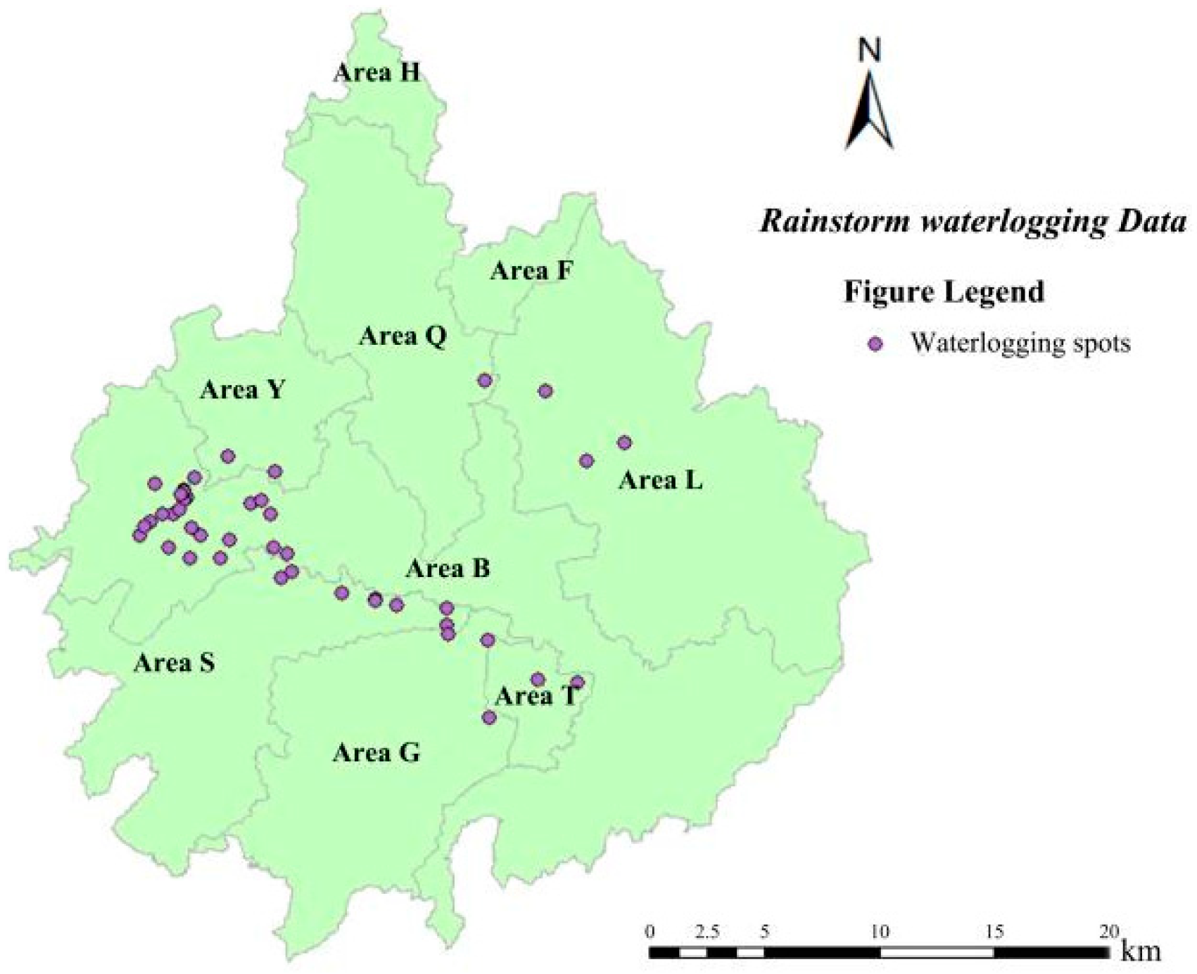
2.3.1. Rainstorm Waterlogging Data
2.3.2. Driving Factors of Rainstorm Waterlogging
- (1)
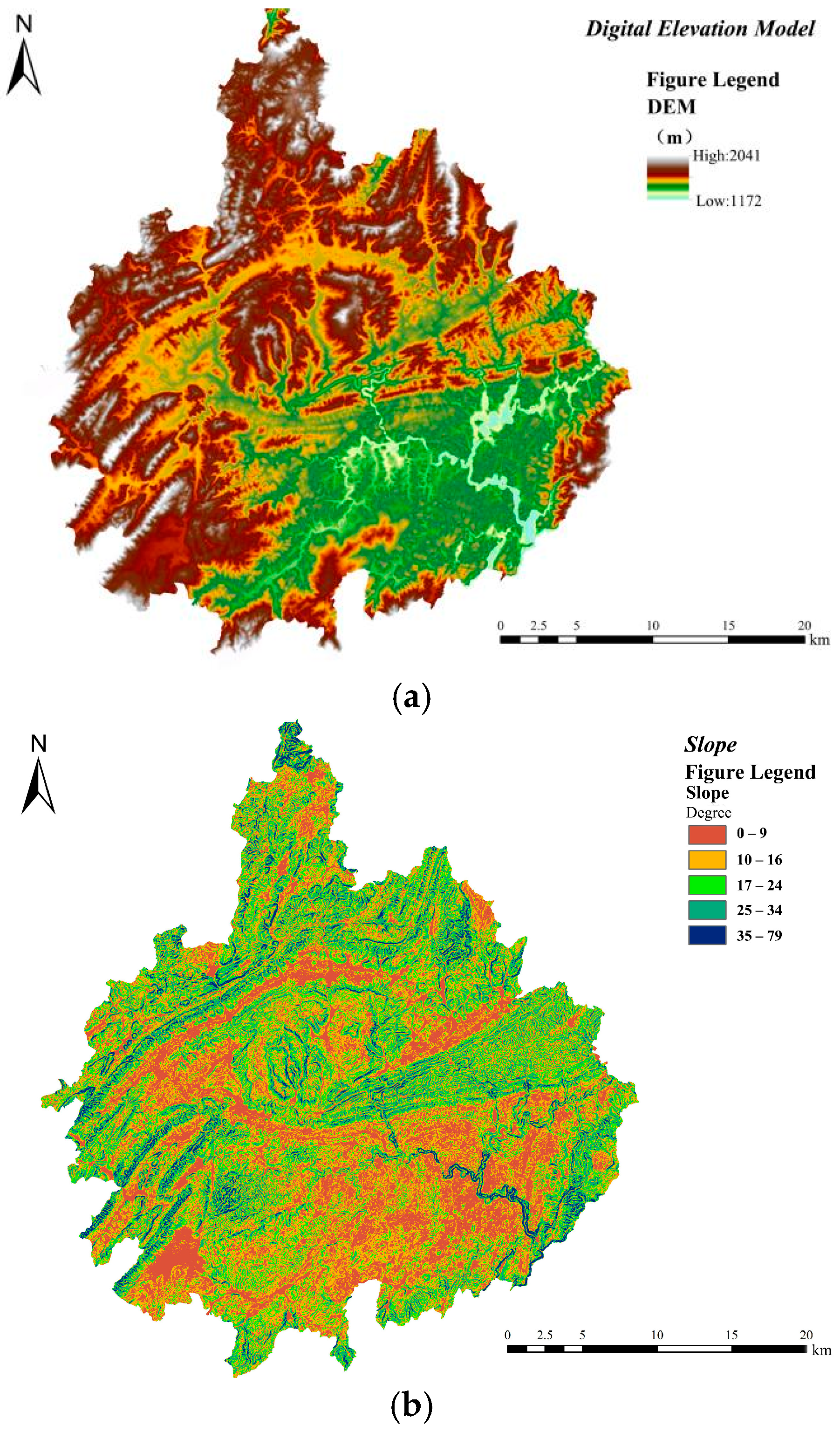
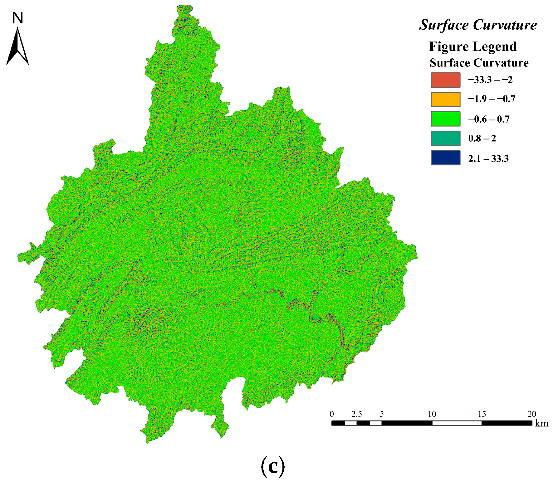
- Topographic Characteristics
- (2)
- Land Cover Characteristics
- (3)
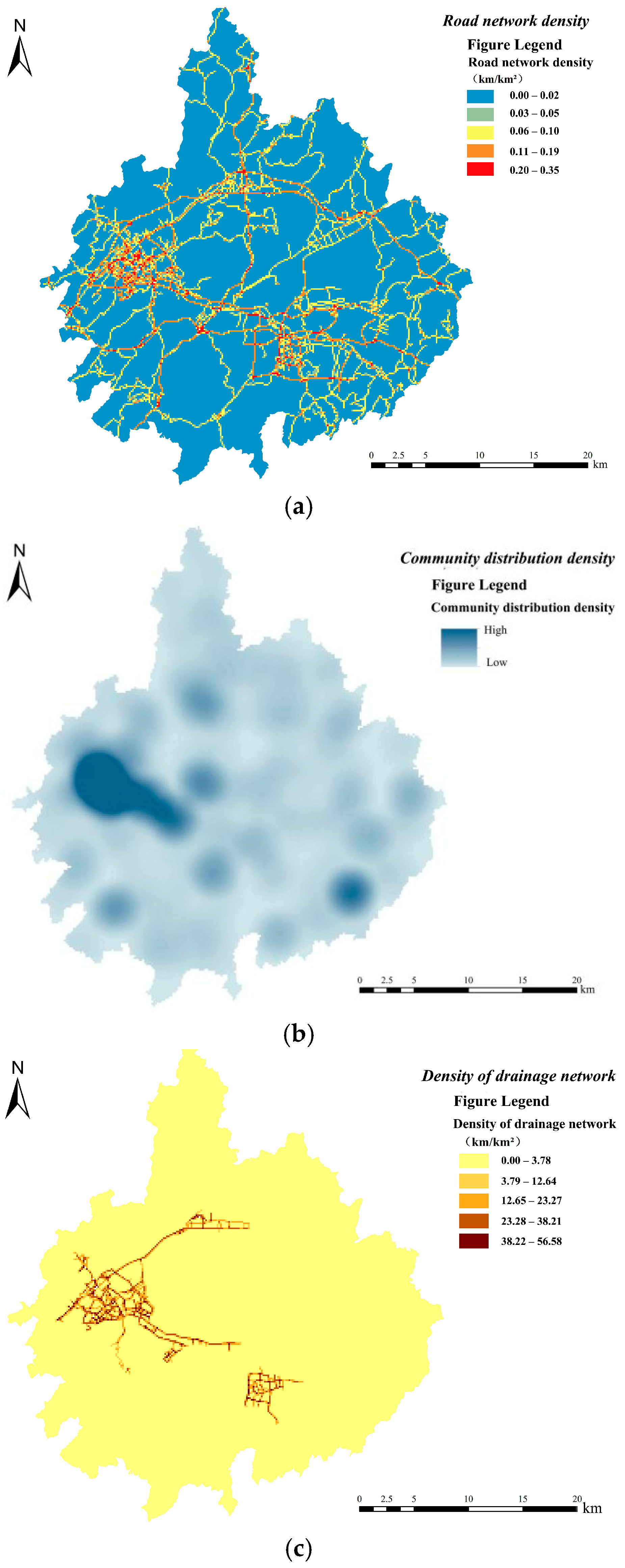
- Infrastructure Construction Characteristics
3. Analysis Methods
3.1. Kernel Density Estimation
3.2. Spatial Autocorrelation Analysis Method
3.2.1. Global Spatial Autocorrelation Analysis
3.2.2. Local Spatial Autocorrelation Analysis
3.3. Geographical Detector
- (1)
- Differentiation and factor detection
- (2)
- Interaction Detection
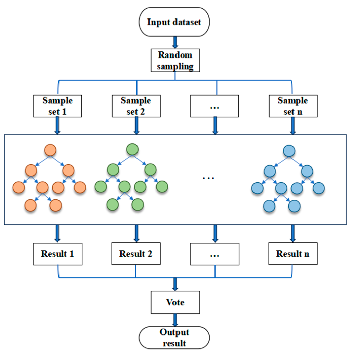
3.4. Random Forest Regression Model
4. Result
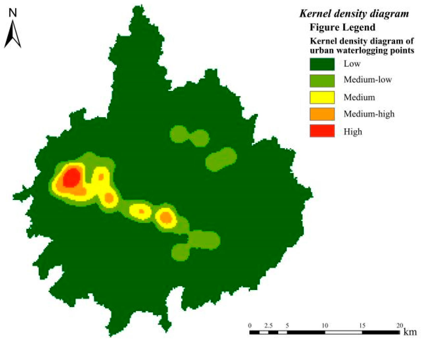
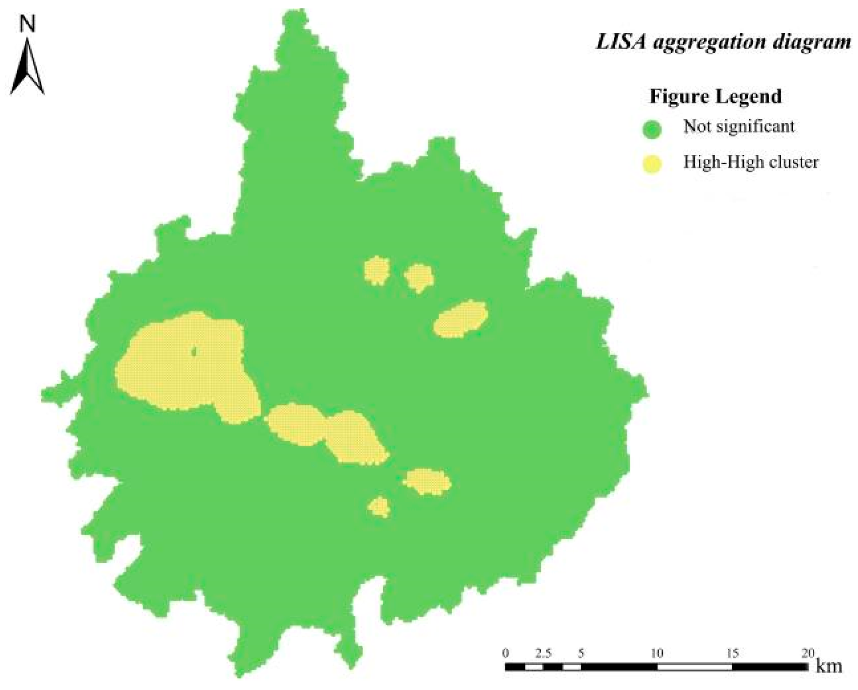
4.1. Spatial Correlation Analysis of Urban Waterlogging and Ponding Points
4.2. Analysis of Driving Factors for Waterlogging Disasters
4.2.1. Analysis of Waterlogging Driving Factors Based on Geographical Detector
- (1)
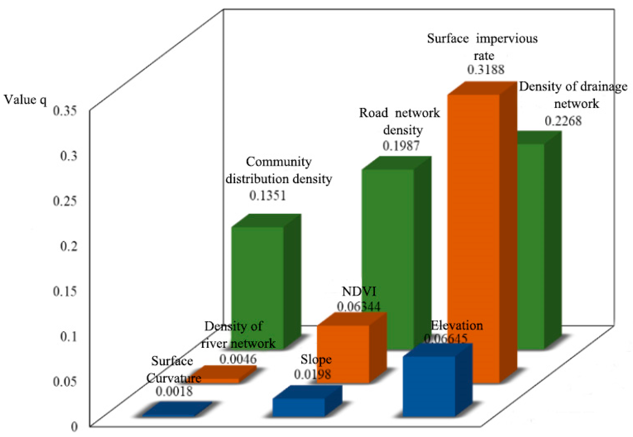
- Analysis of Differentiation and Factor Detection
- (2)
- Detection of Interaction
4.2.2. Analysis of Driving Factors for Waterlogging Based on Random Forest Model
4.3. Division of Waterlogging Disaster Sensitivity Areas
5. Discussion
5.1. Mechanism of Driving Factors for Urban Waterlogging
5.2. Suggestions for Mitigating the Risk of Urban Waterlogging
6. Conclusions
- The research findings reveal that through kernel density analysis and spatial autocorrelation analysis, the distribution of waterlogging within the investigated area exhibits spatial non-uniformity. Additionally, the rainstorm waterlogging points demonstrate a pronounced spatial clustering characteristic, mainly being distributed in the westward and southward areas of the central part of the central urban area, which are precisely the regions with dense built-up areas, thus presenting a spatial clustering distribution pattern. In areas where the waterlogging situation is relatively serious, the surrounding areas are also more likely to experience rainstorm waterlogging.
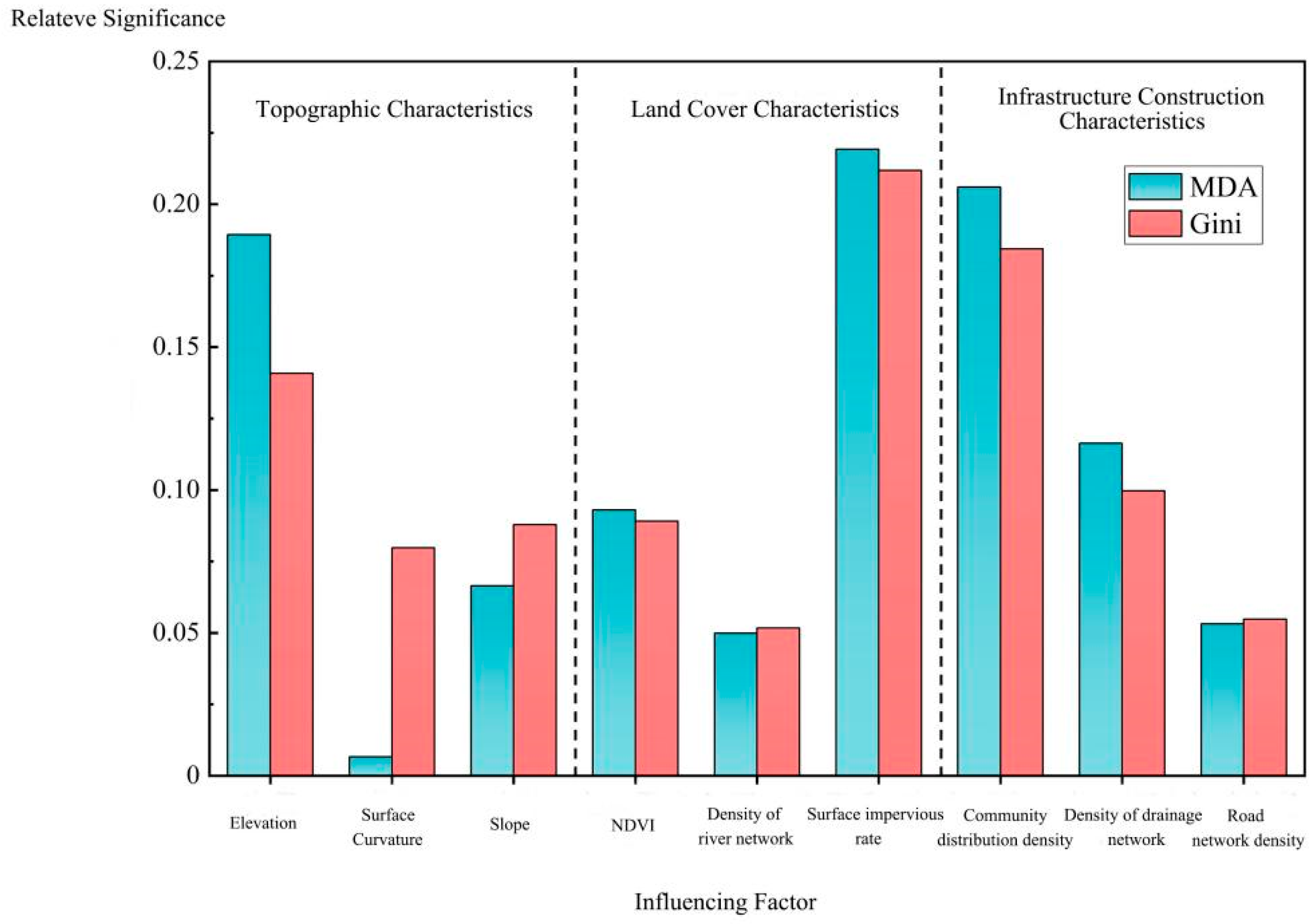
- Upon comprehensive consideration, it has been discovered that with regard to both the spatial layout of urban waterlogging incidents and the occurrence of such waterlogging incidents, the surface impervious rate exerts the most significant impact. Concurrently, three other influencing factors, namely the drainage pipe network density, community density (which can be regarded as population density), and elevation, also demonstrate considerable influence. When it comes to the interaction detection between any two factors, the interactive influences among the surface impervious rate, drainage pipe network density, road density, and elevation on the waterlogging within the study area are all rather substantial. In contrast, the influencing factors of river network density and curvature have relatively feeble influences.
- Based on the random forest model for the division of waterlogging sensitivity areas in the study area, it was found that the areas with high waterlogging sensitivity highly coincided with the areas where waterlogging points were densely distributed in terms of spatial distribution, accounting for 7.54% of the total area of the study area. In these areas, infrastructure construction was carried out earlier, the terrain was low-lying, the surface impervious rate was high, the density of community buildings was large, and the drainage capacity was poor. As a result, waterlogging was prone to occur in such areas.
Author Contributions
Funding
Institutional Review Board Statement
Informed Consent Statement
Data Availability Statement
Conflicts of Interest
References
- Li, C.; Cheng, X.; Li, N.; Du, X.; Yu, Q.; Kan, G. A Framework for Flood Risk Analysis and Benefit Assessment of Flood Control Measures in Urban Areas. Int. J. Environ. Res. Public Health 2016, 13, 787. [Google Scholar] [CrossRef] [PubMed]
- Wu, Q. Urban Flood Disaster Risks and Disaster Mitigation Countermeasures in China in the 21st Century. J. Catastrophology 1998, 13, 6. (In Chinese) [Google Scholar]
- Zhang, J.; Wang, Y.; Liu, C.; He, R. Discussion on Urban Flooding and Prevention and Control Standards in China. J. Hydroelectr. Eng. 2017, 36, 6. (In Chinese) [Google Scholar]
- Zhang, H.; Yang, J.; Li, L.; Shen, D.; Dong, S. Measuring the resilience to floods: A comparative analysis of key flood control cities in China. Int. J. Disaster Risk Reduct. 2021, 59, 102248. [Google Scholar] [CrossRef]
- Alexander, D.E. Resilience and disaster risk reduction: An etymological journey. Nat. Hazards Earth Syst. Sci. 2013, 13, 2707–2716. [Google Scholar] [CrossRef]
- Salvadore, E.; Bronders, J.; Batelaan, O. Hydrological modelling of urbanized catchments: A review and future directions. J. Hydrol. 2015, 529, 62–81. [Google Scholar] [CrossRef]
- Lee, C.S.; Ho, H.Y.; Lee, K.T.; Wang, Y.C.; Guo, W.D.; Chen, Y.C.; Hsiao, L.F.; Chen, C.H.; Chiang, C.C.; Yang, M.J. Assessment of sewer flooding model based on ensemble quantitative precipitation forecast. J. Hydrol. 2013, 506, 101–113. [Google Scholar] [CrossRef]
- Office of State Flood Control and Drought Relief Headquarters; Ministry of Water Resources of the People’s Republic of China. China Flood and Drought Disaster Bulletin 2017; Ministry of Water Resources of the People’s Republic of China: Beijing, China, 2018. (In Chinese) [Google Scholar]
- Meng, Y.; Wang, X. Sustainable Design of Stormwater Landscapes in Sponge City Construction. Ecol. Econ. 2018, 34, 5. (In Chinese) [Google Scholar]
- Ahiablame, L.M.; Engel, B.A.; Chaubey, I. Effectiveness of Low Impact Development Practices: Literature Review and Suggestions for Future Research. Water Air Soil Pollut. 2012, 223, 4253–4273. [Google Scholar] [CrossRef]
- Jarden, K.M.; Jefferson, A.J.; Grieser, J.M. Assessing the effects of catchment-scale urban green infrastructure retrofits on hydrograph characteristics. Hydrol. Process. 2015, 30, 1536–1550. [Google Scholar] [CrossRef]
- Gaitan, S.; Veldhuis, J.A.E.T. Opportunities for multivariate analysis of open spatial datasets to characterize urban flooding risks. PIAHS 2015, 370, 9–14. [Google Scholar] [CrossRef]
- Yu, H.; Zhao, Y.; Fu, Y. Optimization of Impervious Surface Space Layout for Prevention of Urban Rainstorm Waterlogging: A Case Study of Guangzhou, China. Int. J. Environ. Res. Public Health 2019, 16, 3613. [Google Scholar] [CrossRef]
- Huang, T.; Chen, J.; Huang, F.; Su, Z. A Study of Urban Waterlogging Characteristics in Pearl River Delta Region Based on GIS. J. Guangdong Univ. Technol. 2017, 34, 24–30. [Google Scholar]
- Schmitt, T.G.; Thomas, M.; Ettrich, N. Analysis and modeling of flooding in urban drainage systems. J. Hydrol. 2004, 299, 300–311. [Google Scholar] [CrossRef]
- Yong-Chao, Z.; Tian, L.I. Design and Safety Assessment of Conduits in Buffering Stormwater Drainage System. Hunan Daxue Xuebao/J. Hunan Univ. Nat. Sci. 2008, 22, 199–205. [Google Scholar]
- Xu, H. Analysis of Impervious Surface and its Impact on Urban Heat Environment using the Normalized Difference Impervious Surface Index (NDISI). Photogramm. Eng. Remote Sens. 2010, 76, 557–565. [Google Scholar] [CrossRef]
- Marsalek, J.; Chocat, B. International Report: Stormwater management. Water Sci. Technol. 2002, 46, 1–17. [Google Scholar] [CrossRef] [PubMed]
- Wong, T.; Chiew, F.; Mcmahon, T.; Duncan, H. Urban Drainage Maintenance and Management Issues in Arid and Semiarid Regions; The United Nations Educational, Scientific and Cultural Organization: Paris, France, 2001. [Google Scholar]
- Gaitan, S.; Ten Veldhuis, M.C.; Nick, V.D.G. Spatial Distribution of Flood Incidents Along Urban Overland Flow-Paths. Water Resour. Manag. 2015, 29, 3387–3399. [Google Scholar] [CrossRef]
- Mejia, A.I.; Moglen, G.E. Impact of the spatial distribution of imperviousness on the hydrologic response of an urbanizing basin. Hydrol. Process. 2010, 24, 3359–3373. [Google Scholar] [CrossRef]
- Du, S.; Shi, P.; Van Rompaey, A.; Wen, J. Quantifying the impact of impervious surface location on flood peak discharge in urban areas. Nat. Hazards 2015, 76, 1457–1471. [Google Scholar] [CrossRef]
- Yu, H.; Zhao, Y.; Fu, Y.; Li, L. Spatiotemporal Variance Assessment of Urban Rainstorm Waterlogging Affected by Impervious Surface Expansion: A Case Study of Guangzhou, China. Sustainability 2018, 10, 3761. [Google Scholar] [CrossRef]
- Li, Z.; He, W.; Cheng, M.; Hu, J.; Yang, G.; Zhang, H. SinoLC-1: The first 1-m resolution national-scale land-cover map of China created with the deep learning framework and open-access data. Earth Syst. Sci. Data Discuss. 2023, 15, 4749–4780. [Google Scholar] [CrossRef]
- Liu, W.; Zhang, X.; Feng, Q.; Yu, T.; Engel, B.A. Analyzing the impacts of topographic factors and land cover characteristics on waterlogging events in urban functional zones. Sci. Total Environ. 2023, 904, 166669. [Google Scholar] [CrossRef] [PubMed]
- Liu, F.; Liu, X.; Xu, T.; Yang, G.; Zhao, Y. Driving Factors and Risk Assessment of Rainstorm Waterlogging in Urban Agglomeration Areas: A Case Study of the Guangdong-Hong Kong-Macao Greater Bay Area, China. Water 2021, 13, 770. [Google Scholar] [CrossRef]
- Berndtsson, R.; Becker, P.; Persson, A.; Aspegren, H.; Tussupova, K. Drivers of changing urban flood risk: A framework for action. J. Environ. Manag. 2019, 240, 47–56. [Google Scholar] [CrossRef]
- Li, Q.; Li, X.; Gong, Z.; Qin, Q.; Zhang, B. Analysis on the Temporal and Spatial Patterns and Causes of Waterlogging in the Central Urban Area of Lanzhou City. Remote Sens. Technol. Appl. 2023, 38, 935–944. (In Chinese) [Google Scholar]
- He, P.; Liu, D.; Lu, S.; He, X.; Li, Y.; Yang, L.; Lin, J. Analysis of Influencing Factors and Risk Assessment of Waterlogging in Shenzhen Based on the Maximum Entropy Model. Prog. Geogr. 2022, 41, 1868–1881. (In Chinese) [Google Scholar] [CrossRef]
- Fang, D. Research on the Influencing Factors of Population Distribution in Guangxi Based on the Random Forest Model and Geodetector. Master’s Thesis, Nanning Normal University, Nanning, China, 2020. (In Chinese). [Google Scholar]
- Wang, J.; Xu, C. Geodetector: Principles and Prospects. Acta Geogr. Sin. 2017, 72, 116–134. (In Chinese) [Google Scholar]
- Wang, J.-F.; Li, X.-H.; Christakos, G.; Liao, Y.-L.; Zhang, T.; Gu, X.; Zheng, X.-Y. Geographical Detectors-Based Health Risk Assessment and its Application in the Neural Tube Defects Study of the Heshun Region, China. Int. J. Geogr. Inf. Sci. 2010, 24, 107–127. [Google Scholar] [CrossRef]
- Zheng, J. Research on the Spatial Pattern and Driving Mechanism of Waterlogging in Karst Mountainous Cities. Master’s Thesis, Guizhou Normal University, Guiyang, China, 2023. (In Chinese). [Google Scholar]
- Tian, Z.; Yin, C.; Wang, X. Dynamic Assessment of the Ecological Environment and Analysis of Driving Factors in the Poyang Lake Basin. Environ. Sci. 2023, 44, 816–827. (In Chinese) [Google Scholar]
- He, R.; Lu, H.; Jin, Z.; Qin, Y.; Yang, H.; Liu, Z.; Yang, G.; Xu, J.; Gong, X.; Zhao, Q. Construction of a Forest Fire Occurrence Prediction Model and Driving Factors in Southwest China Based on the Random Forest Algorithm. Acta Ecol. Sin. 2023, 43, 9356–9370. [Google Scholar]
- Tang, X.; Li, J.; Liu, W.; Yu, H.; Wang, F. A method to increase the number of positive samples for machine learning-based urban waterlogging susceptibility assessments. Stoch. Environ. Res. Risk Assess. 2021, 36, 2319–2336. [Google Scholar] [CrossRef]
- Du, S.; Zhang, J.; Han, Z.; Gong, M. Prediction of Armed Conflict Risk and Analysis of Influencing Factors at the “Grid-Month” Scale Based on the Random Forest Model: A Case Study of the Indo-China Peninsula. J. Geo-Inf. Sci. 2023, 25, 2026–2038. (In Chinese) [Google Scholar]
- Wu, M.; Wu, Z.; Ge, W.; Wang, H.; Jiang, M. Identification of sensitivity indicators of urban rainstorm flood disasters: A case study in China. J. Hydrol. 2021, 599, 126393. [Google Scholar] [CrossRef]
- Yan, C. Multi-objective Optimization Research on the Regional Groundwater Pollution Monitoring Well Network—A Case Study of Pinggu Plain Area. China Univ. Geosci. 2021. (In Chinese) [Google Scholar]
- Lu, X.; Zhang, C.; Huang, J.; Tian, Y.; Wang, X. Analysis and Evaluation of Influencing Factors for Rainstorm and Flood Sensitivity—A Case Study of Anyi County in Jiangxi Province. J. Catastrophology 2021, 36, 223–229. (In Chinese) [Google Scholar]





| Data | Data Type | Data Year | Data Source |
|---|---|---|---|
| Waterlogging accumulation points | Text file | 2015–2023 | City water authority, mainstream media |
| Topographic data | Raster | 2020 | USGS (https://www.usgs.gov/) |
| High-resolution remote sensing image | Satellite imagery | 2020 | Geospatial Data Cloud (https://www.gscloud.cn/) |
| River data | Vector | 2020 | Water Affairs Department |
| Administrative divisions | Vector | 2020 | National Geomatics Center of China (https://www.ngcc.cn/) |
| Road data | Vector | 2023 | National Earth System Science Data Center(http://www.geodata.cn/) |
| Administrative village data | Text file | 2022 | National Bureau of Statistics (http://www.stats.gov.cn/) |
| Impervious surface | Vector | 1985–2020 | Reference [24] |
| Drainage pipe network data | Vector | 2020 | Water Affairs Department |
| Interactive Effect | Judgment Basis |
|---|---|
| Nonlinear enhancement | < |
| Nonlinear enhancement of a single factor | < |
| Enhancement of dual factors | > |
| Mutually independent | = |
| Nonlinear enhancement | > |
| (a) Topographic feature factor | |||
| Influencing Factor | Topographic Feature Factor | ||
| Elevation | Curvature | Slope | |
| 0.0665 | 0.0018 | 0.0198 | |
| (b) Land cover characteristic factor | |||
| Influencing factor | Land Cover Characteristic Factor | ||
| Vegetation Coverage | Density of River Network | Surface Impervious Rate | |
| 0.0634 | 0.0046 | 0.3188 | |
| (c) Characteristic factors of infrastructure construction | |||
| Influencing Factor | Characteristic Factors of Infrastructure Construction | ||
| Community Distribution Density | Density of Drainage Network | Road Network Density | |
| 0.1351 | 0.2268 | 0.1987 | |
Disclaimer/Publisher’s Note: The statements, opinions and data contained in all publications are solely those of the individual author(s) and contributor(s) and not of MDPI and/or the editor(s). MDPI and/or the editor(s) disclaim responsibility for any injury to people or property resulting from any ideas, methods, instructions or products referred to in the content. |
© 2025 by the authors. Licensee MDPI, Basel, Switzerland. This article is an open access article distributed under the terms and conditions of the Creative Commons Attribution (CC BY) license (https://creativecommons.org/licenses/by/4.0/).
Share and Cite
Yang, H.; Ning, W.; Wang, Z.; Sun, X. Determination and Sensitivity Analysis of Urban Waterlogging Driving Factors Based on Spatial Analysis Method. Sustainability 2025, 17, 2785. https://doi.org/10.3390/su17062785
Yang H, Ning W, Wang Z, Sun X. Determination and Sensitivity Analysis of Urban Waterlogging Driving Factors Based on Spatial Analysis Method. Sustainability. 2025; 17(6):2785. https://doi.org/10.3390/su17062785
Chicago/Turabian StyleYang, Haiyan, Wang Ning, Zhe Wang, and Xiaobo Sun. 2025. "Determination and Sensitivity Analysis of Urban Waterlogging Driving Factors Based on Spatial Analysis Method" Sustainability 17, no. 6: 2785. https://doi.org/10.3390/su17062785
APA StyleYang, H., Ning, W., Wang, Z., & Sun, X. (2025). Determination and Sensitivity Analysis of Urban Waterlogging Driving Factors Based on Spatial Analysis Method. Sustainability, 17(6), 2785. https://doi.org/10.3390/su17062785


