Article

Developing a Novel Robust Model to Improve the Accuracy of River Ecosystem Health Assessment in the Qinghai–Tibet Plateau

1
State Key Laboratory of Hydraulics and Mountain River Engineering, Sichuan University, Chengdu 610065, China
2
State Key Laboratory of Hydrology-Water Resources and Hydraulic Engineering, Nanjing Hydraulic Research Institute, Nanjing 210029, China
3
Key Laboratory of Integrated Regulation and Resource Development on Shallow Lake of Ministry of Education, College of Environment, Hohai University, Nanjing 210098, China
4
Collaborative Innovation Center of Sustainable Forestry in Southern China of Jiangsu Province, Nanjing Forestry University, Nanjing 210037, China
*
Authors to whom correspondence should be addressed.
Sustainability 2025, 17(5), 2041; https://doi.org/10.3390/su17052041
Submission received: 13 December 2024 / Revised: 11 February 2025 / Accepted: 19 February 2025 / Published: 27 February 2025

Abstract

:
River ecosystem health assessment (REHA) is crucial for sustainable river management and water security. However, existing REHA methodologies still fail to consider the multiple effects of input uncertainty, environmental stochasticity, and the decision-maker’s bounded rationality. Moreover, REHA studies primarily focused on plain areas, leaving the Qinghai–Tibet Plateau (QTP) understudied despite its ecosystems’ heightened fragility and complexity. To address these gaps, this study combined Pythagorean fuzzy sets with cloud modeling and proposed the Pythagorean fuzzy cloud (PFC) approach. Accordingly, a novel robust model (PFC-TODIM) was created by expanding the conventional TODIM method to the PFC algorithm. We provided an REHA indicator system tailored to the distinctive characteristics in the QTP, leveraging multisource data. River ecosystem health, driving mechanisms, and potential threats were investigated in the Lhasa River (LR) using the PFC-TODIM model. Results showed that the created model effectively took multiple uncertainties into consideration, thereby improving the REHA accuracy and robustness. In the LR, health conditions demonstrated substantial spatial disparities. Sampling sites of 28%, 48%, and 24% were subhealthy, healthy, and excellent, respectively. Findings showed that anthropogenic factors, such as dams, urban development, and fish release adversely affect river health and should be properly managed.

1. Introduction

Rivers, integral to the hydrological cycle, serve as primary conduits for water resources and sustain most biologically diverse freshwater ecosystems on Earth [1]. These complex systems encompass intricate interactions among microorganisms, flora, fauna, and their habitats while simultaneously providing crucial ecological services [2]. SDG 6, focused on “Clean Water and Sanitation”, emphasized sustainable water resource management, and played a pivotal role in achieving water security and fostering economic growth [3]. The concept of river ecosystem health has evolved considerably over recent decades, with scholars refining its definition and scope [4,5]. Contemporary scholarly consensus posits that river ecosystem health encompasses both the maintenance of ecological structure and function and the fulfillment of societal requirements [6]. Currently, a compelling conceptualization expands this understanding by integrating non-ecological functions with ecosystem integrity, thus offering a more holistic framework for assessing and defining river ecosystem health.
River ecosystem health assessment (REHA) is a powerful tool for evaluating riverine system integrity and plays a vital role in achieving SDG6 and ensuring water security. REHA methodologies have evolved from single-factor models [7] and prediction techniques [8] to more comprehensive multi-attribute decision-making (MADM) frameworks. These MADM approaches integrate diverse evaluation factors, including biological, chemical, physical, and social parameters, to provide a holistic representation of river ecosystem health [9]. MADM offers valuable insights for the management and restoration of rivers. MADM techniques tailored to specific river characteristics and method capabilities have been proposed to assess river ecosystem health effectively [10]. These techniques primarily encompassed the multivariate statistical analysis, redundancy analysis, analytic hierarchy process, artificial neural network, fuzzy sets, cloud model, and hybrid approaches combining multiple methodologies [8,11,12].
The Qinghai–Tibet Plateau (QTP), characterized by its unparalleled elevation, intricate geographical features, and severe climatic conditions, is crucial for China’s water resources and ecological security [13]. River ecosystems in this region exhibit inherent vulnerability to external perturbations, largely due to their unique geographical and climatic context [14]. The remote and sparsely populated nature of certain QTP areas poses significant challenges for data acquisition and monitoring. Moreover, the synergistic impacts of global climate change, anthropogenic interventions, and the inherent vulnerability of plateau river ecosystems exacerbate the variability in monitoring data [15]. Consequently, REHA studies in the QTP, frequently constrained by limited sample sizes and fragmentary historical datasets, are inherently prone to substantial uncertainties [9]. Most existing multi-criteria decision-making methods assume that decision-makers are entirely rational. However, in real-life situations, due to the complexity of the subject under study and the cognitive limitations of decision-makers, decision-makers often exhibit psychological behaviors such as reference dependence and loss aversion when making decisions, reflecting their bounded rationality [12]. To ensure sustainable river management in this region, it is imperative to develop robust models capable of performing REHA under conditions of input uncertainty and environmental stochasticity.
Despite significant progress in REHA methodologies over recent decades, current studies in this field still struggle to fully account for the combined effects of input uncertainty, environmental stochasticity, and decision-makers’ bounded rationality on REHA outcomes [9,12]. Traditional methods primarily focused on addressing either randomness or fuzziness in REHA, neglecting their simultaneous occurrence. Moreover, existing research predominantly concentrated on plains regions, while the QTP remains comparatively understudied. The unique vulnerability of river ecosystems in the QTP necessitates the development of specialized REHA methods tailored to specific environments. The inherent fragility and heightened uncertainty characteristic of QTP ecosystems introduce both random and fuzzy elements into the REHA process. To address these complexities, an integrated approach combining fuzzy set theory, cloud modeling, and the TODIM method offers a promising solution. Fuzzy set theory effectively handles imprecise decision-making elements, while cloud modeling is suited for multi-attribute decisions involving randomness. The TODIM (the acronym in Portuguese for interactive and multi-criteria decision-making) approach, grounded in prospect theory, incorporates decision-makers’ bounded rationality into the MADM process.
To address the aforementioned challenges, this study proposed a novel approach integrating Pythagorean fuzzy sets (PFSs) and cloud modeling to create the Pythagorean fuzzy cloud (PFC) concept. The analytic hierarchy process with particle swarm optimization (AHP-PSO) was employed to calculate indicator weights. Accordingly, this study developed a novel PFC-TODIM framework by extending the conventional TODIM approach to the PFC environment. This integrated framework effectively considered multiple uncertainties (input uncertainty, environmental stochasticity, and decision-makers’ bounded rationality), thereby improving the accuracy of river ecosystem health assessment and model robustness. We provided a holistic indicator system tailored to the distinctive ecological characteristics of the QTP, leveraging multisource data. The Lhasa River (LR) served as a representative case study; we applied the PFC-TODIM framework to assess river ecosystem health and identify potential threats unique to plateau rivers.
The primary goals in this study are to (i) explore a novel robust model to investigate REHA under multiple uncertainties, (ii) disclose the temporal–spatial distribution and driving mechanisms of the river health status in the QTP, and (iii) make recommendations for river management in ecologically fragile regions based on this study. The research transcends conventional REHA by ingeniously integrating sophisticated uncertainty analysis methodologies, thereby facilitating a nuanced, comprehensive epistemological framework for comprehending river ecosystem dynamics within geographically challenging environments. By employing a robust, multi-dimensional modeling approach, this study advances ecological research paradigms, offering critical methodological and conceptual innovations for environmental management and conservation strategies in ecologically fragile, high-altitude landscapes.

2. Materials and Methods

2.1. Study Area and Sampling Sites

As one of the world’s highest rivers, the Lhasa River (LR) extends 551 km with an elevation exceeding 3500 m, is situated in the southwestern Qinghai–Tibet Plateau (QTP) (Figure 1). The LR basin, encompassing an area of 32,588 km2, serves as Tibet’s demographic and economic focal point [16]. The LR basin is replenished by a combination of meltwater, precipitation, and groundwater infiltration [17]. This region is characterized by a semi-arid monsoon climate, with a relatively cool temperature (5.3 °C) and dry climate (precipitation of 400 mm) [18]. A warm, humid air mass from the Indian Ocean influences the LR basin, which is characterized by concentrated summer precipitation, minimal annual temperature fluctuations, and substantial variations in daytime temperatures [10].
In the study area, the topography is distinguished by extreme relief, and the natural vegetation consists predominantly of grasslands and sparsely vegetated zones [9,16]. The main land use types include waters (3.811%), croplands (0.881%), grasslands (56.113%), forests (9.561%), glaciers (1.724%), urban built-up areas (0.483%), and barren and sparsely vegetated areas (27.427%) [17]. Anthropogenic disturbances are primarily concentrated in the lower reaches of the Lhasa River (LRLR), where altitudes are below 4200 m. There are two major hydropower plants situated in the middle reaches of the Lhasa River (MRLR), the Zhikong and the Pangduo plants. There is relatively little human disturbance along the upper reaches of the Lhasa River (URLR), while reservoir construction has an impact on the MRLR, and urbanization has an impact on the LRLR (Figure 1). A total of 25 strategic sampling locations are selected for this study, considering the regional geographic features and ecological functions. The specific sampling sites are shown in (Figure 1c).

2.2. Data Collection and Processing

2.2.1. Indicator System

This research adopted a holistic methodology to establish the REHA indicator framework. The initial phase of indicator identification leveraged the Delphi and bibliometric methods, which were subsequently tailored to reflect the distinctive river ecosystems of the QTP [9,12]. To guarantee the independence of the indicators, Spearman correlation analysis was applied, removing those with high interdependency [19]. Within the LR framework, the system integrated both ecological integrity, encompassing habitat structure, water quantity and quality, and aquatic organisms, and social service functions. The habitat integrity of LR was examined by analyzing its structural components, which included river connectivity (C1), riparian naturalness (C2), land development (C3), and natural wetland (C4). Ecosystem resilience was analyzed through water quantity and quality parameters, including ecological flow satisfaction (C5), river flow regime (C6), oxygen-consuming organics (C7), and heavy metals (C8). Biological integrity and diversity were examined through the composition of aquatic organisms, specifically phytoplankton (C9), macroinvertebrates (C10), fish (C11), and waterbirds (C12). The value and functionality of riverine ecosystem services were quantified using metrics for flood control (C13), water supply (C14), water utilization (C15), and public satisfaction (C16). These indicators were calculated and classified followed the “Technical Guideline for River Health Assessment in China” (SL/T 793-2020) [20].

2.2.2. Sample Collection and Testing

In this study, field sampling and monitoring were launched at 25 monitoring sites during the flood season (June) and the non-flood season (December) in 2021 to investigate the LR’s health status. Due to the prevalence of natural hazards in this region, field surveys included enhanced safety protocols in remote areas. Sampling sites were geolocated using portable GPS units. At each site, water samples (50 L) were acquired from three depths: surface, 0.5 m, and 1 m [21]. Following filtration through a 25 μm screen, 100 mL aliquots were preserved to conduct subsequent processes. Rotifera and Protozoa were fixed using 1.5% Lugol’s solution, while Copepoda and Cladocera were preserved in 4% formaldehyde. Following 48 h of sedimentation, we extracted 30 mL of supernatant and stored the sediment samples at 4 °C before transporting them to the laboratory [19]. Fish specimens were collected from various river segments using nets and cages. Ichthyologists documented their biological parameters, including species, length, age, weight, and sex [22]. Ornithologists conducted waterbird surveys along the LR, utilizing binoculars for species identification and enumeration, supplemented with photographic documentation. To assess the public perception of LR health, 200 questionnaires were administered to local people through both on-site and online surveys. The survey data were then subsequently compiled. Zooplankton and phytoplankton samples were subjected to microscopic analysis in laboratory settings.

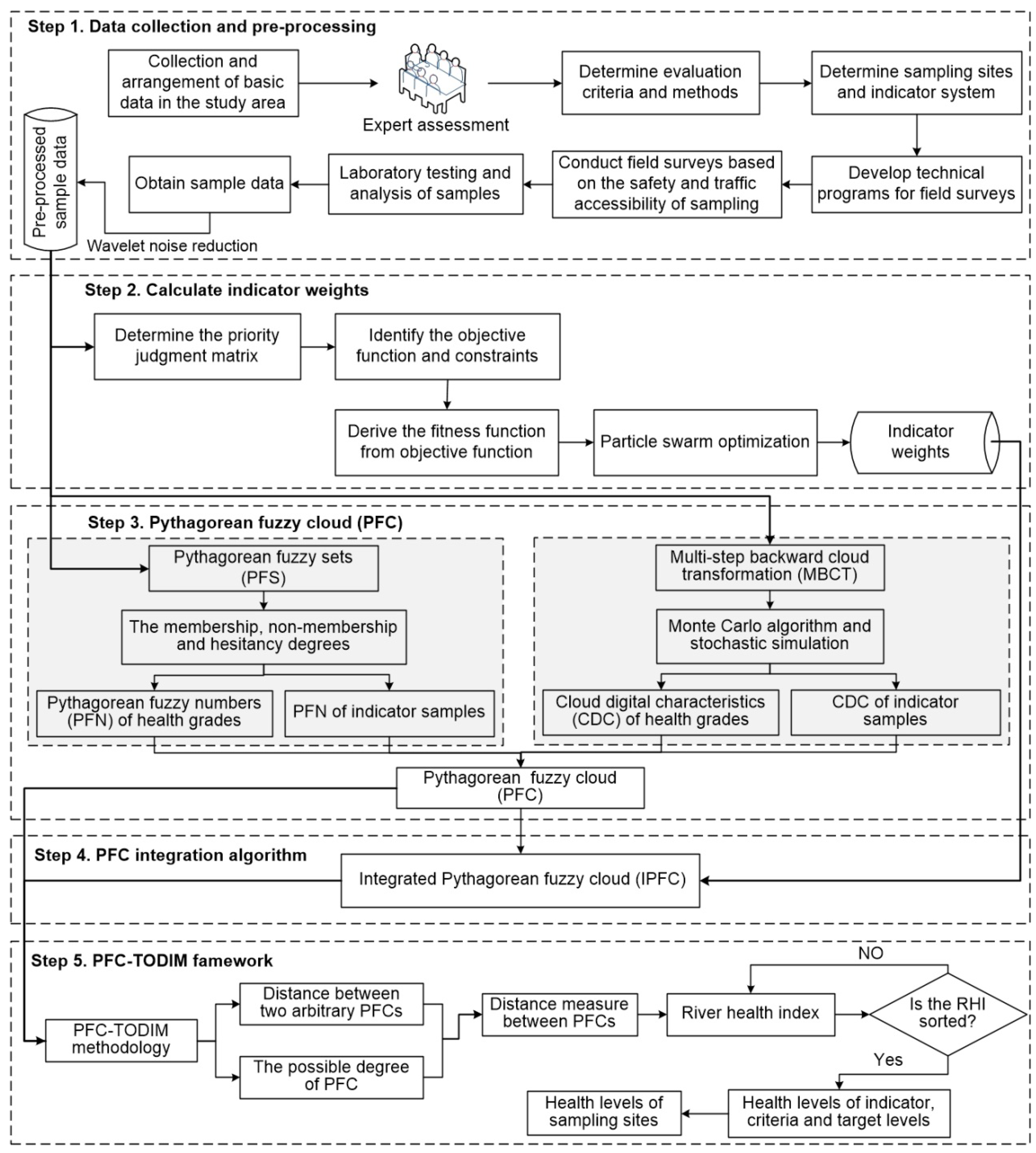
2.3. Hybrid Decision-Making Model

To enhance the robustness of the results against environmental variabilities, the raw data were preprocessed using the wavelet noise reduction method [10]. The analytic hierarchy process with particle swarm optimization (AHP-PSO) was employed to calculate indicator weights. This study proposed a novel approach integrating Pythagorean fuzzy sets (PFSs) and cloud modeling to create the Pythagorean fuzzy cloud (PFC) concept [21]. Accordingly, a novel PFC-TODIM model was raised by integrating the conventional TODIM approach into the PFC environment. This integrated framework effectively considered multiple uncertainties (input uncertainty, environmental stochasticity, and decision-makers’ bounded rationality), thereby improving the accuracy of river ecosystem health assessment and model robustness. We provided a holistic indicator system tailored to the ecological functions and distinctive characteristics in the QTP, leveraging multisource data. The Lhasa River served as a representative case study; we applied the PFC-TODIM framework to assess river ecosystem health and identify potential threats and underlying mechanisms unique to plateau rivers. The calculation framework and process are shown in Figure 2.

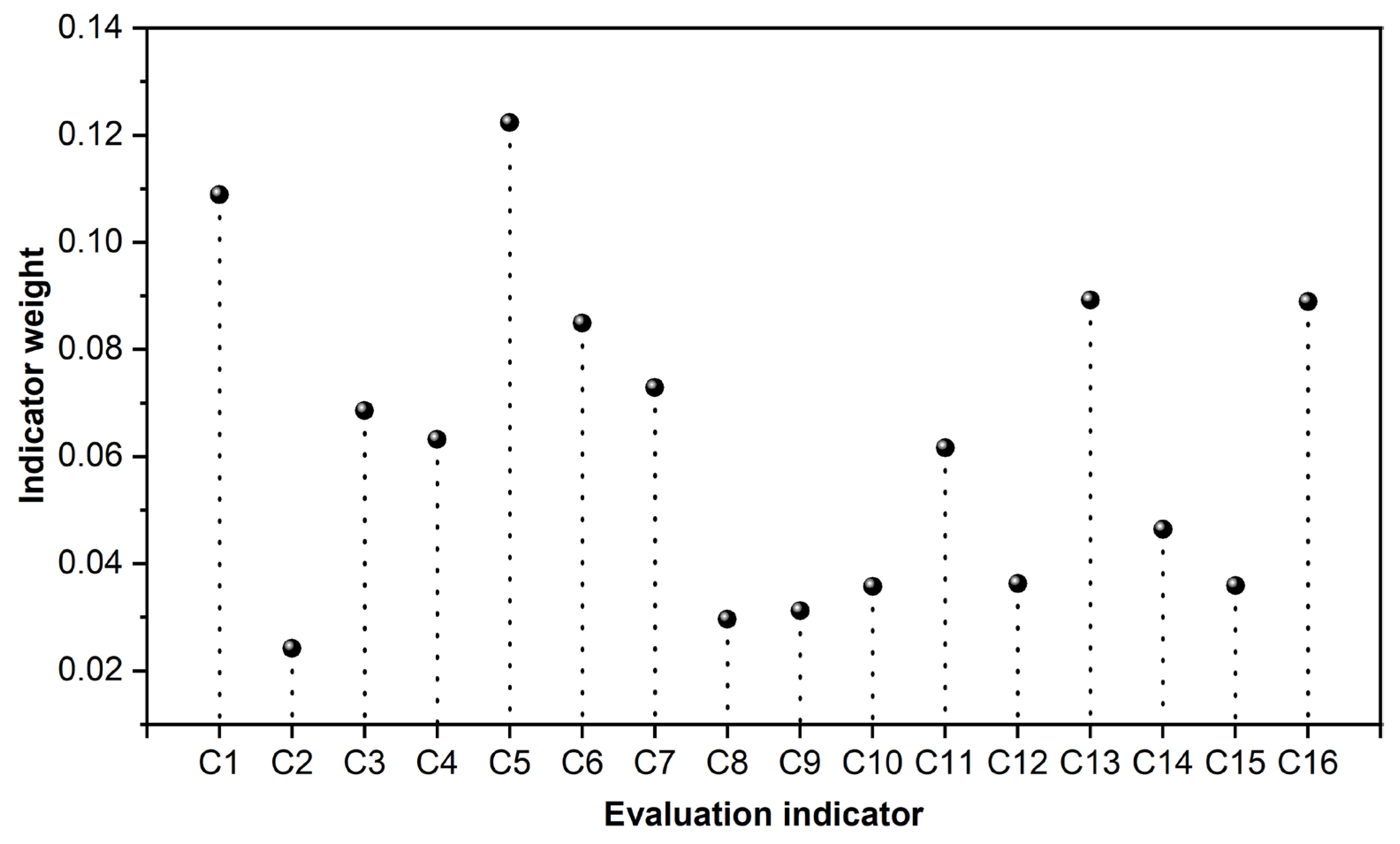
2.3.1. Indicator Weights

AHP is an effective approach to calculate the weight of the evaluation object [23]. However, the AHP method has drawbacks, such as imprecise prioritization and judgment results [24]. The AHP-PSO can effectively deal with the above deficiencies [9].
Assuming X = x 1 , x 2 , , x n is the preprocessed sample data, B = ( β ij ) n × n is the priority judgment matrix, and the weight of the ith indicator is w i ( i = 1 , 2 , , n ) , it fulfills w i > 0 and i = 1 n w i = 1 . The weight vector wi is
w i = 1 n j = 1 n β ij i n β ij , i , j = 1 , 2 , n
If matrix B completed the consistency test, Equation (2) will be used to compute the consistency ratio.
CR = 1 RI λ max n ( n 1 ) λ max = 1 n i = 1 n β ij w i w i
CR is the consistency ratio, and RI is the random index.
Distances between consistent matrices were optimized using a nonlinear optimization equation [21].
Min i = 1 n j = 1 n β ij w i w j 2 s . t .   w i > 0 i = 1 n w i = 1
The optimized fitness function F(x) was as follows:
F ( x ) = i = 1 n j = 1 n β ij w i w j 2 1 / 2
The AHP-PSO algorithm was configured with 40 particle swarms, individual and global learning factors set to 2, and an inertia coefficient of 1. The iteration ranges were defined as 1000 (minimum) and 3000 (maximum), respectively. The parameter Ex represented the health status of the river ecosystem, with higher values indicating better ecological conditions. As PFCs shifted to the right, cloud droplets exhibited increased cohesion, leading to larger PFC peaks and a transition in health levels from poor to optimal. Consequently, higher health grades corresponded to elevated health scores and reduced randomness.

2.3.2. Pythagorean Fuzzy Cloud

This study developed the Pythagorean fuzzy sets (PFSs) to deal with hesitation concerns more effectively [25].
P = < x , P μ P ( x ) , v P ( x ) > x X
where μ P ( x ) and v P ( x ) are the membership and non-membership degrees, and they follow ( μ P ( x ) ) 2 + ( v P ( x ) ) 2 1 . Similarly, π P ( x ) = 1 ( μ P ( x ) ) 2 ( v P ( x ) ) 2 is the hesitancy degree of x to P, and μ P ( x ) , v P ( x ) is the Pythagorean fuzzy number (PFN).
Assuming the universe set is U and the qualitative concept within U is η , x represents a random implementation of η , which fulfills x ~ N E x , En 2 ,   En ~ N En , He 2 . The certainty degree that x belongs to η is defined as f ( x ) , with the range of [0, 1].
f ( x ) = exp ( x E x ) 2 2 En 2
The cloud model expressed the distribution of x within U, and the cloud droplet (x, f(x)) is the dispersed particle. CDC integrates quantitative data and qualitative analysis, appropriately dealing with uncertainties [10]. CDC has three key parameters, namely expectation (Ex), entropy (En), and hyper-entropy (He). Ex is the expectation distribution of cloud droplets in U [26]. En is the acceptable range of cloud droplets for concept η , which reflects randomness [27]. He is the cohesion of cloud droplets and reflects the uncertainty of En [24]. Following the formula above, we can calculate the CDCs of river health grades.
Ex = U min + U max / 2 En = U max U min / 6 He = δ · E n
where expectation, entropy, and hyper-entropy are represented by Ex, En, and He, respectively. There are two thresholds for grades, Umax and Umin. δ denotes the cohesion adjustment factor for cloud droplets, which is set to 0.1 [12].
The multi-step backward cloud transformation (MBCT) can determine the CDC values of indicator samples [9]. m groups of samples were confirmed from sample data X = x 1 , x 2 , , x n using the Monte Carlo algorithm, and each group contained r samples. The estimator Ex was
Ex = 1 n i = 1 n x i
The sample variance of the kth group was
y k 2 = 1 r 1 j = 1 r x k j E x k 2 , k = 1 , 2 , , m
where Ex k = 1 r j = 1 r x k j is the corresponding sample mean, and y 1 , y 2 , , y k , , y m follow the normal distribution N En , He 2 .
The estimated values of En and He were from samples y 1 2 , y 2 2 , y k 2 , , y m 2 .
E n 2 = 1 2 4 E Y 2 2 2 D Y 2 H e 2 = E Y 2 E n 2
where E n 2 and H e 2 are the estimated values of En and He; D Y 2 = 1 m 1 k = 1 m y k 2 E Y 2 2 is the sample variance of y k 2 , and E Y 2 = 1 m k = 1 m y k 2 is the sample mean of y k 2 .
Accordingly, the Pythagorean fuzzy cloud (PFC) was proposed based on coupling the PFN and CDC. Equation (11) can obtain the certainty degree of PFC [21].
f p ( x ) = ψ exp ( x Ex ) 2 2 En 2
where f p ( x ) denotes the certainty degree of PFC, and ψ [ μ , 1 v 2 ] is the PFC adjustment coefficient associated with μ and v .
Supposing the arbitrary PFC is C i ( < E x i , μ i , v i > , E n i , H e i ) , the PFC vector is C = C 1 , C 2 , , C n , and the weight vector is w = w 1 , w 2 , , w n . The integrated Pythagorean fuzzy cloud (IPFC) is determined via Equation (12).
IPFC C 1 , C 2 , , C n = i = 1 n w i C i = < i = 1 n w i Ex i , i = 1 n w i μ i Ex i i = 1 n w i Ex i , i = 1 n w i v i Ex i i = 1 n w i Ex i > i = 1 n w i En i 2 , i = 1 n w i He i 2

2.3.3. PFC-TODIM Framework

C i ( < Ex i , μ i , v i > , En i , He i ) and C j ( < Ex j , μ j , v j > , En i , He j ) are arbitrary PFCs; C + < Ex + , μ + , v + > , En + , He + = < max 1 i n Ex i , max 1 i n μ i , min 1 i n v i > min 1 i n En i , min 1 i n He i is the positive ideal solution, and the distance formula are as follows:
d C i , C j = 1 E n i 2 + H e i 2 E n i 2 + H e i 2 · E n j 2 + H e j 2 ρ i Ex i 1 E n j 2 + H e j 2 E n j 2 + H e j 2 · E n i 2 + H e i 2 ρ j Ex j d C i , C + = 1 E n i 2 + H e i 2 E n i 2 + H e i 2 · E n + 2 + H e + 2 ρ i Ex i 1 E n + 2 + H e + 2 E n i 2 + H e i 2 · E n + 2 + H e + 2 ρ + Ex +
where d C i , C j is the distance between C i and C j ; ρ i = μ i + 1 v i 2 2 ; ρ j = μ j + 1 v j 2 2 ; d C i , C + is the distance between C i and C + , and ρ + = μ + + 1 ( v + ) 2 2 .
The possible degree of C i C j is identified using Equation (14) [12].
P ( C i C j ) = 1 d C i , C + d C i , C + + d C j , C +
where P ( C i C j ) denotes the possible degree of C i C j . If P ( C i C j ) 0.5 , then C i C j ; otherwise, C i < C j .
The TODIM approach integrates the incorporation of prospect theory and the limited rationality of the decision-makers [6]. The PFC-TODIM model can effectively investigate REHA with uncertainty [12]. The approach effectively coupled TODIM and PFC by extending the former into the PFC environment. The dominance degree of C i over C j under the conditional of attribute t was as follows:
φ t C i t , C j t = w t t = 1 n w t d C i t , C j t   , C i t > C j t 0   ,   C i t = C j t 1 θ t = 1 n w t w t d C i t , C j t   , C i t < C j t
where φ t C i t , C j t is the dominance degree of C i t over C j t ; w t is the weight, and d C i t , C j t is the distance between C i t and C j t . If 0 < θ < 1 , the losses are amplified; if θ > 1 , the losses are attenuated.
The overall dominance degree of C i over C j was as follows:
Φ C i , C j = t = 1 n φ t C i t , C j t ( i , j = 1 , 2 , , n )
RHI = j = 1 m Φ C i , C j min j = 1 m Φ C i , C j max j = 1 m Φ C i , C j min j = 1 m Φ C i , C j
where RHI is the river health index, and the health statuses can be obtained based on the sorted RHI values. A larger RHI value reflects a higher health level.

3. Results

3.1. Health Conditions Indicator Level

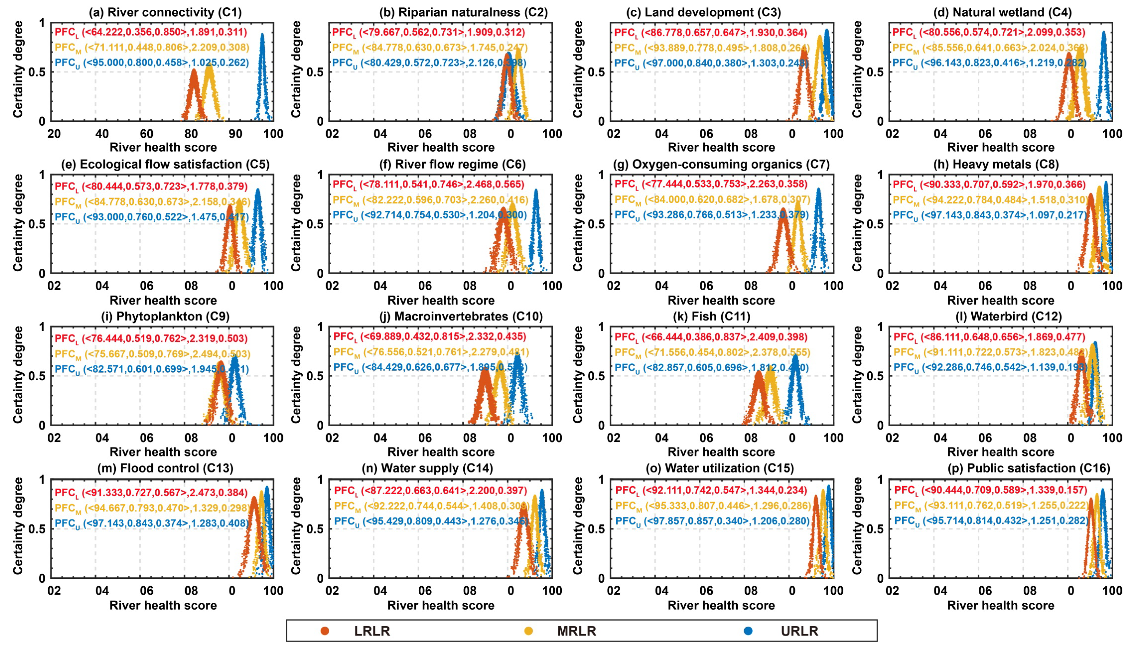
3.1.1. PFC of Evaluation Indicators

The weights and PFC diagram of the 16 evaluation indicators of the LR are shown in Figure 3 and Figure 4. Compared with the MRLR and the LRLR, the PFC in the URLR showed an obvious rightward shift trend, with higher peaks and more condensed cloud droplets. Accordingly, the health status in the LR was in the order of URLR > MRLR > LRLR. Among them, the Ex values of C1, C6, C7, C9, C10, and C11 were relatively low, which indicated that the average health scores are relatively low.
The smaller membership degree u and the larger non-membership degree v existed in the six indicators (C1, C6, C7, C9, C10, and C11), meaning that there was greater ambiguity in these indicators. En is the dispersion of cloud droplets and is used to reveal the randomness of the evaluation indicators. He elucidates the uncertainty of En, which can effectively reflect the cohesion among cloud droplets. The larger En and He are, the greater the randomness of the evaluation indicator is. Compared with the MRLR and the LRLR, the En and He in the URLR were smaller, indicating that the lower randomness and higher stability of indicators occurred in the URLR. There were larger En and He in the indicators C6, C9, C10, and C11, implying greater volatility and uncertainty.

3.1.2. Health Conditions of Evaluation Indicators

In the URLR, C2, C9, C10, and C11 were classified as healthy, while twelve indicators (C5, C13, C3, C14, C7, C16, C4, C6, C15, C12, C8, and C1) fell within the excellent category (Figure 5a). No indicators in the URLR were categorized as subhealthy, unhealthy, and sick. This indicated that the URLR maintained a favorable health status, and all indicators were in a good health level.
As shown in Figure 5b, the MRLR demonstrated an obvious deterioration in health status for C1, C9, and C11. The health levels decreased from the healthy state in the URLR to the subhealthy state in the MRLR. With the strengthening of human activities, C6, C5, C4, C12, C7, and C3 decreased from excellent to the healthy state. Presently, only C8, C14, C13, C15, and C16 maintained an excellent status. There were five, eight, and three indicators classified as excellent, healthy, and subhealthy, respectively. No indicator was classified as unhealthy or sick in the MRLR.
Compared to the MRLR and the URLR, the LRLR exhibited a marked decline in health status across all evaluation indicators (Figure 5c). The number of indicators classified as excellent had precipitously decreased to two (C15 and C16). The number of indicators in the healthy states remained consistent with the MRLR, reaching eight indicators (C4, C13, C2, C14, C5, C3, C12, and C8). Notably, the number of subhealthy indicators had increased from three in the MRLR to six in the LRLR (C11, C10, C6, C9, C1, and C7).
Overall, the URLR experienced relatively minimal anthropogenic disturbance, resulting in a superior health status compared to the MRLR and LRLR. A downward trend in the health levels was observed from the URLR to the LRLR. Notably, ten indicators consistently maintained a healthy or excellent status throughout the entire river sections. The non-ideal health status existed in the remaining six indicators. From the URLR to the LRLR, the number of indicators classified as excellent decreased from twelve to two, while those categorized as subhealthy increased from zero to six. In the URLR, MRLR, and LRLR, the health attainment rates of indicators during the study period were 100%, 81.25%, and 62.5%, respectively.

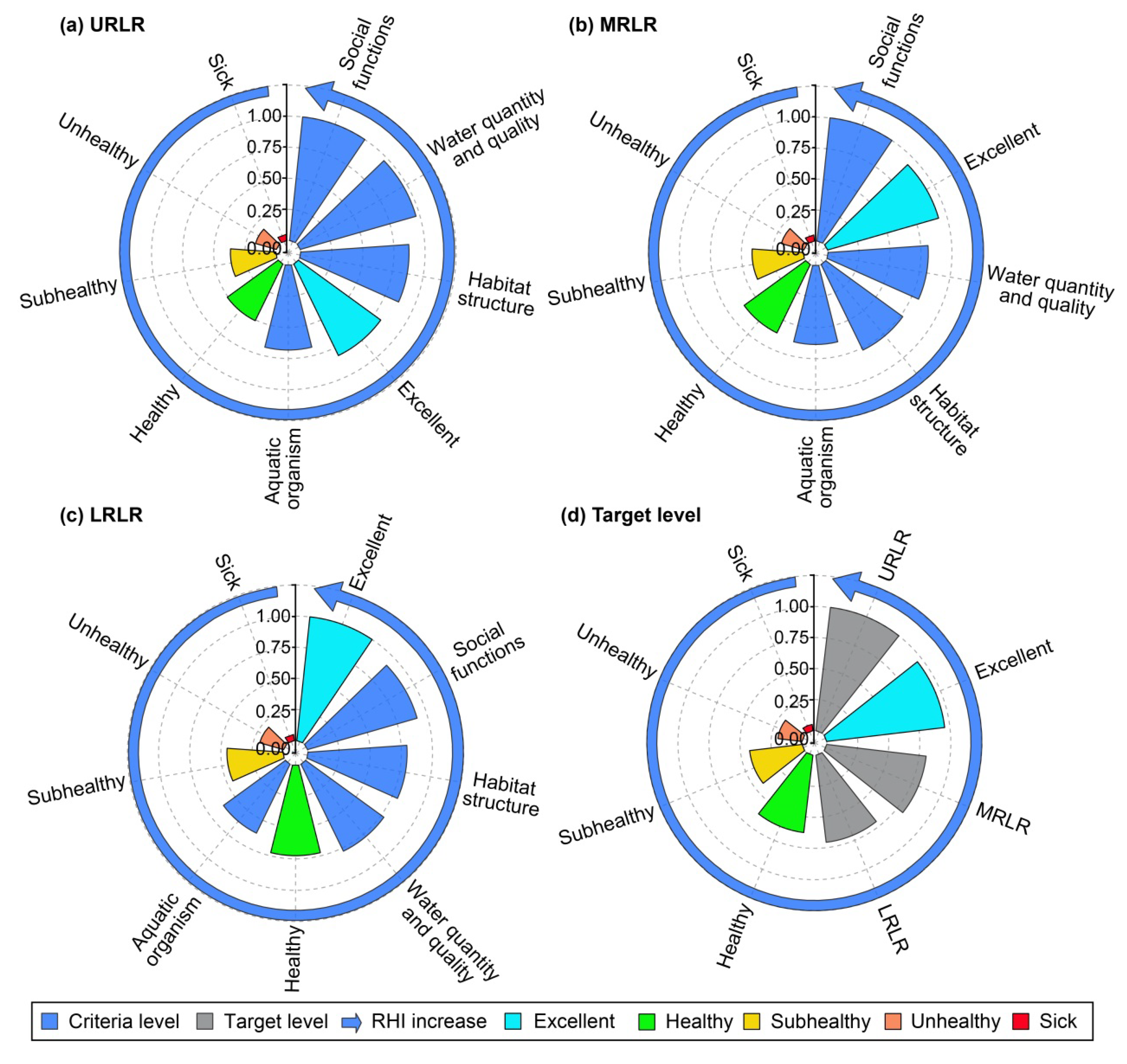
3.2. Health Conditions of Criteria and Target Levels

3.2.1. IPFC of Criteria and Target Levels

The values of parameter Ex were URLR > MRLR > LRLR, indicating that the average scores of river health decreased from URLR to LRLR. The parameters u and v exhibited the following trends: u in LRLR < u in MRLR < u in URLR, and v in URLR < v in MRLR < v in LRLR, respectively. This suggested that the degree of fuzziness in the criteria levels increased from the URLR to the LRLR. En reflects the dispersion of cloud droplets, while He elucidates the uncertainty of En. These parameters effectively represent the cohesion among cloud droplets and serve to the randomness of the criteria levels. The higher values of En and He correspond to greater randomness in the criteria-level data. Comparatively, the URLR exhibited lower En and He values across all criteria levels than the MRLR and LRLR. This indicated that the criteria levels in the URLR possessed lower randomness and higher stability.
The criteria levels of social functions in the URLR (Figure 6d) and of the aquatic organism in the LRLR (Figure 6c) demonstrated the highest and lowest Ex values, respectively, indicating the best and worst health levels. The cloud diagram of the aquatic organism exhibited a notably lower peak value and more dispersed cloud droplets compared to the other criteria levels. This characteristic suggested that the data in the criteria levels possessed greater randomness and fuzziness, reflecting an undesirable health status.
The IPFC for the target level was derived by integrating the weighted criteria levels (Figure 6e). The MRLR and LRLR had higher En and He values compared to the URLR, indicating that the data of criteria levels in the URLR possessed lower randomness and higher stability. Overall, the IPFC exhibited a leftward shift trend from the URLR to the LRLR. The URLR demonstrated relatively high health scores for both criteria and target levels, while the health status were not ideal in the MRLR and LRLR, especially in terms of the aquatic organism.

3.2.2. Health Status of Criteria and Target Levels

The river health index (RHI) and health classifications are shown in Figure 7. In the URLR, RHI demonstrated the following order: social functions (1.000) > water quantity and quality (0.969) > habitat structure (0.871) > aquatic organism (0.682) (Figure 7a). The criteria levels for three aspects in the URLR were categorized as excellent, while the aquatic organism was classified as healthy. As shown in Figure 6b, the RHI for the MRLR exhibited a descending order trend. Compared with the URLR, the health state of social functions and the aquatic organism in the MRLR did not change, while the water quantity and quality and habitat structure changed from excellent to healthy. The RHI order in the LRLR was as follows: social functions (0.916) > habitat structure (0.796) > water quantity and quality (0.777) > aquatic organism (0.616) (Figure 7c).
Compared with the MRLR, the health scores of social functions and the aquatic organism showed an obvious downward trend. The criteria levels for social functions, habitat structure, and water quantity and quality in the LRLR maintained a healthy status, while the aquatic organism deteriorated to a subhealthy level. As illustrated in Figure 6d, the RHI values of the target level demonstrated the following order: URLR (1.000) > excellent (0.957) > MRLR (0.807) > LRLR (0.707) > healthy (0.628) > subhealthy (0.426) > unhealthy (0.196) > sick (0.05). The URLR was less disturbed by human activities and was in an excellent state, while the MRLR and LRLR were in a healthy level due to factors such as hydropower station construction, urban development, and religious release activities. Overall, the health state of criteria levels varied greatly from upstream to downstream, in particular with the aquatic organism. Presently, four criteria levels in the URLR and MRLR were classified as healthy or excellent, with a 100% health compliance rate. In the LRLR, three criteria levels were all health levels with a health compliance rate of 75%, but the aquatic organism was subhealthy.

3.3. Health Conditions of Sampling Sites

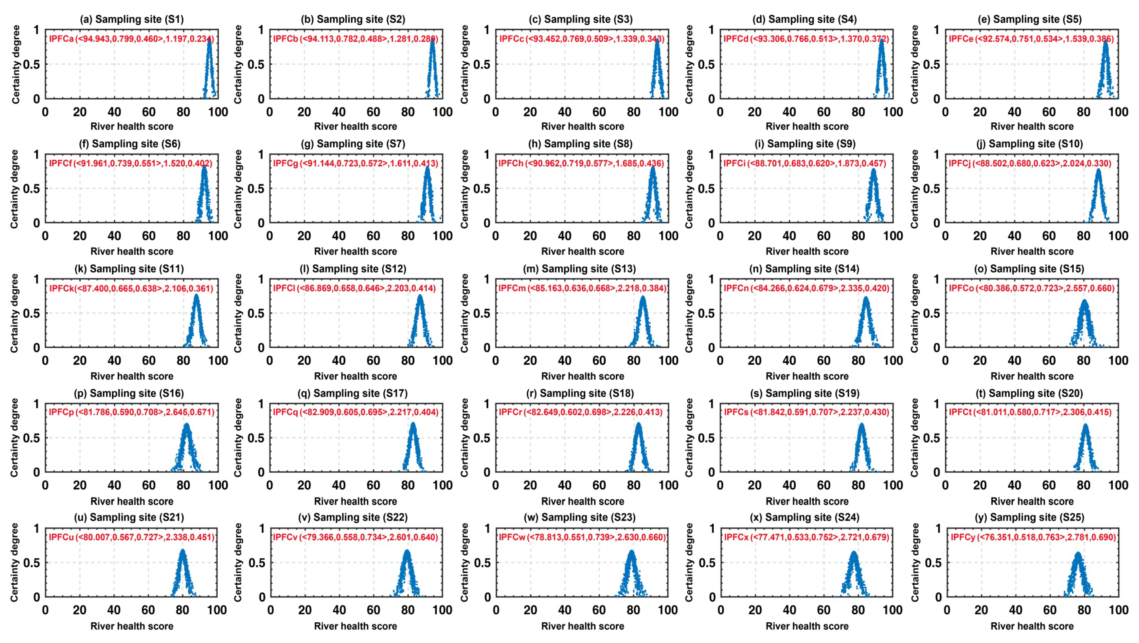
3.3.1. IPFC of Sampling Sites

This study employed 25 sampling sites to assess the health status of the Lhasa River. The locations of sampling sites are depicted in Figure 1, and the cloud diagrams are shown in Figure 8. The health scores of sampling sites exhibited a declining trend from the URLR to the LRLR. Notably, some sampling sites in the LRLR had lower Ex, with lower health scores. Furthermore, sampling sites S24 and S25 exhibited the lowest u and the highest v, suggesting that a higher fuzziness existed in these sites. Compared with the sampling sites in the URLR and MRLR, En and He were larger in the LRLR, indicating that the data from sampling sites in the LRLR possessed greater randomness and lower stability. The aforementioned IPFC diagrams indicated lower health scores and more unstable data in the LRLR, in comparison with the URLR and MRLR. Overall, IPFC showed a leftward shift trend from the URLR to the LRLR, and the peak value gradually decreased, while the dispersion of cloud droplets gradually increased.

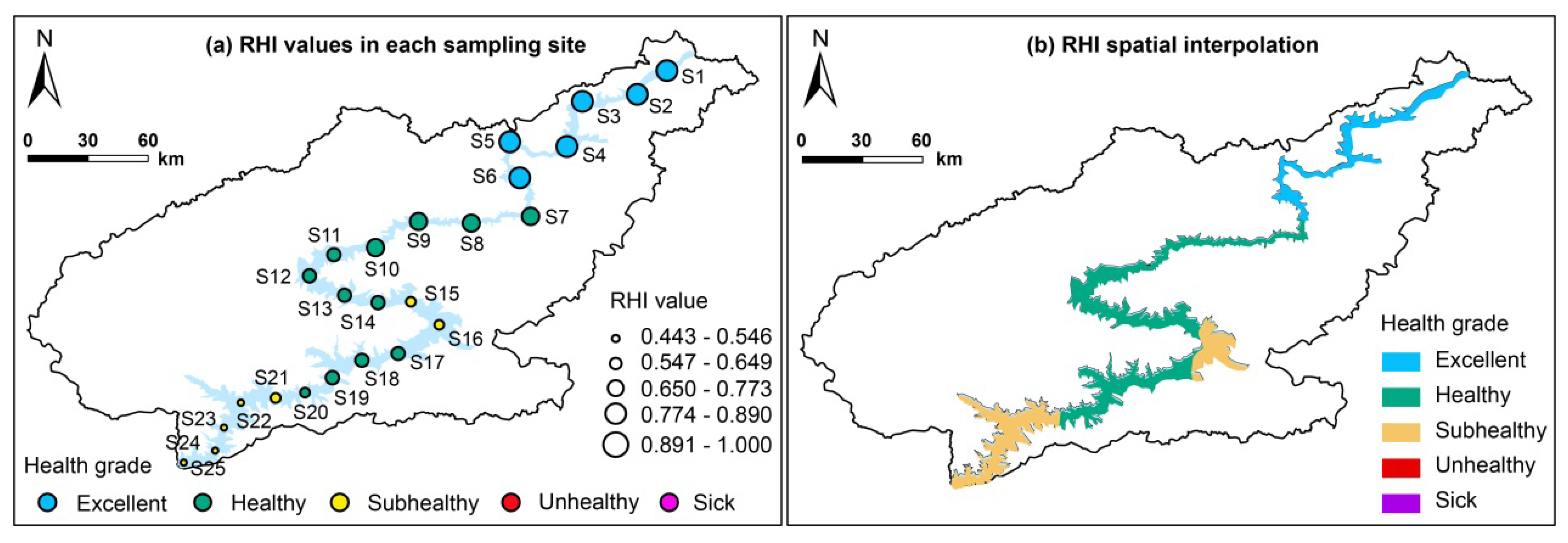
3.3.2. Health Status of Sampling Sites

Six sampling sites (S5, S6, S4, S3, S2, and S1) exhibited an excellent status. Twelve sampling sites (S20, S19, S14, S18, S17, S13, S12, S11, S10, S9, S8, and S7) were classified as healthy. Seven sampling sites (S25, S24, S23, S22, S15, S16, and S21) demonstrated subhealthy conditions. S1 and S25 in the LRLR represented the highest and lowest health levels, respectively. Generally, both the RHI and the health status of the sampling sites displayed a declining trend from the URLR to the LRLR.
The distribution characteristics of RHI values and the health state across the 25 sampling sites are illustrated in Figure 9a, and the spatial interpolation of the health state was shown in Figure 9b. The seven sampling sites in the URLR (S1–S7) were less disturbed by anthropogenic disturbance, with the health states categorized as excellent and healthy.
In the MRLR, sampling sites S8, S9, S10, S11, S12, S13, and S14 maintained a healthy level. However, sampling sites S15, situated at the terminal end of the reservoir, and S16, located downstream of the hydropower station, were affected by the construction of water conservancy projects; both S15 and S16 were at the subhealthy level. Compared with the URLR and MRLR, the health status in the LRLR showed an obvious downward trend. S17, S18, S19, and S20 were classified as healthy, and five sampling sites (S21, S22, S23, S24, and S25) were classified as subhealthy.
Overall, an obvious spatial difference occurred in the health state of sampling sites along the LR. The URLR demonstrated a superior health state, while the health state in the MRLR and LRLR was not ideal. To effectively ameliorate the health state of LR, measures such as ecological compensation, regulating religious release activities, and optimizing urban development can be properly implemented in the future.

3.4. Comparison of Different Parameters and Methods

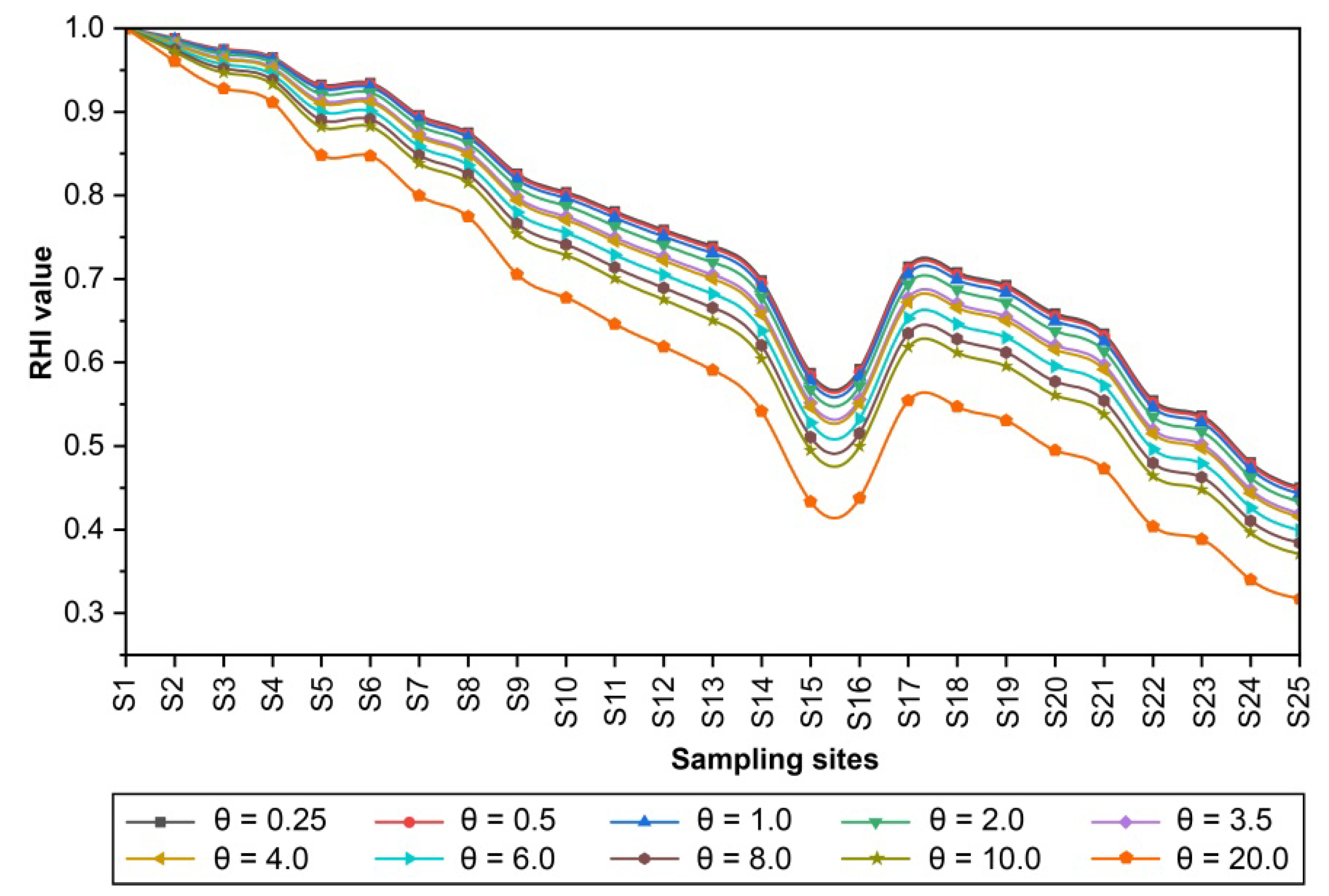
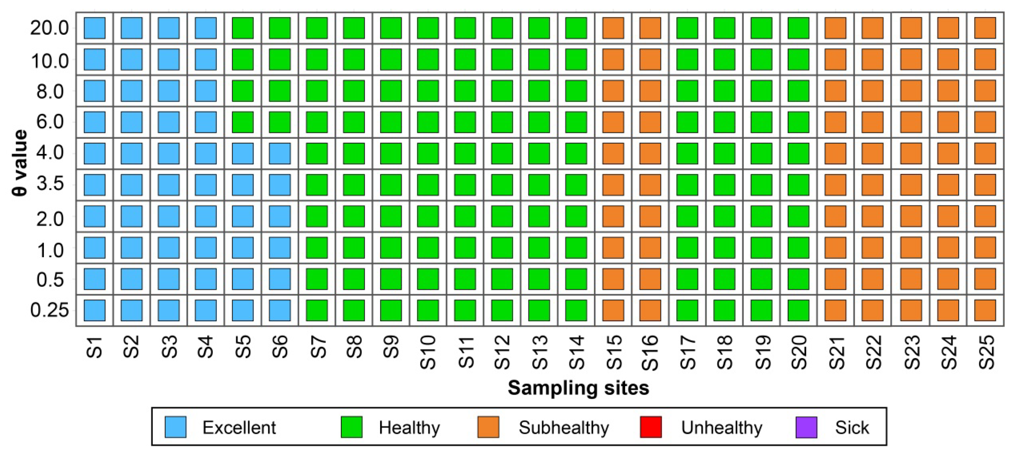
3.4.1. Comparison of Different Parameters

The TODIM model can fully reflect the decision-maker’s bounded rationality by modifying the parameter θ. θ is the loss attenuation coefficient, which represents the decision-maker’s preference towards losses [28]. The parameter θ is constrained by the condition θ > 0. If θ > 1, the decision-maker is less sensitive to loss (risk appetite) [29]. This study conducted simulation experiments using ten distinct θ values (θ = 0.25, 0.5, 1.0, 2.0, 3.5, 4.0, 6.0, 8.0, 10.0, and 20.0). Figure 10 illustrates the RHI values for 25 monitoring sites corresponding to these different θ values.
For different θ values, the health states are shown in Figure 11. With the change in the θ value, the health states of sampling sites can be roughly divided into two phases: (i) Phase I (θ ≤ 4): the RHI exhibited a fluctuating downward trend as θ increased, and the health levels of sampling sites remained constant; (ii) Phase II (θ > 4): the fluctuating downward trend occurred in RHI, with increasing θ. Notably, the health levels changed, whereby S5 and S6 decreased from excellent to the healthy level.

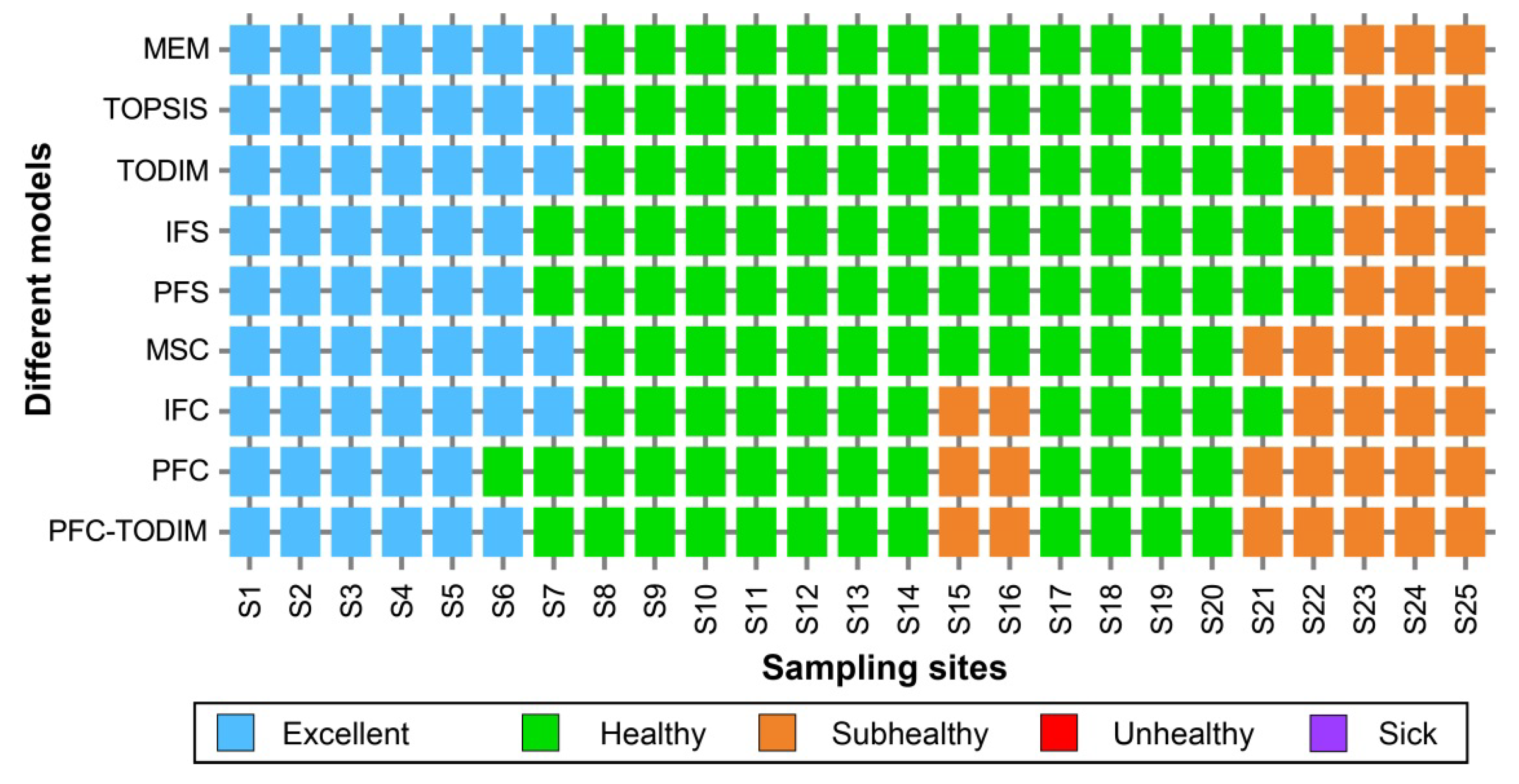
3.4.2. Comparison of Different Methods

A comparative analysis of various methodologies was applied in the Lhasa River area to validate the efficiency of the PFC-TODIM model for REHA. As shown in Figure 12, the matter-element model (MEM) [30], the technique for order of preference by similarity to ideal solution (TOPSIS) [31], TODIM [32], intuitionistic fuzzy sets (IFSs) [33], Pythagorean fuzzy sets (PFSs) [25], multidimensional similarity cloud (MSC) [26], intuitionistic fuzzy cloud (IFC) [9], Pythagorean fuzzy cloud (PFC) [27], and PFC-TODIM models were selected to carry out the study in the Lhasa River, and the results obtained using the above nine methods were compared and analyzed.
The MEM and TOPSIS models yielded the most optimistic results. Among the 25 sampling sites, only S23, S24, and S25 in the LRLR belonged to the subhealthy state, while the other sampling sites were excellent and healthy. The TODIM model elevated S7 from healthy to excellent, as well as some sites from subhealthy to healthy. The IFS and PFS models produced identical results, elevating S15, S16, S21, and S22 from subhealthy to healthy. The MSC model improved the health levels of sampling sites S7, S15, and S16. The PFC model only altered the health status of S6. Therefore, the similarity of results between the PFC-TODIM model and the other models was quantified as follows: 80% similarity with the MEE and TOPSIS models, 84% similarity with the TODIM, IFS, and PFS models, 88% similarity with the MSC model, 92% similarity with the IFC model, and 96% similarity with the PFC model.

4. Discussion

4.1. Driving Factors for River Ecosystem Health

The health status of evaluation indicators in the LR was in the order of URLR > MRLR > LRLR. The main reasons were that the URLR was less disturbed by anthropogenic interferences and was obviously healthier than the MRLR and LRLR. The LRLR was affected by factors such as urban development, religious release activities, and hydropower station construction, causing the health status in the LRLR to be lower than the URLR. The URLR experienced minimal anthropogenic disturbance, with the river water primarily replenished by atmospheric precipitation, snowmelt, and groundwater infiltration. The URLR exhibited abundant runoff, fulfilling ecological requirements [34]. No indicators in the URLR were categorized as subhealthy, unhealthy, and sick. This indicated that the URLR maintained a favorable health status, and all indicators were at a good health level.
The MRLR included nine sampling sites (S8–S16), with three (S13–S15) situated in the reservoir area between the Pangdo and Zhikong hydroelectric stations. Thus, the health statuses in these sites were adversely affected by dam construction [35]. The primary factor was the presence of two dams, which impeded river longitudinal connectivity [36]. Furthermore, changes in river morphology and the environment induced by dam construction adversely affected the aquatic organism distributions and migration patterns [37].
Compared with the URLR and MRLR, the health status in the LRLR showed an obvious downward trend. This deterioration could be attributed to several factors. Primarily, urbanization development escalated the exploitation of water resources, riparian zones, and land resources in the LRLR. Additionally, urban domestic wastewater compromised water quality in the urban river sections to some extent [9]. Furthermore, the profound influence of Tibetan Buddhism on the region has led to the release of fish as a Buddhist teaching. Previous studies indicated that the introduction of non-native fish species resulted in habitat encroachment and posed a threat to the living environment of indigenous fish [38].

4.2. Robustness of the PFC-TODIM Model

The RHI values exhibited a declining trend from the URLR to the LRLR, with notable fluctuations at monitoring sites S15 and S16 (Figure 10). The RHI for the URLR was significantly higher, indicating that a better health status existed in the URLR than the MRLR and LRLR. When the parameter θ assumed values of 0.25, 0.5, 1.0, 2.0, 3.5, and 4.0, the RHI curves demonstrated remarkable proximity and adhered to consistent trends. However, as θ increased to 6.0, 8.0, 10.0, and 20.0, a more pronounced decline in RHI was observed. These characteristics suggested an inverse relationship between θ and RHI values. As θ increased, there was a tendency for RHI values to decrease. Moreover, higher values of θ corresponded to increased sensitivity in RHI fluctuations.
The results demonstrated that irrespective of the θ value, the health levels of 23 sampling sites remained constant (Figure 10 and Figure 11). This stability in 92% of the sampling sites validated the robustness of the PFC-TODIM model. Concurrently, it is noteworthy that as the loss attenuation coefficient θ increased, the health levels of sampling sites S5 and S6 changed. This observation underscored the influence of the decision-maker’s bounded rationality on REHA results, thereby exemplifying the model’s sensitivity.
A critical and challenging aspect of multi-criteria decision-making methods based on prospect theory is the establishment of reference points within the decision-making process. The TODIM model effectively addressed this challenge by incorporating the decision-maker’s psychological behavior without necessitating the determination of decision reference points. This model, predicated the “bounded rationality hypothesis” and provided technical support for decision-makers to more effectively select “satisfactory solutions” when undertaking risk decisions [39]. This study integrated the TODIM model with PFC theory to construct a PFC-TODIM model within a Pythagorean fuzzy environment. Simulation experiments examined how changes in the loss attenuation coefficient θ affected the PFC-TODIM model’s sensitivity and robustness, laying the groundwork for future studies and improvements.
Simulation results demonstrated that the PFC-TODIM model did not need to establish reference points for calculating the absolute prospect value of alternatives. It employed pairwise comparisons to compute relative dominance under different attribute states, thereby simplifying the decision-making process. Furthermore, a decision-maker’s risk aversion significantly impacted outcomes, proving crucial for REHA in the QTP. When evaluating a river with poor health and weak self-repair ability, a smaller θ value (0 < θ ≤ 1) in the PFC-TODIM model can be chosen to reveal the decision-maker’s risk aversion. Given the enhanced capacity for self-repair and external risk resistance, a larger θ value (θ > 1) may be more appropriate when using the PFC-TODIM model, taking into account the decision-maker’s risk appetite psychology. Considering the inherent ecological vulnerability of rivers in the QTP, a smaller θ was recommended during the REHA process. In this study, the θ value was set to one based on previous research experience [12]. The PFC-TODIM model can be extended to other REHA studies in different regions and different background conditions. It enabled the dynamic evaluation of REHA under uncertainty, taking into account the characteristics of the research subject and the decision-maker’s bounded rationality. This approach provided valuable insights for REHA and informed targeted ecological restoration efforts in the QTP.

4.3. Model Advantage

The comparison of different methods is shown in Figure 12. When the decision-making process exceeds the application capability of the model, the model may produce biased results [40]. The MEM integrates the matter-element method with extension set theory to quantitatively address multi-attribute decision problems. The TOPSIS model is a distance-based comprehensive decision algorithm that optimizes ranking based on the proximity of the decision objects to the idealized targets [41]. The TODIM model is a multi-attribute decision-making method based on prospect theory and a decision-maker’s psychological behavior [42]. MEM and the TOPSIS and TODIM models do not incorporate randomness and fuzziness into the REHA process, leading to better results [27]. The IFS and PFS models only consider fuzziness in the evaluation process, neglecting randomness, which results in a health status with greater randomness than reality [21]. Although randomness is considered, the MSC model does not involve fuzziness, which results in a health status with greater fuzziness than reality [10]. The IFC, PFC, and PFC-TODIM models all consider both randomness and fuzziness, yielding similar results. The PFC-TODIM model shows over 90% similarity with both the IFC and PFC models. Notably, sampling sites S15 and S16 were classified as healthy by MEM and the TOPSIS, TODIM, IFS, PFS, and MSC models. They were located at the terminal end of a reservoir in the MRLR, significantly impacted by reservoir construction and dam obstruction. The longitudinal connectivity of LR and the health status of aquatic organisms were not ideal. Classifying these sites as healthy may obscure the true health levels, which impedes the identification of river health status in ecologically vulnerable areas.
Empirical studies showed that there were significant errors in the local monitoring sites due to the instability of the IFC model during REHA [27]. For example, the sampling site S21 was located in the urban section of the LRLR, with high human disturbance and poor health status. The IFC model determined it to be healthy, which was obviously inconsistent with reality. Although the PFC model improved the IFC model and obtained better calculations, it might underestimate the health levels at local monitoring sites. Additionally, the monitoring site S6 was located in the URLR, where higher elevations were almost undisturbed by human activity. River segments in their natural state should be excellent in the monitoring site S6. Collectively, if randomness and fuzziness were incompletely or not considered in the evaluation process, the health levels might be overestimated. If randomness and fuzziness were considered simultaneously, the health levels might be underestimated. The PFC-TODIM method optimized the PFC model by absorbing the bounded rationality of decision-makers. This approach could effectively consider the superimposed effects of the uncertainty input, random environment, and bounded rationality in the REHA process, and the obtained results were more consistent with reality.
Overall, the traditional method for REHA had not effectively integrated uncertainty factors and the bounded rationality into the REHA, resulting in larger errors. To overcome the above defects, this study extended the TODIM model to the PFC environment and developed the PFC-TODIM model based on prospect theory. This model could simultaneously consider the superimposed effects of uncertainty data, the random environment, and the bounded rationality in the REHA, effectively improving the REHA accuracy under an uncertain environment. It also enriched the REHA methodologies and provided a foundation for managing river ecosystems in the QTP.

4.4. Adaptive Management Measures

To enhance the ecological barrier function of the QTP and promote a sustainable cycle within the LR ecosystem, adaptive management countermeasures should be developed following the natural succession laws of the Plateau ecosystem. River protection measures and supporting policies should be adopted progressively to strengthen the river ecosystem’s self-healing capability and stability, as well as the ecological barrier and service functions in the QTP. As an important ecological functional area on the Tibetan Plateau, strengthening the ecological barrier function of the Lhasa River is of great significance for maintaining regional ecological security. This study formulated adaptive management measures based on the peculiarity of river ecosystems in the QTP. The specific measures were drawn as follows:
(1)
Improvement of river connectivity
To ensure aquatic connectivity between the LR and the Yarlung Tsangpo River, connectivity restoration measures were mainly implemented in the MRLR and LRLR. Specific measures include (i) guaranteeing the smooth flow of fish migratory corridors through the joint scheduling of constructed water conservancy projects, (ii) releasing endangered native fish to improve exchange between upstream and downstream fish populations and maintain the aquatic ecosystem health, and (iii) constructing the fishway to mitigate the effects of fish blockage by the cascade hydropower stations in the MRLR and LRLR.
(2)
Fine management of riparian
To ensure riparian stability and safety, the curving and gentle characteristics of natural riverbanks should be maintained to the greatest extent feasible. The riparian should be managed hierarchically, and the riparian functional and control area should be delineated in the LR basin, according to the requirements of China’s River Chief system. Furthermore, ecological and engineering measures could be integrated to restore riparian zone ecosystems. Facility materials and structures suitable for aquatic organism attachment and growth should be designed to improve aquatic habitat conditions and meet habitat diversity requirements.
(3)
Conservation of natural wetlands
To enhance the water conservation capacity in the URLR, comprehensive soil and water conservation strategies were implemented. These strategies encompassed the preservation of natural vegetation and the mitigation of point and non-point source pollution in the MRLR and LRLR, respectively. Two crucial measures were pivotal for preserving the extent and functionality of natural wetlands: enhancing the protection of marshy meadows in the URLR and implementing ecological water replenishment in the MRLR and LRLR. Additionally, a wetland ecological environment monitoring system was instituted, facilitating the implementation of ecological compensation schemes [43,44]. These initiatives collectively aimed to foster increased engagement and enthusiasm among basin residents for wetland protection, thereby promoting a more holistic and sustainable approach to wetland conservation.
(4)
Reduction in water environment pollution
The separate systems for rainwater and sewage were implemented in the urban area of Lhasa to improve the construction of sewage pipe networks and reduce point source pollution from industrial wastewater and urban domestic sewage. In addition, rural non-point source pollution in Lhasa was mainly concentrated in the Dangxiong, Linzhou, and Dulongdeqing counties. The layout of grazing and livestock farming should be adjusted to reduce non-point source pollution from animal husbandry. In summary, accelerating the construction of sewage treatment plants, improving sewage pipe networks and supporting facilities, and encouraging the reuse of industrial wastewater could effectively reduce water pollution in the basin.
Additionally, human factors are equally important, and ecological environmental protection publicity and education should be strengthened to raise the awareness of ecological protection in local communities. At the same time, it is necessary to focus on the inheritance and application of traditional ecological wisdom and integrate the ecological concepts of traditional Tibetan culture into modern ecological protection practices. The ultimate goal is to build an ecosystem in which human beings and nature coexist harmoniously so that the Lhasa River Basin can truly become an important barrier to the ecological security of the Tibetan Plateau.

4.5. Limitations and Future Research

The present study has several limitations that warrant consideration when interpreting and generalizing its findings. This study focused on the LR basin with a sparse population situated in the western QTP. Due to safety concerns and accessibility constraints in remote areas, our investigation was limited to 25 sampling sites for assessing river health status. Future research will aim to optimize the sampling strategy by increasing the frequency and number of sites, as well as refining the indicator system with the current findings. Data collection was confined to the flood and non-flood seasons in 2021. Subsequent studies will implement long sequence dynamic monitoring to reveal the inter-annual variability and driving mechanisms of health status. Moreover, due to limitations in field monitoring data, this study only used the Lhasa River as a typical case. In future research, other plateau rivers will be selected for comparative studies to further verify the reliability and applicability of the developed model.

5. Conclusions

Geographic location and climate affect the vulnerability of river ecosystems in the QTP. Due to the special geographical location in some rivers of the QTP, it is extremely difficult to collect and monitor data. Additionally, fragility in the plateau river ecosystem causes data instability. Accordingly, unavoidable uncertainties existed in the REHA of the QTP. The conventional method did not adequately account for the above uncertainties, resulting in biased results. Using the PFC-TODIM model, this study developed a new framework to conduct REHA with uncertainty. The indicator system with multisource data was established based on the unique ecological features of the QTP. We examined the LR as a typical case for determining its health status, underlying mechanisms, and potential risks. The main conclusions were as follows:
(1)
The URLR were relatively less disturbed by human activities, and the health status of evaluation indicators was better than the MRLR and LRLR. Affected by human activities, obvious spatial differences were noted in the health status of the URLR, MRLR and LRLR. During the study period, the health compliance rates in the URLR, MRLR, and LRLR were 100%, 81.25%, and 62.5%, respectively;
(2)
The RHI and health status of each monitoring site showed a decreasing tendency from the URLR to the LRLR. During the study period, there were no unhealthy and sick sampling sites, and the number of sampling sites in the subhealthy, healthy, and excellent states accounted for 28%, 48%, and 24% of the total, respectively;
(3)
Simulation results demonstrated that the PFC-TODIM model did not need to establish reference points for calculating the absolute prospect value of alternatives. It employed pairwise comparisons to compute relative dominance under different attribute states, thereby reducing the complexity and improving decision-making efficiency;
(4)
The bounded rationality of decision-makers will affect the REHA results. When evaluating a river with poor health and weak self-repair ability, a smaller θ value (0 < θ ≤ 1) can be chosen to reflect the decision-maker’s risk aversion. Given the enhanced capacity for self-repair and external risk resistance, a larger θ value (θ > 1) may be more appropriate, taking into account the decision-maker’s risk appetite psychology;
(5)
The PFC-TODIM model optimizes the PFC model by absorbing the bounded rationality of decision-makers. This model can effectively consider multiple uncertainties (input uncertainty, environmental stochasticity, and a decision-maker’s bounded rationality), thereby improving the REHA accuracy and robustness. It also enriched the REHA methodologies and provided a foundation for managing river ecosystems in the QTP.

Author Contributions

Y.X.: Writing—original draft. Y.L.: Supervision. X.W.: Editing and resources. J.Z.: Editing and resources. Z.Z.: Visualization, methodology, and supervision. All authors have read and agreed to the published version of the manuscript.

Funding

This work was supported by the open foundation of Key Laboratory of Integrated Regulation and Resource Development on Shallow Lake of Ministry of Education (B240203001).

Institutional Review Board Statement

Not applicable.

Informed Consent Statement

Not applicable.

Data Availability Statement

Data is contained within the article.

Conflicts of Interest

The authors declare no conflicts of interest.

References

  1. Karr, J.R. Defining and Measuring River Health. Freshw. Biol. 1999, 41, 221–234. [Google Scholar] [CrossRef]
  2. Norris, R.H.; Thoms, M.C. What Is River Health? Freshw. Biol. 1999, 41, 197–209. [Google Scholar] [CrossRef]
  3. Norris, R.H.; Hawkins, C.P. Monitoring River Health. Hydrobiologia 2000, 435, 5–17. [Google Scholar] [CrossRef]
  4. Fairweather, P.G. State of Environment Indicators of ‘River Health’: Exploring the Metaphor. Freshw. Biol. 1999, 41, 211–220. [Google Scholar] [CrossRef]
  5. Singh, P.K.; Saxena, S. Towards Developing a River Health Index. Ecol. Indic. 2018, 85, 999–1011. [Google Scholar] [CrossRef]
  6. Pinto, U.; Maheshwari, B.L. River Health Assessment in Peri-Urban Landscapes: An Application of Multivariate Analysis to Identify the Key Variables. Water Res. 2011, 45, 3915–3924. [Google Scholar] [CrossRef]
  7. An, K.-G.; Park, S.S.; Shin, J.-Y. An Evaluation of a River Health Using the Index of Biological Integrity along with Relations to Chemical and Habitat Conditions. Environ. Int. 2002, 28, 411–420. [Google Scholar] [CrossRef]
  8. Wang, S.; Zhang, Q.; Yang, T.; Zhang, L.; Li, X.; Chen, J. River Health Assessment: Proposing a Comprehensive Model Based on Physical Habitat, Chemical Condition and Biotic Structure. Ecol. Indic. 2019, 103, 446–460. [Google Scholar] [CrossRef]
  9. Zhang, Z.; Li, Y.; Wang, X.; Zhu, L.; Li, H.; Liu, Y.; Tang, N.; Xu, Y.; Hu, Q. Investigating River Health and Potential Risks Using a Novel Hybrid Decision-Making Framework with Multi-Source Data Fusion in the Qinghai-Tibet Plateau. Environ. Impact Assess. Rev. 2022, 96, 106849. [Google Scholar] [CrossRef]
  10. Zhang, Z.; Li, Y.; Wang, X.; Li, H.; Zheng, F.; Liao, Y.; Tang, N.; Chen, G.; Yang, C. Assessment of River Health Based on a Novel Multidimensional Similarity Cloud Model in the Lhasa River, Qinghai-Tibet Plateau. J. Hydrol. 2021, 603, 127100. [Google Scholar] [CrossRef]
  11. Zhao, Y.W.; Yang, Z.F. Integrative Fuzzy Hierarchical Model for River Health Assessment: A Case Study of Yong River in Ningbo City, China. Commun. Nonlinear Sci. Numer. Simul. 2009, 14, 1729–1736. [Google Scholar] [CrossRef]
  12. Zhang, Z.; Wang, X.; Li, Y.; Liu, Y.; Xu, Y.; Li, J.; Ding, W.; Li, H.; Yang, H. River Ecosystem Health Assessment in the Qinghai-Tibet Plateau: A Novel Hybrid Method Based on Artificial Intelligence and Multi-Source Data Fusion. Expert Syst. Appl. 2024, 251, 124078. [Google Scholar] [CrossRef]
  13. Wang, X.; Liu, X.; Wang, L.; Yang, J.; Wan, X.; Liang, T. A Holistic Assessment of Spatiotemporal Variation, Driving Factors, and Risks Influencing River Water Quality in the Northeastern Qinghai-Tibet Plateau. Sci. Total Environ. 2022, 851, 157942. [Google Scholar] [CrossRef] [PubMed]
  14. Cai, N.; Wang, X.; Wang, W.; Wang, L.; Tian, S.; Zhu, H.; Zhang, X. Accumulation, Ecological Health Risks, and Source Identification of Potentially Toxic Elements in River Sediments of the Qinghai-Tibet Plateau, China. Process Saf. Environ. Prot. 2024, 182, 703–718. [Google Scholar] [CrossRef]
  15. Jiang, W.; Lü, Y.; Liu, Y.; Gao, W. Ecosystem Service Value of the Qinghai-Tibet Plateau Significantly Increased during 25 Years. Ecosyst. Serv. 2020, 44, 101146. [Google Scholar] [CrossRef]
  16. Liu, Y.; Huang, X.; Zhang, Z. Spatiotemporal dynamics and anthropogenic drivers of geological hazard prevention efficiency in China. Cities. 2023, 143, 104607. [Google Scholar] [CrossRef]
  17. Chen, J.; Mei, Y.; Xiao, W. Establishment of the Ecological Relationships and Properties of the Lhasa River Basin Water Resources System, China. Sustain. Cities Soc. 2019, 47, 101477. [Google Scholar] [CrossRef]
  18. Lin, X.; Zhang, Y.; Yao, Z.; Gong, T.; Wang, H.; Chu, D.; Liu, L.; Zhang, F. The Trend on Runoff Variations in the Lhasa River Basin. J. Geogr. Sci. 2008, 18, 95–106. [Google Scholar] [CrossRef]
  19. Su, Y.; Li, W.; Liu, L.; Hu, W.; Li, J.; Sun, X.; Li, Y. Health Assessment of Small-to-Medium Sized Rivers: Comparison between Comprehensive Indicator Method and Biological Monitoring Method. Ecol. Indic. 2021, 126, 107686. [Google Scholar] [CrossRef]
  20. SL/T 793-2020; Technical Guideline for River Health Assessment in China. Ministry of Water Resources of the People’s Republic of China: Beijing, China, 2020.
  21. Zhang, Z.; Liu, Y.; Li, Y.; Wang, X.; Li, H.; Yang, H.; Ding, W.; Liao, Y.; Tang, N.; He, F. Lake Ecosystem Health Assessment Using a Novel Hybrid Decision-Making Framework in the Nam Co, Qinghai-Tibet Plateau. Sci. Total Environ. 2022, 808, 152087. [Google Scholar] [CrossRef]
  22. Yi, Y.; Lin, C.; Wang, W.; Song, J. Habitat and Seasonal Variations in Bacterial Community Structure and Diversity in Sediments of a Shallow Lake. Ecol. Indic. 2021, 120, 106959. [Google Scholar] [CrossRef]
  23. Lin, Z.; Xu, Y.; Wang, Q.; Luo, S.; Lu, M.; Yu, Z. River System Changes under Urban Expansion: Insights from the Suzhou-Wuxi-Changzhou Metropolitan Area, China. J. Hydrol. Reg. Stud. 2024, 53, 101766. [Google Scholar] [CrossRef]
  24. Liu, Y.; Zhang, Z.; Huang, X. A Novel Coupling Cloud Decision-Making Framework for Investigating Population-Economy-Water Consumption Nexus in the Inner Mongolia Reaches of the Yellow River, China. Environ. Impact Assess. Rev. 2023, 98, 106923. [Google Scholar] [CrossRef]
  25. Yager, R.R. Pythagorean Membership Grades in Multicriteria Decision Making. IEEE Trans. Fuzzy Syst. 2014, 22, 958–965. [Google Scholar] [CrossRef]
  26. Yao, J.; Wang, G.; Wang, L.; Zhang, X.; Wang, P. Assessing the Spatiotemporal Variability of Lake Water Quality Using a Novel Multidimensional Shape—Position Similarity Cloud Model. J. Hydrol. 2021, 599, 126379. [Google Scholar] [CrossRef]
  27. Zhang, Z.; Li, Y.; Wang, X.; Liu, Y.; Tang, W.; Ding, W.; Han, Q.; Shang, G.; Wang, Z.; Chen, K.; et al. Investigating River Health across Mountain to Urban Transitions Using Pythagorean Fuzzy Cloud Technique under Uncertain Environment. J. Hydrol. 2023, 620, 129426. [Google Scholar] [CrossRef]
  28. Ren, P.; Xu, Z.; Gou, X. Pythagorean Fuzzy TODIM Approach to Multi-Criteria Decision Making. Appl. Soft Comput. 2016, 42, 246–259. [Google Scholar] [CrossRef]
  29. Llamazares, B. An Analysis of the Generalized TODIM Method. Eur. J. Oper. Res. 2018, 269, 1041–1049. [Google Scholar] [CrossRef]
  30. Deng, X.; Xu, Y.; Han, L.; Yu, Z.; Yang, M.; Pan, G. Assessment of River Health Based on an Improved Entropy-Based Fuzzy Matter-Element Model in the Taihu Plain, China. Ecol. Indic. 2015, 57, 85–95. [Google Scholar] [CrossRef]
  31. Xu, W.; Dong, Z.; Ren, L.; Ren, J.; Guan, X.; Zhong, D. Using an Improved Interval Technique for Order Preference by Similarity to Ideal Solution to Assess River Ecosystem Health. J. Hydroinformatics 2019, 21, 624–637. [Google Scholar] [CrossRef]
  32. Ashofteh, P.-S.; Golfam, P.; Loáiciga, H.A. Evaluation of River Water Transfer Alternatives with the TODIM Multi-Criteria Decision Making Method. Water Resour. Manag. 2020, 34, 4847–4863. [Google Scholar] [CrossRef]
  33. Atanassov, K.T. Intuitionistic Fuzzy Sets. In Intuitionistic Fuzzy Sets: Theory and Applications; Atanassov, K.T., Ed.; Studies in Fuzziness and Soft Computing; Physica-Verlag HD: Heidelberg, Germany, 1999; pp. 1–137. ISBN 978-3-7908-1870-3. [Google Scholar]
  34. Mao, G.; Zhao, Y.; Zhang, F.; Liu, J.; Huang, X. Spatiotemporal Variability of Heavy Metals and Identification of Potential Source Tracers in the Surface Water of the Lhasa River Basin. Environ. Sci. Pollut. Res. 2019, 26, 7442–7452. [Google Scholar] [CrossRef]
  35. Tian, P.; Lu, H.; Feng, W.; Guan, Y.; Xue, Y. Large Decrease in Streamflow and Sediment Load of Qinghai–Tibetan Plateau Driven by Future Climate Change: A Case Study in Lhasa River Basin. Catena 2020, 187, 104340. [Google Scholar] [CrossRef]
  36. Liu, Y.; Su, W.; Zhu, Y.; Xiao, L.; Hu, T. Endocrine Disrupting Compounds in the Middle and Lower Reaches of the Lhasa River Basin: Occurrence, Distribution, and Risk Assessment. Sci. Total Environ. 2020, 727, 138694. [Google Scholar] [CrossRef]
  37. You, Y.; Li, Z.; Gao, P.; Hu, T. Impacts of Dams and Land-Use Changes on Hydromorphology of Braided Channels in the Lhasa River of the Qinghai-Tibet Plateau, China. Int. J. Sediment Res. 2022, 37, 214–228. [Google Scholar] [CrossRef]
  38. Du, B.; Ge, J.; Yang, R.; Han, X.; Chen, H.; Li, J.; Zeng, L. Altitude-Dependent Accumulation of Short Chain Chlorinated Paraffins in Fish from Alpine Lakes and Lhasa River on the Tibetan Plateau. Environ. Pollut. 2019, 250, 594–600. [Google Scholar] [CrossRef]
  39. Alali, F.; Tolga, A.C. Portfolio Allocation with the TODIM Method. Expert Syst. Appl. 2019, 124, 341–348. [Google Scholar] [CrossRef]
  40. Kumar, R.; Edalatpanah, S.A.; Jha, S.; Singh, R. A Pythagorean Fuzzy Approach to the Transportation Problem. Complex Intell. Syst. 2019, 5, 255–263. [Google Scholar] [CrossRef]
  41. Yang, T.; Zhang, Q.; Wan, X.; Li, X.; Wang, Y.; Wang, W. Comprehensive Ecological Risk Assessment for Semi-Arid Basin Based on Conceptual Model of Risk Response and Improved TOPSIS Model-a Case Study of Wei River Basin, China. Sci. Total Environ. 2020, 719, 137502. [Google Scholar] [CrossRef]
  42. Krohling, R.A.; Pacheco, A.G.C.; Siviero, A.L.T. IF-TODIM: An Intuitionistic Fuzzy TODIM to Multi-Criteria Decision Making. Knowl.-Based Syst. 2013, 53, 142–146. [Google Scholar] [CrossRef]
  43. Prata, J.C.; Padrão, J.; Khan, M.T.; Walker, T.R. Do’s and Don’ts of Microplastic Research: A Comprehensive Guide. Water Emerg. Contam. Nanoplastics 2024, 3, 8. [Google Scholar] [CrossRef]
  44. Ihsanullah, I.; Khan, M.T.; Hossain, M.F.; Bilal, M.; Ali Shah, I. Eco-Friendly Solutions to Emerging Contaminants: Unveiling the Potential of Bioremediation in Tackling Microplastic Pollution in Water. Adv. Sustain. Syst. 2024, 8, 2400172. [Google Scholar] [CrossRef]
Figure 1. The location of sampling sites and land use in the Lhasa River basin.
Sustainability 17 02041 g001
Figure 2. River ecosystem health assessment of the Lhasa River considering multiple uncertainties.
Sustainability 17 02041 g002
Figure 3. The weights of the 16 evaluation indicators in the Lhasa River.
Sustainability 17 02041 g003
Figure 4. Cloud diagrams of indicators in the Lhasa River.
Sustainability 17 02041 g004
Figure 5. The health statuses of the evaluation indicators in the Lhasa River. The polarized radar maps denote the river health index (RHI).
Sustainability 17 02041 g005
Figure 6. Cloud diagrams of (ad) the criteria levels and (e) target level.
Sustainability 17 02041 g006
Figure 7. Health statuses of (ac) criteria levels and (d) the target level in the Lhasa River. The river health index (RHI) is marked in this figure.
Sustainability 17 02041 g007
Figure 8. Cloud diagrams of 25 sampling sites in the Lhasa River.
Sustainability 17 02041 g008
Figure 9. Health conditions of 25 sampling sites in the Lhasa River.
Sustainability 17 02041 g009
Figure 10. The river health index (RHI) of 25 sampling sites corresponding to different θ values.
Sustainability 17 02041 g010
Figure 11. The health statuses of 25 sampling sites corresponding to different θ values.
Sustainability 17 02041 g011
Figure 12. Comparative analysis of different methods on the health status at 25 sampling sites in the Lassa River.
Sustainability 17 02041 g012
Disclaimer/Publisher’s Note: The statements, opinions and data contained in all publications are solely those of the individual author(s) and contributor(s) and not of MDPI and/or the editor(s). MDPI and/or the editor(s) disclaim responsibility for any injury to people or property resulting from any ideas, methods, instructions or products referred to in the content.

