Abstract
Marine spatial planning (MSP) has emerged as a fundamental process for achieving the balanced development of marine ecology, economy, and society. However, increasing conflicts among multiple marine uses, particularly between port development, industrial activities, fisheries, recreation, and ecological protection, highlight the pressing demand for robust and science-based planning tools. In this study, we propose an integrated analytical framework for multi-objective spatial suitability evaluation to optimize MSP. Using the coastal waters of Dalian, China, as a case study, we evaluated the spatial suitability of five key marine activities (ecological protection, mariculture, port construction, wind energy farm development, and coastal tourism) and applied a multi-criteria decision-making approach to inform spatial zoning. The results emphasize the region’s ecological significance as providing critical habitats and migratory corridors for protected and threatened species as well as fishery resources, while also revealing substantial spatial overlaps between conservation priorities and human activities, particularly in nearshore zones. The optimized zoning scheme classifies 22.0% of the coastal waters as Ecological Redline Zones, 32.4% as Ecological Control Zones, and 45.6% as Marine Exploitation Zones. This science-based spatial classification effectively reconciles ecological priorities with development needs, providing a spatially explicit and policy-relevant decision support tool for MSP.
1. Introduction
Ocean health is intrinsically linked to human well-being [1], and sustaining a healthy ocean is of great importance for the long-term viability of the blue economy [2,3]. However, rapid socio-economic development has intensified conflicts among various marine uses, with the demand for services and resources from sea and coastal areas frequently exceeding their capacities [4]. Moreover, the growth of marine activities has aggravated the degradation of natural habitats, loss of biodiversity and accumulation of contaminants, which, in turn, compromise the sustainable use of marine resources [5].
In this context, marine spatial planning (MSP) has emerged as an essential tool to address these challenges [6]. By analyzing and allocating the spatial and temporal distribution of human activities in marine areas, MSP can provide the balanced development of marine ecology, economy, and society [4]. Nevertheless, the increasing conflicts among diverse marine uses, together with the ongoing ecological degradation, underscore the urgent need for scientifically robust decision-support tools for managers. Hence, marine spatial suitability evaluation can play a pivotal role by integrating environmental, biophysical, and socio-economic factors to identify the most appropriate areas for specific activities, such as mariculture [7,8], wind energy farms [9], or urban development [10], among others. This evaluation process, typically carried out in the early stage of MSP, enables the identification of potential areas for future development and protection within a given sea area, while concurrently accounting for environmental sensitivity and resource availability, thereby contributing to the optimization of MSP schemes [11,12]. This step is also recognized as a key component of MSP by the European Union’s Maritime Spatial Planning Directive (Directive 2014/89/EU) [13] and by organizations such as IOC-UNESCO [14].
Despite its promising initial results, marine spatial suitability evaluation remains challenging. Previous studies have predominantly focused on single objectives, which have enhanced our understanding of the spatial distribution of specific marine activities, yet these efforts have contributed little to comprehensive spatial planning. Although recent research has increasingly sought to integrate disparate spatial suitability evaluations into unified planning frameworks [10,15,16], a consolidated framework specifically addressing marine spatial functional zoning remains absent. Given the diverse demands of stakeholders, ranging from development needs and ecological protection to prevailing socio-economic conditions, future research is essential on implementing multicriteria decision-making in MSP.
In this study, we propose an integrated analytical framework for multi-objective spatial suitability evaluation to optimize MSP schemes. The spatial suitability of key marine activities in the coastal waters of Dalian (China) was evaluated using a comprehensive indicator system, and the optimized MSP scheme was derived. Our approach incorporates the latest spatial management strategies in China and addresses multiple real-world demands by balancing ecological, economic, and social factors, thereby providing insights for the resolution of multi-use conflicts and the implementation of science-based MSP.
2. Study Area
This study was carried out in the coastal waters of Dalian, Liaoning Province, China, located between 38°43′ N and 40°10′ N and 120°58′ E to 123°31′ E in the Bohai Sea and the Yellow Sea, covering an area of approximately 29,000 km2 (Figure 1). Dalian’s extensive coastline, exceeding 2200 km, and its more than 500 islands of varying sizes underscore the region’s rich marine resource endowment [17].
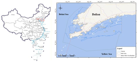
Figure 1.
Location of study area, in the coastal waters of Dalian, Liaoning Province, China, spanning the Bohai Sea and the Yellow Sea.
Dalian is one of the principal port cities in China, serving as a critical coastal hub whose marine economy substantially contributes to regional socio-economic development. Main marine activities include mariculture, fishing, shipping, port construction, and coastal tourism. Ecologically, the region is characterized by a mosaic of diverse ecosystems including coastal saltmarshes, seagrass meadows, and rocky, sandy, and muddy shorelines [18]. These ecosystems support a wide range of biodiversity and habitats but also function as vital migration corridors for birds along the Northeast Asian Flyway [19]. Moreover, the offshore waters provide essential spawning and feeding habitats for various fish species and serve as critical area for the nationally protected spotted seal (Phoca largha) [20,21].
However, the rapid industrialization and urbanization in Dalian have increasingly threatened the marine environment [22]. Issues such as marine pollution, wetland reduction, biodiversity loss, and coastal erosion have intensified [23,24]. Consequently, the intensification of conflicts among competing marine uses poses significant challenges to effective MSP and management (current distribution map of marine use see Figure 2). These challenges necessitate the development and implementation of robust, integrative planning strategies to ensure the sustainable utilization and conservation of marine resources.
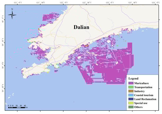
Figure 2.
Current distribution map of marine use in the coastal waters of Dalian, China.
3. Materials and Methods
3.1. Technical Framework
In this study, we propose an analytical framework to optimize MSP via multi-objective spatial suitability evaluation (Figure 3). The framework is structured around three principal components. First, we analyzed factors related to marine ecological protection and exploitation activities and identified relevant evaluation indicators to develop a hierarchical indicator system. Second, we conducted individual marine spatial suitability evaluations for each activity by collecting and processing indicator data, establishing suitability criteria and classification thresholds, and integrating the results to obtain comprehensive evaluations. Finally, we applied the multi-criteria decision analysis approach to synthesize the results and inform the optimization of the overall MSP process.
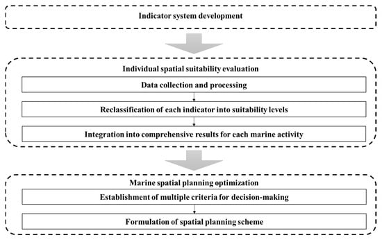
Figure 3.
Technical framework for multi-objective spatial suitability evaluation and spatial planning optimization. (The arrows indicate the data flow among components).
3.2. Indicator System Development
3.2.1. Marine Spatial Planning in China
China has been a global pioneer in MSP. Its efforts date back to the late 1970s [25,26]. The initial framework, Marine Functional Zoning (MFZ), served as the foundation of China’s MSP until 2020. Under MFZ, marine regions were classified into 8 primary and 22 secondary categories (Table 1) based on natural resource presence, geographical characteristics, and socio-economic attributes [27,28,29]. Although MFZ provided a robust basis for marine resource management, it had some limitations, especially the insufficient consideration of ecological protection and its narrow scope, which prevented the integration of land–sea management.

Table 1.
Marine Functional Zoning and Territorial Spatial Planning system in China.
A major policy shift occurred in 2019, when the Chinese government approved the “multi-planning integration” strategy, with the Several Opinions on Establishing Territorial Spatial Planning System and Supervising Implementation [30,31]. This policy established a unified Territorial Spatial Planning System by merging previously separate planning frameworks (e.g., land-use planning, urban planning, and MFZ) into a single overarching framework. Within this new system, marine areas were reclassified into three distinct categories: Marine Ecological Redline Zone, Marine Ecological Control Zone, and Marine Exploitation Zone [32] (Table 1). The Marine Ecological Redline Zone designates areas under strict protection, while the Marine Ecological Control Zone aims to maintain ecosystem services and promote the development of ecological products [33]. This reclassification marks a significant shift from the previous MFZ framework by prioritizing ecological protection and securing adequate spatial allocation for ecological functions. In contrast, the Marine Exploitation Zone accommodates more intensive development activities, such as fisheries, port construction, shipping, and tourism. Notably, the updated framework also eliminates certain terrestrial-overlapping zones (e.g., Agricultural Reclamation Zone and Urban Development Zone), thereby improving land–sea spatial coordination.
In this study, we adopted the new Territorial Spatial Planning framework to optimize marine areas. Specifically, we considered four out of the six categories of Marine Exploitation Zone: Fishery Zone, Industrial, Mineral, and Communication Zone, Transportation Zone, and Entertainment Zone. The remaining two categories (Special Use Zone and Reserved Zone) were excluded, as they include sensitive military areas, scientific research facilities, marine ecological restoration projects, and submarine cultural relics with limited data availability. Moreover, the location of these areas is largely selected by policy and management decisions, making it difficult to conduct suitability evaluations. To streamline the research, we selected one representative activity for each category. Mariculture was chosen for the Fishery Zone, wind energy farm development for the Industrial, Mineral, and Communication Zone, port construction for the Transportation Zone, and coastal tourism for the Entertainment Zone. The selection of these specific activities was guided by several key considerations. First, they possess significant economic and ecological impacts, making them critical for understanding the dynamics of marine utilization. Second, comprehensive and reliable data were available, ensuring robust and sound analysis. Third, these activities align well with local development strategies in Dalian, thus enhancing the scientific validity of the study.
3.2.2. Indicator System
The indicators employed for the marine spatial suitability evaluation are summarized in Table 2.
The ecological protection evaluation is organized around three critical ecosystem services: biodiversity maintenance, coastal protection, and carbon sequestration. Criteria for biodiversity maintenance were derived from internationally recognized frameworks, including Key Biodiversity Areas (KBAs) and Ecologically or Biologically Significant Marine Areas (EBSAs) [34,35]. Indicators for coastal protection and carbon sequestration were adapted to Dalian’s coastal ecosystems from previous studies [36,37].
Marine exploitation suitability was evaluated using supporting resources, environmental constraints, and socio-economic constraints. Specifically, mariculture suitability was evaluated focusing on the bottom-sowing method, which constitutes approximately 75% of Dalian’s annual production, and used phytoplankton abundance and substrate type as supporting resource indicators, water quality and disaster risks as environmental constraint indicators [38,39,40]. Port construction suitability was evaluated based on four primary factors of shorelines: substrate type, slope, water depth, and storm surge risk [41,42,43]. Wind energy farm development suitability was evaluated using wind energy density measured at 100 m elevation, with water depth and sea ice risk as the main environmental constraints [44,45,46,47]. According to China’s Offshore Wind Energy Development and Construction Regulations, offshore wind installations must be located at least 10 km offshore [48]. Finally, coastal tourism suitability was determined based on the availability of shoreline resources and high-value tourist attractions, with additional consideration of environmental factors including water quality and red tide risk [41,49].
3.2.3. Individual Marine Spatial Suitability Evaluation
The developed indicator system was operationalized through the compilation of a comprehensive spatial dataset that integrates information from multiple sources, including national monitoring and survey programs (e.g., National Coastal Ecosystem Survey, National Land Survey, National Marine Disaster Risk Census, National Ecological Warning and Monitoring Project), open-access marine data platforms (e.g., National Marine Big Data Service), and peer-reviewed reports (Bulletin of China Marine Disasters) and literature.
Table 2.
Data sources for marine spatial suitability evaluation.
Table 2.
Data sources for marine spatial suitability evaluation.
| Goal | Criteria | Indicator for Dalian Waters | Data Source | Suitability Evaluation | ||
|---|---|---|---|---|---|---|
| Suitable | Moderately Suitable | Unsuitable | ||||
| Marine ecological protection | Habitats of key protected or threatened species | — | [19,21,50] | Habitats of rare and endangered seabirds | — | Other sea areas |
| Habitats with high biodiversity or productivity | Seagrass meadows, tidal flats, estuaries, uninhabited sea islands | National Coastal Ecosystem Survey (2021), Second National Wetland Survey (2014), National Uninhabited Sea Island Survey (2016) | Seagrass meadows; tidal flats with the bird population exceeding 1% of East Asian population, or with a cumulative percentage of area over 50%; estuaries with chlorophyll concentration > 6 μg L−1; uninhabited sea islands with vegetation coverage > 50% | Other tidal flats, estuaries, and unutilized uninhabited sea islands | Other sea areas | |
| Critical habitats supporting key life-history stages of species | Fishery spawning, feeding, wintering grounds, and migration areas, aquatic germplasm resource protected areas | Ministry of Agriculture, 2002; Notification of the Ministry of Agriculture and Rural Affairs (https://www.moa.gov.cn (accessed on 2 January 2025)) | Fishery spawning grounds, aquatic germplasm resources protection areas | Fishery wintering, feeding and migration areas | Other sea areas | |
| Habitats offering coastal protection service | Rocky, sandy, muddy shorelines | National Coastal Ecosystem Survey (2021), National Sea Area Dynamic Monitoring System | Natural shorelines > 500 m and no utilization by the seaward side | Natural shorelines > 500 m | Other sea areas | |
| Habitats offering carbon sequestration service | Coastal saltmarshes, seagrass meadows | National Coastal Ecosystem Survey (2021) | Coastal saltmarshes (invasive species communities excluded), seagrass meadows | — | Other sea areas | |
| Mariculture | Supporting resources | Phytoplankton abundance | National Ecological Warning and Monitoring project (2006–2023) | ≥1.0 × 10⁷ cells m−3 | <1.0 × 10⁷ cells m−3 | — |
| Substrate type | Global ocean sediment product (https://oceancloud.nmdis.org.cn (accessed on 2 January 2025)) [51] | Sand or silt | — | Gravel | ||
| Environmental constraints | Seawater quality | National Ecological Warning and Monitoring project (2006–2023) | First- or second-class seawater quality | — | Other classes | |
| Red tide risk | Bulletin of China Marine Disasters (https://www.mnr.gov.cn/sj/sjfw/hy/gbgg/zghyzhgb/index_1.html (accessed on 2 January 2025)) | Numbers of red tide records < 3 | Numbers of red tide records ≥ 3 | — | ||
| Sea ice risk | Numbers of sea ice records < 6 | Numbers of sea ice records ≥ 6 | — | |||
| Port construction | Supporting resources | Slope (average slope within 2 km buffer zone) | 90 m resolution Digital Elevation Model (DEM) data of Chinese coastal areas (2020) | ≤8° | 8–15° | >15° |
| Shoreline substrate type | Third National Land Survey (2020) | Artificial shoreline, rocky shoreline | Muddy shoreline | Sandy, biogenic shoreline | ||
| Water depth (Distance to 10 m depth contour) | Global bathymetry grid product (https://oceancloud.nmdis.org.cn/ (accessed on 2 January 2025)) | <10 km | 10–15 km | ≥15 km | ||
| Environmental constraint | Storm surge risk | National Marine Disaster Risk Census | Other classes | Fourth class | — | |
| Wind energy farm development | Supporting resources | Wind energy density | China Meteorological Administration | ≥500 W m−2 | 350–500 W m−2 | <350 W m−2 |
| Environmental constraints | Water depth | global bathymetry grid product (https://oceancloud.nmdis.org.cn/ (accessed on 2 January 2025)) | ≤50 m | >50 m | — | |
| Sea ice risk | Bulletin of China Marine Disasters (https://www.mnr.gov.cn/sj/sjfw/hy/gbgg/zghyzhgb/index_1.html (accessed on 2 January 2025)) | Numbers of sea ice records < 6 | Numbers of sea ice records ≥ 6 | — | ||
| Socio-economic constraint | Distance to shoreline | Third National Land Survey (2020) | ≤10 km | — | >10 km | |
| Coastal tourism | Supporting resources | Tourism resource | Third National Land Survey (2020), Points of Interest (POI) on Baidu Map (https://map.baidu.com (accessed on 2 January 2025)) | Biogenic/sandy/rocky shoreline; AAAAA, AAAA, and AAA National Tourist Attractions; National Marine Park | Muddy shoreline; other tourist attractions; other parks | Artificial shoreline |
| Environmental constraint | Seawater quality | National Ecological Warning and Monitoring (2006–2023) | First- or second-class seawater quality | — | Other classes | |
| Red tide risk | Bulletin of China Marine Disasters (https://www.mnr.gov.cn/sj/sjfw/hy/gbgg/zghyzhgb/index_1.html (accessed on 2 January 2025)) | Numbers of red tide records < 3 | Numbers of red tide records ≥ 3 | — | ||
Each evaluation indicator was then classified into three levels (suitable, moderately suitable, and unsuitable) and standardized to a common scale (2, 1, and 0, respectively). This classification was based on four key criteria:
- (i).
- Policy compliance, related to China’s ecological protection targets, following the methodologies proposed by Zeng et al. [32];
- (ii).
- Regulatory standards, based on national technical specifications such as China’s Water Quality Standard for Fisheries (GB 11607-89) [52], the Methodology of Wind Energy Resource Assessment for Wind Farm (GB/T 18710-2002) [53], and the Technical Directives for Risk Assessment and Zoning of Marine Disaster Part I: Storm Surge (HY/T 0273-2019) [54];
- (iii).
- Technical requirements, which account for physical constraints specific to certain activities, e.g., sandy or silty substrates for bottom-sowing aquaculture, artificial or rocky shorelines for port construction, and water depth less than 50 m for wind energy farms [45,47];
- (iv).
- Local adaptation, which employs the Jenks Natural Breaks classification to capture region-specific variations in phytoplankton abundance, disaster risk indicators, and tourism resource metrics [55,56].
Finally, the individual indicator scores were synthesized using the extremum method. The maximum method was employed with equal weights for all the ecological protection indicators to delineate the broadest possible ecological zone. The minimum method was used for evaluating the exploitation activities, to ensure that high-risk environmental constraints are prioritized.
3.3. Marine Spatial Planning Optimization
Building on the spatial suitability evaluations for the five key marine activities, we employed a multicriteria decision analysis approach to integrate these suitability outcomes with existing spatial utilization patterns. The primary objective was to optimize the MSP scheme by balancing ecological protection and sustainable exploitation.
The process began with creating a comprehensive spatial data layer that merged the suitability results for all functions into a vector-based mosaic. Each spatial unit’s suitability score then informed functional allocation through a hierarchical decision-making protocol:
- Ecological priority. Spatial units scoring the maximum for ecological protection (score = 2) were designated as Ecological Redline Zones. Low-intensity development areas with limited ecological impact were also included, while high-intensity zones adversely affecting ecological functions were excluded.
- Stable development. Areas currently supporting large-scale exploitation activities with a suitability score ≥1 retained their existing designations to preserve planning continuity and minimize socio-economic disturbances.
- Protection-development coordination. For remaining spatial units, final designations were determined by considering: (i) protection priority for undeveloped areas; (ii) optimization based on the highest suitability score; and (iii) consideration of adjacent exploitation functions using the visual interpretation method to ensure spatial coherence. Notably, for port construction, which is evaluated along the shoreline, a 5 km seaward buffer from the suitable coastline was used as the Port Zone boundary, reflecting the typical spatial extent of port activities in Dalian’s coastal waters.
4. Results
4.1. Individual Suitability Evaluation Results
The spatial suitability of the five distinct marine functions described above was evaluated, and the results for all individual indicators and comprehensive suitability are presented in Figure 4 and Figure 5 and Table 3. The results showed significant differences among the five marine functions. Mariculture exhibited extensive spatial applicability, with suitable and moderately suitable areas accounting for as much as 97.3% of the coastal waters of Dalian, China. In contrast, coastal tourism displayed marked spatial constraints and limited resources, with suitable and moderately suitable areas covering only 1.9% of the study area.
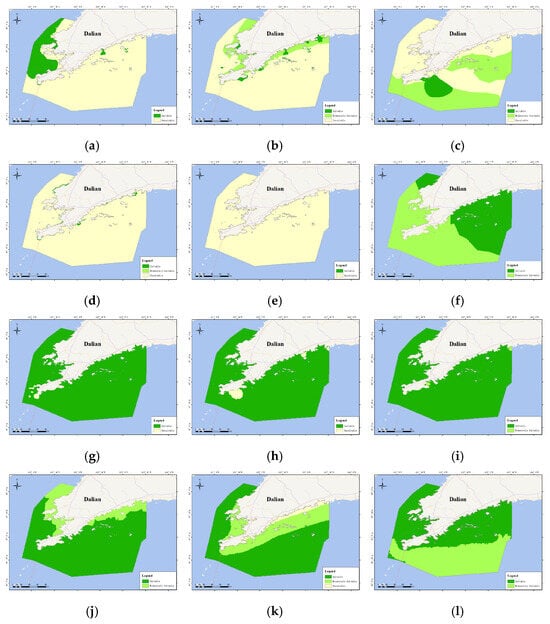
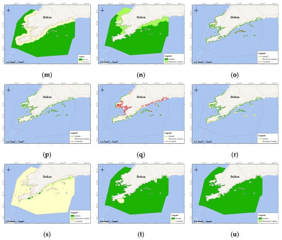
Figure 4.
Spatial distribution of suitability evaluation results for individual criteria of marine ecological protection ((a): habitats of key protected or threatened species, (b): habitats with high biodiversity or productivity, (c): critical habitats supporting key life-history stages of species, (d): habitats offering coastal protection service, (e): habitats offering carbon sequestration service), and for individual indicators of mariculture ((f): phytoplankton abundance, (g): substrate type, (h): seawater quality, (i): red tide risk, (j): sea ice risk), wind energy farm development ((k): wind energy density, (l): water depth, (m): distance to shoreline, (n): sea ice risk), port construction ((o): shoreline substrate type, (p): slope, (q): water depth, (r): storm surge risk), coastal tourism ((s): tourism resources, (t): seawater quality, (u): red tide risk) in the coastal waters of Dalian, China.
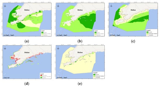
Figure 5.
Spatial distribution of suitability evaluation results for individual activities in the coastal waters of Dalian: (a) marine ecological protection, (b) mariculture, (c) wind energy farm development, (d) port construction, and (e) coastal tourism.
Table 3.
Spatial suitability results in the coastal waters of Dalian, China.
4.2. Marine Spatial Planning Scheme Optimization Result
Figure 6a provides a comprehensive overview of the spatial suitability evaluation results for five distinct activities in the coastal waters of Dalian. In this analysis, the suitability index represents the cumulative sum of the individual suitability scores, with higher values indicating the suitability of an area for a higher number of activities. These areas support both exploitation activities and ecological protection, highlighting the intricate connections and dependencies between development and protection priorities.

Figure 6.
Map of marine spatial suitability index (a) and marine spatial planning optimization scheme (b) in the coastal waters of Dalian, China.
Furthermore, a multicriteria decision analysis approach was employed incorporating the status of regional development and utilization, to delineate an MSP scheme for Dalian’s coastal waters (Figure 6b and Table 4). According to the proposed scheme, Ecological Redline Zones and Ecological Control Zones comprise 22.0% and 32.4% of the marine area, respectively. Both offshore and coastal regions are included within these zones. Offshore areas are predominantly reserved for ecologically dominant functions, such as habitats of key protected species and fisheries resources, while coastal areas have been reconfigured to minimize high-intensity development conflicts and preserve critical estuaries, wetlands, and island-adjacent waters. As a result, some coastal zones have been reclassified to accommodate specific development purposes, including port and fisheries use. Notably, within the Marine Exploitation Zones, fisheries activities occupy a dominant position, covering 39.7% of the total area, while other development uses are largely concentrated along the coastline.
Table 4.
Marine spatial planning scheme in the coastal waters of Dalian, China.
5. Discussion
5.1. Spatial Differentiation of Multiple Suitability Evaluations
The spatial suitability evaluation reveals pronounced heterogeneity in Dalian’s coastal waters. Notably, areas classified as “suitable” for marine ecological protection predominantly include habitats for key protected or threatened species (62.6%) and critical habitats supporting key life-history stages (30.9%). In fact, the western Bohai Sea, adjacent to the Dalian coast, serves as a crucial habitat for Phoca largha, a national first-class key protected species, and acts as an ecological corridor linking the northern breeding grounds in Liaodong Bay with the summering grounds in the northern Yellow Sea [21,57]. Furthermore, islands such as Huping, Shedao, and Haimao provide vital refuges for species like Gloydius shedaoensis (a national second-level key protected species, listed as Vulnerable on the International Union for Conservation of Nature Red List), as well as for several migratory birds including Egretta eulophotes, Aquila clanga, Platalea minor, Ciconia boyciana, and Aythya baeri. These migratory species, designated as national first-level key protected species, exhibit diverse conservation statuses, ranging from Vulnerable to Critically Endangered [19,58,59]. In addition, the southern Bohai Strait, which forms a transition zone between the Bohai and Yellow Seas, largely contributes to ecological connectivity by serving as a significant corridor for fishery resources during key biological processes, while major estuaries and coastal wetlands in the region provide essential breeding and stopover sites for a variety of waterbirds.
Regarding marine exploitation, the evaluation indicates substantial spatial feasibility for mariculture, primarily driven by favorable substrate conditions (99.4%) and relatively abundant phytoplankton (43.0%), both of which indicate strong environmental support and high potential for biological productivity. The most favorable mariculture zones are primarily located in the eastern waters of the Yellow Sea, with the remaining areas generally falling within the “moderately suitable” category. Wind energy potential is similarly promising, as high wind energy density (70.4%) largely dictates the spatial layout of suitable areas, although proximity to the shoreline imposes certain limitations. The optimal sites for wind energy are identified in the offshore waters of the Bohai Sea and the central Yellow Sea. In contrast, port construction faces significant constraints, chiefly due to insufficient water depth (45.4%). Along the Bohai Sea coast, irregular shorelines, such as those at Taiping Bay, Hulushan Bay, and Lvshunkou, demonstrate relatively higher suitability, whereas the straighter coastlines of the Yellow Sea tend to concentrate suitable areas around islands like the Changshan Archipelago and Shicheng Island. Lastly, although the areas deemed “suitable” and “moderately suitable” for coastal tourism account for less than 1% of Dalian’s waters, the overall tourism potential is relatively widespread and is minimally affected by factors such as water quality or red tide occurrences.
5.2. Weighting the Suitability Evaluation
As described in Section 3.3, the integration of individual indicators employed equal weights and the extremum method to generate the comprehensive suitability result. However, given that many studies advocate for assigning distinct weights to each indicator [8,60], we subsequently reconducted the suitability evaluation using weighted indicators. This allowed comparing outcomes and assessing the advantages and limitations of both methods.
For ecological protection, we adopted the methodologies proposed by Korpinen et al. [61] and Borja et al. [60], while for exploitation activities, we followed the approaches of Wei et al. [10] and Dong et al. [62] (consult weight coefficients in Table 5). Notably, in the evaluations of wind energy farm development and coastal tourism, only one guidance indicator (assigned a weight of 1) was used, yielding results identical to those obtained using the extremum method. Compared with this method, the weighted method increased the area classified as ecologically “suitable” from 22.8% to 66.9% (Figure 7a), with additional suitable areas primarily located in the Bohai Strait and central Dalian Yellow Sea, which support critical life history stages of species. Conversely, key nearshore estuaries and tidal wetlands experienced a decrease in suitability. These shifts closely reflect the weight coefficients, which are based on the sensitivity of each ecosystem to human pressures. Although the weighting method effectively captures the ecological risks and precautionary principles for each indicator [60], it deviates somewhat from typical protection patterns. Nearshore waters, with higher biodiversity and human activity, generally require stronger protection, whereas offshore spawning grounds, despite their ecological significance, are subjected to fewer pressures and thus are often assigned lower priority. In terms of marine exploitation, the weighted evaluation for mariculture identified a “suitable” area of 33.1%, compared to 32.3% with the extremum method, although the “unsuitable” area increased from 2.7% to 17.2% (see Figure 7b). For port construction, the weighting method expanded the “suitable” area from 15.8% to 37.3% and reduced the “unsuitable” area from 51.6% to 22.9% (see Figure 7c). These discrepancies primarily stem from the redistribution of indicator importance and the variability introduced by the statistical thresholding methods.
Table 5.
Weights of each indicator for the analysis of spatial suitability.
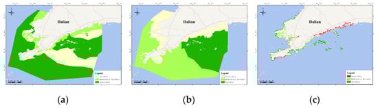
Figure 7.
Spatial suitability results of the weighting method in the coastal waters of Dalian for (a) marine ecological protection, (b) mariculture, and (c) port construction.
Overall, the selection of the extremum method has a significant impact on the final suitability evaluation results. The weighting method provides a more nuanced representation of individual indicator influences and better reflects ecological sensitivities, but it introduces additional variability and depends critically on the assumptions used in weight assignment and threshold classification. In contrast, the extremum method, while simpler and more predictable, may overlook important differences in indicator importance. Future research should therefore appropriately integrate weighting and sensitivity analysis methods while ensuring robust analytical results, thereby striking a balance between scientific rigor and practical feasibility.
5.3. Analysis of the Spatial Planning Scheme Optimization
Over the past three decades, MSP has experienced rapid development, but reconciling development with protection remains a core challenge [63,64,65]. In recent years, the Chinese government has prioritized ecological considerations in marine spatial allocations [33]. Accordingly, our optimized planning scheme identifies 22.0% of the marine area as Ecological Redline Zones and 32.4% as Ecological Control Zones. This allocation effectively preserves core ecosystem services by encompassing most areas identified as ecological “suitable” (22.8%) and “moderately suitable” (55.4%). Furthermore, integrating suitability evaluations with existing spatial patterns in multi-use areas has facilitated stakeholder negotiations, a crucial factor given the high economic stakes and diverse interests in marine spaces [10,64]. Consequently, the proposed scheme retains development functions in over 90% of current utilization zones while ensuring that each functional area aligns with its respective suitability classification and environmental protection objectives.
Currently, the spatial development suitability evaluations have already been institutionalized as an important component of territorial spatial planning [15,31,33]. Nonetheless, MSP is inherently a multi-stakeholder, continuously negotiated process, and our approach has several limitations: (i) categorizing suitability into three broad categories (suitable, moderately suitable, and unsuitable), although practical for planning, may oversimplify spatial heterogeneity; and (ii) the optimization process is closely aligned with current policies and utilization patterns, which may limit its applicability under future scenarios that demand dynamic integration of social and ecological resilience [9,66]. Future work could address these limitations by refining the suitability classification (e.g., using continuous suitability scores or additional categorical levels) and incorporating scenario-based analyses to improve the adaptability of the optimization process.
6. Conclusions
This study proposed a science-based and policy-aligned framework for implementing MSP in Dalian’s coastal waters. By addressing the spatial requirements of multiple marine activities, the framework facilitates identification of areas suitable for both ecological protection and sustainable development, enabling a comprehensive evaluation of spatial heterogeneity, functional trade-offs, and synergies. The resulting zoning scheme, comprising Ecological Redline Zones, Ecological Control Zones, and Marine Exploitation Zones, reflects both ecological value and socio-economic needs, aligning spatial management strategies with regional resource availability, environmental capacity and current use patterns. While the proposed framework provides a valuable foundation for data-driven informed MSP, its long-term effectiveness relies on the continuous refinement of ecological and socio-economic datasets, as well as the integration of predictive modeling to anticipate future ecological and anthropogenic changes. Future research should aim to further integrate systematic planning and artificial intelligence with comprehensive ecological and socio-economic datasets to enable adaptive, forward-looking MSP. Overall, this study contributes a replicable, science-based approach to MSP and offers strategic insights for implementation in coastal regions facing competing development and conservation demands.
Author Contributions
Conceptualization, L.Y. and W.L.; data curation, Z.L., Y.T. and X.W.; Formal analysis, J.L., Z.L., Y.T. and X.W.; funding acquisition, W.L. and T.W.; methodology, L.Y., W.L., R.Z., A.B. and J.L.; software, G.Z. and T.W.; visualization, G.Z. and T.W.; writing—original draft preparation, L.Y. and J.L.; writing—review and editing, R.Z., A.B. and W.L. All authors have read and agreed to the published version of the manuscript.
Funding
This research was funded by the 2024 National Statistical Science Fund of China (2024LZ024), and Key Science and Technology Innovation Program of National Marine Data and Information Service (2301GJYB01).
Institutional Review Board Statement
Not applicable.
Informed Consent Statement
Not applicable.
Data Availability Statement
Data will be made available on request.
Conflicts of Interest
The authors declare no conflicts of interest.
References
- Borja, Á.; White, M.P.; Berdalet, E.; Bock, N.; Eatock, C.; Kristensen, P.; Leonard, A.; Lloret, J.; Pahl, S.; Parga, M.; et al. Moving toward an agenda on ocean health and human health in Europe. Front. Mar. Sci. 2020, 7, 37. [Google Scholar] [CrossRef]
- Eikeset, A.M.; Mazzarella, A.B.; Davíðsdóttir, B.; Klinger, D.H.; Levin, S.A.; Rovenskaya, E.; Stenseth, N.C. What is blue growth? The semantics of “Sustainable Development” of marine environments. Mar. Policy 2018, 87, 177–179. [Google Scholar] [CrossRef]
- Lu, W.H.; Cusack, C.; Baker, M.; Wang, W.; Chen, M.B.; Paige, K.; Zhang, X.F.; Levin, L.; Escobar, E.; Amon, D.; et al. Successful blue economy examples with an emphasis on international perspectives. Front. Mar. Sci. 2019, 6, 261. [Google Scholar] [CrossRef]
- United Nations Office of Legal Affairs. The Second World Ocean Assessment; United Nations: New York, NY, USA, 2021; Volume 1. [Google Scholar]
- Elliott, M.; Borja, Á.; Cormier, R. Managing marine resources sustainably: A proposed integrated systems analysis approach. Ocean Coast. Manag. 2020, 197, 105315. [Google Scholar] [CrossRef]
- Douvere, F. The importance of marine spatial planning in advancing ecosystem-based sea use management. Mar. Policy 2008, 32, 762–771. [Google Scholar] [CrossRef]
- de Novaes Vianna, L.F.; Bonetti Filho, J. Spatial analysis for site selection in marine aquaculture: An ecosystem approach applied to Baía Sul, Santa Catarina, Brazil. Aquaculture 2018, 489, 162–174. [Google Scholar] [CrossRef]
- Wibowo, I.S.; Mashar, A.; Pratiwi, N.T.M.; Kurniawan, F. Marine Suitability Assessment for Mariculture: Combining GIS and AHP Technique in Dampier Strait Conservation Area, West Papua Province, Indonesia. J. Ilm. Perikan. Kelaut. 2023, 15, 316. [Google Scholar] [CrossRef]
- Pınarbaşı, K.; Galparsoro, I.; Depellegrin, D.; Bald, J.; Pérez-Morán, G.; Borja, Á. A modelling approach for offshore wind farm feasibility with respect to ecosystem-based marine spatial planning. Sci. Total Environ. 2019, 667, 306–317. [Google Scholar] [CrossRef]
- Wei, B.Q.; Li, Y.; Suo, A.N.; Zhang, Z.F.; Xu, Y.; Chen, Y.L. Spatial suitability evaluation of coastal zone, and zoning optimisation in Ningbo, China. Ocean Coast. Manag. 2021, 204, 105507. [Google Scholar] [CrossRef]
- Day, J.C.; Kenchington, R.A.; Tanzer, J.M.; Cameron, D.S. Marine zoning revisited: How decades of zoning the Great Barrier Reef has evolved as an effective spatial planning approach for marine ecosystem-based management. Aquat. Conserv. Mar. Freshw. Ecosyst. 2019, 29, 9–32. [Google Scholar] [CrossRef]
- Galparsoro, I.; Montero, N.; Mandiola, G.; Menchaca, I.; Borja, Á.; Flannery, W.; Katsanevakis, S.; Fraschetti, S.; Fabbrizzi, E.; Elliott, M.; et al. Assessment Tool Addresses Implementation Challenges of Ecosystem-Based Management Principles in Marine Spatial Planning Processes. Commun. Earth Environ. 2025, 6, 55. [Google Scholar] [CrossRef]
- EU. Directive 2014/89/EU of the European Parliament and of the Council of 23 July 2014, Establishing a Framework for Maritime Spatial Planning; European Union: Brussels, Belgium, 2014. [Google Scholar]
- UNESCO-IOC; European Commission. MSP Global International Guide on Marine/Maritime Spatial Planning; UNESCO: Paris, France, 2021. [Google Scholar]
- Ma, R.F.; Ji, S.W.; Ma, J.W.; Shao, Z.H.; Zhu, B.Y.; Ren, L.Y.; Li, J.M.; Liu, L.D. Exploring resource and environmental carrying capacity and suitability for use in marine spatial planning: A case study of Wenzhou, China. Ocean Coast. Manag. 2022, 226, 106258. [Google Scholar] [CrossRef]
- Chi, Y.; Liu, D.H.; Wang, C.J.; Xing, W.X.; Gao, J.H. Island development suitability evaluation for supporting the spatial planning in archipelagic areas. Sci. Total Environ. 2022, 829, 154679. [Google Scholar] [CrossRef]
- Han, Y.; Zhu, J.F.; Wei, D.L.; Wang, F.X. Spatial–temporal effect of sea–land gradient on landscape pattern and ecological risk in the coastal zone: A case study of Dalian City. Open Geosci. 2024, 16, 20220722. [Google Scholar] [CrossRef]
- Xu, S.C.; Qiao, Y.L.; Xu, S.A.; Yue, S.D.; Zhang, Y.; Liu, M.J.; Zhang, X.M.; Zhou, Y. Diversity, distribution and conservation of seagrass in coastal waters of the Liaodong Peninsula, North Yellow Sea, northern China: Implications for seagrass conservation. Mar. Pollut. Bull. 2021, 167, 112261. [Google Scholar] [CrossRef]
- Chan, S.; Crosby, M.; So, S.; Wang, D.Z.; Cheung, F.; Hua, F.Y. Directory of Important Bird Areas in China (Mainland): Key Sites for Conservation; BirdLife International: Cambridge, UK, 2009. [Google Scholar]
- Ministry of Agriculture. Map of marine fishery waters of China (first batch): Map of fishery waters of Yellow Sea and Bohai Sea (first batch). China Fish. 2002, 8, 17–19. [Google Scholar]
- Wang, P.L.; Han, J.B.; Ma, Z.Q. Status survey of spotted seal (Phoca largha) in Bohai and Yellow Sea. Chin. J. Wildl. 2008, 29, 29–31,39. [Google Scholar]
- Zhang, B.; Wang, Q. Heritage-Based Spatial Form Consideration: Western Urban Planning Concepts Used in Chinese Urban (Dalian) Development. Sustainability 2023, 15, 10899. [Google Scholar] [CrossRef]
- Zhou, L.Y.; Zhou, D.; Chen, M.; He, J.; Pei, Z.B. The zoning of marine ecological space use control in Dalian. Ocean Dev. Manag. 2021, 38, 19–25. [Google Scholar]
- Gai, M.; Yue, P.; Yang, Q.F. Assessment of marine ecological environment and identification of influencing factors in the Bohai Rim region. Resour. Sci. 2022, 44, 1645–1662. [Google Scholar] [CrossRef]
- Yue, Q.; Zhu, Q.L.; Liu, N.N.; Xu, W.; Dong, Y.E. Retrospective evaluation of China′s marine functional zoning and new round of preparation recommendations. Ocean Dev. Manag. 2019, 36, 3–7. [Google Scholar]
- Teng, X.; Zhao, Q.W.; Zhang, P.P.; Liu, L.; Dong, Y.E.; Hu, H.; Yue, Q.; Ou, L.; Xu, W. Implementing marine functional zoning in China. Mar. Policy 2021, 132, 103484. [Google Scholar] [CrossRef]
- Fang, Q.H.; Zhang, R.; Zhang, L.P.; Hong, H.S. Marine functional zoning in China: Experience and prospects. Coast. Manag. 2011, 39, 656–667. [Google Scholar] [CrossRef]
- Lu, W.H.; Liu, J.; Xiang, X.Q.; Song, W.L.; McIlgorm, A. A comparison of marine spatial planning approaches in China: Marine functional zoning and the marine ecological red line. Mar. Policy 2015, 62, 94–101. [Google Scholar] [CrossRef]
- Huang, F.M.; Lin, Y.H.; Liang, H.X.; Zhao, R.R.; Chen, Q.M.; Lin, J.; Huang, J.L. Coordination of Marine Functional Zoning Revision at the Provincial and Municipal Levels: A Case Study of Putian, China. J. Mar. Sci. Eng. 2019, 7, 442. [Google Scholar] [CrossRef]
- State Council of PRC. Opinions of the CPC Central Committee and the State Council on the Establishment and Supervision of Territorial Space Planning System. 2019. Available online: https://www.gov.cn/gongbao/content/2019/content_5397679.htm (accessed on 24 February 2025).
- Liu, Y.; Zhou, Y. Territory spatial planning and national governance system in China. Land Use Policy 2021, 102, 105288. [Google Scholar] [CrossRef]
- Zeng, R.; Xu, Y.; Yang, L.; Ai, Y.Y.; Liu, J.; Liu, C.; Lu, W.H. Adjustment of the marine ecological red lines in China. Sci. Rep. 2024, 14, 19247. [Google Scholar] [CrossRef] [PubMed]
- The State Council Information Office of PRC. Marine Eco-Environmental Protection in China. 2024. Available online: http://english.scio.gov.cn/m/whitepapers/2024-07/11/content_117302527.htm (accessed on 24 February 2025).
- KBA Standards and Appeals Committee. Guidelines for Using A Global Standard for the Identification of Key Biodiversity Areas: Version 1.1; Gland, IUCN: Gland, Switzerland, 2020. [Google Scholar]
- Secretariat of the Convention on Biological Diversity. Azores Scientific Criteria and Guidance for Identifying Ecologically or Biologically Significant Marine Areas and Designing Representative Networks of Marine Protected Areas in Open Ocean Waters and Deep Sea Habitats. 2009. Available online: https://www.cbd.int/marine/doc/azores-brochure-en.pdf (accessed on 24 February 2025).
- Liquete, C.; Zulian, G.; Delgado, I.; Stips, A.; Maes, J. Assessment of coastal protection as an ecosystem service in Europe. Ecol. Indic. 2013, 30, 205–217. [Google Scholar] [CrossRef]
- Hilmi, N.; Chami, R.; Sutherland, M.D.; Hall-Spencer, J.M.; Lebleu, L.; Benitez, M.B.; Levin, L.A. The role of blue carbon in climate change mitigation and carbon stock conservation. Front. Clim. 2021, 3, 710546. [Google Scholar] [CrossRef]
- Dapueto, G.; Massa, F.; Costa, S.; Cimoli, L.; Olivari, E.; Chiantore, M.; Federici, B.; Povero, P. A spatial multi-criteria evaluation for site selection of offshore marine fish farm in the Ligurian Sea, Italy. Ocean. Coast. Manag. 2015, 116, 64–77. [Google Scholar] [CrossRef]
- Buck, B.H.; Langan, R. Aquaculture Perspective of Multi-Use Sites in the Open Ocean: The Untapped Potential for Marine Resources in the Anthropocene; Springer Nature: Cham, Switzerland, 2017. [Google Scholar]
- Dale, T.; Cusack, C.; Ruiz, M. Aquaculture Site Selection Report; AtlantOS Deliverable, D8.2: Kiel, Germany, 2017. [Google Scholar] [CrossRef]
- Huang, P. Research on the evaluation system of coastal basic function suitability zoning. Ocean Dev. Manag. 2013, 30, 18–22. [Google Scholar]
- Guo, X.J.; Wang, H.M.; Shi, Y.J. Evaluation on port shoreline resources of Yangtze River Estuary based on multi natural factors. Yangtze River 2018, 49, 1–7. [Google Scholar]
- Liu, Z.Y.; Yang, L.; Zhang, J.; Zuo, G.C.; Zhang, Y.J. Analysis on the suitability for port construction of shoreline resources of Zhoushan Archipelago. IOP Conf. Ser. Earth Environ. Sci. 2020, 612, 012074. [Google Scholar] [CrossRef]
- van Cleve, F.B.; Judd, C.; Radil, A.; Ahmann, J.; Geerlofs, S.H. Geospatial Analysis of Technical and Economic Suitability for Renewable Ocean Energy Development on Washington’s Outer Coast; Pacific Northwest National Laboratory: Richland, WA, USA, 2013. [Google Scholar]
- Wang, G.S.; Gao, S.H.; Wu, B.G.; Hou, M.; Xie, Y.Y. Distribution features of wind energy resources in the offshore areas of China. Adv. Mar. Sci. 2014, 32, 21–29. [Google Scholar]
- Vinhoza, A.; Schaeffer, R. Brazil’s offshore wind energy potential assessment based on a Spatial Multi-Criteria Decision Analysis. Renew. Sustain. Energy Rev. 2021, 146, 111185. [Google Scholar] [CrossRef]
- Zhang, J.H.; Wang, H. Development of offshore wind power and foundation technology for offshore wind turbines in China. Ocean Eng. 2022, 266, 113256. [Google Scholar] [CrossRef]
- Liu, B.Q.; Xu, M.; Liu, Q. Key Issues and Policy Recommendations for Offshore Wind Power Development in China. Ocean Dev. Manag. 2015, 3, 7–12. [Google Scholar]
- Feng, Y.J.; Zheng, Z.K. Suitability evaluation of Ningbo Marine Tourism Recreation and Improvement of functional zoning. Dev. Manag. 2017, 34, 92–96. [Google Scholar]
- Ma, Z.Q.; Han, J.B.; Jiang, D.W.; Zhang, W. Population dynamics of spotted seals in the waters around Huping Island in Bohai Sea. Fish. Sci. 2007, 26, 455–457. [Google Scholar]
- Shi, X.; Liu, Y.G.; Qiao, S.Q.; Liu, S.F.; Wang, K.S. Sediment Type Map of the Bohai Sea, Yellow Sea and East China Sea; Science Press: Beijing, China, 2022. [Google Scholar]
- GB 11607-89; Water quality standard for fisheries. National Environmental Protection Agency: Beijing, China, 1989.
- GB/T 18710-2002; Methodology of wind energy resource assessment for wind farm. General Administration of Quality Supervision, Inspection and Quarantine: Beijing, China, 2002.
- HY/T 0273-2019; Technical directives for risk assessment and zoning of marine disaster Part I: Storm surge. Ministry of Natural Resources: Beijing, China, 2019.
- Jenks, G.F. The data model concept in statistical mapping. Int. Yearb. Cartogr. 1967, 7, 186–190. [Google Scholar]
- Osaragi, T. Classification Methods for Spatial Data Representation; Centre for Advanced Spatial Analysis (UCL): London, UK, 2002. [Google Scholar]
- Zhuang, H.F.; Lu, Z.C.; Liu, Z.L.; Wang, Z.L.; Zhao, L.L. Study on the ecological corridor of spotted seals in the Bohai and Yellow Seas. Natl. Park 2024, 2, 81–90. [Google Scholar] [CrossRef]
- Shine, R.; Sun, L.X.; Zhao, E.; Bonnet, X. A review of 30 years of ecological research on the Shedao Pitviper, Gloydius shedaoensis. Herpetol. Nat. Hist. 2002, 9, 1–14. [Google Scholar]
- IUCN. The IUCN Red List of Threatened Species. Version 202401. 2024. Available online: https://www.iucnredlist.org (accessed on 1 October 2024).
- Borja, Á.; Pouso, S.; Galparsoro, I.; Manca, E.; Vasquez, M.; Lu, W.H.; Yang, L.; Uriarte, A. Applying the China’s marine resource-environment carrying capacity and spatial development suitability approach to the Bay of Biscay (North-East Atlantic). Front. Mar. Sci. 2022, 9, 972448. [Google Scholar] [CrossRef]
- Korpinen, S.; Laamanen, L.; Bergström, L.; Nurmi, M.; Andersen, J.H.; Haapaniemi, J.; Harvey, E.T.; Murray, C.J.; Peterlin, M.; Kallenbach, E.; et al. Combined effects of human pressures on Europe’s marine ecosystems. Ambio 2021, 50, 1325–1336. [Google Scholar] [CrossRef]
- Dong, W.W.; Lin, G.L.; Lu, H.Q. Assessment of the suitability of marine land spatial development and the delineation of its functional areas: Take the sea area of Putian City as an example. Territ. Nat. Resour. Study 2025, 2, 28–35. [Google Scholar]
- Chalastani, V.I.; Tsoukala, V.K.; Coccossis, H.; Duarte, C.M. A bibliometric assessment of progress in marine spatial planning. Mar. Policy 2021, 127, 104329. [Google Scholar] [CrossRef]
- Ehler, C.N. Two decades of progress in Marine Spatial Planning. Mar. Policy 2021, 132, 104134. [Google Scholar] [CrossRef]
- Santos, C.F.; Agardy, T.; Andrade, F.; Crowder, L.B.; Ehler, C.N.; Orbach, M.K. Major challenges in developing marine spatial planning. Mar. Policy 2021, 132, 103248. [Google Scholar] [CrossRef]
- Noble, M.M.; Harasti, D.; Pittock, J.; Doran, B. Linking the social to the ecological using GIS methods in marine spatial planning and management to support resilience: A review. Mar. Policy 2019, 108, 103657. [Google Scholar] [CrossRef]


Disclaimer/Publisher’s Note: The statements, opinions and data contained in all publications are solely those of the individual author(s) and contributor(s) and not of MDPI and/or the editor(s). MDPI and/or the editor(s) disclaim responsibility for any injury to people or property resulting from any ideas, methods, instructions or products referred to in the content. |
© 2025 by the authors. Licensee MDPI, Basel, Switzerland. This article is an open access article distributed under the terms and conditions of the Creative Commons Attribution (CC BY) license (https://creativecommons.org/licenses/by/4.0/).