Article

Modular Design Strategies for Community Public Spaces in the Context of Rapid Urban Transformation: Balancing Spatial Efficiency and Cultural Continuity

College of International Communication and Art, Hainan University, Haikou 570228, China
*
Author to whom correspondence should be addressed.
Sustainability 2025, 17(16), 7480; https://doi.org/10.3390/su17167480
Submission received: 16 June 2025 / Revised: 5 August 2025 / Accepted: 14 August 2025 / Published: 19 August 2025

Abstract

This study explores the application of modular design in the regeneration of community public spaces within rapidly transforming urban environments, using Haikou as a case study. The objective is to improve spatial quality and community sustainability while preserving cultural identity and community engagement. Through a mixed-methods approach involving questionnaires, GIS-based spatial analysis, and case studies, the research identifies key challenges such as fragmented layouts, limited accessibility, and insufficient green space. In response, a “policy–design–community” integration mechanism is proposed to guide bottom-up and top-down coordination. A multidimensional evaluation framework is developed to assess the effectiveness of modular interventions across functional, spatial, and cultural dimensions. The findings suggest that modular design—owing to its standardization and flexibility—enhances spatial adaptability and construction efficiency, and strengthens cultural identity and community engagement. This research provides a replicable and data-informed strategy for the renewal of public spaces in Chinese urban environments.

1. Introduction

Amid rapid urbanization across the Global South, community-scale public spaces are facing unprecedented spatial pressures and structural challenges [1,2]. Urban renewal and land development strategies often prioritize macro-level spatial configurations, industrial clusters, and real estate growth, frequently overlooking the diverse needs and cultural values embedded in micro-scale public spaces [3,4]. This top-down planning logic results in the marginalization, fragmentation, and functional erosion of these vital communal environments [5]. In second-tier Chinese cities such as Haikou, this issue is particularly pronounced. As part of the Hainan Free Trade Port initiative, Haikou has experienced accelerated spatial expansion and a sharp population increase, revealing significant shortcomings in the layout, function, and cultural integration of its community public spaces.
These deficiencies manifest across three dimensions. First, spatial fragmentation: many public spaces occupy leftover or irregular land parcels between residential blocks, lacking continuity and coherence to support integrated community life [6,7]. Second, functional monotony: most spaces are limited to simple green buffers or pocket plazas, unable to accommodate multi-generational or multifunctional needs, rendering them inflexible and underutilized [8,9]. Third, cultural discontinuity: elements of historical memory, local symbols, and spatial identity are disappearing, leaving culturally void spaces that weaken residents’ sense of belonging and reduce the socio-cultural vitality of neighborhoods [10,11,12].
Internationally, community public spaces are increasingly recognized as critical to advancing urban equity, resilience, and well-being [13,14]. These spaces serve as green micro-infrastructure and facilitate neighborhood interactions, cultural expression, and intergenerational connections [15]. A growing body of research confirms that well-designed public spaces can enhance physical activity and cognitive engagement among older adults, support cultural inclusion for migrants, and improve spatial access for marginalized communities—thus promoting urban justice [16]. Consequently, such spaces must be reimagined not as passive remnants of urban form, but as strategic platforms for inclusive governance and cultural continuity. In recent years, modular design has gained attention as a transformative spatial intervention strategy [17]. It combines digital fabrication [18], parametric modeling [19], and standardized components to enable fast [20,21], adaptive, and resource-efficient construction. Although widely applied in sectors such as housing, healthcare, and education [22,23,24], its potential in the design and regeneration of community public spaces remains underexplored. The strengths of modular design—flexibility, scalability, and speed—make it particularly suitable for dynamic urban contexts marked by demographic fluidity and uncertain planning horizons [25]. Global precedents have shown that modular elements such as service kiosks, moveable furniture, and adaptive pavilions can effectively enhance urban livability and social inclusivity [26,27,28]. More specifically, several case-based studies illustrate the diverse potential of modular public space design across regions. In Canada, Philip operationalized SDG 11.3.1 through community-scale planning to enhance land use efficiency and spatial equity [29]. In South Korea, Lee et al. investigated modular public rental housing and its influence on neighborhood open spaces, offering insights into how standardized spatial units can improve accessibility and adaptability [30]. In India, Munmulla et al. demonstrated that modular infrastructure can address urban heat islands and enhance walkability in informal settlements [31]. While these studies present important innovations, they primarily emphasize environmental performance and spatial efficiency, with less focus on cultural embedding. Furthermore, their policy contexts often assume stable governance structures and high levels of civic participation, which limits the applicability of their approaches to rapidly transforming Chinese cities, where administrative rationality and demographic flux dominate. This highlights the need for localized and culturally integrated approaches.
More critically, modular design has the potential to embed cultural meaning. Through its forms, materials, motifs, and participatory design processes, modular systems can act as carriers of cultural narratives—bridging tradition and innovation, form and emotion [32,33]. Yet, in Chinese urban practice, the use of modular design is mostly limited to residential or temporary structures, lacking systematic application within community public space contexts [34]. Moreover, theoretical work and empirical research that examine the cultural dimensions of modularity remain sparse. Most existing frameworks do not regard cultural continuity as a central objective in modular planning [35,36]. Cultural continuity refers to the capacity of communities to preserve and transmit their collective values, identities, and social practices amid rapid urban and social transformation [37,38]. Public spaces, as physical anchors of everyday life, are crucial for enabling such continuity [39]. However, current modular design practices often reduce culture to superficial decoration or abstract symbolism, rather than treating it as an embedded spatial logic [40]. Addressing this gap—by integrating cultural continuity into the core objectives of modular design and shifting from technical modularity to culturally informed spatial strategies—is a critical agenda for contemporary urban regeneration.
To advance this agenda, this study explores two central research questions: (1) How can modular design strategies support the sustainable regeneration of community public spaces in rapidly transforming cities by addressing spatial, social, and ecological challenges? (2) How can principles of cultural continuity be embedded into the design, construction, and deployment of modular systems to foster culturally resonant and socially inclusive public spaces? These questions reflect two major shortcomings in existing literature: the absence of culturally grounded modular strategies and the lack of context-responsive public space regeneration models in Chinese cities. To address these issues, this research adopts Haikou as a case study and proposes a data-informed modular intervention framework for community public space renewal. The framework integrates three methodological components: (1) remote sensing and GIS analysis to identify spatial inefficiencies, ecological vulnerabilities, and accessibility deficits; (2) community-based surveys and interviews to assess user needs, cultural preferences, and behavioral patterns; (3) prototype modular designs and a multi-criteria evaluation system to generate adaptive, inclusive, and culturally expressive interventions. Based on these components, the study proposes a “Policy–Design–Community” tripartite coupling mechanism to enable vertical coordination and horizontal collaboration [29,41].
This study makes four key contributions. First, at the methodological level, it integrates geospatial analysis, participatory data, and design prototyping into a holistic model addressing ecological, social, and spatial factors. Second, at the theoretical level, it articulates a framework linking modular design with cultural continuity, enriching the conceptual basis for context-responsive design. Third, at the practical level, it proposes an evaluation system and design standards that bridge the gap between spatial analysis and real-world implementation. Fourth, at the institutional level, it outlines collaborative mechanisms between governments, communities, and design teams to support scalable modular interventions. The remainder of this paper is structured as follows. Section 2 details the research scope and methodology. Section 3 presents the spatial analysis findings and key challenges. Section 4 introduces the modular design strategies, evaluation logic, and proposed prototypes. Section 5 discusses cultural embedding, applicability, and scalability. Section 6 concludes with research contributions and future directions.

2. Methods

The core focus of this study is on community public spaces in Haikou, specifically including open-access areas such as streets, plazas, and residential courtyards. To comprehensively analyze the current conditions and challenges of public spaces in the city, three representative areas were selected as case study sites (Figure 1). These areas respectively represent a traditional neighborhood, an aging residential district, and a deteriorating commercial block—three predominant types of community public spaces commonly found in Haikou. The study adopts a comparative and integrative approach based on these areas to identify generalizable problems and patterns. The findings aim to provide both empirical data and theoretical grounding to support the subsequent design strategies.

2.1. Study Area and Spatial Context

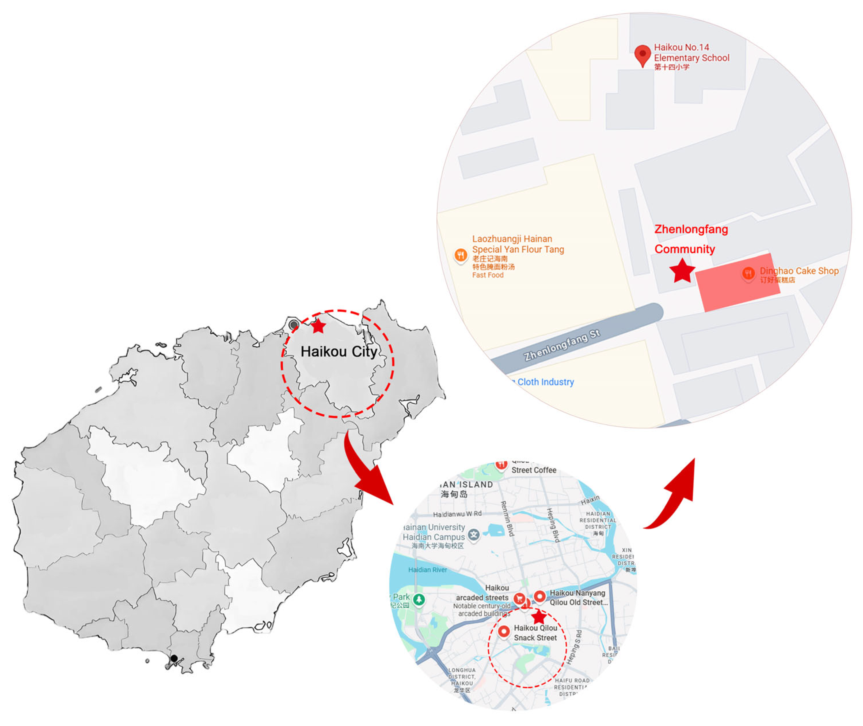
To examine the applicability of modular strategies in rapidly transforming urban settings, this study selects three representative communities in Haikou as case areas: Qilou Historic District, Chengxi Subdistrict, and Guomao Subdistrict. These districts exemplify the spatial heterogeneity encountered in second-tier Chinese cities amid urban expansion [42]—from the decline of cultural spaces in historic cores, to the ecological infrastructure gaps in peri-urban zones, and to the rigidity and congestion of high-density commercial centers. As shown in Figure 1, the study area is contextualized through a multi-level mapping structure: starting from the national scale to locate Haikou, zooming in on the urban morphology, and finally highlighting the locations, boundaries, and spatial characteristics of the three selected districts. This layered cartographic representation enables a perspective essential for geospatial analysis and subsequent design strategy formulation. The Qilou Historic District features intricate street networks and historically layered spaces such as temples, theatres, and arcaded commercial corridors—serving as a repository of local memory and cultural identity. Chengxi represents a transitional urban zone characterized by weak infrastructure, fragmented land use, and a high prevalence of edge spaces and temporary structures. Guomao, by contrast, is the city’s administrative and commercial core, marked by oversized and rigid public spaces that often lack accessibility, human scale, and adaptive function.
Such spatial diversity provides a robust testing ground for evaluating modular design responses across varying spatial configurations, cultural contexts, and demographic structures. All three districts were included in the spatial analysis and community survey, allowing the research to identify distinct challenges and common patterns across different urban typologies. However, in the design intervention stage, the Qilou Historic District was selected as the primary focus area. This decision was informed by its high cultural significance, concentration of public spaces, and strong community feedback during the survey process. As such, the Qilou area serves as a representative pilot site for validating the adaptability, inclusivity, and cultural embedding capacity of modular design strategies in a heritage-sensitive context.

2.2. Methodological Framework

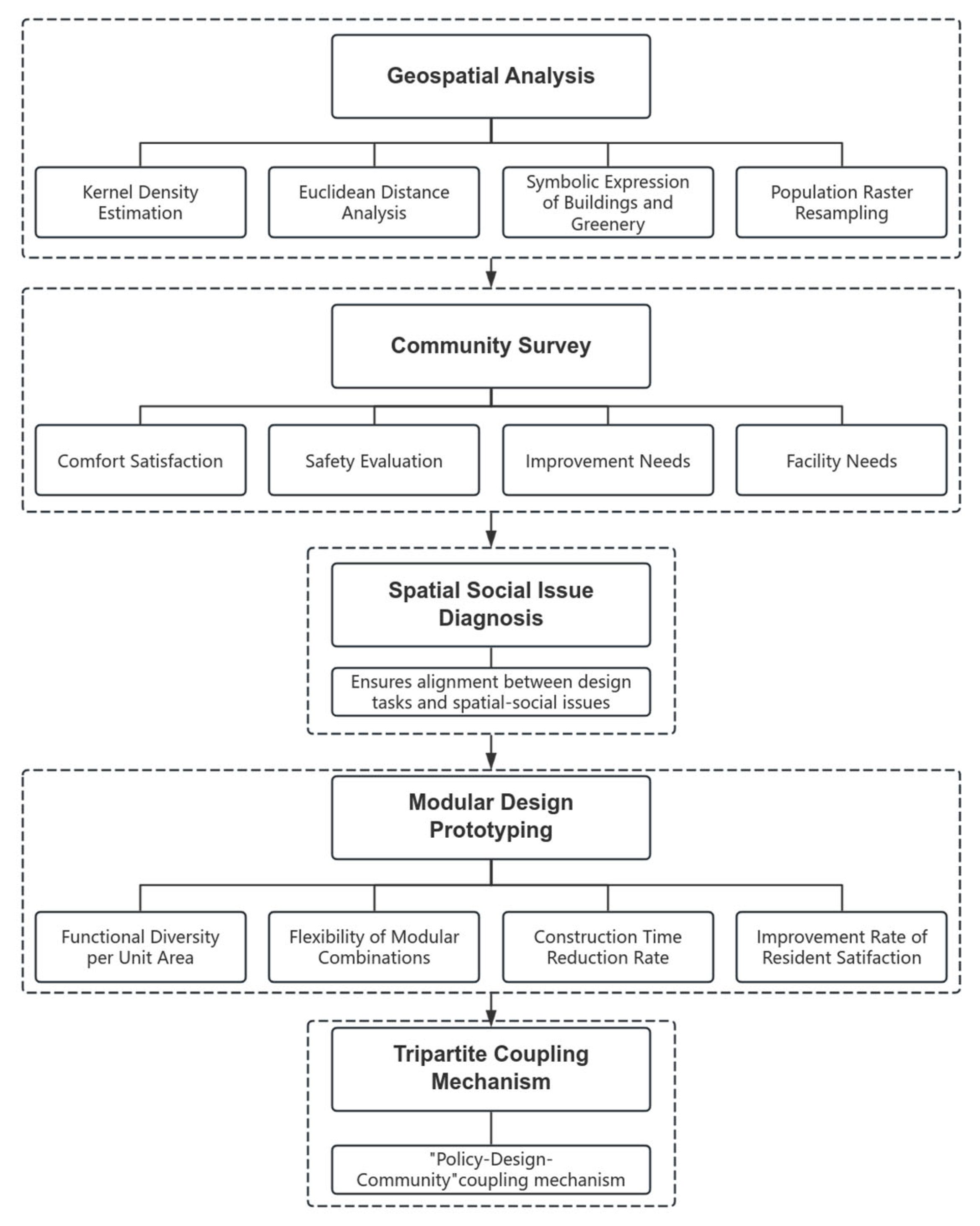
To address the complex challenges of community public space regeneration in rapidly transforming urban contexts, this study adopts a multi-phase methodological framework integrating geospatial analysis, community participation, spatial diagnosis, modular design prototyping, and implementation coupling. This framework ensures a logical progression from data collection to actionable design, aligning spatial and social analysis with context-responsive interventions.
Phase 1: Geospatial Analysis
High-resolution spatial datasets—including GF-2 satellite imagery (2023), 1:5000 land use vector maps, OpenStreetMap road networks, and WorldPop population rasters—were processed using ArcGIS to evaluate spatial efficiency, accessibility, and environmental quality across the three study districts. Four specific methods were employed:
Kernel Density Estimation: The Kernel Density tool was applied to facility point data (e.g., schools, hospitals, commercial centers), with weights assigned based on attributes such as building area or capacity. This produced facility density maps that revealed spatial disparities—for instance, lower facility intensity in Chengxi and Guomao—thereby identifying areas in need of intervention.
Euclidean Distance to Road Networks: The Euclidean Distance tool was used to compute the proximity of each pixel to the nearest road segment, enabling the evaluation of traffic accessibility and potential constraints on space utilization. Variations in pixel size were adjusted for precision and efficiency across districts.
Symbolic Mapping of Built-Up and Green Space: Built and green space layers were symbolized by type (e.g., heritage buildings, residential blocks, parks, forests) to visually map the urban ecological structure. This clarified spatial patterns such as greenery-deficient zones in Chengxi and high-density built environments in Qilou.
Population Raster Resampling: WorldPop raster data were resampled using bilinear interpolation to improve resolution and smooth population distribution gradients. This enabled more refined demographic mapping, revealing high-density clusters and informing assessments of pressure on public space.
These spatial analyses, detailed in Section 3, served as a foundational diagnostic tool for identifying target areas with weak infrastructure, ecological gaps, and high user demand, thereby guiding both community engagement and design positioning.
Phase 2: Community Survey
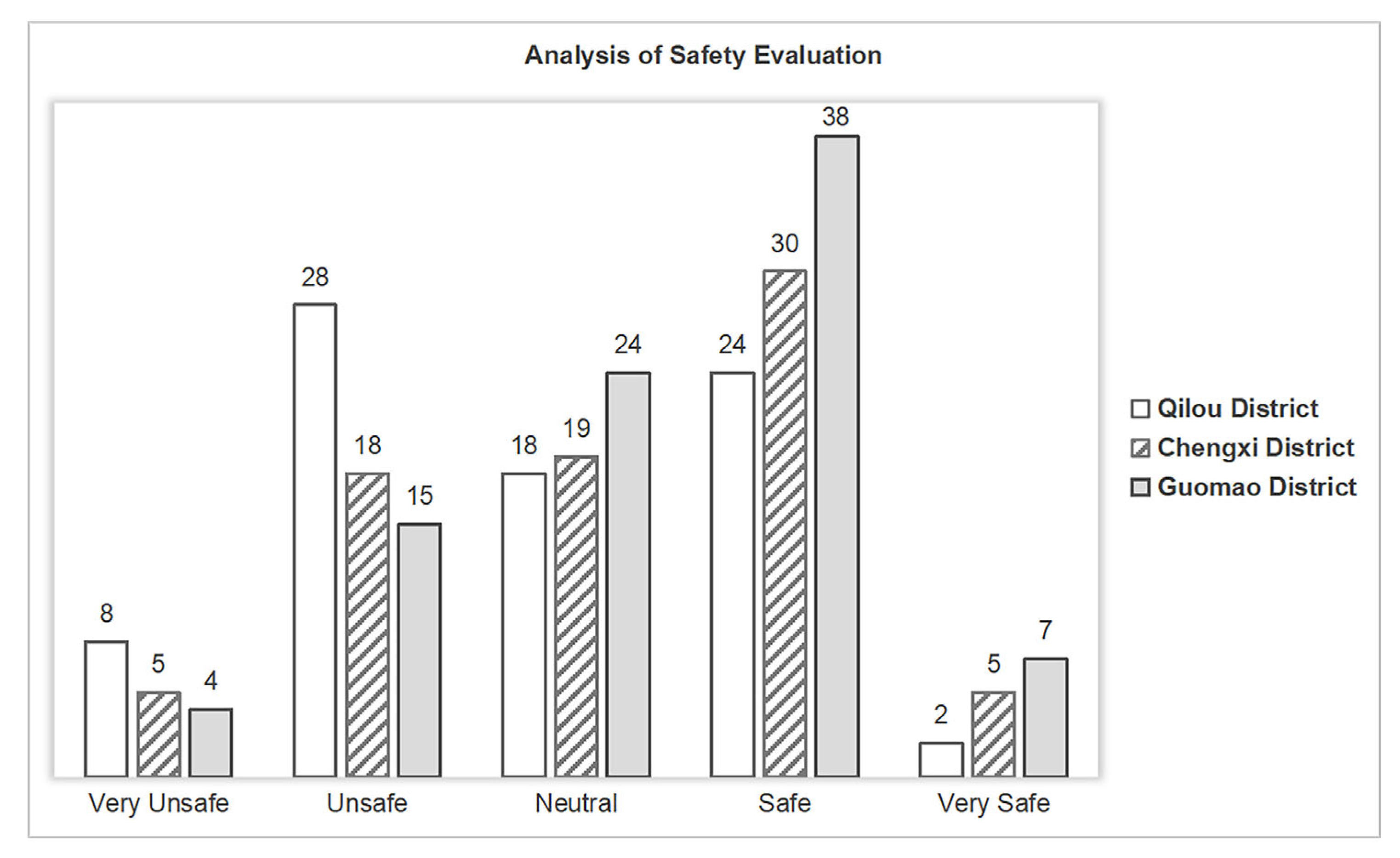
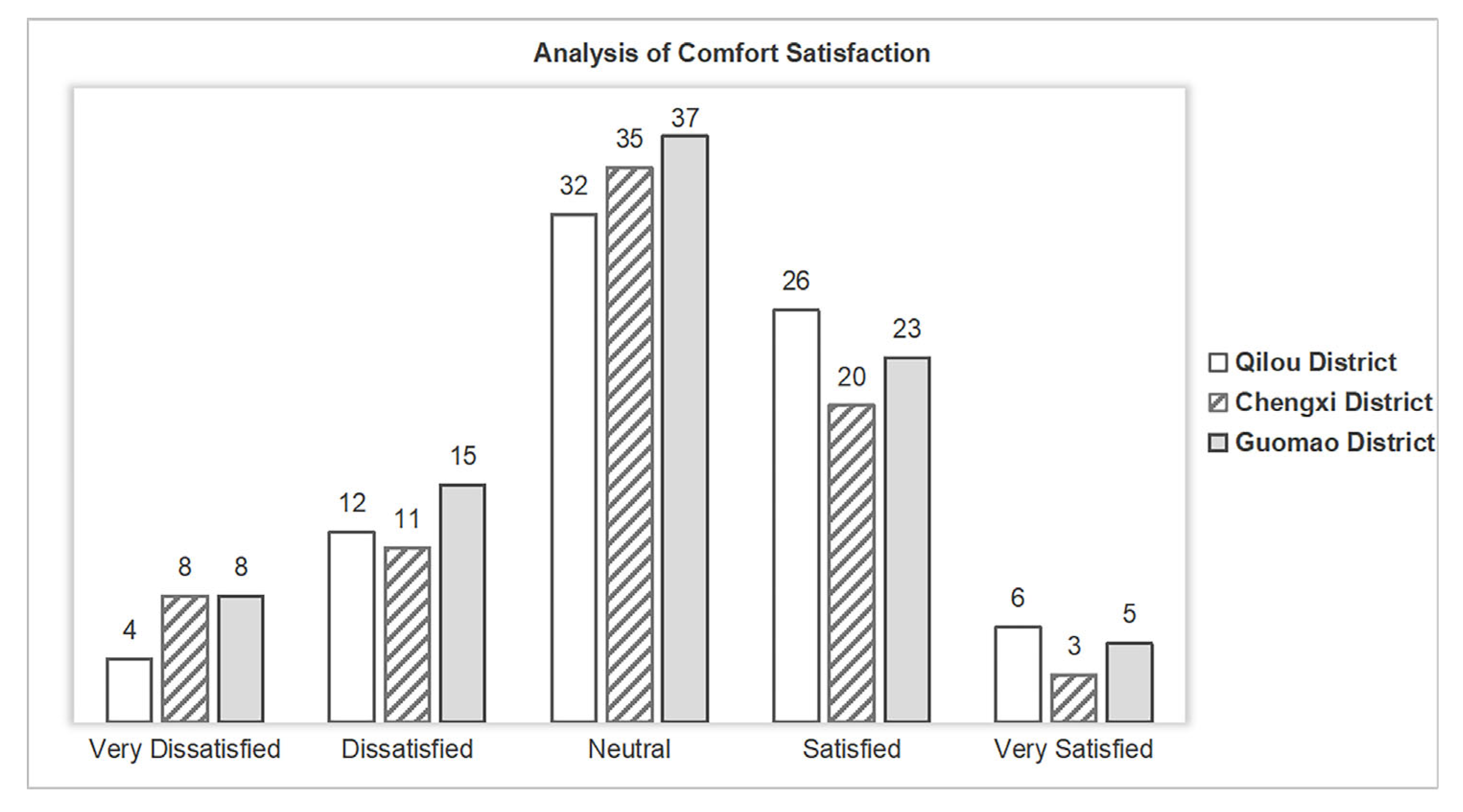
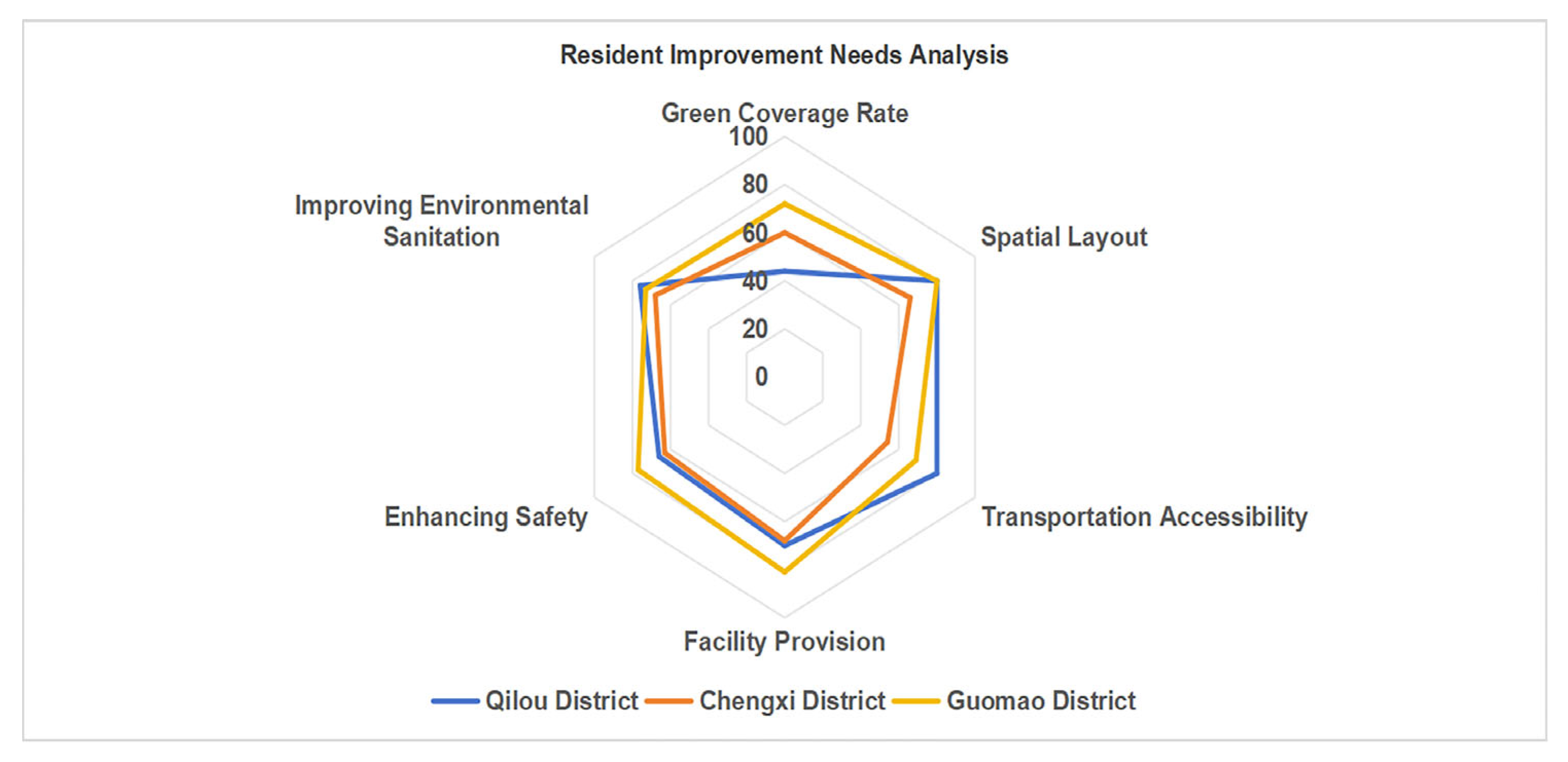
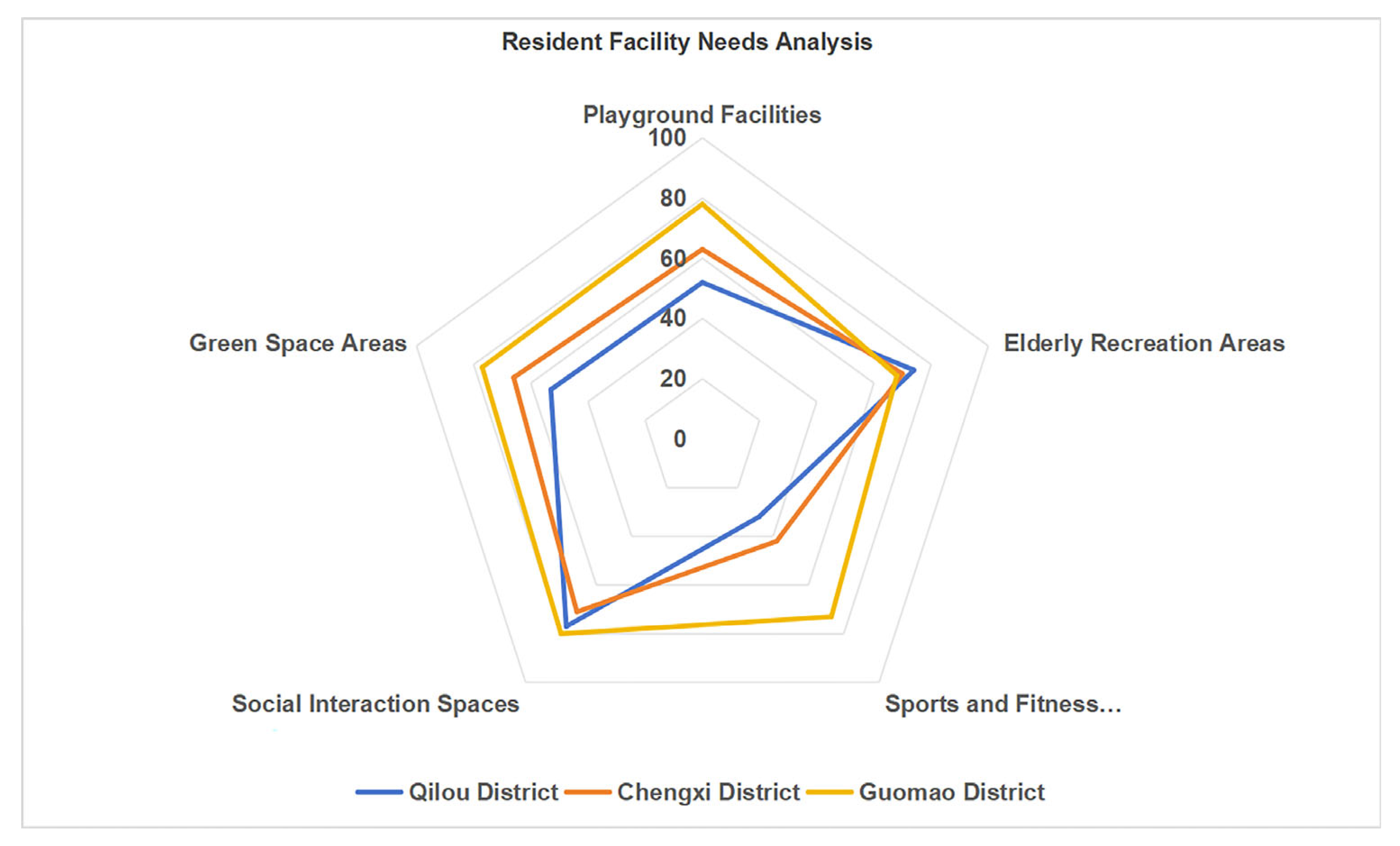
To incorporate user perspectives into the regeneration strategy, a structured questionnaire was administered across the three districts, yielding 245 valid responses from a total of 300 distributed forms. The sampling strategy followed a zonal distribution approach combined with on-site convenience sampling at residential clusters and public gathering points, ensuring coverage of diverse user groups across Qilou, Chengxi, and Guomao. Among the respondents, 133 were female (54%) and 112 male (46%). Age distribution was as follows: 32% aged 20–40, 28% aged 40–60, and 40% aged 60 or above, including a subset of solitary elderly individuals. In terms of occupational and social representation, the sample included retirees, self-employed vendors, and working-age residents engaged in both office and service sectors, which together reflect the heterogeneous socio-economic structure of the study areas. The survey addressed four core dimensions: (1) comfort satisfaction, (2) safety perception, (3) improvement priorities, and (4) facility needs. These variables were visualized through bar and radar charts (Figure 2, Figure 3, Figure 4 and Figure 5), forming the empirical basis for the spatial diagnosis and design criteria.
The survey results revealed that most residents rated the comfort level of public spaces as “average.” While a considerable number of respondents provided positive feedback, there remains substantial room for improvement. Regarding safety, residents in the Guomao area expressed relatively high satisfaction, with over 50% indicating that safety conditions were good. In contrast, respondents from the Qilou area raised concerns about traffic congestion and the deterioration of historical buildings. As for areas requiring improvement, residents across all three districts emphasized the urgent need to enhance environmental sanitation, spatial organization, and green coverage. These concerns were particularly pronounced in the Qilou and Chengxi districts, where issues related to cleanliness and vegetation were frequently mentioned. In terms of facility needs, residents called for the addition of children’s playgrounds, recreational areas for the elderly, and outdoor fitness equipment. These demands were especially strong in the Chengxi and Guomao areas, where both senior and younger populations highlighted the lack of age-friendly and activity-oriented infrastructure
Phase 3: Spatial and Social Diagnosis
This phase triangulated geospatial analysis and survey data to identify core issues in each district. For example, Qilou displayed moderate spatial continuity but low safety perception, while Chengxi showed high fragmentation and limited ecological infrastructure. These cross-validated insights informed the formulation of site-specific design briefs, ensuring consistency between diagnostic findings and intervention logic.
Phase 4: Modular Design Prototyping
Building on the identified challenges, a set of modular strategies was developed emphasizing flexibility, cultural integration, and replicability. Design elements included shaded seating modules, interactive installations, and culturally contextualized microstructures. A multi-criteria evaluation framework was applied, based on four performance indicators: (1) Functional Diversity per Unit Area, (2) Flexibility of Modular Combinations, (3) Construction Time Reduction Rate, and (4) Improvement Rate of Resident Satisfaction. These metrics ensured that design proposals directly addressed the spatial and social inefficiencies diagnosed in earlier phases. The prototyping outcomes are elaborated in Section 4.
Phase 5: Coupling Mechanism Formulation
To ensure institutional scalability and local adaptability, a “Policy–Design–Community” tripartite coupling mechanism was proposed. This mechanism aligns top-down planning with bottom-up participation and design iteration, aiming to bridge the typical implementation gap in transitional urban settings. Section 5 elaborates how this model supports modular deployment across varying spatial and administrative conditions. To enhance transparency and clarity, Figure 6 illustrates the complete research workflow, showing the functional linkages among geospatial analysis, community feedback, and design strategies.

2.3. Data Sources and Processing

To support the spatial diagnostics and modular design framework, this study integrates four categories of data. All datasets were processed using ArcGIS 10.8, Excel, and SPSS 27.0, ensuring consistency, reproducibility, and analytic depth.
(1)
Spatial Datasets
High-resolution satellite imagery was obtained from Gaofen-2 (1 × 1 m2, 2023) to assess land cover and surface features. A 1:5000 land use vector map, provided by the Haikou Urban Planning Bureau, was used to classify spatial functions and identify underutilized parcels. Road network data was sourced from OpenStreetMap and manually corrected to enhance topological accuracy.
(2)
Population Raster Data
Demographic data was retrieved from the WorldPop 2020 China dataset, with a native resolution of 100 m. To enhance spatial granularity, the raster was resampled to 50 m using bilinear interpolation, which ensured a smoother and more accurate representation of population distribution. These resampled layers supported finer-scale analyses of population density variations within each study area.
(3)
Community Survey Data
A structured questionnaire was administered in the three selected districts, yielding a total of 245 valid responses out of 300 distributed. The instrument was divided into four modules: comfort satisfaction, perceived safety, improvement needs, and facility preferences. Survey responses were coded using Likert scales and categorical variables, anonymized for privacy, and processed using Excel and IBM SPSS Statistics 26.0 (IBM Corp., Armonk, NY, USA) for subsequent analysis and visualization. The questionnaire design and variable structure are detailed in Section 2.2.
(4)
Supplementary Planning and Policy Documents
To align the spatial and social findings with regulatory and institutional frameworks, this study reviewed urban development guidelines issued by the Haikou Municipal Government, strategic documents under the Hainan Free Trade Port initiative, and transcripts from on-site interviews conducted during field visits. These references provided essential context for evaluating the feasibility and scalability of modular public space interventions.

2.4. Evaluation Logic and Design Criteria

To ensure that the proposed modular design strategies are both evidence-based and context-sensitive, this study establishes an evaluation framework comprising four core indicators. Each indicator is directly derived from the spatial and social analyses conducted in earlier stages and is used to assess the performance of design prototypes in addressing current public space deficiencies.
(1)
Functional Diversity per Unit Area
This indicator measures the number of distinct functional modules (e.g., play, rest, fitness, gathering) integrated into a spatial prototype, normalized by unit area (m2). It reflects the efficiency and versatility of space utilization.
(2)
Flexibility of Modular Combinations
This indicator evaluates the adaptability of module systems to different site conditions and user needs by assessing the number of feasible layout permutations generated through parametric design.
(3)
Construction Time Reduction Rate
This metric assesses the efficiency advantage of modular construction over traditional methods. The reduction rate is calculated as: (T_conventional − T_modular)/T_conventional × 100.
(4)
Expected Improvement in Resident Satisfaction
Given the lack of post-occupancy implementation, this indicator estimates perceived satisfaction gains based on survey responses to prototype visualizations and usage scenarios. Respondents rated their anticipated experience using the same Likert scale applied in the initial survey.
These thresholds were defined with reference to modular design literature benchmarks, local survey statistics, and expert interviews conducted during fieldwork. Furthermore, the modular design process was directly informed by the empirical findings. For example, areas identified through GIS analysis as having low facility density and high spatial fragmentation were prioritized for compact, multifunctional modules. Survey responses emphasizing the lack of age-inclusive infrastructure directly informed the inclusion of elderly fitness zones and children’s play areas. This integration ensures that design interventions are not abstract concepts, but targeted responses to spatial inefficiencies and resident needs, closing the loop between data diagnosis and spatial prototyping.

3. Analysis of the Current Situation of Community Public Spaces in Haikou City

In order to understand the complex spatial challenges facing community public spaces in Haikou, this study employs Geographic Information Systems (GIS) to visualize and analyze six key indicators across the three selected districts. Compared with purely perceptual or policy-based analysis, GIS enables a fine-grained and evidence-based diagnosis of spatial inequalities, ecological gaps, and functional mismatches. By integrating land use, population, infrastructure, and environmental data, GIS facilitates the identification of underserved zones and informs targeted design responses. This section presents the core spatial analysis results, laying the foundation for subsequent modular design strategies.

3.1. Definition and Methodology of Key Spatial Indicators

To provide a robust foundation for the spatial diagnosis of public space challenges, this section defines and explains the key spatial indicators employed in the GIS-based analysis. These indicators were selected based on their relevance to the urban challenges identified in Haikou’s community spaces and their potential to inform design strategies. Each indicator corresponds to one of the six thematic maps (Figure 3, Figure 4, Figure 5, Figure 6, Figure 7 and Figure 8) generated for the three study districts: Qilou Historic District, Chengxi Subdistrict, and Guomao Subdistrict. The analysis process was conducted using ArcGIS 10.8, relying on both vector and raster datasets, as detailed in Section 2.3.
(1)
Functional Density
Definition: Functional density refers to the concentration of urban service facilities (e.g., education, healthcare, retail, and government) within a defined spatial unit. High functional density reflects the availability and accessibility of essential services within an area.
Methodology: Facility point data were collected from official planning maps and categorized into eight types: public service, education, health, shopping, food and beverage, company/office, leisure, and residence. The Kernel Density tool in ArcGIS was used to calculate the spatial density of these facilities. Weight fields, such as building area or capacity, were applied to represent the impact of each facility type. The analysis revealed spatial disparities across districts, indicating that Chengxi and Guomao subdistricts have lower functional density, signaling the need for targeted interventions.
(2)
Road Network Accessibility (Euclidean Distance)
Definition: This indicator measures the proximity of public spaces to the nearest road, serving as a proxy for traffic accessibility. Higher accessibility correlates with easier access to public spaces, which is essential for efficient urban use.
Methodology: Road centerlines were extracted from OpenStreetMap and manually corrected for accuracy. The Euclidean Distance tool in ArcGIS calculated the distance from each pixel (10 m resolution) to the nearest road. Areas with shorter distances reflect better access, while longer distances indicate possible transportation barriers.
(3)
Land Use Distribution and Diversity
Definition: Land use distribution refers to the spatial allocation of urban functions, such as residential, commercial, and green spaces. Diversity reflects the mix of land use types within each area. A balanced mix contributes to more vibrant and adaptable urban spaces.
Methodology: Land use data from the Haikou Urban Planning Bureau’s 1:5000 vector maps were categorized into different land use types. ArcGIS was used to assess the diversity of land uses by calculating the proportion of each type within spatial units. Areas with a higher mix of land uses were classified as having higher land use diversity, indicating better integration of residential, commercial, and recreational spaces. This analysis helps identify regions where land use diversity is low, such as Chengxi Subdistrict, where land use is more fragmented and less mixed.
(4)
Green Space Distribution
Definition: Green space distribution maps the extent and density of parks, forests, and community green areas. Higher green space availability is associated with better ecological quality and public health.
Methodology: Green space data were obtained from municipal inventories and symbolized based on vegetation type (e.g., parks, forests, community gardens). The distribution of green spaces was assessed using ArcGIS, revealing areas with high and low green space density. This indicator is crucial for evaluating ecological service coverage in public spaces.
(5)
Population Density (Resampled Raster)
Definition: Population density reflects the concentration of residents in a given area. Higher density often correlates with greater demand for public space services.
Methodology: Population data were sourced from the WorldPop 2020 raster dataset. The data were resampled to 50m resolution using bilinear interpolation, improving the accuracy and smoothness of the population density distribution. High-density areas were identified in all three districts, with Chengxi and Qilou displaying the highest density.
(6)
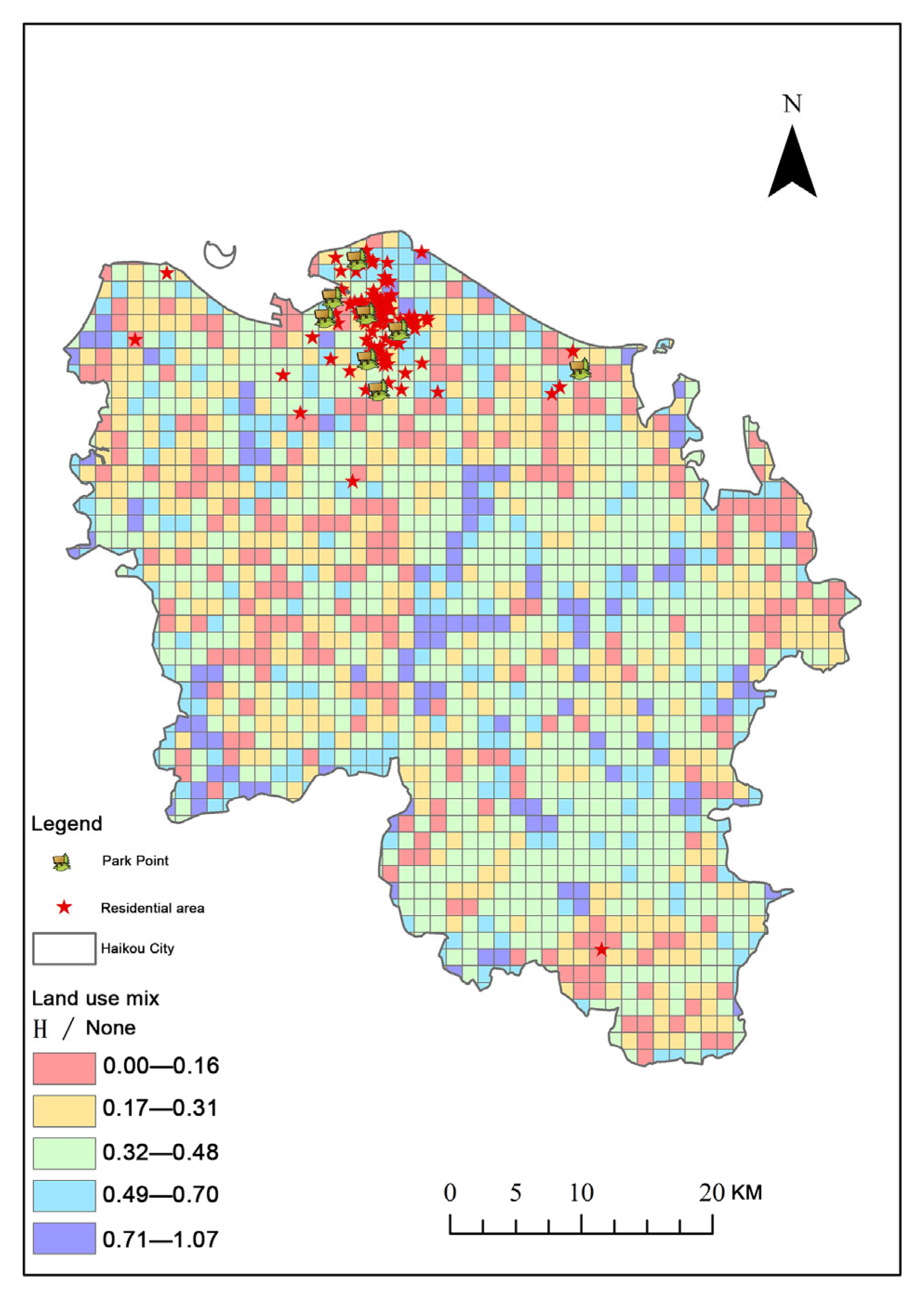
Land Use Mix Index
Definition: The land use mix index measures the diversity of land functions within a given spatial unit. A higher value indicates a more balanced and versatile urban environment.
Methodology:
Entropy Index formula was used to calculate land use diversity:
H = i = 1 n p i 1 n ( p i ) / 1 n ( n )
where p i is the proportion of land use type i within the spatial unit, and n is the total number of land use categories (e.g., residential, commercial, green space). The ArcGIS tool was applied to compute entropy for each spatial unit, revealing areas with high and low land use diversity. High entropy values suggest a mix of land uses, while low entropy values suggest more homogenous land uses.

3.2. Spatial Patterns of Public Space Indicators

In this section, we present the spatial patterns revealed by the six key indicators across the three study districts: Qilou Historic District, Chengxi Subdistrict, and Guomao Subdistrict. The analysis focuses on how each district performs in terms of spatial efficiency, accessibility, and ecological coverage, as well as the implications these spatial patterns have for the design of public spaces. The maps generated in Section 3.1 (Figure 7, Figure 8, Figure 9 and Figure 10) serve as visual representations of these spatial characteristics, and are interpreted in the context of the district’s historical, cultural, and socio-economic background. The purpose of this section is to lay the groundwork for the subsequent design interventions by identifying key areas of concern that require attention.

3.2.1. Qilou Historic District: High Functional Density, Low Green Space

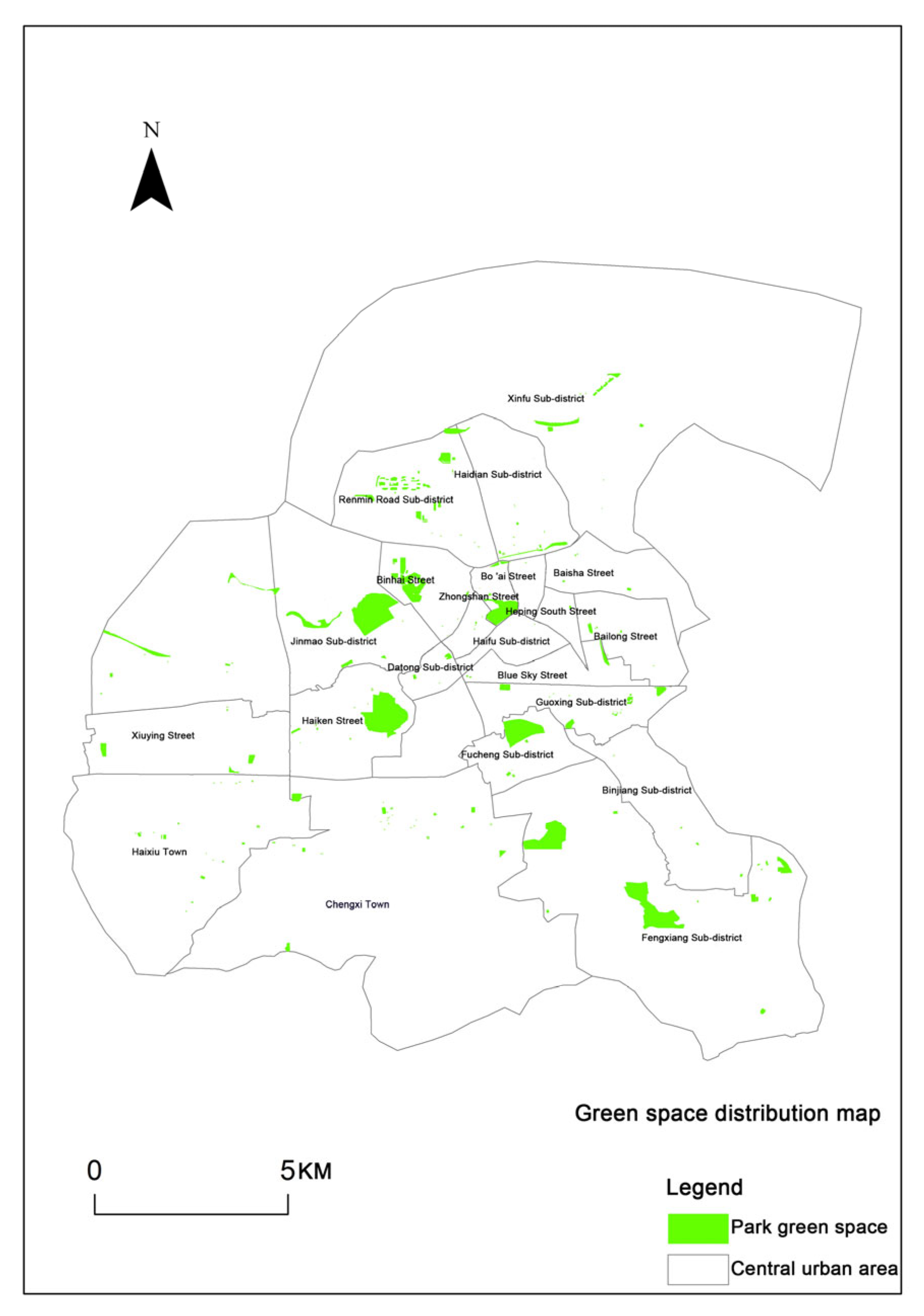
The Qilou Historic District is characterized by high functional density, reflecting a concentration of public services, commercial areas, and residential buildings. This spatial pattern is a result of the district’s historical development, where urbanization occurred over time, leading to densely packed spaces with mixed-use functionality. However, despite its high functional density, the district suffers from a significant lack of green space. Figure 7 highlights that green spaces in Qilou are concentrated in a few isolated pockets, with large areas lacking sufficient greenery. This limited access to green spaces can reduce residents’ quality of life, especially in a dense urban environment where open spaces are crucial for relaxation and recreation.
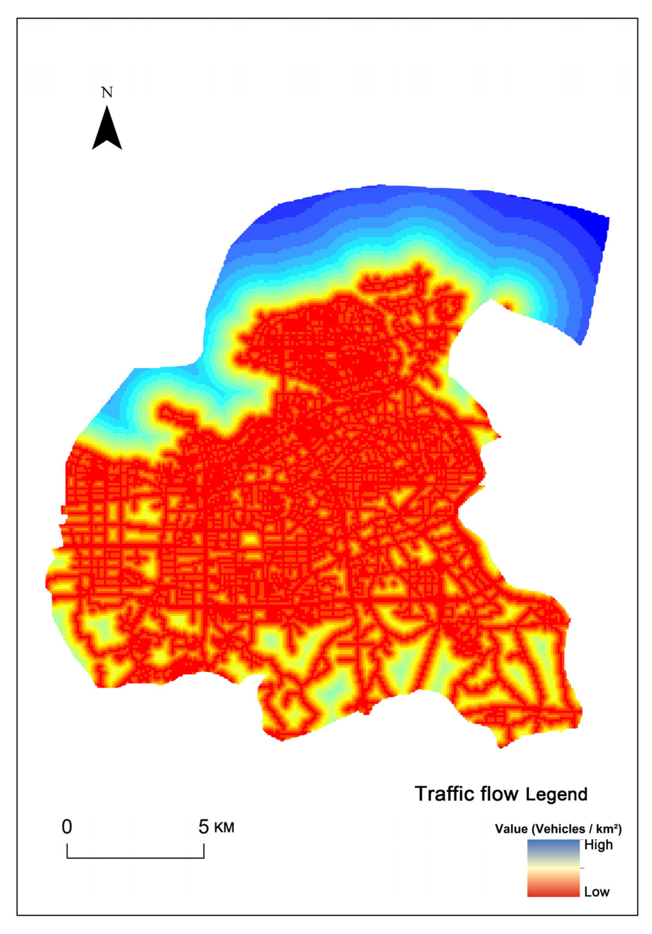
In terms of accessibility, the district shows high road network density, as evidenced by Figure 8, but the narrow street network limits pedestrian movement. Additionally, the area exhibits significant spatial fragmentation, which is a challenge for creating continuous public spaces that can serve the diverse needs of the community. Given the district’s high functional density and low green space, a modular design intervention could provide flexible solutions for increasing green spaces and improving accessibility, while preserving the historical character of the area.

3.2.2. Chengxi Subdistrict: High Fragmentation, Low Ecological Infrastructure

Chengxi Subdistrict is a transitional area that has seen rapid urban growth but lacks sufficient infrastructure. The analysis reveals that this area faces substantial spatial fragmentation, with irregular land parcels and disconnected public spaces. Figure 9 shows that public services and recreational facilities are unevenly distributed, with certain areas of the district having little access to key amenities. This issue is exacerbated by the lack of green spaces, as shown in Figure 7, where many parts of Chengxi are devoid of green areas.
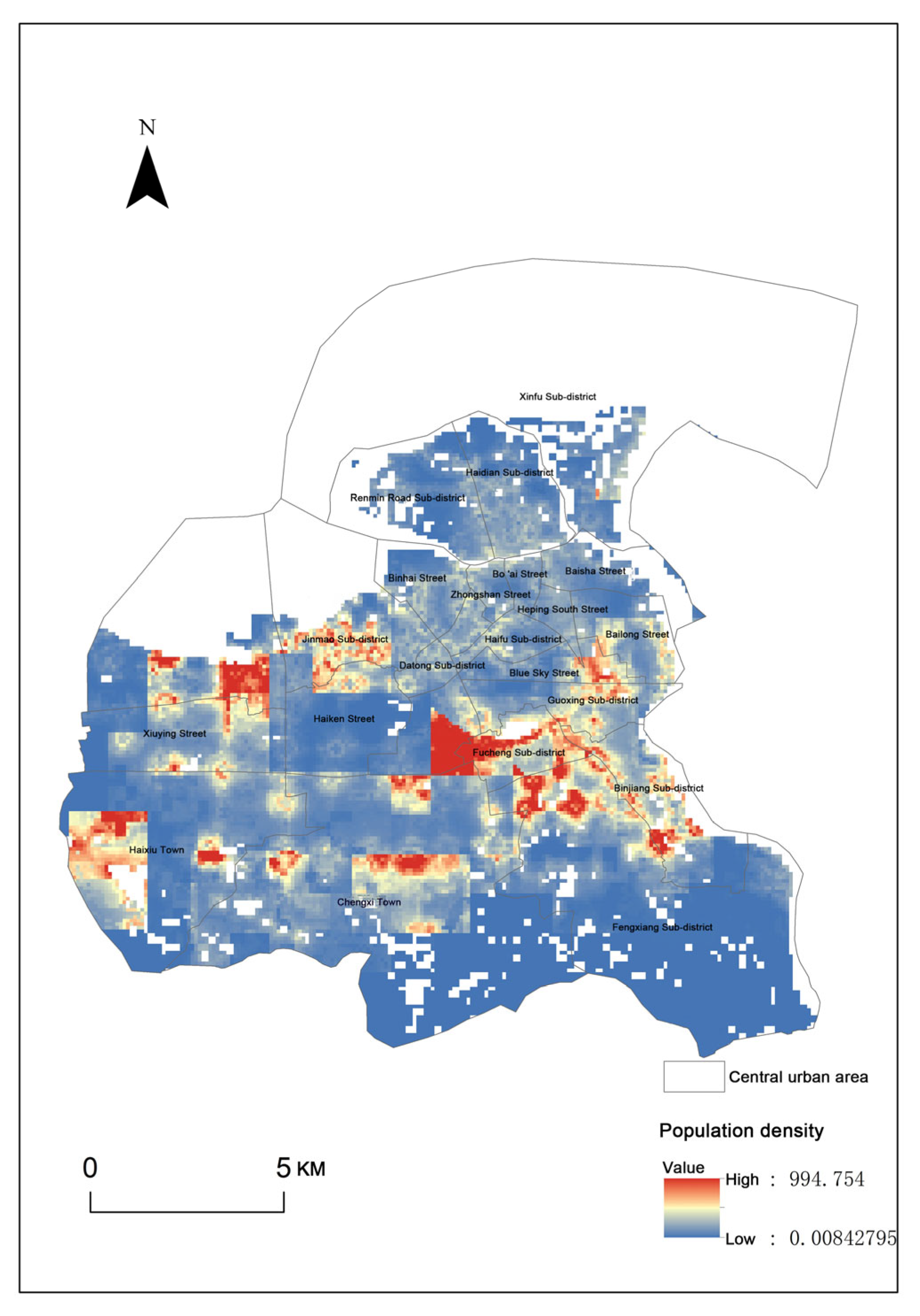
Additionally, the district has a low level of ecological infrastructure, which is critical for maintaining environmental health and improving the quality of public spaces. Figure 10 shows that the population density in Chengxi is high, but the infrastructure has not kept pace with the growing population. The lack of accessible services and green spaces, combined with poor connectivity, contributes to the lower quality of life in this area. A modular design approach in Chengxi could focus on creating compact, multifunctional spaces that address the lack of services and ecological infrastructure. By incorporating green spaces, improving pedestrian connectivity, and providing flexible public spaces, modular interventions can significantly enhance the livability of this area.

3.2.3. Guomao Subdistrict: High Accessibility, Limited Adaptability

Guomao Subdistrict, as the city’s administrative and commercial core, is characterized by large public spaces that are typically underutilized due to their rigid design. Figure 9 shows that while the area has high functional density, the spatial design is overly standardized, with large plazas and wide streets that lack the adaptability to meet diverse community needs. Figure 8 indicates that the district has excellent accessibility to road networks, but the oversized spaces are not well-suited for everyday use, especially for local residents. Additionally, Guomao suffers from a lack of community-oriented spaces, as shown by the low density of small-scale facilities and green spaces. Figure 10 reveals that while the district is not as densely populated as Chengxi, there are still significant local needs for recreational spaces and services. The rigid layout of public spaces, combined with limited diversity in land use, means that the area fails to provide a variety of spaces for different social groups. The modular design strategy for Guomao should focus on creating smaller, adaptable spaces that can better serve local residents. This could involve redesigning public squares to provide flexible areas for various activities, such as outdoor seating, cultural events, and social gatherings. Modular interventions could also integrate green elements to enhance the district’s ecological quality and improve residents’ access to natural spaces.

3.3. Key Challenges and Design Implications

Building upon the spatial and demographic analyses presented in Section 3.1 and Section 3.2, this section synthesizes the major challenges confronting community public spaces in the study area and maps them to potential modular design strategies. The aim is to ensure that design interventions are not only responsive to current deficiencies but are also grounded in evidence-based spatial diagnostics.
(1)
Spatial Inefficiency and Fragmentation
Across the Chengxi and Guomao subdistricts, the analysis reveals a prevalence of underutilized, residual spaces—particularly at the intersections of road networks and near low-density residential zones. These areas exhibit low functional density (Figure 9) and limited land use mix (Figure 11), resulting in inefficient space utilization. Modular solutions such as compact, multi-functional units (e.g., combining seating, shading, and exercise functions) are well-suited to activate these fragmented plots while minimizing land acquisition needs.
(2)
Inadequate Age-Friendly Infrastructure
Survey data (Section 2.2) and population distribution maps (Figure 10) indicate a high proportion of elderly residents, particularly in Chengxi and Qilou. However, the facility demand radar chart highlights a lack of designated elderly zones and accessible design features. To address this gap, modular design should integrate age-inclusive components such as low-impact fitness equipment, rest nodes with shade, and wheelchair-accessible pathways, which can be flexibly deployed in varied spatial settings.
(3)
Cultural Discontinuity in Historic Areas
In Qilou, while the built form preserves architectural heritage, the survey results point to low perceived safety and deteriorating environmental conditions. Many public spaces lack cultural continuity, reducing their capacity to evoke a sense of place. Here, modular interventions can incorporate local motifs, historical symbols, and participatory art elements that reflect the district’s cultural identity. This approach ensures not only physical renewal but also symbolic reactivation of collective memory.
(4)
Ecological Vulnerability and Green Deficits
Green space distribution (Figure 7) shows pronounced gaps in Chengxi and Guomao, with limited tree cover and heat-mitigating elements. Modular units with integrated planters, vertical greening, or shaded pavilions can provide microclimatic relief and improve environmental quality. Their scalability and prefabrication also allow for phased implementation in ecologically sensitive areas.
In sum, these findings underscore the necessity of a modular design strategy that is not only spatially flexible but also socially inclusive and culturally embedded. Each challenge identified in the analysis directly informs the configuration, placement, and function of the proposed modules, thereby closing the gap between spatial diagnosis and design deployment.

3.4. Cross-Variable Analysis

To gain a deeper understanding of the spatial relationships between different public space attributes and the environmental variables that influence them, a cross-variable analysis was performed. This analysis aimed to explore the interactions between various spatial features—such as population density, green space distribution, and land use mix—and their implications for the design and functionality of community public spaces. The following variables were considered for the cross-variable analysis:

3.4.1. Population Density vs. Green Space Accessibility

The interaction between population density and green space accessibility was analyzed to understand how well residents are served by existing green spaces, particularly in densely populated areas. Areas with high population density but limited green space access may experience higher demands for public space and, therefore, require a more targeted approach to green space distribution. The Population Density Map (Figure 10) and the Green Space Distribution Map (Figure 7) were used to identify areas where these two variables intersect and to prioritize those areas for potential modular design interventions that improve both access to green space and overall livability.

3.4.2. Land Use Mix vs. Architectural Space Distribution

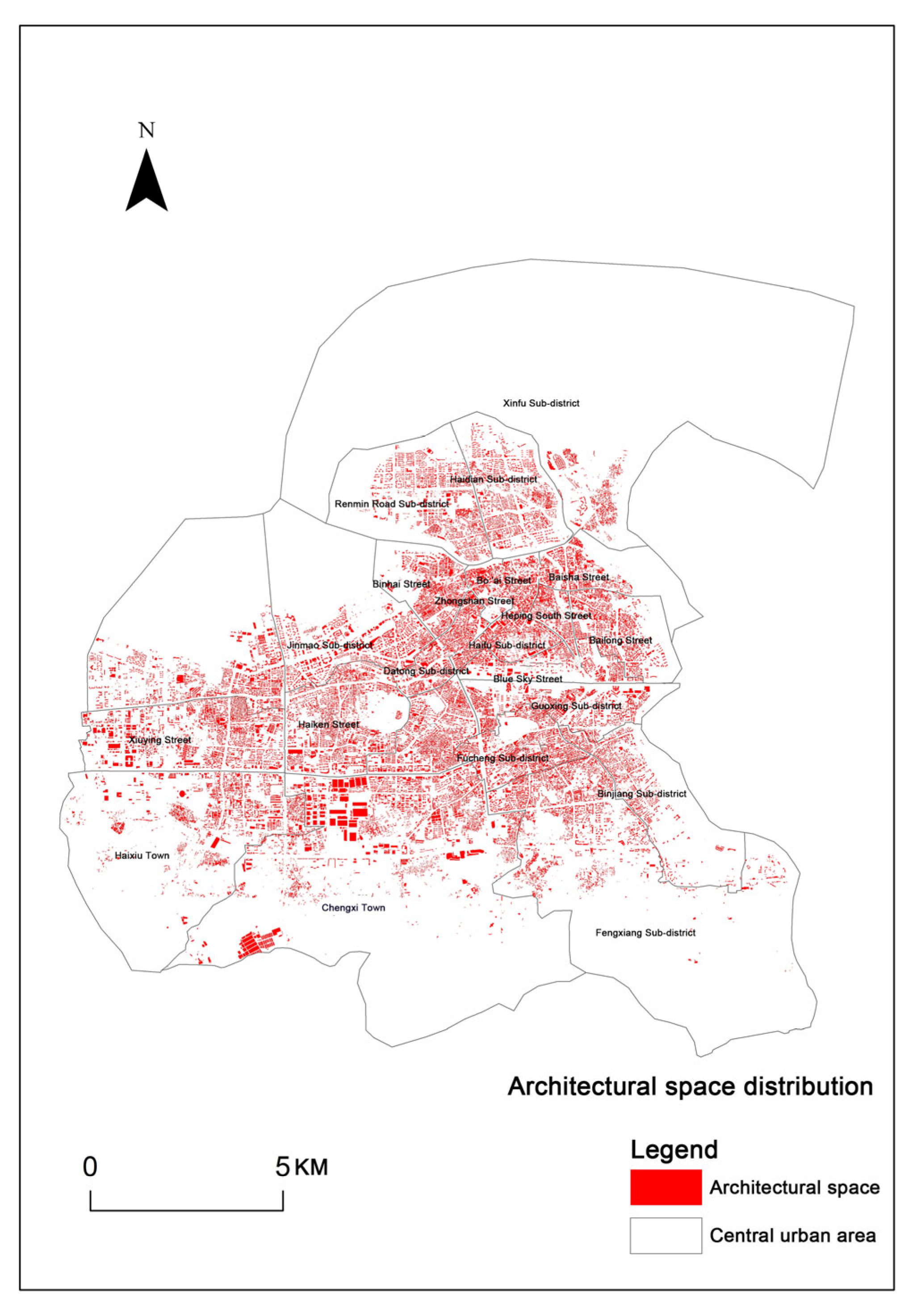
The Land Use Mix Map (Figure 11) was used to assess the degree of functional diversity in different urban areas. The analysis identified how various land uses—such as residential, commercial, and public spaces—interact within each neighborhood. High levels of land use mix were found to be associated with a higher degree of architectural space distribution, indicating more diverse and accessible public spaces. In contrast, areas with low land use mix and concentrated single-use areas were shown to have limited public space offerings, particularly in zones where residential and commercial areas are separated. The Architectural Space Distribution Map (Figure 12) was instrumental in highlighting areas where architectural density correlates with land use mix, suggesting that the design of multifunctional spaces could be more effective in these regions.

3.4.3. Functional Density vs. Traffic Flow

In examining how public spaces are utilized and accessed, the Functional Density Map (Figure 9) was analyzed alongside the Traffic Flow Map (Figure 8) to determine how transportation infrastructure influences the distribution and effectiveness of public spaces. Areas with high functional density, such as public facilities, commercial spaces, and transit hubs, often corresponded to areas with high traffic flow. This indicates that these spaces are more likely to be used and therefore may benefit from modular designs that enhance their accessibility, such as the addition of movable seating, signage, and shaded areas to accommodate high foot traffic and varying usage patterns.

3.4.4. Population Density vs. Land Use Mix

Lastly, the interaction between Population Density and Land Use Mix was explored to examine how demographic characteristics influence land use patterns. In areas with high population density but low land use mix, there is often a lack of varied public spaces to meet the needs of different demographic groups. These areas may be prioritized for mixed-use developments that integrate residential, commercial, and public spaces to create more inclusive, accessible, and socially sustainable public environments. This analysis helps to highlight areas where modular design strategies, such as flexible space usage and multifunctional infrastructures, would be most beneficial.
This cross-variable analysis provides valuable insights into the underlying patterns that shape the distribution and effectiveness of public spaces. It highlights the need for targeted interventions that consider both spatial and social factors in the design of modular public spaces. By combining demographic, environmental, and infrastructural data, the analysis supports evidence-based recommendations for the modular redesign of public spaces in Haikou’s rapidly transforming urban landscape.

4. Results

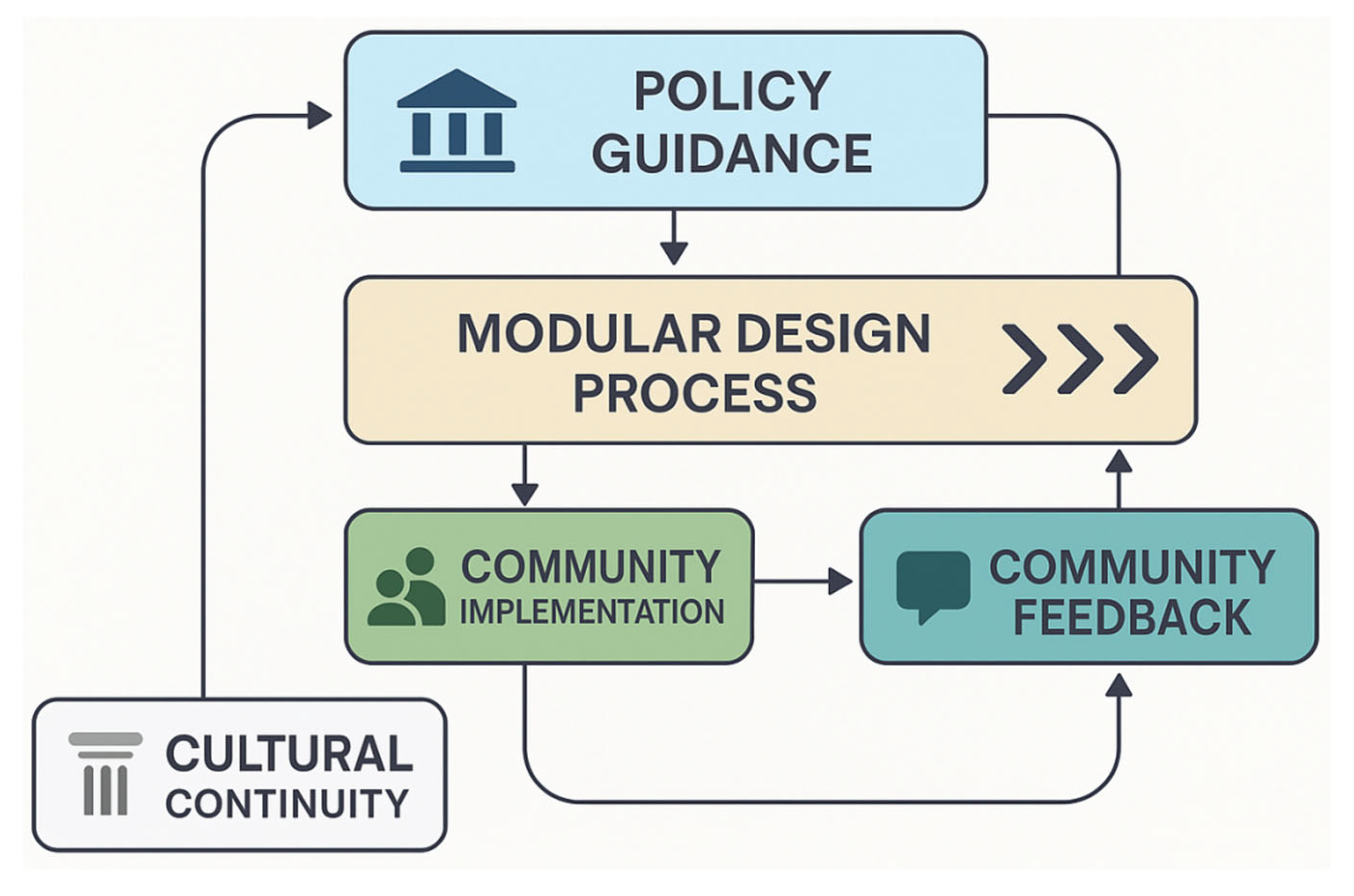
In the context of rapidly transforming urban environments, top-down policy plays a vital role in guiding spatial planning and development at the community level. The Hainan Free Trade Port Territorial Spatial Planning Regulation explicitly mandates that local plans must align with higher-level spatial frameworks, progressively refining national, provincial, and municipal visions into implementable community-level schemes. To operationalize these macro-level directives, this study introduces a “Policy–Design–Community” coupling mechanism (Figure 13), which forms a closed-loop cycle from policy formulation to modular design, community implementation, and feedback. On the one hand, this mechanism enables the transformation of abstract planning goals into concrete modular design principles—such as defining module dimensions, spatial configurations, and functional assignments—adapted to local community contexts. On the other hand, community feedback on pilot implementations allows for the iterative refinement of both design guidelines and upper-level policy objectives, establishing a dynamic feedback loop between bottom-up needs and top-down governance. Moreover, cultural continuity—as a critical dimension for shaping spatial identity and fostering emotional belonging—should be explicitly embedded within this mechanism. Doing so ensures that modular interventions not only meet functional and technical criteria but also contribute to the preservation of local cultural narratives.

4.1. Evaluation Framework for Modular Design

To ensure that the proposed modular design strategies are both evidence-based and contextually appropriate, this study established a multidimensional evaluation framework. The construction of this framework draws upon theories related to the functionality, flexibility, and sense of place of public spaces, combined with insights from survey feedback and spatial analysis [43,44]. The indicator selection process was based on three steps: (1) a review of existing modular design literature and planning standards; (2) field interviews with community stakeholders and local planning officers; and (3) triangulation with spatial diagnosis and survey data. To ensure the local relevance and practicality of the indicators, we conducted semi-structured interviews with 18 participants, including 9 local residents (stratified by age across the three districts), 6 neighborhood committee staff (from two communities per district), and 3 design professors from Hainan University specializing in modular design and public space planning. Their feedback helped validate the indicator definitions, prioritize evaluation dimensions, and refine rating thresholds. Accordingly, five core indicators were identified to assess the performance of modular design interventions in addressing spatial and social deficits. To strengthen the theoretical grounding of these five indicators, we now map each indicator to relevant literature as follows. Functional Diversity per Unit Area is supported by Liu et al. [45], who proposed a hierarchical fusion method for recognizing urban functional zones using landscape features and human activity data, and Shi et al. [46], who introduced a functional compatibility index based on spatial segregation and entropy metrics. Flexibility of Modular Combinations builds on Huang Meng [47], who developed an AHP-TOPSIS evaluation framework addressing modular adaptability in timber school projects, and Rudy Leskova [48], who defined five flexibility dimensions in modular manufacturing systems. Construction Time Reduction Rate is informed by Fahlevi et al. [49], Sievers et al. [50], and Morales [51], all of whom demonstrated how modular construction shortens project duration through prefabrication and process optimization. Improvement Rate of Resident Satisfaction references Lee et al. [52], who proposed a post-occupancy evaluation method for modular housing, and Anderson et al. [53], who integrated satisfaction metrics into continuous service improvement models. Ecological Improvement Index relies on Martinez Labib [54], Yang et al. [55], and Zhu et al. [56], who applied NDVI to assess ecological change and link vegetation structure with spatial interventions. These indicators are categorized into two types: quantitative (construction time reduction, spatial diversity) and qualitative (flexibility, user satisfaction), enabling a holistic assessment of both physical and perceptual outcomes. Importantly, these indicators are not isolated; rather, they interact conceptually—for example, increasing functional diversity can improve perceived satisfaction, while greater flexibility may shorten construction timelines. Here, Table 1 summarizes the five key evaluation indicators, detailing their calculation logic, rating dimensions, and illustrative cases. This not only enhances the transparency and replicability of the framework but also provides practical references for evaluating modular public space interventions.
To address the subjectivity of “High/Medium/Low” ratings in Table 1, we established a set of quantifiable thresholds based on literature benchmarks, expert consultations, and field survey references. Specifically:
Functional Diversity per Unit Area is rated “High” when the number of functional zones per 100 m2 exceeds 3, “Medium” for 2, and “Low” for 1 or fewer, as suggested in Gehl’s study on active public spaces [43].
Flexibility of Modular Combinations is assessed through the number of reconfigurable layouts achievable by the modules. More than 3 reconfigurations without structural adjustment is rated “High”; 2 configurations is “Medium”; 1 or none is “Low”.
Construction Time Reduction Rate is calculated using the formula:
R a d u c t i o n   R a t e = T r a d i t i o n a l   T i m e M o d u l a r   T i m e T r a d i t i o n a l   T i m e × 100 %
Values above 30% are rated “High”, 15–30% as “Medium”, and below 15% as “Low”.
Improvement Rate of Resident Satisfaction is based on pre- and post-design survey scores. A score increase over 1.2 points (on a 5-point Likert scale) is considered “High”, 0.6–1.2 as “Medium”, and below 0.6 as “Low”. These thresholds ensure the replicability and consistency of the evaluation process, and allow the index system to serve as a robust tool for guiding modular design performance assessment.
In addition, an Ecological Improvement Index was introduced to reflect environmental outcomes. This indicator is assessed by changes in greening coverage, measured through normalized difference vegetation index (NDVI) values before and after intervention, where NDVI = (NIR − Red)/(NIR + Red), with NIR representing near-infrared reflectance and Red representing red band reflectance. An NDVI increase above 0.15 is rated “High,” between 0.05 and 0.15 as “Medium,” and below 0.05 as “Low.” These thresholds ensure the replicability and consistency of the evaluation process and allow the index system to serve as a robust tool for guiding modular design performance assessment.

4.2. Practical Application of the Modular Design Scheme

Based on the “Policy–Design–Community” linkage mechanism and the modular design evaluation framework, this study applies a modular spatial design strategy to a typical community area in Haikou. In addition to these institutional and evaluative foundations, the strategy also draws on theoretical perspectives such as Design for Manufacture and Assembly (DfMA) and Urban Tectonics. DfMA principles informed the design by emphasizing modular standardization, ease of prefabrication, and reduction of construction time, while Urban Tectonics provided a conceptual lens for embedding modular units into the socio-spatial and cultural fabric of Haikou. Together, these frameworks ensured that the design interventions were not only efficient and adaptable but also capable of reinforcing cultural identity within historic contexts. The practical application therefore serves not only as a feasibility test but also as a demonstration of how evidence-based modular design, informed by both theory and data, can respond to concrete spatial challenges and resident needs.
The selected case is a resident activity area located in Zhenlongfang Community (Figure 14), Bo’ai Subdistrict, Haikou. As an integral enclave within the Qilou Historic District, Zhenlongfang was selected over Guomao and Chengxi primarily for its historical and cultural significance. It preserves the most legible “temple–stage–plaza” spatial archetype and concentrated street-life traditions in Haikou, making it the most suitable locus to test our core claim that modular design can actively support cultural continuity rather than merely adapt to it. At the same time, Zhenlongfang exhibits the typical spatial deficits identified citywide—fragmented plots, low greenery, and under-programmed edges—so findings are not idiosyncratic to heritage areas alone. Practical considerations also favored this site: community willingness to participate was highest here, local managers granted access for prototyping and observation, and the fine-grained plot structure aligns well with the 2 × 2 m2 modular grid. By contrast, Guomao’s administrative–commercial plazas are large, standardized, and less culture-dependent, while Chengxi is under rolling redevelopment, limiting stable community engagement. Selecting Zhenlongfang therefore maximizes cultural relevance, analytical representativeness, and implementability within the project window. Field surveys and on-site measurements revealed several spatial issues, including inefficient land use, poor sanitation, overcrowding of electric scooters, low greening rate, and a shortage of recreational facilities. Based on the modular design evaluation framework proposed in Section 4.1, the Zhenlongfang site was assessed using five key indicators. (Table 2) The results revealed low Functional Diversity per Unit Area, with only 1.2 functional zones per 100 m2, and low Flexibility of Modular Combinations, as only one layout configuration was feasible due to spatial and structural constraints. The Construction Time Reduction Rate was estimated to be 22%, corresponding to a “Medium” level based on standardized prefabrication of fencing and seating elements. The Improvement Rate of Resident Satisfaction was assessed as “High,” since pre-design surveys showed low baseline satisfaction (average score 2.1/5) but a strong willingness for participatory transformation. The Ecological Improvement Index was rated “Low,” with NDVI values at just 0.08 prior to intervention. This five-dimensional evaluation confirms the site’s underperformance across multiple criteria, validating the need for targeted modular interventions and providing a data-driven foundation for the design strategy that follows.
These problems also align with the community survey results and spatial analysis in Section 3, where the site was found to have limited activity nodes and insufficient functional zoning. Consequently, the modular design strategy was adopted to subdivide the area into standardized zones based on actual user demands. Each zone is equipped with corresponding modular facilities to improve spatial flexibility, functional coverage, and adaptability. The following sections will demonstrate how the modular design principles were implemented across five key aspects—zoning layout, cultural integration, furniture flexibility, prefabrication, and environmental upgrades—thereby directly addressing the spatial shortcomings identified during analysis.

4.2.1. Data-Driven Zoning Strategy and Modular Flexibility

In the modular design scheme, functional zoning serves as a critical strategy for enhancing the flexibility and adaptability of public spaces. In this study, it directly responds to the spatial deficiencies identified in earlier fieldwork and spatial analysis. The investigation revealed multiple site issues, including disorganized functional distribution, underutilized space, and a lack of designated areas for specific user groups, particularly children and the elderly. To address these problems, the layout was restructured using a grid-based modular strategy, dividing the space into 2 × 2 m2 units (Figure 15). This dimension conforms to ergonomic standards and enables rapid recombination. A 2 × 2 m2 module is sufficient to accommodate essential facilities such as seating, tables, and planting units, while still allowing enough circulation space for resident movement without congestion. The grid framework also helps to define functional zones clearly at the early design stage. The adoption of standardized modular grids directly reflects the principles of Design for Manufacture and Assembly (DfMA), ensuring efficient production and assembly, while the embedding of cultural archetypes such as the “temple–stage–plaza” layout resonates with Urban Tectonics, which emphasizes the integration of cultural meaning into material and spatial systems. Based on needs assessment data, the space was subdivided into several functional areas: a central plaza, a children’s play area, a bicycle parking zone, a leisure and entertainment zone, and support facilities such as storage and restrooms. Each zone can be flexibly adapted according to community activities and evolving user demands. For instance, the children’s play area can be reconfigured into a youth leisure space by replacing play modules with seating and tables or adding sports equipment. Similarly, seating units in the elderly leisure zone can be rearranged to create temporary gathering spaces or small-scale cultural activity areas. All equipment and furnishings in each functional zone are designed with standardized modular components, allowing seamless transitions between different spatial uses. To ensure flexibility, these components are engineered for compatibility and adaptability. Benches, tables, and play equipment are designed for easy disassembly and replacement, eliminating the need for significant structural modifications and enabling the space to respond to the varied needs of different user groups over time. The zoning logic was informed by GIS-based overlay analyses. Heatmaps of population density and spatial usage intensity highlighted the central plaza as the most active area, making it the core focus of intervention. Survey results also indicated that residents were most dissatisfied with the lack of children’s activity areas and elderly seating. In direct response, the southwest corner of the plaza—close to the entrance and offering natural shade—was designated as the children’s play zone, while adjacent quieter areas were allocated for elderly leisure. These spatial allocations were guided by the overlay of community feedback and environmental parameters such as shading, circulation paths, and noise levels. Each functional zone was equipped with modular elements designed for transformation. For example, children’s play modules can be repurposed for informal markets or performance spaces during festivals, while elderly seating modules can be rearranged into circular layouts to support social interaction. All furniture—including benches, chairs, and storage units—follows standardized dimensions, supporting efficient space management and reuse. This grid-based, data-informed approach ensures that the spatial layout is not only modular in structure but also grounded in the real needs of residents, as revealed through both quantitative and qualitative research.

4.2.2. Cultural Integration into Modular Spatial Design

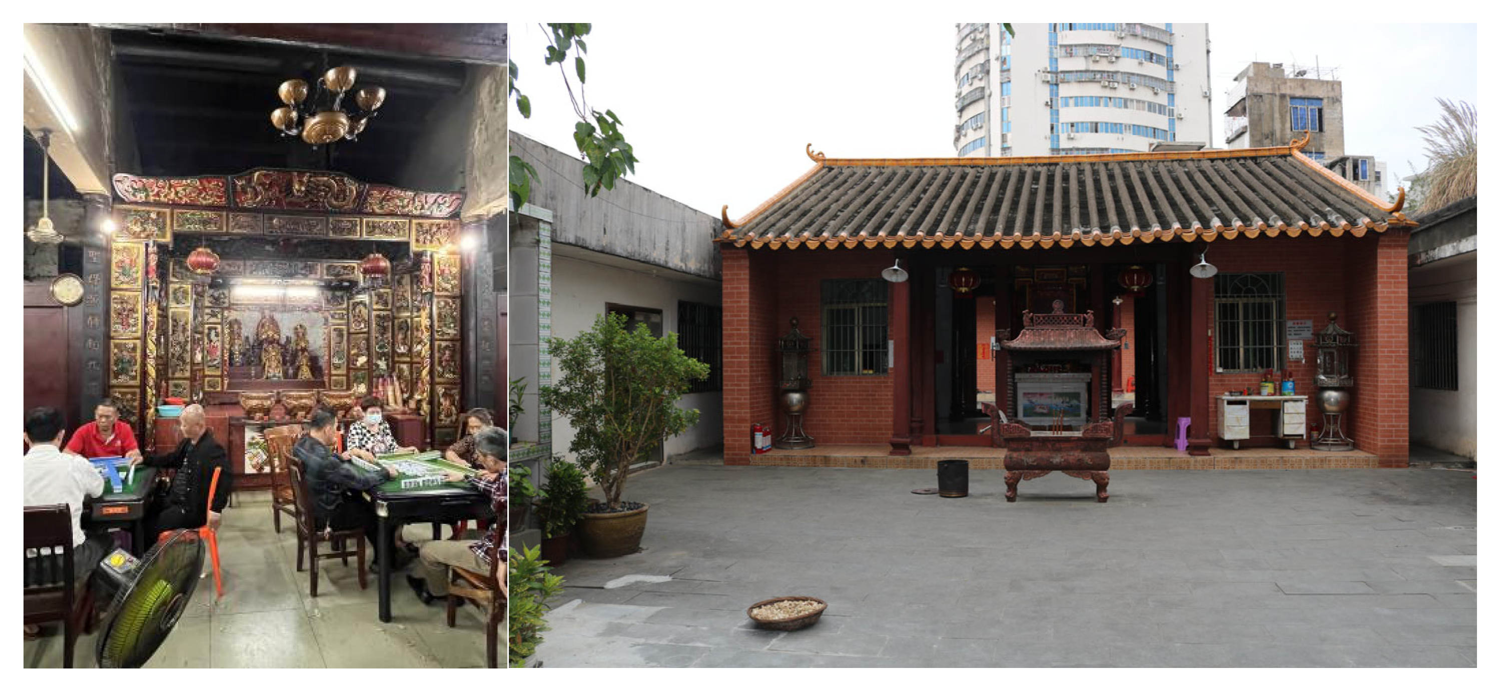
Hainan’s tropical climate and distinct regional identity have given rise to unique cultural traditions and spatial patterns, particularly evident in older neighborhoods where daily activities often occur in semi-open communal spaces. One prominent spatial structure is the “temple + stage + plaza” configuration (Figure 16), commonly found in Haikou’s traditional communities. While modular design systems are typically associated with standardization and repeatability, this project demonstrates how they can also actively preserve, reinterpret, and support local cultural practices. Rather than passively adapting to the existing cultural environment, the modular approach in this study was developed to strengthen and celebrate spatial traditions. In the Zhenlongfang Community, the design preserves the symbolic core of ancestral worship by maintaining the central axis that visually connects the temple, performance space, and public gathering areas. The modular layout does not impose rigid structures but instead provides a flexible framework that allows ritual and festive activities to take place in accordance with local traditions. For example, modules in the central plaza can be temporarily reconfigured into performance spaces or ritual seating arrangements during cultural festivals, while reverting to recreational or resting zones at other times. To address the possible tension between standardization and cultural authenticity, the design employs culturally resonant materials and spatial typologies. Modular components are not purely generic; instead, they incorporate decorative elements such as Hainanese wood carvings and traditional motifs drawn from local crafts. Additionally, modules are arranged to respect the spatial hierarchy and flow customary in ancestral temple spaces, reinforcing cultural legibility while enhancing usability. Thus, this strategy demonstrates that modular design, when carefully contextualized, can serve not only as a tool for spatial optimization but also as a medium for cultural continuity and community expression.

4.2.3. Data-Guided Modular Furniture for Flexible Spatial Use

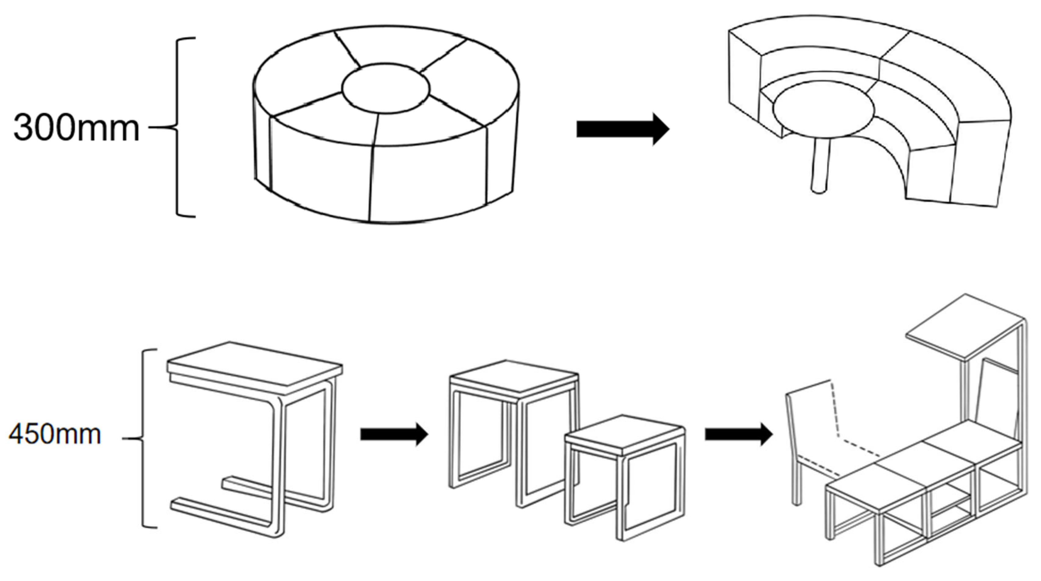
Modular furniture plays a central role in achieving spatial adaptability and efficient use of public space, and in this project, it serves as a key bridge between the evaluation framework and the design implementation. According to the assessment results of Zhenlongfang Community, a major issue was the lack of usable and flexible seating, storage, and recreational components—especially for elderly residents and families with children. In response, a system of modular furniture was developed based on a standardized 1 × 150 mm unit, allowing different configurations through simple stacking, combining, or removal. For example, planters with heights of 600 mm (3 × 150 mm), seats of 450 mm, and sofas of 300 mm provide a consistent vocabulary for space organization and user comfort (Figure 17). This system not only improves the construction efficiency but also directly enhances the “Flexibility of Modular Combinations” and “Resident Satisfaction Rate,” as defined in the evaluation metrics (Table 1). Unlike conventional fixed installations, the proposed modular furniture can be quickly reassembled to suit changing usage scenarios. A resting bench for the elderly can be expanded into a circular discussion area; a set of rectangular tables can be aligned into a temporary children’s workshop. These dynamic transformations were designed with reference to survey data, which showed a strong demand for multipurpose facilities that support both routine leisure and seasonal events. Moreover, the materials used for the modular units were selected for durability, safety, and tropical weather resistance, addressing concerns raised during field observations. Each modular element is lightweight, easy to transport, and replaceable without specialized tools, ensuring long-term maintainability and community-led management. Thus, this modular furniture system is not merely a decorative or auxiliary component but a functional infrastructure solution tailored to specific demographic needs and spatial constraints. It reflects a direct translation of data into design, making public space truly responsive to user behaviors and community dynamics.

4.2.4. Climate-Responsive Prefabrication for Efficient Implementation

In order to enhance construction efficiency and climatic resilience in Haikou’s tropical environment, the modular design incorporates prefabricated systems for shading, structural framing, and functional enclosures. Field observations identified that existing canopies and facilities in the Zhenlongfang Community were often outdated, visually unappealing, and difficult to disassemble or maintain. To resolve these issues, the design adopts prefabricated lightweight steel frames, precast concrete wall panels, and detachable roof modules, which reduce on-site construction time and offer improved wind and corrosion resistance. These prefabricated solutions directly contribute to the “Construction Time Reduction Rate” metric in the modular evaluation system (Table 1), enabling rapid deployment while meeting durability standards required by tropical weather conditions. Beyond technical efficiency, these components are customized with culturally relevant surface treatments and material textures, incorporating local patterns such as Hainanese wood carvings and folk art motifs. This approach ensures that modularity and prefabrication do not compromise cultural authenticity, but instead provide a new platform for cultural expression. For instance, shading devices are designed not only to block sunlight but also to integrate symbolic imagery drawn from the community’s ancestral heritage, reinforcing spatial identity and community recognition. Such designs were guided by feedback from resident interviews and cultural heritage experts, aligning functional performance with emotional resonance.
Moreover, the standardized nature of the prefabricated elements allows for modular expansion or replacement without damaging the original structure. If a certain area becomes more frequently used—such as a resting area gaining popularity among the elderly—additional prefabricated benches and canopy elements can be installed with minimal disturbance. This adaptability addresses the concern of long-term sustainability and ensures that the modular strategy remains open-ended and responsive over time. By integrating cultural expression, climatic adaptation, and construction efficiency, the prefabrication strategy enhances the practical operability and contextual relevance of the modular public space design.

4.2.5. Environmental Upgrades for Greening, Sanitation, and Safety

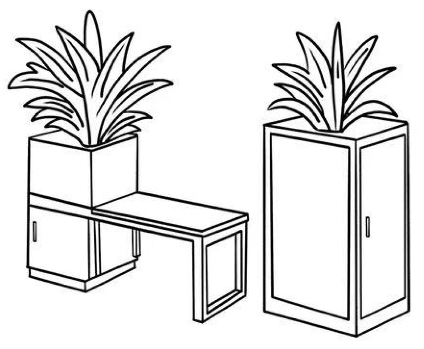
Environmental quality is a critical concern repeatedly emphasized by residents during the community survey, especially regarding insufficient greenery, poor waste management, and safety risks from unregulated traffic. To address these pain points, the modular design integrates a set of targeted environmental enhancements that are both flexible and scalable, aligning with the performance indicators outlined in the evaluation framework. For greening improvement, modular turf mats, movable planter walls, and vertical planting systems are installed in zones with low vegetation coverage (Figure 18). These elements adopt the same 2 × 2 m2 base module, allowing easy reconfiguration and maintenance. Plant species were selected based on Haikou’s tropical climate, prioritizing drought resistance, shade provision, and low maintenance. In particular, shaded seating modules were combined with tall shrubs or trees to provide thermal comfort while enhancing spatial aesthetics.
In terms of sanitation, standardized modular waste sorting stations and cleaning cabinets were installed in each functional area. The modular nature of these units facilitates relocation, expansion, or reorganization according to usage intensity. Additionally, community feedback revealed strong dissatisfaction with hygiene in areas of high pedestrian flow, such as entrances and leisure zones. These nodes were prioritized for sanitation interventions, with increased bin density and informational signage to promote proper waste disposal behaviors.
Regarding safety, GIS-based spatial mapping indicated several “blind spots” with poor lighting and no surveillance. These areas—mostly adjacent to peripheral green patches and informal scooter parking zones—were upgraded with solar-powered smart lighting poles and CCTV (Closed-Circuit Television, used for real-time monitoring and crime prevention in public spaces) modules, which follow the standard modular unit size and can be installed without complex wiring. Scooter parking was also standardized into designated modular parking zones with clear demarcation, thereby reducing circulation conflicts and improving spatial legibility.
All environmental upgrades were informed by cross-analysis of spatial and survey data, ensuring that interventions directly target resident priorities. Moreover, these upgrades are not fixed but allow future scaling or replacement as needs evolve. By improving ecological quality, sanitation, and safety through modular interventions, the project enhances both perceived and actual usability of the public space, contributing significantly to the “Resident Satisfaction Improvement Rate” and creating a cleaner, safer, and more livable community environment.

5. Discussion

Building upon the modular design strategies implemented in the selected site, this section further explores the theoretical implications, practical effectiveness, and limitations of the proposed approach. By critically reflecting on how the modular interventions address spatial and cultural challenges, and how they integrate policy objectives, design logics, and community needs, the discussion aims to position the research within broader discourses of sustainable urban design. The following subsections elaborate on the design’s responsiveness, policy integration, evaluation challenges, and research contributions.

5.1. Responsiveness of Modular Strategies to Spatial and Cultural Challenges

This study demonstrates how modular strategies respond to both spatial and cultural challenges identified in the earlier phases of field investigation and GIS-based analysis. The five modular design interventions proposed—functional zoning, cultural integration, modular furniture, prefabricated elements, and environmental upgrades—each target specific deficiencies observed in Zhenlongfang Community. For example, the application of modular zoning directly addresses inefficient land use and spatial fragmentation by introducing standardized 2 × 2 m2 units that facilitate clear functional division and reconfiguration. This approach ensures efficient spatial utilization and supports dynamic adaptation to resident needs. Cultural integration strategies respond to the need for preserving traditional community structures, particularly the “temple–stage–plaza” layout. By embedding modular units within culturally significant spatial patterns, the design balances technical efficiency with cultural continuity. Modular furniture addresses the lack of flexibility and multifunctionality in existing public spaces. Standardized units can be assembled or reconfigured to suit different age groups and activity types, promoting inclusive use across diverse user groups. The use of prefabricated components improves construction efficiency and safety, which is especially important in Haikou’s tropical climate, while enabling rapid installation and cost control. Finally, the addition of modular greening elements and sanitation infrastructure enhances environmental quality and responds to community concerns regarding hygiene and greenery coverage. Together, these strategies form a cohesive system that not only addresses current deficiencies but also enhances the resilience and adaptability of public spaces in rapidly transforming urban environments.

5.2. Enhancing the Policy–Design–Community Feedback Loop

The proposed “Policy–Design–Community” framework highlights the importance of transforming top-down planning objectives into actionable community-level design strategies, while also integrating bottom-up feedback into policy refinement. In the case of Zhenlongfang, this feedback loop was implemented through participatory workshops and informal interviews conducted with local residents, property managers, and subdistrict officials. These engagements not only revealed spatial usage patterns—such as residents’ preference for shaded gathering spaces and their dissatisfaction with sanitation—but also directly influenced the prioritization of design interventions. For instance, the modular children’s play area and elderly activity zone were both positioned in response to resident-identified needs and site-specific environmental conditions, such as shade coverage and noise exposure. Furthermore, the results of these participatory sessions were summarized into a short report submitted to the Bo’ai Subdistrict Planning Office, thereby enabling the upward transmission of community preferences. In response, the subdistrict provided policy support and minor funding assistance to pilot the modular interventions on-site. This bidirectional flow—from planning intent to local design, and from community feedback back to policy refinement—demonstrates the viability of a dynamic policy–design–community cycle. It ensures that modular design is not only responsive to spatial and cultural issues but is also embedded within an iterative governance structure capable of sustaining long-term community improvements.

5.3. Limitations and Prospects

While the modular design strategy proposed in this study demonstrates significant potential in addressing spatial inefficiencies and promoting cultural continuity, several limitations remain. First, the design proposals have not yet undergone long-term implementation or systematic post-occupancy evaluation. Although the spatial logic and community feedback support the feasibility of the scheme, the actual effectiveness of modular interventions—particularly in terms of durability, user adaptability, and behavioral change—remains to be empirically validated. Future research may incorporate mid-term evaluation tools such as resident activity logs, automated environmental sensors, or temporal usage mapping to assess the evolving impact of the design in a dynamic real-world context [57,58]. Second, the level of community participation during the design phase, while meaningful, was constrained by time, language, and demographic accessibility. Elderly residents, for instance, often lacked familiarity with participatory processes or digital platforms. To enhance inclusiveness, future projects should adopt more diverse and culturally sensitive engagement tools, such as visual voting boards, tactile models, or intergenerational storytelling sessions [59]. Third, policy integration remains uneven across administrative levels. Although the Bo’ai Subdistrict supported the pilot implementation, broader institutional alignment with city-level planning departments was limited, highlighting the need for a more scalable governance interface that formalizes feedback loops between community, design, and policy. Fourth, environmental and ecological indicators—such as stormwater management, biodiversity, and material life-cycle—were not fully addressed in the current framework due to data limitations. Although this study introduced an Ecological Improvement Index based on NDVI change, long-term ecological monitoring data (e.g., vegetation indices across multiple years, microclimate regulation, biodiversity counts) are still absent, which prevents a more comprehensive assessment of ecological outcomes. Future research should systematically integrate such metrics to quantify environmental performance and resilience, especially in tropical contexts where climate pressures are acute. Finally, the long-term viability of modular interventions also requires further study. Maintenance costs, durability of prefabricated components under tropical conditions, and the establishment of community stewardship models will be critical in determining whether modular strategies remain effective over time. Addressing these practical considerations is essential to ensuring that the interventions not only deliver short-term improvements but also sustain community benefits in the long run.

5.4. Comparative Reflections and Theoretical Contribution

Compared with existing studies on community public space design in rapidly urbanizing cities, this research presents a unique integration of spatial analysis, participatory feedback, and modular design logic. While much of the literature has focused either on top-down planning efficiency or on community aesthetics and cultural narratives [60,61,62], this study positions modularity as both a technical and sociocultural strategy. It demonstrates how evidence-based spatial data—such as population density, land use mix, and accessibility—can be directly translated into flexible modular components that respond to local demands. Methodologically, the research differs from prior modular design frameworks that often emphasize construction logistics or aesthetic form. Instead, it proposes a four-dimensional evaluation model that integrates functionality, flexibility, construction efficiency, and user satisfaction. This model not only enhances operational feasibility but also provides a basis for iterative assessment, thereby bridging the gap between quantitative spatial analysis and qualitative human-centered design. Theoretically, the study contributes to the growing discourse on adaptive urbanism by introducing a “Policy–Design–Community” feedback loop [63,64]. This mechanism helps contextualize design decisions within broader policy frameworks while grounding them in site-specific social feedback. The linkage between modular interventions and cultural continuity—particularly in relation to ancestral temples and communal rituals—offers a nuanced perspective on how modular systems can go beyond technical convenience to actively preserve collective identity. Furthermore, the research advances the operationalization of modular design in the Chinese context [65,66], where rapid urban expansion often outpaces bottom-up design experimentation. By applying standardized modules to retrofit existing urban spaces, the study demonstrates how modularity can act as a transitional tool between large-scale policy intentions and small-scale community actions. Future theoretical work may expand upon this approach by exploring its adaptability across different socio-political systems, climate zones, and cultural landscapes. Nonetheless, the integration of spatial data, community needs, and modular responses in this study provides a replicable model for sustainable and culturally rooted public space renewal. In subsequent studies, integrating advanced machine learning techniques into modular public space design could significantly enhance analytical capacity. Recent research has introduced frameworks that combine later temporal attention and singular pooling to improve spatiotemporal pattern recognition [67]. Although these mechanisms are not yet applied in this study, they offer valuable potential for refining the MDIPINET (Modular Design–Public Input–Environmental Network) framework. For example, later temporal attention could help model dynamic shifts in community spatial preferences, while singular pooling may support the aggregation of multidimensional environmental and behavioral datasets. Incorporating these approaches would enable modular strategies to be more predictive, adaptive, and attuned to evolving user needs.

6. Conclusions

This study proposed a modular design strategy for community public spaces in rapidly transforming urban environments, guided by a “Policy–Design–Community” linkage mechanism. Through the integration of spatial data analysis, community feedback, and modular principles, the research developed an evaluation framework that balances functionality, flexibility, construction efficiency, and resident satisfaction. The practical application in Haikou’s Zhenlongfang Community demonstrated how evidence-based modular strategies can effectively respond to challenges such as inefficient spatial layout, limited activity zones, and insufficient cultural continuity. While the methodology and findings offer a transferable framework for other urban communities, the study also acknowledges its limitations. Due to the absence of long-term post-implementation data, only short- to mid-term predictions could be made. Nonetheless, the approach is replicable in different urban settings, particularly in regions undergoing rapid policy-driven redevelopment. Future studies may adopt midterm evaluation tools such as resident diaries, participatory observations, or environmental sensors to assess the dynamic performance of modular interventions over time. In the context of cultural tourism, this study highlights the dual role of local residents as both beneficiaries and participants [68]. Activating public spaces through culturally rooted modular design not only supports tourism development but also reinforces residents’ identity and sense of belonging [69,70]. Furthermore, the integration of modular strategies with geographic spatial analysis strengthens the precision of spatial planning and resource allocation. Future research may explore the incorporation of adaptive learning mechanisms, such as later temporal attention and singular pooling, to enhance the real-time adaptability of modular planning systems.

Author Contributions

Conceptualization, W.S.; methodology, W.S.; software, W.S.; validation, W.S.; formal analysis, W.S.; investigation, W.S.; resources, W.S.; data curation, W.S.; writing—original draft preparation, W.S.; writing—review and editing, W.S. and D.C.; visualization, W.S.; supervision, W.X.; project administration, W.X.; Literature collection and review, D.C. All authors have read and agreed to the published version of the manuscript.

Funding

This research received no external funding. The APC was funded by the authors.

Institutional Review Board Statement

Ethical review and approval were waived for this study due to the fact that the survey collected only anonymized, non-sensitive data related to residents’ perceptions of community public spaces, and did not involve any medical or health-related information.

Informed Consent Statement

Informed consent was obtained from all subjects involved in the study.

Data Availability Statement

The data presented in this study are available on request from the corresponding author.

Conflicts of Interest

The authors declare no conflict of interest.

References

  1. Charalambous, N.; Knierbein, S. Mapping Urban Injustices in Public Space: Challenges and Opportunities. J. Public Space 2023, 8, 1–6. [Google Scholar] [CrossRef]
  2. Bravo, L. Public space and the New Urban Agenda. In Companion to Public Space; Routledge: London, UK, 2020. [Google Scholar] [CrossRef]
  3. Yuan, P.; Yan, C. Community Meta-Box: A Deployable Micro Space for New Publicness in High-Density City. She Ji J. Des. Econ. Innov. 2023, 9, 58–75. [Google Scholar] [CrossRef]
  4. Fang, N. Research on the Exploration of Micro-Space under Urban Renewal—Take Paley Park in the United States as an Example. Learn. Educ. 2020, 9, 76. [Google Scholar] [CrossRef]
  5. Mela, A. Urban public space between fragmentation, control and conflict. City Territ. Archit. 2014, 1, 15. [Google Scholar] [CrossRef]
  6. Sas-Bojarska, A.; Rembeza, M. Public spaces connecting cities. Green and Blue Infrastructures potential. In Proceedings of the International Conference: Green and Blue Infrastructures, Virtual, Cultural and Social Networks, Naples, Italy, 18–19 December 2015; pp. 15–16. [Google Scholar]
  7. Hu, Y.; Song, W. Urban Space Privatization fragmentation Trend under the Background of Social Spatial Reconstruction. Urban Stud. 2011, 18, 6. [Google Scholar]
  8. Chen, S. Construction of Public Space in Urban Community. J. Sichuan Univ. Sci. Eng. 2009, 24, 5. [Google Scholar]
  9. Yao, Y.; Ding, J.; Ling, N. New Urbanism: A Design Strategy for Creating High-Quality Urban Public Space. J. Zhejiang Sci-Tech Univ. 2012, 29, 61–65. [Google Scholar]
  10. Altieri, M.; Rojas, R. Urban Fragmentation and Discontinuity: Paranhos Case Study. Civ. Eng. Archit. 2016, 4, 175–182. [Google Scholar] [CrossRef]
  11. Bohatyrets, V.; Melnychuk, L. Cultural Memory and Urban Space in Shaping Cultural Identity. Hist. Political Probl. Mod. World 2019, 40, 160–183. [Google Scholar] [CrossRef]
  12. Yanmaz, K.; Cengiz, A. Preserving the spatial memory in historic buildings and spaces and its contribution to the urban identity: A case study of çanakkale urban site. J. Sci. Perspectives. 2019, 3, 329–354. [Google Scholar] [CrossRef]
  13. Bikomeye, J.; Namin, S.; Anyanwu, C.; Rublee, C.; Ferschinger, J.; Leinbach, K.; Lindquist, P.; Hoppe, A.; Hoffman, L.; Hegarty, J.; et al. Resilience and Equity in a Time of Crises: Investing in Public Urban Greenspace Is Now More Essential Than Ever in the US and Beyond. Int. J. Environ. Res. Public Health 2021, 18, 8420. [Google Scholar] [CrossRef]
  14. Ge, Y.; Kang, X. Research on healthy urban resilience public space planning. In Proceedings of the 56th ISOCARP World Planning Congress, Virtual, 8–12 November 2020. [Google Scholar] [CrossRef]
  15. Blaschke, P.; Zari, P.; Chapman, R.; Randal, E.; Perry, M.; Howden-Chapman, P.; Gyde, E. Multiple Roles of Green Space in the Resilience, Sustainability and Equity of Aotearoa New Zealand’s Cities. Land 2024, 13, 1022. [Google Scholar] [CrossRef]
  16. Kurniawati, W. Urban Equity in Public Space A Comparison Research between Traditional and Modern Public Space in Indonesia. Ph.D. Thesis, Technische Universiteit Darmstadt, Darmstadt, Germany, 2018. [Google Scholar]
  17. Shao, Y.; Ma, J.; Zavala, V.M. A spatial superstructure approach to the optimal design of modular processes and supply chains. Comput. Chem. Eng. 2022, 170, 108102. [Google Scholar] [CrossRef]
  18. Yua, M. The Methodology of Digital Modular Fabrication Based on the BIM Platform. Time Archit. 2013, 2, 30–37. (In Chinese) [Google Scholar]
  19. Zhong, X.; Yang, Y. Parametric System of Panel Furniture Based on Modular Design. For. Mach. Woodwork. Equip. 2009, 37, 3. [Google Scholar]
  20. Chen, L.; Jiao, R.; Liao, J. Application of Modular Design in the Intelligent Building Product Designing. Appl. Mech. Mater. 2012, 214, 654–658. [Google Scholar] [CrossRef]
  21. Wu, H. Research on Application of Modular in Construction of Expressway Operation Management Standards System. China Stand. 2014, 6, 4. [Google Scholar]
  22. Ghannad, P.; Lee, Y. Automated modular housing design using a module configuration algorithm and a coupled generative adversarial network (CoGAN). Autom. Constr. 2022, 139, 104234. [Google Scholar] [CrossRef]
  23. Lukyanchenko, S.O.; Babyak, V.I.; Gnes, I.P. Experience in using modular social housing. Arch. Stud. 2020, 2020, 194–197. [Google Scholar] [CrossRef]
  24. Wallance, D. The Future of Modular Architecture; Taylor & Francis: London, UK, 2021. [Google Scholar] [CrossRef]
  25. Coskun, C.; Lee, J.; Xiao, J.; Graff, G.; Kang, K.; Besiktepe, D. Opportunities and Challenges in the Implementation of Modular Construction Methods for Urban Revitalization. Sustainability 2024, 16, 7242. [Google Scholar] [CrossRef]
  26. Muldoon-Smith, K.; McGuinness, D. Modular solutions: Disaster, hiatus and opportunity in the ‘meanwhile’ city. In Proceedings of the RGS-IBG Annual International Conference 2018, Cardiff, UK, 28–31 August 2018. [Google Scholar]
  27. Sádaba, J.; Alonso, Y.; Latasa, I.; Luzarraga, A. Towards Resilient and Inclusive Cities: A Framework for Sustainable Street-Level Urban Design. Urban Sci. 2024, 8, 264. [Google Scholar] [CrossRef]
  28. Liu, M.; Sun, Z.; Guo, X.; Chen, X.; Liu, Z. An Investigation into the Key Factors to Improve the Attractiveness of Modular Furniture in the Living Environment of China’s Metropolitan Migrants. In Proceedings of the HCI International 2017—Posters’ Extended Abstracts 19th International Conference, HCI International 2017, Vancouver, BC, Canada, 9–14 July 2017; pp. 575–582. [Google Scholar] [CrossRef]
  29. Philip, E. Coupling Sustainable Development Goal 11.3.1 with current planning tools: City of Hamilton, Canada. Hydrol. Sci. J. 2021, 66, 1124–1131. [Google Scholar] [CrossRef]
  30. Lee, J.; Kim, J.; Lee, H.; Lee, Y.; Kim, H. Small-Scale Public Rental Housing Development Using Modular Construction—Lessons learned from Case Studies in Seoul, Korea. Sustainability 2019, 11, 1120. [Google Scholar] [CrossRef]
  31. Munmulla, T.; Hidallana-Gamage, H.D.; Navaratnam, S.; Ponnampalam, T.; Zhang, G.; Jayasinghe, T. Suitability of Modular Technology for House Construction in Sri Lanka: A Survey and a Case Study. Buildings 2023, 13, 2592. [Google Scholar] [CrossRef]
  32. Parmar, D. Hands Together. J. Public Space 2024, 9, 185–198. [Google Scholar] [CrossRef]
  33. Su, P. Participatory Communication Referred to Meta-Design Approach through the FleXpeaker™ Application of Innovative Material in Exhibition Design. Adv. Technol. Innov. 2016, 1, 21–24. [Google Scholar]
  34. Afonso, F.; Lu, J. Post-disaster Temporary Housing System based on Generative Design Method. Int. J. Struct. Civ. Eng. Res. 2021, 10, 80–84. [Google Scholar] [CrossRef]
  35. Cao, Y.; Ma, P. Modular New Residential Design under the Background of Rural Revitalization in Southern Anhui—A Case Study of Liqiao Villagers’ Residence in Yi’an District, Tongling City. J. Civ. Eng. Urban Plan. 2023, 5, 30–39. [Google Scholar] [CrossRef]
  36. Miao-Mia, Z. Deduction of the architectural design to the current cultural information. Shanxi Architecture. 2008, 29, 29–30. (In Chinese) [Google Scholar]
  37. Dike, A.; Smith, M. On Sociocultural Continuity. Curr. Anthr. 1982, 23, 585–586. [Google Scholar] [CrossRef]
  38. Cobb, C.; Schwartz, S.; Martinez, C. A theory of cultural continuity: Heritage culture retention as an important psychological motivation. Psychol. Rev. 2025, in press. [Google Scholar] [CrossRef] [PubMed]
  39. Zhao, J.; Yang, G.; Men, H. Research on the Structure of Urban Cultural Memory System and Its Operation Law. Adv. Soc. Sci. 2019, 8, 572–578. [Google Scholar] [CrossRef]
  40. Lee, G.; Widrig, D. Making a Case for Modularity. Cubic J. 2020, 3, 74–103. [Google Scholar] [CrossRef]
  41. Wan, B.; Bao, X.; Li, A. The Coupling Mechanism between Railway Alignment Design and Resource Environment in the Southwestern Mountainous Areas of China. Sustainability 2024, 16, 4572. [Google Scholar] [CrossRef]
  42. Yao, J.; Wang, Y.; Zhang, X. Spatial Patterns of Urban Expansion in Chinese Cities. Abstr. ICA 2019, 1, 419. [Google Scholar] [CrossRef]
  43. Gehl, J. Life Between Buildings: Using Public Space; Island Press: Washington, DC, USA, 2003. [Google Scholar]
  44. Lynch, K. The Image of the City. J. Aesthet. Art Crit. 1960, 21, 91. [Google Scholar] [CrossRef]
  45. Liu, H.; Xu, Y.; Tang, J.; Deng, M.; Huang, J.; Yang, W.; Wu, F. Recognizing urban functional zones by a hierarchical fusion method considering landscape features and human activities. Trans. GIS 2020, 24, 1359–1381. [Google Scholar] [CrossRef]
  46. Shi, H.; Zhao, M.; Simth, D.; Chi, B. Behind the Land Use Mix: Measuring the Functional Compatibility in Urban and Sub-Urban Areas of China. Land 2021, 11, 2. [Google Scholar] [CrossRef]
  47. Huang, P.; Meng, Y. Multi-criteria assessment for flexibility in modular timber school project based on ahp-topsis. In Proceedings of the World Conference on Timber Engineering (WCTE 2023), Oslo, Norway, 19–22 June 2023. [Google Scholar] [CrossRef]
  48. Rudy, V.; Leskova, A. Concept to Support the Flexibility of Manufacturing System through Reconfigurable Structure Based on Modular Design. Appl. Mech. Mater. 2015, 816, 536–546. [Google Scholar] [CrossRef]
  49. Fahlevi, R.; Manurung, E.; Purba, A. The influence of implementing modular construction methods on time and cost efficiency in building construction projects. Int. J. Multidiscip. Res. Lit. 2025, 4, 104–113. [Google Scholar] [CrossRef]
  50. Sievers, S.; Seifert, T.; Franzen, M.; Schembecker, G.; Bramsiepe, C. Lead time estimation for modular production plants. Chem. Eng. Res. Des. 2017, 128, 96–106. [Google Scholar] [CrossRef]
  51. Morales, M. Modular construction: A sustainable solution for carbon emission reduction in the construction industry. Int. J. Eng. Appl. Sci. Technol. 2023, 5, 393–401. [Google Scholar] [CrossRef]
  52. Lee, J.; Jang, O.; Kim, J. Study on Recognition and Satisfaction of Modular Housing through the Post Occupancy Evaluation. J. Korean Hous. Assoc. 2014, 25, 63–71. [Google Scholar] [CrossRef]
  53. Anderson, J.; Rae, J.; Grenade, L.; Boldy, D. Residents’ satisfaction with multi-purpose services. Aust. Health Rev. 2008, 32, 349–355. [Google Scholar] [CrossRef]
  54. Martinez, A.; Labib, S. Demystifying normalized difference vegetation index (NDVI) for greenness exposure assessments and policy interventions in urban greening. Environ. Res. 2022, 220, 115155. [Google Scholar] [CrossRef]
  55. Yang, L.; Shi, L.; Li, J.; Kong, H.; Shan, Z. Spatiotemporal variation pattern and spatial coupling relationship between NDVI and LST in Mu Us Sandy Land. Open Geosci. 2024, 16, 20220691. [Google Scholar] [CrossRef]
  56. Wang, W.; Dai, Q.; Zhu, M. Ecological benefits of greening and related controlling factors in urban residential areas of Hangzhou: A quantitative analysis. Chin. J. Appl. Ecol. 2011, 22, 2383–2390. [Google Scholar]
  57. Oosterbroek, B.; De Kraker, J.; Akkermans, S.; Esser, P.; Martens, P. Participatory Design of Urban Green Spaces to Improve Residents’ Health. Land 2024, 13, 88. [Google Scholar] [CrossRef]
  58. Zhou, A.; Deng, L. Spatio-temporal Pattern of Residents’ Daily Activities Based on T-GIS: A Case Study in Guangzhou, China. Acta Geogr. Sin. 2010, 65, 1454–1463. [Google Scholar]
  59. Seydel, H.; Huning, S. Mobilising Situated Local Knowledge for Participatory Urban Planning Through Storytelling. Urban Plan. 2022, 7, 242–253. [Google Scholar] [CrossRef]
  60. Perera, W.; Kulatunga, U.; De Silva, M.; Dias, N. Revisiting the notion of ‘public spaces’: Professional and community perspectives. In Proceedings of the 12th World Construction Symposium—2024, Colombo, Sri Lanka, 9–10 August 2024. [Google Scholar] [CrossRef]
  61. Julier, G. Urban Designscapes and the Production of Aesthetic Consent. Urban Stud. 2005, 42, 869–887. [Google Scholar] [CrossRef]
  62. Zakharova, E. City’s cultural environment as a part of public space. Man Cult. 2020, 1, 73–80. [Google Scholar] [CrossRef]
  63. Rauws, W.; De Roo, G. Adaptive planning: Generating conditions for urban adaptability. Lessons from Dutch organic development strategies. Environ. Plan. B Plan. Des. 2016, 43, 1052–1074. [Google Scholar] [CrossRef]
  64. Bossio, C.; Ford, J.; Labbé, D. Adaptive capacity in urban areas of developing countries. Clim. Chang. 2019, 157, 279–297. [Google Scholar] [CrossRef]
  65. Chien, S.; Woodworth, M. Entrepreneurial and modular urbanism in China: New cities and new areas in the 2000s. Trans. Plan. Urban Res. 2022, 1, 219–234. [Google Scholar] [CrossRef]
  66. Pan, W.; Yang, Y.; Pan, M. Implementing modular integrated construction in high-rise high-density cities: Perspectives in Hong Kong. Build. Res. Inf. 2022, 51, 354–368. [Google Scholar] [CrossRef]
  67. Cai, J.; Li, Y.; Liu, B.; Wu, Z.; Zhu, S.; Chen, Q.; Lei, Q.; Hou, H.; Guo, Z.; Zhang, Y. Developing deep LSTMs with later temporal attention for predicting COVID-19 severity, clinical outcome, and antibody level by screening serological indicators over time. IEEE J. Biomed. Health Inform. 2024, 28, 4204–4215. [Google Scholar] [CrossRef]
  68. Baig, S.; Shabbnum, A.; Arslan, A. Cultural Tourism and the Wellbeing of Local Citizens. In Prospects and Challenges of Community-Based Tourism and Changing Demographics; IGI Global Scientific Publishing: Hershey, PA, USA, 2022. [Google Scholar] [CrossRef]
  69. Urošević, N. Cultural identity and cultural tourism: Between the local and the global (a case study of Pula, Croatia). Eur. J. Appl. Econ. 2012, 9, 67–76. [Google Scholar] [CrossRef]
  70. Feng, W.; Wenhua, L.; Xiangguan, G. The Research on the Construction of Urban Visual Planning System Based on the Development of Cultural Tourism Industry. Open House Int. 2019, 44, 136–140. [Google Scholar] [CrossRef]
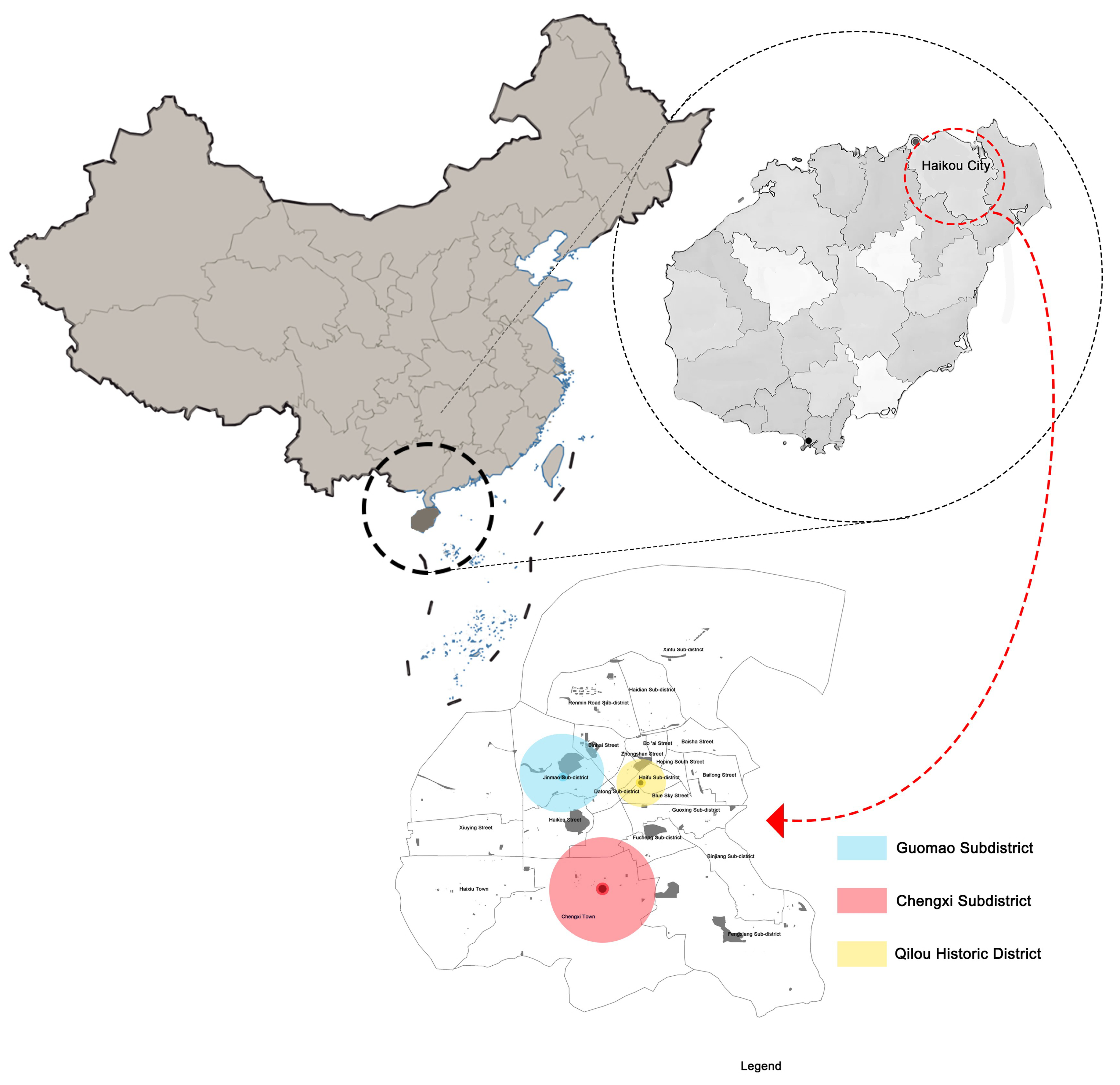
Figure 1. Study in Haikou, China.
Sustainability 17 07480 g001
Figure 2. Analysis of Safety Evaluation.
Sustainability 17 07480 g002
Figure 3. Analysis of Comfort Satisfaction.
Sustainability 17 07480 g003
Figure 4. Resident Improvement Needs Analysis.
Sustainability 17 07480 g004
Figure 5. Resident Facility Needs Analysis.
Sustainability 17 07480 g005
Figure 6. Flowchart.
Sustainability 17 07480 g006
Figure 7. Green.
Figure 7. Green.
Sustainability 17 07480 g007
Figure 8. Traffic Legend.
Sustainability 17 07480 g008
Figure 9. Functional Density Map.
Sustainability 17 07480 g009
Figure 10. Population.
Sustainability 17 07480 g010
Figure 11. Land Use Mix Map.
Sustainability 17 07480 g011
Figure 12. Architectural.
Sustainability 17 07480 g012
Figure 13. Policy–Design–Community Synergy Framework Diagram.
Sustainability 17 07480 g013
Figure 14. Location of Zhenlongfang (The image is from Google Maps).
Sustainability 17 07480 g014
Figure 15. Site Analysis Diagram of Zhenlongfang.
Sustainability 17 07480 g015
Figure 16. Temple-Centered Community Layout in Hainan.
Sustainability 17 07480 g016
Figure 17. Modular Furniture Applicable to Public Spaces.
Sustainability 17 07480 g017
Figure 18. Integration of Greenery with Modular Furniture.
Sustainability 17 07480 g018
Table 1. Evaluation Index System for Modular Design.
Indicator NameCalculation Logic or Survey MethodEvaluation DimensionCase Illustration
Functional Diversity per Unit AreaNumber of functional categories or a composite score of functional diversity per unit area.High/Medium/Lowe.g., A 100 m2 space containing more than three functional zones is rated High; two is Medium; one is Low.
Flexibility of Modular CombinationsDegree of variation in modular unit combinations and the adaptability of spatial layouts.High/Medium/Lowe.g., Movable modular partitions that can be reconfigured for multiple uses are rated High; fixed, non-adaptable layouts are Low.
Construction Time Reduction RatePercentage reduction in construction time compared to traditional methods = (Reduced Time/Traditional Time) × 100%.High/Medium/Lowe.g., Modular assembly takes 6 months, which shortens construction time by 40% compared to traditional methods, rated High.
Improvement Rate of Resident SatisfactionIncrease in survey-based satisfaction score before and after renovation = (Post-Renovation − Pre-Renovation) × 100%.High/Medium/Lowe.g., If satisfaction improves by n%, and n > 20, it is rated High.
Ecological Improvement IndexChange in NDVI or equivalent greening coverage before and after intervention.High/Medium/Lowe.g., NDVI increased from 0.32 to 0.39 after adding modular green walls and planters, an improvement of +0.07, rated High.
Table 2. Modular Design Evaluation Table for Zhenlongfang.
IndicatorValueRating
Functional Diversity per Unit Area1.2 per 100 m2Low
Flexibility of Modular CombinationsOnly 1 feasible layoutLow
Construction Time Reduction RateEstimated 22% via prefabricated fencingMedium
Improvement Rate of Resident SatisfactionSurvey score increase potential: 2.1 → 3.5High
Ecological Improvement IndexNDVI = 0.08Low
Disclaimer/Publisher’s Note: The statements, opinions and data contained in all publications are solely those of the individual author(s) and contributor(s) and not of MDPI and/or the editor(s). MDPI and/or the editor(s) disclaim responsibility for any injury to people or property resulting from any ideas, methods, instructions or products referred to in the content.