1. Introduction
The issue of achieving carbon neutrality in urban areas is highlighted by relevant international agendas, which call for urgent action to contain global temperature, reduce dependence on fossil fuels, and promote renewable energy [
1,
2].
Urban planning can significantly reduce greenhouse gas emissions and promote sustainability by integrating climate action into existing policies and plans: spatial data mapping supports evidence-based planning and the response–demand approach; knowledge sharing allows citizens to be involved and community-led initiatives to be promoted; urban regulations and legislation can set greenhouse gas reduction targets, incentivize energy efficiency and the transition to renewable energy [
3].
In this scenario, EU countries are already obliged to reduce emissions by 55% compared to 1990 levels by 2030, and to achieve carbon neutrality by 2050 [
4].
However, to stay on track with these targets, the EU needs to accelerate the pace of change and increase focus on areas where the required emission reductions are significant, such as buildings and transport [
5].
The target of zero CO
2 emissions by the established date is also an obligation for the European areas identified with the term “inner peripheries”, which are experiencing the challenge of depopulation, of the increasing dependence on urban poles offering services of general interest [
6] and for which responding to the challenge of carbon neutrality is more burdensome.
As a promising tool to address these global issues, Renewable Energy Communities (RECs) emerge, coalitions of citizens, small and medium-sized enterprises, and local authorities, which cooperate to produce, consume, and share energy produced locally from renewable sources, according to rules established in agreement between all members, with the main aim of providing environmental, economic, and social benefits to the community itself or to the areas in which it operates, rather than financial profits [
7].
To confirm the benefits potentially brought to sustainability of urban areas, experiments in the USA and Europe show the REC advantages in terms of energy efficiency of existing buildings, increase in the use of renewable energy, reduction of CO
2 emissions, and the fight against energy poverty [
8,
9,
10,
11,
12,
13].
RECs become even more effective in achieving these sustainability goals when associated with the concept of Positive Energy Districts (PEDs). According to the definition given by the European Innovation Partnership on Smart Cities and Communities, a PED is a geographically defined urban area, composed of buildings of different types and public spaces, such that the total annual energy balance must be positive. This feature allows the district to have extra energy production that can be shared with other urban areas.
Directive EU/2001/2018, known as “RED II”, part of the Clean Energy for all Europeans regulatory package, obliges Member States to promote RECs, assessing their obstacles and development potential in their territories, as well as facilitating them with an adequate framework of support and incentives at all levels, from the national to the local [
7].
In Italy, RECs were introduced by Decree-Law No. 162 of 30 December 2019, while the “RED II” Directive was subsequently transposed by Legislative Decree No. 199 of 8 November 2021, pursuant to which Italian RECs must comply with specific spatial and technical constraints in order to obtain economic incentives, in particular connection to the same primary substation, i.e., medium–high voltage, for all potential members, as well as using renewable energy production plants (RESs) with a capacity not exceeding 1 MW each. Like all self-consumption configurations, RECs must exchange the energy produced and shared through the existing public grid, unlike independent or “off the grid” configurations. The latter, often promoted for the most remote areas not served by the public network, as is the case in other countries [
14], are legally possible in Italy but benefit from different economic incentives.
The Italian incentives provided for RECs are more advantageous, because they concern the energy self-consumed by members in two forms: a tariff, recognized by the Italian National Energy Service Operator (GSE), between €60/MWh and €120/MWh, with a surcharge of up to €10/MWh in the case of photovoltaic plants, the latter valid only in Central-Northern Italy, for a period of 20 years from the date of entry into operation of each RES plant; an incentive of approximately €8/MWh from the Regulatory Authority for Energy, Networks and the Environment (ARERA).
Recently, with Ministerial Decree No. 414 of 7 December 2023, issued in implementation of the decree transposing the European directive, and with the clarification of the state aid provided for by the Italian National Recovery and Resilience Plan (NRRP), the regulatory framework and incentives provided for in the field of RECs has been clarified. In particular, the NRRP reserves additional incentives for RECs in municipalities with a population of less than 5000 inhabitants: in addition to an incentive tariff for renewable energy produced and shared in the national territory, in these municipalities there is also a non-repayable contribution of up to 40% to support the installation of RES plants [
15]. The main purpose underlying this additional support measure is to counter the demographic decline taking place in these municipalities: in Italy, the so-called “inner areas”, whose problems of demographic desertification and dependence on urban centers offering the main services represent the national translation of the critical issues attributed to the European “inner peripheries”, are present above all in the regions of Southern Italy and on the whole are 82.1% consisting of municipalities with less than 5000 inhabitants [
16].
Although RECs are widely favored as part of Green Deal initiatives, their uptake in Member States is limited, as shown by a recent EU report on this issue. Among the main obstacles identified in the report are the difficulty of involving potential community members; the lack of expertise to localize REC projects; urban planning obstacles, in terms of constraints, intended use, and previous building rights, in the authorization process of projects; and the absence of incentives at local level [
17].
Even in the Italian case, mainly due to a national regulatory framework defined only recently, RECs are struggling to take off, while those implemented are disconnected from general and local energy planning processes [
18]. The latter, from a probable obstacle, can evolve into a process favorable to the diffusion of RECs in urban areas, offering a transparent and accessible cognitive framework for citizens about the benefits brought, the territorializability of REC projects, as well as adequate incentives integrated at the local level through a package of tools and general and energy plans.
2. Related Works, Literature Gaps, and Aim
The relationship existing in the international academic literature between RECs and urban planning has been explored by Gerundo & Marra [
19]. The study, published at the end of 2022, showed that almost all the works examined concerned the search for optimal RECs configurations, to support planners. However, the aspects considered most were energy, technological, and economic convenience, neglecting the issues related to urban planning, addressed in a few studies [
20,
21,
22,
23].
In continuity with the work previously mentioned, the same search criteria were used, with the help of the Scopus and Web of Science engines, choosing “energy communities” and “urban planning” as keywords, but with reference to the following time period. Additional criteria have been defined in order to exclude non-assessable products (e.g., publications with abstracts not in English, posters) or out-of-scope products, after a thorough reading of the publications in their entirety.
This research, more up-to-date, resulted in a further thirty-eight relevant works, classified into two main clusters and six subclusters, on the basis of the prevailing themes, although each publication has its own specificities compared to the others.
More precisely, the first cluster (Cluster 1) concerns the overall optimal design and REC modeling, as the chosen studies address the following issues:
Energy supply–energy demand intersection [
24,
25,
26,
27,
28,
29,
30,
31,
32,
33,
34,
35];
Economic feasibility [
14,
36,
37];
Design support tools and software [
38,
39].
The second cluster (Cluster 2) concerns public action and plans for REC promotion, and scholars focus on some main themes:
Regional, provincial, urban, and district plans [
52,
53,
54,
55,
56].
With reference to the latter subcluster, concerning urban and territorial plans, it is possible to further divide some of the works of Italian researchers according to the study contexts; on the one hand, characterized by high cultural and landscape value [
57,
58,
59], on the other hand, by conditions of socio-economic disadvantage and/or energy poverty [
19,
60].
Among the studies of the first and second clusters, some deal with the link between REC and PED, the results being particularly significant for this research.
Mussawar et al. understand RECs as a means to contribute to the achievement of urban sustainability goals such as energy self-sufficiency, through plans and policies. Using an agent-based model, they analyze the performance of different urban district archetypes: compact, open areas with high, medium, and low density. The results show that unlike high-density areas, medium-density areas were unable to achieve 100% self-consumption in the community mode [
29]. Hachem-Vermette and Singh identify six archetypes of urban districts, both newly built, more sustainable, and traditional construction, typical of the North American context examined (Canada). With the help of EnergyPlus software, they assess the energy demand and study how to optimize the production and sharing of energy between the districts, so that those in surplus energy can absorb the deficit of the others, at least in part [
28]. A similar approach, applied in Southern Italy, is proposed by Aruta et al. but at a more granular scale: archetypes are buildings representative of an urban district of the city of Naples. In that case, in addition to EnergyPlus (v9.4), the authors also use Geographic Information Systems (GISs) to visualize information on urban energy maps [
30].
Trevisan et al. propose a general framework to support the creation of RECs, based on a governance model that can be replicated in different contexts, including that of PEDs. The first phase of the model concerns the initial planning, which includes the identification of potential members, prototyping and feasibility of configurations, and the expected economic and energy benefits [
32]. Leone et al. focus on the integration of RECs in urban planning, with particular reference to landscape planning, using the small municipality of Corsano (Lecce) as a case study. Scholars converge on the energy district as a projection of the local community, in order to enhance the strategic vision of urban energy planning [
55].
From these state of the art studies, briefly outlined, some limitations emerge, which the present study aims to address. First of all, it can be pointed out that almost all the works examined start from a predefined geographical spatial perimeter, within which they study and/or optimize the technical, technological, and/or economic feasibility of a REC, sometimes integrating aspects related to environmental sustainability. Few studies investigate what the optimal geometry of potential RECs may be without defining their spatial perimeter a priori. Therefore, the majority of the examined research facilitates a REC’s optimal design but does not support the phase that precedes the project, useful for the territorialization of the project itself in the optimal place. Secondly, many studies see local authorities, municipalities in the case of Italian works, as ideal leaders in conducting the REC activation process, in accordance with a top-down approach. This is especially relevant in particularly critical areas, such as those afflicted by social and energy poverty, where the initiative of individual citizens can be hindered by deprivation conditions [
19,
61].
However, considering the ambitious goals set by the European Commission regarding the achievement of carbon neutrality in urban areas, it is relevant to understand how RECs can find a wider diffusion. To have tangible results on large territories, it is necessary that public action is accompanied by private initiative, according to a bottom-up approach.
To this end, the main objective of this work is to propose a methodology aimed at locating REC spatial-geographical configurations, optimal from the point of view of their territorialization. The methodology is applied to the study area of the Province of Avellino, in the Campania Region, Italy. This area of application is emblematic to experiment with the opportunities offered by RECs not only for achieving carbon neutrality in urban areas, but also for combating the depopulation and decline of inland areas, in line with the approach underlying the NRRP.
3. Methodological Proposal
The approach underlying the methodology proposed here takes as a reference two relevant paradigms of urban planning in the current global scenario: the achievement of carbon neutrality on a large scale and the minimization of new land take, preferring the location of RES plants serving RECs in existing urban fabrics.
In order to encourage private initiative as a support for public action, it should be considered that, unlike local authorities, private individuals do not generally have the general interest as their primary objective, but look at their own economic convenience, with particular reference to investments in new energy infrastructure, as well as savings on bills [
62,
63].
This awareness, combined with the need to avoid new land consumption, led to the choice of photovoltaic panels on the roofs of existing buildings, among all the possible RES systems that can be chosen. The panels represent an economical technological solution compared to other types of RES systems. Furthermore, if they fall within suitable areas, in Italy, these plants can be built in free construction, i.e., they can be installed without qualifications or authorizations that could slow down the process of REC activating. Moreover, solar energy is widely favored in national and international REC experiences [
18,
36,
64], as well as in the majority of academic studies reviewed in the previous section, a sign of concrete feasibility on a large scale.
In addition, to identify RECs’ optimal configurations, it is necessary to clarify how to identify the geographical spatial unit of reference, i.e., determined by a minimum aggregation of potential community members. In this study we intend to intersect the concept of REC with that of PED. Therefore, according to an approach that can be defined as PED-based, an urban district represents the minimum REC territorial unit. This implies that by setting up a district REC, the energy supply present can meet the demand of the entire district, even though the latter is partially affected by areas not suitable for the installation of RES plants.
So, if a district fails to be almost self-sufficient, instead of forming a REC individually, it can join other urban districts in a larger REC, which can guarantee a supply that meets the overall energy needs. In other words, more urban districts aggregate into larger territorial units of RECs, in order to maximize energy self-sufficiency on a larger scale.
To ensure broad transferability to the proposed methodology, it is proposed to make the minimum urban district coincide with the census tract (also called census section), since for this geographical spatial perimeter, there is data available useful for calculating energy supply and demand.
That said, the methodology for identifying optimal REC configurations is divided into different phases, which involve the construction of the following maps:
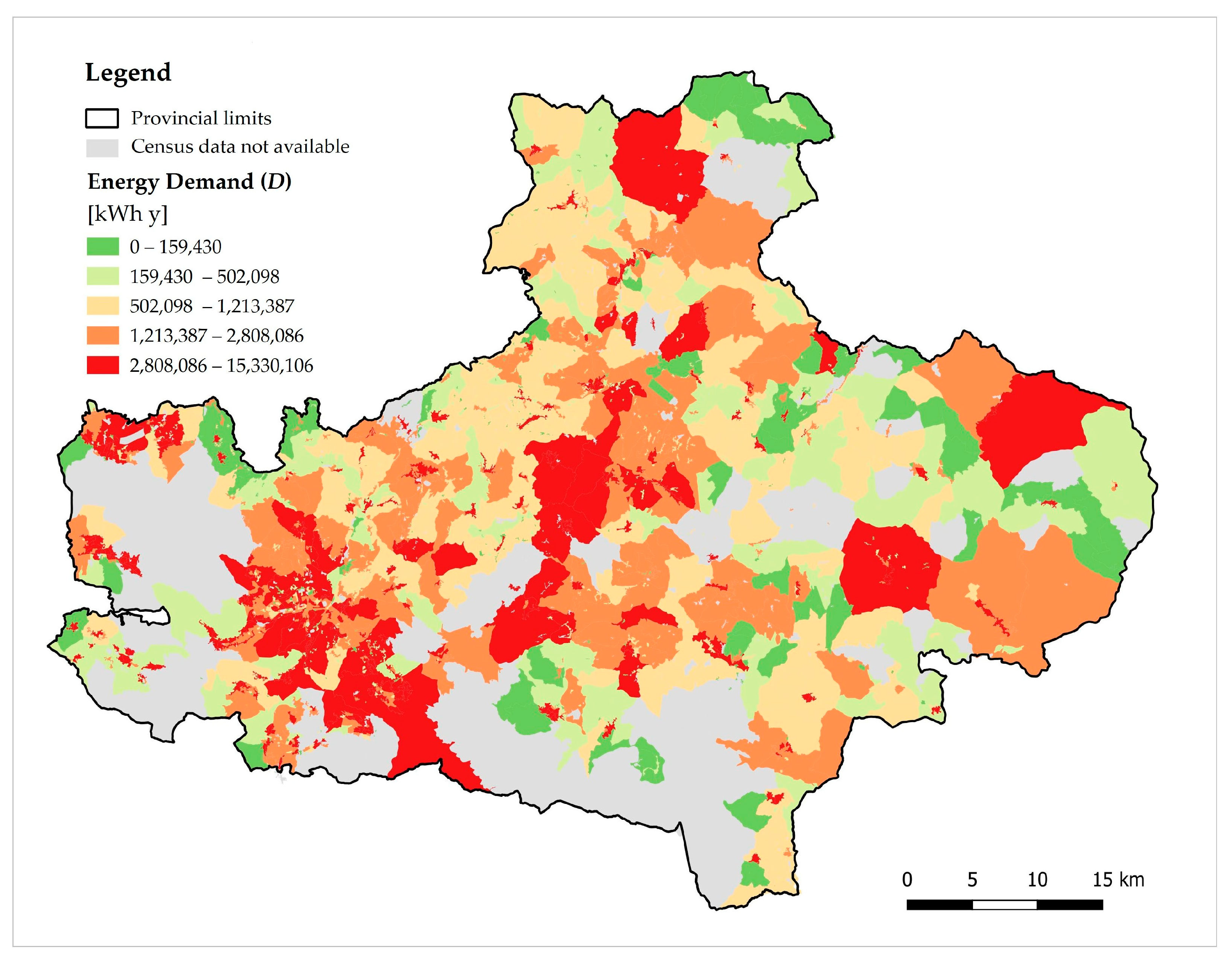
Map of energy demand (D);
Map of selected RES suitable areas;
Map of energy supply (O);
Map of supply–demand balance (D-S);
Map of optimal REC configurations.
The above methodological steps are better specified below (
Figure 1).
3.1. Map of Energy Demand
At the international level, the technical-scientific literature recognizes Energy Performance Certificates (EPC) as a reliable source of knowledge of building consumption [
65].
The consumption data, average values for the Italian national territory relating to the Global Non-Renewable Energy Performance Index (
), can be extracted from the “National Cadastre of EPC (SIAPE)” by setting some parameters, such as the climatic zone, use, and age class of the building [
66].
The spatial knowledge of these parameters is available by municipality, in relation to the climatic zone, and on a census basis for the remaining parameters. The articulation of the age groups on a census basis differs slightly from that present on SIAPE. However, it is possible to make an association between the two to make them consistent (
Appendix A). Therefore, once the climatic zone (
Cz) and only the residential use are established in each
s-th census tract (with
s = 1, …, t), there are
a age classes (with
a = 1, …, 5). For individual buildings belonging to the same age class, the information about the
index is extrapolated. A certain number of buildings
ba fall into each age group (
Table 1).
To calculate the average energy consumption for each tract (
), a weighted average of the
index values can be made, where the weights are represented by the number of buildings in each age class (1).
However, the value calculated in this way cannot be compared with the identification value of the offer to carry out the supply–demand balance operation. To this end, it is necessary to multiply the consumption value thus obtained by the useful surface area of the dwellings, a census variable that can be associated with the heated and/or cooled surface of the residential buildings in the same tract. In this way, it is possible to determine the energy consumption (D) expressed in kWh y, representative of the demand, on a census basis.
3.2. Map of Selected RES Suitable Areas
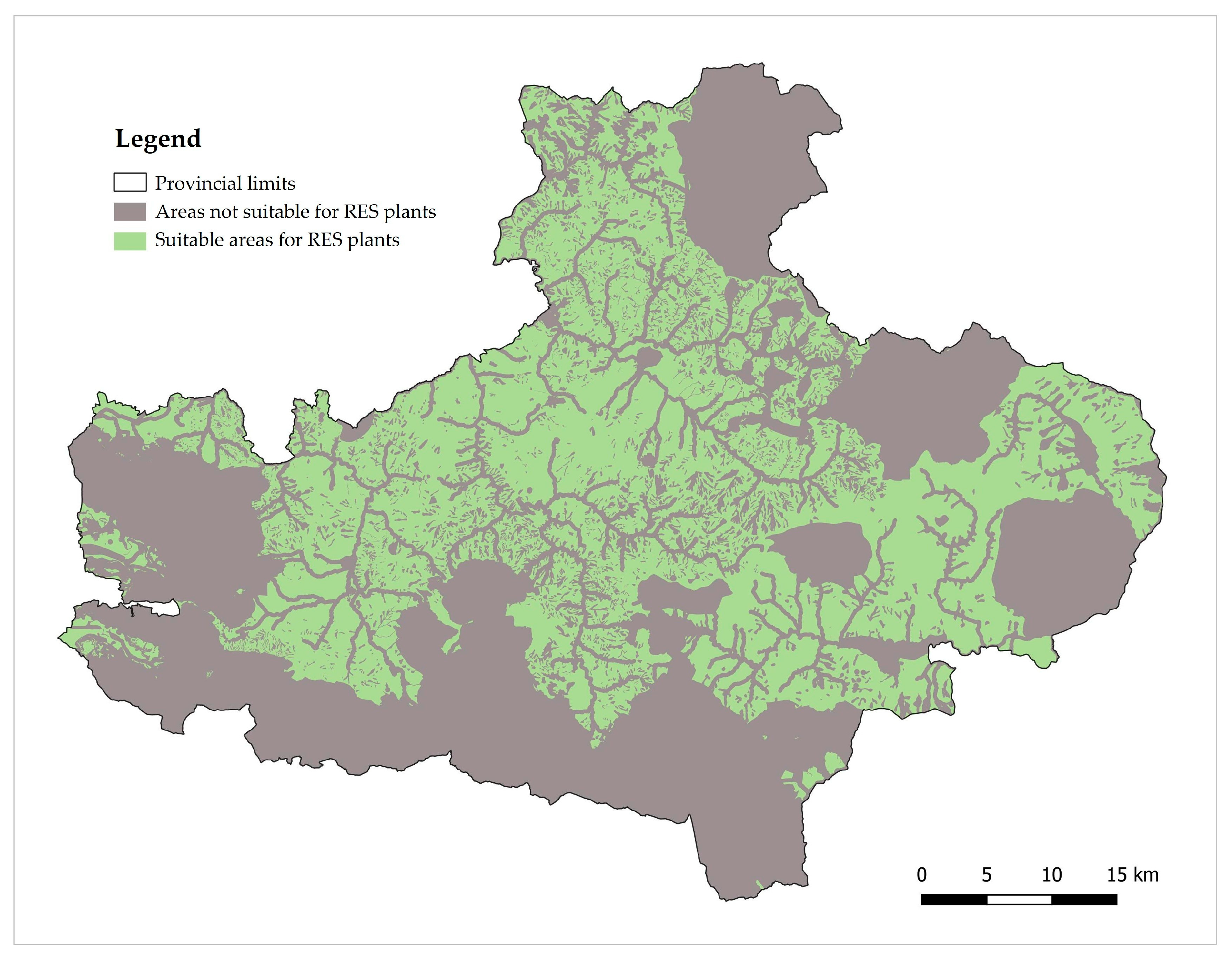
Taking into account the approach underlying the proposed methodology, which led to the choice of photovoltaic panels on the existing buildings roofs, in this step a method is proposed that is based on the recognition of the areas not suitable for this type of plant, in order to indirectly map the suitable areas. In Italy, the rule that currently regulates the construction of photovoltaic systems on roofs is Legislative Decree No. 190 of 25 November 2024, according to which existing buildings located in areas characterized by particular landscape, environmental or historical–cultural values are to be excluded: historic centers; areas and buildings declared of significant cultural or landscape interest; areas included in protected natural contexts; sites belonging to the European ecological network Natura 2000; areas subject to specific environmental, hydrogeological or seismic protections; the sites recognized as UNESCO World Heritage Sites.
This spatial knowledge is offered by the general municipal urban plan, which is a mandatory planning tool for municipalities and must include this information in its contents [
19]. In a vast area, this cognitive framework is available in the general plan at provincial level, which is called the Provincial Territorial Coordination Plan. However, when these data are not present due to the absence or obsolescence of the current plan, it is possible to map them individually on the basis of the respective reference laws. Soon, Italian municipalities will be able to access a national platform to support the identification of suitable areas by the GSE [
67].
3.3. Map of Energy Supply
The offer consists of the amount of renewable energy that can be produced by photovoltaic panels that can be installed on the roofs of existing buildings in suitable areas. It can be estimated through the following sub-steps:
Mapping of suitable buildings, i.e., falling within suitable areas;
Estimation of the area available for localizing the panels in each census tract;
Estimation of energy production per tract.
The first sub-phase requires spatial knowledge of buildings, which can be obtained through the National Land Consumption Map by the Italian Institute for Environmental Protection and Research (ISPRA), filtering the “buildings” theme [
68]. Since this map is in raster format, the layer is vectorized in a GIS environment, so as to obtain polygons representative of the buildings’ covered surfaces.
In order to consider only buildings for residential use, the vectorized layer of the buildings is intersected with the census sections corresponding to the inhabited localities identified with code “1”, “2”, “4” being the inhabited localities and with code “3” relating to the production areas. The buildings map, thus obtained, is then intersected with the map of suitable areas previously described, in order to identify the buildings actually suitable for the installation of the panels on their roofs.
The second sub-phase involves estimation of the surface area available for hosting the panels. This area can be obtained by reducing the total covered area of the eligible buildings falling within each census section by 70%. So, for each section, only 30% of the roof surface of residential buildings falling within suitable areas is considered usable. The value of 30% is proposed by ENEA, based on in-depth studies on the consistency of existing Italian buildings. This allows factors such as shading, technical spaces, chimneys, antennas, and other structures on roofs to be taken into account [
69,
70].
In the third sub-phase, it is first necessary to calculate the maximum number of panels that can be installed in each census section (), given by the ratio between the available surface area referred to in the previous step and the surface area of a single panel. This evaluation requires the prior choice of the type of panel to be installed: it is possible to consider a photovoltaic panel with a nominal power of 300 W, a surface area of 2 m2 and an efficiency of 18.4%, a solution similar to many others on the market and widely used. Subsequently, for the calculation of the energy that can be produced by the panels, it must be considered that, depending on the geographical context, the number of sunshine hours per year varies. Knowing these data, it is possible to calculate the energy produced annually by a single photovoltaic module () as the product of nominal power () and annual hours of sunshine (). Finally, by multiplying the value of , thus obtained, by the number of panels that can be installed in each section (), it is possible to estimate the energy production per section, corresponding to the supply (O).
3.4. Map of Supply–Demand Balance
Knowing the energy demand (
D) and supply (
O) for each section, it is possible to carry out a balance operation, according to the formula specified below (2).
where
= Difference between energy supply and demand;
= Energy produced per section, corresponding to the supply;
= Energy consumption per section, corresponding to the demand.
Depending on the result of the operation, we can distinguish two cases:
If , the section is classified as a PED;
If the section is classified as an NED.
3.5. Map of Optimal REC Configurations
In order to identify optimal REC configurations, the map of the primary substations is considered, starting from the data made available by the GSE. According to the Italian legislation in force on RECs, potential users of the communities receive economic incentives if their buildings or, rather, the connection points to the national electricity grid (POD), are located in the area served by the same primary substation.
Once the perimeters of the primary substations are known, it is possible to search for optimal REC configurations within them. However, the possible aggregations between the sections are many, so it is necessary to establish aggregation criteria to govern the problem. Although the law does not clarify the exact meaning of “spatial proximity” from the definition of REC, it can be deduced that the potential aggregations are given by at least two contiguous or in any case spatially close districts. In fact, this can facilitate neighborly relationships, encouraging the voluntary adhesion of potential members [
71].
Furthermore, in accordance with the PED-based methodological approach enunciated, a further criterion can be established: namely, that the optimal aggregations, resulting from the aggregation of several districts, are at least energy self-sufficient, preferably with positive energy. This implies that the PEDs present in the potential optimal aggregation are at least able to fill the deficit of the NEDs belonging to the same aggregation, starting from the closest ones. The process is necessarily iterative, as shown in
Figure 1.
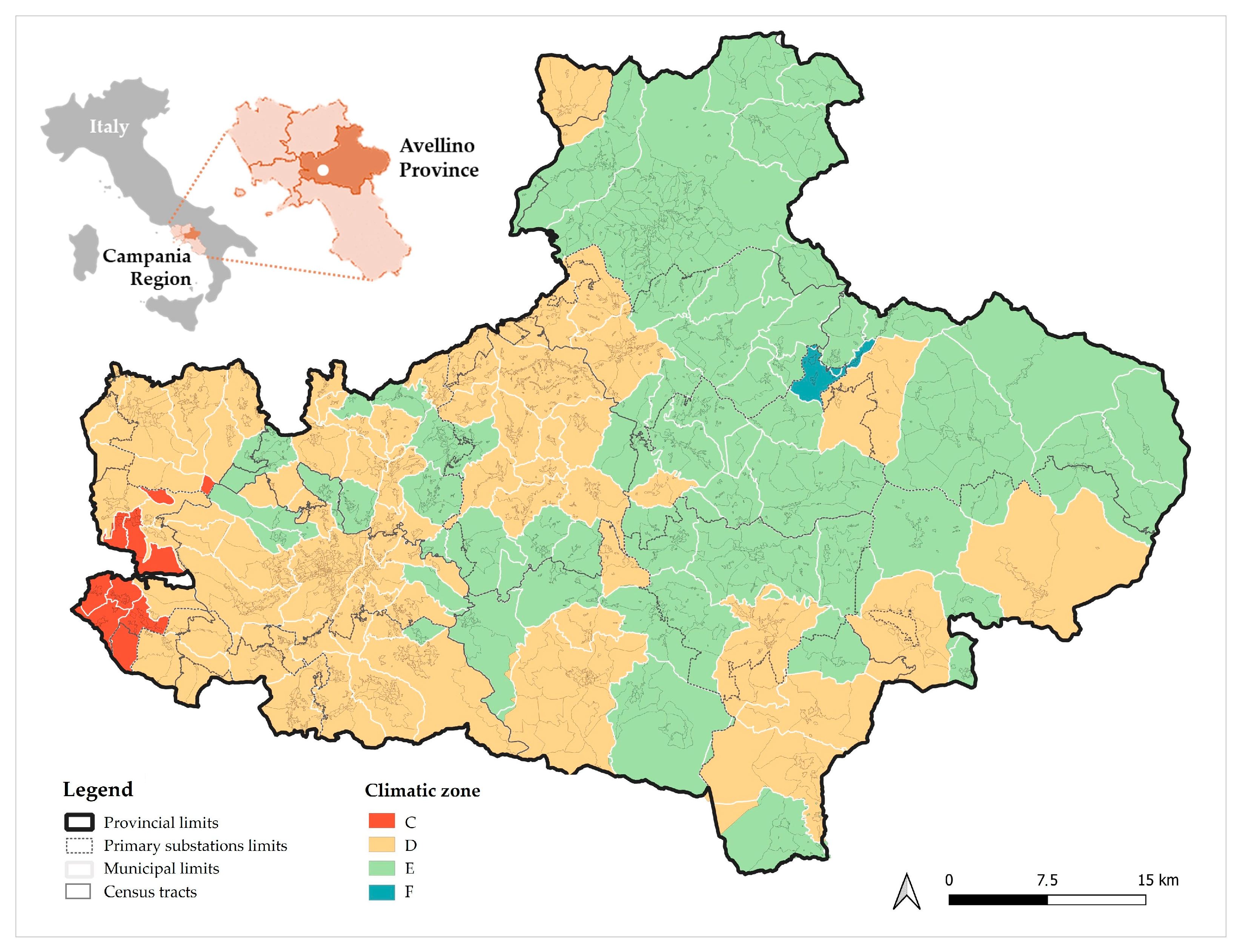
4. Case of Study
The provincial area of Avellino is in the central stretch of the Italian Apennines and has 394,759 inhabitants at the end of 2024 according to ISTAT data (
Figure 2).
Although this province has a significant territorial extension, which makes it second among the provinces of Campania after that of Salerno, it suffers from a significant demographic decline, which translates into a population density of only 140.76 inhabitants/km2. In fact, out of the total of 118 municipalities that compose it, only 7 exceed 10,000 inhabitants, all located around Avellino, which, despite being the provincial capital, has a population of just 51,910 residents.
In Italy, the Regions can issue laws that regulate the planning system for their regional territory of competence, by convention defined as Regional Urban Planning Laws (RULs). The RUL of the Campania Region, recently updated, place among the priority objectives of urban and regional planning “the promotion and incentive of energy saving, the production and distribution of energy from renewable sources and the energy efficiency of the existing building stock” [
72].
To get an idea of the contents potentially relevant to the subject matter of a Municipal Urban Plan (PUC), it is useful to investigate what the recommendations are for such plans contained in the provincial general plan. The latter, called the ‘Provincial Territorial Coordination Plan (PTCP)’, provides development strategies at the provincial level, with respect to which the provisions of the PUCs must be consistent according to the legislation in force in the Campania Region. The term “Renewable Energy Communities” is not present, probably because the Avellino PTCP was approved in 2014, before the “Red II” Directive. However, the plan seems to implicitly favor its diffusion. In fact, as can be read from the Technical Standards for the Plan Implementation, “the Province promotes the creation of local energy systems based on the decentralized production of energy and on efficient and intelligent management of the same”. In addition, the plan specifies that “the Sector Plans and the Municipal Urban Plans are consistent with the PTCP and provide for specific energy qualification actions of existing and new settlements”. To this end, the municipalities must promote a high level of sustainability for new buildings and support energy saving interventions on the existing building stock through incentives and volumetric bonuses [
73,
74].
For this work’s purposes, it is useful to recall that the Avellino PTCP pursues a logic of collaborative co-planning with the municipalities, also taking into account their limited size in terms of population. This logic is reflected in the methodological approach underlying the perimeter of the PTCP “City Systems”, understood as homogeneous inter-municipal areas, for which it is possible to identify common development strategies, to be implemented in the PUCs, also by fostering inter-institutional synergies [
75,
76].
5. Results
The application of the proposed methodology to the case study of Avellino Province required data processing with the use of QGIS (v3.40.4) [
77] and ArcGIS software (v10.8) [
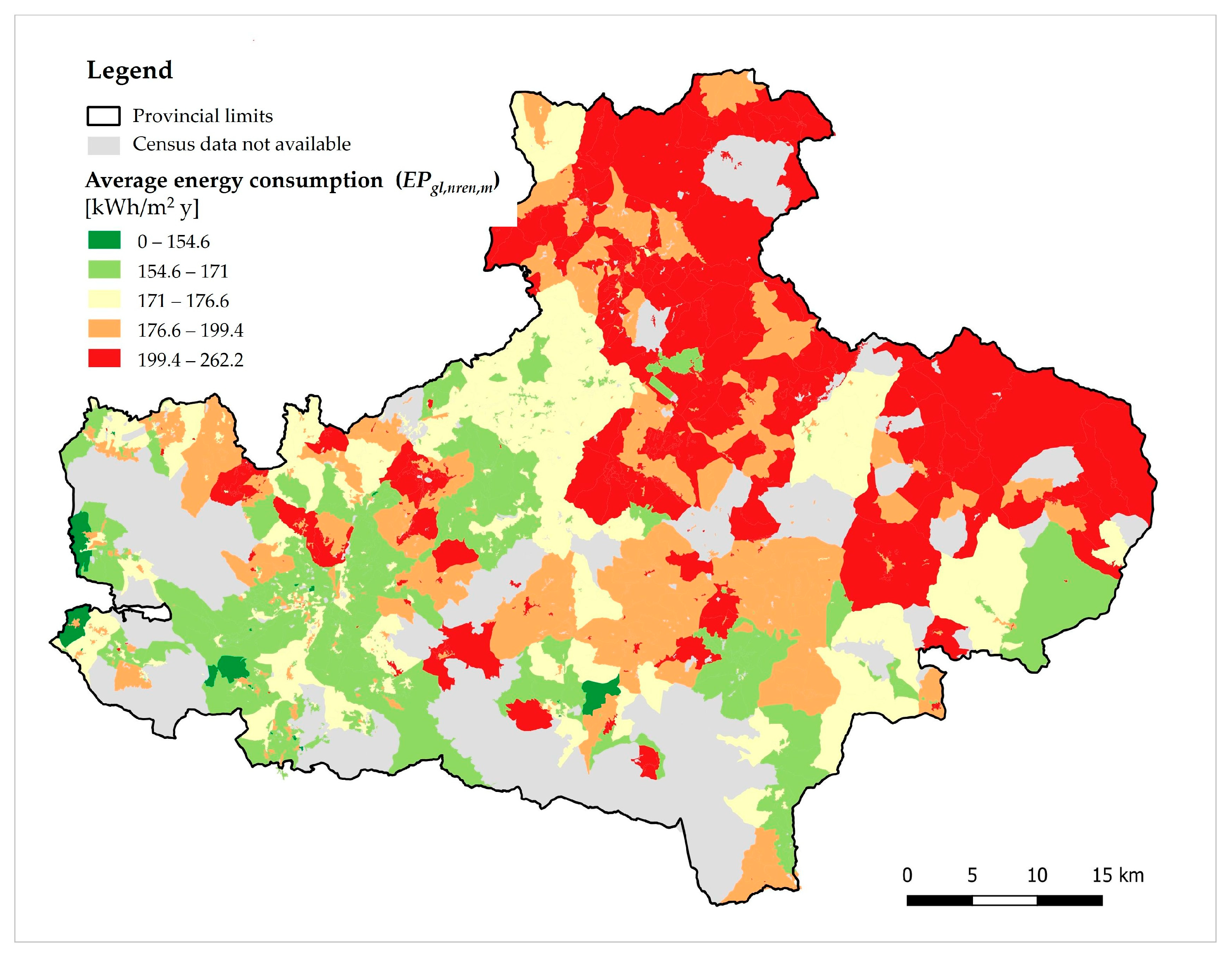
78], which allowed us to manage geographical data and to obtain, as output, the maps to which the various methodological steps lead. The municipalities of the Avellino Province belong to climatic zones C, D, E, and F. Therefore, with reference to the first methodological step, the map of energy consumption was obtained, spatializing the values of the
Index extracted from SIAPE on a census basis (
Figure 3). These values, multiplied by the dwellings’ useful surface area, made it possible to estimate the demand, obtaining the map of energy demand (
Figure 4).
Comparing the two maps, it can be seen that some areas characterized by not particularly high consumption have a higher demand than areas with high consumption. This is the case of the eastern portion of the province, which includes the capital municipality of Avellino, joined to the neighboring municipalities by a conurbation, where the highest population density is concentrated. Therefore, the usable floor area of dwellings is larger, which explains the discrepancy between consumption and demand in these areas.
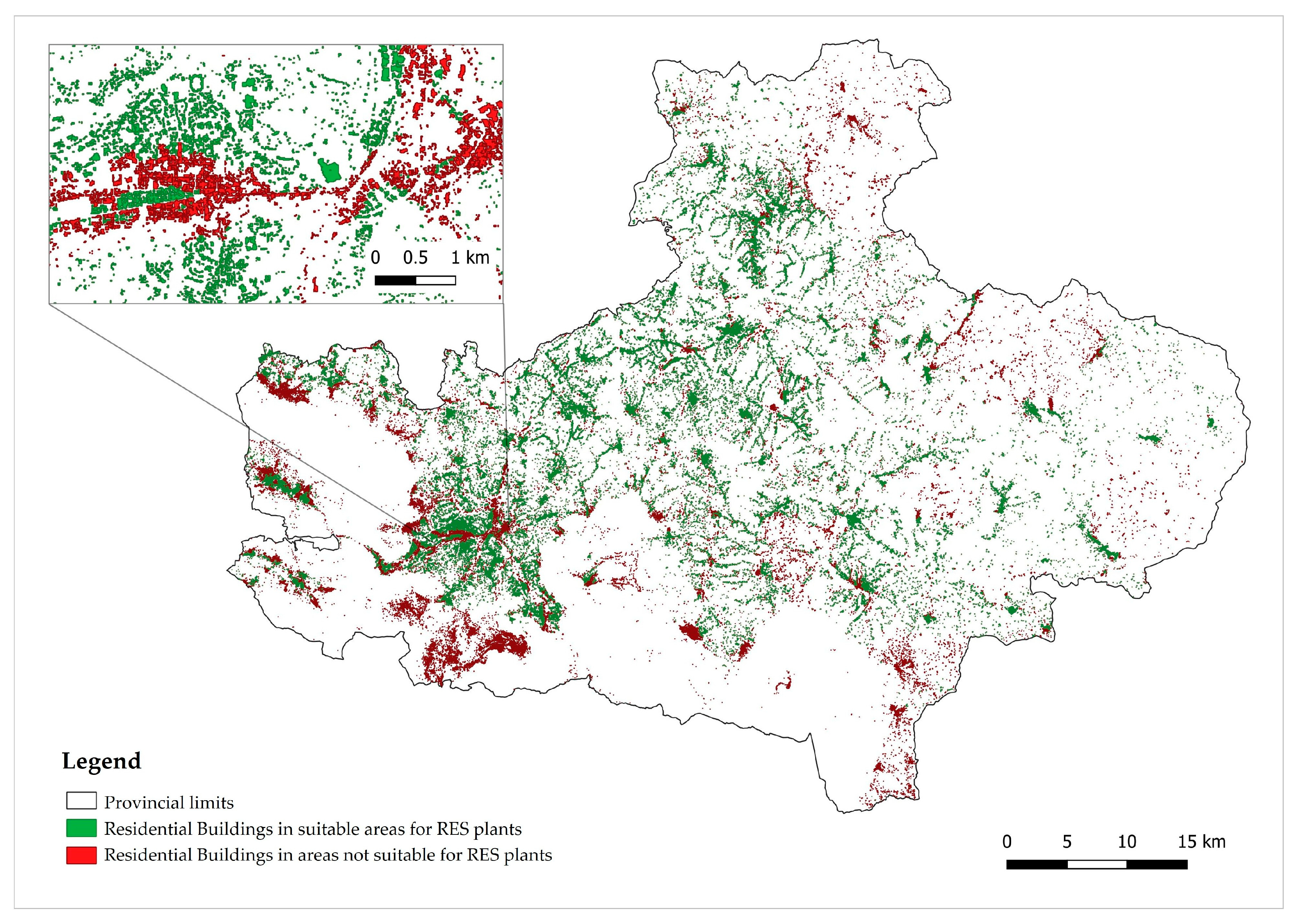
The exclusion areas for the location of photovoltaic panels identified for the area under study cover 57.4% of the total surface area of Avellino Province. They include: the “A zones” of the municipal urban plans, corresponding to historical centers; the cultural and landscape heritage protected by the relevant Italian legislation on the matter, the Legislative Decree No. 42 of 2004; all protected natural areas, including those belonging to the Natura 2000 Network; UNESCO sites; and the areas with the highest hydrogeological hazard and risk. By subtracting these unsuitable areas, it was possible to identify the areas suitable for the selected RES plants’ installation, equal to 42.6% of the provincial area, creating the map of selected RES suitable areas (
Figure 5).
The latter map was then intersected with that of the existing predominantly residential buildings, obtaining the map of buildings suitable for the installation of photovoltaic panels on their roofs (
Figure 6). Suitable buildings represent 56.7% of the total number of buildings considered.
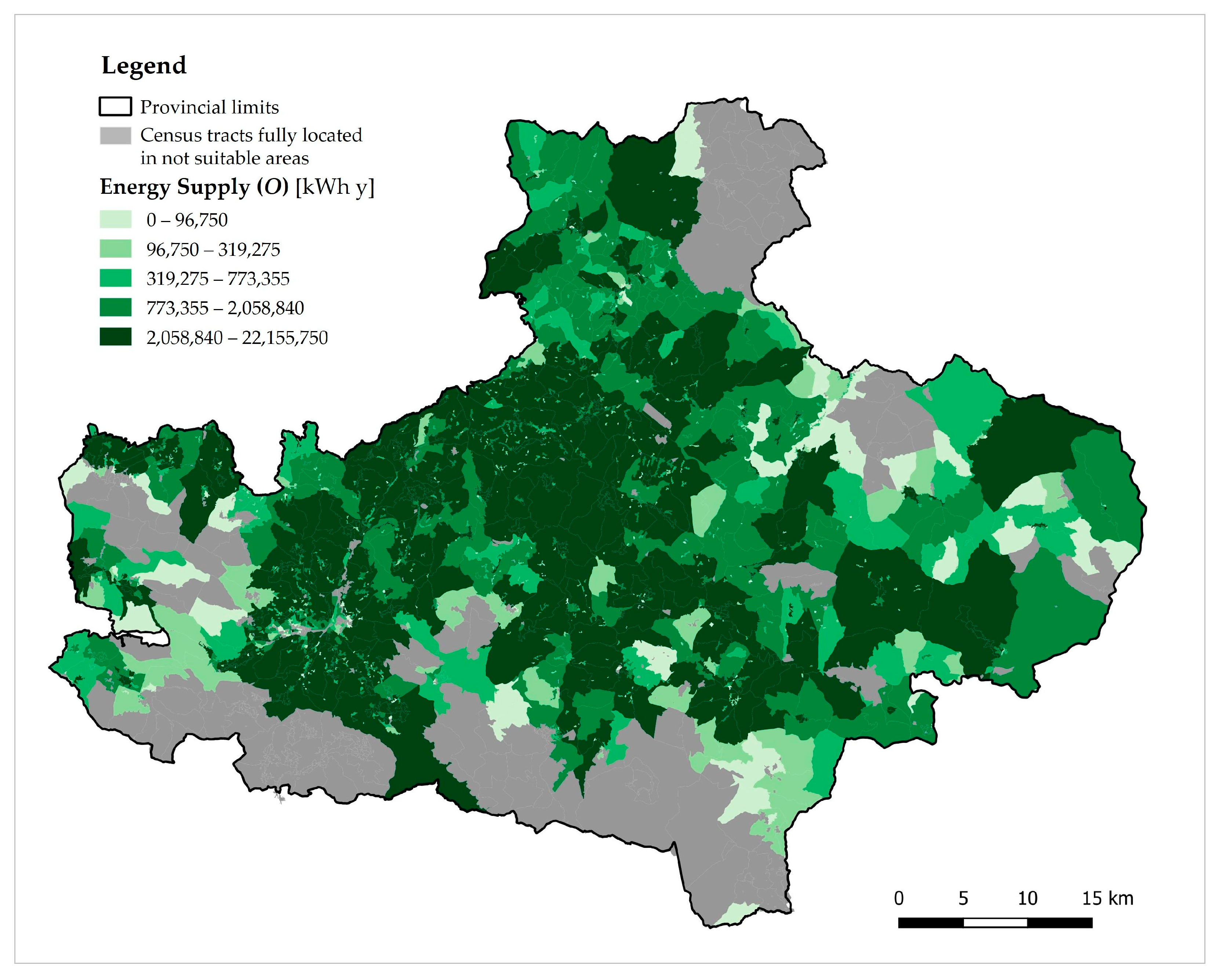
Considering only 30% of the roof surface of these buildings, the area available for hosting the panels was assessed and, consequently, the number of panels was estimated. The relative calculated producibility for each census tract is shown in the map of energy supply (
Figure 7).
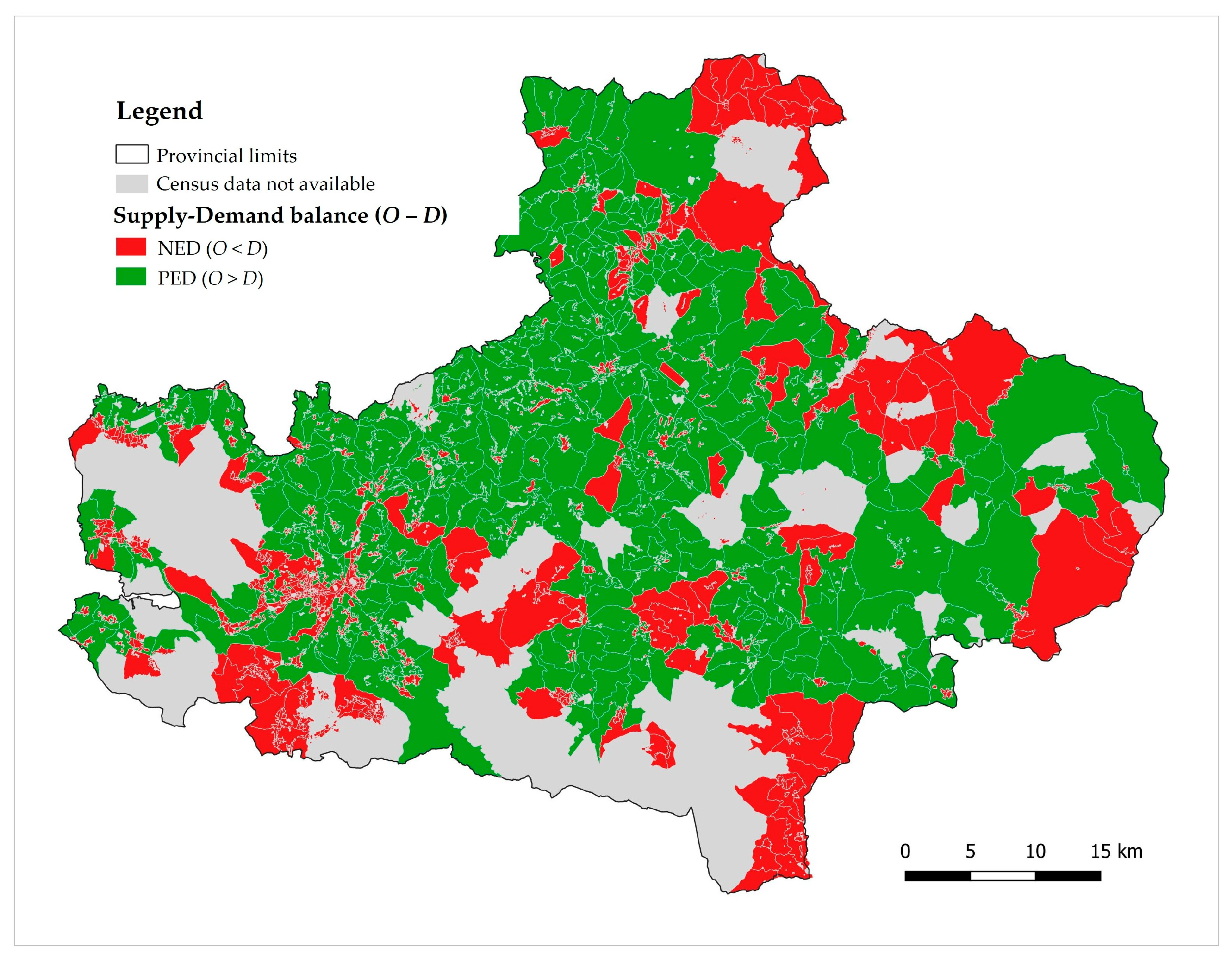
Once the supply and demand had been calculated, it was possible to proceed with the algebraic difference between the two factors, obtaining the map of supply–demand balance (
Figure 8).
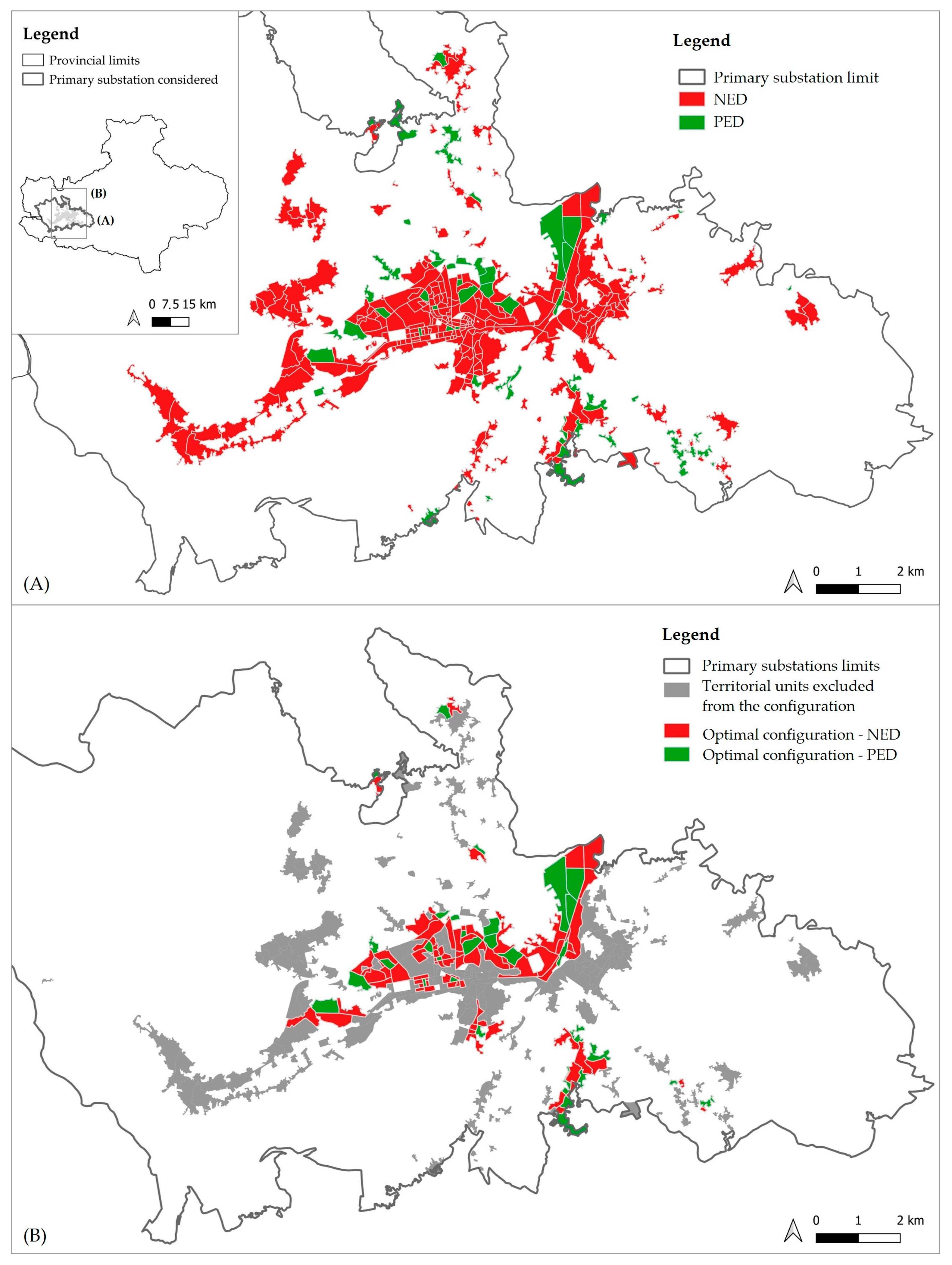
As an example, the application of the last methodological step was limited to the area of the provincial territory served by the primary substation titled “AC001E00216”. It is considered more significant as it includes the Avellino conurbation, thus involving the capital of Avellino and the neighboring municipalities. Considering all the PED sections falling within the ISTAT centers and inhabited nuclei, the total surplus amounts to 31.79 GWh per year. On the other hand, analyzing the NED sections located in the same ISTAT inhabited localities, the overall deficit is equal to 476.21 GWh per year. Consequently, including both the PED and NED sections falling within the larger REC configuration, the surplus generated by the PEDs is not sufficient to compensate for the deficit of the NEDs, which remains equal to 444.42 GWh per year (
Figure 9A).
To optimize the configuration, the QGIS tool “Merge attributes by nearest vector” is used, selecting the PEDs and associating them with the nearest NEDs. The result is an attribute table where the first part lists the PEDs and the second part their nearest NEDs, with a column indicating the distance between each NED and its PED, in meters. The overall deficit of the NEDs thus associated with the selected PEDs is equal to −195.07 GWh per year, while the PEDs generate a total of 93.60 GWh per year. Again, the surplus is not enough to cover the entire deficit. We then proceed with a further results filtering, selecting only the PED–NED pairs with a distance equal to zero, i.e., the NEDs contiguous to the PEDs. The deficit of these NED sections is equal to −167.28 GWh per year, while the corresponding PEDs generate 87.41 GWh per year. Even in this scenario, the surplus is not enough to fully compensate for the deficit.
At this stage, in the attributes table of NEDs contiguous to PEDs, we create a new field called “Surplus-Deficit” (δ). Adding up all the records with positive values in this column, an extra surplus of 39.75 GWh per year is obtained, indicating that this configuration is energy positive. At this point, it is possible to aggregate additional contiguous PED–NED pairs into the configuration, as long as the value of their δ does not exceed 39.75 GWh. So, we achieve the minimum configuration of PED and NED, which allows us to form a REC that is at least self-sufficient for the primary substation under consideration, as a surplus of about 20 GWh per year still remains. The map of optimal REC configuration can be drafted (
Figure 9B), since further aggregation would not have guaranteed the condition of at least energy self-sufficiency. The entire iterative procedure can be replicated for the remaining primary substations in the Avellino Province.
6. Discussion
The most relevant novelty of the work presented compared to the state of the art, which emerged from the review of the academic literature on RECs and urban planning, is that the proposed methodology allows one to optimize the location of potential RECs, to support the territorializability of projects. In contrast, most studies focus on the REC’s feasibility in a given geographical area, with the risk of non-localization of the projects due to pre-existing constraints of various kinds, also deriving from local planning that is not up-to-date on the subject.
Moreover, the proposed approach to optimize the aggregations of urban districts in RECs, according to the criteria of spatial proximity and maximization of energy self-sufficiency, has not been explored before with reference to the phase that precedes the REC’s design. This is probably because this aspect has not even been paid attention to by the reference legislation at the European and Italian level. In fact, the mentioned laws require proximity between members and RES plants, in order to provide benefits to the community itself or to the areas in which it operates, rather than financial profits, but they do not delve into how to optimize this aggregation before design.
6.1. Implications for Local Authorities’ Spatial Policies and Planning
According to the proposed methodology, potential members of a REC are residents of entire neighborhoods or territorial districts. In this case, the operating principle of state incentives remains unchanged, being recognized in relation to the energy self-consumed by the participants. In this way, a REC is configured as a tool capable of generating economic, environmental, and social benefits on a large scale.
In terms of policies and planning choices oriented towards urban areas’ carbon neutrality, the main implication of the work presented is that local authorities can have a cognitive framework useful for directing actions to promote RECs both on a municipal and supra-municipal basis.
At the latter level, it is interesting to observe how the perimeters of the primary substations, which in inland areas take on an inter-municipal dimension, can take on the same role as territorial development systems—those areas for which the PTCPs typically provide for shared development strategies—even if with reference to energy aspects. Therefore, the PTCPs should take it into account, with particular reference to the delimitation of these territorial systems and to the indications and recommendations for the PUCs. This is particularly relevant in the geographical context of inland areas, where energy self-sufficiency is one of the possible strategies to counter decline, together with the improvement of employment, the strengthening of the service system, and the mitigation of territorial risks [
75].
At the municipal level, except for more detailed studies at the building scale, including sensitivity analysis, which is a possible future extension of this work, the municipalities are aware that in some areas private initiative is enough to have at least energy self-sufficient districts, i.e., in the optimal aggregations of PED and NED. According to the methods proposed here, municipalities are also informed that in other areas, excluded from the optimal configuration, private initiative is not sufficient, but must be supported by public action to achieve the same objectives. So, through their PUCs, they can provide building and urban incentives to encourage private initiative in areas where this is expected to be sufficient. Instead, where public support is needed, in addition to these incentives, local authorities can make public spaces and buildings available for the installation of RES plants, the construction of which can also be funded by dedicated national or regional tenders.
Examples of incentives to be included in PUCs to encourage private initiative are the following: increases in volume or surface area; discount on urbanization charges; and green credits [
79]. In addition, municipalities can give further impetus to the private citizens’ initiative through local tax breaks, such as reductions in housing tax and/or waste tax.
In the meantime, the cognitive framework built according to the proposed methodology can be shared with citizens, through participatory processes aimed at making thematic information accessible, even simplified in a non-technical form, giving further emphasis to private initiative. In fact, participatory processes are recommended or mandatory throughout the entire planning process according to the most recent RULs.
An effective strategy to accelerate the achievement of carbon neutrality in urban areas is informing and sensitizing the population, so they are made aware of the areas where it is convenient to aggregate with their neighbors in a REC to have benefits, in terms of energy self-sufficiency, savings on bills or level incentives, including those deriving from urban plans.
This collective awareness, if well guided by local political representatives, can also encourage voluntary planning, such as Sustainable Energy and Climate Action Plans (SECAPs). In addition to the mandatory planning mentioned above, i.e., PTCP and PUC, voluntary planning can accelerate the achievement of climate and energy goals [
80].
6.2. Limitations and Future Research Directions
The research presented considers only the demands of a residential nature, which represent the most energy-intensive function in urban areas’ building sector. However, potential REC members can also be small and medium-sized enterprises and public entities, as well as private individuals. In this direction, the methodology presented for the estimation of energy consumption can easily be extended to other land uses, such as commercial and service uses, which represent a future development of the work. For Italy, the SIAPE allows the filtering of consumption data by residential and non-residential use. Within non-residential use, it is possible to further filter by the activity categories referred to in Presidential Decree 412/93. Therefore, consumption data can be extrapolated for both commercial use and services, in order to quantify the relative demand.
On the contrary, industrial use is not considered to be of priority interest for research for now, since large companies cannot be part of RECs according to current European and Italian legislation, although this could change in the future.
Furthermore, this study considers the supply deriving from the installation of new RES plants by residents, in order to encourage private initiative as a support for public action. This logic, combined with the need to avoid new land take, led to the choice of photovoltaic panels, among all the possible RES plants that can be chosen, for their cost-effectiveness and for the possibility of locating them on existing buildings’ roofs.
However, it is necessary to consider the possible presence of pre-existing RES plants of the same type, which are neglected here due to the lack of open data at the spatial scale investigated. Nevertheless, data on the current situation in the Campania Region show that the renewable energy produced by photovoltaic panels already installed on residential buildings is negligible, as only approximately 3% of the potentially usable roof surfaces is occupied by pre-existing photovoltaic panels [
70]. Therefore, the results obtained with reference to the supply are considered acceptable at the current state for the case study examined. In order to address this issue, especially for other study contexts, further developments of the present work concern the integration of the supply analysis with that deriving from pre-existing RES plants, even of different types than photovoltaic panels, but always referring to small-scale plants to be integrated into urban areas on private initiative. This in-depth analysis implies an extension of the listed areas suitable for the installation of RES plants, which must include all types of plants [
19].
The presented model is being implemented in the framework of an ongoing research and development project, titled “Renewable Energy Communities Monitoring, Optimization and Planning (RECMOP)”, intended to design a REC monitoring network, based on a WEB platform and GeoAI technology integrated with data from satellites, in situ and shared by citizens.
The main expected results concern the repercussions of the knowledge framework produced, which will be made accessible through the platform, promoting
- -
Information, awareness, and involvement of citizens, SMEs, institutions, and stakeholders, all potential members of a REC;
- -
Professionals and companies in the energy transition sector in pre-feasibility studies, reducing the risk of projects not suited to the territory;
- -
Policy makers in the integration and promotion of RECs in urban planning, also through incentives and reward measures aimed at encouraging private initiative in support of public action.
The ultimate goal of the RECMOP research and development project is to promote the rapid development of RECs, as tools to achieve climate neutrality in urban areas, in line with European and Italian decarbonization policies.
7. Conclusions
Renewable Energy Communities (RECs) stand out in the global scenario as tools for achieving carbon neutrality in urban areas.
In Italy, RECs are also intended as a useful tool to combat the demographic desertification of inland areas, as the Italian National Recovery and Resilience Plan (NRRP) provides more advantageous incentives for the establishment of RECs in municipalities with a population of less than 5000 inhabitants, largely corresponding to these areas.
Despite promotion policies at both the European and national level, RECs are struggling to take off in the Member States, mainly due to the absence of transparent and accessible data on the benefits they provide, the projects’ territorializability, and the absence of incentives at the local level.
In order to overcome these critical issues, after a review of the academic literature, aimed at identifying good practices for the identification of RECs’ optimal configurations to support urban planning, this work proposes a methodology that allows us to locate aggregations of urban districts in RECs according to the criteria of spatial proximity and maximization of energy self-sufficiency, following a PED-based approach.
This method is applied to the case study of the Avellino Province in the Campania Region (Italy), emblematic as it includes numerous municipalities belonging to the territorial context of the inland areas, with a population almost always less than 5000 inhabitants.
The results of its application to the case study show the possible transferability of the method presented to different Italian territorial contexts, guaranteed by the availability of input data, which derive from official datasets (ISTAT, SIAPE, ISPRA) and are periodically updated, as well as from data normally available in general planning processes. Where similar public datasets are available, the method is replicable in contexts other than Italy. In fact, most countries have official statistical or environmental institutes similar to the aforementioned Italian agencies, that regularly collect and publish such information. Moreover, since the minimum urban district coincides with the census tract, its geographical boundaries are generally well-defined and publicly available in most countries. The input data that are probably the most difficult to obtain concern the roof surfaces available for installing photovoltaic panels. To address this issue, more complex methodologies than the one proposed for supply estimation can be used, i.e., with the help of GIS [
35].
In general, the method presented allows local authorities to have a cognitive framework useful for directing actions to promote RECs on a municipal or supra-municipal basis, in synergy with neighboring municipalities, thus responding to the community obligation to identify the obstacles and the development potential of RECs in their territories at the spatial level investigated.
This logic, in addition to supporting European decarbonization policies, is of particular importance in Southern Italy, and in inland areas, where urban planning tools are on average more obsolete, with the risk that planning itself could be a probable obstacle to the RECs’ rapid spread. On the contrary, encouraging a synergistic action between Local Authorities both as planning authorities and as potential institutional leaders in the processes of REC activation and citizens, the main actors of local energy cooperation, can be the key to effectively promoting RECs and accelerating their diffusion, even in disadvantaged territorial contexts.


