
Study on the Distribution Characteristics and Cultural Landscape Zoning of Traditional Villages in North Henan Province

Abstract
1. Introduction
2. Materials and Methods
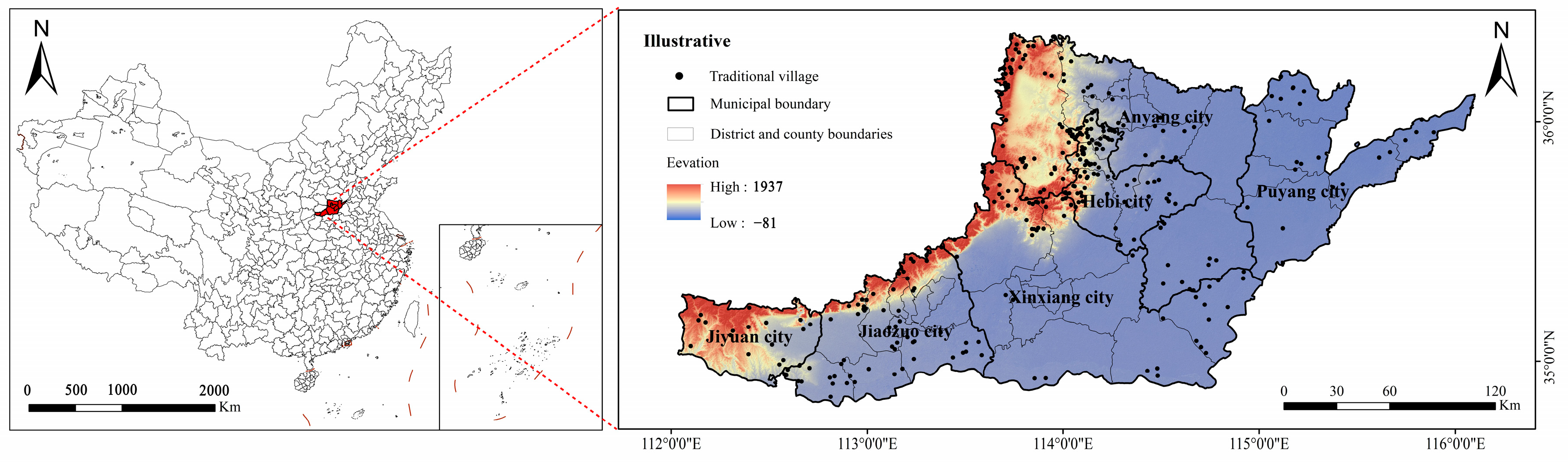
2.1. Regional Overview and Data Sources
2.2. Research Methodology
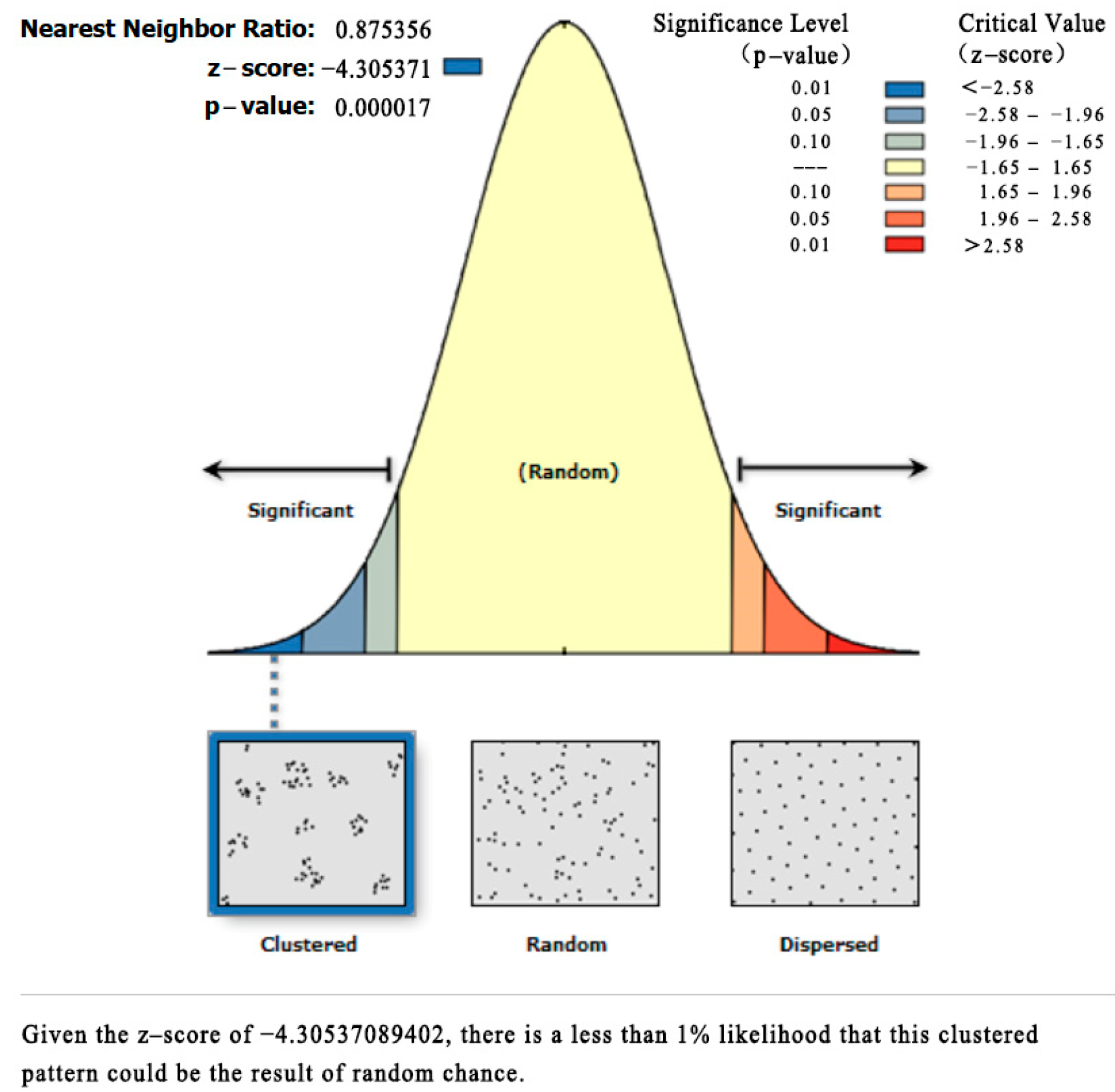
2.2.1. Nearest Neighbor Index
2.2.2. Imbalance Index
2.2.3. Geographic Concentration Index
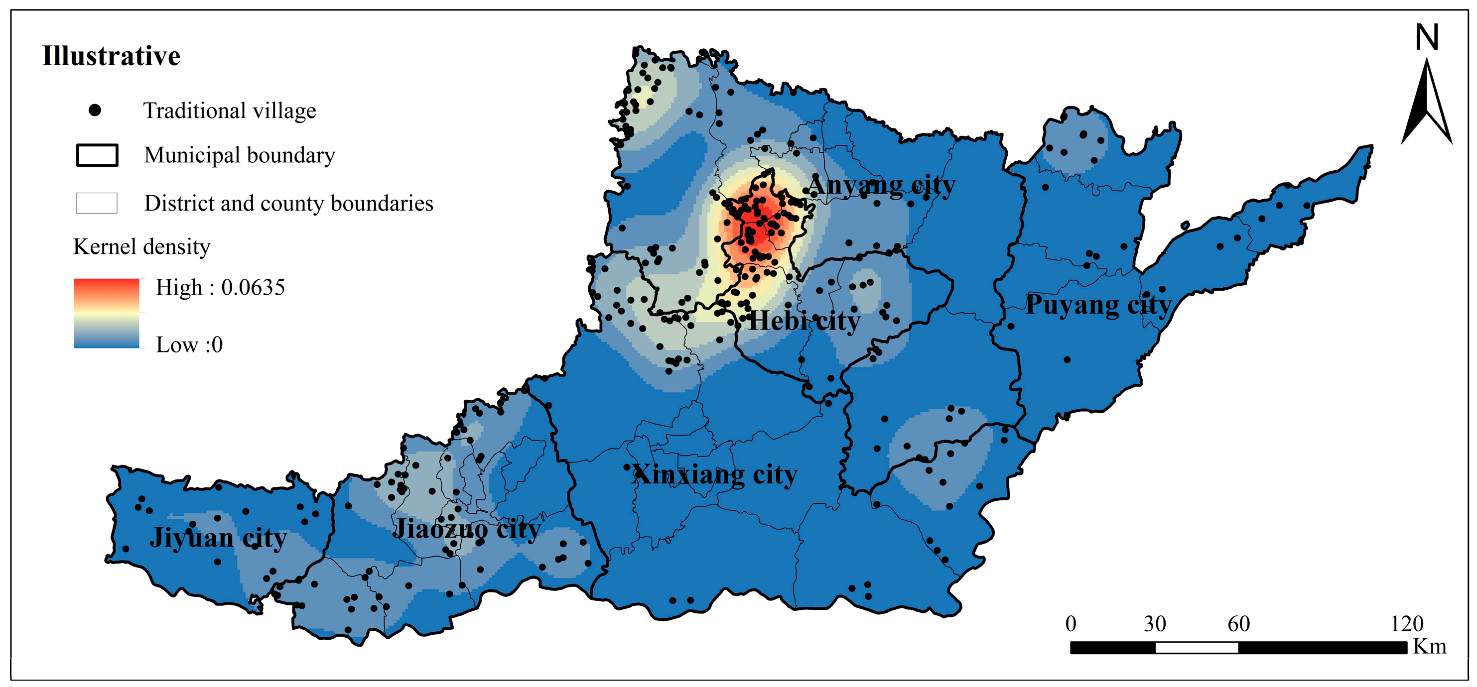
2.2.4. Kernel Density Analysis
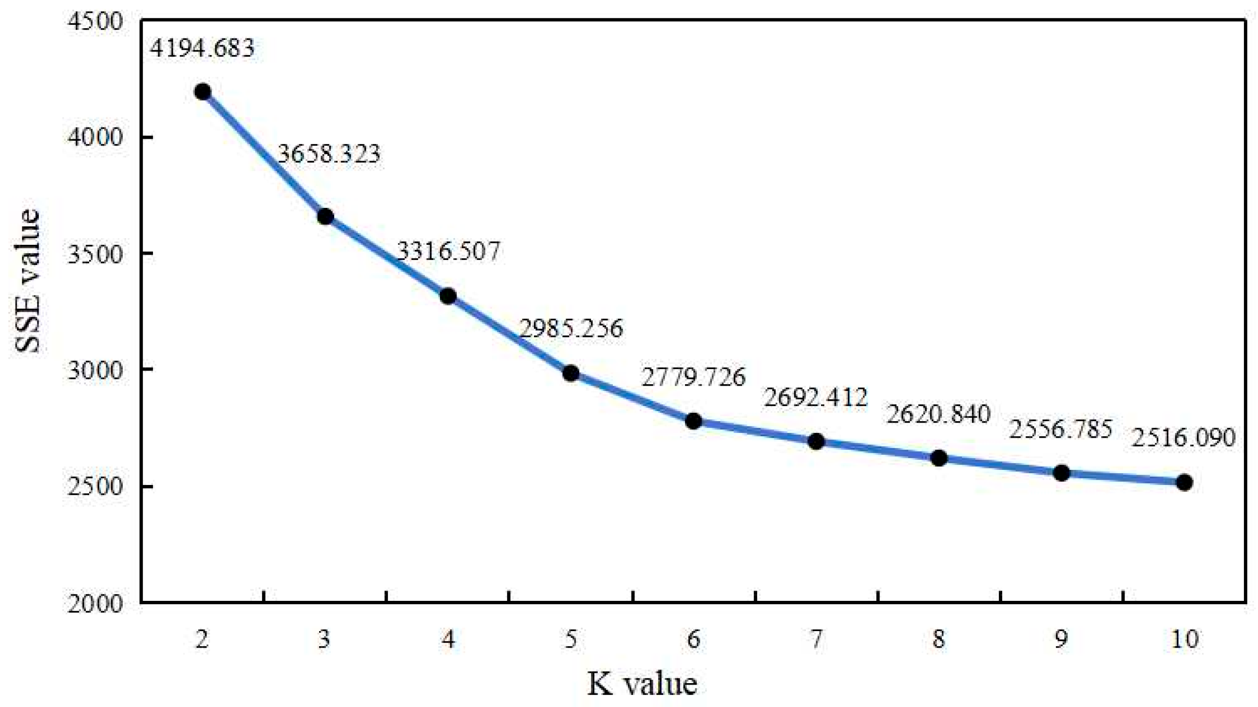
2.2.5. K-Means Clustering Algorithm
3. Results
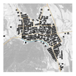
3.1. Spatial Distribution Characteristics of Traditional Villages in Northern Henan
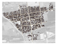
3.1.1. Types of Spatial Distribution
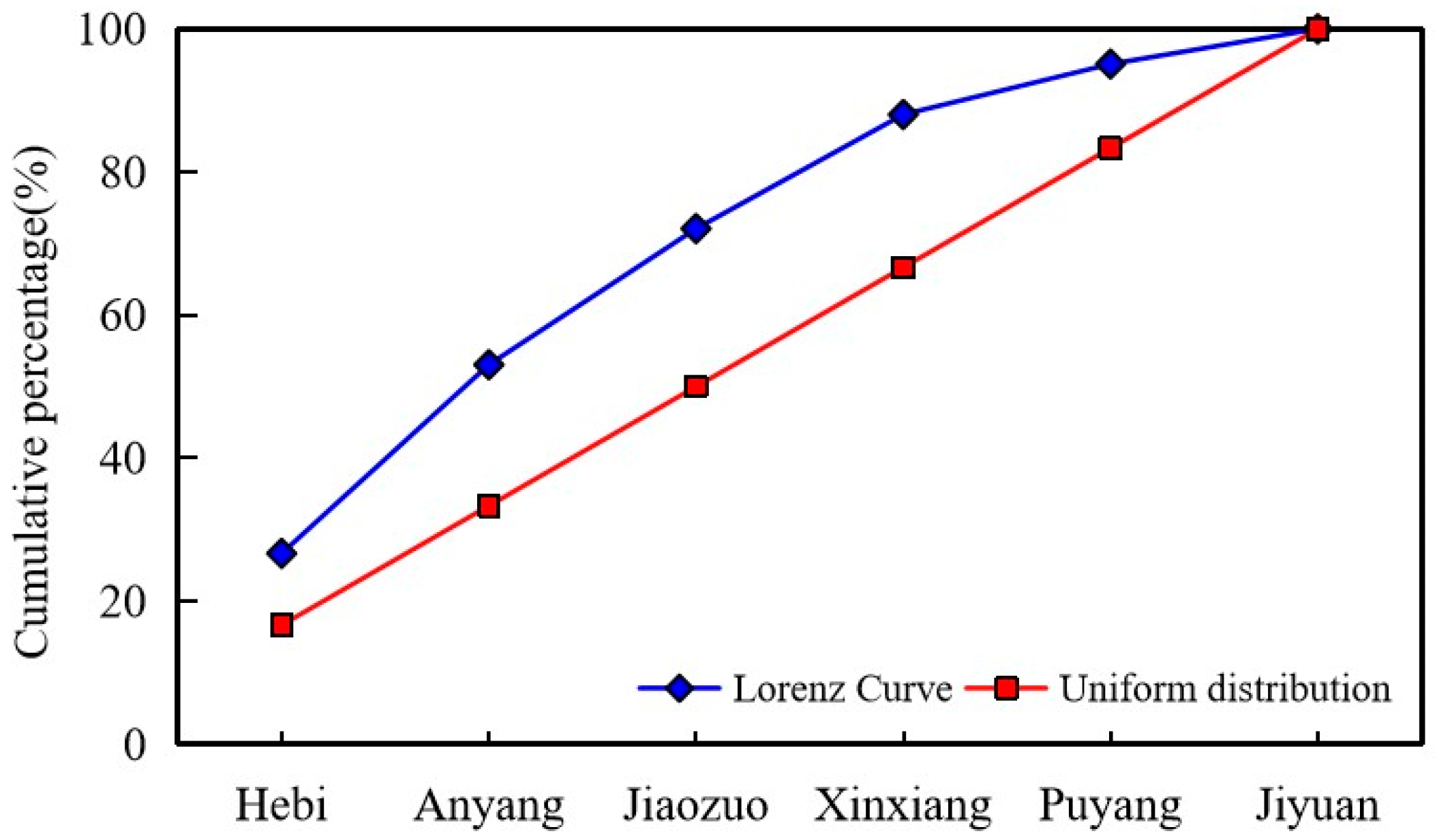
3.1.2. Uniformity of Spatial Distribution
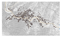
3.1.3. Spatial Distribution Pattern
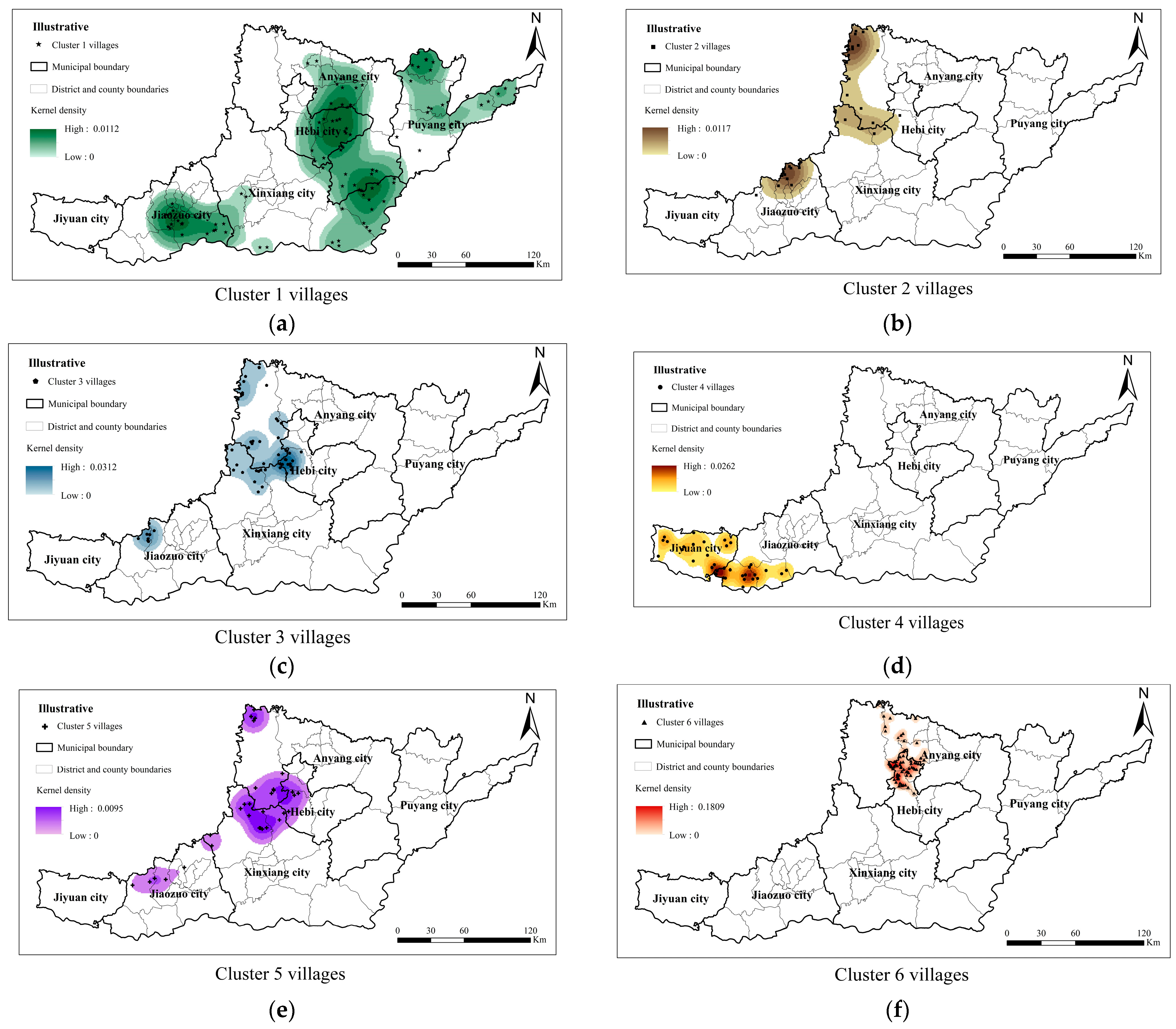
3.2. Traditional Villages in Northern Henan Clustering Zoning
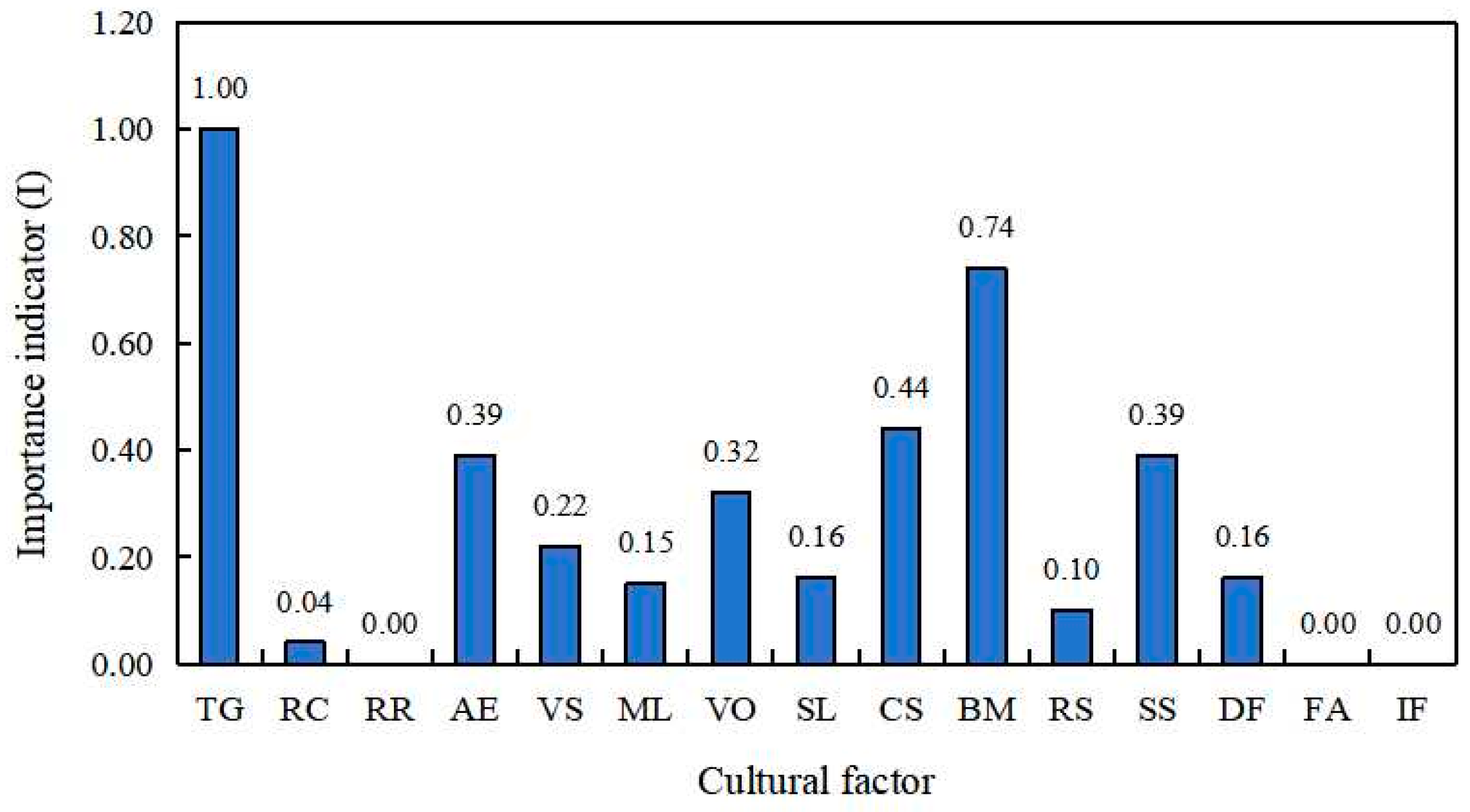
3.2.1. Extraction of Cultural Factors and Indicator System
3.2.2. K-Means Cluster Analysis
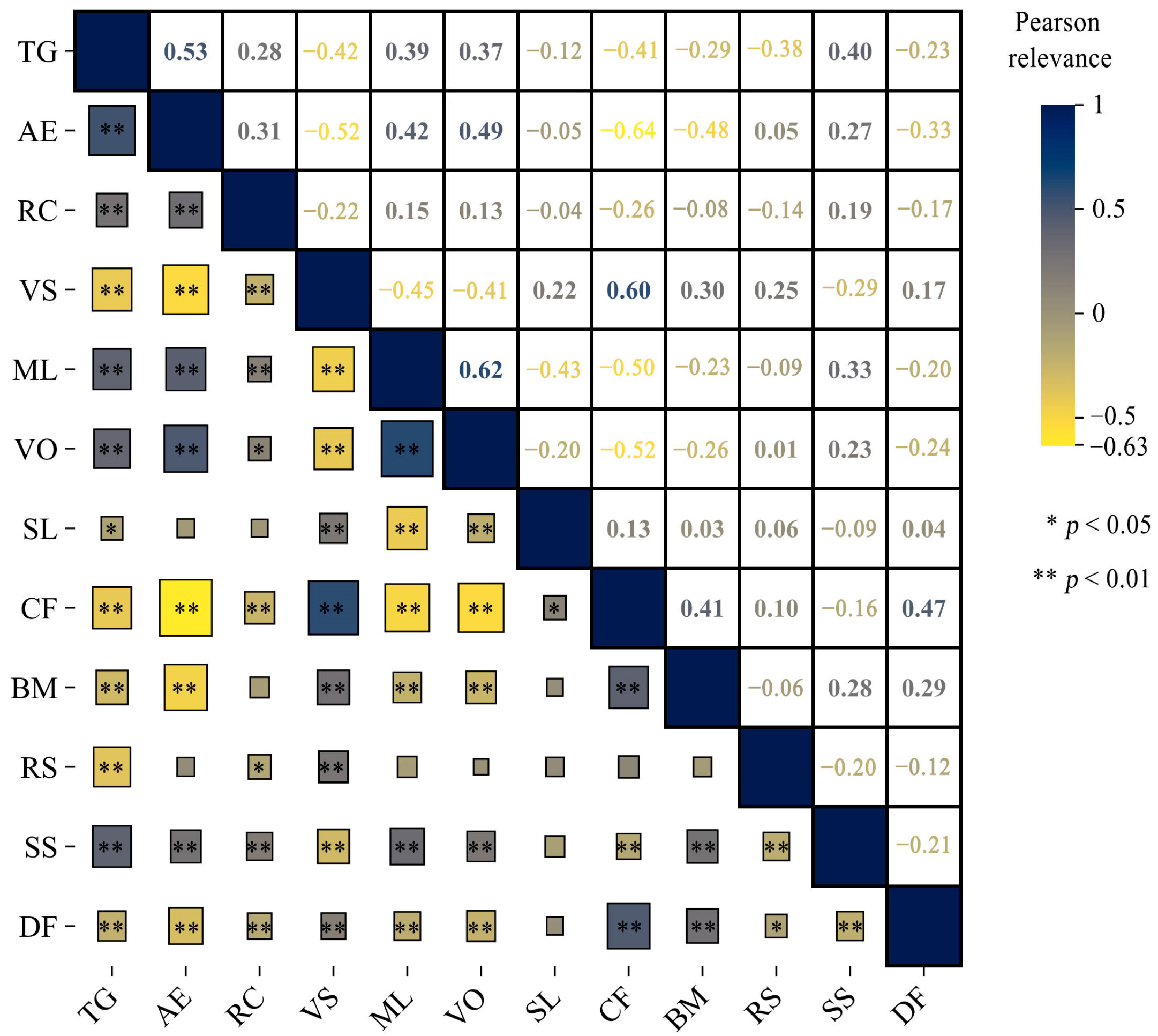
3.2.3. Correlation Analysis of Cultural Factors
4. Discussion
4.1. The Stone Masonry Building Culture Area Along the Taihang Mountains
4.2. The Brick and Stone Mixed Building Culture Area in the Low Hills of the Taihang Mountains
4.3. The Brick and Wood Building Culture Area in the North China Plain
4.4. The Raw Soil Building Culture Area in the Transition Zone of the Loess Plateau
5. Conclusions
Author Contributions
Funding
Institutional Review Board Statement
Informed Consent Statement
Data Availability Statement
Conflicts of Interest
References
- Fuentes, J.M. Methodological bases for documenting and reusing vernacular farm architecture. J. Cult. Herit. 2010, 11, 119–129. [Google Scholar] [CrossRef]
- Philokyprou, M.; Michael, A. Environmental Sustainability in the Conservation of Vernacular Architecture. The Case of Rural and Urban Traditional Settlements in Cyprus. Int. J. Archit. Herit. 2020, 15, 1741–1763. [Google Scholar] [CrossRef]
- Jordan, P.; O’Neill, S. Untangling cultural inheritance: Language diversity and long-house architecture on the Pacific northwest coast. Philos. Trans. R. Soc. B-Biol. Sci. 2010, 365, 3875–3888. [Google Scholar] [CrossRef]
- Rahman, A.A.; Hasshim, S.A.; Rozali, R. Residents’ Preference on Conservation of the Malay Traditional Village in Kampong Morten, Malacca. Procedia Soc. Behav. Sci. 2015, 202, 417–423. [Google Scholar] [CrossRef]
- Gullino, P.; Larcher, F. Integrity in UNESCO World Heritage Sites. A comparative study for rural landscapes. J. Cult. Herit. 2013, 14, 389–395. [Google Scholar] [CrossRef]
- Liu, C.; Cao, Y.J.; Yang, C.; Zhou, Y.; Ai, M. Pattern identification and analysis for the traditional village using low altitude UAV-borne remote sensing: Multifeatured geospatial data to support rural landscape investigation, documentation and management. J. Cult. Herit. 2020, 44, 185–195. [Google Scholar] [CrossRef]
- Monna, F.; Rolland, T.; Denaire, A.; Navarro, N.; Granjon, L.; Barbé, R.; Chateau-Smith, C. Deep learning to detect built cultural heritage from satellite imagery. -Spatial distribution and size of vernacular houses in Sumba, Indonesia. J. Cult. Herit. 2021, 52, 171–183. [Google Scholar] [CrossRef]
- Ruggiero, G.; Parlavecchia, M.; Dal Sasso, P. Typological characterisation and territorial distribution of traditional rural buildings in the Apulian territory (Italy). J. Cult. Herit. 2019, 39, 278–287. [Google Scholar] [CrossRef]
- Kim, G.; Kang, W.; Park, C.R.; Lee, D. Factors of spatial distribution of Korean village groves and relevance to landscape conservation. Landsc. Urban Plan. 2018, 176, 30–37. [Google Scholar] [CrossRef]
- Amraoui, K.; Sriti, L.; Di Turi, S.; Ruggiero, F.; Kaihoul, A. Exploring building’s envelope thermal behavior of the neo-vernacular residential architecture in a hot and dry climate region of Algeria. Build. Simul. 2021, 14, 1567–1584. [Google Scholar] [CrossRef]
- Kubota, T.; Toe, D.H.C.; Ossen, D.R. Field Investigation of Indoor Thermal Environments in Traditional Chinese Shophouses with Courtyards in Malacca. J. Asian Archit. Build. Eng. 2014, 13, 247–254. [Google Scholar] [CrossRef]
- Karahan, F.; Davardoust, S. Evaluation of vernacular architecture of Uzundere District (architectural typology and physical form of building) in relation to ecological sustainable development. J. Asian Archit. Build. Eng. 2020, 19, 490–501. [Google Scholar] [CrossRef]
- Savvides, A.; Michael, A.; Malaktou, E.; Philokyprou, M. Examination and assessment of insolation conditions of streetscapes of traditional settlements in the Eastern Mediterranean area. Habitat Int. 2016, 53, 442–452. [Google Scholar] [CrossRef]
- Li, G.Q.; Chen, B.Q.; Zhu, J.; Sun, L. Traditional Village research based on culture-landscape genes: A Case of Tujia traditional villages in Shizhu, Chongqing, China. J. Asian Archit. Build. Eng. 2023, 23, 325–343. [Google Scholar] [CrossRef]
- Xu, H.; Zhang, T.H.; Ge, B.C.; Song, Y.H. Developing of rural settlement landscape gene research system based on content analysis. J. Asian Archit. Build. Eng. 2023, 22, 2839–2850. [Google Scholar] [CrossRef]
- Altun, S.; Beyhan, G.; Esengil, R. Sustainable rural tourism in Akseki Sarihacilar village. Open House Int. 2007, 32, 98–106. [Google Scholar] [CrossRef]
- Dewi, L.K.Y. Modeling The Relationships Between Tourism Sustainable Factor in the Traditional Village of Pancasari. Procedia Soc. Behav. Sci. 2014, 135, 57–63. [Google Scholar] [CrossRef]
- Kastenholz, E.; Carneiro, M.J.; Marques, C.P.; Lima, J. Understanding and Managing the Rural Tourism Experience—The Case of a Historical Village in Portugal. Tour. Manag. Perspect. 2012, 4, 207–214. [Google Scholar] [CrossRef]
- Lyu, L. Spatial form characteristics and influencing factors of typical traditional villages along the Jiangsu section of the Grand Canal and their implications. Acta Nat. 2024, 39, 1993–2007. [Google Scholar]
- Zhao, Z.; Kong, Y.; Guan, Z.; Liu, Y.; Wang, J. A study of the spatial morphological characteristics and formation mechanisms of villages in river basins: Taking the Yellow River Delta as an example. Urban Plan. 2023, 47, 69–81. [Google Scholar]
- Xiang, Y.; Cao, M.; Yan, F.; Sun, F. Spatio-temporal characteristics of traditional villages in Shaanxi and their protection strategies. Urban Dev. Res. 2019, 26, 27–32. [Google Scholar]
- Li, T.; Zhai, H.; Hu, K. Scenes, Characters, and Spirits: A Study on the Protection of Traditional Villages in Shangri-La from the Perspective of Cultural Landscape. Chin. Gard. 2020, 36, 37–42. [Google Scholar]
- Shi, S.; Liang, J. Traditional villages and tourism: Nostalgia retention and revitalized utilization. Chang. J. 2018, 142–149. [Google Scholar] [CrossRef]
- Sun, R. Evolution of the traditional village tourism development model: Taking the “revival” of Nangang Ancient Pai as an example. J. Guangxi Univ. Natl. (Philos. Soc. Sci. Ed.) 2020, 42, 100–106. [Google Scholar]
- Bao, Y.; Sun, Z.; Song, M.; Li, Z.; Ye, X.; Zang, D. A study of the factors influencing the cultural vitality of the public spaces of traditional villages in Lanxi, Zhejiang Province, from the perspective of residents’ perceptions. Reg. Res. Dev. 2019, 38, 175–180. [Google Scholar]
- Jin, L.; Jiao, S. Research on the structure and formation mechanism of the public space of traditional villages based on graph theory. Planner 2019, 35, 52–57. [Google Scholar]
- Tang, Y.; Wu, J.; Zhang, Y. Spatial distribution characteristics of traditional villages in northern Shaanxi and their influencing factors. Soil Water Conserv. Res. 2023, 30, 396–405. [Google Scholar]
- Zhang, P.; Qu, P.; Yang, N.; Luo, X. A study of the spatial distribution characteristics and influencing factors of traditional villages in Jiangsu Province. Mod. Urban Stud. 2024, 70–77. [Google Scholar] [CrossRef]
- Lin, R.; Yang, F.; Zhang, D.; Zou, C.; Zeng, Z.; Li, X. Extraction of landscape features and zonation of traditional villages in the Minjiang River Basin. South Archit. 2022, 54–60. [Google Scholar] [CrossRef]
- Gao, W.; Xiao, D.; Zhao, Y.; Tao, J.; Zhuo, X. A study of the cultural landscape characteristics and influencing factors of traditional villages in the central Yunnan region. J. Archit. 2023, 194–200. [Google Scholar]
- Hu, Z.; Zheng, W.; Liu, P.; Liu, X. Spatial form and structural characteristics of the genome map of traditional settlement landscapes in Hunan Province. Geogr. J. 2018, 73, 317–332. [Google Scholar]
- Feng, W.; Huang, Z.; Zhang, Y.; Liu, Y.; Pang, M. The beauty of the traditional Dong village landscape in Qiandongnan Prefecture. J. Ecol. 2019, 38, 3820–3830. [Google Scholar]
- Ratzel, F. Anthropogeographie, 1st ed.; Verlag von J. Engelhorns: Stuttgart, Germany, 1892; p. 45. (In German) [Google Scholar]
- Iwata, Y.; Fukamachi, K.; Morimoto, Y. Public perception of the cultural value of satoyama landscape types in Japan. Landsc. Ecol. Eng. 2019, 7, 173–184. [Google Scholar] [CrossRef]
- Aretano, R.; Petrosillo, I.; Zaccarelli, N.; Semeraro, T.; Zurlini, G. People perception of landscape change effects on ecosystem services in small Mediterranean islands: A combination of subjective and objective assessments. Landsc. Urban Plan. 2013, 112, 63–73. [Google Scholar] [CrossRef]
- Canedoli, C.; Bullock, C.; Collier, M.J.; Joyce, D.; Padoa-Schioppa, E. Public participatory mapping of cultural ecosystem services:citizen perception and park management in the Parco Nord of Milan (Italy). Sustainability 2017, 9, 891. [Google Scholar] [CrossRef]
- Kalayci Önac, A.; Birisci, T. Transformation of urban landscape value perception over time: A Delphi technique application. Environ. Monit. Assess. 2019, 191, 741. [Google Scholar] [CrossRef]
- Garcia-martin, M.; Fagerholm, N.; Bieling, C.; Gounaridis, D.; Kizos, T.; Printsmann, A.; Müller, M.; Lieskovský, J.; Plieninger, T. Participatory mapping of landscape values in a Pan-European perspective. Landsc. Ecol. 2017, 32, 2133–2150. [Google Scholar] [CrossRef]
- Sallay, A. Landscape changes andfunction lost landscape values. Appl. Ecol. Environ. Res. 2012, 10, 157–172. [Google Scholar] [CrossRef]
- Baylan, E. Identifying landscapevalues andstakehodler conflictsforthe protectionof landscape multifunctionlity: Thecaseof eksisuwetlands(Turkey). Appl. Ecol. Environ. Res. 2018, 16, 199–223. [Google Scholar] [CrossRef]
- Zscheischler, J.; Busse, M.; Heitepriem, N. Challenges to build up a collaborative landscape management(CLM)—Lessons from a stakeholder analysis in Germany. Environ. Manag. 2019, 64, 580–592. [Google Scholar] [CrossRef]
- Abhishekkumar, K.; Sadhana, C. Survey report on K-means clustering algorithm. Int. J. Mod. Trends Eng. Res. 2017, 4, 218–221. [Google Scholar]
- Jain, A.K. Data clustering: 50 years beyond K-means. Pattern Recognit. Lett. 2010, 31, 651–666. [Google Scholar] [CrossRef]
- Ahmed, M.; Seraj, R.; Islam, S.M.S. The k-means algorithm: A comprehensive survey and performance evaluation. Electronics 2020, 9, 1295. [Google Scholar] [CrossRef]
- Hussain, S.F.; Haris, M. A k-means based co-clustering (kCC) algorithm for sparse, high dimensional data. Expert Syst. Appl. 2019, 118, 20–34. [Google Scholar] [CrossRef]
- Chen, Y.; Zhou, Y. Multifractal study of the spatial structure of the urban system in the northern Henan region. J. Peking Univ. (Nat. Sci. Ed.) 2001, 810–818. [Google Scholar] [CrossRef]
- Feng, Y.; Yu, W.; Lei, R. A study of the spatial distribution characteristics and influencing factors of traditional villages in Guangdong Province. Geoscience 2017, 37, 236–243. [Google Scholar]
- Scott, L.M.; Janikas, M.V. Spatial Statistics in ArcGIS. In Handbook of Applied Spatial Analysis: Software Tools, Methods and Applications; Springer: Berlin/Heidelberg, Germany, 2009; pp. 27–41. [Google Scholar]
- Huang, Z.X. Extensions to the k-means algorithm for clustering large data sets with categorical values. Data Min. Knowl. Discov. 1998, 283–304. [Google Scholar] [CrossRef]
- Chen, Y.; Miao, G. The connotation and elements of cultural landscapes: The ancient tea forest of Jingmai Mountain in Pu’er as an example. Chin. Gard. 2016, 32, 94–98. [Google Scholar]
- Shen, X.; Liu, P.; Deng, Y.; Wang, L. Landscape zoning of traditional settlements in southern China and their utilization value. Geogr. Stud. 2006, 485–494. [Google Scholar]
- Zhou, Z. Regional Studies of Chinese History and Culture, 1st ed.; Fudan University Press: Shanghai, China, 1997; pp. 93–109. [Google Scholar]
- Meng, H. The Doctrine of the Cultural Circle and Cultural Centrism. Northwest Ethn. Stud. 2005, 179–186. [Google Scholar] [CrossRef]
- Zhang, Z.H.; Fang, K.; Wang, X.P.; Chen, L.; Zhang, W.; Furuya, N. Characteristics, correlations of traditional street space elements and tourist density following spontaneous renovation: A case study on Suzhou’s Shantang Street. J. Asian Archit. Build. Eng. 2020, 20, 29–43. [Google Scholar] [CrossRef]


| Level | Cultural Factor | Indicator Properties |
|---|---|---|
| environment | topography and geomorphology (TG) | 1 = plains, 2 = low hills, 3 = mountains (mountain basins, river valleys, valley terraces, mountain slope), 4 = Loess Plateau |
| altitude and elevation (AE) | 1 = AE ≤ 200 m, 2 = 200 < AE ≤ 500 m, 3 = 500 < AE ≤ 800 m, 4 = AE > 800 m | |
| river class (RC) | 1 = class I river, 2 = class II river, 3 = class III river, 4 = class IV river, 5 = class V river, 6 = class VI river | |
| river relationship (RR) | 1 = next to the river: ≤1.5 km from class I II river, ≤1.0 km from class III IV river; ≤0.5 km from class V VI river 2 = near the river: 1.5 km < from class I II river ≤ 3 km, 1.0 km < from class III IV river ≤ 2.5 km; 0.5 km < from class V VI river ≤ 2.0 km 3 = far from river: >3 km from class I II river, >2.5 km from class III IV river; >2 km from class V VI river | |
| village form | village scale (VS) | 1 = VS ≤ 10 ha, 2= 10 < VS ≤ 30 ha, 3 = 30 < VS ≤ 50 ha, 4 = 50 < VS ≤ 70 ha, 5 = VS >70 ha |
| morphological layout (ML) | clustered (1 = row and column of clusters, 2 = compact clusters, 3 = dispersed clusters, 4 = fingerprints), striped (5 = unidirectional strips, 6 = multidirectional strips, 7 = circular strips), scattered (8 = free scattering, 9 = linear scattering) | |
| village orientation (VO) | 1 = sitting north to south (including sitting northeast to southwest and northwest to southeast), 2 = sitting south to north (including sitting southeast to northwest and southwest to northeast), 3 = sitting east to west, 4 = sitting west to east, 5 = multifacing | |
| street layout (SL) | uniaxial (1 = horizontal extension, 2 = vertical lift), multiaxial (3 = multiaxial parallel, 4 = multiaxial convergence, 5 = cross intersection), regular network (6 = orthogonal network, 7 = radial network), irregular network (8 = freely extending, 9 = organic growth) | |
| folk architecture | courtyard form (CF) | 1 = “one”-type, “L”-type, 2 = triple courtyard, 3 = quadruple courtyard, 4 = multiple courtyards, cross courtyards, 5 = kiln house courtyard |
| building materials (BM) | 1 = earth and wood, 2 = stone and wood, 3 = brick and wood, 4 = mixed brick and stone, 5 = brick and earth, mixed earth and stone | |
| roof shape (RS) | 1 = hanging mountain tile surface, 2 = hard mountain back tile surface, 3 = flat roof house, 4 = hoard roof house, 5 = slate surface, 6 = hard mountain combined tile surface | |
| structural system (SS) | 1 = wood frame, 2 = wall, 3 = wood frame stone wall mix, 4 = wood frame arch coupon mix | |
| social cultural | dialectal family (DF) | 1 = shansi dialect hanxin area, 2 = zhongyuan dialect zhengkai area, 3 = zhongyuan dialect luosong area, 4 = zhongyuan dialect yanhe area |
| foundation age (FA) | 1 = Pre-Tang, 2 = Tang, 3 = Song, 4 = Yuan, 5 = Ming, 6 = Qing | |
| traditional industry function (IF) | 1 = agricultural, 2 = forestry and pastoralism, 3 = military defense, 4 = transportation and trade, 5 = political and cultural, 6 = composite |
| Village Name | TG | AE | RC | RR | VS | ML | VO | SL | CF | BM | RS | SS | DF | FA | IF |
|---|---|---|---|---|---|---|---|---|---|---|---|---|---|---|---|
| Yuyang Village | 2 | 1 | 2 | 1 | 4 | 1 | 1 | 7 | 3 | 4 | 2 | 3 | 1 | 1 | 6 |
| Ren Village | 3 | 2 | 5 | 3 | 5 | 1 | 1 | 6 | 2 | 2 | 2 | 2 | 1 | 4 | 6 |
| Chaoyang Village | 3 | 4 | 6 | 2 | 1 | 2 | 5 | 8 | 1 | 2 | 5 | 2 | 1 | 5 | 2 |
| Caomiao Village | 3 | 3 | 6 | 1 | 1 | 5 | 4 | 1 | 1 | 2 | 5 | 2 | 1 | 5 | 1 |
| Nanjie Village | 1 | 1 | 2 | 1 | 2 | 1 | 1 | 6 | 4 | 3 | 6 | 1 | 2 | 3 | 4 |
| Dahu Village | 2 | 1 | 6 | 1 | 2 | 1 | 1 | 1 | 3 | 4 | 3 | 3 | 1 | 5 | 6 |
| Feiquan Village | 2 | 1 | 6 | 3 | 2 | 4 | 1 | 9 | 3 | 4 | 3 | 3 | 1 | 6 | 6 |
| Wenpo Village | 3 | 2 | 6 | 3 | 1 | 5 | 1 | 1 | 1 | 2 | 2 | 2 | 1 | 6 | 2 |
| Zhengchang Village | 1 | 1 | 5 | 2 | 4 | 1 | 1 | 6 | 4 | 3 | 6 | 1 | 2 | 5 | 1 |
| Beizhu Village | 1 | 1 | 5 | 2 | 4 | 1 | 1 | 6 | 4 | 3 | 6 | 1 | 1 | 2 | 1 |
| Shuangmiao Village | 3 | 4 | 6 | 3 | 2 | 2 | 1 | 8 | 1 | 2 | 4 | 2 | 1 | 2 | 2 |
| Mogou Village | 4 | 1 | 6 | 1 | 2 | 4 | 1 | 3 | 5 | 5 | 1 | 4 | 3 | 4 | 1 |
| Duan Village | 4 | 1 | 5 | 3 | 3 | 1 | 1 | 6 | 3 | 5 | 1 | 1 | 1 | 1 | 1 |
| Liyu Village | 3 | 2 | 6 | 1 | 2 | 7 | 5 | 1 | 1 | 2 | 2 | 2 | 1 | 5 | 1 |
| Pingdian Village | 3 | 3 | 4 | 1 | 2 | 2 | 1 | 1 | 2 | 2 | 2 | 2 | 1 | 5 | 4 |
| Dache Village | 1 | 1 | 2 | 2 | 5 | 2 | 1 | 6 | 4 | 3 | 6 | 1 | 2 | 6 | 1 |
| Danguai Village | 1 | 1 | 5 | 3 | 5 | 1 | 1 | 6 | 4 | 3 | 2 | 1 | 2 | 5 | 1 |
| Wanglou Village | 1 | 1 | 2 | 3 | 2 | 2 | 1 | 9 | 3 | 3 | 2 | 1 | 4 | 5 | 1 |
| Shuangfang Village | 4 | 2 | 6 | 1 | 1 | 5 | 1 | 1 | 1 | 1 | 1 | 1 | 1 | 5 | 2 |
| Zhanghe Village | 4 | 2 | 5 | 1 | 1 | 2 | 3 | 8 | 1 | 1 | 1 | 1 | 1 | 5 | 1 |
| Cultural Factor | Clustering Category Variance (Mean ± Standard Deviation) | F | p | |||||
|---|---|---|---|---|---|---|---|---|
| Cluster 1 | Cluster 2 | Cluster 3 | Cluster 4 | Cluster 5 | Cluster 6 | |||
| TG | 1.00 ± 0.00 | 3.00 ± 0.00 | 2.94 ± 0.41 | 4.00 ± 0.00 | 3.26 ± 0.49 | 2.00 ± 0.00 | 910.886 | 0.000 ** |
| RC | 4.00 ± 1.38 | 5.24 ± 0.55 | 4.91 ± 1.06 | 4.84 ± 1.01 | 4.58 ± 1.16 | 4.57 ± 1.09 | 8.677 | 0.000 ** |
| RR | 2.03 ± 0.78 | 2.38 ± 0.82 | 1.99 ± 0.84 | 2.26 ± 0.81 | 2.07 ± 0.83 | 1.98 ± 0.85 | 1.539 | 0.177 |
| AE | 1.00 ± 0.00 | 3.21 ± 0.69 | 2.30 ± 0.73 | 1.21 ± 0.42 | 1.84 ± 0.53 | 1.48 ± 0.50 | 123.444 | 0.000 ** |
| VS | 1.00 ± 0.00 | 3.21 ± 1.61 | 3.86 ± 1.63 | 1.42 ± 1.26 | 1.33 ± 0.94 | 1.77 ± 1.50 | 57.044 | 0.000 ** |
| ML | 3.40 ± 1.22 | 1.32 ± 0.53 | 1.53 ± 0.65 | 2.95 ± 1.31 | 2.37 ± 1.29 | 2.61 ± 1.08 | 35.744 | 0.000 ** |
| VO | 1.40 ± 0.77 | 3.03 ± 1.82 | 6.10 ± 1.60 | 2.26 ± 1.69 | 2.07 ± 1.39 | 2.74 ± 1.74 | 95.048 | 0.000 ** |
| SL | 5.88 ± 1.65 | 7.68 ± 1.47 | 2.64 ± 2.23 | 5.11 ± 1.33 | 6.51 ± 2.41 | 5.70 ± 2.51 | 37.928 | 0.000 ** |
| CS | 3.40 ± 0.49 | 1.12 ± 0.33 | 1.19 ± 0.39 | 3.89 ± 0.99 | 2.33 ± 1.13 | 2.25 ± 0.54 | 153.054 | 0.000 ** |
| BM | 3.00 ± 0.00 | 2.00 ± 0.00 | 2.17 ± 0.70 | 5.00 ± 0.00 | 1.72 ± 0.45 | 4.00 ± 0.00 | 424.230 | 0.000 ** |
| RS | 3.62 ± 1.97 | 3.88 ± 1.23 | 2.79 ± 1.23 | 1.00 ± 0.00 | 1.95 ± 0.87 | 2.75 ± 0.43 | 21.324 | 0.000 ** |
| SS | 1.00 ± 0.00 | 2.00 ± 0.00 | 2.06 ± 0.41 | 2.26 ± 1.52 | 2.07 ± 0.80 | 3.00 ± 0.00 | 127.352 | 0.000 ** |
| DF | 1.71 ± 0.84 | 1.00 ± 0.00 | 1.00 ± 0.00 | 2.26 ± 0.99 | 1.00 ± 0.00 | 1.00 ± 0.00 | 39.137 | 0.000 ** |
| FA | 4.35 ± 1.50 | 4.88 ± 1.07 | 4.31 ± 1.74 | 3.84 ± 1.74 | 4.00 ± 1.81 | 4.13 ± 1.77 | 1.608 | 0.158 |
| IF | 2.62 ± 2.02 | 2.03 ± 0.94 | 2.16 ± 1.16 | 2.21 ± 1.96 | 2.47 ± 1.86 | 2.67 ± 2.08 | 1.198 | 0.310 |
| Cultural Factor | TG | AE | RC | VS | ML | VO | SL | CF | BM | RS | SS | DF | |
|---|---|---|---|---|---|---|---|---|---|---|---|---|---|
| TG | Pearson relevance | 1 | |||||||||||
| p (salience) | - | ||||||||||||
| AE | Pearson relevance | 0.531 ** | 1 | ||||||||||
| p (salience) | 0.000 | - | |||||||||||
| RC | Pearson relevance | 0.276 ** | 0.312 ** | 1 | |||||||||
| p (salience) | 0.000 | 0.000 | - | ||||||||||
| VS | Pearson relevance | −0.422 ** | −0.524 ** | −0.220 ** | 1 | ||||||||
| p (salience) | 0.000 | 0.000 | 0.000 | - | |||||||||
| ML | Pearson relevance | 0.393 ** | 0.425 ** | 0.150 ** | −0.452 ** | 1 | |||||||
| p (salience) | 0.000 | 0.000 | 0.007 | 0.000 | - | ||||||||
| VO | Pearson relevance | 0.367 ** | 0.488 ** | 0.132 * | −0.408 ** | 0.622 ** | 1 | ||||||
| p (salience) | 0.000 | 0.000 | 0.017 | 0.000 | 0.000 | - | |||||||
| SL | Pearson relevance | −0.123 * | −0.051 | −0.036 | 0.223 ** | −0.428 ** | −0.205 ** | 1 | |||||
| p (salience) | 0.026 | 0.357 | 0.512 | 0.000 | 0.000 | 0.000 | - | ||||||
| CF | Pearson relevance | −0.410 ** | −0.635 ** | −0.260 ** | 0.596 ** | −0.503 ** | −0.521 ** | 0.134 * | 1 | ||||
| p (salience) | 0.000 | 0.000 | 0.000 | 0.000 | 0.000 | 0.000 | 0.016 | - | |||||
| BM | Pearson relevance | −0.292 ** | −0.476 ** | −0.082 | 0.296 ** | −0.234 ** | −0.263 ** | 0.033 | 0.413 ** | 1 | |||
| p (salience) | 0.000 | 0.000 | 0.140 | 0.000 | 0.000 | 0.000 | 0.557 | 0.000 | - | ||||
| RS | Pearson relevance | −0.378 ** | 0.053 | −0.140 * | 0.251 ** | −0.085 | 0.010 | 0.059 | 0.102 | −0.064 | 1 | ||
| p (salience) | 0.000 | 0.340 | 0.011 | 0.000 | 0.124 | 0.858 | 0.290 | 0.065 | 0.246 | - | |||
| SS | Pearson relevance | 0.404 ** | 0.269 ** | 0.194 ** | −0.292 ** | 0.329 ** | 0.231 ** | −0.088 | −0.161 ** | 0.276 ** | −0.199 ** | 1 | |
| p (salience) | 0.000 | 0.000 | 0.000 | 0.000 | 0.000 | 0.000 | 0.111 | 0.004 | 0.000 | 0.000 | - | ||
| DF | Pearson relevance | −0.226 ** | −0.326 ** | −0.165 ** | 0.168 ** | −0.202 ** | −0.237 ** | 0.038 | 0.468 ** | 0.291 ** | −0.121 * | −0.211 ** | 1 |
| p (salience) | 0.000 | 0.000 | 0.003 | 0.002 | 0.000 | 0.000 | 0.497 | 0.000 | 0.000 | 0.029 | 0.000 | - | |
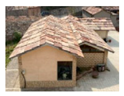
| Main Cultural Landscape | (a) The Stone Masonry Building Culture Area Along the Taihang Mountains | (b) The Brick and Stone Mixed Building Culture Area in the Low Hills of the Taihang Mountains | (c) The Brick and Wood Building Culture Area in the North China Plain | (d) The Raw Soil Building Culture Area in the Transition Zone of the Loess Plateau | |||
|---|---|---|---|---|---|---|---|
| topography and geomorphology | mountains | low hills | plains | Loess Plateau | |||
| building materials | 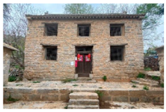 | 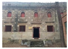 | 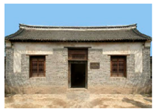 | 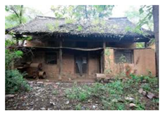 | |||
| stone, wood | mixed brick, stone and wood | green brick, wood | raw earth, wood | ||||
| courtyard system | “one”-type, “L”-type | triple courtyard, quadruple courtyard | quadruple courtyard, multiple courtyards, cross courtyards | triple courtyard, kiln house courtyard | |||
 |  |  |  |  |  | ||
| “one”-type “L”-type | triple courtyard | quadruple courtyard | multiple courtyards | cross courtyards | kiln house courtyard | ||
| structural system | 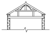 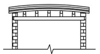 | 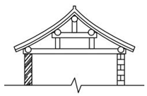 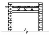 | 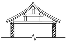 |  | |||
| wall | wood frame stone wall mix | wood frame | wood frame (same as above), arch coupon | ||||
| roof shape | 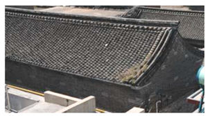 | 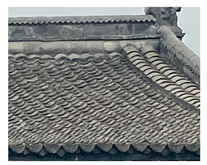 | 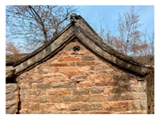 | 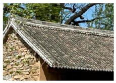 | |||
| hard mountain back tile surface (coexistence type) | hanging mountain tile surface | ||||||
 slate surface | 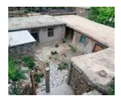 hoard roof house | 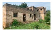 flat roof house |  hard mountain combined tile surface | 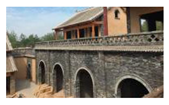 roof of a kiln | |||
| morphological layout | compact clusters, striped | compact clusters, striped | row and column of clusters, fingerprints | row and column of clusters, striped | |||
 |  |  |  | ||||
| compact clusters | striped | row and column | fingerprints | ||||
| of clusters | |||||||
| typical village | Huanghou Village, Pingdingyao Village | Feiquan Village, Dahu Village | Danguai Village, Yuyang Village | Shuangfang Village, Mogou Village | |||
Disclaimer/Publisher’s Note: The statements, opinions and data contained in all publications are solely those of the individual author(s) and contributor(s) and not of MDPI and/or the editor(s). MDPI and/or the editor(s) disclaim responsibility for any injury to people or property resulting from any ideas, methods, instructions or products referred to in the content. |
© 2025 by the authors. Licensee MDPI, Basel, Switzerland. This article is an open access article distributed under the terms and conditions of the Creative Commons Attribution (CC BY) license (https://creativecommons.org/licenses/by/4.0/).
Share and Cite
Mao, Y.; Zhang, Z.; Sun, C.; Cai, M.; Ge, Y. Study on the Distribution Characteristics and Cultural Landscape Zoning of Traditional Villages in North Henan Province. Sustainability 2025, 17, 5254. https://doi.org/10.3390/su17125254
Mao Y, Zhang Z, Sun C, Cai M, Ge Y. Study on the Distribution Characteristics and Cultural Landscape Zoning of Traditional Villages in North Henan Province. Sustainability. 2025; 17(12):5254. https://doi.org/10.3390/su17125254
Chicago/Turabian StyleMao, Yalong, Zihao Zhang, Chang Sun, Minjun Cai, and Yipeng Ge. 2025. "Study on the Distribution Characteristics and Cultural Landscape Zoning of Traditional Villages in North Henan Province" Sustainability 17, no. 12: 5254. https://doi.org/10.3390/su17125254
APA StyleMao, Y., Zhang, Z., Sun, C., Cai, M., & Ge, Y. (2025). Study on the Distribution Characteristics and Cultural Landscape Zoning of Traditional Villages in North Henan Province. Sustainability, 17(12), 5254. https://doi.org/10.3390/su17125254