Article

Legal Loopholes and Investment Pressure in the Development of Individual Recreational Buildings in Protected Landscapes

Institute of Spatial Management, Wrocław University of Environmental and Life Sciences, ul. Grunwaldzka 55, 50-357 Wrocław, Poland
*
Author to whom correspondence should be addressed.
Sustainability 2025, 17(10), 4659; https://doi.org/10.3390/su17104659
Submission received: 28 March 2025 / Revised: 27 April 2025 / Accepted: 16 May 2025 / Published: 19 May 2025

Abstract

:
This study investigates the legal and planning risks related to the implementation of individual recreational buildings in environmentally valuable areas, with particular emphasis on the municipality of Bukowina Tatrzańska in southern Poland. This research highlights the consequences of a legal loophole that allows construction in protected landscapes based solely on a notification procedure, often excluding municipal authorities from the decision-making process. This analysis combines field inventory, planning document review, and interviews with local officials to assess the scale and nature of development in areas lacking valid local development plans. The findings reveal increasing investor pressure and the misuse of individual recreational buildings for commercial purposes, leading to spatial and landscape degradation. Despite formal compliance with certain legal provisions, construction often takes place in areas of high natural and scenic value, undermining spatial order. This study recommends strengthening local planning instruments, revising construction laws, and enhancing investment control to ensure sustainable land use and landscape protection.

1. Introduction

The literature emphasizes that spatial planning plays a key role in ensuring spatial order and promoting sustainable development [1]. According to Article 2(1) of the Spatial Planning and Development Act [2], in Poland, spatial order refers to an organized arrangement of space that forms a harmonious whole, taking into account functional, socio-economic, environmental, cultural, as well as compositional and esthetic conditions, based on clearly defined interrelations. Polish legislation further requires that spatial order—along with urban and architectural planning principles—be integrated into all spatial planning and development activities. These principles are essential to public interest and are significantly influenced by the planning policies adopted by local authorities, particularly through the development and implementation of local spatial plans in previous years [3].
In turn, any construction activities in particular spaces cause certain effects in the landscape; therefore it has to be subject to an ongoing control aimed at eliminating or reducing the growing conflicts and risks [4]. According to Raszeja E. [4] and Böhm A. [5], spatial planning constitutes such a special form of activity focused on achieving spatial order and preserving the specificity of the landscape if equipped with appropriate, legally mandated instruments, which should be properly used to protect and shape the landscape.
Individual recreational buildings, understood as structures intended for periodic leisure use, are currently spreading into environmentally and scenically valuable areas across Poland, including mountainous and coastal regions. Also referred to as summer houses, these architectural objects are designed for recreational purposes and may have a building footprint of up to 70 m2. Investors frequently exploit legal loopholes to construct such buildings within protected landscapes, often exceeding the permitted development parameters. This phenomenon is not unique to Poland and reflects a broader challenge in spatial governance faced by many countries.
Landscape scenery, landscape character, and all that people perceive as landscape depends partly on natural conditions like topography, geology, soil, climate, hydrography, natural habitats, and partly on human activities [6]. As a result of anthropogenic changes, the following changes occur in foothill areas:
  • Loss of pastures [7] e.g., disappearance of grazing animals; increase in meadows;
  • Decrease in land use types of rural landscape [8,9] e.g., vineyards, orchards, gardens, and arable land;
  • Habitat rehabilitation sites, e.g., increase in semi-natural vegetation and wetlands;
  • Transformation of touristic sites [10,11] e.g., ski resorts; mass and rural tourism;
  • Increase in built-up land and development of built linear infrastructure [12,13,14] e.g., sprawling settlements, logistical and commercial sites, railways, and transport [6].
In Switzerland, the efficient expansion of built-up areas and the conservation of agricultural land are considered priorities of the planning system, as space is a limited resource [15,16]. According to Romano B. et al. [17], building illegality is hidden in several forms: it does not necessarily correspond to low-quality buildings; it is not only blatantly located in the most attractive places for tourism; it is not only practiced by individual citizens, but also by companies with few scruples. In Italy, unauthorized building is a very common phenomenon [18]. The topic of unauthorized development in the south of Italy has been researched by, among others, Zanfi [19], Petrella and de Biase [18], and Romano et al. [17]. They start by assessing the main positions that have informed the debate since the 1960s and evaluate the consequences of the condono edilizio (building amnesty) policy in light of the impact that illegal construction has had on the landscape in urban, rural, and coastal areas.
The problem with the preservation and continuation of landscaping traditions, and their transfer to future generations recently gained momentum after the notorious boom of unsanctioned building work in Curonian Spit National Park (Lithuania) and other territories marked as cultural landscapes [20]. Burksiene and Dvorak [21] wrote about management in areas protected by countries with newer democracies and the involvement of residents in landscape protection in Lithuania. Unauthorized building is quite frequent in Lithuania and in Russia. In Russia more recently, the matter of unauthorized construction has drawn the attention of many scientists. And working on the subject, field-specific studies on unauthorized construction have been taken into account [22].
The activity and well-thought-out policy implemented by the municipality in the development of local plans allows the introduction of legal provisions covering the area of planning in terms of arrangements for development and land use, including, for example, the site function, parameters and indicators of development and land use, among other things. At the same time, the legally binding local plan rules out the possibility of issuing a decision on zoning conditions or a decision on the location of a public purpose investment. An extensive debate addressing the indicated decisions is currently underway in Poland.
The aim of this study is to identify and analyze the consequences of a legal loophole in Polish construction law that enables the development of individual recreational buildings in protected landscape areas without comprehensive spatial planning oversight. By examining the spatial and legal context of investments carried out through the simplified notification procedure—particularly in the absence of valid local development plans—this research highlights the mechanisms by which investor-driven pressure exploits regulatory gaps, bypasses municipal control, and contributes to landscape degradation. This study focuses on the municipality of Bukowina Tatrzańska as a case study area to evaluate planning practices, legal limitations, and the implications for sustainable landscape management.

2. Theoretical Framework

This article analyzes a legal loophole in construction law regulations that permits the development of individual recreational structures in protected areas with high landscape value. This gap in the legal framework has led to the construction of buildings in areas excluded from development, which are subject to protection, thereby contributing to landscape degradation. The expansion of recreational development is influenced by investor pressure, with buildings often constructed in clusters not for personal recreational use, but rather with the intention of conducting commercial service activities.
The provisions contained in the Spatial Planning and Development Act of 27 March 2003 [2], constitute the key legal regulation in Poland, the content of which determines, in particular, the possibility of land use and development. The recently introduced amendments under the Act of 7 July 2023, amending the Spatial Planning and Development and certain other laws [23], refer to systemic changes, simultaneously removing some of the well-known forms of planning documents, introducing the new ones, and significantly changing the legal regulation of the other forms. The transitional provisions which regulate the legal force of the existing and new forms of urban planning and the effects of numerous amendments made to the laws previously in force are of crucial importance. Currently, in Poland we are facing a situation where different municipalities follow various rules for enacting planning acts and issuing decisions regarding spatial planning (primarily administrative decisions on zoning and land use conditions). The situation is quite complicated and hinders the protection of spatial order and the promotion of sustainable development.
While sustainable development is well defined and known worldwide, spatial order is a term specific to Poland. The term is related to sustainable development as well as landscape protection [24]. Lechowska [25], claims that sustainable development shaping is strongly linked to spatial order shaping. Kozłowski [26], pointed out that a harmonious landscape can be a sign of spatial order. However, a lack of spatial order is common in Poland. The Spatial Planning and Development Act [2] provides a definition of spatial order; this definition is inaccurate [24,27,28] and it does not give any technical guidelines that could be helpful for spatial order evaluation. To solve this issue, many researchers have proposed their own spatial order definitions, as well as various methods of its evaluation.
The local development plan specifies land use, the location of public purpose investments, and determines the manner of development and zoning conditions (Art. 4.1 of the Spatial Planning and Development Act) [2]. The local plan used to be a tool for the implementation of the spatial policy presented in the Study (the Study of land use conditions and directions in the spatial planning system of the municipality) and currently is to be consistent with the findings of the general plan. The local plan, unlike the Study, constitutes the act of local law—a legal provision that applies to the area for which it was adopted. It is equally binding for local government representatives, officials, and citizens. The development of a local plan is obligatory in only a few situations, which means that in Poland there is still a considerable number of areas without a valid local plan.
Faced with the repeal of the old general plans (drawn up before 1 January 1995), the legislator allowed, in 2003, a temporary system for carrying out investments on the basis of zoning decisions and land use conditions. Invariably, it is the local development plan which is the basic spatial planning act in matters concerning the location of development and land use. A zoning decision introduced at that time provides for the manner and conditions of land development only if the area is not covered by a local plan. These decisions do not have to comply with the spatial policy set forth in the Study, as they are not legally binding. In some municipalities, it resulted in spatial chaos, which is currently difficult to handle. In the areas excluded from development in the municipality spatial policy, the decisions on zoning conditions were issued and followed by the realization of investments, which were later difficult to legalize without amending (updating) the Study. This was the case because the local planning arrangements had to be consistent with the findings of the Study. Taking into account the transitional provisions, the findings of the Study will be taken into consideration regarding the proceedings initiated for the purposes of local planning on the date prior to amending the regulations (the amendment took effect on 24 September 2024), but after the “new” municipal general plan comes into force—the arrangements of the latter plan.
The decisions on zoning conditions are issued when several conditions specified in Art. 61.1 of the Spatial Planning and Development Act [23] are met simultaneously. The interpretation of these conditions—quite strict at first—was moderated in the subsequent years. As a result of legal interpretations, decisions by the local government board of appeals, court rulings and, eventually, changes in regulations, the liberalization of law in this regard has been observed. The first condition, which states that “at least one neighboring plot, accessible from the same public road, is developed in a way that allows determining the requirements for a new development regarding the continuation of parameters, features and indicators for development and land use, including the dimensions and architectural form of buildings, building lines and the intensity of land use” is already met if the development takes place in the analyzed area and not in the immediate vicinity.
The analyzed area is designated at a distance equal three times the width of the plot front (the area applied for), however, no less than 50 m and, as added after the amendment of the regulations, no more than 200 m (the limitation of the analyzed area refers to single-family residential buildings of a building area up to 70 m2). Needless to say, the previous lack of restrictions caused investors to include their neighbors’ properties in the application to increase the width of the plot front which, in turn, allowed expanding the analyzed area and, consequently, opened the possibility to carry out a new development at a considerable distance from the existing development.
The progressive landscape degradation was one of the motives for amending the regulatory provisions regarding the possibility of issuing the aforementioned decisions based on the Study. The legislator allowed such a form of investment realization basis to continue no longer than until the end of 2025. However, if the municipal general plan is adopted, it will become the basis for issuing decisions in the absence of a local plan, and only in the areas designated as the “complementary development” ones. In addition, the zoning conditions issued after 31 December 2025 will expire 5 years after they were granted. The project proponent points out that this period of time is sufficient to take the necessary steps aimed at the investment realization. Currently, investors are racing against time to obtain zoning decisions before the general plan is adopted in municipalities, as such a plan may block, for a long time, the possibility of investment realization for various reasons (e.g., based on demographic analysis, significant costs for the realization of social and technical infrastructure facilities, site location, among other things). This is because the provisions of the introduced “new” general plan will be binding for local plans and for zoning decisions.
A significant problem contributing to the degradation of landscapes, especially the areas of scenic value was the possibility of a development realization based on a notification provided by the regulations in Poland, e.g., in relation to individual recreation buildings (the procedure is regulated by the provisions of the Construction Law) [29]. A certain procedural ambiguity, in the period 2020–2023, meant that some architectural and construction administration bodies did not require the investment compliance with the zoning decision, or even the decision itself (this applies to the areas without a valid local plan) [30]. During this period, the possibility of erecting individual recreation buildings with development areas of up to 35 m2 based on a notification filed to a construction administration body without the zoning decision requirements was particularly detrimental to landscape protection. The amendment to the provisions of the Construction Law, which came into effect at that time influenced further spatial development outside the areas designated in the Study of land use conditions and directions in the spatial planning system of the municipality. Investors took advantage of this opportunity, usually constructing several individual recreation buildings at the same time, which they later allocated for renting. In this way, investing in protected and environmentally valuable areas was frequently realized without establishing the land use and development conditions specified in the zoning decision.

3. Materials and Methods

3.1. Study Area

In order to achieve the purpose of this study, the conducted analysis covered the investments realized in the area of the Bukowina Tatrzańska municipality, in Tatra County, in Małopolskie Voivodeship, despite the decisions refusing to issue a zoning decision (Figure 1). The municipality is located in protected areas due to their high natural value. Tatra National Park (TNP) was established in the southern part of the Bukowina Tatrzańska municipality. In addition, within the borders of the municipality, the area of Natura 2000 has been created: “Białka Valley” PLH120024. The rest of the municipality area is located in the South Małopolska Protected Landscape Area, established in 1 January 1997 by the resolution of the Voivode of Nowy Sącz, amended several times in the following years [31], functioning pursuant to the Resolution No. XX/274/20 of the Małopolskie Voivodship Parliament dated 27 April 2020 (Journal of Laws of the Małopolskie Voivodship of 22 May 2020, no. 3482 [32]. The protected landscape area covers attractive landscapes featuring different types of ecosystems and was established to ensure ecological balance in the natural environment, sustainability of ecosystems, and to increase biodiversity.
Tourism and recreation constitute the main functions of the municipality. Currently, agriculture plays a marginal role. A relatively high degree of anthropopressure is observed in the municipality. Among the developments in the villages of Białka Tatrzańska and Bukowina Tatrzańska, the dominating ones are guesthouse facilities and large-scale residential houses, while the areas suitable for ski runs are occupied by ski stations expanding their offer of ski lifts and chairlifts. Ski lifts and cable cars operate on the slopes of Białczańskie hills, in the area of Wierch Olczański (Olczański Peak) and Wierch Rusiński in Bukowina Tatrzańska, and along the national road towards the border crossing with Slovakia in Jurgów and in the area of Wierch Litwiński and Koziniec in Czarna Góra. In addition, the municipality offers an excellent alternative to the crowded and much more expensive Zakopane, providing excellent areas for hiking and biking. The scenic and climatic qualities such as mountain views, forest complexes, and picturesque river valleys encourage these types of activities.
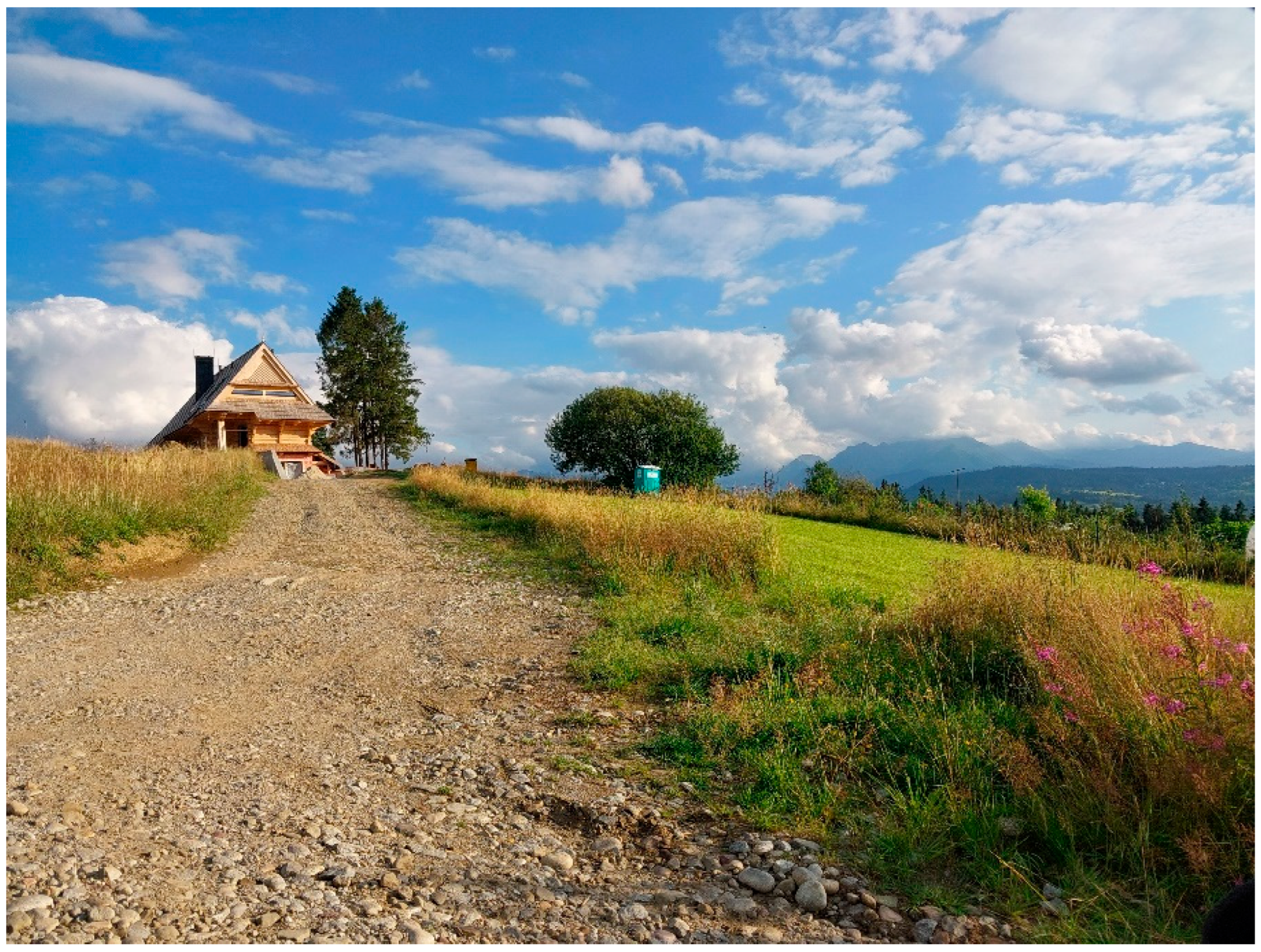
Accommodation facilities offered by the municipality mainly consist of private lodgings and guesthouses. The natural conditions of the analyzed area, i.e., the landform, short vegetation period, and poor soils result in an ongoing process of successive reduction in the arable land area and transformation of arable fields into grassland. The existing development sites are concentrated in the areas characterized by a relatively flat landform (river valleys and mountain slopes). Guesthouse and service development is concentrated primarily along main roads leading through invested areas. However, the phenomenon of development dispersion into the previously uninvested areas is observed (Scheme 1).
Tourist attraction to an area fosters an increased investor interest, which is reflected, for example, in high real estate transaction prices, short period of real estate exposure on the market prior to its sale, or high activity of real estate agencies.
The Bukowina Tatrzańska municipality was selected as the case study area due to its exceptional natural and scenic qualities, which are unparalleled in the Polish Carpathians. The coexistence of multiple overlapping forms of environmental protection—including a national park, Natura 2000 sites, and a protected landscape area—combined with increasing investment pressure, makes it a unique and critical site for examining the implications of legal loopholes in spatial planning.

3.2. Methedology of the Study and Data Collection

The examples of spatial development presented in this study refer to the realization of investments where the municipality was excluded from the decision-making process (investments are realized based on a notification in the areas without a valid local plan and without an issued decision on land use and zoning conditions). The risks related to the protection of spatial order were identified and the risks resulting from legal solutions were indicated. Part of the development is carried out in accordance with the provisions of the law; however, the development location in the areas of natural and landscape value, should be subject to more stringent rules.
The authors of this study put forward the following research questions:
1.
What is the scale of individual recreational buildings constructed without municipal approval, despite the refusal to issue zoning decisions?
2.
What impact do individual recreational buildings constructed in areas subject to development bans have on the natural environment and landscape?
3.
Are individual recreational investments still being implemented without the consent of local authorities?
To carry out the research purpose, a field inventory of the municipality was performed and covered the new individual recreation buildings. The investments were related to the findings of the Study of land use conditions and directions in the spatial planning system of the Bukowina Tatrzańska municipality [33].
The research was conducted in the following stages:
  • A review of the relevant literature and formulation of the research objective;
  • Identification of the scale of decisions refusing to issue zoning conditions for individual recreational investments (based on data from the Bukowina Tatrzańska Municipal Office);
  • Determination of the development status of properties for which zoning decisions for individual recreational buildings were refused (field inspection within the municipality of Bukowina Tatrzańska);
  • Analysis of local spatial policy provisions for developments implemented without municipal approval;
  • Assessment of the consequences resulting from the construction of individual recreational buildings in conflict with local spatial planning policies;
  • Formulation of answers to the research questions;
  • Development of conclusions and recommendations.
The analysis of drafted decisions refusing to specify zoning conditions was conducted in the period from January 2018 to July 2024, based on an interview with employees of the Bukowina Tatrzańska Municipal Office. The compilation allowed identifying investments realized despite the absence of approval issued by the head of the municipality. All issued refusal decisions were analyzed and it was revealed which investments were implemented despite the lack of municipal approval, during unclearly interpreted regulations.

3.3. Legal Basis for the Realization of Individual Recreation Buildings

Until September 2023, the regulations allowed the construction of free-standing one-story individual recreation buildings, understood as buildings intended for periodic recreation, with a construction area of up to 35 m2, while the number of such buildings on a plot could not exceed one per each 500 m2 of the plot area (Art. 29. 1. of the Act of 7 July 1994 Construction Law) [30]. The problem consisted of a certain free interpretation of the legal regulations, which did not impose including the zoning decision for the location of an investment in the absence of a local plan. Having previously tried unsuccessfully to obtain a zoning decision, some investors decided to realize the investment on the basis of a notification filed to the architectural and construction supervision authority. The latter had no legal basis to demand the basis for the investment location (zoning decision), in the absence of a local plan.
The current provisions of the Construction Law (i.e., Journal of Laws 2024, item 725, as amended) [30] have expanded the catalog of investments which do not require a construction permit decision, however, require a notification (Art. 29.1 item 16). The provision allows, for example, the enlargement of an individual recreation building realized based on a notification and precisely defines parameters of the building. At present, it is possible to realize, upon notification, free-standing single-story individual recreation buildings understood as buildings intended for periodic recreation, the building area of which is up to 35 m2 and above 35 m2, but no more than 70 m2, with a span of structural elements up to 6 m and an overhang of supports up to 2 m, but the number of these buildings on a plot cannot exceed one per each 500 m2 of the plot area.
An individual recreation building has to be a single-story structure, without a usable attic, but may have an open mezzanine, exactly as in the case of 35 m2 houses so far. These buildings have to meet the requirements of the local development plan, and in the absence of such a plan, a zoning decision is required. In addition, a plot does not have to be provided with the possibility of connecting its utilities or directly the building to water, sewage, electricity, and heating networks, if the zoning decision does not specify such requirements and the local development plan does not determine them either. They constitute objects of temporary use, i.e., the total period of residence in the building should not exceed 180 days per year. The building does not have to meet its own housing needs and can be built without a construction project. It is enough to provide the architectural and construction administration office with a printout of the construction notification, a map with the drawing of a building, as well as illustrative views and projections showing the designed building. If the authority has no objections, construction work can begin after 21 days (this is known as the so-called tacit approval).
Interestingly, an individual recreation building can be rented, resold, or several houses can be built provided only one house per every 500 m2 of land is erected. This results in an increased interest in investing in individual recreation buildings, especially in the naturally attractive areas, in the places featuring demand for recreational buildings, both for the purpose of acquiring ownership and short-term rental during the leisure period.

4. Results

4.1. Realization of an Investment After a Decision Refusing to Determine the Zoning Conditions Was Issued

Currently, 50 local development plans are in force in the Bukowina Tatrzańska municipality, some of which are drawn up as amendments to the local development plan. In addition to the areas covered by the currently binding local plans, approx. 95 decisions on zoning and land development conditions are issued annually in the municipality of Bukowina Tatrzańska. The decisions are issued at the request of an investor, after meeting the conditions specified by the provisions of law [2], including the principle of good neighborliness, access to public road, sufficient technical development of the plot, no need to change the designation of agricultural land for non-agricultural purposes, and compliance with separate provisions of law. In the municipality of Bukowina Tatrzańska, several decisions refusing to issue a zoning decision are also made annually. Moreover, a discontinuation of proceedings at the request of the investor usually takes place in situations where the project has not received approval from the municipality authorities. The number of decisions refusing to issue a zoning decision in the municipality of Bukowina Tatrzańska, in the period from January 2018 to July 2024, has been summarized below, along with the requested investment project (Table 1).
Based on the above presented summary, an increase in the number of proceedings on the issuance of zoning decisions which ultimately received a refusal to issue a decision was observed in the following years. The pressure of investors, often engaged in development activities, whose intention is to maximize profit, raises concerns. Hence, the applications to issue a decision relate to an investment project involving, in extreme case, eight single-family residential buildings, or the construction of ten individual recreation buildings with accompanying infrastructure. Here, attention should also be paid to the attempts aimed at changing the designation of individual recreation buildings to single-family residential buildings when they were developed in the areas not covered by the local plan and without a previously issued zoning decision.
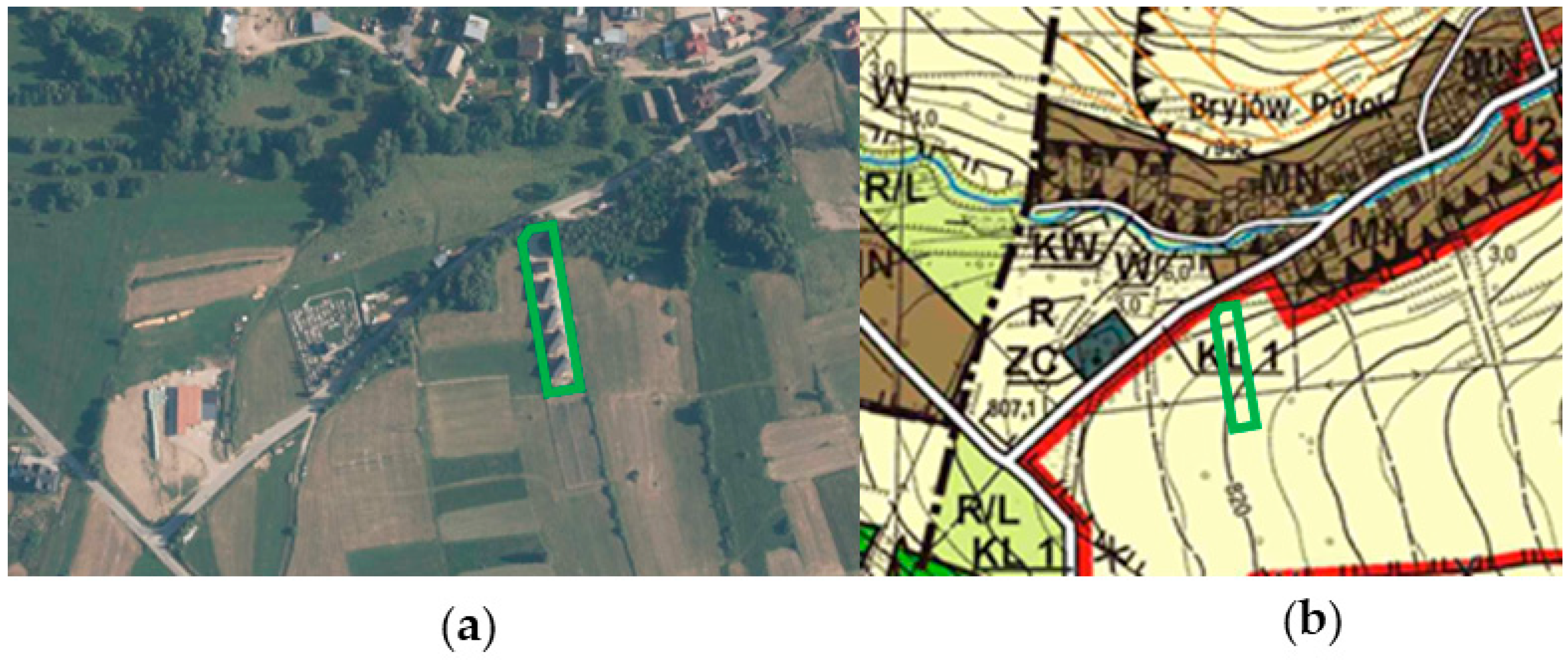
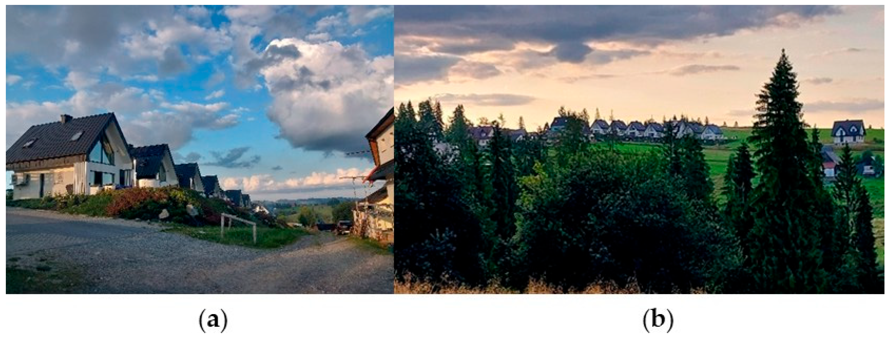
Individual recreation buildings completed (or under construction) in the areas without a valid local development plan, despite the lack of a positive zoning decision were identified in the villages of Rzepiska and Leśnica. The first example is located in Rzepiska and refers to the plots No. 314 and 5568. The investment area is situated outside the compact development of the village and is characterized by difficult access and public transport accessibility. The land is located within the area marked in the Study [33] by the symbol R/S1—an agricultural and recreational zone with the potential possibility of developing sports and recreational infrastructure, permitting the location of cubature facilities for service purposes only as the accompanying infrastructure. The Head of Bukowina Tatrzańska municipality issued the decision refusing the construction permit for four individual recreation buildings due to difficult access and the lack of good neighborliness. The investor realized the investment, despite the issued refusal, on the basis of a notification filed to the county office (Scheme 2, Figure 2a,b).
Another example refers to an investment currently underway in the village of Leśnica on the plot No. 1854/1 in the geodesic area of Leśnica (Scheme 3, Figure 3a,b). The individual recreation buildings are visible from the municipal road passing through the village. Six individual recreation buildings were completed on the hill. In 2019, the Head of Bukowina Tatrzańska municipality issued a decision for the site regarding the construction of a detached single-family residential building, prior to which, after reviewing the application, refused to determine the zoning conditions for the investment project involving the construction of six single-family residential buildings due to failure to comply with the condition under Art. 61(1)(1) of the Spatial Planning and Development Act [2].
The analyzed area is located in the Study document [33] in the area marked with the symbol R—agricultural land. In addition, the plot is situated in the natural landscape scenic exposure zone. In accordance with the provisions of the Study, the areas constituting natural terrain elevations of particular landscape significance, marked on the “Study drawing” as natural landscape scenic exposure zones, are protected. The purpose of such protection is to preserve the view of the ridges, to preserve the space of the ridges, and the panoramic view from the ridges. The zone should be taken into account in the local development plans though implementing, where possible, the appropriate arrangements to
  • Prohibit the location of cubature constructions (except for the upper stations of ski lifts and funicular railways);
  • Prohibit the location of new overhead technical infrastructure lines and equipment;
  • Prohibit the location of advertising;
  • Prohibit the introduction of high greenery;
  • Prohibit to change the landform [33].
In the village of Leśnica, in the area of Cipkowie estate, on the plots No. 3731/23 and 3731/24, another investment was located based on a notification (Scheme 4a,b; Figure 4a,b). The investor did not receive a zoning decision due to the planned high density of development (the applied high intensity of development) and lack of good neighborliness. The application included an investment project consisting in the construction of eight single-family residential buildings and a service building, a barbecue gazebo, playground for children with the accompanying infrastructure and the necessary construction equipment on the plots No. 3731/23 and 3731/24, located in Leśnica. The refusal resulted from the failure to comply with the condition under Art. 61(1)(1), of the Spatial Planning and Development Act of 27 March 2003 [2].
Despite the lack of a zoning decision, the buildings were realized using the possibility of developing individual recreation buildings based on a notification. Seven individual recreation buildings were realized along the mountain road.
The analyzed area is located in the Study document [33], in the area designated for agricultural purposes (marked with the symbol R in the Study drawing). In this case, the site is also located in the natural landscape scenic exposure zone—natural terrain elevations of particular scenic significance (natural landscape scenic exposure zone). As in the previous location, the goal of the protection is to preserve the view of the ridges, to preserve the space of the ridges, and the panoramic view from the ridges.

4.2. The Realization of Modular Buildings

The realization of individual recreation buildings proposed for sale as modular buildings is a highly negative phenomenon in the spatial development of the municipality. Their architectural form deviates from the style of regional architecture (Podhale and Spisz). Such features as roof geometry, roof slope angle, eave height, foundation height, materials used, architectural detail, colors, etc., are specified in the local plan, and in the absence of such a plan—in the zoning decision. The individual recreation buildings were realized based on a notification of the intention to carry out the investment presented at the county office, ignoring the procedure for issuing a zoning decision, or contrary to the provisions of the local plan. Modular buildings were identified in the villages of Brzegi and Leśnica in the municipality of Bukowina Tatrzańska (Scheme 5).
Single individual recreation facilities are progressively being built on the slopes of the Bukowina Tatrzańska ridge. Usually, the investments are carried out in places offering attractive landscapes, which should be particularly protected from investments, sometimes following an unsuccessful application process for a zoning decision allowing us to implement an investment. Investors frequently erect buildings in inaccessible areas, with difficult access, in isolation from development (Scheme 6). The progressive development on the mountain slopes results in the transformation of the municipality landscape. Such buildings are not erected in the areas covered by the local development plan, the provisions of which impose standards for the dimensions of facilities and the architectural form of buildings.
The buildings realized following the provisions of the local development plan or the decision on zoning conditions reflect the style of regional architecture both in their form and architectural detail (Scheme 7).

5. Discussion

According to Myczkowski Z. [34], it can be estimated that at least 50% of high-value and distinctive cultural landscapes in Poland remain at risk of intensive transformations. Similarly to Poland, in Italy, the reasons are rather endemic and behavioral, such as the obstinacy to build on owned land even if located in unsuitable areas (given the objective difficulty in exchanging one’s land with other more suitable ones), the will to avoid long requests for building permit, the construction of second homes in vacation places, and in areas where it would be forbidden to build for landscape and environmental protection, and the motivation to enhance real estate value [17].
It primarily results from a very low protection level of these areas in the local development plans, which do not even cover 80% of the country. Consequently, it brings about the dispersion of development and the freedom of activities based on the zoning decisions. The dominant changes in landscapes in Europe are driven by land use or land cover changes, coming from transformation of social, economic and ecologic attitudes towards landscape sites [6,24]. However, in addition to the aforementioned decisions, there are also investments realized on the basis of a notification to the architectural and construction administration, including primarily the individual recreation buildings.
The municipality of Bukowina Tatrzańska, due to its natural and landscape values, is covered by various forms of nature protection, including the Tatra National Park and the area of Natura 2000—“Białka Valley”. Despite that, recreational investments are often carried out in the areas which should be protected in accordance with the Study of land use conditions and directions in the spatial planning system of the municipality. The examples of recreational buildings realized in agricultural and recreational zones or natural landscape scenic exposures indicate the need for stricter regulations and control in these areas.
Unfortunately, the documents included in the Study of land use conditions and directions in the spatial planning did not provide the basis for issuing negative decisions regarding zoning conditions. The zoning decision is not a discretionary one and is a typical example of a related act in which the authority is required to determine the facts and examine them for compliance with the provisions of law. If no legal provision opposes the investment intention, the authority is obliged to issue a positive decision [35]. The amendment to the law, introduced on 24 September 2023, will come into effect after the general plan is passed and comes into force, but no later than the end of 2025.
One of the most important problems identified in the course of the research is the lack of effective tools to control spatial development in the municipalities such as Bukowina Tatrzańska. Despite the applicable provisions of the Construction Law [29], allowing the realization of individual recreation buildings based on a notification, their free interpretation by investors, as well as the architectural and construction supervision authority leads to the emergence of disharmonious development in the landscape of areas presenting natural and cultural value. The examples of investments realized in the villages of Rzepiska and Leśnica, discussed in the study, show that despite the municipality’s refusal to issue a zoning decision, investors did realize their projects taking advantage of the possibility to notify the county office of their investment intention. In addition, the investments often involve complexes of individual recreation buildings ultimately intended for rent (not for own use). Among the presented investments, there were four, six, and seven buildings in the realized complex. This raises a question about the actual function of the buildings, which is related to tourism services rather than individual recreation. As the authors of the study entitled Legal and Urban Planning Perspective in Spatial Planning [36] point out, it is precisely when considering the instruments aimed at achieving the goals of spatial planning that the protection and organization of spatial order needs to be taken into account. These measures should be strongly differentiated with regard to diverse areas (and their needs). The analyses presented in the source literature show the extent of dissimilarity occurring in relation to different types of areas and how it should affect the formation of urban planning standards, for example [37].
The progressive urbanization of scenic areas, such as the mountain slopes in Bukowina Tatrzańska, leads to a gradual change in the character of these areas. Recreational development, including modular buildings that deviate from regional architecture, is contributing to an ongoing cultural degradation of the landscape. Moreover, the examples of investments realized in the area of Cipkowie and Stasiki estates in Leśnica and on the slopes in Rzepiska show that buildings are often erected in isolation from the compact development of the village, in hard-to-reach places, in the areas protected from investment. Even in a situation where the municipality refuses to issue a decision, investors find a “legal loophole” to realize buildings “based on a notification” with a building area of up to 35 m2.
The current provisions of the Construction Law, which allow the construction of recreational buildings only after informing the authority of the intention to erect them (based on a notification) call for an urgent revision in the context of protecting valuable natural and scenic areas. It is necessary to introduce stricter requirements regarding the location and architectural form of such buildings in order to limit further development in rural areas. In addition, it is imperative to implement effective control mechanisms to prevent the realization of investments against the decisions of local authorities. Meanwhile, as pointed out by Barełkowski R. [38], the legal system today is experiencing an obvious crisis. Its perception by the public is strongly negative, citizens see the law more as a tool for realizing the vested interests of lobbying groups, e.g., groups of property owners or local governments, as the instruments to serve local political agendas. Barriers to the enforcement of spatial planning law are also recognized by Hersperger et al. [39], Hamdan [40], and Dianto and Cahyaningtyas [41].
According to the provisions of the Spatial Planning and Development Act [2], everyone is entitled—within the limits of the law—to develop the land which they have legal title to in accordance with the conditions provided by the local development plan or following the zoning and land use decision, if this does not violate the public interest protected by law and third parties. An important caveat is highlighted by Reimer et al. [42], for whom the real way in which the law is applied is manifest in the planning practice of a country. That is, the legal framework is merely a corridor along which to navigate in different ways [43].

6. Conclusions

The research allowed us to answer the following problematic questions:
  • Regarding the scale of individual recreational buildings constructed without municipal approval, this study confirmed numerous cases of such developments carried out despite formal refusals to issue zoning decisions. Field inspections in villages such as Leśnica and Rzepiska revealed that investors proceeded with construction under the notification procedure, effectively bypassing the municipality’s authority. This demonstrates a systemic loophole in the current legal framework (Question 1).
  • The environmental and landscape impacts of these developments are considerable. The buildings are often located in ecologically sensitive areas, such as protected landscape zones and scenic exposures, where construction is normally restricted. Their presence contributes to spatial disorder, landscape fragmentation, and the erosion of cultural identity, especially due to architectural inconsistency with regional traditions. The cumulative effect of such developments threatens biodiversity and the visual integrity of the natural environment (Question 2).
  • This study finds that such unauthorized recreational developments are ongoing, indicating an urgent need for reform. The phenomenon persists because the notification-based system lacks adequate oversight and enforcement mechanisms. Investors continue to exploit legal ambiguities, especially in areas not covered by local development plans, which currently make up a significant portion of the municipality (Question 3).
The imperfection of civil, land, urban, and other branches of legislation regulating land allocation and issuing permits for the construction of real estate, as well as bureaucratic obstacles, practically pave the way for unauthorized construction [44]. The problem is to moderate the law with regard to individual recreation buildings. In the area of the Bukowina Tatrzańska municipality, individual recreation buildings realized in recent years have been identified based on a notification of the intention to erect them filed to the county office, despite the previous refusal to issue a decision. In view of the above, the following is recommended:
1.
Strengthening the role of local development plans in the municipality by covering larger areas of the municipality with the local plans in force to eliminate the possibility of erecting individual recreation buildings in the areas subject to a ban on development and implementing detailed regulations and rules for development and land use.
2.
Revision of the Construction Law—imposing stricter requirements for construction notifications and tightening regulations on the realization of investments without a local development plan.
3.
Increasing control over the realization of investments—implementing more effective mechanisms to supervise compliance with the Construction Law and local development plans.
4.
Considering the introduction of diversified measures and principles for shaping spatial order that take into account the protection of landscapes presenting natural and cultural value.
The implementation of these measures will allow the preservation of the unique natural and landscape values of the Bukowina Tatrzańska municipality and ensure sustainable development of the region in accordance with the principles of environmental protection.
Future research should examine the long-term socio-economic and environmental consequences of recreational sprawl in protected areas. Comparative studies across regions or countries could yield valuable insights into the effectiveness of different planning approaches and legal instruments.

Author Contributions

Conceptualization, M.H.; Methodology, M.H.; Software, B.R.; Validation, M.H. and B.R.; Formal analysis, M.H. and K.O.; Investigation, M.H.; Resources, M.H., K.O. and B.R.; Data curation, M.H.; Writing—original draft preparation, M.H.; Writing—review and editing, M.H., K.O. and B.R.; Visualization, M.H.; Funding acquisition, B.R., M.H. and K.O. All authors have read and agreed to the published version of the manuscript.

Funding

This research received no external funding.

Institutional Review Board Statement

Not applicable.

Informed Consent Statement

Not applicable.

Data Availability Statement

The data used to support the findings of this study are available from co-responding author upon reasonable request.

Acknowledgments

Special acknowledgments are extended to the staff of the Bukowina Tatrzańska Municipal Office.

Conflicts of Interest

The authors declare no conflicts of interest.

References

  1. Szlachetko, K.; Szlachetko, J.H. Planowanie i Zagospodarowanie Przestrzenne. Komentarz; Wolters Kluwer: Warszawa, Poland, 2023; pp. 1–15. [Google Scholar]
  2. Act of 27 March 2003 on Spatial Planning and Development (Consolidated Text: Journal of Laws of 2024, Item 1130). Available online: https://isap.sejm.gov.pl/isap.nsf/download.xsp/WDU20030800717/U/D20030717Lj.pdf (accessed on 30 August 2024).
  3. Woźniak, M. Ład Przestrzenny Jako Paradygmat Zrównoważonego Gospodarowania Przestrzenią [Spatial Order as a Paradigm of Sustainable Space]. Białostockie Stud. Prawnicze 2015, 18, 167–182. [Google Scholar] [CrossRef]
  4. Raszeja, E.; Szczepańska, M.; Gałecka-Drozda, A.; de Mezer, E.; Wilkaniec, A. Ochrona i kształtowanie krajobrazu kulturowego w zintegrowanym planowaniu rozwoju [Protection and Shaping of the Cultural Landscape in Integrated Development Planning]. Seria Zintegrowane Planowanie Rozwoju. Wydział Geografii Społeczno-Ekonomicznej i Gospodarki Przestrzennej Uniwersytetu im. Adama Mickiewicza w Poznaniu, Bogucki Wydawnictwo Naukowe, Poznań, 2022. Available online: https://wgseigp.amu.edu.pl/__data/assets/pdf_file/0020/394103/ochrona-i-ksztaltowanie-krajobrazu-kulturowego-w-zintegrowanym-planowaniu-rozwoju.pdf (accessed on 30 August 2024).
  5. Bőhm, A. Proponowane działania. [Proposed Actions]. Czas. Tech. 2008, z. 1-A, 137–146. Available online: https://repozytorium.biblos.pk.edu.pl/redo/resources/34386/file/suwFiles/BohmA_ProponowaneDzialania.pdf (accessed on 30 August 2024).
  6. Sallay, A.; Jombach, S.; Filepne Kovács, K. Landschanges and function lost landscape values. Appl. Ecol. Environ. Res. 2012, 10, 157–172. [Google Scholar] [CrossRef]
  7. Feranec, J.; Jaffrain, G.; Soukup, T.; Hazeu, G. Determining changes and flows inEuropean landscapes 1990–2000 using CORINE land cover data. Appl. Geogr. 2010, 30, 19–35. [Google Scholar] [CrossRef]
  8. Verburg, P.H.; Schulp, C.J.E.; Witte, N.; Veldkamp, A. Downscaling of land usechange scenarios to assess the dynamics of European landscapes. Agric. Ecosyst. Environ. 2006, 114, 39–56. [Google Scholar] [CrossRef]
  9. Hunziker, M. The spontaneous reafforestation in abandoned agricultural lands:perception and aesthetic assessment by locals and tourists. Landsc. Urban Plan. 1995, 31, 399–410. [Google Scholar] [CrossRef]
  10. Lasanta, T.; Laguna, M.; Vicente-Serrano, S.M. Do tourism-based ski resortscontribute to the homogeneous development of the Mediterranean mountains? A casestudy in the Central Spanish Pyrenees. Tour. Manag. 2007, 28, 1326–1339. [Google Scholar] [CrossRef]
  11. Caletrío, J. Tourism, landscape change and critical thresholds. Ann. Tour. Res. 2010, 38, 313–316. [Google Scholar] [CrossRef]
  12. Fischer, G.; Prieler, S.; van Velthuizen, H.; Berndes, G.; Faaij, A.; Londo, M.; de Wit, M. Biofuel production potentials in Europe: Sustainable use of cultivated land andpastures, Part II: Land use scenarios. Biomass Bioenergy 2010, 34, 173–187. [Google Scholar] [CrossRef]
  13. Antrop, M. Landscape Change and the Urbanization Process in Europe. Landsc. Urban Plan. 2004, 67, 9–26. [Google Scholar] [CrossRef]
  14. Keken, Z.; Kušta, T.; Langer, P.; Skaloš, J. Landscape structural changes between 1950 and 2012 and their role in wildlife–vehicle collisions in the Czech Republic. Land Use Policy 2016, 59, 543–556. [Google Scholar] [CrossRef]
  15. Grădinaru, S.R.; Iojă, C.I.; Pătru-Stupariu, I.; Hersperger, A.M. Are Spatial Planning Objectives Reflected in the Evolution of Urban Landscape Patterns? A Framework for the Evaluation of Spatial Planning Outcomes. Sustainability 2017, 9, 1279. [Google Scholar] [CrossRef]
  16. Nazarnia, N.; Schwick, C.; Jaeger, J.A. Accelerated urban sprawl in Montreal, Quebec City, and Zurich: Investigating the differences using time series 1951–2011. Ecol. Indic. 2016, 60, 1229–1251. [Google Scholar] [CrossRef]
  17. Romano, B.; Zullo, F.; Fiorini, L.; Marucci, A. Illegal building in Italy: Too complex a problem for national land policy? Cities 2021, 112, 103159. [Google Scholar] [CrossRef]
  18. Petrella, B.; de Biase, C. A typical Italian phenomenon. The unauthorized building. Int. J. Civ. Struct. Eng.–IJCSE 2015, 2, 221–224. [Google Scholar]
  19. Zanfi, F. The Città Abusiva in Contemporary Southern Italy: Illegal Building and Prospects for Change. Urban Stud. 2013, 50, 3428–3445. [Google Scholar] [CrossRef]
  20. Šostak, O.R.; Kutut, V. Investigation into expansion of illegal construction in the National Park of Curonian Spit. Bus. Theory Pract. 2009, 10, 223–232. [Google Scholar] [CrossRef]
  21. Burkšiene, V.; Dvorak, J. Performance Management In Protected Areas: Localizing Governance of the Curonian Spit National Park, Lithuania. Public Adm. Issues 2020, 105–124. [Google Scholar] [CrossRef]
  22. Voskresenskaya, E.; Zhilskiy, N. Theoretical and practical aspects of unauthorized construction: The matter of legalization and demolition. E3S Web Conf. 2023, 371, 02052. [Google Scholar] [CrossRef]
  23. Act of 7 July 2023 Amending the Act on Spatial Planning and Development and Certain Other Acts (Journal of Laws of 2023, Item 1688). Available online: https://isap.sejm.gov.pl/isap.nsf/download.xsp/WDU20230001688/O/D20231688.pdf (accessed on 30 August 2024).
  24. Różycka-Czas, R.; Czesak, B.; Cegielska, K. Towards Evaluation of Environmental Spatial Order of Natural Valuable Landscapes in Suburban Areas: Evidence from Poland. Sustainability 2019, 11, 6555. [Google Scholar] [CrossRef]
  25. Lechowska, E. Planowanie przestrzenne na poziomie lokalnym—Powiązanie teorii z praktyką [Spatial Planning at Local Level—Linking Theory and Practice]; Polska Akademia Nauk, Komitet Przestrzennego Zagospodarowania Kraju, TOM 15/207: Warszawa, Poland, 2022. [Google Scholar]
  26. Kozłowski, L. Kształtowanie ładu przestrzennego jako zadanie badawcze geografii historycznej. Acta Univ. Lodziensis. Folia Geogr. Socio-Oeconomica 2016, 25, 5–24. [Google Scholar] [CrossRef]
  27. Mierzejewska, L. Zrównoważony rozwój miasta, wybrane sposoby pojmowania, koncepcje i modele [Sustainable development of a city: Selected theoretical frameworks, concepts and models], Problemy Rozwoju Miast. Kwart. Nauk. Inst. Rozw. Miast 2015, 3, 5–11. Available online: https://bazekon.uek.krakow.pl/171413931 (accessed on 30 August 2024).
  28. Mikołajczyk, M.; Raszka, B. Multidimensional Comparative Analysis as a Tool of Spatial Order Evaluation: A Case Study from Southwestern Poland. Pol. J. Environ. Stud. 2019, 28, 3287–3297. [Google Scholar] [CrossRef] [PubMed]
  29. Act of 7 July 1994—Construction Law (Consolidated Text: Journal of Laws of 2024, Item 725, as Amended). Available online: https://isap.sejm.gov.pl/isap.nsf/download.xsp/WDU19940890414/U/D19940414Lj.pdf (accessed on 10 September 2024).
  30. Act of July 7, 1994 Construction Law (Consolidated Text: Journal of Laws of 2020, Item 1333). Available online: https://isap.sejm.gov.pl/isap.nsf/download.xsp/WDU20200001333/U/D20201333Lj.pdf (accessed on 10 September 2024).
  31. Formularz Danych Dla Obszaru Chronionego Krajobrazu [Data form for the Protected Landscape Area]. Generalna Dyrekcja Ochrony Środowiska. Available online: https://crfop.gdos.gov.pl/CRFOP/download/pdf/PL.ZIPOP.1393.OCHK.279.pdf (accessed on 15 May 2025).
  32. Uchwała Nr XX/274/20 Sejmiku Województwa Małopolskiego z dnia 27 kwietnia 2020 r. w sprawie Południowomałopolskiego Obszaru Chronionego Krajobrazu (Dziennik Urzędowy Woj. Małopolskiego z dn. 22 maja 2020 r., poz. 3482) [The Protected Landscape Area Covers Attractive Landscapes; Resolution No. XX/274/20 of the Małopolskie Voivodship Parliament, 27 April 2020 (Journal of Laws of the Małopolskie Voivodship of 22 May 2020, no. 3482). Available online: https://edziennik.malopolska.uw.gov.pl/legalact/2020/3482/ (accessed on 28 August 2024).
  33. Studium Uwarunkowań i Kierunków Zagospodarowania Przestrzennego Gminy Bukowina Tatrzańska [The Study of Land Use Conditions and Directions in the Spatial Planning System of the Bukowina Tatrzańska Municipality], Uchwała Rady Gminy Bukowina Tatrzańska Nr XLII/352/2022 z dnia 25 Maja 2022 r. Available online: https://www.google.com/url?sa=t&source=web&rct=j&opi=89978449&url=https://ugbukowinatatrzanska.pl/file/get/GMINA/Rada_Gminy/Uchwaly/2022/Za%25C5%2582%25C4%2585cznik%2520Nr%25205%2520do%2520zmiany%2520Studium.pdf&ved=2ahUKEwirlYCd6LCNAxXqxAIHHZNpAggQFnoECDMQAQ&usg=AOvVaw3GXDHSpmvmFVPrbsv8UPfV (accessed on 2 August 2024).
  34. Myczkowski, Z. Program ochrony krajobrazu kulturowego Polski. Krajobrazy niezwykłe–krajobrazy ginące. In Krajobrazy Europy; Drapella-Hermansdorfer, A., Mycak, O., Surma, M., Eds.; Krajobraz Jako Wyraz Idei i Wartości; The program of protection of the cultural landscape of Poland. Extraordinary landscapes—Disappearing Landscapes; Oficyna Wydawnicza Politechniki Wrocławskiej: Wrocław, Poland, 2019; pp. 27–41. Available online: https://dbc.wroc.pl/Content/75728/Krajobrazy_Europy_Krajobraz_jako_wyraz_idei_i_wartosci_.pdf (accessed on 28 August 2024).
  35. Dobkowska, B. Decyzja o warunkach zabudowy dla całej działki ewidencyjnej czy jej części? [Decision on development conditions for the entire cadastral plot or part of it?]. UWM Stud. Prawnoustr. 2022, 58, 2022. [Google Scholar] [CrossRef]
  36. Nowak, M.J.; Markowski, T.; Bąkowski, P.; Lorens, P.; Blaszke, M.; Zachariasz, I.; Szlachetko, J.; Giedych, R.; Tomczak, A.A.; Brudnicki, J.; et al. Perspektywa Prawna i Urbanistyczna w Planowaniu Przestrzennym. Wybrane Zagadnienia [Legal and Urban Perspective in Spatial Planning. Selected Issues]; Polska Akademia Nauk, Komitet Przestrzennego Zagospodarowania Kraju: Warszawa, Poland, 2022; Volume 13, p. 205. [Google Scholar] [CrossRef]
  37. Śleszyński, P.; Nowak, M.; Sudra, P.; Załęczna, M.; Blaszke, M. Economic Consequences of Adopting Local Spatial Development Plans for the Spatial Management System: The Case of Poland. Land 2021, 10, 112. [Google Scholar] [CrossRef]
  38. Barełkowski, R. Prawo—czynnik instrumentalizacji przestrzeni [w]. In Krajobrazy Europy; Drapella-Hermansdorfer, A., Mycak, O., Surma, M., Eds.; Krajobraz Jako Wyraz Idei i, Wartości; Oficyna Wydawnicza Politechniki Wrocławskiej: Wrocław, Poland, 2019; Available online: https://dbc.wroc.pl/Content/75728/Krajobrazy_Europy_Krajobraz_jako_wyraz_idei_i_wartosci_.pdf (accessed on 30 August 2024).
  39. Hersperger, A.; Mueller, G.; Knöpfel, M.; Siegfried, A.; Kienast, F. Evaluating outcomes in planning: Indicators and reference values for Swiss landscapes. Ecol. Indic. 2017, 77, 96–104. [Google Scholar] [CrossRef]
  40. Hamdan, M. Law enforcement on the issuance of construction permits violating spatial planning in Medan City. IOP Conf. Ser. Earth Environ. Sci. 2020, 452, 012073. [Google Scholar] [CrossRef]
  41. Dianto, R.; Cahyaningtyas, I. Administrative Law Enforcement against Urban Spatial Planning Based on the Spatial Planning Law. Int. J. Soc. Sci. Hum. Res. 2021, 4, 1174–1179. [Google Scholar] [CrossRef]
  42. Reimer, M.; Getimis, P.; Blotevogel, H.H. (Eds.) Spatial Planning Systems and Practices in Europe: A Comparative Perspective on Continuity and Changes; Routledge: London, UK, 2014. [Google Scholar]
  43. Nowak, M.J.; Mitrea, A.; Filepne Kovács, K.; Jürgenson, E.; Legutko-Kobus, P.; Petrișor, A.-I.; Simeonova, V.; Blaszke, M. Uncovering Spatial Planning Values through Law: Insights from Central East European Planning Systems, Instytut Geografii i Przestrzennego Zagospodarowania Polska Akademia Nauk. EUROPA XXI 2024, 47, 5–24. [Google Scholar]
  44. Storozheva, A.; Dadayan, E.; Letyagina, E. Unauthorized Building as an Object of Improper Civil Construction. IOP Conf. Ser. Mater. Sci. Eng. 2021, 1079, 032075. [Google Scholar] [CrossRef]
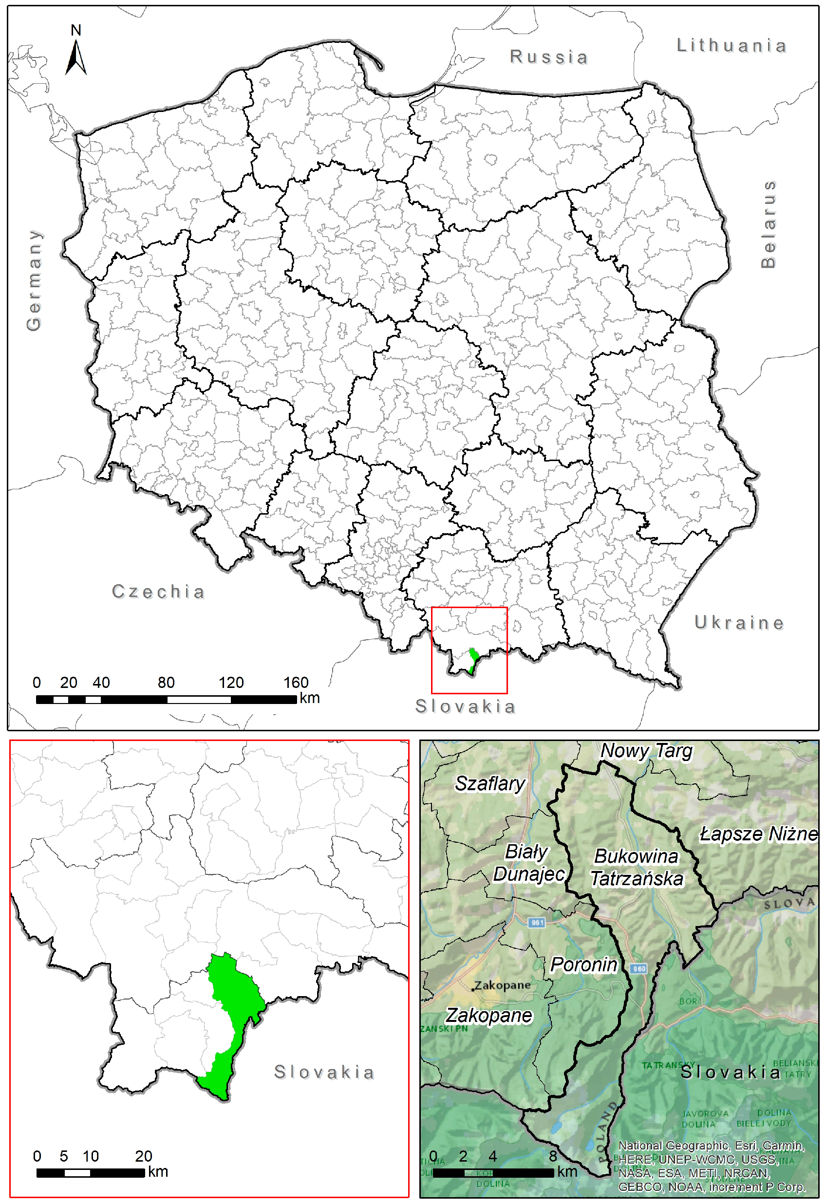
Figure 1. Location of the Bukowina Tatrzańska municipality at the background of Poland and the voivodship. Source: own elaboration.
Sustainability 17 04659 g001
Scheme 1. A view of the Tatra Mountains panorama and the slopes in the village of Rzepiska. Source: Hełdak M.
Sustainability 17 04659 sch001
Scheme 2. The view of individual recreation buildings realized based on a notification, located in Rzepiska in the area of Bryjów Stream (Bukowina Tatrzańska municipality). Source: Hełdak M.
Sustainability 17 04659 sch002
Figure 2. (a) Location of the investment—plots No. 314, 5568 Rzepiska estate; (b) the designation of the analyzed area in the Study of land use conditions and directions in the spatial planning system of the Bukowina Tatrzańska municipality [33]. The investment area is marked with a green border. Source: own study.
Sustainability 17 04659 g002
Scheme 3. The view of individual recreation buildings realized based on a notification, located in Leśnica in the area of Stasiki estate and Wierch Stasiki (Bukowina Tatrzańska municipality). Source: Hełdak M.
Sustainability 17 04659 sch003
Figure 3. (a) Location of the investment in the area of plot No. 1854/1, Leśnica estate; (b) the designation of the analyzed area in the Study of land use conditions and directions in the spatial planning system of the Bukowina Tatrzańska municipality [33]. The investment area is marked with a green border. Source: own study.
Sustainability 17 04659 g003
Scheme 4. (a,b): The view of individual recreation buildings located in Leśnica in the area of Cipkowie estate (Bukowina Tatrzańska municipality). Source: Hełdak M.
Sustainability 17 04659 sch004
Figure 4. (a) Location of the investment on plots No. 3137/23 and 3731/24, Leśnica estate; (b) the designation of the analyzed area in the Study of land use conditions and directions in the spatial planning system of the Bukowina Tatrzańska municipality [33]. The investment area is marked with a green border. Source: own study.
Sustainability 17 04659 g004
Scheme 5. The view of modular individual recreation buildings realized based on a notification, located in the village of Leśnica (Bukowina Tatrzańska municipality). Source: Hełdak M.
Sustainability 17 04659 sch005
Scheme 6. Landscape of the mountain slopes in the village of Rzepiska in the municipality of Bukowina Tatrzańska with the progressive localization of individual recreation buildings: modular and maintaining the character of regional architecture (buildings realized based on a notification). Source: Hełdak M.
Sustainability 17 04659 sch006
Scheme 7. The development realized in the village of Rzepiska in the area covered by the local development plan. Source: Hełdak M.
Sustainability 17 04659 sch007
Table 1. Summary of the decisions refusing to issue a zoning decision in the municipality of Bukowina Tatrzańska in the period 2018–2024.
Prepared Draft Decisions Refusing to Issue a Zoning Decision, Including for a Construction Project Consisting ofYear and Number of Draft Decisions Refusing to Issue a Zoning Decision:
2018201920202021202220232024
construction of a single-family residential building11 431
construction of two single-family residential buildings with accompanying infrastructure 4
construction of three single-family residential buildings with accompanying infrastructure 11
construction of four single-family residential buildings with accompanying infrastructure 11
construction of five single-family residential buildings with accompanying infrastructure 111
construction of six single-family residential buildings with accompanying infrastructure 11 1
construction of a single-family detached residential building, not more than two-story high, with a floor area of up to 70 m2 and with technical infrastructure 12
construction of eight single-family residential buildings and a service building, a barbecue gazebo, a playground for children with the accompanying infrastructure and the necessary construction equipment 1
construction of an individual recreation building up to 35 m2 with accompanying infrastructure 1
construction of two individual recreation buildings with accompanying infrastructure 1
construction of ten individual recreation buildings with accompanying infrastructure 1
construction of a free-standing shed, a free-standing platform for technical maintenance of the fence in recreational development 2
construction of three service buildings (tourist accommodation) with accompanying infrastructure, including the construction of technical infrastructure installations and connections, and the construction of other necessary building facilities 2
construction of six service buildings for the purposes of tourism and leisure with accompanying infrastructure 1
change in the use of five individual recreation buildings to single-family residential buildings 11
Source: own elaboration.
Disclaimer/Publisher’s Note: The statements, opinions and data contained in all publications are solely those of the individual author(s) and contributor(s) and not of MDPI and/or the editor(s). MDPI and/or the editor(s) disclaim responsibility for any injury to people or property resulting from any ideas, methods, instructions or products referred to in the content.