Article

The Western Greece Soil Information System (WΕSIS)—A Soil Health Design Supported by the Internet of Things, Soil Databases, and Artificial Intelligence Technologies in Western Greece

by
Georgios Kalantzopoulos
1,
Panagiotis Paraskevopoulos
2,3,
Georgios Domalis
4,
Aglaia Liopa-Tsakalidi
1,
Dimitrios E. Tsesmelis
1 and
Pantelis E. Barouchas
1,*
1
Department of Agriculture, University of Patras, 26504 Patras, Greece
2
Directorate of Agricultural Economy, Region of Western Greece, 26443 Patras, Greece
3
Laboratory of Soil Science & Agricultural Chemistry, Department of Natural Resources Management and Agricultural Engineering, Agricultural University of Athens, 11855 Athens, Greece
4
Novelcore, Par. Theofrastou 140, 26443 Patras, Greece
*
Author to whom correspondence should be addressed.
Sustainability 2024, 16(8), 3478; https://doi.org/10.3390/su16083478
Submission received: 4 December 2023 / Revised: 1 April 2024 / Accepted: 12 April 2024 / Published: 22 April 2024

Abstract

:
Soil quality is vital for ecosystem stability, impacting human, plant, and animal health. Traditional soil quality assessments are labor-intensive and costly, making them unsuitable for smart agriculture. To overcome this, Internet of Things (IoT) and artificial intelligence (AI) technologies are employed for sustainable agriculture, enabling real-time data collection and analysis, trend identification, and soil health optimization. The Western Greece Soil Information System (WΕSIS) offers open-access data and services for soil health and sustainability. It includes modules for soil quality indicators, sustainable fertilization management zones, soil property distribution, prediction, mapping, statistical analysis, water management, land use maps, digital soil mapping, and crop health calculation. Integrating the IoT and AI allows for real-time and remote monitoring of soil conditions, managing soil interventions adaptively and in a data-driven way, enhancing soil resources’ efficiency and sustainability, and increasing crop yield and quality. AI algorithms assist farmers and regional stakeholders in optimizing production lines, methodologies, and field practices, reducing costs and increasing profitability. This promotes a circular economy, a soil- and climate-resilient future, biodiversity protection targets, and enhanced soil fertility and productivity. The proposed IoT/AI technical architecture can underpin the development of soil health monitoring platforms, integrating data from various sources, automating data collection, and providing decision support tools.

1. Introduction

A sensitive interface between the atmosphere, biosphere, hydrosphere, and lithosphere is the soil [1,2], which is recognized as highly critical to human, plant, and animal health. Soil’s functions for food production and ecosystem services are crucial for the survival of humanity. Soil health is “the capacity of soils to deliver multiple functional traits required to maintain ecosystem stability” [3]. The concept of “one health” has been expanded to include the connection between humans, animals, and ecosystems due to the globalization of health concerns [4]. Integrating soil within the growing “one health” idea redefines soil’s significance.
The capacity of living soil to support plant and animal productivity, maintain or improve water and air quality, and foster plant and animal health within the confines of a natural or managed ecosystem is known as soil health [5]. The health of the soil as a “living thing” is related to human health, and both must be in a condition of well-being with respect to their physical, chemical, and biological features [6]. Soil quality and security are two linked ideas that emphasize the role or function of soil in society, ecosystems, and agriculture [7]. Soil quality is “soil’s ability to sustain biological productivity, maintain environmental quality, and promote plant and animal health within ecosystem boundaries” [8]. Soil health and soil quality are often comparable [9]. Soil health is a more practical phrase for the research and farming communities in terms of today’s comprehensive management of soils and their assessment. This work presents the concept of soil health because it directly covers interactions between plant inputs and soil in establishing a healthy environment. According to Mankotia et al. [10], the most crucial traits of healthy soils are a slight slope, adequate depth, sufficient nutrient supply, the biodiversity of organisms, absence of weeds, resistance to degradation, high water capacity, and drainage of excess water amounts. There should be some overlap among these traits in healthy soils, as many represent qualities in soils’ physical, chemical, and biological domains.
Due to inadequate management, soils are under more stress than they can handle, leading to soil degradation. For soils to no longer be able to supply ecosystem services, soil degradation must result in a decrease or cessation of soil functions [11]. Soil degradation needs to be combatted and rehabilitated if the Sustainable Development Goals of the United Nations are to be achieved. The European Commission (EC) has set many goals in its Zero Pollution Action Plan, Biodiversity Strategy 2030, Farm to Fork Strategy, European Climate Law, Soil and Food Health Missions, and Biodiversity Strategy. All of the policies mentioned earlier and action plans specifically address soil, which is indirectly crucial for reaching climate neutrality in 2050. During the era of digital disruption, Agriculture 4.0 provides accurate and practical data on natural resources, particularly soil health, which is essential. The European Commission has recognized that soil resources in many parts of the world are being overexploited, degraded, and irreversibly lost.
However, for all these initiatives to succeed and for soil degradation mitigation strategies to be implemented correctly and effectively, it is crucial to recognize, evaluate, and adopt the right soil quality indicators. Currently, such indicators, where used, differ significantly in type (physical, chemical, or biological), intensity, sensitivity, and frequency of collection.
Today, soil quality assessment is generally based on laboratory evaluation, which is costly, time-consuming, and unsuitable for smart agriculture [12,13]. Moreover, recording these indicators is not sufficiently standardized or harmonized to be collected in a centralized manner. This will allow in-depth and region-wide analyses and proposals of the most suitable adaptation and mitigation measures.
Numerous metrics are used in soil health monitoring to quantify ecosystem services and soil function. In-depth field sampling and expensive laboratory analysis are typically required for soil health measurements, and their assessment is normally dependent on costly and labor-intensive laboratory evaluation [12,14,15]. The laboratory analysis, however, cannot dynamically track important biophysical features to aid in management choices. Additionally, the field soil analyses used to identify soil quality indicators (SQIs) are frequently expensive, labor-intensive, complicated, and require many chemicals [13,16]. In addition, soil health must be tracked regularly and in multiple locations. Every soil has its properties at different points in time. So, it is necessary to understand these properties in advance for better decision-making [17]. Due to scalability challenges, multiple causes of variability, and high costs, it is essential to design a low-cost monitoring system with master control over the soil indicators. Monitoring, reporting, and verification systems in agricultural soils are needed to monitor soil health progress. Soil-based methods for detecting degradation require a lot of labor and time. Remote methods can significantly reduce the volume of soil surveys. IoT and AI-based technologies are being used for sustainable agriculture.
Soil health management could undergo a revolution by integrating artificial intelligence (AI) and the Internet of Things (IoT). By enabling real-time data collection and analysis through AI, it becomes easier to identify trends and optimize soil health. However, no studies in the literature currently explore using AI and IoT in designing and monitoring soil health indicators or proposing effective intervention strategies. AI technologies can quickly process large amounts of data and provide insights into soil health based on complex algorithms and machine-learning techniques. Traditional methods, while reliable, can be more time-consuming and may not be able to process as much data as quickly. Both methods are important for understanding and improving soil health. AI technologies can complement traditional methods by providing additional insights and making the process more efficient. Soil health design is a concept that refers to the creation and application of practices and technologies that aim to improve soil’s quality and productivity, as well as its resilience to environmental stresses [18]. Soil health design involves the assessment of soil properties, such as moisture, temperature, pH, nutrients, organic matter, and biodiversity, and applying appropriate interventions, such as irrigation, fertilization, crop rotation, and conservation tillage [18].
The Internet of Things (IoT) and artificial intelligence (AI) are two emerging technologies that can underpin soil health design by providing data collection, analysis, and decision support. The IoT connects various devices and sensors to a network, enabling the exchange of information and control [19]. AI mimics human intelligence and learning, allowing the processing and interpretation of complex data and the generation of insights and recommendations [20].
By combining the IoT and AI, soil health design can benefit from the following advantages:
  • Real-time and remote monitoring of soil conditions, such as moisture, temperature, pH, nutrients, organic matter, and biodiversity [18,19].
  • Data-driven and adaptive management of soil interventions, such as irrigation, fertilization, crop rotation, and conservation tillage [20,21].
  • Increased yield and quality of crops, as well as reduced risks of pests, diseases, and environmental shocks [20,21].
  • Enhanced efficiency and sustainability of soil resources, such as water, energy, fertilizer, and land [21].
Therefore, soil health design underpinned by IoT and AI technologies is promising for achieving smart and sustainable agriculture.
This study designs the technical architecture of the Internet of Things and artificial intelligence (IoT/AI) that can underpin the development of soil health monitoring platforms. This paper reviews the research on soil health to add to the existing body of knowledge. It is suggested that an IoT/AI architecture is created to set up a sustainable soil platform that can be used as a remedy.

2. Materials and Methods

2.1. Conduct an Extensive Mapping of Currently Used and Newly Proposed Soil Health Indicators

The suggested approach for aggregating soil trend knowledge fills in the gaps between different data silos that contain various raw and processed information sources. The goal is to design an effective system to collect data and extract knowledge through a network of stakeholders [22], providing an artifact that can be reused by many actors in environmental stress, soil management, and agroecosystems without losing its accuracy and predictability. This tool leverages the harmonization of soil health indicators across multiple regional areas. It facilitates manual and automatic data collection through a platform for sustainable soil management, accompanied by IoT sensors and powerful analytics tools.

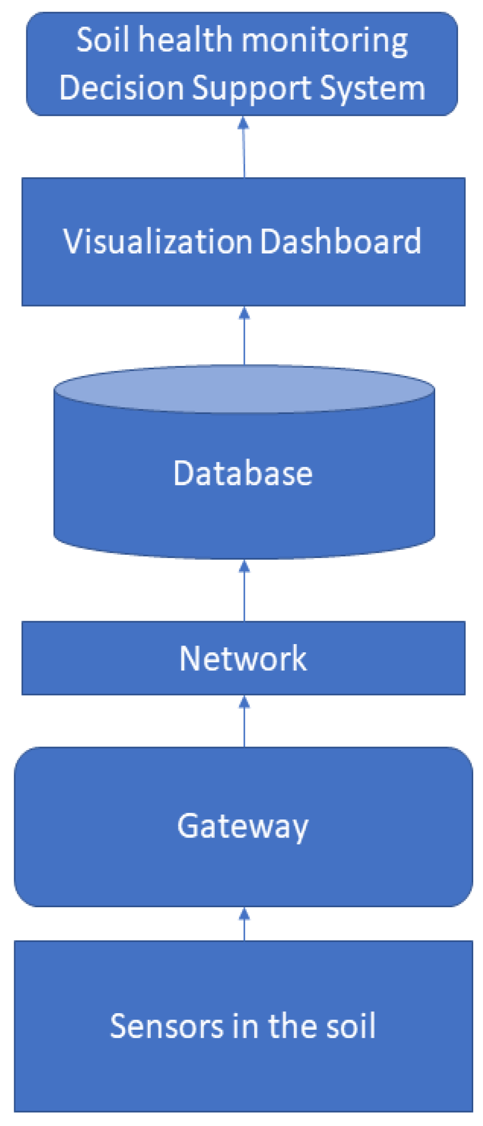
2.2. Deployment of a Smart Sensing and Monitoring System That Effectively Monitors On-Off Field Practices

This study aims to quantify supply and demand, crop performance, and environmental information and improve the efficiency of the supply chain of fertilizers, implements, and other necessary agrochemical inputs in terms of the distribution speed and coverage. This work involves developing an IoT sensor that measures the most critical soil elements (e.g., apparent electrical conductivity) for crops and other crops to be integrated into the collaborative resource monitoring framework, leveraging existing data sources and services. The electronics will be designed for the IoT soil sensor for productivity and environmental conditions [23], and the mechanical parts will be equipped with an anti-vibration housing with a physical fit specifically for field applications.

2.3. Development of an ICT Platform for Collecting Data from Multiple Sources

The aim is to develop an open-access IT platform that acts as a central point for the automated collection (e.g., through IoT and AI technologies) and further processing (harmonization, normalization, etc.) of the relevant data (e.g., soil quality indicators, other agroecological indicators, etc.). The soil health monitoring platform provides a user-friendly interface, and the users have access to a secure and searchable data repository, which also offers proper dynamic visualization (e.g., through graphs, heat maps, temporal evolution, etc.). The information exchange among stakeholders occurs in real-time, facilitating efficient monitoring and improved decision support (Figure 1). The platform is developed based on the end-user and security requirements and is further validated during the relevant work demonstrations [24].

2.4. Demonstration of the Woringk Automated Data Collection Process in the Region-Established Demo Sites

An automated data-gathering method is demonstrated at work at demo locations developed in the area. The work shows the adaptability and usefulness of the suggested IT system and next-generation data-gathering methodologies using IoT technologies as a region-common strategy for optimizing soil health indicators at specified demonstration locations. The objective is to influence the production of various crops (olive trees, superfoods, and vineyards) while assuring participation among policymakers and essential stakeholders.

2.5. Capacity Building and Advancement of the Proficiency of Farmers through Evidence-Based Cropping

Enhancing farmers’ ability to manage soil is a fundamental work objective and a crucial aspect of the agricultural domain. Accurate soil information, advanced AI-driven agents, and IoT solutions will provide clear, evidence-based insights for farmers on their crop status and production level, structuring the extracted knowledge with advanced data management and representation methodologies. The work also focuses on bridging the knowledge gaps among various soil-related sectors. In particular, it considers differences among diverse agricultural environments, cultural limitations, and environmental and soil health indicators to expand stakeholders’ knowledge capacity further.

2.6. Ensure Comprehensive Communication, Scientific Dissemination, and Brokerage of Knowledge

The aim is to ensure comprehensive communication, scientific dissemination, and knowledge brokerage to the public through scientific papers and publicly using our means of communication, such as social media, blogs, websites, etc. This work ensures the foreseen framework’s efficiency, effectiveness, robustness, and inclusiveness and thoroughly assesses its associated mechanisms and methodologies by seeking collaborations with projects under the same regional area. Dedicated activities from all the participating organizations ensure the maximization of the outreach of the results.

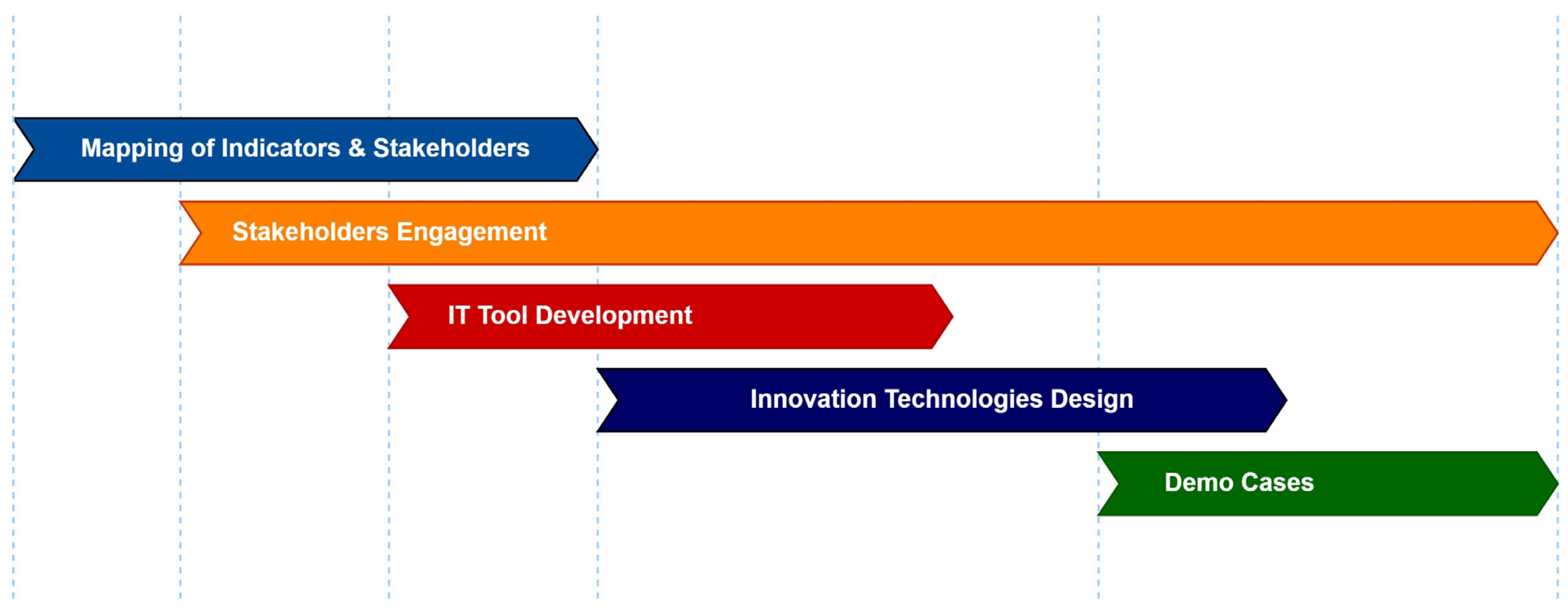
2.7. Development Approach

The development approach includes activities divided among (i) indicator and stakeholder mapping, (ii) stakeholder engagement, (iii) technology design and integration, and (iv) pilot demonstrations that dedicated teams of experts must carry out to enable a fast trickle-down development methodology [25], as shown in Figure 2.

2.7.1. Mapping of Indicators and Stakeholder Engagement

The demand for current, updatable soil information that can assist in decisions at various scales is rising, along with the sustainable use of soil resources. To provide soil data with higher spatial resolution, better mapping accuracy, and quantified uncertainty estimates, digital soil mapping has become more and more popular.
Satellite remote sensing has an unlimited scope as it is being used for land resource mapping, soil health mapping, and crop yield estimation. This work capitalizes on the Living Labs methodology [26] to proceed with the actual mapping of the relevant indicators through (i) a literature review of the existing soil resources and (ii) empirical research by conducting interviews and focus group discussions with key stakeholders (farmers, scientists, public bodies, and civil society), as well as through the deployment of online questionnaires that will be sent to form user-driven ecosystems. A multifaceted stakeholder engagement strategy is also developed, with knowledge-sharing actions aimed at contributing to scientific knowledge about soil stress monitoring and soil health indicators, communication actions, and dissemination actions.

2.7.2. Pilot Demonstration of High-Tech Indicator Collection

This will be achieved by collecting and processing the platform data from multiple functional traits, namely, (i) soil chemical properties such as the total organic carbon (TOC), total nitrogen (TN), pH, apparent electrical conductivity (ECa), exchangeable bases (K, Na, Ca, Mg), and soluble phosphorus (P), decrement of optimal SOC, exceedance of critical levels of mineral nitrogen, N limitation based on exceedance of the C/N ratio, decrement of optimal phosphorus, P limitation based on exceedance of the Zn/P ratio, critical pH levels, etc.; (ii) soil physical properties such as least limiting water range, infiltration rate, leaching potential, erosion potential, soil texture, soil depth, topsoil depth, soil bulk density, total available water, soil moisture at saturation, field capacity, wilting point; and (iii) soil biological properties and processes, continuously monitoring soil health and quality to test the viability and validity of such technical implementation. The pilot demonstration must be focused on small farms. Moreover, in particular pilots, different actions must be taken, such as (i) collecting and compiling data on soil health based on multiple functional traits and (ii) carrying out multiple regression analyses via the platform capable of delivering an accurate picture of soil health; (iii) providing suggestions about efficient crop and soil management to the farmers aimed at improving soil health; (iv) implementing the suggestions in the use cases and continuous monitoring of changes in soil health; (v) continuously monitoring the effects of the implementation on soil health based on the indicators; (vi) evaluating the results of the monitoring and highlighting any deficiencies in the indicators’ system; and (vii) applying any necessary changes to the data collection methods to the indicators’ system.

3. Results

3.1. Work Integration and Technical Approach

The integration starts with installing the central IoT module, aerial yield-monitoring units, and charging stations. These two elements, plus the permanent soil monitoring sensors, should be installed in cropping soils, providing constant local and connected data streams of information on soil health. Using their smartphones, tablets, or web-based applications, the farmers can keep track of their data and automatically upload it into a centralized and smart sharing network. Benefits: In the coming months and years, soil quality improvement has a promising outlook. Such a development will impact agricultural land longevity and ease devising crop strategies. Furthermore, adopting natural soil and crop health methods is anticipated to reduce the use of fertilizers, pesticides, and other chemicals in farming practices.
Enhanced digital soil mapping tools can provide a cost-effective means of geographical determination [27] to achieve sustainable soil management. This work introduces physical IoT hardware installations that collect in situ data from soil quality indicators that describe soil function, provide information from individual farms, and upload it to a connected and distributed network. This work proposes an open IT platform, under Creative Commons (CC) licenses, that acts as a centralized collection point for soil information based on the selected harmonized soil quality indicators. The IT platform allows various stakeholders to collect and exchange data while the system applies advanced data manipulation algorithms for data selection, normalization, and harmonization. The platform will provide a blueprint for a permanent IT infrastructure for farmers, soil experts, entrepreneurs, and policy authorities that will interface with currently employed systems and provide a solution where such systems still need to be implemented. A permanent connection to EU-wide databases is sought, especially with the JRC’s Soil Atlas database for the country, for constant updates. The proposed system obtains data from freely accessible national infrastructures, which it then integrates and utilizes to garner interest from producer associations and individual producers (Figure 3). This research seeks the possibility of interfacing the proposed platform with other infrastructures that could contribute to data provision. A vital paradigm of accessible data download platforms in Greece is Openhi.net https://system.openhi.net/ (accessed on 11 April 2024), which provides geographic information that complies with the Inspire Directive [28]. The system offers Web Map Services (WMS) and Web Feature Services (WFS) according to the Open Geospatial Consortium (OGC). It provides programmatic access to data of the telemetric stations and their associated time series via an API https://enhydris.readthedocs.io/en/latest/dev/webservice-api.html (accessed on 11 April 2024) [29,30] and free soil data series from numerous telemetric stations in the Epirus region [31].

3.2. The IoT System for Data Collection and Analytics

The soil property sensors and aerial yield-monitoring units measure the farming element properties constantly. All the data extracted from the field are transmitted and communicated through a central IoT module. Large amounts of data are collected from various farms, typically spanning 2–5 acres in land area, to create shared repositories, which may serve as a first step in providing analysis and predictions within a collective intelligence system. Since soil health seems to be so essential and is becoming better understood in terms of the success of specific crops and agricultural methods in general [32,33], the work would integrate not only existing and readily used soil sensors but also a new soil-sensor technology [34] aimed at measuring increased amounts of soil property data, potentially including increased numbers of the generally accepted essential [35] factors in soil for plant growth [36]. Soil moisture is another important factor for crop growth, and modern satellite technology allows its monitoring on a large scale and at regular intervals, allowing farmers to manage their water resources better [37]. In the case of aerial drone data for farming assessment, images covering diverse ranges of visible and NIR spectra should provide the necessary information to evaluate changes in crop growth, yield [38], and soil quality [39]. Table 1 contains some examples from the literature that suggest estimating soil quality indicators using remote sensing, collected or in situ data, and different data models.

3.2.1. Current Trends for Soil Databases

Soil Information Systems (SISs) and soil databases are crucial global tools for collecting, analyzing, and sharing soil data for understanding and managing the world’s soil resources [45]. These systems are essential for addressing international, national, and field-scale challenges. They provide high-quality soil information and data regarding comparability and spatial coverage. SISs have revolutionized how we understand and manage our soils, contributing significantly to sustainable agriculture and environmental conservation [46]. Some examples are the following [47,48,49,50,51,52,53]:
  • The Harmonized World Soil Database (HWSD) is a significant global soil database. It is a 30-s raster database with over 15,000 different soil mapping units. The HWSD combines regional and national soil information updates worldwide with the information contained within the 1:5,000,000 scale FAO-UNESCO Soil Map of the World.
  • The ISRIC—World Soil Information, which manages several unique collections worldwide. It is intensely interested in soil classification and actively supports the World Reference Base for Soil Resources (WRB). The ISRIC’s central database, WoSIS, contains soil class and property information from more than 190,000 soil profiles worldwide.
  • The Global Soil Information System (GLOSIS): The GLOSIS is an open-access spatial data infrastructure that combines soil information collected by national institutions and other data-holding entities. It provides a decentralized global soil data platform that is nationally/regionally federated and globally harmonized. This spatial data infrastructure system combines soil information collected by national institutions and other data-holding entities. It allows national institutes to compile and share their soil data and enables end-users to perform comparative studies on transboundary environmental issues.
  • The Australian Soil Resource Information System (ASRIS): The ASRIS consistently provides online access to the best publicly available information on soil and land resources across Australia.
These databases provide invaluable data for researchers, policymakers, and anyone interested in soil health and sustainability. They offer a comprehensive view of global soil properties, aiding in everything from agricultural planning to climate change modeling.

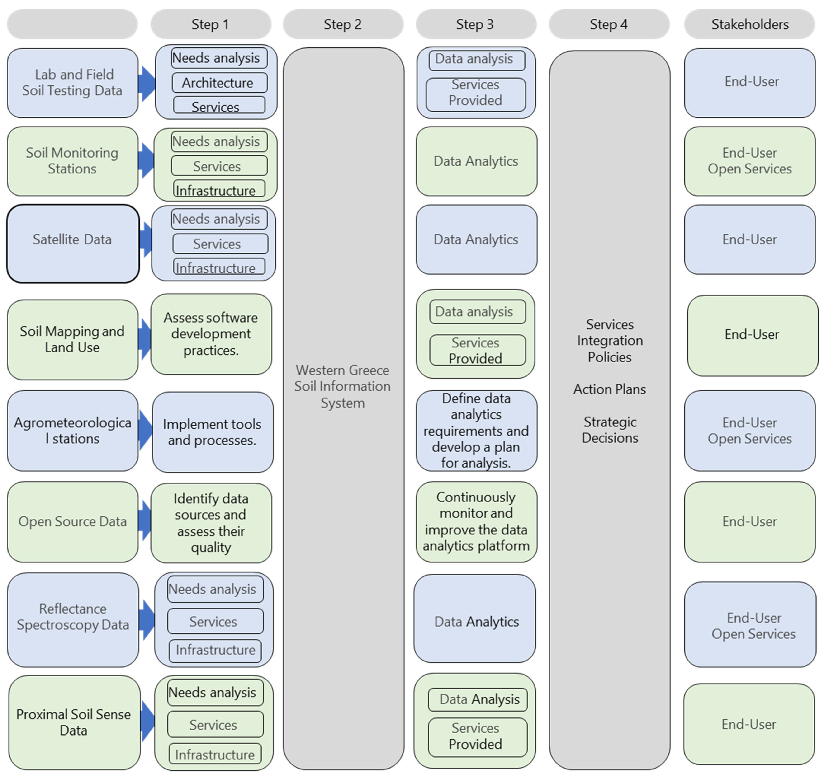
3.2.2. The Western Greece Soil Information System (WESIS) and the Pilot Areas

Data Collection Architecture

The system has multiple inputs, a database architecture where the data are stored, and various modern ML and AI techniques for data analysis (Figure 4). The model for gathering soil data is tested using widely used soil indicators in actual environments.
All the data sources are integrated into a central database. The proposed database architecture for the data collection consists of a central database that stores all the input collected data, which is the system’s core. It is a relational database management system (RDBMS) like PostgreSQL or MySQL or a NoSQL database like MongoDB, depending on the nature and volume of the data. The central database consists of tables (in RDBMS) or collections (in NoSQL databases) used to store different data sources:
  • Soil Analysis Data Table: Stores field and laboratory soil analysis data. Each record corresponds to a specific soil sample and includes attributes such as location, soil type, and various soil properties.
  • Soil Monitoring Stations Table: Stores data from soil monitoring stations. Each record corresponds to a specific station, including the location, sensor readings, and timestamp attributes.
  • Satellite Data Table: Stores satellite data. Each record corresponds to a specific satellite reading and includes attributes such as the location, timestamp, and various spectral data.
  • Soil Mapping Data Table: Stores soil mapping and land use data. Each record corresponds to a specific location, including the soil type and land use attributes.
  • Agrometeorological Stations Table: Stores data from agrometeorological stations. Each record corresponds to a specific station, including the location, weather conditions, and timestamp attributes.
  • Open-Access Databases Table: Stores open-source data from open-access databases or through interconnection with other databases.
  • Reflectance Spectroscopy Data Table: Stores reflectance spectroscopy data. Each record corresponds to a specific reading, including the location, mineralogical composition, and timestamp attributes.
  • Proximal Soil Sense Data Table: Stores proximal soil sense data. Each record corresponds to a specific sensor reading, including the location, sensor readings, and timestamp attributes.
ETL (extract, transform, load) processes integrate data from different sources into the central database. This procedure involves extracting data from the source, transforming it into a suitable format, and loading it into the central database. The database management system ensures the data’s integrity, security, and availability—the process of data cleaning, transformation, and standardization is applied to ensure consistency. It also provides functionalities for querying the data and performing various types of analyses.
The integrated data are then analyzed using various modern ML and AI techniques in soil science to derive insights into the soil properties and conditions. These techniques include regression, classification, clustering, dimensionality reduction, ensemble methods, neural nets, deep learning, transfer learning, reinforcement learning, natural language processing, word embedding, and predictive analytics. Table 2 presents some examples of modern ML and AI techniques in soil science.
The results of the data analysis are visualized using various graphical tools for straightforward interpretation. Reports are generated based on these visualizations. The insights derived from the data analysis are used to support decision-making in areas such as crop selection, irrigation management, and fertilizer application. This architecture allows for a comprehensive understanding of the soil conditions, leading to more effective agricultural practices and a paradigm of the AIoT (Artificial Intelligence of Things) [66] for sustainable soil management and applied soil science.
The Western Greece Soil Information System (WESIS) is designed to provide invaluable open-access data and services for researchers, policymakers, and anyone interested in precision farming, smart agriculture, soil health, and sustainability. It offers a comprehensive view of the soil properties in the Western Greece region, aiding in everything from agricultural planning, land use planning, and soil classification to climate change modeling. It is fully supported by the Western Greece Soil Laboratory (http://www.edafologiko.gr (accessed on 11 April 2024)), a regional infrastructure as a service connected with farmers, farmers’ associations, farmers’ cooperatives, stakeholders in the agrifood sector, and policymakers under the scientific supervision of the Soil Science Laboratory (SSLab) of the University of Patras under a funding agreement between the following nonprofit organizations: (i) Region of Western Greece, (ii) University of Patras and (iii) Municipality of Ilida. The proposed Western Greece Soil Information System (WESIS) is a comprehensive Soil Information System (SIS) with several output modules that will provide services to the stakeholders (end-users). Here is a brief description of its designed output modules:
  • Soil Quality Indicators: This module uses various indicators, including the pH, organic matter content, and nutrient availability, to evaluate the health and quality of soil.
  • Soil Management Zones for Sustainable Fertilization: This module identifies different zones within a field or region that can be used for targeted and sustainable fertilization practices.
  • Soil Properties Distribution and Variability: This module maps the distribution of various soil properties and their variability across a given area.
  • Soil Properties Prediction: This module uses machine-learning algorithms and historical data to predict future soil properties.
  • Soil Properties Mapping, Spatially, and Time Distributed: This module creates detailed maps of the soil properties over time and space.
  • Soil Properties Statistical and Geostatistical Analysis: This module analyzes the soil properties to identify trends, correlations, and other significant patterns.
  • Soil Water Management: This module provides information on the soil water-holding capacity and infiltration rates and guides irrigation management.
  • Land Use and Land Utilization Maps: This module generates maps showing current land use patterns and potential land utilization.
  • Digital Soil Mapping: This module uses remote sensing and GIS technologies to create digital maps of soil characteristics.
  • Calculation and Visualization of Crop Health: This module calculates and visualizes crop health across a field or region by integrating soil data with crop health indicators [67,68,69,70,71,72,73,74,75,76].
The system presented here tackles challenges at the global, national, regional, and field scales. It has been designed to provide high-quality, comparable soil information and data with extensive spatial coverage. The Western Greece Soil Information System (WESIS) has revolutionized our understanding and management of soil in the Region of Western Greece (RWG), making significant contributions to sustainable agriculture and environmental conservation. The proposed system provides a comprehensive view of the soil landscape, assisting with sustainable agricultural practices, environmental conservation efforts, and land management decisions. The Western Greece Soil Information System (WESIS) involves several techniques that must be implemented and calibrated correctly. Pilot sites have been selected to test these techniques. These areas are primarily agricultural land, with olive orchards being the predominant crop (Table 3). The farmers in these areas use precision agriculture techniques such as precision spraying, precision irrigation management, precision soil sampling, soil spectroscopic data, and remote-sensing radiometric data to optimize their yields.

4. Discussion

4.1. Information Architecture

The future work will include an IT platform that gathers and hosts the data, standardizes and normalizes it, and stores it in a database for future analysis or commercial exploitation. More pilot cases will demonstrate the automation of the data collection process and form the basis for future system modifications. The expected impact is to provide regional stakeholders with a standard methodology (indicators), an online repository for data streamlining and storage (an IT platform), and an automated data gathering solution (demonstrators), leading to a unified and comprehensive solution within the country area.

4.2. Contribution to the JRC or Other Regions

The creation of an indicator-based methodology for data manipulation and harmonization (in terms of geography, location, time, frequency, units, accuracy, etc.) ultimately provides a high-quality dataset that JRC’s Soil Atlas [77] or other global databases [78] will utilize for the country region, and it will be used by different private and public databases that require access to soil-related information.
By precisely measuring the inputs and outputs of the soil, as well as the biological, chemical, and physical transformation and transport processes, we can close the knowledge gap and fill in the blanks regarding the state of the soil. Interpretations frequently rely on highly speculative predictions, and current assessments across the continent are hardly comparable and require harmonization. The EU Commission and all the EU Member States have committed to “achieve a land degradation neutral world by 2030” [79]. Three sub-indicators comprise the “Land Degradation Neutrality” indicator: land productivity, land cover change, and land carbon stocks (above- and below-soil). As a result, the technique for estimating the degree of soil deterioration by coupling critical thresholds and existing soil (functional) conditions represents a significant advancement over previous risk assessment schemes. The risk assessment methodologies used to define the degree of soil degradation and its consequences vary significantly among countries. Risk-based limit values are necessary to assess the soil quality or the effects of pertinent soil risks on the ecosystem, including human health. Given the stated soil hazards, there is currently no agreement at the EU level on uniform critical limits. Healthy soils are thought to function to their full potential.
Evidence-based services focus on optimizing existing production lines, methodologies, and field practices. Dedicated AI algorithms provide helpful information and assist farmers in gauging the success of implementing soil resource management activities, significantly reducing production and operational costs and increasing profitability. AI should improve the response time for crisis mitigation and soil management by providing access to large amounts of shared data and weather cohorts, resource pricing, market trends, the supply chain, and farming-practice variations for soil health, coupled with robust classification and prediction techniques [80,81]. Farmers and stakeholders can act proactively rather than react to climate events, market changes, or health crises. Through visual support within the IoT module, automated services support informed decision-making based on personalized fields and real-world data on mitigation strategies for high-risk events. Small-scale farmers adopting appropriate technologies for soil health will further expand the quality of their products and access new markets, thus significantly upgrading profit rates and environmental protection.

4.3. Enabling the Assessment Practices

Sustainability in agricultural systems is promoted through a circular economy, soil, and a climate-resilient future. Sustainable soil management and the ecological restoration of degraded land are critical if biodiversity protection targets are to be achieved, helping to create favorable conditions for the maintenance and improvement of the global soil resource to produce food, fiber, and freshwater, contribute to energy and climate sustainability, and maintain biodiversity and the overall protection of the ecosystem. Ensuring soil fertility and productivity, reducing soil degradation, implementing efficient nutrient management, and enhancing soil carbon sequestration to offset climate change are critical points for a potentially positive effect on the agroecosystem. Such a transition is facilitated by allowing an in-depth understanding and real-time monitoring of existing systems’ capacity to reduce food inefficiencies.

4.4. Mitigating Soil Degradation

The focus is on how data and information on agroecosystems can be integrated and regularly updated to provide a clear picture of the production line. By encouraging improved farm management and using the appropriate amount of inputs at the proper time and location, digitalization seeks to maximize soil fertility and minimize degradation. Sustainable intensification (SI), irrigated agriculture management, conservation agriculture, minimized losses from the soil, and increased biodiversity while establishing a positive soil carbon budget are vital factors to sustain soil quality for mitigating soil degradation [82].

5. Conclusions

Soil health is crucial for human, plant, and animal health, as it plays a significant role in providing food production and ecosystem services necessary for the survival of humanity. It is recognized as a sensitive interface between the atmosphere, biosphere, hydrosphere, and lithosphere. The concept of “one health”, which focuses on the interaction between humans, animals, and ecosystems, has expanded to include soil, highlighting its significance. Soil health encompasses the capacity of living soil to support plant and animal productivity, maintain water and air quality, and foster overall ecosystem health. Soil degradation, caused by misuse and poor management, is a growing concern and threatens soil’s ability to provide ecosystem services. We must combat soil degradation to address environmental issues and meet the Sustainable Development Goals.
The European Commission has set meaningful goals and strategies to address soil health and pollution, emphasizing the role of soil in reaching climate neutrality. However, there is a need for standardized soil stress indicators to implement soil degradation mitigation strategies effectively. Current soil quality assessment methods rely on laboratory evaluations and are costly, time-consuming, and unsuitable for smart agriculture. There is a demand for low-cost, automated, and real-time soil health monitoring systems that can provide accurate and practical data on soil conditions. The combination of IoT and AI technologies has the potential to revolutionize soil health monitoring by enabling real-time data collection, analysis, and decision support. The IoT can provide remote and continuous monitoring of soil conditions, while AI can process complex data and generate insights for optimal soil management. Soil health design, supported by IoT and AI technologies, aims to improve soil quality, productivity, and resilience to environmental stresses. It involves assessing soil properties and implementing appropriate interventions for sustainable agriculture. The proposed IoT/AI technical architecture can underpin the development of soil health monitoring platforms, integrating data from various sources, automating data collection, and providing decision support tools. This architecture can contribute to the advancement of sustainable soil management practices. The methodology for implementing the IoT/AI-based soil health monitoring system includes extensive mapping of soil health indicators, deployment of smart sensing and monitoring systems, development of an ICT platform for data collection and processing, pilot demonstrations, stakeholder engagement, capacity building for farmers, and comprehensive communication and dissemination of knowledge. Using IoT and AI technologies in soil health monitoring can enhance agriculture’s efficiency, sustainability, and productivity while reducing risks and optimizing resource utilization. It offers a promising approach to achieving smart and sustainable agriculture. Integrating IoT and AI technology can revolutionize agriculture through sustainable soil management.

Author Contributions

Conceptualization, P.E.B., G.K., A.L.-T., P.P. and G.D.; methodology, P.E.B., G.K. and P.P.; investigation, P.P. and G.K.; resources, P.P., G.K., D.E.T., A.L.-T. and P.E.B.; writing—original draft preparation, P.E.B. and A.L.-T.; writing—review and editing, P.E.B.; visualization, A.L.-T., G.K. and D.E.T.; supervision, P.E.B.; project administration, G.D. and P.E.B.; funding acquisition, P.E.B. All authors have read and agreed to the published version of the manuscript.

Funding

The EU Rural Development Programme 2014GR06RDNP001/Μ16ΣΥΝ-01068-OLEAS partially funded this research. The Research Council of the University of Patras has funded the publication fees for this manuscript.

Institutional Review Board Statement

Not applicable.

Data Availability Statement

No new data were created or analyzed in this study. Data sharing is not applicable to this article.

Conflicts of Interest

Author Georgios Domalis was employed by the company Novelcore. The remaining authors declare that the research was conducted in the absence of any commercial or financial relationships that could be construed as a potential conflict of interest.

References

  1. Saljnikov, E.; Mueller, L.; Lavrishchev, A.; Eulenstein, F. (Eds.) Innovations in Landscape Research; Springer International Publishing: Cham, Switzerland, 2022; ISBN 978-3-030-85681-6. [Google Scholar] [CrossRef]
  2. Totsche, K.U.; Rennert, T.; Gerzabek, M.H.; Kögel-Knabner, I.; Smalla, K.; Spiteller, M.; Vogel, H. Biogeochemical Interfaces in Soil: The Interdisciplinary Challenge for Soil Science. J. Plant Nutr. Soil Sci. 2010, 173, 88–99. [Google Scholar] [CrossRef]
  3. Pawlett, M.; Hannam, J.A.; Knox, J.W. Redefining Soil Health: This Article Is Part of a Series on the ‘A Sustainable Future’ Workshops. As Such, All Three Articles Share the Same Introduction and ‘Workshop Background’ Written by the Chair of the Steering Group. Microbiology 2021, 167, 001030. [Google Scholar] [CrossRef]
  4. Prata, J.C.; Ribeiro, A.I.; Rocha-Santos, T. An Introduction to the Concept of One Health. In One Health; Elsevier: Amsterdam, The Netherlands, 2022; pp. 1–31. ISBN 978-0-12-822794-7. [Google Scholar]
  5. Doran, J.W. Soil Health and Global Sustainability: Translating Science into Practice. Agric. Ecosyst. Environ. 2002, 88, 119–127. [Google Scholar] [CrossRef]
  6. Pepper, I.L.; Brooks, J.P. Soil Microbial Influences on “One Health”. In Principles and Applications of Soil Microbiology; Elsevier: Amsterdam, The Netherlands, 2021; pp. 681–700. ISBN 978-0-12-820202-9. [Google Scholar]
  7. Lehmann, J.; Bossio, D.A.; Kögel-Knabner, I.; Rillig, M.C. The Concept and Future Prospects of Soil Health. Nat. Rev. Earth Environ. 2020, 1, 544–553. [Google Scholar] [CrossRef] [PubMed]
  8. Svoray, T. Soil Erosion: The General Problem. In A Geoinformatics Approach to Water Erosion; Springer International Publishing: Cham, Switzerland, 2022; pp. 1–38. ISBN 978-3-030-91535-3. [Google Scholar]
  9. Bünemann, E.K.; Bongiorno, G.; Bai, Z.; Creamer, R.E.; De Deyn, G.; De Goede, R.; Fleskens, L.; Geissen, V.; Kuyper, T.W.; Mäder, P.; et al. Soil Quality—A Critical Review. Soil Biol. Biochem. 2018, 120, 105–125. [Google Scholar] [CrossRef]
  10. Mankotia, R.; Sharma, R.; Sepehya, S.; Saini, R.; Kumar, A. Soil Health Assessment and Its Sustenance. Int. J. Curr. Microbiol. App. Sci. 2019, 8, 1978–1987. [Google Scholar] [CrossRef]
  11. FAO; ITPS. Status of the World’s Soil Resources (SWSR)—Main Report. Food and Agriculture Organization of the United Nations and Intergovernmental Technical Panel on Soils, Rome, Italy. 2015. Available online: http://www.fao.org/3/a-I5199e.pdf (accessed on 4 November 2023).
  12. Nath, D.; Laik, R.; Meena, V.S.; Kumari, V.; Singh, S.K.; Pramanick, B.; Sattar, A. Strategies to Admittance Soil Quality Using Mid-Infrared (Mid-IR) Spectroscopy an Alternate Tool for Conventional Lab Analysis: A Global Perspective. Environ. Chall. 2022, 7, 100469. [Google Scholar] [CrossRef]
  13. Omer, M.; Idowu, O.J.; Brungard, C.W.; Ulery, A.L.; Adedokun, B.; McMillan, N. Visible Near-Infrared Reflectance and Laser-Induced Breakdown Spectroscopy for Estimating Soil Quality in Arid and Semiarid Agroecosystems. Soil. Syst. 2020, 4, 42. [Google Scholar] [CrossRef]
  14. Ramson, S.R.J.; Leon-Salas, W.D.; Brecheisen, Z.; Foster, E.J.; Johnston, C.T.; Schulze, D.G.; Filley, T.; Rahimi, R.; Soto, M.J.C.V.; Bolivar, J.A.L.; et al. A Self-Powered, Real-Time, LoRaWAN IoT-Based Soil Health Monitoring System. IEEE Internet Things J. 2021, 8, 9278–9293. [Google Scholar] [CrossRef]
  15. Wilhelm, R.C.; Van Es, H.M.; Buckley, D.H. Predicting Measures of Soil Health Using the Microbiome and Supervised Machine Learning. Soil Biol. Biochem. 2022, 164, 108472. [Google Scholar] [CrossRef]
  16. Omer, M.; Idowu, O.; Ulery, A.; VanLeeuwen, D.; Guldan, S. Seasonal Changes of Soil Quality Indicators in Selected Arid Cropping Systems. Agriculture 2018, 8, 124. [Google Scholar] [CrossRef]
  17. Mohapatra, H.; Rath, A.K. IoE Based Framework for Smart Agriculture: Networking among All Agricultural Attributes. J. Ambient. Intell. Human. Comput. 2022, 13, 407–424. [Google Scholar] [CrossRef]
  18. Alreshidi, E. Smart Sustainable Agriculture (SSA) Solution Underpinned by Internet of Things (IoT) and Artificial Intelligence (AI). Int. J. Adv. Comput. Sci. Appl. 2019, 10, 93–102. [Google Scholar] [CrossRef]
  19. Bhatnagar, V.; Chandra, R. IoT-Based Soil Health Monitoring and Recommendation System. In Internet of Things and Analytics for Agriculture, Volume 2; Pattnaik, P.K., Kumar, R., Pal, S., Eds.; Studies in Big Data; Springer Singapore: Singapore, 2020; Volume 67, pp. 1–21. [Google Scholar] [CrossRef]
  20. Misra, N.N.; Dixit, Y.; Al-Mallahi, A.; Bhullar, M.S.; Upadhyay, R.; Martynenko, A. IoT, Big Data, and Artificial Intelligence in Agriculture and Food Industry. IEEE Internet Things J. 2022, 9, 6305–6324. [Google Scholar] [CrossRef]
  21. Duangsuwan, S.; Teekapakvisit, C.; Maw, M.M. Development of Soil Moisture Monitoring by Using IoT and UAV-SC for Smart Farming Application. Adv. Sci. Technol. Eng. Syst. J. 2020, 5, 381–387. [Google Scholar] [CrossRef]
  22. Almalki, L.S.; Alnahdi, A.K.; Albalawi, T.F. The Roles of Stakeholders in Internet of Things: A Theoretical Framework. In Proceedings of the 2023 1st International Conference on Advanced Innovations in Smart Cities (ICAISC), Jeddah, Saudi Arabia, 23–25 January 2023; IEEE: Jeddah, Saudi Arabia, 2023; pp. 1–6. [Google Scholar] [CrossRef]
  23. Muangprathub, J.; Boonnam, N.; Kajornkasirat, S.; Lekbangpong, N.; Wanichsombat, A.; Nillaor, P. IoT and Agriculture Data Analysis for Smart Farm. Comput. Electron. Agric. 2019, 156, 467–474. [Google Scholar] [CrossRef]
  24. Pandey, N.K.; Kumar, K.; Saini, G.; Mishra, A.K. Security Issues and Challenges in Cloud of Things-Based Applications for Industrial Automation. Ann. Oper. Res. 2023. [Google Scholar] [CrossRef]
  25. Subramaniyan, M.; Skoogh, A.; Bokrantz, J.; Sheikh, M.A.; Thürer, M.; Chang, Q. Artificial Intelligence for Throughput Bottleneck Analysis—State-of-the-Art and Future Directions. J. Manuf. Syst. 2021, 60, 734–751. [Google Scholar] [CrossRef]
  26. Alavi, H.S.; Lalanne, D.; Rogers, Y. The Five Strands of Living Lab: A Literature Study of the Evolution of Living Lab Concepts in HCI. ACM Trans. Comput.-Hum. Interact. 2020, 27, 1–26. [Google Scholar] [CrossRef]
  27. Dazzi, C.; Lo Papa, G. A New Definition of Soil to Promote Soil Awareness, Sustainability, Security and Governance. Int. Soil Water Conserv. Res. 2022, 10, 99–108. [Google Scholar] [CrossRef]
  28. Mamassis, N.; Mazi, K.; Dimitriou, E.; Kalogeras, D.; Malamos, N.; Lykoudis, S.; Koukouvinos, A.; Tsirogiannis, I.; Papageorgaki, I.; Papadopoulos, A.; et al. OpenHi.Net: A Synergistically Built, National-Scale Infrastructure for Monitoring the Surface Waters of Greece. Water 2021, 13, 2779. [Google Scholar] [CrossRef]
  29. Athanasiou, T.; Salmas, D.; Karvelis, P.; Angelis, I.; Andrea, V.; Schismenos, P.; Styliou, M.; Stylios, C. A Web-Geographical Information System for Real Time Monitoring of Arachthos River, Greece. IFAC-PapersOnLine 2018, 51, 384–389. [Google Scholar] [CrossRef]
  30. Li, Z.; Yuan, Q.; Zhang, L. Geo-Intelligent Retrieval Framework Based on Machine Learning in the Cloud Environment: A Case Study of Soil Moisture Retrieval. IEEE Trans. Geosci. Remote Sens. 2023, 61, 1–15. [Google Scholar] [CrossRef]
  31. Fotia, K.; Tsirogiannis, I.; Baltzoi, P.; Barouchas, P.; Malamos, N.; Mantzos, N.; Zisis, K.; Nanos, G.D. Evaluation of Water Footprint for Table Olive Groves of Olea Europaea L. ‘Konservolea’. Acta Hortic. 2022, 403–410. [Google Scholar] [CrossRef]
  32. Eurostat. Farms and Farmland in the European Union—Statistics [online]. ISSN 2443-8219. 2018. Available online: https://ec.europa.eu/eurostat/statistics-explained/index.php?title=Farms_and_farmland_in_the_European_Union_-_statistics (accessed on 4 November 2023).
  33. Eurostat, S.E. Agricultural Production—Crops [online]. ISSN 2443-8219. 2020. Available online: https://ec.europa.eu/eurostat/statistics-explained/index.php?title=Agricultural_production_-_crops (accessed on 4 November 2023).
  34. Tahat, M.M.; Alananbeh, K.M.; Othman, Y.A.; Leskovar, D.I. Soil Health and Sustainable Agriculture. Sustainability 2020, 12, 4859. [Google Scholar] [CrossRef]
  35. CBI. Reviving Regions: Empowering Places to Revive and Thrive. 2020. Available online: https://www.cbi.org.uk/articles/reviving-regions-empowering-places-to-revive-and-thrive-2/ (accessed on 1 November 2023).
  36. Parikh, S.J.; James, B.R. Soil: The Foundation of Agriculture. Nat. Educ. Knowl. 2012, 3, 2. Available online: https://www.nature.com/scitable/knowledge/library/soil-the-foundation-of-agriculture-84224268/ (accessed on 1 November 2023).
  37. Bwambale, E.; Abagale, F.K.; Anornu, G.K. Smart Irrigation Monitoring and Control Strategies for Improving Water Use Efficiency in Precision Agriculture: A Review. Agric. Water Manag. 2022, 260, 107324. [Google Scholar] [CrossRef]
  38. Grabska, J.; Beć, K.B.; Ueno, N.; Huck, C.W. Analyzing the Quality Parameters of Apples by Spectroscopy from Vis/NIR to NIR Region: A Comprehensive Review. Foods 2023, 12, 1946. [Google Scholar] [CrossRef]
  39. Liu, J.; Cai, H.; Chen, S.; Pi, J.; Zhao, L. A Review on Soil Nitrogen Sensing Technologies: Challenges, Progress and Perspectives. Agriculture 2023, 13, 743. [Google Scholar] [CrossRef]
  40. AbdelRahman, M.A.E.; Tahoun, S. GIS Model-Builder Based on Comprehensive Geostatistical Approach to Assess Soil Quality. Remote Sens. Appl. Soc. Environ. 2019, 13, 204–214. [Google Scholar] [CrossRef]
  41. Diaz-Gonzalez, F.A.; Vuelvas, J.; Correa, C.A.; Vallejo, V.E.; Patino, D. Machine Learning and Remote Sensing Techniques Applied to Estimate Soil Indicators—Review. Ecol. Indic. 2022, 135, 108517. [Google Scholar] [CrossRef]
  42. Orth, R. Global Soil Moisture Data Derived through Machine Learning Trained with In-Situ Measurements. Sci. Data 2021, 8, 170. [Google Scholar] [CrossRef]
  43. Pierson, D.; Lohse, K.A.; Wieder, W.R.; Patton, N.R.; Facer, J.; De Graaff, M.-A.; Georgiou, K.; Seyfried, M.S.; Flerchinger, G.; Will, R. Optimizing Process-Based Models to Predict Current and Future Soil Organic Carbon Stocks at High-Resolution. Sci. Rep. 2022, 12, 10824. [Google Scholar] [CrossRef] [PubMed]
  44. Skulovich, O.; Gentine, P. A Long-Term Consistent Artificial Intelligence and Remote Sensing-Based Soil Moisture Dataset. Sci. Data 2023, 10, 154. [Google Scholar] [CrossRef] [PubMed]
  45. Fischer, G.; Nachtergaele, F.; Prieler, S.; van Velthuizen, H.T.; Verelst, L.; Wiberg, D. Global Agro-Ecological Zones Assessment for Agriculture (GAEZ 2008); IIASA: Laxenburg, Austria; FAO: Rome, Italy, 2008. [Google Scholar]
  46. Löbmann, M.T.; Maring, L.; Prokop, G.; Brils, J.; Bender, J.; Bispo, A.; Helming, K. Systems Knowledge for Sustainable Soil and Land Management. Sci. Total Environ. 2022, 822, 153389. [Google Scholar] [CrossRef] [PubMed]
  47. Dwivedi, R.S. Soil Information Systems. In Remote Sensing of Soils; Springer: Berlin, Heidelberg, 2017; pp. 359–398. [Google Scholar] [CrossRef]
  48. Harmonized World Soil Database v 1.2—Food and Agriculture Organization. Available online: https://www.fao.org/soils-portal/data-hub/soil-maps-and-databases/harmonized-world-soil-database-v12/en/ (accessed on 4 November 2023).
  49. Harmonized World Soil Database (HWSD) Land & Water. Available online: https://www.fao.org/land-water/land/land-governance/land-resources-planning-toolbox/category/details/en/c/1028012/ (accessed on 4 November 2023).
  50. FAO/UNESCO Soil Map of the World. Available online: https://www.fao.org/soils-portal/data-hub/soil-maps-and-databases/faounesco-soil-map-of-the-world/en/ (accessed on 4 November 2023).
  51. ISRIC. World Soil Information. Available online: https://www.isric.org/ (accessed on 4 November 2023).
  52. Explore ISRIC, World Soil Information. Available online: https://www.isric.org/explore (accessed on 4 November 2023).
  53. Soil Geographic Databases, ISRIC, World Soil Information. Available online: https://www.isric.org/explore/soil-geographic-databases (accessed on 4 November 2023).
  54. Das, B.; Chakraborty, D.; Singh, V.K.; Das, D.; Sahoo, R.N.; Aggarwal, P.; Murgaokar, D.; Mondal, B.P. Partial Least Square Regression Based Machine Learning Models for Soil Organic Carbon Prediction Using Visible–near Infrared Spectroscopy. Geoderma Reg. 2023, 33, e00628. [Google Scholar] [CrossRef]
  55. Dawson, L.A. Soil Science in the Criminal Justice System. In Encyclopedia of Soils in the Environment; Elsevier: Amsterdam, The Netherlands, 2023; pp. 521–531. [Google Scholar] [CrossRef]
  56. Seaton, F.M.; Barrett, G.; Burden, A.; Creer, S.; Fitos, E.; Garbutt, A.; Griffiths, R.I.; Henrys, P.; Jones, D.L.; Keenan, P.; et al. Soil Health Cluster Analysis Based on National Monitoring of Soil Indicators. Eur. J. Soil. Sci. 2021, 72, 2414–2429. [Google Scholar] [CrossRef]
  57. Wei, M.C.F.; Canal Filho, R.; Tavares, T.R.; Molin, J.P.; Vieira, A.M.C. Dimensionality Reduction Statistical Models for Soil Attribute Prediction Based on Raw Spectral Data. AI 2022, 3, 809–819. [Google Scholar] [CrossRef]
  58. Nguyen, K.A.; Chen, W.; Lin, B.-S.; Seeboonruang, U. Comparison of Ensemble Machine Learning Methods for Soil Erosion Pin Measurements. ISPRS Int. J. Geo-Inform. 2021, 10, 42. [Google Scholar] [CrossRef]
  59. Sekuła, K.; Karłowska-Pik, J.; Kmiecik, E. The Use of Artificial Neural Networks in the Determination of Soil Grain Composition. Stoch. Environ. Res. Risk Assess. 2023, 37, 3797–3805. [Google Scholar] [CrossRef]
  60. Padarian, J.; Minasny, B.; McBratney, A.B. Using Deep Learning to Predict Soil Properties from Regional Spectral Data. Geoderma Reg. 2019, 16, e00198. [Google Scholar] [CrossRef]
  61. Padarian, J.; Minasny, B.; McBratney, A.B. Transfer Learning to Localise a Continental Soil Vis-NIR Calibration Model. Geoderma 2019, 340, 279–288. [Google Scholar] [CrossRef]
  62. Zhao, Y.; Wei, Z.; Wen, J. Prediction of Soil Heavy Metal Content Based on Deep Reinforcement Learning. Sci. Program. 2022, 2022, 1476565. [Google Scholar] [CrossRef]
  63. Lawley, C.J.M.; Gadd, M.G.; Parsa, M.; Lederer, G.W.; Graham, G.E.; Ford, A. Applications of Natural Language Processing to Geoscience Text Data and Prospectivity Modeling. Nat. Resour. Res. 2023, 32, 1503–1527. [Google Scholar] [CrossRef]
  64. Fuentes, I.; Padarian, J.; Iwanaga, T.; Willem Vervoort, R. 3D Lithological Mapping of Borehole Descriptions Using Word Embeddings. Comput. Geosci. 2020, 141, 104516. [Google Scholar] [CrossRef]
  65. Su, L.; Zhang, M.; Wang, B. Predictive Soil Mapping Based on the Similarity of Environmental Covariates Using a Spatial Convolutional Autoencoder. Soil Sci. Soc. Amer J. 2023, 87, 631–643. [Google Scholar] [CrossRef]
  66. Adli, H.K.; Remli, M.A.; Wan Salihin Wong, K.N.S.; Ismail, N.A.; González-Briones, A.; Corchado, J.M.; Mohamad, M.S. Recent Advancements and Challenges of AIoT Application in Smart Agriculture: A Review. Sensors 2023, 23, 3752. [Google Scholar] [CrossRef] [PubMed]
  67. Tucker, C.J. Red and Photographic Infrared Linear Combinations for Monitoring Vegetation. Remote Sens. Environ. 1979, 8, 127–150. [Google Scholar] [CrossRef]
  68. Jiang, R.; Sanchez-Azofeifa, A.; Laakso, K.; Wang, P.; Xu, Y.; Zhou, Z.; Luo, X.; Lan, Y.; Zhao, G.; Chen, X. UAV-Based Partially Sampling System for Rapid NDVI Mapping in the Evaluation of Rice Nitrogen Use Efficiency. J. Clean. Prod. 2021, 289, 125705. [Google Scholar] [CrossRef]
  69. Zheng, H.; Cheng, T.; Li, D.; Zhou, X.; Yao, X.; Tian, Y.; Cao, W.; Zhu, Y. Evalua-tion of RGB, Color-Infrared and Multispectral Images Acquired from Unmanned Aerial Systems for the Estimation of Nitrogen Accumulation in Rice. Remote Sens. 2018, 10, 824. [Google Scholar] [CrossRef]
  70. Huete, A.R. A Soil-Adjusted Vegetation Index (SAVI). Remote Sens. Environ. 1988, 25, 295–309. [Google Scholar] [CrossRef]
  71. Devia, C.A.; Rojas, J.P.; Petro, E.; Martinez, C.; Mondragon, I.F.; Patino, D.; Re-bolledo, M.C.; Colorado, J. High-Throughput Biomass Estimation in Rice Crops Using UAV Multispectral Imagery. J. Intell. Robot. Syst. 2019, 96, 573–589. [Google Scholar] [CrossRef]
  72. Naito, H.; Ogawa, S.; Valencia, M.O.; Mohri, H.; Urano, Y.; Hosoi, F.; Shimizu, Y.; Chavez, A.L.; Ishitani, M.; Selvaraj, M.G.; et al. Estimating Rice Yield Related Traits and Quantitative Trait Loci Analysis under Different Nitrogen Treatments Using a Simple Tower-Based Field Phenotyping System with Modified Single-Lens Reflex Cameras. ISPRS J. Photogramm. Remote Sens. 2017, 125, 50–62. [Google Scholar] [CrossRef]
  73. Cen, H.; Wan, L.; Zhu, J.; Li, Y.; Li, X.; Zhu, Y.; Weng, H.; Wu, W.; Yin, W.; Xu, C.; et al. Dynamic Monitoring of Biomass of Rice under Different Nitrogen Treatments Using a Lightweight UAV with Dual Image-Frame Snap-shot Cameras. Plant Methods 2019, 15, 32. [Google Scholar] [CrossRef] [PubMed]
  74. Patel, M.K.; Ryu, D.; Western, A.W.; Suter, H.; Young, I.M. Which Multispectral Indices Robustly Measure Canopy Nitrogen across Seasons: Lessons from an Irrigated Pasture Crop. Comput. Electron. Agric. 2021, 182, 106000. [Google Scholar] [CrossRef]
  75. Ahmad, N.; Ullah, S.; Zhao, N.; Mumtaz, F.; Ali, A.; Ali, A.; Tariq, A.; Kareem, M.; Imran, A.B.; Khan, I.A.; et al. Comparative Analysis of Remote Sensing and Geo-Statistical Techniques to Quantify Forest Biomass. Forests 2023, 14, 379. [Google Scholar] [CrossRef]
  76. Joint Research Centre. Data Catalogue—European Soil Data Centre. 7 October 2023. 2023. Available online: https://esdac.jrc.ec.europa.eu/ (accessed on 1 November 2023).
  77. Panagos, P.; Van Liedekerke, M.; Borrelli, P.; Köninger, J.; Ballabio, C.; Orgiazzi, A.; Lugato, E.; Liakos, L.; Hervas, J.; Jones, A.; et al. European Soil Data Centre 2.0: Soil Data and Knowledge in Support of the EU Policies. Eur. J. Soil Sci. 2022, 73, e13315. [Google Scholar] [CrossRef]
  78. Jian, J.; Du, X.; Stewart, R.D. A database for global soil health assessment. Sci. Data 2020, 7, 1–8. [Google Scholar] [CrossRef]
  79. Traverso, M.; Nangah Mankaa, R. The Sustainable Development Goals. In The Palgrave Handbook of Global Sustainability; Brinkmann, R., Ed.; Springer International Publishing: Cham, Switzerland, 2023; pp. 1255–1277. [Google Scholar] [CrossRef]
  80. Isabelle, D.A.; Westerlund, M. A Review and Categorization of Artificial Intelligence-Based Opportunities in Wildlife, Ocean and Land Conservation. Sustainability 2022, 14, 1979. [Google Scholar] [CrossRef]
  81. Ghaffarian, S.; Taghikhah, F.R.; Maier, H.R. Explainable artificial intelligence in disaster risk management: Achievements and prospective futures. Int. J. Disaster Risk Reduct. 2023, 98, 104123. [Google Scholar] [CrossRef]
  82. Lal, R. Restoring Soil Quality to Mitigate Soil Degradation. Sustainability 2015, 7, 5875–5895. [Google Scholar] [CrossRef]
Figure 1. Proposed system architecture.
Sustainability 16 03478 g001
Figure 2. The fast trickle-down development methodology.
Sustainability 16 03478 g002
Figure 3. Soil open data stations and producers’ pilot sites in Western Greece.
Sustainability 16 03478 g003
Figure 4. The WESIS data collection architecture.
Sustainability 16 03478 g004
Table 1. Types of models for collecting data to estimate soil quality indicators.
Type of ModelOutputReference
GIS model builderUses geostatistical methods to map soil quality indicators[40]
Machine learning modelUses remote-sensing data to estimate soil quality indicators[41]
Long short-term memory (LSTM) modelUses in situ data to estimate soil moisture dynamics[42]
Optimized process-based modelsPredicts current and future soil organic carbon stocks at high resolution[43]
Long-term consistent artificial intelligence modelUses remote-sensing data to estimate soil moisture[44]
Table 2. Modern ML and AI techniques in soil science.
Type of TechniqueHighlightsReference
RegressionPLSR-combined multivariate models were proposed for accurate SOC estimation.[54]
ClassificationSoil recovered from a questioned item with an unknown history can be compared with known locations such as crime scenes and alibi locations.[55]
ClusteringSoil classes from topsoil properties were more related to land use than soil map classifications.[56]
Dimensionality reductionAssess the predictive performance of two-dimensionality reduction statistical models that are not widespread in the proximal soil-sensing community.[57]
Ensemble methodsExplore the possible application of ensemble machine learning algorithms for soil erosion.[58]
Neural netsPresents the possibility of using data-mining tools—artificial neural networks—in the prediction of hydrometer reading in grain analysis.[59]
Deep learningDeveloped and evaluated convolutional neural networks (CNNs), a type of deep-learning algorithm, as a new way to predict soil properties from raw soil spectra.[60]
Transfer learningA method capable of transferring knowledge from a continental calibration model to generate a localized model.[61]
Reinforcement learningA prediction model based on the improved deep Q network proposed for the prediction of soil heavy metal content.[62]
Natural language processingApply natural language processing (NLP) to geoscientific text data.[63]
Word embeddingThree-dimensional lithological maps were obtained using word embeddings on lithological descriptions.[64]
Predictive analyticsThe similarity between the locations in the individual predictive soil mapping (iPSM) is calculated based on the environment covariates corresponding to each location.[65]
Table 3. Pilot sites for the Western Greece Soil Information System (WESIS).
Pilot SiteLatitude
(N)
Longitude
(E)
Elevation
(m)
Topographic
Position
Land Cover
PS1 (KRESTENA)37.57839821.62804368BackslopePermanent crops: olives
PS2 (MONOPATI)37.79154021.396800128SummitPermanent crops: olives
PS3 (KOURTESI) 237.91735021.427361170SummitGrassland
PS4 (KOURTESI) 237.93690621.423722150ShoulderGrassland
PS5 (KOURTESI) 237.91582221.376136119ShoulderPermanent crops: olives
PS6 (KOURTESI) 237.92831421.360783110ShoulderPermanent crops: citrus
PS7 (KOURTESI) 237.93502821.33964475BackslopeGrassland
PS8 (KOURTESI) 237.93286121.33232866BackslopeGrassland
PS9 (KOURTESI) 237.94628721.30026210FootslopeCropland: Vegetables
PS10 (VRANA)37.87505621.164477108SummitPermanent crops: olives
PS11 (LARISSOS)38.06215321.43784045FootslopePermanent crops: vines
PS12 (TEIMES) 138.36689821.477109−1FootslopeGrassland
PS13 (OLENEIA)38.49605021.28984495FootslopePermanent crops: olives
PS14 (RIGANI)38.59158521.23608139FootslopePermanent crops: olives
PS15 (ARTA)39.12326120.9472666BackslopeGrassland
1 Polder area; 2 Soil profile.
Disclaimer/Publisher’s Note: The statements, opinions and data contained in all publications are solely those of the individual author(s) and contributor(s) and not of MDPI and/or the editor(s). MDPI and/or the editor(s) disclaim responsibility for any injury to people or property resulting from any ideas, methods, instructions or products referred to in the content.

