
Landscape Analysis and Ecological Risk Assessment during 1995–2020 Based on Land Utilization/Land Coverage (LULC) and Random Forest: A Case Study of the Fushun Open-Pit Coal Area in Liaoning, China


Abstract
1. Introduction
2. Materials and Methods
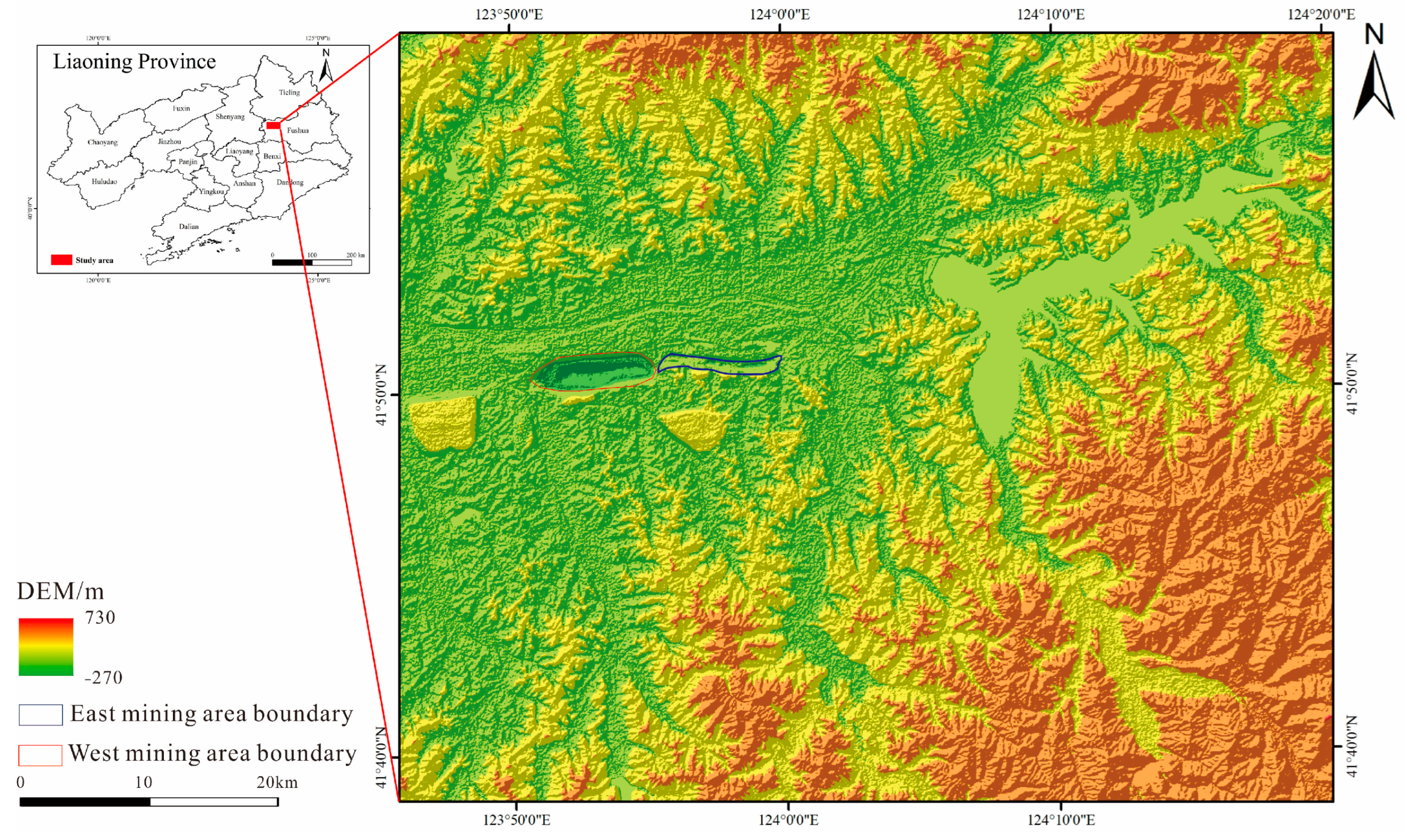
2.1. Study Area
2.2. Data Sources
2.3. Research Methods
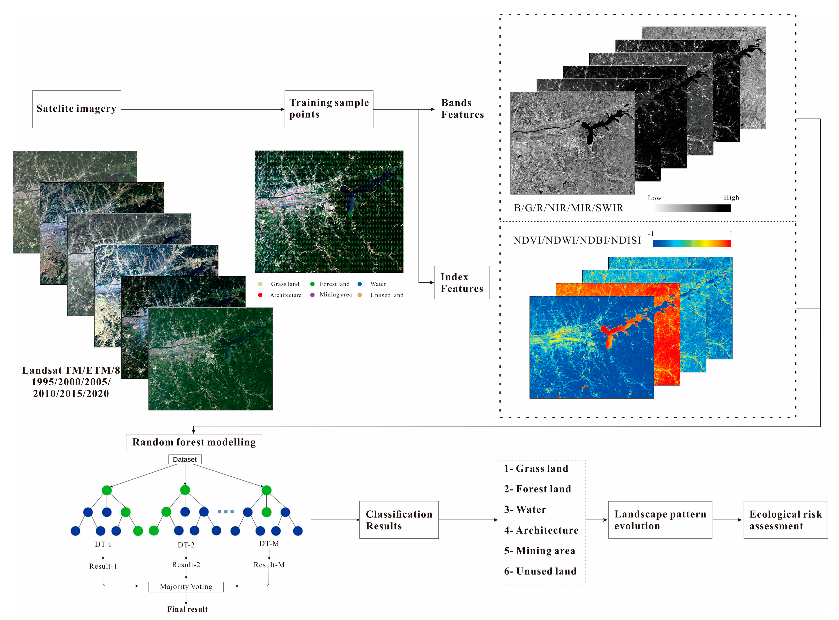
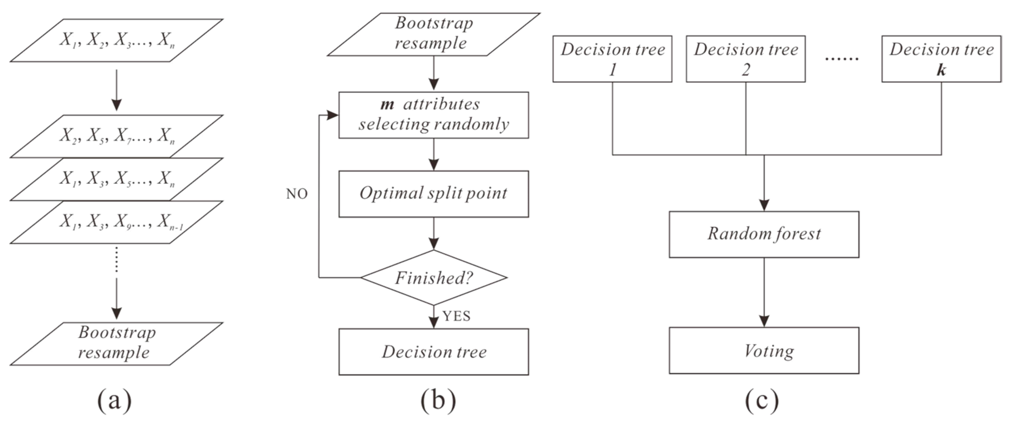
2.3.1. Random Forest Classification Method
- (1)
- RF algorithm
- (2)
- Predictor establishment
- (3)
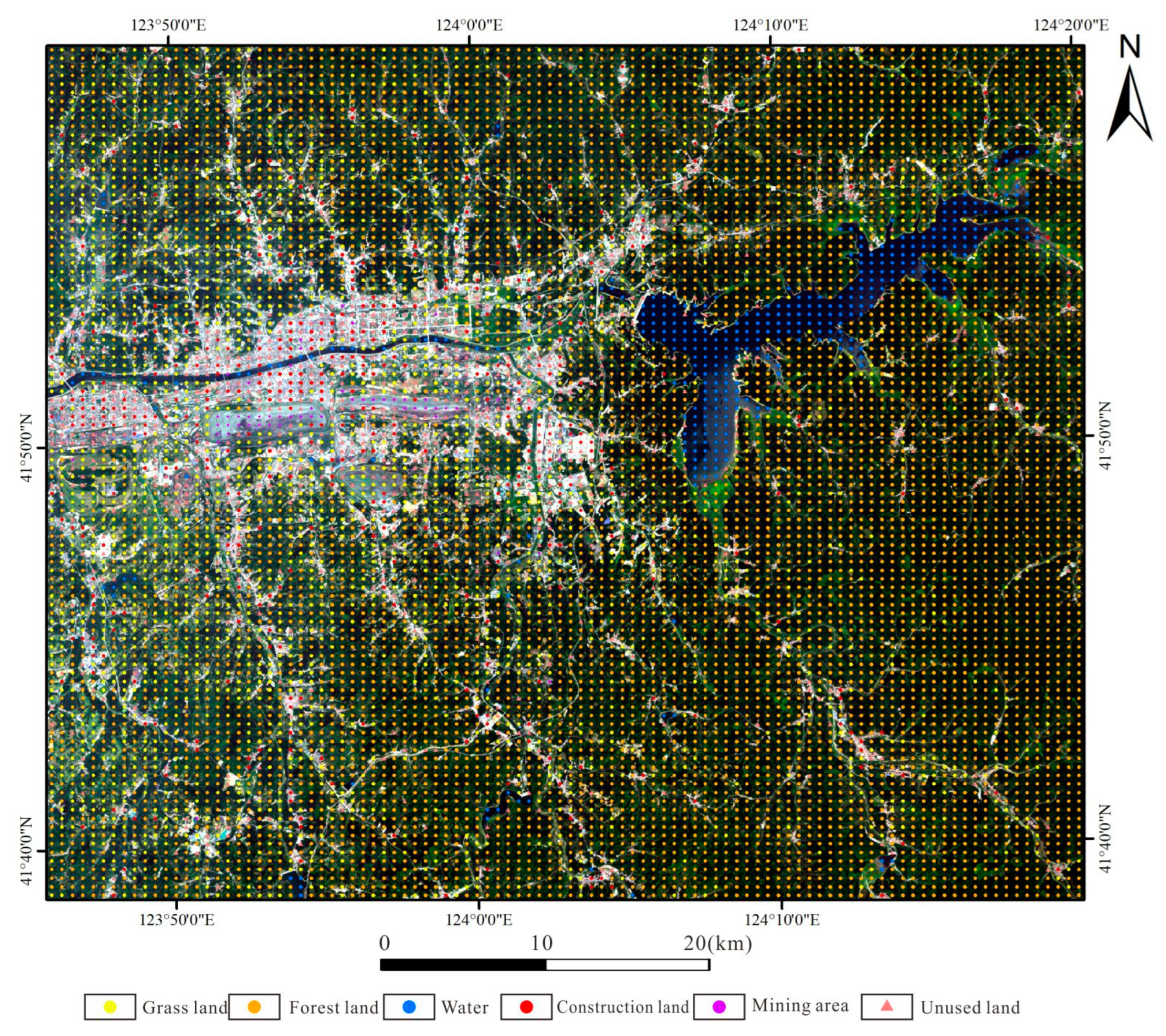
- Training data
2.3.2. Landscape Analysis Method
2.3.3. Landscape Ecological Risk Index
3. Results
3.1. RF-Based Classification Results
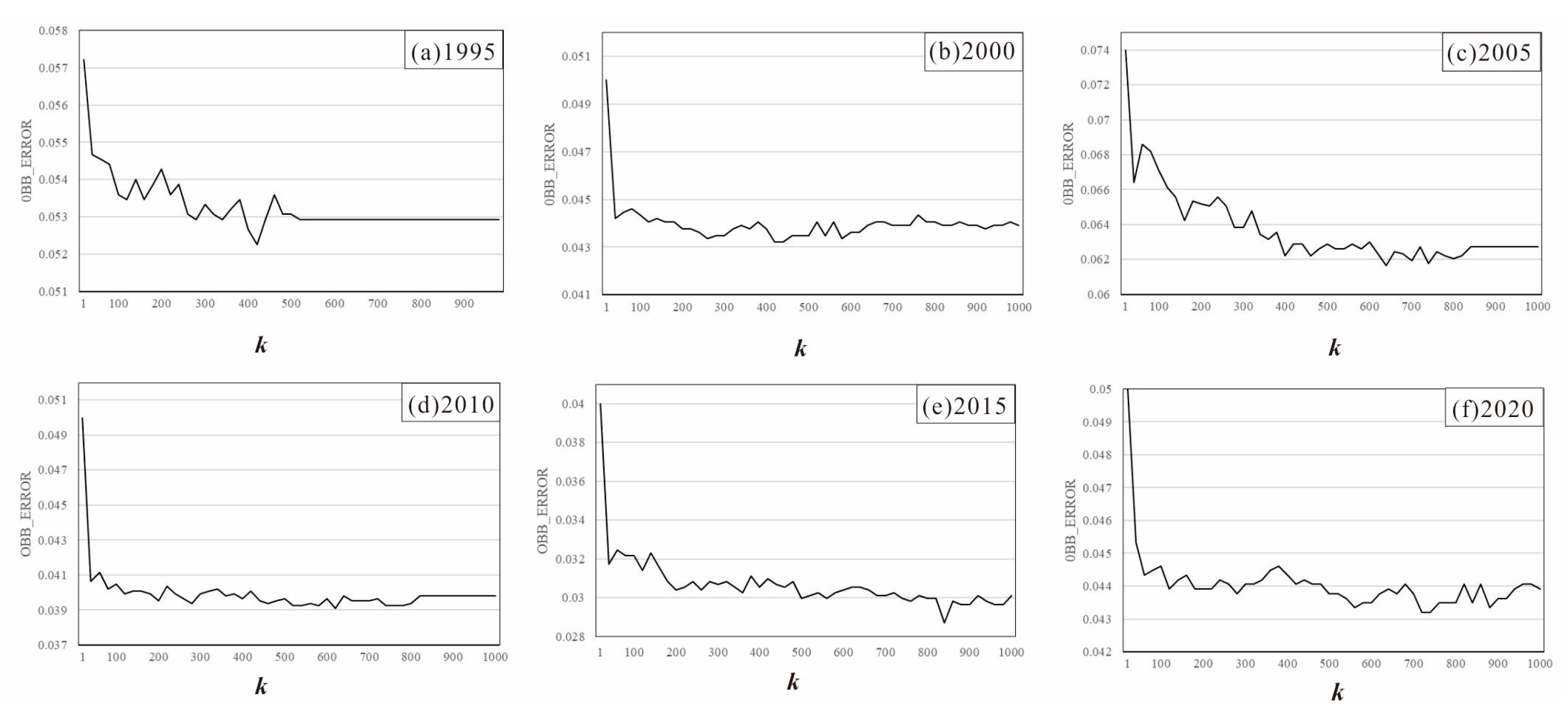
3.1.1. Optimal Model Parameter Training
3.1.2. Classification Results of Ground Objects
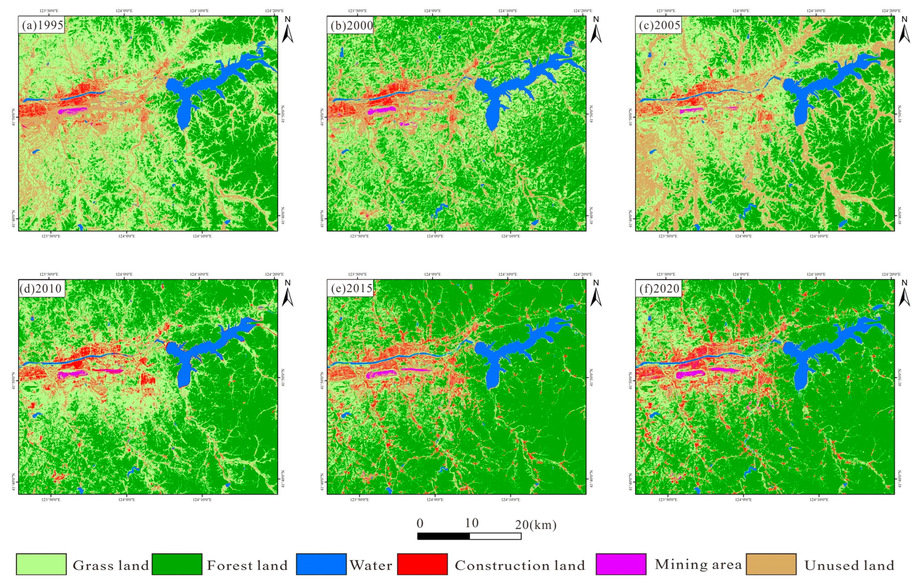
3.2. Temporal and Spatial Changes of Land Use Cover
3.3. Landscape Pattern Evolution Analysis
3.3.1. Type Level
3.3.2. Landscape Level
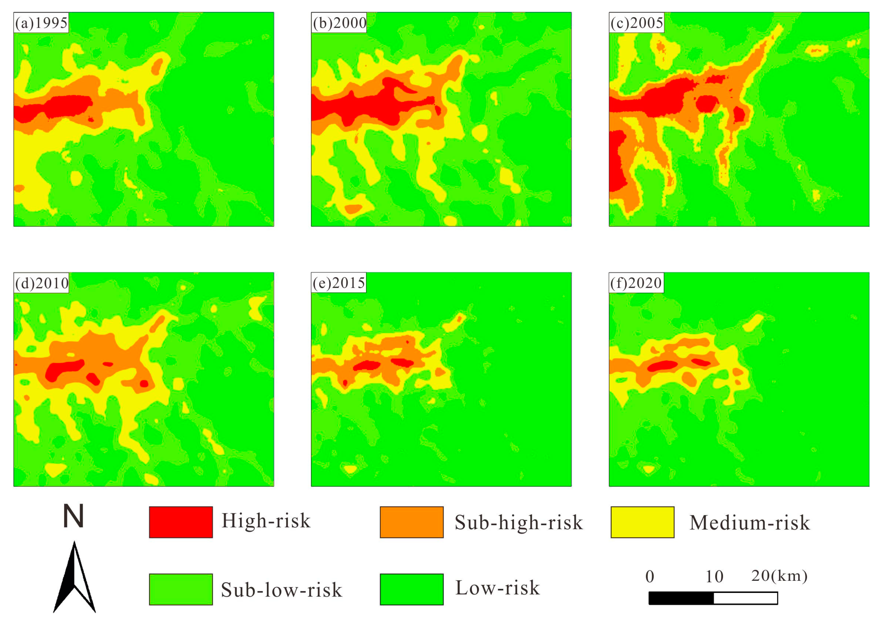
3.4. Ecological Risk Analysis
4. Discussion
4.1. Exploration of Methods and Results of Land-Use Type Classification
4.2. Exploration of Ecological Risk Assessment Results and Applicability
4.3. Limitations of this Study and Future Work
5. Conclusions
- (1)
- The method of the equidistant establishment of interpretation sampling points to construct a training set combined with the random forest model and multi-quantitative remote sensing index method proposed in this paper can accurately and efficiently achieve the classification of LULC in open-pit mining areas. This approach has high precision and accuracy (the accuracy in this study is 92–97%), which can provide technical reference for dynamic monitoring of other open-pit mines.
- (2)
- The land cover changes in the study area encompass two main trends. During the period from 1995 to 2005, changes in vegetation, buildings, bare soil, and other land types were relatively stable. From 2010 to 2020, the vegetation coverage and building land coverage increased significantly. By 2010, the degree of vegetation coverage increased significantly, mainly from a decrease in unused land. In 2015, construction land expanded radially from the mining area to the surrounding area, mainly from unused land. Our results shows that the land use around the study area has been greatly improved, which is closely related to a series of ecological and environmental protection plans by the Chinese government.
- (3)
- The overall ecological risk index of the study area is characterized by an increase from 1995 to 2005 and a decrease from 2010 to 2020. In 2015, the high-risk area and the low-risk area showed a cliff-like increase and decrease, respectively. In 2020, mid-year, the high ecological risk areas were lower than in 1995. It is generally believed that the landscape pattern and ecological environment of the study area have been greatly improved. The ecological risk in the study area is generally reduced, and the next governance direction should focus on the open-pit mining area and surrounding construction land.
Author Contributions
Funding
Institutional Review Board Statement
Informed Consent Statement
Data Availability Statement
Acknowledgments
Conflicts of Interest
References
- Deng, R.; Ding, X.; Wang, J. Landscape ecological risk assessment and spatial pattern evolution analysis of the Central Yunnan Urban Agglomeration from 1995 to 2020 based on land use/cover change. Sustainability 2023, 15, 16641. [Google Scholar] [CrossRef]
- Wu, Z.; Lei, S.; Lu, Q.; Bian, Z. Impacts of large-scale open-pit coal base on the landscape ecological health of semi-arid grasslands. Remote Sens. 2019, 11, 1820. [Google Scholar] [CrossRef]
- Zhan, T.; Bao, L.; Zhang, W. Dynamic monitoring of landscape in Huolinhe South Open-pit Mine based on GIS. Grass Prataculture 2017, 29. [Google Scholar]
- Su, S.; Xiao, R.; Jiang, Z.; Zhang, Y. Characterizing landscape pattern and ecosystem service value changes for urbanization impacts at an eco-regional scale. Appl. Geogr. 2012, 34, 295–305. [Google Scholar] [CrossRef]
- Zhou, K.; Yang, Y.; Zhang, Y.; Miao, R.; Yang, Y.; Yang, L. Review of Land Use Classification Methods Based on Optical Remote Sensing Images. Sci. Technol. Eng. 2021, 21, 13603–13613. [Google Scholar]
- Cracknell, M.J.; Reading, A.M. The upside of uncertainty: Identification of lithology contact zones from airborne geophysics and satellite data using random forests and support vector machines. Geophysics 2013, 78, WB113–WB126. [Google Scholar] [CrossRef]
- Yao, J.; Wu, J.; Xiao, C.; Zhang, Z.; Li, J. The Classification Method Study of Crops Remote Sensing with Deep Learning, Machine Learning, and Google Earth Engine. Remote Sens. 2022, 14, 2758. [Google Scholar] [CrossRef]
- Hou, M.; Ge, J.; Gao, J.; Meng, B.; Li, Y.; Yin, J.; Liu, J.; Feng, Q.; Liang, T. Ecological risk assessment and impact factor analysis of alpine wetland ecosystem based on LUCC and boosted regression tree on the Zoige Plateau, China. Remote Sens. 2020, 12, 368. [Google Scholar] [CrossRef]
- Tian, J.; Shen, C.; Wang, B.; Xia, X.; Zhang, M.; Lin, C.; Li, Q. LESSON: Multi-Label Adversarial False Data Injection Attack for Deep Learning Locational Detection. IEEE Trans. Dependable Secur. Comput. 2024, 1–15. [Google Scholar] [CrossRef]
- Zhang, Q.; Chen, J.; Xu, H.; Jia, Y.; Chen, X.; Jia, Z.; Liu, H. Three-Dimensional Mineral Prospectivity Mapping by XGBoost Modeling: A Case Study of the Lannigou Gold Deposit, China. Nat. Resour. Res. 2022, 31, 1135–1156. [Google Scholar] [CrossRef]
- Liu, D.; Li, X.; Li, X.; Yang, G.; Yang, J. Analysis of the potential of GF-6 WFV data for forest and non-forest land identification. Bull. Surv. Mapp. 2020, 8, 5–12. [Google Scholar]
- Sun, N.; Zhao, X.; Mu, B.; Zhao, J.; Liu, N. Research on Land Cover Classification Method Combined with Fractional Vegetation Cover. J. Beijing Norm. Univ. (Nat. Sci.) 2022, 58, 917–925. [Google Scholar]
- Wang, L.; Kong, Y.; Yang, X.; Xu, Y.; Liang, L.; Wang, S. Classification of land use in farming areas based on feature optimization random forest algorithm. Trans. Chin. Soc. Agric. Eng. 2020, 36, 244–250. [Google Scholar]
- Wang, F.; Wang, D.; Zhang, L.; Liu, J.; Hu, B.; Sun, Z.; Chen, J. Spatiotemporal analysis of the dynamic changes in land use ecological risks in the urban agglomeration of Beijing-Tianjin-Hebei vegion. Acta Ecol. Sin. 2018, 38, 4307–4316. [Google Scholar]
- He, S.; Li, X.; He, C.; Fang, B. Landscape Ecological Risk Assessment in Guangling District of Yangzhou City Based on Land Use Change. J. Nanjing Norm. Univ. (Nat. Sci. Ed.) 2019, 42, 139–148. [Google Scholar]
- Wang, P.; Wang, Y.; Liu, X.; Chen, X.; Kong, F. Ecological risk assessment of an ecological migrant resettlement region based on landscape structure: A case study of Hongsibu in Ningxia. Acta Ecol. Sin. 2018, 38, 2672–2682. [Google Scholar]
- Sun, Q.; Bai, Z.; Cao, Y.; Xie, M.; Hu, X.; Jiang, Y.; Lu, Y. Ecological risk assessment of land destruction in large open-pit mine. Trans. Chin. Soc. Agric. Eng. 2015, 31, 278–288. [Google Scholar]
- Zeng, H.; Hu, Z.; Xie, H. Research on LUCC information atlas based on multi-temporal remote sensing in coal mining area. J. Liaoning Tech. Univ. 2007, 26, 626–629. [Google Scholar]
- Yan, X.; Su, X.; Wang, Y.; Yu, Z.; Liang, S. Study on Changes of Landscape Pattern in Central District of Zunyi City. J. Southwest For. Univ. 2020, 40, 135–142. [Google Scholar]
- Wu, S.; Wei, J.; He, Z.; Dong, S.; Shi, X. Research progress in ecological risk assessment of mining cities. Saf. Environ. Eng. 2022, 29, 207–217. [Google Scholar]
- Song, L.; Bai, Z. A case study on ordos city: Ecological risk assessment and prediciton in coal city. Resour. Ind. 2017, 19, 15. [Google Scholar]
- Zhang, Y.; Li, Y.; Lv, J.; Wang, J.; Wu, Y. Scenario simulation of ecological risk based on land use/cover change—A case study of the Jinghe county, China. Ecol. Indic. 2021, 131, 108176. [Google Scholar] [CrossRef]
- Lin, X.; Wang, Z. Landscape ecological risk assessment and its driving factors of multi-mountainous city. Ecol. Indic. 2023, 146, 109823. [Google Scholar] [CrossRef]
- Xu, W.; Wang, J.; Zhang, M.; Li, S. Construction of landscape ecological network based on landscape ecological risk assessment in a large-scale opencast coal mine area. J. Clean. Prod. 2021, 286, 125523. [Google Scholar] [CrossRef]
- Wang, W.; Liu, R.; Gan, F.; Zhou, P.; Zhang, X.; Ding, L. Monitoring and evaluating restoration vegetation status in mine region using remote sensing data: Case study in inner Mongolia, China. Remote Sens. 2021, 13, 1350. [Google Scholar] [CrossRef]
- Yagmur, N.; Erten, E.; Musaoglu, N.; Safak, E. Assessing Spatio-temporal Dynamics of Large Airport’s Surface Stability. Geocarto Int. 2022, 37, 13734–13747. [Google Scholar] [CrossRef]
- Xia, Z.; Xie, Y.; Wang, T. Land use and spatial and temporal change of normalized difference vegetation index (NDVI) in Shenfu Mining area and their driving factors analysis. Chin. Agric. Sci. Bull. 2021, 37. [Google Scholar]
- Lin, X.; Xu, M.; Cao, C.; Singh, R.P.; Chen, W.; Ju, H. Land-use/land-cover changes and their influence on the ecosystem in Chengdu City, China during the period of 1992–2018. Sustainability 2018, 10, 3580. [Google Scholar] [CrossRef]
- Li, X.; Lei, S.; Liu, Y.; Chen, H.; Zhao, Y.; Gong, C.; Bian, Z.; Lu, X. Evaluation of Ecological Stability in Semi-Arid Open-Pit Coal Mining Area Based on Structure and Function Coupling during 2002–2017. Remote Sens. 2021, 13, 5040. [Google Scholar] [CrossRef]
- Kang, S.; Niu, J.; Zhang, Q.; Han, Y.; Dong, J.; Zhang, J. Impacts of mining on landscape pattern and primary productivity in the grassland of Inner Mongolia: A case study of Heidaigou open pit coal mining. Acta Ecol. Sin. 2014, 34, 2855–2867. [Google Scholar]
- Guo, C.; Liu, Y.; Li, H.; Sun, Y.; Yu, Y. Landscape Characteristics and Construction of Landscape Ecological Security Pattern in West Open Pit of Fushun Mine. J. Shenyang Agric. Univ. 2021, 52, 442–450. [Google Scholar]
- Jin, P.; Shen, L.; Han, X.; Guo, J.; Wang, M. Spatial-temporal distribution characteristics and influencing factors of geological disasters in the open-pit mining area of western Fushun, Liaoning Province. Chin. J. Geol. Hazard Control. 2022, 33, 68–76. [Google Scholar]
- Feng, D.; Wang, J. Study on public emergency safety evacuation behavior of sudden geological disaster in open-pit mining area-taking Fushun west open-pit mining area as an example. J. Saf. Sci. Technol. 2022, 18, 132–138. [Google Scholar]
- Zhang, X.; Teng, C.; Ren, L.; Sun, L.; Wang, L.; Cui, Y. Characteristics and stability assessment of south landslide in Fushun west open pit mine. J. Liaoning Tech. Univ. (Nat. Sci.) 2015, 34, 305–309. [Google Scholar]
- Xiao, P.; Chen, H.; Feng, P.; Li, H.; Yan, X.; Xu, Y. Study on the relationship between plant community diversity and soil physicochemical properties in Fushun West Open-pit mining area. Opencast Min. Technol. 2021, 36, 5–8. [Google Scholar]
- Peng, J.; Dang, W.; Liu, Y.; Zong, M.; Hu, X. Review on landscape ecological risk assessment. Acta Geogr. Sin. 2015, 70, 664. [Google Scholar]
- Wang, Q.; Tenhunen, J.; Dinh, N.Q.; Reichstein, M.; Vesala, T.; Keronen, P. Similarities in ground-and satellite-based NDVI time series and their relationship to physiological activity of a Scots pine forest in Finland. Remote Sens. Environ. 2004, 93, 225–237. [Google Scholar] [CrossRef]
- Carlson, T.N.; Ripley, D.A. On the relation between NDVI, fractional vegetation cover, and leaf area index. Remote Sens. Environ. 1997, 62, 241–252. [Google Scholar] [CrossRef]
- Kalabin, G. Qualitative assessment of vegetation in disturbed mining-and-metallurgical areas by the remote and surface monitoring. J. Min. Sci. 2011, 47, 538–546. [Google Scholar] [CrossRef]
- Ma, W.; Ma, C.; Zhao, P.; Liu, W. Variation Trend and Climate Response of NDVI3g in Lu’an Mining Area from 1982 to 2013. Res. Environ. Sci 2017, 30, 1050–1058. [Google Scholar]
- Bazzi, H.; Baghdadi, N.; Ienco, D.; El Hajj, M.; Zribi, M.; Belhouchette, H.; Escorihuela, M.J.; Demarez, V. Mapping irrigated areas using Sentinel-1 time series in Catalonia, Spain. Remote Sens. 2019, 11, 1836. [Google Scholar] [CrossRef]
- Wang, X.; Luo, L. From remote sensing archaeology to space archaeology: A new task in the era of cultural heritage protection. J. Remote Sens. 2020, 24, 837–841. [Google Scholar] [CrossRef]
- Chen, Z.; Chang, R.; Zhao, W.; Li, S.; Guo, H.; Xiao, K.; Wu, L.; Hou, D.; Zou, L. Quantitative prediction and evaluation of geothermal resource areas in the southwest section of the Mid-Spine Belt of Beautiful China. Int. J. Digit. Earth 2022, 15, 748–769. [Google Scholar] [CrossRef]
- Liu, Y.; Xu, W.; Hong, Z.; Wang, L.; Ou, G.; Lu, N. Assessment of Spatial-Temporal Changes of Landscape Ecological Risk in Xishuangbanna, China from 1990 to 2019. Sustainability 2022, 14, 10645. [Google Scholar] [CrossRef]
- Zhao, Y.; Li, Y.; Shao, J. Ecological Risk Assessment of Small Watershed of the Three Gorges Reservoir Area Based on Land Use Change—A Case Study of Caotang River. J. Nat. Resour. 2013, 28, 944–956. [Google Scholar]
- Cavallero, L.; Lopez, D.R.; Raffaele, E.; Aizen, M.A. Structural–functional approach to identify post-disturbance recovery indicators in forests from northwestern Patagonia: A tool to prevent state transitions. Ecol. Indic. 2015, 52, 85–95. [Google Scholar] [CrossRef]
- Breiman, L. Bagging predictors. Mach. Learn. 1996, 24, 123–140. [Google Scholar] [CrossRef]
- Breiman, L. Random forests. Mach. Learn. 2001, 45, 5–32. [Google Scholar] [CrossRef]
- Breiman, L.; Friedman, J.H.; Olshen, R.A.; Stone, C.J. Classification and Regression Trees; Routledge: Oxfordshire, UK, 2017. [Google Scholar]
- Chen, J.; Mao, X.; Liu, Z.; Deng, H. Three-dimensional Metallogenic Prediction Based on Random Forest Classification Algorithm for the Dayingezhuang Gold Deposit. Geotecton. Metallog. 2020, 44, 231–241. [Google Scholar] [CrossRef]
- Brück, Y.; Overberg, P.; Pohle, I.; Hinz, C. NDVI (Normalized Difference Vegetation Index) signatures of transient ecohydrological systems: The case of post-mining landscapes. In Proceedings of the EGU General Assembly, Vienna, Austria, 23–28 April 2017; p. 5353. [Google Scholar]
- Guha, S.; Govil, H.; Taloor, A.K.; Gill, N.; Dey, A. Land surface temperature and spectral indices: A seasonal study of Raipur City. Geod. Geodyn. 2022, 13, 72–82. [Google Scholar] [CrossRef]
- Zeng, L.; Hang, J.; Wang, X.; Shao, M. Influence of urban spatial and socioeconomic parameters on PM2.5 at subdistrict level: A land use regression study in Shenzhen, China. J. Environ. Sci. 2022, 114, 485–502. [Google Scholar] [CrossRef] [PubMed]
- Huang, F.; Liu, Z.; Xie, T.; He, Y. A NDISI-based Double-Differenced Remote Sensing Index with Composite-Weights for Impervious Surface Information Estimation. J. Geo-Inf. Sci. 2021, 23, 1850–1860. [Google Scholar]
- Pedregosa, F.; Varoquaux, G.; Gramfort, A.; Michel, V.; Thirion, B.; Grisel, O.; Blondel, M.; Prettenhofer, P.; Weiss, R.; Dubourg, V. Scikit-learn: Machine learning in Python. J. Mach. Learn. Res. 2011, 12, 2825–2830. [Google Scholar]
- Huang, X.; Xiao, J.; Ma, M. Evaluating the Performance of Satellite-Derived Vegetation Indices for Estimating Gross Primary Productivity Using FLUXNET Observations across the Globe. Remote Sens. 2019, 11, 1823. [Google Scholar] [CrossRef]
- Fan, C.; Myint, S. A comparison of spatial autocorrelation indices and landscape metrics in measuring urban landscape fragmentation. Landsc. Urban Plan. 2014, 121, 117–128. [Google Scholar] [CrossRef]
- Li, J.; Lu, Y.; Li, X.; Wang, R.; Sun, Y.; Liu, Y.; Yao, K. Evaluation and Analysis of Development Status of Yellow River Beach Area Based on Multi-Source Data and Coordination Degree Model. Sustainability 2023, 15, 6086. [Google Scholar] [CrossRef]
- Mingming Ji, H.S. The change of marsh landscape pattern in Zhenlai county during 1980 to 2018 and the effects due to humandisturbance. J. Zhejiang Univ. (Sci. Ed.) 2021, 48, 760–770. [Google Scholar]
- Zhang, X.; Shi, P.; Luo, J. Landscape ecological risk assessment of the Shiyang River Basin. In Proceedings of the International Conference on Geo-Informatics in Resource Management and Sustainable Ecosystem, Wuhan, China, 8–10 November 2013; pp. 98–106. [Google Scholar]
- Wang, D.; Chai, H.; Wang, Z.; Wang, K.; Wang, H.; Long, H.; Gao, J.; Wei, A.; Wang, S. Dynamic Monitoring and Ecological Risk Analysis of Lake Inundation Areas in Tibetan Plateau. Sustainability 2022, 14, 13332. [Google Scholar] [CrossRef]
- O’neill, R.; Hunsaker, C.; Timmins, S.P.; Jackson, B.; Jones, K.; Riitters, K.H.; Wickham, J.D. Scale problems in reporting landscape pattern at the regional scale. Landsc. Ecol. 1996, 11, 169–180. [Google Scholar] [CrossRef]
- Liu, D.D.; Qu, R.J.; Zhao, C.H.; Liu, A.P.; Deng, X.Z. Landscape ecological risk assessment in Yellow River Delta. J. Food Agric. Environ. 2012, 10, 970–972. [Google Scholar]
- Meng, B.; Yang, Z.; Yu, H.; Qin, Y.; Sun, Y.; Zhang, J.; Chen, J.; Wang, Z.; Zhang, W.; Li, M. Mapping of kobresia pygmaea community based on umanned aerial vehicle technology and gaofen remote sensing data in alpine meadow grassland: A case study in eastern of Qinghai–Tibetan Plateau. Remote Sens. 2021, 13, 2483. [Google Scholar] [CrossRef]
- Shi, H.; Yang, Z.; Han, F.; Shi, T.; Li, D. Assessing Landscape Ecological Risk for a World Natural Heritage Site: A Case Study of Bayanbulak in China. Pol. J. Environ. Stud. 2015, 24. [Google Scholar] [CrossRef] [PubMed]
- Vidal Macua, J.J.; Nicolau, J.M.; Vicente, E.; Moreno-de Las Heras, M. Assessing vegetation recovery in reclaimed opencast mines of the Teruel coalfield (Spain) using Landsat time series and boosted regression trees. Sci. Total Environ. 2020, 717, 137250. [Google Scholar] [CrossRef]
- Omar, H.; Cabral, P. Ecological risk assessment based on land cover changes: A case of Zanzibar (Tanzania). Remote Sens. 2020, 12, 3114. [Google Scholar] [CrossRef]
- Truong, X.Q.; Dang, N.H.D.; Do, T.H.; Tran, N.D.; Do, T.T.N.; Tran, V.A.; Yordanov, V.; Brovelli, M.A.; Khuc, T.D. Random forest analysis of land use and land cover change using sentinel-2 data in van yen, yen bai province, vietnam. In Proceedings of the International Conference on Geo-Spatial Technologies and Earth Resources, Hanoi, Vietnam, 13–14 October 2022; pp. 429–445. [Google Scholar]
- Mao, W.; Lu, D.; Hou, L.; Liu, X.; Yue, W. Comparison of machine-learning methods for urban land-use mapping in Hangzhou city, China. Remote Sens. 2020, 12, 2817. [Google Scholar] [CrossRef]
- Wang, S.; Guo, J.; Yu, Y.; Shi, P.; Zhang, H. Quality evaluation of land reclamation in mining area based on remote sensing. Int. J. Coal Sci. Technol. 2023, 10, 43. [Google Scholar] [CrossRef]
- Wang, H.; Zhou, W.; Guan, Y.; Wang, J.; Ma, R. Monitoring the ecological restoration effect of land reclamation in open-pit coal mining areas: An exploration of a fusion method based on ZhuHai-1 and Landsat 8 data. Sci. Total Environ. 2023, 904, 166324. [Google Scholar] [CrossRef] [PubMed]


| Type | NDVI | NDWI | NDISI | NDBI | b1 | b2 | b3 | b4 | b5 | b6 |
|---|---|---|---|---|---|---|---|---|---|---|
| 1 | 0.584135 | −0.64032 | −0.29876 | −0.22434 | 381 | 578 | 692 | 2636 | 1670 | 879 |
| 1 | 0.542924 | −0.60207 | −0.1671 | −0.11805 | 454 | 654 | 780 | 2633 | 2077 | 1276 |
| 2 | 0.722332 | −0.68164 | −0.51319 | −0.44637 | 305 | 411 | 350 | 2171 | 831 | 366 |
| 2 | 0.716343 | −0.68729 | −0.41997 | −0.30992 | 337 | 508 | 453 | 2741 | 1444 | 639 |
| 3 | −0.05752 | 0.159763 | −0.28824 | −0.31077 | 207 | 294 | 239 | 213 | 112 | 114 |
| 3 | −0.07042 | 0.106767 | −0.43947 | −0.53488 | 204 | 368 | 342 | 297 | 90 | 98 |
| 4 | 0.139021 | −0.3472 | 0.056139 | 0.07168 | 692 | 957 | 1213 | 1975 | 2280 | 1944 |
| 4 | 0.118249 | −0.48795 | −0.03852 | −0.04796 | 599 | 797 | 950 | 2316 | 2104 | 1610 |
| 5 | 0.196325 | −0.36039 | −0.00138 | 0.052072 | 523 | 796 | 919 | 1693 | 1879 | 1452 |
| 5 | 0.176895 | −0.24164 | 0.056169 | 0.02004 | 657 | 896 | 1026 | 1467 | 1527 | 1451 |
| 6 | 0.047214 | −0.52 | −0.05496 | −0.03754 | 446 | 816 | 987 | 2584 | 2397 | 1731 |
| 6 | 0.189973 | −0.53352 | −0.10072 | −0.04629 | 526 | 856 | 1235 | 2814 | 2565 | 1698 |
| …… | …… | …… | ||||||||
| Landscape Pattern Index | Calculation Formula | Formula Description |
|---|---|---|
| Landscape fragmentation index (Ci) | is the number of patches of landscape ; is the total area of landscape | |
| Landscape separation index (Si) | is the total landscape area | |
| Landscape dominance index (Ki) | is the quadrat number of landscape type patches, is the total quadrat number, and is the total number of patches | |
| Landscape disturbance index (Ui) | Indicates the impact of each index on the value of landscape ecological services, a + b + c = 1, and here, a = 0.5, b = 0.3, c = 0.2 | |
| Landscape vulnerability index (Vi) | Drawing on relevant research in mining areas and combining the characteristics of risk sources, the land type and vulnerability are linked, and the vulnerability is divided into 6 levels | Unused land = 6, Grass land = 5, Water = 4, Forest land = 3, Mining area = 2, Architecture = 1 |
| Landscape loss index (Ri) | and are the disturbance index and vulnerability index of landscape , respectively |
| Year | max_features (m) | n_estimators (k) | Obb_error | Overall_accuracy |
|---|---|---|---|---|
| 2020 | 4 | 720 | 0.043209008 | 0.956790992 |
| 2018 | 3 | 840 | 0.028688777 | 0.971311223 |
| 2015 | 8 | 610 | 0.039110745 | 0.960889255 |
| 2011 | 4 | 450 | 0.043209008 | 0.956790992 |
| 2007 | 3 | 650 | 0.061650552 | 0.938349448 |
| 2002 | 3 | 425 | 0.052264808 | 0.947735192 |
| Land Use | 1995 | 2000 | 2005 | 2010 | 2015 | 2020 | ||||||
|---|---|---|---|---|---|---|---|---|---|---|---|---|
| Area/km2 | % | Area/km2 | % | Area/km2 | % | Area/km2 | % | Area/km2 | % | Area/km2 | % | |
| Grass land | 862.1 | 46.2 | 738.1 | 39.6 | 689.5 | 37.0 | 643.5 | 34.5 | 398.3 | 21.4 | 398.1 | 22.1 |
| Forest land | 558.6 | 29.9 | 753.2 | 40.4 | 650.8 | 34.9 | 961.1 | 51.5 | 1178.1 | 63.2 | 1179.7 | 62.5 |
| Water | 63.6 | 3.4 | 70.2 | 3.8 | 59.3 | 3.2 | 56.7 | 3.0 | 61.3 | 3.3 | 67.2 | 3.6 |
| Construction land | 26.8 | 1.4 | 27.0 | 1.4 | 26.9 | 1.4 | 50.2 | 2.7 | 79.9 | 4.3 | 85.8 | 4.6 |
| Mining area | 4.0 | 0.2 | 5.7 | 0.3 | 4.0 | 0.2 | 5.1 | 0.3 | 5.8 | 0.3 | 6.5 | 0.4 |
| Unused land | 350.6 | 18.8 | 271.4 | 14.6 | 435.0 | 23.3 | 149.0 | 8.0 | 142.1 | 7.6 | 128.4 | 6.9 |
| Landscape Index | Year | Grass Land | Forest Land | Water | Construction Land | Mining Area | Unused Land |
|---|---|---|---|---|---|---|---|
| Patch area (PA)/km2 | 1995 | 862.0758 | 558.5715 | 63.6219 | 26.6598 | 4.0428 | 350.64 |
| 2000 | 738.0702 | 753.1947 | 70.2153 | 26.9748 | 5.7024 | 271.4544 | |
| 2005 | 689.5719 | 650.8053 | 59.3145 | 26.8758 | 4.0176 | 435.0267 | |
| 2010 | 643.5234 | 961.0929 | 56.6694 | 50.247 | 5.0859 | 148.9932 | |
| 2015 | 398.3229 | 1178.1477 | 61.2765 | 79.9452 | 5.8437 | 142.0758 | |
| 2020 | 398.1393 | 1179.6534 | 67.1652 | 85.7817 | 6.4944 | 128.3778 | |
| Patch density (PD) | 1995 | 5.3178 | 6.1444 | 0.1072 | 2.419 | 0.3452 | 6.221 |
| 2000 | 7.7996 | 6.571 | 0.1528 | 1.7565 | 0.2074 | 5.7965 | |
| 2005 | 5.2621 | 3.066 | 0.1463 | 3.0167 | 0.1303 | 4.911 | |
| 2010 | 6.6954 | 4.5406 | 0.1844 | 2.8773 | 0.1801 | 5.0043 | |
| 2015 | 7.7631 | 3.2413 | 0.3259 | 5.4352 | 0.9107 | 7.0695 | |
| 2020 | 9.0308 | 3.6369 | 0.2321 | 6.1358 | 0.4176 | 7.009 | |
| Largest patch index (LPI) | 1995 | 16.6371 | 7.4525 | 3.0135 | 0.1751 | 0.1559 | 10.7358 |
| 2000 | 4.5866 | 5.9877 | 3.1722 | 0.1897 | 0.1809 | 8.5946 | |
| 2005 | 14.8271 | 7.9614 | 2.6333 | 0.1899 | 0.0769 | 5.5252 | |
| 2010 | 17.7092 | 12.7109 | 2.4737 | 0.211 | 0.1514 | 1.6487 | |
| 2015 | 5.9317 | 23.7637 | 2.6377 | 0.3212 | 0.1274 | 1.4199 | |
| 2020 | 4.533 | 24.9531 | 2.8278 | 0.3216 | 0.2008 | 0.6174 | |
| Patch shape index (PSI) | 1995 | 180.4106 | 127.191 | 12.0808 | 82.1652 | 21.6444 | 150.9367 |
| 2000 | 232.1645 | 170.6306 | 13.4687 | 73.9914 | 16.5562 | 140.2393 | |
| 2005 | 190.1148 | 92.7431 | 13.1954 | 89.4538 | 15.43 | 146.4098 | |
| 2010 | 197.4249 | 117.0503 | 12.0757 | 87.3467 | 18.2318 | 158.0393 | |
| 2015 | 234.3494 | 96.0826 | 13.2778 | 146.5678 | 22.5247 | 168.3258 | |
| 2020 | 215.0102 | 89.856 | 15.3949 | 138.5405 | 36.8243 | 169.4496 |
| Year | CONTAG | DIVISION | SHDI | SHEI |
|---|---|---|---|---|
| 1995 | 48.1628 | 99.6718 | 0.9274 | 1.2212 |
| 2000 | 48.8063 | 99.3558 | 0.975 | 1.2159 |
| 2005 | 49.7651 | 99.5941 | 0.9531 | 1.2558 |
| 2010 | 53.5956 | 99.619 | 0.9359 | 1.1303 |
| 2015 | 54.1648 | 99.1954 | 0.9283 | 1.1169 |
| 2020 | 54.9521 | 99.2635 | 0.9223 | 1.0813 |
| Ecological Risk | Low Risk | Sub-Low Risk | Mediumrisk | Sub-High Risk | High Risk | 2020 |
|---|---|---|---|---|---|---|
| Low risk | 752.87 | 467.19 | 28.82 | 0.11 | 0.00 | 1249.00 |
| Sub-low risk | 34.29 | 192.85 | 154.64 | 20.81 | 2.59 | 405.18 |
| Medium risk | 0.00 | 4.73 | 64.04 | 56.44 | 6.30 | 131.49 |
| Sub-high risk | 0.00 | 0.05 | 10.69 | 30.62 | 28.13 | 69.48 |
| High risk | 0.00 | 0.00 | 0.00 | 3.80 | 6.66 | 10.46 |
| 1995 | 787.16 | 664.81 | 258.19 | 111.78 | 43.67 |
Disclaimer/Publisher’s Note: The statements, opinions and data contained in all publications are solely those of the individual author(s) and contributor(s) and not of MDPI and/or the editor(s). MDPI and/or the editor(s) disclaim responsibility for any injury to people or property resulting from any ideas, methods, instructions or products referred to in the content. |
© 2024 by the authors. Licensee MDPI, Basel, Switzerland. This article is an open access article distributed under the terms and conditions of the Creative Commons Attribution (CC BY) license (https://creativecommons.org/licenses/by/4.0/).
Share and Cite
Xu, H.; Cheng, W. Landscape Analysis and Ecological Risk Assessment during 1995–2020 Based on Land Utilization/Land Coverage (LULC) and Random Forest: A Case Study of the Fushun Open-Pit Coal Area in Liaoning, China. Sustainability 2024, 16, 2442. https://doi.org/10.3390/su16062442
Xu H, Cheng W. Landscape Analysis and Ecological Risk Assessment during 1995–2020 Based on Land Utilization/Land Coverage (LULC) and Random Forest: A Case Study of the Fushun Open-Pit Coal Area in Liaoning, China. Sustainability. 2024; 16(6):2442. https://doi.org/10.3390/su16062442
Chicago/Turabian StyleXu, Hua, and Weiming Cheng. 2024. "Landscape Analysis and Ecological Risk Assessment during 1995–2020 Based on Land Utilization/Land Coverage (LULC) and Random Forest: A Case Study of the Fushun Open-Pit Coal Area in Liaoning, China" Sustainability 16, no. 6: 2442. https://doi.org/10.3390/su16062442
APA StyleXu, H., & Cheng, W. (2024). Landscape Analysis and Ecological Risk Assessment during 1995–2020 Based on Land Utilization/Land Coverage (LULC) and Random Forest: A Case Study of the Fushun Open-Pit Coal Area in Liaoning, China. Sustainability, 16(6), 2442. https://doi.org/10.3390/su16062442