Article

Impacts of Rapid Urban Expansion on Peri-Urban Landscapes in the Global South: Insights from Landscape Metrics in Greater Cairo

1
Faculty of Urban and Regional Planning, Cairo University, Giza 12613, Egypt
2
Faculty of Human-Environment Studies, Kyushu University, Fukuoka 819-0395, Japan
*
Author to whom correspondence should be addressed.
Sustainability 2024, 16(6), 2316; https://doi.org/10.3390/su16062316
Submission received: 13 February 2024 / Revised: 7 March 2024 / Accepted: 9 March 2024 / Published: 11 March 2024
(This article belongs to the Section Sustainable Urban and Rural Development)

Abstract

:
Cities in the Global South are experiencing profound demographic shifts, rapid economic growth, and unchecked urban sprawl, resulting in significant transformations in peri-urban landscapes. This paper focuses on assessing the impacts of chaotic urban expansion in the peri-urban areas (PUAs) of Greater Cairo (GC), serving as a notable case study in the Global South. By analyzing satellite imagery from 2001, 2011, and 2021, this study examines changes in land use/cover (LUC) within GC’s PUAs. Employing five landscape metrics—Landscape Expansion Index (LEI), Percentage of Landscape (PLAND), Fractal Dimension Index (FDI), Mean Patch Size (MPS), and Largest Patch index (LPI)—the research elucidates the adverse effects of unplanned urban expansion in GC’s PUAs. The analysis reveals a substantial loss of over 51 thousand hectares of arable land, raising concerns about food security in the region. Notably, the LEI identifies edge expansion as the predominant urban expansion pattern, while PLAND, FDI, and LPI metrics underscore landscape fragmentation within the peri-urban landscape. These findings have significant implications for authorities and researchers engaged in sustainable development efforts in PUAs. This study lays a crucial foundation for the formulation of successful management strategies to mitigate the adverse consequences of unplanned urban expansion in the PUAs of GC and similar regions worldwide.

1. Introduction

The Global South is currently undergoing unprecedented urbanization and expansion marked by rapid demographic shifts, rural-to-urban migration, and economic development [1]. This transformative surge has given rise to a proliferation of cities, reshaping landscapes and engendering intricate challenges at the nexus of urban and rural spaces, particularly within peri-urban areas (PUAs) [2,3]. Against the backdrop of rapid urbanization, scholarly attention has increasingly turned towards elucidating the nuanced dimensions of peri-urbanization in the Global South and its implications for spatial development [4,5,6,7]. Peri-urbanization, a multifaceted process, encapsulates the intricate dynamics of urban expansion and the evolving patterns of land use and livelihoods within these transitional zones [8,9].
Within PUAs, the landscape reflects a pronounced anthropogenic influence, surpassing the transformations witnessed in surrounding rural areas [10]. This anthropogenic pressure manifests in adverse impacts on vital environmental components such as soil, water, wetlands, and biodiversity [11,12]. Compounded by the distinctive socioeconomic dynamics of PUAs, the impact of such anthropogenic changes on environmental matrices unfolds with a swiftness and depth unparalleled in rural settings [13,14].
Notably, the growth patterns of cities in the Global South have transformed, shifting from concentrated expansion to dispersed, low-density development [8,9,15]. This transformative phenomenon manifests prominently in PUAs, exerting considerable stress on natural resources and landscapes that are inherently vulnerable [16,17].
The distinctive characteristics of peri-urban landscapes make them susceptible to a myriad of environmental challenges stemming from urban expansion [18,19]. This vulnerability positions PUAs as pivotal arenas for initiatives geared towards environmentally friendly growth in the Global South [20]. The conversion of fertile agricultural land into urbanized areas, a common consequence of this expansion [21], emerges as a looming threat to food production and agricultural livelihoods, amplifying broader concerns about food security [22].
Moreover, the encroachment of urbanization unfurls a tapestry of biodiversity loss as natural habitats are fragmented [23] and ecosystems face disruption [24], impacting the diversity of plant and animal species [25]. Landscape fragmentation in PUAs disrupts ecological processes and isolates populations, exacerbating environmental challenges [26]. The escalating vehicular traffic accompanying urbanization contributes to issues with traffic congestion and air pollution [27], posing risks to both human and ecological communities [28]. The ramifications extend further, rendering PUAs more vulnerable to climate change due to altered land cover and diminished green spaces, contributing to the urban heat island effect and elevated temperatures [29]. Weak legislation in PUAs may exacerbate these challenges, allowing for unchecked development and inadequate environmental protection measures [10].
Remote sensing has emerged as a prominent tool, offering the capability to detect, quantify, and map urban expansion patterns [30,31]. Utilizing satellite or aerial imagery has proven invaluable in monitoring and comprehending the intricate dynamics of urbanization [32]. Complementing remote sensing, landscape metrics, rooted in quantitative measures, provide nuanced insights into the diverse impacts of urban expansion on the environment [33]. These metrics facilitate the in-depth analysis of alterations in land use/cover (LUC) over time, furnishing significant information on the environmental implications of such transformations [34,35].
Landscape metrics used to measure urban growth provide a range of values that show different growth patterns, such as variation, clustering, fragmentation, division, and physical connectivity [36,37]. These metrics, when employed in tandem, create a comprehensive framework for understanding the structural and compositional intricacies of landscapes undergoing urban expansion [38].
A multitude of scholarly investigations have been devoted to the analysis of urban expansion patterns, with a focus on environmental, economic, and planning aspects [39,40]. In conjunction with alterations in landscape metrics, the mapping of urban development patterns stands out as a straightforward and significant method for assessing the environmental impact of urban expansion [41,42].
Within this intricate context, this study aims to discern the environmental impact of urban expansion and land-use dynamics in the peri-urban landscape. Focusing specifically on Greater Cairo (GC), a highly populated city and one of the largest metropolitan regions in the Global South, our study delves into the PUAs. Characterized by rapid and uncontrolled urban growth, the PUAs of GC face a spectrum of environmental, social, and economic challenges, including landscape fragmentation, resource depletion, and infrastructure deficits.
Of particular note is the region’s significant alterations in LUC, primarily driven by natural resource transformation for urban land expansion. The quest for a comprehensive environmental assessment of urban expansion in the PUAs of GC propels this study to harness the power of Landsat satellite imagery. Through the meticulous analysis of Landsat images spanning different temporal periods, this research endeavors to track the dynamic evolution of the peri-urban landscape, deciphering the nuanced shifts in land-use patterns associated with urban expansion.
Augmenting traditional methodologies, this study integrates advanced landscape metrics, including the Landscape Expansion Index (LEI), Percentage of Landscape (PLAND), Fractal Dimension Index (FDI), Mean Patch Size (MPS), and Largest Patch Index (LPI). Executed within a Geographic Information System (GIS) environment, these metrics offer a comprehensive understanding of the landscape’s structure, composition, and ecological health. By harnessing these quantitative tools, policymakers, planners, and environmental scientists can gain the means to make informed decisions, fostering sustainable urbanization practices in PUAs not only in GC but also in similar regions worldwide.
The primary objective of this study transcends mere observation; it aspires to monitor and evaluate the impacts of rapid urban expansion on peri-urban landscapes in GC. Utilizing a set of landscape metrics, the study assesses the interplay between urban growth, land-use changes, and environmental impacts in PUAs of GC. As a unique contribution to the ongoing discourse on sustainable urban development in the face of rapid expansion in PUAs in the Global South, this research is poised to unravel novel insights and pave the way for informed strategies for the future.

2. Materials and Methods
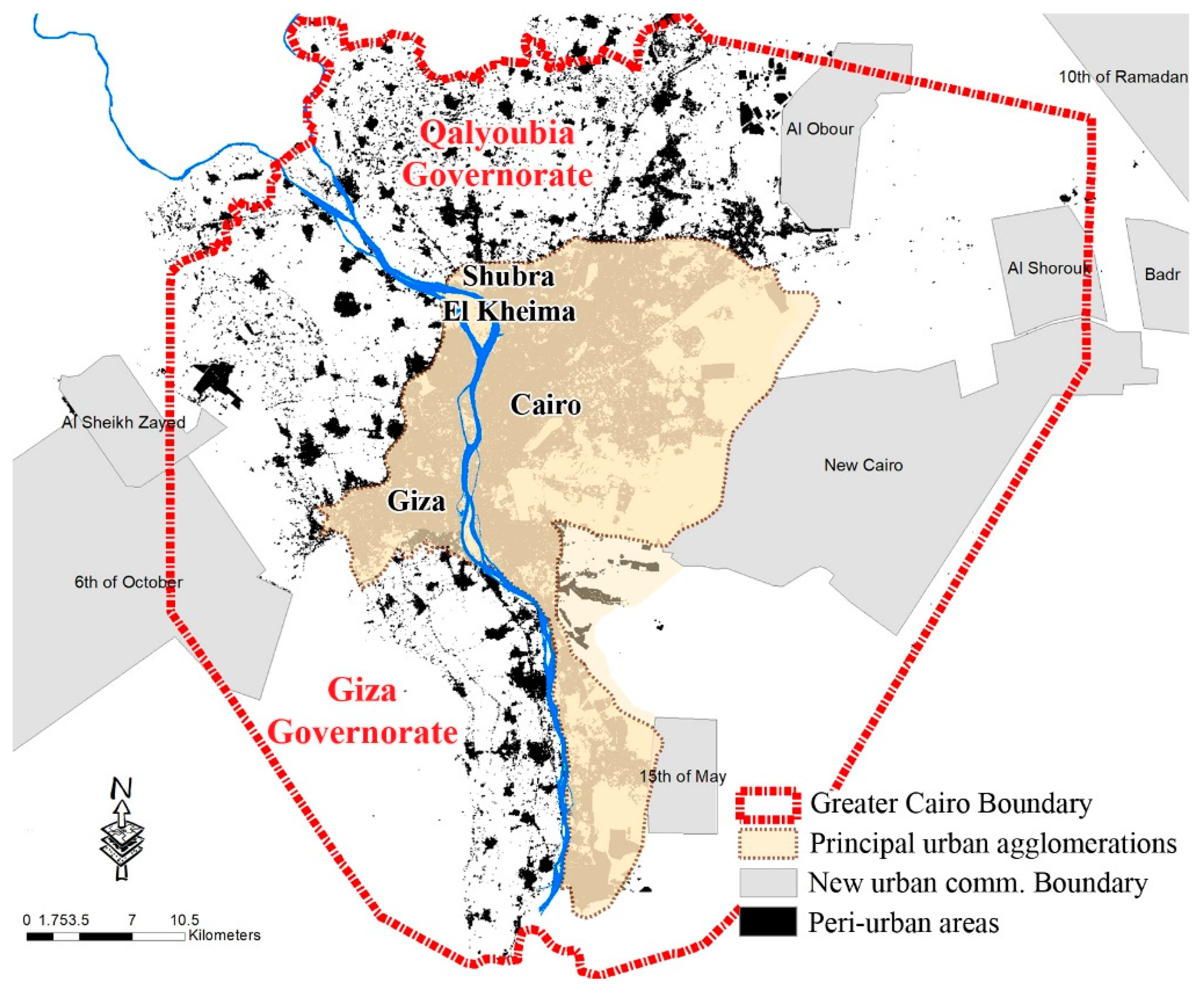
2.1. Study Area

This study focuses on the peri-urban areas (PUAs) within the Greater Cairo (GC) boundary in Egypt (30°02′40″ N 31°14′08″ E). These areas encircle the principal urban agglomerations of Cairo, Giza, and Shubra El Kheima. PUAs are dynamic zones situated on the outskirts of these bustling urban centers, characterized by a distinct lack of full integration into the intricate urban fabric. Despite their significance, PUAs in the GC context are often overlooked components of Egypt’s urban landscape [43].
The initial delineation of the PUAs of GC, spearheaded by the World Bank in collaboration with David Sims in 2008 [44,45], identified two governorates, namely, Qalyoubia and Giza, as integral components of this spatial entity [45]. Figure 1 illustrates the spatial distribution of the PUAs within the GC boundary.
The PUAs encompass approximately 35% of the entire area of the GC region, spanning 104.8 thousand hectares, and they accommodate approximately 5.15 million residents, as depicted in Table 1. This substantial population residing in the PUAs underscores their significance in terms of both demographic density and urban expansion. Moreover, the PUAs play a multifaceted role in the socio-economic dynamics of GC, contributing to the region’s agricultural production, employment opportunities, and environmental sustainability.

2.2. Data Sources

Comprehensive spatial data from multiple sources were utilized in this study to analyze the PUAs of GC. The analysis employed Landsat satellite imagery spanning the following three distinct periods: 2001, 2011, and 2021. Landsat satellites capture multispectral imagery, enabling the identification and classification of various land cover types [22]. Each Landsat satellite carries sensors that capture data across multiple spectral bands, allowing for the discrimination of land cover features such as vegetation, water bodies, and built-up areas [47]. These images, acquired on the 10 April 2001 (Landsat 7), 12 October 2011 (Landsat 5), and 31 May 2021 (Landsat 8), respectively, offer valuable insights into the temporal dynamics of land-use and land-cover changes within the study area.
Additionally, to delineate administrative boundaries crucial for the spatial analysis, three shapefiles were obtained from the Ministry of Housing in Egypt. These shapefiles represent the administrative boundaries of GC, principal urban agglomerations, and new urban communities. Acquired in 2016, the administrative boundaries data provide a foundational framework for understanding the spatial context and governance structures within the study area. Table 2 illustrates the comprehensive data collection process undertaken for this study.

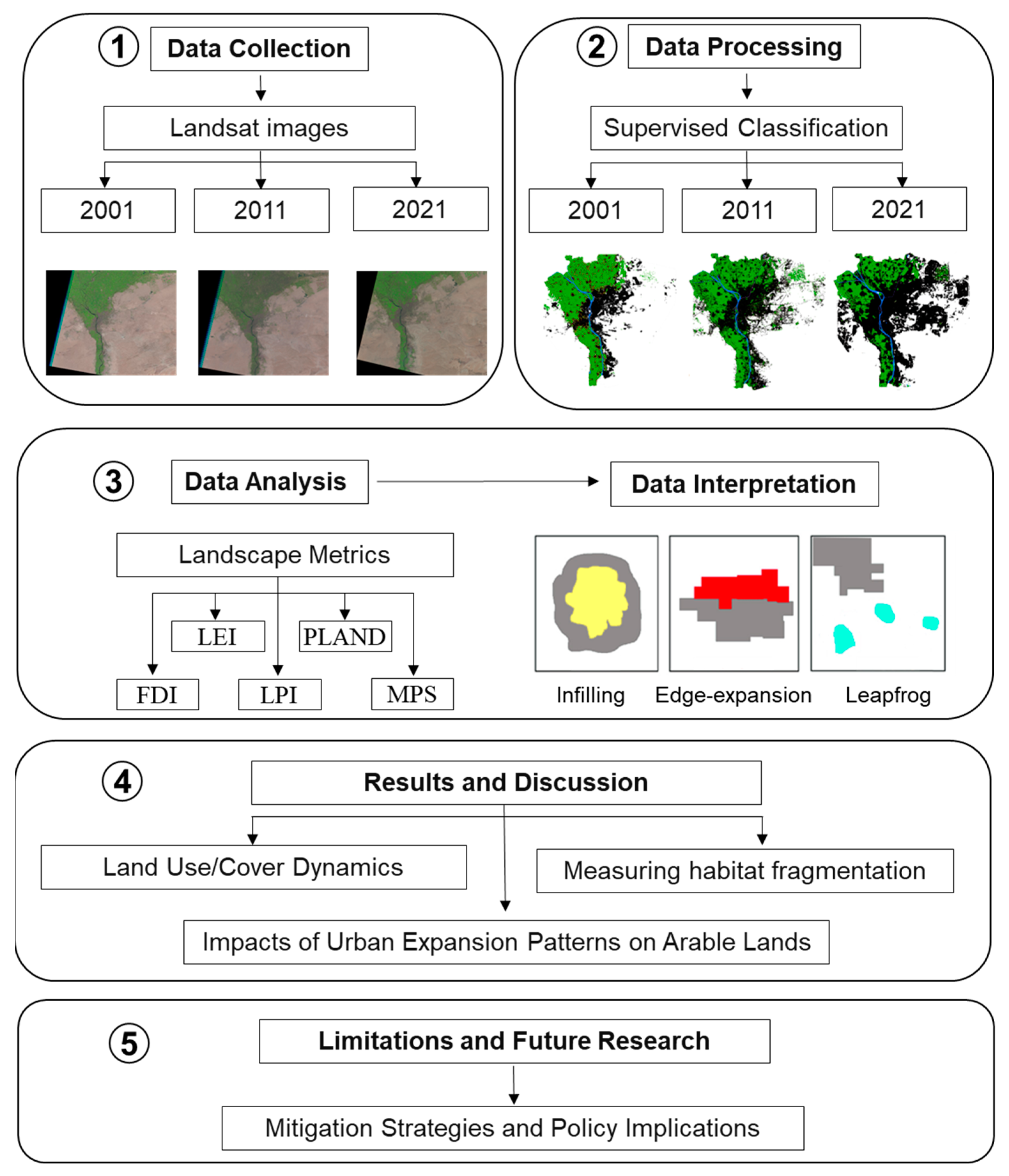
2.3. Data Processing and Analysis

The Random Forest (RF) algorithm was employed to classify the three satellite images from 2001, 2011, and 2021 to analyze the changes in land use/cover (LUC) in GC. To achieve this, 100 sample signatures were collected individually for each LUC using ArcGIS Pro 3.1.0 (Esri, Redlands, CA, USA). The resulting LUC map identified the following four distinct categories in the study area: urban land, agricultural land, water, and bare land. The RF image classification process was conducted using R software version 4.3.2 (The R Foundation, accessed on 30 November 2023). Subsequently, a post-classification comparison was undertaken using the LUC matrix to discern alterations in the LUC. To gauge the accuracy of each classified image, a confusion matrix based on Google Earth images was employed. The accuracy of the LUC map has been examined using kappa statistics, and this showed that the accuracy was 0.92, 0.92, and 0.93 for the years 2001, 2011, and 2021, respectively.
Focusing on the impacts resulting from uncontrolled urban expansion in the PUAs of GC, the study investigated the built-up urban class in the PUAs separately. Consequently, nonurban classes (agricultural land, water, and desert) were combined into one category labeled nonurban. Subsequently, the class of built-up urban areas was coded as black and the nonurban class was coded as white for examining urban expansion in the PUAs.

2.4. Landscape Metrics

Landscape metrics offer a quantitative assessment of landscape pattern and structure, enabling the analysis and comparison of landscapes across various scales [37]. These metrics play a crucial role in understanding how human activities, such as urban expansion, influence natural landscapes and the potential ecological consequences associated with fragmentation [34,49]. Fragstats software version 4.2 (Fragstats, LLC, accessed on 11 December 2023) was utilized for calculating the landscape metrics in the PUAs of GC in 2001, 2011, and 2021. Five specific metrics were utilized to assess the environmental impact of urban expansion in the study area. The details of these metrics are outlined below.

2.4.1. Landscape Expansion Index (LEI)

The LEI is a quantitative measure that computes changes in landscape configuration over time. It helps quantify the extent of urban expansion by measuring alterations in the arrangement of a landscape over a period of time [50]. This is particularly useful in PUAs where urbanization is often rapid and can have significant environmental consequences. This index aids in categorizing urban expansion patterns, distinguishing between infill development, edge expansion, and leapfrogging, and further contributing to a nuanced understanding of the landscape transformation [51,52].

2.4.2. Percentage of Landscape (PLAND)

The Percentage of Landscape denotes the proportion of a given patch type’s landscape area that it occupies [53]. In PUAs, changes in PLAND values offer valuable information about the evolving distribution and prevalence of urban land expansion. Variations in PLAND values signal shifts in landscape patterns, providing important information for understanding the effects of urban growth on the overall landscape composition and, by extension, its potential environmental consequences [54].

2.4.3. Fractal Dimension Index (FDI)

The FDI provides information on the shape of the landscape, which is essential for assessing habitat loss, biodiversity impacts, and the overall ecological connectivity of the peri-urban landscape [55].

2.4.4. Mean Patch Size (MPS)

The Mean Patch Size is employed to quantify the mean volume of patches within the landscape [34]. In the context of PUAs, variations in MPS reflect changes in land parcelization, fragmentation, or consolidation. Understanding the average size of a group of patches is crucial for gauging the level of landscape fragmentation or connectivity and offering insights into the potential ecological consequences of urban expansion [56].

2.4.5. Largest Patch Index (LPI)

The Largest Patch Index signifies the proportion of the entire terrain that is occupied by the biggest patch [56]. It serves to measure the dominance of the biggest continuous patch within the landscape. In peri-urban contexts, variations in LPI provide indications of the concentration or distribution of urban patches. A higher LPI indicates a landscape where a single, sizable patch dominates a sizable portion of it, potentially having an impact on ecological connectivity and habitat distribution [34].
Detailed descriptions of the used landscape metrics are presented in Table 3. Figure 2 presents the sequence of steps followed in the investigation.

3. Results and Discussion

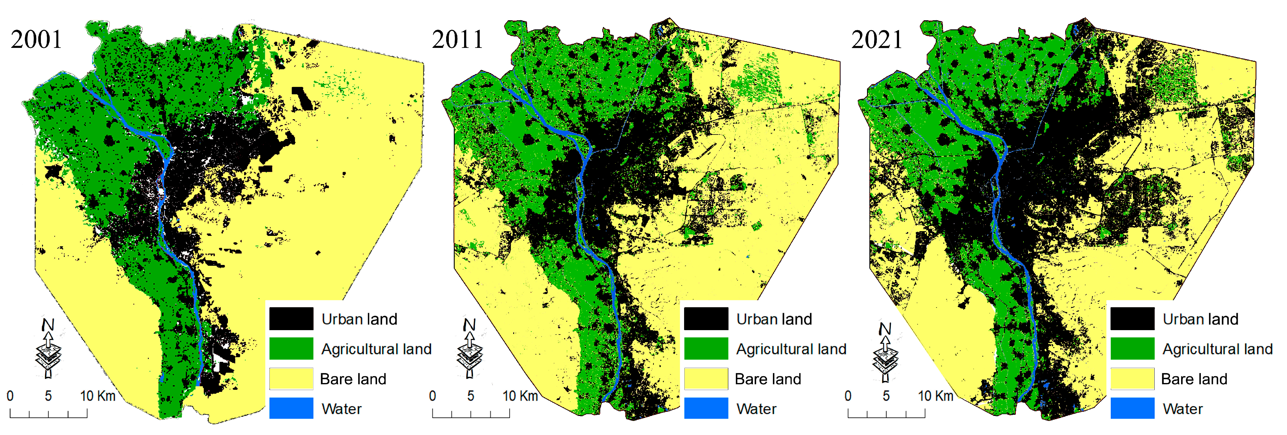
3.1. Land Use/Cover Dynamics

Throughout the period spanning from 2001 to 2021, GC has undergone substantial transformations in its land use/cover (LUC), with the most significant alterations observed within the urban class (as illustrated in Figure 3). Notably, urban areas have experienced rapid expansion, primarily at the expense of agricultural land within the PUAs. The detection of LUC alterations during this timeframe revealed the following remarkable shift in land-use patterns: the urbanized area expanded from 48.8 thousand hectares to 124.5 thousand hectares, while bare land decreased from 146.8 thousand hectares to 122.9 thousand hectares. Conversely, agricultural land witnessed a considerable reduction, decreasing from 101.7 thousand hectares to 49.9 thousand hectares. Concurrently, there was a marginal decrease in the extent of water bodies, which contracted from 4.4 thousand hectares to 4.3 thousand hectares over the same period due to urban expansion. Table 4 provides a detailed overview of the LUC changes observed from 2001 to 2021.
Between 2001 and 2011, the amount of urban land increased by 23.6 thousand hectares, primarily at the expense of agricultural land, which decreased by 22.7 thousand hectares during the same period. The reduction in agricultural land was accompanied by a slight decrease in bare land of 1.1 thousand hectares, while no significant changes were observed in the areas covered by water during this period. In the subsequent decade, from 2011 to 2021, urban expansion continued, with an increase of 52.1 thousand hectares. This expansion was driven by both the conversion of agricultural land in PUAs and the development of new urban areas on bare land. Consequently, the amounts of agricultural land and bare land decreased by 29 thousand hectares and 22.8 thousand hectares, respectively, during this period. Additionally, there was a slight decrease of 100 hectares in the areas covered by water.
These findings indicate that urban expansion has emerged as the main driver of LUC changes, a trend observed in similar burgeoning metropolitan areas in the Global South [57,58,59]. For instance, Agegnehu et al. [60] found that urban expansion was the primary driver of LUC changes in the PUAs of the Amhara National Regional State of Ethiopia, while similar results were reported by Dutta and Das [61] and Salem et al. [62] for the English Bazar Urban Agglomeration, West Bengal, and Delhi, India, respectively.

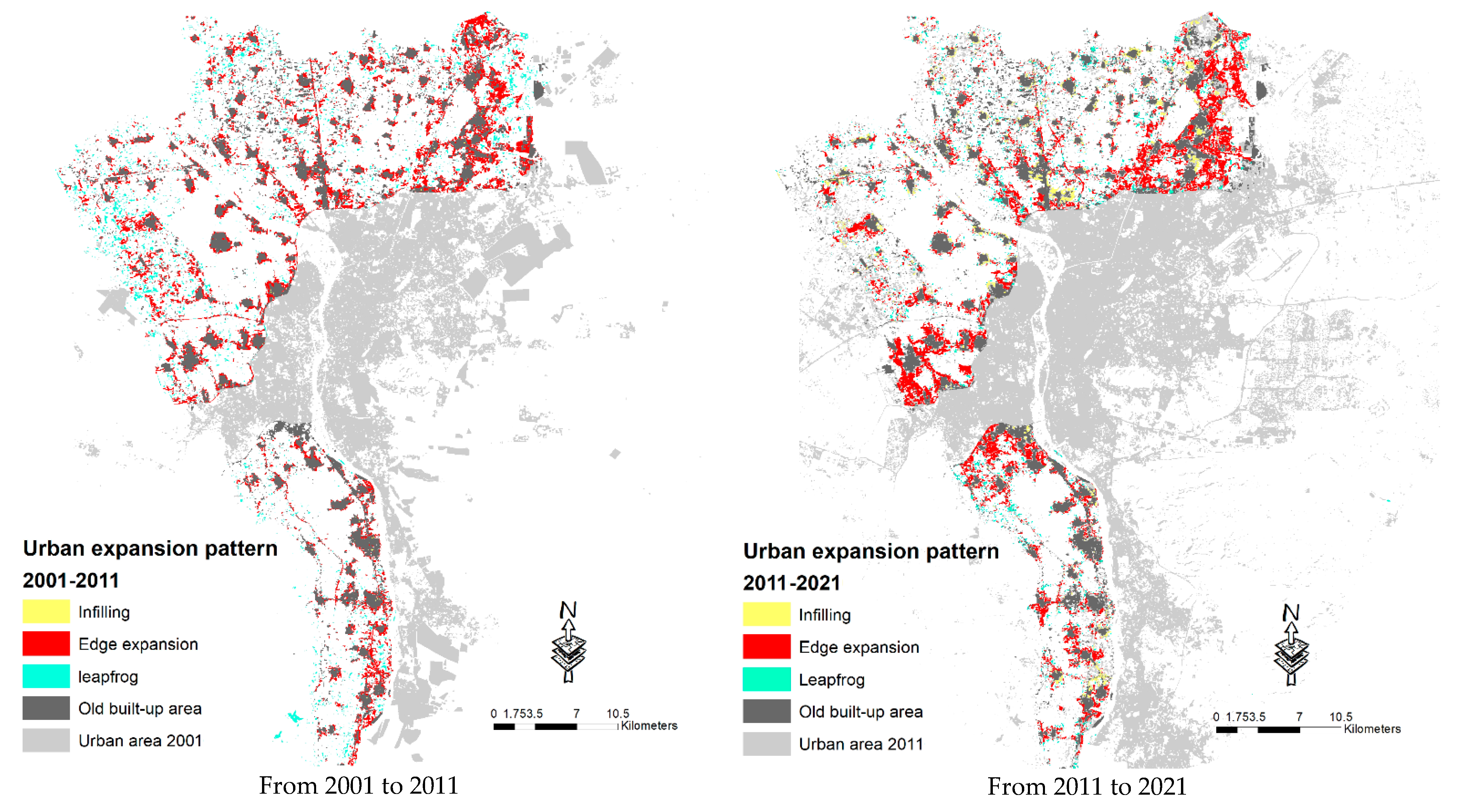
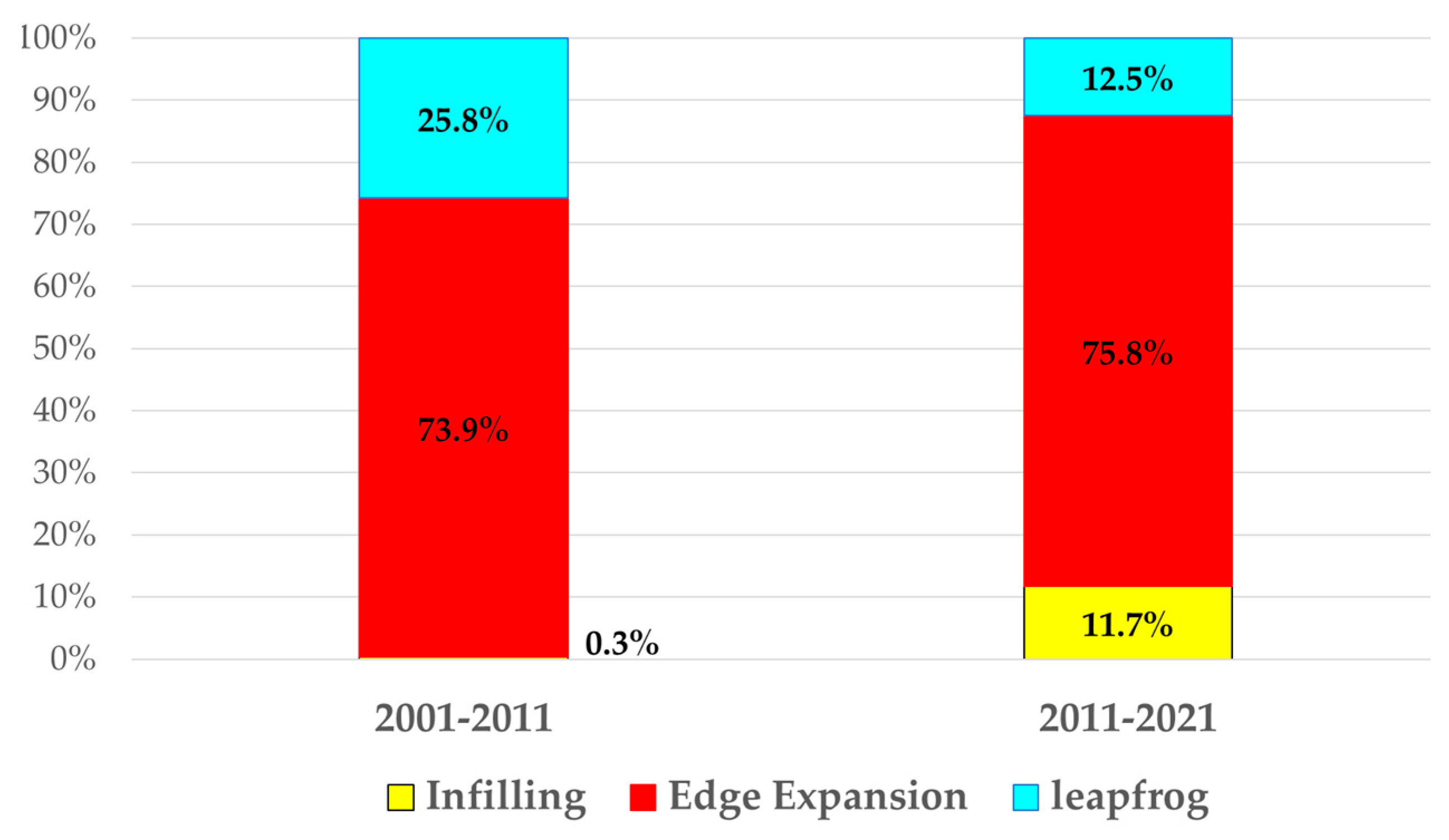
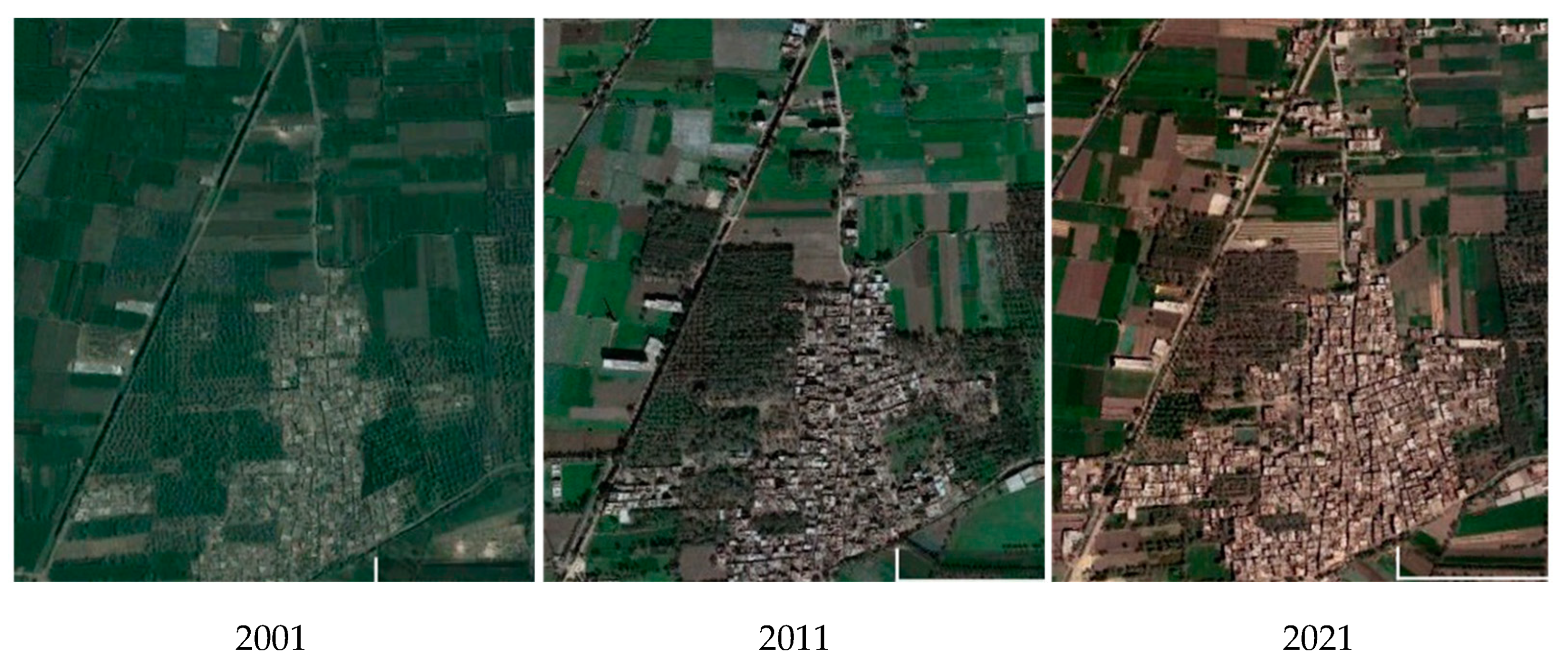
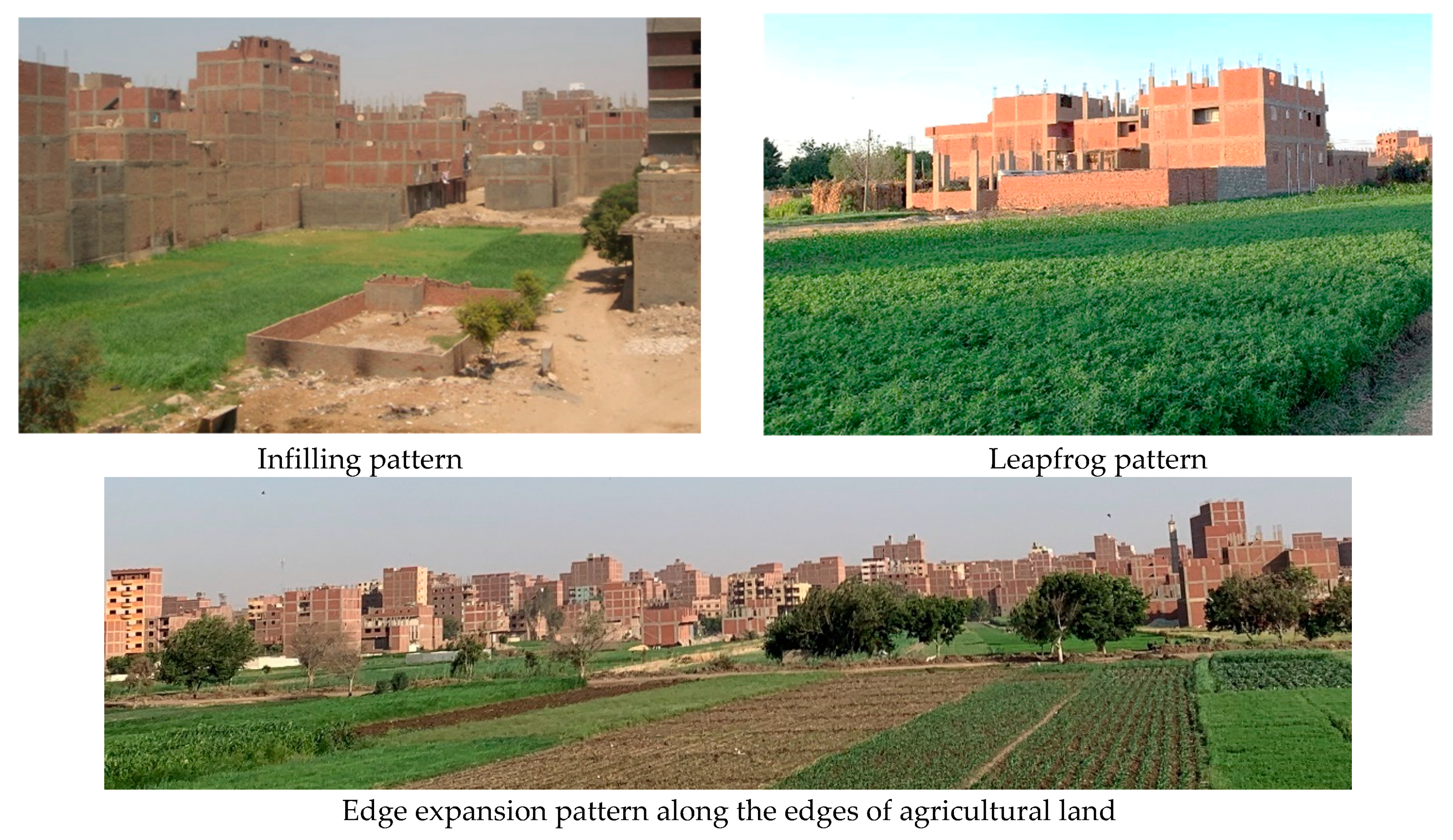
3.2. Urban Expansion Patterns

The Land Expansion Index (LEI) identified three primary urban expansion patterns within the PUAs of GC from 2001 to 2021. Edge expansion was the predominant urban development pattern within the PUAs of GC from 2001 to 2021. Leapfrog expansion emerged as the second dominant pattern, mainly concentrated on the edges of the study area during the period 2001 to 2011 and aligning with roads during the subsequent decade (from 2011 to 2021). The infilling pattern was limited during the initial stage from 2001 to 2011 but significantly increased during the later period from 2011 to 2021, predominantly manifesting within agricultural pockets that had emerged during the prior decade (from 2001 to 2011). Figure 4 illustrates the urban expansion patterns in the study area from 2001 to 2021.
Edge expansion notably accounted for a majority of the increases in urbanized areas, comprising 73.9% during the initial decade (2001–2011) and a substantial 75.8% during the subsequent decade (2011–2021). The leapfrog pattern decreased from 25.8% during the initial decade (2001–2011) to 12.5% during the subsequent decade (2011–2021). Between 2011 and 2021, there was a notable surge in the prevalence of the infilling pattern, exhibiting an increase of over 10% after 2011. Figure 5 depicts the distribution of landscape expansion patterns from 2001 to 2021.
Edge expansion signifies the gradual encroachment of urbanization onto the outskirts of existing settlements. As urban expansion extends into previously undeveloped areas, fertile lands face increasing pressures, exacerbating land fragmentation and degradation. This poses significant challenges to agricultural sustainability and food security in the region, as noted by Salem et al. [22]. Figure 6 illustrates this edge expansion pattern in an existing village within the peri-urban areas of Greater Cairo.
It is worth mentioning that edge expansion and leapfrog patterns were the dominant patterns observed in many cities in the Global South, as noted by Follmann et al. [3]. These patterns reflect common trends in urban development across rapidly growing urban regions, where urbanization often extends outward from existing urban cores, leading to the gradual expansion of built-up areas along the peripheries and transportation corridors [8]. Understanding these prevalent expansion patterns is essential for formulating effective urban planning and management strategies to address the challenges associated with rapid urban growth, land-use change, and environmental degradation in PUAs.

3.3. Arable Land Losses

The analysis revealed a substantial loss of agricultural land, exceeding 2500 hectares per year during the study period. This finding aligned with similar results reported by Youssef et al. [21] and Salem et al. [22] in their studies on urban sprawl in GC for the periods 2007–2017 and 2011–2018, respectively.
The current patterns of urban expansion manifest as dispersed, smaller pockets encroaching upon arable land, resulting in its fragmentation and rendering the remaining cultivated areas susceptible to future urban encroachment [21]. According to the perspectives presented by Abd El-kawy et al. [47], this form of urban expansion is notably inefficient in its utilization of cultivated land due to low urban expansion densities in these regions, consequently contributing to an escalation in arable land consumption. Figure 7 illustrates the different spatial types of landscape expansion in the PUAs of GC and their impacts on agricultural land.
Urban expansion observed in the PUAs of GC is primarily characterized as polycentric, signifying the outward expansion of existing towns and villages into neighboring agricultural zones. This mode of urbanization aligns with the traits of informal development commonly observed in developing countries [26,59]. Similar observations were made by Sumbo et al. [63] for the PUAs in Kumasi, Ghana; by Atta-ur-Rahman et al. [64] for the PUAs in Peshawar, Pakistan; and by Song et al. [65] for the PUAs in Beijing, China, revealing comparable outcomes.

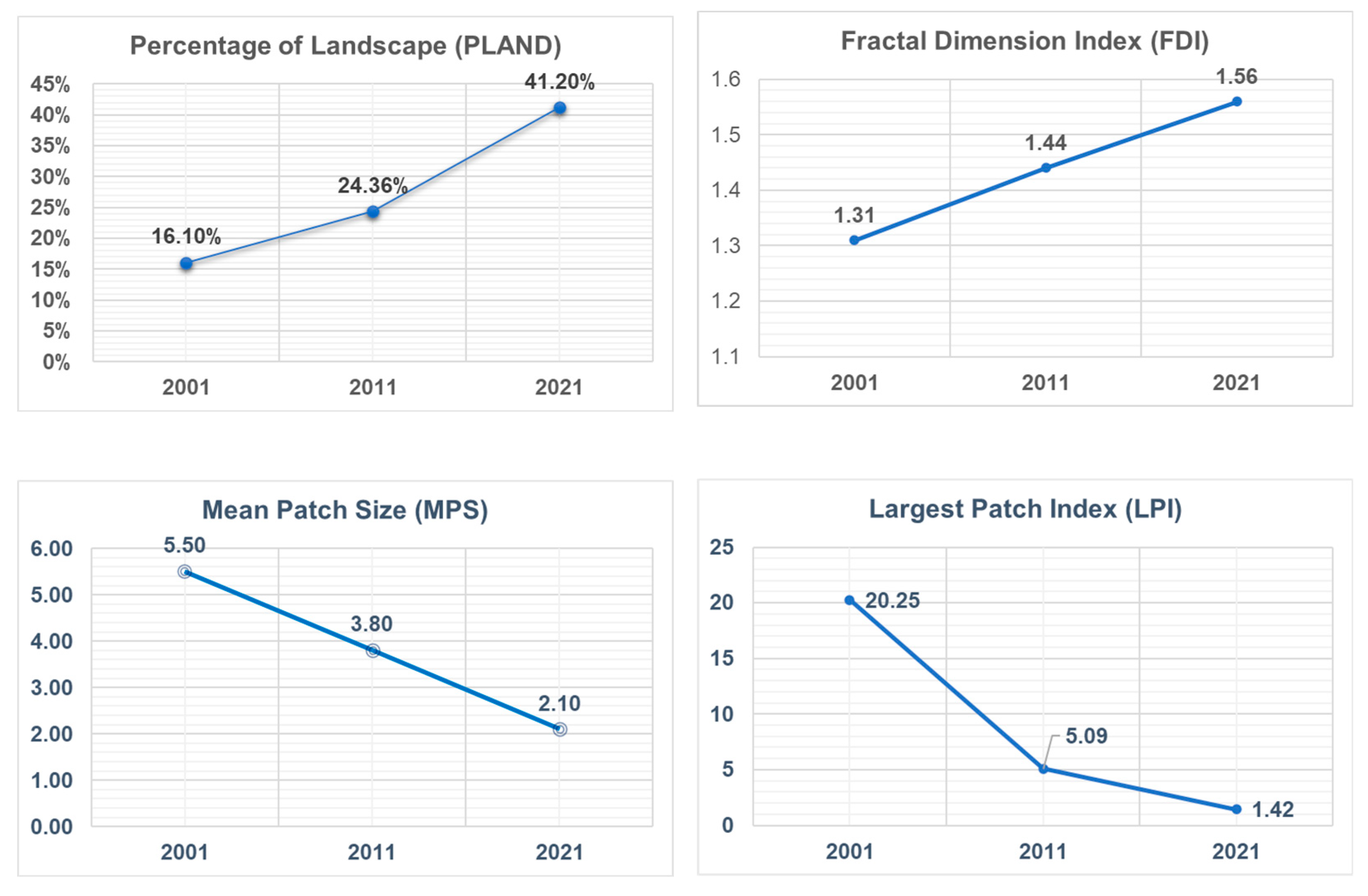
3.4. Landscape Fragmentation

The analysis of landscape metrics demonstrated significant alterations in the PUAs’ spatial configurations, particularly in terms of fragmentation. As depicted in Figure 8, the PLAND indicated a remarkable expansion in urban land, rising from 16.10% in 2001 to 24.36% in 2011 and further increasing to 41.20% in 2021. Concurrently, the FDI exhibited an increasing trend, suggesting heightened complexity and fragmentation in the urban landscape, with values climbing from 1.31 in 2001 to 1.56 in 2021. The MPS values demonstrate notable decreases, indicating a trend toward smaller urban patches, with average sizes shrinking from 5.5 in 2001 to 2.1 in 2021. Moreover, the LPI witnessed a decline, reflecting the reduced dominance of the largest urban patch over time, dropping from 20.25 in 2001 to 1.42 in 2021. Collectively, these metrics suggest a dynamic transformation in the urban spatial structure, indicated by significant fragmentation, increased complexity, and a more distributed pattern of urban land across the landscape. Figure 8 shows the changes in the landscape metrics throughout the study period.
The steady rise in the FDI value from 1.31 to 1.44 and, subsequently, from 1.44 to 1.56 signified a progressive increase in landscape fragmentation over time. The decreases in MPS values implied more dispersion in the landscape and increases in disconnected patches. Moreover, the decline in the LPI value indicated landscape fragmentation, as noted by Das et al. [56]. This suggests that the degree of landscape fragmentation has increased over time due to rapid urban expansion. These results were in line with those of Magidi et al. [66], which demonstrated a positive relationship between the level of landscape fragmentation and the degree of urban sprawl in the City of Tshwane, South Africa. Similarly, Fenta et al. [67] and Abedini et al. [33] obtained comparable findings in their respective studies conducted in Mekelle City, Ethiopia, and Urmia City, Iran. These studies collectively underscore the phenomenon of landscape fragmentation driven by rapid urban expansion in the Global South.

3.5. Mitigation Strategies and Policy Implications

While several laws and legislation exist in Egypt to regulate urban expansion and protect agricultural land, such as Unified Building Law no. 119/2008, Urban Planning Law no. 3/1982, and Agriculture Land Protection Law no. 116/1983, their effectiveness in managing the challenges of rapid urban expansion has proven insufficient [47]. This inadequacy stems from the authorities’ inability to enforce these laws adequately, particularly during the last two decades [22]. Efforts to mitigate the adverse effects of urban sprawl on agricultural lands necessitate the implementation of comprehensive land management strategies, including the establishment of green belts, preservation of agricultural reserves, and promotion of compact urban forms to minimize land consumption in PUAs.
Implementing effective wastewater treatment systems and stormwater management practices is essential for mitigating water pollution resulting from urban activities in PUAs [68]. Additionally, advocating for sustainable agricultural practices and actively supporting local biodiversity conservation efforts are integral components of promoting a balanced link between urbanization and an ecosystem [69]. Together, these measures aid in mitigating the environmental effects of urban expansion on PUAs.
Embedding environmental considerations within urban planning frameworks is crucial, with a specific focus on preserving peri-urban green spaces and sustainable natural resource management while mitigating the effects of urbanization on ecosystems [24,26]. Policy interventions should prioritize the establishment of effective waste management systems, green infrastructure projects, and regulations guiding responsible land use [70]. Moreover, community engagement initiatives and a commitment to social equity must be integral components of policy formulation to ensure sustainable development [18].
Scholars have emphasized the pivotal role of effective governance structures and well-defined policies in steering urban expansion toward sustainable trajectories [71]. Clear land-use policies, zoning regulations, and strategic planning frameworks have been identified as essential tools for guiding peri-urban development and managing competing demands on limited land resources [63].
Past research has identified potential areas for improvement in governance and policy frameworks for PUAs [72], including strategies such as strengthening institutional capacity, enhancing inter-agency coordination, and involving local communities in decision-making processes [71]. Advocacy for adaptive and flexible policy frameworks that respond to the dynamic nature of peri-urban development is crucial.
Furthermore, academic contributions underscore the necessity of adopting a comprehensive and integrated strategy that incorporates environmental, social, and economic factors within governance frameworks and policy structures [2]. Given the swift transformations occurring in PUAs, continuous research in this domain remains essential to inform policies that foster sustainable development in the Global South [3].

3.6. Limitations and Future Research

Peri-urban areas are inherently dynamic, characterized by boundaries that undergo frequent changes over time. Accurately delineating these boundaries necessitates a significant amount of updated data, which can be challenging to obtain, particularly in regions such as GC and other cities in the Global South. In this study, the boundaries of PUAs in GC were relied upon as they were defined by a World Bank study in 2008, with subsequent updates based on studies conducted by Salem et al. in 2015 and 2020 [40,73]. However, it is essential for future studies conducted on the PUAs of GC to consider updating the boundaries to reflect any changes that may have occurred since then. This will ensure that analyses and conclusions accurately represent the current state of PUAs and facilitate effective planning and policymaking.
The analysis in this study primarily relied on data extracted from Landsat satellite images, which were chosen due to the scarcity of numerical data for the study area—a common challenge faced in many regions of the Global South. While this research contributes significant insights into the environmental consequences of urban expansion within PUAs, there are notable gaps in the literature. Insufficient attention has been paid to the intricate socio-cultural aspects present within peri-urban communities and their interactions with their environments. Additionally, there is a need for more in-depth research on the specific impacts of urban expansion on vulnerable populations, including marginalized communities living in informal settlements.
The literature also lacks a comprehensive understanding of the long-term consequences of peri-urban development on regional ecosystems and the broader implications for climate change resilience. Future research should explore these areas, including a deeper investigation into the socio-cultural dimensions of PUAs and how local communities perceive and adapt to urban expansion. Research is also needed to assess how modern technologies and data sources, such as machine learning and high-resolution satellite imagery, can enhance our understanding of peri-urban dynamics. Furthermore, research specifically examining the efficacy of community-based initiatives and participatory techniques in reducing the adverse effects of urban expansion could provide significant knowledge for promoting sustainable development.

4. Conclusions

Our study sheds light on the impact of urban expansion on the landscape in the PUAs of GC for the period 2001–2021. Urban expansion has emerged as a significant driver of land-use changes, particularly affecting arable lands. The loss of over 51 thousand hectares of cultivated land, primarily due to edge expansion, has raised concerns about the sustainability of urban growth and food security. The landscape metrics revealed an escalation in fragmentation, characterized by a more distributed pattern of urban land across the landscape. The reduction in the mean patch size suggested the emergence of smaller urban patches, while the decline in the largest patch index indicated reduced dominance, reflecting a dynamic spatial transformation. Mitigation strategies and policy implications have underscored the importance of sustainable land-use planning, green space preservation, and effective governance to address the challenges posed by urbanization. Future research should explore socio-cultural dynamics, impacts on vulnerable populations, and the long-term consequences of peri-urban development to achieve a comprehensive understanding of the complexities and opportunities associated with urbanization in the Global South. Integrating environmental, social, and economic considerations into policy frameworks is essential for steering peri-urban development toward sustainable trajectories amidst the evolving landscapes of the 21st century.

Author Contributions

M.S. wrote the manuscript, conducted the analysis, and edited the manuscript, and N.T. revised the manuscript. All authors have read and agreed to the published version of the manuscript.

Funding

This research was supported by the Japan Society for the Promotion of Science (JSPS KAKENHI grant no. 22F21047).

Institutional Review Board Statement

Not applicable.

Informed Consent Statement

Not applicable.

Data Availability Statement

Data will be provided upon request to the corresponding author.

Conflicts of Interest

The authors declare no conflicts of interest.

References

  1. Hutchings, P.; Willcock, S.; Lynch, K.; Bundhoo, D.; Brewer, T.; Cooper, S.; Keech, D.; Mekala, S.; Mishra, P.P.; Parker, A.; et al. Understanding Rural–Urban Transitions in the Global South through Peri-Urban Turbulence. Nat. Sustain. 2022, 5, 924–930. [Google Scholar] [CrossRef]
  2. Follmann, A.; Willkomm, M.; Dannenberg, P. As the City Grows, What Do Farmers Do? A Systematic Review of Urban and Peri-Urban Agriculture under Rapid Urban Growth across the Global South. Landsc. Urban Plan. 2021, 215, 104186. [Google Scholar] [CrossRef]
  3. Follmann, A.; Kennedy, L.; Pfeffer, K.; Wu, F. Peri-Urban Transformation in the Global South: A Comparative Socio-Spatial Analytics Approach. Reg. Stud. 2023, 57, 447–461. [Google Scholar] [CrossRef]
  4. Mpofu, G.; Darkoh, M.K.; Gwebu, T. Peri-Urbanization Landuse Dynamics: An Analysis of Evolving Patterns and Their Impacts on Gabane Village, Botswana. GeoJournal 2018, 83, 725–741. [Google Scholar] [CrossRef]
  5. Makita, K.; Fèvre, E.M.; Waiswa, C.; Bronsvoort, M.D.C.; Eisler, M.C.; Welburn, S.C. Population-Dynamics Focussed Rapid Rural Mapping and Characterisation of the Peri-Urban Interface of Kampala, Uganda. Land Use Policy 2010, 27, 888–897. [Google Scholar] [CrossRef]
  6. Kombe, W.J. Land Use Dynamics in Peri-Urban Areas and Their Implications on the Urban Growth and Form: The Case of Dar Es Salaam, Tanzania. Habitat Int. 2005, 29, 113–135. [Google Scholar] [CrossRef]
  7. McGee, T.G. Emergence of Desakota Regions in Asia: Expanding a Hypothesis. In The Extended Metropolis: Settlement Transition Is Asia; Ginsburg, N.S., Koppel, B., McGee, T.G., Eds.; University of Hawaii Press: Honolulu, HI, USA, 1991; ISBN 9780824812973. [Google Scholar]
  8. Follmann, A. Geographies of Peri-Urbanization in the Global South. Geogr. Compass 2022, 16, e12650. [Google Scholar] [CrossRef]
  9. Ravetz, J.; Fertner, C.; Nielsen, T.S. The Dynamics of Peri-Urbanization. In Peri-Urban Futures: Scenarios and Models for Land Use Change in Europe; Springer-Verlag: Berlin/Heidelberg, Germany, 2013; pp. 13–44. ISBN 9783642305290. [Google Scholar]
  10. Salem, M.; Tsurusaki, N.; Divigalpitiya, P. Land Use/Land Cover Change Detection and Urban Sprawl in the Peri-Urban Area of Greater Cairo since the Egyptian Revolution of 2011. J. Land Use Sci. 2020, 15, 592–606. [Google Scholar] [CrossRef]
  11. Sahani, S.; Raghavaswamy, V. Analyzing Urban Landscape with City Biodiversity Index for Sustainable Urban Growth. Envrion. Monit. Assess. 2018, 190, 471. [Google Scholar] [CrossRef]
  12. Shoyama, K.; Yamagata, Y. Predicting Land-Use Change for Biodiversity Conservation and Climate-Change Mitigation and Its Effect on Ecosystem Services in a Watershed in Japan. Ecosyst. Serv. 2014, 8, 25–34. [Google Scholar] [CrossRef]
  13. Sahana, M.; Ravetz, J.; Patel, P.P.; Dadashpoor, H.; Follmann, A. Where Is the Peri-Urban? A Systematic Review of Peri-Urban Research and Approaches for Its Identification and Demarcation Worldwide. Remote Sens. 2023, 15, 1316. [Google Scholar] [CrossRef]
  14. Salem, M.; Tsurusaki, N.; Divigalpitiya, P.; Osman, T.; Hamdy, O.; Kenawy, E. Assessing Progress Towards Sustainable Development in the Urban Periphery: A Case of Greater Cairo, Egypt. Int. J. Sustain. Dev. Plan. 2020, 15, 971–982. [Google Scholar] [CrossRef]
  15. Webster, D.; Muller, L. Peri-Urbanization: Zones of Rural-Urban Transition. In Human Settlement Development; Sassen, S., Ed.; Eolss Publisher Co., Ltd.: Oxford, UK, 2009; Volume 1, pp. 281–290. Available online: https://www.semanticscholar.org/paper/PERI-URBANIZATION-:-ZONES-OF-RURAL-URBAN-TRANSITION-Webster-Muller/95c0f07d24a55613799fbafb6f7dceb876d14e5e (accessed on 12 February 2024).
  16. Kontgis, C.; Schneider, A.; Fox, J.; Saksena, S.; Spencer, J.H.; Castrence, M. Monitoring Peri-Urbanization in the Greater Ho Chi Minh City Metropolitan Area. Appl. Geogr. 2014, 53, 377–388. [Google Scholar] [CrossRef]
  17. Kim, M. Peri-Urbanization and Its Impacts on Rural Livelihoods in Mumbai ’ s Urban Fringe. In Proceedings of the Peri-urbanization and Its Impacts on Rural Livelihoods in Mumbai’s Urban Fringe 48th ISOCARP Congress, Mumbai, India, 10–13 September 2012; pp. 1–10. [Google Scholar]
  18. Aguilar, A.G.; Flores, M.A.; Lara, L.F. Peri-Urbanization and Land Use Fragmentation in Mexico City. Informality, Environmental Deterioration, and Ineffective Urban Policy. Front. Sustain. Cities 2022, 4, 790474. [Google Scholar] [CrossRef]
  19. Chettry, V. Peri-Urban Area Delineation and Urban Sprawl Quantification in Thiruvananthapuram Urban Agglomeration, India, from 2001 to 2021 Using Geoinformatics. Appl. Geomat. 2022, 14, 639–652. [Google Scholar] [CrossRef]
  20. La Rosa, D.; Geneletti, D.; Spyra, M.; Albert, C.; Fürst, C. Sustainable Planning for Peri-Urban Landscapes; Springer International Publishing: Cham, Switzerland, 2018; ISBN 9783319745152. [Google Scholar]
  21. Youssef, A.; Sewilam, H.; Khadr, Z. Impact of Urban Sprawl on Agriculture Lands in Greater Cairo. J. Urban Plan. Dev. 2020, 146, 05020027. [Google Scholar] [CrossRef]
  22. Salem, M.; Tsurusaki, N.; Divigalpitiya, P. Remote Sensing-Based Detection of Agricultural Land Losses around Greater Cairo since the Egyptian Revolution of 2011. Land Use Policy 2020, 97, 104744. [Google Scholar] [CrossRef]
  23. Wang, X.; Blanchet, F.G.; Koper, N. Measuring Habitat Fragmentation: An Evaluation of Landscape Pattern Metrics. Methods Ecol. Evol. 2014, 5, 634–646. [Google Scholar] [CrossRef]
  24. Haddad, N.M.; Brudvig, L.A.; Clobert, J.; Davies, K.F.; Gonzalez, A.; Holt, R.D.; Lovejoy, T.E.; Sexton, J.O.; Austin, M.P.; Collins, C.D.; et al. Habitat Fragmentation and Its Lasting Impact on Earth’s Ecosystems. Sci. Adv. 2015, 1, e1500052. [Google Scholar] [CrossRef]
  25. Peng, Y.; Mi, K.; Wang, H.; Liu, Z.; Lin, Y.; Sang, W.; Cui, Q. Most Suitable Landscape Patterns to Preserve Indigenous Plant Diversity Affected by Increasing Urbanization: A Case Study of Shunyi District of Beijing, China. Urban For. Urban Green. 2019, 38, 33–41. [Google Scholar] [CrossRef]
  26. Zambrano, L.; Aronson, M.F.J.; Fernandez, T. The Consequences of Landscape Fragmentation on Socio-Ecological Patterns in a Rapidly Developing Urban Area: A Case Study of the National Autonomous University of Mexico. Front. Envrion. Sci. 2019, 7, 152. [Google Scholar] [CrossRef]
  27. Mboup, G.; Oyelaran-Oyeyinka, B.; Agyemang-Bonsu, W.K.; Lata, K.; Silva, V.; Bakarr, M.I.; Sow, I.; Mudau, N.; Mhangara, P.; Mbow-Diokhane, A.; et al. Africa’s Smart City Foundation: Urbanization, Urban Form and Structure, Land Tenure and Basic Infrastructures. In Smart Economy in Smart African Cities: Sustainable, Inclusive, Resilient and Prosperous; Springer: Berlin/Heidelberg, Germany, 2019; p. 492. ISBN 9811334714. [Google Scholar]
  28. Aguilar, A.G. Peri-Urbanization, Illegal Settlements and Environmental Impact in Mexico City. Cities 2008, 25, 133–145. [Google Scholar] [CrossRef]
  29. Dissanayake, D.; Morimoto, T.; Ranagalage, M.; Murayama, Y. Land-Use/Land-Cover Changes and Their Impact on Surface Urban Heat Islands: Case Study of Kandy City, Sri Lanka. Climate 2019, 7, 99. [Google Scholar] [CrossRef]
  30. Aithal, B.H.; Ramachandra, T.V. Visualization of Urban Growth Pattern in Chennai Using Geoinformatics and Spatial Metrics. J. Indian Soc. Remote Sens. 2016, 44, 617–633. [Google Scholar] [CrossRef]
  31. Chettry, V.; Surawar, M. Urban Sprawl Assessment in Eight Mid-Sized Indian Cities Using RS and GIS. J. Indian Soc. Remote Sens. 2021, 49, 2721–2740. [Google Scholar] [CrossRef]
  32. Cao, H.; Liu, J.; Chen, J.; Gao, J.; Wang, G.; Zhang, W. Spatiotemporal Patterns of Urban Land Use Change in Typical Cities in the Greater Mekong Subregion (GMS). Remote Sens. 2019, 11, 801. [Google Scholar] [CrossRef]
  33. Abedini, A.; Khalili, A.; Asadi, N. Urban Sprawl Evaluation Using Landscape Metrics and Black-and-White Hypothesis (Case Study: Urmia City). J. Indian Soc. Remote Sens. 2020, 48, 1021–1034. [Google Scholar] [CrossRef]
  34. Getu, K.; Bhat, H.G. Analysis of Spatio-Temporal Dynamics of Urban Sprawl and Growth Pattern Using Geospatial Technologies and Landscape Metrics in Bahir Dar, Northwest Ethiopia. Land Use Policy 2021, 109, 105676. [Google Scholar] [CrossRef]
  35. Bosch, M.; Jaligot, R.; Chenal, J. Spatiotemporal Patterns of Urbanization in Three Swiss Urban Agglomerations: Insights from Landscape Metrics, Growth Modes and Fractal Analysis. Landsc. Ecol. 2020, 35, 879–891. [Google Scholar] [CrossRef]
  36. Cervelli, E.; Pindozzi, S. The Historical Transformation of Peri-Urban Land Use Patterns, via Landscape GIS-Based Analysis and Landscape Metrics, in the Vesuvius Area. Appl. Sci. 2022, 12, 2442. [Google Scholar] [CrossRef]
  37. Kaminski, A.; Bauer, D.M.; Bell, K.P.; Loftin, C.S.; Nelson, E.J. Using Landscape Metrics to Characterize Towns along an Urban-Rural Gradient. Landsc. Ecol. 2021, 36, 2937–2956. [Google Scholar] [CrossRef]
  38. Akın, A.; Erdoğan, M.A. Analysing Temporal and Spatial Urban Sprawl Change of Bursa City Using Landscape Metrics and Remote Sensing. Model. Earth Syst. Envrion. 2020, 6, 1331–1343. [Google Scholar] [CrossRef]
  39. Aburas, M.M.; Ho, Y.M.; Ramli, M.F.; Ash’aari, Z.H. Monitoring and Assessment of Urban Growth Patterns Using Spatio-Temporal Built-up Area Analysis. Envrion. Monit. Assess. 2018, 190, 156. [Google Scholar] [CrossRef]
  40. Salem, M. Peri-Urban Dynamics and Land-Use Planning for the Greater Cairo Region in Egypt. In WIT Transactions on The Built Environment; WIT Press: Waterford, Ireland, 2015; Volume 168, pp. 109–119. ISBN 978-1-78466-157-1. [Google Scholar]
  41. Aguilera, F.; Valenzuela, L.M.; Botequilha-Leitão, A. Landscape Metrics in the Analysis of Urban Land Use Patterns: A Case Study in a Spanish Metropolitan Area. Landsc. Urban Plan. 2011, 99, 226–238. [Google Scholar] [CrossRef]
  42. Dadashpoor, H.; Azizi, P.; Moghadasi, M. Analyzing Spatial Patterns, Driving Forces and Predicting Future Growth Scenarios for Supporting Sustainable Urban Growth: Evidence from Tabriz Metropolitan Area, Iran. Sustain. Cities Soc. 2019, 47, 101502. [Google Scholar] [CrossRef]
  43. Salem, M.; Tsurusaki, N.; Divigalpitiya, P. Analyzing the Driving Factors Causing Urban Expansion in the Peri-Urban Areas Using Logistic Regression: A Case Study of the Greater Cairo Region. Infrastructures 2019, 4, 4. [Google Scholar] [CrossRef]
  44. Sims, D. Understanding Cairo; The American University in Cairo Press: Cairo, Egypt, 2011; ISBN 9789774164040. [Google Scholar]
  45. The World Bank Towards an Urban Sector Strategy; World Bank: Washington, DC, USA, 2008; Volume 2.
  46. CAPMAS. The Final Results of the National Census 2017: Inhabitants and Residential Conditions; CAPMAS: Cairo, Egypt, 2017. [Google Scholar]
  47. Abd EL-kawy, O.R.; Ismail, H.A.; Yehia, H.M.; Allam, M.A. Temporal Detection and Prediction of Agricultural Land Consumption by Urbanization Using Remote Sensing. Egypt. J. Remote Sens. Space Sci. 2019, 22, 237–246. [Google Scholar] [CrossRef]
  48. U.S. Geological Survey. Available online: https://earthexplorer.usgs.gov/ (accessed on 13 December 2023).
  49. Cengiz, S.; Görmüş, S.; Oğuz, D. Analysis of the Urban Growth Pattern through Spatial Metrics; Ankara City. Land Use Policy 2022, 112, 105812. [Google Scholar] [CrossRef]
  50. Jiao, L.; Mao, L.; Liu, Y. Multi-Order Landscape Expansion Index: Characterizing Urban Expansion Dynamics. Landsc. Urban Plan. 2015, 137, 30–39. [Google Scholar] [CrossRef]
  51. Liu, X.; Ma, L.; Li, X.; Ai, B.; Li, S.; He, Z. Simulating Urban Growth by Integrating Landscape Expansion Index (LEI) and Cellular Automata. Int. J. Geogr. Inf. Sci. 2014, 28, 148–163. [Google Scholar] [CrossRef]
  52. Tian, Y.; Shuai, Y.; Ma, X.; Shao, C.; Liu, T.; Tuerhanjiang, L. Improved Landscape Expansion Index and Its Application to Urban Growth in Urumqi. Remote Sens. 2022, 14, 5255. [Google Scholar] [CrossRef]
  53. Weng, Y.C. Spatiotemporal Changes of Landscape Pattern in Response to Urbanization. Landsc. Urban Plan. 2007, 81, 341–353. [Google Scholar] [CrossRef]
  54. Ramachandra, T.V.; Bharath, A.H.; Sowmyashree, M.V. Monitoring Urbanization and Its Implications in a Mega City from Space: Spatiotemporal Patterns and Its Indicators. J. Envrion. Manag. 2015, 148, 67–81. [Google Scholar] [CrossRef] [PubMed]
  55. Shen, G. Fractal Dimension and Fractal Growth of Urbanized Areas. Int. J. Geogr. Inf. Sci. 2002, 16, 419–437. [Google Scholar] [CrossRef]
  56. Das, S.; Angadi, D.P. Assessment of Urban Sprawl Using Landscape Metrics and Shannon’s Entropy Model Approach in Town Level of Barrackpore Sub-Divisional Region, India. Model. Earth Syst. Envrion. 2021, 7, 1071–1095. [Google Scholar] [CrossRef]
  57. Angel, S.; Parent, J.; Civco, D.L.; Blei, A.; Potere, D. The Dimensions of Global Urban Expansion: Estimates and Projections for All Countries, 2000–2050. Prog. Plan. 2011, 75, 53–107. [Google Scholar] [CrossRef]
  58. Chen, G.; Li, X.; Liu, X.; Chen, Y.; Liang, X.; Leng, J.; Xu, X.; Liao, W.; Qiu, Y.; Wu, Q.; et al. Global Projections of Future Urban Land Expansion under Shared Socioeconomic Pathways. Nat. Commun. 2020, 11, 537. [Google Scholar] [CrossRef]
  59. Xu, G.; Dong, T.; Cobbinah, P.B.; Jiao, L.; Sumari, N.S.; Chai, B.; Liu, Y. Urban Expansion and Form Changes across African Cities with a Global Outlook: Spatiotemporal Analysis of Urban Land Densities. J. Clean. Prod. 2019, 224, 802–810. [Google Scholar] [CrossRef]
  60. Agegnehu, S.K.; Fuchs, H.; Navratil, G.; Stokowski, P.; Vuolo, F.; Mansberger, R. Spatial Urban Expansion and Land Tenure Security in Ethiopia: Case Studies from Bahir Dar and Debre Markos Peri-Urban Areas. Soc. Nat. Resour. 2016, 29, 311–328. [Google Scholar] [CrossRef]
  61. Dutta, I.; Das, A. Application of Geo-Spatial Indices for Detection of Growth Dynamics and Forms of Expansion in English Bazar Urban Agglomeration, West Bengal. J. Urban Manag. 2019, 8, 288–302. [Google Scholar] [CrossRef]
  62. Salem, M.; Bose, A.; Bashir, B.; Basak, D.; Roy, S.; Chowdhury, I.R.; Alsalman, A.; Tsurusaki, N. Urban Expansion Simulation Based on Various Driving Factors Using a Logistic Regression Model: Delhi as a Case Study. Sustainability 2021, 13, 10805. [Google Scholar] [CrossRef]
  63. Sumbo, D.K.; Kwadwo Anane, G.; Kweku, D.; Inkoom, B. “Peri-Urbanisation and Loss of Arable Land”: Indigenes’ Farmland Access Challenges and Adaptation Strategies in Kumasi and Wa, Ghana. Land Use Policy 2023, 126, 106534. [Google Scholar] [CrossRef]
  64. Atta-ur-Rahman; Surjan, A.; Parvin, G.A.; Shaw, R. Impact of Urban Expansion on Farmlands: A Silent Disaster. In Urban Disasters and Resilience in Asia; Elsevier Inc.: Amsterdam, The Netherlands, 2016; pp. 91–112. ISBN 9780128021699. [Google Scholar]
  65. Song, W.; Pijanowski, B.C.; Tayyebi, A. Urban Expansion and Its Consumption of High-Quality Farmland in Beijing, China. Ecol. Indic. 2015, 54, 60–70. [Google Scholar] [CrossRef]
  66. Magidi, J.; Ahmed, F. Assessing Urban Sprawl Using Remote Sensing and Landscape Metrics: A Case Study of City of Tshwane, South Africa (1984–2015). Egypt. J. Remote Sens. Space Sci. 2019, 22, 335–346. [Google Scholar] [CrossRef]
  67. Fenta, A.A.; Yasuda, H.; Haregeweyn, N.; Belay, A.S.; Hadush, Z.; Gebremedhin, M.A.; Mekonnen, G. The Dynamics of Urban Expansion and Land Use/Land Cover Changes Using Remote Sensing and Spatial Metrics: The Case of Mekelle City of Northern Ethiopia. Int. J. Remote Sens. 2017, 38, 4107–4129. [Google Scholar] [CrossRef]
  68. Bartels, L.E.; Bruns, A.; Alba, R. The Production of Uneven Access to Land and Water in Peri-Urban Spaces: De Facto Privatisation in Greater Accra. Local Environ. 2018, 23, 1172–1189. [Google Scholar] [CrossRef]
  69. Guastella, G.; Pareglio, S. Sustainable Development of Rural Areas: Using Urban Patterns to Map the Agricultural Systems. Agric. Agric. Sci. Procedia 2016, 8, 88–98. [Google Scholar] [CrossRef]
  70. Osumanu, I.K.; Ayamdoo, E.A. Has the Growth of Cities in Ghana Anything to Do with Reduction in Farm Size and Food Production in Peri-Urban Areas? A Study of Bolgatanga Municipality. Land Use Policy 2022, 112, 105843. [Google Scholar] [CrossRef]
  71. Gupta, J.; Pfeffer, K.; Verrest, H.; Ros-Tonen, M. Geographies of Urban Governance: Advanced Theories, Methods and Practices. In Geographies of Urban Governance: Advanced Theories, Methods and Practices; Springer: Berlin/Heidelberg, Germany, 2015; pp. 1–235. [Google Scholar] [CrossRef]
  72. Nuhu, S. Peri-Urban Land Governance in Developing Countries: Understanding the Role, Interaction and Power Relation Among Actors in Tanzania. Urban Forum 2019, 30, 1–16. [Google Scholar] [CrossRef]
  73. Salem, M.; Tsurusaki, N.; Divigalpitiya, P.; Kenawy, E. An Effective Framework for Monitoring and Measuring the Progress towards Sustainable Development in the Peri-Urban Areas of the Greater Cairo Region, Egypt. World 2020, 1, 1–19. [Google Scholar] [CrossRef]
Figure 1. The spatial distribution of the peri-urban areas within the Greater Cairo boundary.
Sustainability 16 02316 g001
Figure 2. The sequence of steps followed in the investigation.
Sustainability 16 02316 g002
Figure 3. The land use/cover changes in 2001, 2011, and 2021.
Sustainability 16 02316 g003
Figure 4. Urban expansion patterns in the study area from 2001–2021.
Sustainability 16 02316 g004
Figure 5. Distribution of landscape expansion patterns from 2001–2021.
Sustainability 16 02316 g005
Figure 6. Edge expansion pattern in an existing settlement in the peri-urban areas of Greater Cairo.
Sustainability 16 02316 g006
Figure 7. Different urban expansion patterns in the peri-urban areas of Greater Cairo.
Sustainability 16 02316 g007
Figure 8. The alterations in the landscape metrics from 2001 to 2021.
Sustainability 16 02316 g008
Table 1. Peri-urban areas in relation to the whole region.
Unit AreaPopulation
Thousand ha%Million%
Principal urban agglomerations50.71712.9566
Peri-urban areas104.8355.1526
New urban communities141.4481.558
Total region296.910019.65100
Source: Central Agency for Public Mobilization and Statistics, Cairo, Egypt, (2017) [46].
Table 2. Data collection.
Type of DataYearDate of AcquisitionSensor Id
Landsat 7 200110 AprilETM+
Landsat 5 201112 OctoberMSS
Landsat 8 202131 MayOLI_TIRS
Administrative boundaries *2016-Shp file
Source: United States Geological Survey [48]; * from the Ministry of Housing in Egypt.
Table 3. Detailed descriptions of the used landscape metrics.
MetricAbbreviationAspectFormulaUse in Environmental Assessment
Landscape Expansion Index LEIFragmentation LEI = 100 × A 0 A 0 + A v , where A0 denotes the point at which the buffer zone intersects with the expanse category while Av signifies the point at which the buffer zone intersects with the vacant category.Provides insights into how natural habitats are being altered or fragmented, which is crucial for understanding the potential impacts on biodiversity and ecosystem health.
Percentage of LandscapePLANDAggregationPLAND = (Ai/Atotal) × 100, where
Ai is the total area covered by the urban patch type and
Atotal is the total landscape area.
Quantifies the proportional abundance of different land cover types, revealing the distribution of landscape elements.
Fractal dimension IndexFDIShapeFDI = −log(N)/log(r), where N is the number of boxes needed to cover the fractal pattern and r is the scaling factor (the size of each box).Provides insights into landscape complexity, habitat structure, and changes over time.
Mean Patch Size MPSFragmentationMPS = total landscape area (ha)/number of patches.
Range: MPS > 0, without limit.
Changes in MPS can indicate fragmentation or consolidation of land cover. Smaller MPS values might signify increased fragmentation due to urbanization, affecting habitats and ecosystems.
Largest Patch IndexLPIArea and edgeLPI = (area of the largest patch/total landscape area) × 100.Provides insights into the dominance of the largest continuous patch within a landscape, indicating patterns of concentration or dispersion in a landscape.
Table 4. Land use/cover (LUC) changes from 2001–2021.
LUCArea (Thousand ha)LUC Change (Thousand ha)
2001% *2011% *2021% *2001–20112011–2021Total
Urban land48.81672.425124.54123.652.175.7
Agricultural land101.63478.92649.917−22.7−29−51.7
Bare land146.849145.748122.941−1.1−22.8−23.9
Water4.414.414.310−0.1−0.1
* Percentage represents the proportion of land category in relation to the total area of land use/cover.
Disclaimer/Publisher’s Note: The statements, opinions and data contained in all publications are solely those of the individual author(s) and contributor(s) and not of MDPI and/or the editor(s). MDPI and/or the editor(s) disclaim responsibility for any injury to people or property resulting from any ideas, methods, instructions or products referred to in the content.

