Abstract
Urban resilience must consider the ability of cities to cope with the effects of climate change. Community awareness raising and sustainable urban drainage systems (SUDs) are often mentioned in the literature as effective adaptation actions while the success of these solutions is highly context-dependent and improved planning procedures are urgently needed. In this framework, the URCA! project represents a good practice aiming to strengthen the resilience of urban areas by promoting the implementation of SUDs in territorial planning. The main objective of the present research deals with the role of participation in promoting the use of SUDs and their uptake in town planning and land management involving local communities, students, experts, local authorities, and enterprises. To this end, the research adopts a participatory approach to SUDs urban planning for three case studies in Italy selected under the criterion of maximum variation (Brescia, Genoa, and Matera). For the three case studies, participatory approaches are at different stages of development thus requiring appropriate ways of interacting and resulting in different impacts on decisions. Preliminary results, drivers, and barriers in the application of the participatory approach are discussed and compared in order to bring innovation into planning practices, stimulating a revision of typical governance mechanisms.
1. Introduction
As listed in the first key message of the last European Environment Agency—EEA report on urban adaptation to climate change [1], extreme weather events (heatwaves, heavy precipitations, flooding, and droughts) are expected to cause the most pronounced impacts in European cities. Urban resilience must consider the ability of cities to cope with the effects of climate change [2,3]. Awareness raising and nature-based solutions are also mentioned as effective and cost-efficient adaptation actions, while the success of these solutions is highly context-dependent and improved monitoring and evaluation procedures are urgently needed. Namely the enhancement of urban vulnerability to climate change due to built-up floodplains, progressive surface sealing or reduced amounts of green space should pave the way for more responsible urban design [4]. Thus, to mitigate the negative effects of wild urbanization, a promising strategy is the implementation of sustainable urban drainage systems (SUDs). Among these systems, the most promising are green roofs [5], permeable pavements [6,7], green walls [8], and blue roofs [9], all of which represent a sustainable solution to the stormwater management both in quantitative [5,10] and qualitative [11,12] terms. Though a lot of experimental and numerical investigations have been carried out to explore the benefits of these systems, they are not yet widespread at the urban catchment scale. This is probably due to a combination of factors: economic constraints, local regulations, and political and cultural aspects that play an important role in the choice of technology/strategy to be implemented to improve urban drainage.
Promoting urban resilience requires developing flexible, inclusive, and interdisciplinary planning tools. In this context, existing top-down approaches (where strategies and policies are defined by the government or central administrations) have failed to accomplish their purpose as they do not consider many stakeholders’ views and the vast diversity of local assets that go far beyond ‘objectively recognized heritage’. On the contrary, bottom-up approaches, based on stakeholder participation, can be successful as they allow jumping from administrative-oriented organizations towards user-oriented organizations [13].
In this framework, the URCA! project (urban resilience to climate change: activation of participatory mapping and decision support tool for enhancing the sustainable urban drainage) aims to strengthen the resilience of urban areas by promoting the implementation of sustainable water management strategies in territorial planning, at both a catchment and a local scale. The URCA! project was founded within the PRIN 2020 programme funded by the Italian Ministry for Universities and Research and involves seven Italian universities spread out all over Italy: the University of Genoa (project coordinator), University of Basilicata, University of Bologna, University of Brescia, University of Calabria, University of Catania, and University of Pavia. In building urban resilience to climate change, the URCA! project involves an overall strategy finalized for the mitigation of hydraulic risk, protection of ecosystems, and improvement of liveability in urban areas including the editing of innovative SUD guidelines, the formalization of a participatory approach, and the development of a renewed decision support system. In the project, urban resilience surpasses the analytical barriers between different disciplines, providing a useful place to study and resolve complex problem-solving phenomena for land use planning [14].
The research questions posed by the interdisciplinary group of scholars and addressed in this research paper are:
- What role does the participatory approach play in promoting the adoption of SUDs and their uptake in town planning and land management processes involving communities, students, experts, local authorities, and enterprises?
- Is it possible to propose new integrated planning approaches to enhance urban resilience by actively engaging various stakeholders, including local communities, in the redesign process of urban spaces?
- What are the drivers and obstacles encountered in proposing innovative solutions?
Considering these research questions, the research paper is structured as follows. The theoretical background is discussed in Section 2 and concerns the following thematic issues, the potential benefits of SUDs, a participatory approach, and urban flood resilience. Then, the methodology is presented in Section 3 including a detailed description of the site and stakeholder selection criteria together with the approach employed for the participatory research and the corresponding guidelines. Section 4 is dedicated to the description of the case studies and the last section is a discussion and conclusion where preliminary results, drivers, and barriers to the application of the participatory approach to the selected case studies are discussed and compared. The strength and the novelty of the present contribution lies in introducing a methodological approach centred on operational guidelines. These guidelines encourage beneficial collaboration to support an integrated participatory planning process, where the identification of stakeholders is crucial. The emphasis is placed on how the context (physical, political, economic, cultural, and social) and, consequently, the level of involvement (desired and/or achievable) can significantly impact the outcomes in contrast to what is attainable in urban resilience planning for climate change. The application of these guidelines brings out the unique characteristics of each case, highlighting differences in sensitivity and the developmental stage of the participatory approach.
2. Theoretical Background
The potential benefits of SUDs are discussed based on results from the literature together with the adoption of participatory approaches in order to support urban resilience to climate change.
2.1. The Potential Benefits of SUD Systems
SUDs are a collection of water management practices that aim to align modern drainage systems with natural water processes and are part of the larger umbrellas of nature-based solutions, NBSs [15]. NBSs are solutions that are developed to include nature in the practices used to solve today’s challenges by inserting components and systems that re-establish, connect, and maintain natural processes in cities and other peri-urban landscapes. Because of their multifunctionality, they are cost-effective and offer numerous ecosystem services by rehabilitating decayed ecosystems and regenerating essential functions to maintain an urban system and make it resilient [16,17]. A non-exhaustive list of SUD solutions that can be installed in urban areas includes: bioretention cells (depressions containing vegetation grown in an engineered soil mixture placed above a gravel drainage bed); permeable pavement systems, green roofs, infiltration cells, rainwater harvesting systems (rain barrels and cisterns for collecting roof runoff and releasing or re-using for non-potable uses); and vegetated swales (channels or depressed areas with sloping sides covered with grass). Focusing on the challenges of water management, a single SUD system and or/different combinations of SUDs provide measurable benefits in improving evapotranspiration and infiltration processes, delaying runoff generation, and reducing the runoff volume and peak. Furthermore, some of these systems and practices can also provide significant pollutant reduction benefits (see, e.g., Refs. [15,18]).
2.2. The Participatory Approach
One of the main reasons for involving people in planning for urban resilience to climate change is to ensure that the plans and actions identified respond to the local context and conditions. People who live in a place have valuable knowledge, insights, and experiences that can inform the planning process and improve outcomes. The participation of key stakeholders in the issue addressed can also help build trust and avoid potential conflicts, resistance, or dissatisfaction later on. In addition, involving local actors can foster a sense of community, civic engagement, and empowerment. There are different ways to consider participatory planning, and all should always be planned with attention to the balance between effectiveness and inclusiveness. Promoting participatory governance processes means carrying out inclusive “dialogues” concerning the collective decision-making on a public agenda [19] makes it possible to consider the priorities and expectations of various stakeholders [20].
Participatory governance processes can vary widely in terms of the intensity of involvement and the level of delegation of decision-making powers by participants. In this regard, the most influential contribution in the literature is definitely the “Ladder of Citizen Participation” [21], which provides a robust classification that can include practices of non-participation up to the total immersion of local actors in the planning process. And countless other contributions have been proposed on this model: the wheel of participation [22]; the participation continuum [23]; the degree of involvement [24]; the stakeholder contribution model [25]. Among the most recent models, “The Spectrum of Public Participation”, proposed by the Association for Public Participation (IAP2) [26], is widely referred to by various authors and associations in the field.
Stakeholder engagement is much discussed in the literature; indeed, studies differ widely with respect to the set of actors involved [27]. Systematic stakeholder mapping and engagement are challenging issues to be addressed effectively through integrated urban planning approaches. Identifying and supporting innovative urban resilience strategies, with a focus on environmental sustainability, encompasses a collaborative approach between public authorities, universities, enterprises, and communities, as the key element. This shared decision-making process, known as the quadruple helix model of innovation, views urban space as being the result of the interactions between these different players. The effectiveness of the synergy between these four actors in building resilience in terms of functionality, recognition, and redundancy among macro-sectors depends on a variety of factors and mainly on how the governance processes between macro-sectors are fostered and how any gaps between upstream theory and practice are managed. In this sense, implementing a process that fails to capture the specific workings of the area is likely to produce only a waste of resources (both economic and time) [28]. Other elements to consider are also the institutional context in which the process operates and the level of readiness of the territory to embrace the concept of whole-of-society governance. Participatory practices that are overly “institutionalized” may lack transparency and—unconsciously or otherwise—prevent participants from exercising real substantive influence (fulfilling marketing purposes only). The process may also prevent a horizontal diffusion of decision-making power, in favour of the most powerful stakeholders, often with commercial interests [29].
In public engagement, from a theoretical and methodological point of view, the identification of the target groups consists of mapping all of the subjects who are influenced by a project or a specific action [30], evaluating their importance, their relevance to the project (or action), their mutual relationships, the relationships with the context to decide which actors will be involved in the project and what their role or position will be. The stakeholder involvement and management strategy, through the identification of target groups, should therefore be carefully planned. If carried out correctly, it has the potential to significantly contribute to the success of a project.
The main macro-categories of stakeholders can traditionally be outlined as:
- Internal stakeholders, i.e., subjects directly involved in the project;
- Connected stakeholders, i.e., subjects who have a direct interest in the project;
- External stakeholders, i.e., all the subjects who, in some way, can influence the project or be affected by its consequences.
2.3. Urban Resilience to Climate Change
Achieving urban resilience to climate change requires solving a number of interrelated engineering, environmental, and socio-political challenges to complete the transformative change needed in urban stormwater and flood risk management [31]. Even if the term resilience is used in a variety of ways, the two main interpretations are engineering resilience and ecological resilience. Engineering resilience [32] refers to the dynamics of a system close to a stable equilibrium, while ecological/ecosystem resilience refers to the ability of a system to survive, adapt, and grow in the face of unforeseen changes (disturbances) [33]. In the framework of the present research, the concept of ecological resilience is a more appropriate framework and, focusing on flood risk, resilience is the ability of the systems to remain functioning under disturbances, where the magnitude of the disturbance is variable and uncertain. In the literature, the urban resilience to floods is therefore defined as the capacity of a city to tolerate flooding and to reorganize when physical damage and socioeconomic disruption occur, so as to prevent deaths and injuries and maintain its current socioeconomic identity [34]. Resilient cities are integrated systems that have to be designed to better face the negative consequences of a hazard and diminish the damage it causes. Urban resilience capacity can be built according to several strategies (including interoperability, multi-functionality, and adaptation pathways), which requires integrated solutions across a range of disciplines: from flexible engineering design and adopting SUDs [35] to social insights into public perceptions and community acceptance of these adaptation strategies [36]. At the same time, it is well known in the literature that increasing awareness of environmental issues and SUD benefits, through participatory approaches, is a necessary and functional way to enhance community resilience to floods [37]. In the overall objective of urban resilience, community resilience in terms of the adaptive capacity of various public and private actors inhabiting a city must be considered and developed; hence, the design planning processes that start from the participation of the whole territory prove to be not only effective but also necessary.
3. Methodology
The proposed participatory approach pursues the objective of increasing awareness of stormwater management and climate change by encouraging interactions between different actors [38]. It also evaluates the participatory mapping process as a tool to support water-sensitive urban and regional planning, including the widespread implementation of SUDs. The contribution recognizes how innovative policies aimed at tackling contemporary challenges must increasingly actively involve communities, rather than relying exclusively on the knowledge of experts and scientists [39]. The nature of risk communication is also important, indeed the knowledge is (or should be) not just something transmitted downwards by experts, but a relationship fostered with multiple publics, especially the more vulnerable segments of society, to co-produce and apply risk knowledge [40]. Social learning is “a process of mutual development and sharing knowledge through iterative reflections on experience so that new understanding can emerge” [41].
Therefore, the proposed approach intends to integrate the traditional mechanisms of representative democracy, in which elected officials act as local community representatives in decision-making processes, and to consolidate policies by strengthening the link between an active local community and public institutions. If the involvement of internal stakeholders is a widely accepted and relatively consolidated process in planning practices through the Strategic Environmental Assessment (SEA), the opportunity to actively involve connected and external stakeholders is carefully weighed by local authorities as appropriate. In this context, the present research intends to make a useful contribution to understanding the process of involving various stakeholders and identifying appropriate ways of interacting with them. At the methodology level, guidelines have been outlined together with a roadmap of phases and relevant aspects to be considered in the analysis, in order to define and design a participatory approach.
Participatory Research Approach
The proposed methodology for planning urban resilience to climate change is an ‘action–research’ (A–R) recursive cycle that is a ‘learning-by-doing’ approach characterized by a spiral of phases; each one composed of a loop of exploration (problem identification, development of some key research questions, which are then answered through structured and semi-structured interviews, questionnaires, and collective debate in focus groups), knowledge construction, planning, action, and revision [42]. The plan is constantly monitored and systematically reviewed during its implementation, taking into account the results obtained at each stage. The quadruple helix model of innovation is here assumed as reference for the stakeholder engagement in order to intercept the synergy between these four actors in increasing urban resilience. The proposed methodological approach has a twofold nature: quantitative (objective) and qualitative. The latter is characterized by a certain subjectivity related to the stakeholders who participate in the process; it is recognized that the local communities that contribute to the construction of territorial knowledge are not holders of technical know-how (as are professionals) but of an experiential knowledge background that enables them to be experts concerning the specific territory. Indeed, qualitative research collects information with the intent of describing the topic, rather than measuring it; it collects opinions and viewpoints, rather than technical advice. In Figure 1, the proposed participatory approach is illustrated and linked with the expected levels of intensity in participation.
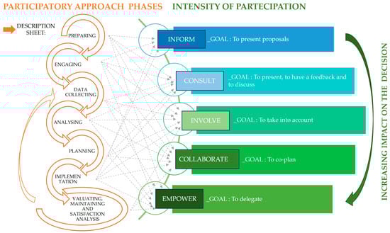
Figure 1.
Participatory approach and intensity of participation (adapted from: Spectrum of Public Participation, 2018 [26]).
When addressing the issue of flood risk in land use planning, there is often a lack of historical knowledge of the drainage network including the superposition between the natural (often culvert) streams and the urban (artificial) conduits; but, at the same time, it is increasingly important to consider the perception of risk of those who inhabit the territory, its historical memory, and vision of the future. The qualitative approach can be useful to understand flood impacts where the lack of objective/numerical data limits the implementation of hydraulic–hydrologic modelling. Qualitative and participatory methods enable researchers to better understand the underlying causal links between interventions and how and why things happen the way they do [43].
First of all, the methodological approach proposes a “description sheet” in order to support the phase of collecting useful information for planning urban resilience to climate change. It is structured in three parts. The first one analyses “Urban Land Use”. This section provides a brief description of the context, its main planning tools (with particular regard to local and basin planning tools), and specifies some information regarding: open spaces (public/private green areas, blue-areas/water, and agricultural areas), the urbanized fabric (residential, industrial, mixed, brownfields, etc.), and population density (urbanized areas and sites under development). The second part is dedicated to some climatic data, namely: the climatic zone, total annual rainfall, average annual temperature, and flood or flooding events over the last 30 years. These two parts concern the quantitative analysis of the approach. The third part, named “Focus on Engagement Context”, addresses the following topics: the stakeholders already involved, the municipality’s confidence level in participatory processes, the already anticipated drivers and barriers, foreseen actions and the engagement process, and the expected results. This part, to be filled in before starting the participatory process, facilitates reasoning on some relevant aspects to be considered in the design of a participatory process tailored to the social, cultural, and territorial characteristics of the context under study. In particular, it is necessary to collect information on the general level of participatory application at “moment zero” and, therefore, on how much the whole territory is aware of the dynamics and mechanisms of participation: does the local authority currently already use participatory techniques to involve the local community, and which stakeholders are already involved in processes with similar topics? Other aspects to be considered are: the expected results, the drivers and barriers that are expected to be encountered, the engagement techniques that are intended to be used, and the planning of activities.
Secondly, once the composition of the working group has been clarified, the stakeholders are characterized in order to better understand their role and their contribution within the process. The role refers to the degree of participation that is intended to be achieved, which can be expressed through the well-known metaphor of the ladder (in information, consultation, involvement, collaboration, and empowerment). As shown in Figure 1, the methodological approach refers to 5 levels of engagement that define the public’s role in participatory processes [26]. “The choice of participation level is closely tied to the impact research will have in real world settings” [44].
However, it is important to consider how the intensity of participation may also vary in relation to the specific planning phase (preparing, engaging, data collecting, analysing, planning, implementation, evaluating and maintaining, and satisfaction analysis). In particular, “during each and all phases of research, decisions must be made about which tools and methods will produce the desired level of participation” [45]. Some authors state that if participation takes place in the very early stages of the design process, participants will have the opportunity to influence decisions more, thus authorities and technicians will be able to make effective use of local knowledge and skills and social learning will be stimulated [46].
Stakeholder participation does not constitute a phase in itself but is conceived as an element to be considered in each phase. From the initial stages of the project, the information obtained thanks to participation can be integrated with accurate analysis of the literature, the territory (also linked to the hydraulic aspects, given the focus), zoning, and the relevant planning tools.
Furthermore, as introduced previously, where archival data are not present, participation supports information gathering. Lastly, the involved stakeholders actively contribute to the co-planning and co-design of activities; they participate in defining where and which SUD strategy or technology needs to be installed to be more effective in the territory. Their contribution is crucial as stakeholders are able to spatially identify criticalities of the territory, for instance, by localizing flooded and green areas. Consequently, they are easily able to suggest places and priorities where it is necessary to intervene.
In participatory planning processes, to guarantee the real involvement of all the actors and ensure that they discuss issues constructively and reach results in a short time, it is necessary to give everyone the opportunity to express themselves/to speak. Existing facilitation techniques are indeed aimed at ensuring that: everyone is adequately informed; all participants are able to listen and understand each other; the involved stakeholders are put in a position to arrive at shared solutions or, in any case, to openly address conflicts. Innovative techniques are needed to design participatory processes as relationships between stakeholders are becoming increasingly complex in today’s world [47]. With a clear methodological approach, it is necessary to identify, on a case-by-case basis, the qualitative/quantitative techniques deemed suitable for managing the participatory process. The techniques used can then be chosen based on the duration (specific or permanent debates), the audience (large or limited), the level of interaction (limited or extensive), and on the specific issues and problems to be addressed and whether the framework is applied ex ante (as part of a definition or design process) or ex post (as part of an evaluation). As regards the specific tool to be used, the possibilities and combinations are many and depend on the specific objective to be achieved [44]. Therefore, techniques and tools must be selected not only when the nature of the problem to be addressed, the objectives of the research, and the degree of involvement of the stakeholders are clear, but also when the sociocultural context of the case study is clear as well. Indeed, innovating means proposing solutions that can be achieved in the relevant contexts, not necessarily the most technologically advanced ones.
4. Case Study
Sampling strategies for quantitative methods are generally well established and based on probability theory. In contrast, for the qualitative methods, there are no clear guidelines for sampling strategies, though it is generally assumed that samples for qualitative inquiry are intentionally selected to produce “information-rich” cases [48]. There are numerous purposive sampling designs. In the proposed approach, the selection of case studies is carried out following the criterion of maximum variation in order to document unique or different variations that emerge through adaptation to different conditions and to identify important common patterns that cut across these variations [49].
The research therefore selects three Italian cities: Brescia, Genoa, and Matera, physically located in three very different territorial contexts and whose participatory approaches are at different stages of development. In all three cases, the common goal is to adopt a participatory approach, involving local stakeholders and the community in raising awareness of the various benefits of SUDs in urban settings. Since 2014, the Municipality of Brescia has had a dedicated office for participatory processes (the Urban Center) that, according to the recent adoption of the climate transition strategy, promotes participatory actions involving all areas of the city. In Genoa, the administration has several ongoing participatory processes, for example, on the themes of circularity or tourism. However, a participatory process related to sustainable urban drainage as a resilience strategy does not yet exist. In Genoa, the focus is therefore on engaging the local community in sustainable urban drainage applications within a specific urban context Matera’s participatory activity aims to foster collaboration and dialogue between stakeholders and local authorities, addressing action priorities and reducing hydraulic risks in a selected area. Full awareness of hydraulic risk is considered crucial for implementing corrective actions that will notably impact future urban planning decisions.
4.1. The Case Study of Brescia: Co-Mapping and Co-Construction of Knowledge in a Well-Established Context of Participation
This case study aims to investigate how to address climate change issues in a local context where a city has already experienced participatory projects with the local communities. The goal is to integrate specific topics, such as climate change and resilience, into the well-established participatory process that has evolved over the years. Brescia is situated in the northeastern part of the Lombardy region—geocode standard NUTS 2 in the Nomenclature of Territorial Units for Statistics (NUTS)—and serves as the chief city of the province (NUTS 3), holding the position of the second most populous province in Lombardy. The city and its surrounding areas bear a notable industrial imprint. Environmental concerns stemming from industrial development, including pollution problems, have become central to land development and regeneration policies. The prevalence of sealed soil poses challenges, leading to flooding issues and the urban heat island phenomenon. In extreme weather events, inadequate drainage of rainfall water into urban networks results in flooding and damage. Figure 2 reports the description sheet applied to the Municipality of Brescia [50].
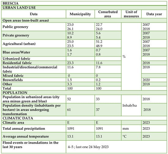
Figure 2.
Brescia’s description sheet describing urban land use data and climatic data.
Over the past decade, Brescia’s Urban Center, a municipal office dedicated to active participation, has involved various stakeholders and the local community in the urban design process and discussions on public policies. The Center possesses in-depth knowledge of stakeholders and interests in the Brescia territory. For example, between 2016 and 2018, it conducted a survey of Brescia’s cultural system to identify places considered relevant for urban renewal and regeneration by the local community.
To address climate change, the municipal authority has endorsed the climate transition strategy (CTS) as the primary programmatic tool to achieve ambitious ecological transition goals (the Un filo Naturale project, funded by Cariplo). The strategy emphasizes a participatory process, engaging local communities in co-planning actions to foster a shared vision for the future and promote effective co-responsibility for integrated and sustainable development. Managed by the Urban Center of the Municipality of Brescia, this aspect of the CTS identifies “small projects” for the public city in collaboration with active local communities. Collaborative efforts with the Urban Center aim to explore the potential positive synergy between proposals for nature-based solutions and the social dimension, evaluating how a participatory approach can enhance socioecological effectiveness. This ambitious goal involves a collaboration between the Urban Center and the local university, adopting a community-based research approach.
The process was structured into two distinct steps, and each step was further divided into phases to effectively manage the project timeline, funding requirements, and administrative aspects. The Urban Center continues to serve as the official liaison in the participation process, with scholars providing support to the steering committee that guides the participatory process. They observe the ongoing dynamics from an external standpoint, pinpointing challenges that need to be addressed and resolved in preparation for subsequent activities. Recognizing the importance of collaboration with neighbourhood councils, city associations, district gatekeepers, and local communities, the Urban Center in Brescia organized a participatory process aimed at identifying “public spaces to be activated” by local communities.
Target group identification is fundamental to engaging active local communities in co-mapping spaces. Over 600 contacts from the Urban Center participation database were clustered into thematic areas. The contacts were analysed based on primary categories reflecting not only the stakeholder’s scope of interest but also the legal form of the entity and its level of influence on the project. The mapping of stakeholders was verified by the municipal administration, providing opinions on which subjects should be prioritized in the project. The combined influence and interest analysis was valuable in understanding how to encourage the involvement of stakeholders who may not typically participate but could significantly influence the results. The most active subjects in proposing co-mapping actions were those interested in “social inclusion and participation”, followed by those interested in the “creativity and attractiveness” of the city and in the “environment and sustainable mobility”.
The co-mapping activity took place in collaboration with local communities during the summer of 2022. Open meetings, initiating the participatory process, were conducted between May and June, with events distributed across various areas of the city. The workshops aimed to identify disused, underused, or problematic public spaces that could be “activated”, transforming them into “active spaces” through urban redevelopment actions with a focus on climate and social resilience. A “space proposal sheet” was filled in by all the participants.
During the meetings, the local communities were encouraged to envision the creation of new meeting squares, small urban oases, areas for play and relaxation, gardens for biodiversity, rain-absorbing “sponge” areas, paths, shaded and cool spaces, and more. The goal was to foster urban spaces where nature and community, working in harmony, could collectively enhance social interactions and improve both sociality and climate resilience, as outlined in the CTS Active Spaces Report for 2022.
The “space proposal sheet” served multiple purposes, including gathering information on the local communities’ areas of interest, such as physical and contextual characteristics, urban planning, and environmental issues. Additionally, it aimed to stimulate reflection among local communities on the potential and redevelopment objectives of the areas. The sheet encouraged considerations about the subjects involved in the space design process, its management, and the beneficiaries of the spaces. Representatives from neighbourhood councils and members of third-sector associations played a significant role in the process.
In total, fifty-six areas were identified and georeferenced throughout the town. Among these, twelve space design proposals suggested the incorporation of water management systems in response to changes in climatic conditions. Eleven proposals addressed biodiversity in space regeneration, and seven proposed de-paving actions. However, only thirteen areas were considered fully eligible by the municipality, and only four of them were considered entirely suitable (Piazza Verde-Carmine, Viale Piave a Colori, Piazzetta Torricella, and Una via per tutti-Casazza). After an open discussion among the proposers, the politicians selected two areas (Piazza Verde-Carmine and Viale Piave a Colori) due to resource constraints.
The second step consisted of the co-design process. Following the verification of the availability of resources to implement the two pilot projects, the Urban Center reactivated the steering committee (composed of members from the Urban Center, the university, project-appointed consultants, and some gatekeepers), focusing activities on co-design workshops for the two pilot areas (mapping and design labs). Figure 3 shows the two steps of participatory process developed in Brescia.
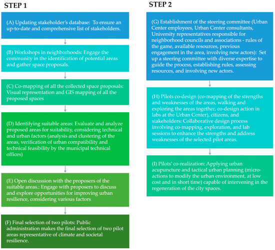
Figure 3.
Phases and activities developed in the participatory process in Brescia.
It is important to emphasize that the second step keeps the compilation of the “space proposal sheet” active and maintains a listening position towards local communities and residents interested in contributing to the design of two spaces. In this co-design phase, the clear need to facilitate communication and interaction with the community becomes evident.
Therefore, after an initial workshop phase where challenges and strengths were discussed, and following a neighbourhood walk aimed at sharing the residents’ perceptions of these places, the steering committee decided to ask each participant involved in the co-design process to choose a word describing the “place in the present” and an evocative word for the “place in the future”, along with an image of a public space that reflects the features they would like to see realized in the pilot space.
Respecting roles is crucial in this collaboration. The Urban Center must maintain its role as the central hub of participation, with its employees serving as the face of participation and actively preserving their role and public image. The trust accumulated over years of work is a valuable resource for the development of public policies in the city of Brescia. University researchers are tasked with training and supporting Urban Center facilitators, assisting them in understanding technical challenges, and developing simplified language. This language should not only align with scientific reasoning but also be able to interface with local communities in the most accessible way possible. In many cases, the challenge is to find innovative communication methods. Nevertheless, it was deemed crucial to actively assisting the office in identifying target groups through a critical reassessment of the contacts already present in the municipal database.
4.2. The Case Study of Genoa: Engagement and Participation in an Evolving Context
In Genoa, the case study proposed for URCA! sees the development of an action specifically dedicated to the engagement of local communities on the topic of SUD application in the urban context considered.
The Municipality of Genoa has worked on the project since its drafting phase, signing a letter of intent at the time of the presentation of the project. The project does not fit into a participatory process already initiated by the administration, but the Genoa University team, in consultation with the public administration, has established ad hoc working groups, consistent with the methodology of community-based participatory research. The process is ultimately aimed at raising awareness in the population regarding the various benefits of introducing SUDs into the urban environment. The participatory process seeks to integrate, in an environment of co-responsibility, the technical know-how of experts and local authorities with the pool of local community knowledge, to co-build a strategic vision of the study area, of possible areas of investment, and ways to exploit available resources.
Genoa, located in the northwest of Italy, is the chief town of the Metropolitan City (NUTS 3) and the region of Liguria (NUTS 2) as well. The National Statistical Institute of Italy (ISTAT) classifies Genoa as a “coastal mountain” territory (due to the presence of elevations above 600 m). Genoa, squeezed between the sea and mountains, with its characteristic upside-down π shape, is a polycentric city due to morphological (about 30/42 km of coastline and two valleys perpendicular to it) and historical factors. Genoa is a port city by definition, with a strategic location overlooking the Mediterranean that makes it an attractive and generative hub of economic activity and employment, with the associated consequences for the quality of life and work of the local communities. In recent decades, Genoa has no longer been just a commercial–industrial hub but is slowly adapting to become a tourist destination. By analysing planning tools, the municipal urban Plan PUC (Piano Urbanistico Comunale; currently in force in its updated version since 2015 [51]), describes the territory as marked by heterogeneous hydrogeological conditions. Indeed, about 100 hydrographic basins characterized by mountain streams with strong acclivity can be defined in the municipality. Critical elements can be traced to the conditions of high hydraulic risk in the stretches close to the mouths of the main watercourses, due to the often highly inadequate size of the riverbed sections resulting from artificialization works (e.g., sealings/culverts, detour, and narrowing). To these must be added the waterproofing of some stretches of the territory, a consequence of uncontrolled urbanization in the 1960s, which makes flood events more rapid. Another critical factor: slope instability, which contributes predominantly to the vulnerability of urbanized areas on the valley floor to flood risk. In this vein, the PUC promotes specific works for soil and hydrogeological defence and enhancement, including encouraging the use of SUDs. Figure 4 shows the description sheet developed for the Municipality of Genoa.
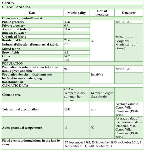
Figure 4.
Genoa’s Description sheet describing urban land use data and climatic data.
The participatory process developed in the research focuses on City Hall II—Centre West—Sampierdarena district. By consulting the basin plan: the features of the study area determine that it is subject to a certain variability in susceptibility to hydrogeological instability (even up to medium-high), as well as geological (up to medium) and hydraulic (up to very high) risk. Almost the entire plain portion of the area is potentially floodable, especially where urban traffic flows are concentrated. Specific critical issues are almost total soil waterproofing, the sealing of minor watercourses, proximity to slopes with modest acclivity, and inaccurate knowledge of the water supply, sewage, and treatment grid.
Specific drivers and barriers to the participatory approach were identified before the implementation of the foreseen actions. Among the drivers, the following facilitating factors have been recognized, including: a proven and effective collaboration between university and administrative bodies, recent flood events (which may thus facilitate motivation for toward a common goal), cooperation with a lively body of retailers and local service representatives (who would gladly assume the role of gatekeepers that can be relied upon), a multipurpose room is available, a sense of neighbourhood belonging. Among the barriers, the following hindering factors have been pointed out, including: a very diverse population, both culturally and demographically; the organization of events in the post-pandemic era; and a sense of neighbourhood belonging.
The methodology built by the Genoa university research team, pursuing top-down and bottom-up territorial governance logics in terms of introducing SUDs in an urban environment, integrates a community-based participatory research (CBPR) approach with the model of the quintuple helix of innovation: administration, research, enterprises, population, and associations. According to the participatory approach, the first step was the identification of target groups and the engagement of local actors in the participatory process. In Figure 5, a summary diagram of the quintuple helix of the actors of the main local territorial functions involved and a graphic representation of the participatory process planned and implemented in Genoa is reported.
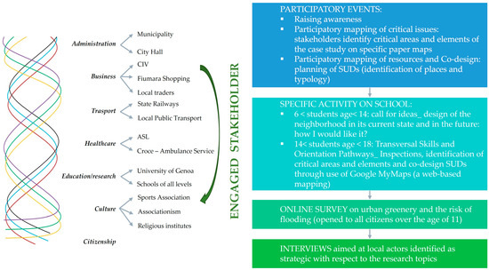
Figure 5.
Stakeholder engagement and activities developed in the participatory process in Genoa.
The Municipality of Genoa and, subsequently, City Hall II—Centre West of Genoa (representing the area under study), took an active role in the participatory process. They formalized the collaboration by granting patronage for the launch event of the participatory process and assumed the role of gatekeepers on behalf of the university research team. In fact, they came into direct contact with the actors in the territory identified as the study area, disseminating the project initiatives. Other actors engaged in the success of the project, are: the company managing the distribution of electricity, gas, and water in the Ligurian territory and a Ligurian engineering consultancy operating in the field of hydraulic, structural, road, and plant design.
In the second step, protocols of engagement and active collaboration differentiated by type of actor were envisaged:
- The administration and water management companies were engaged also upstream of the start of the project; the relationship between the university team and the entities (now consolidated thanks to previous collaborations) is direct and two-way. These actors make up a high-profile working group—both institutional and technical—from which the selection of the study area, the methodological structuring of the participatory process, the analysis of its results and, hopefully, the integration with the municipality’s planning tools are derived. The collaboration is characterised by both regular meetings and in-depth interviews with individual representatives.
- The actors of the other territorial functions are engaged according to a methodology that has been set up specifically for the project. Businesses and local communities are part of a public–private working group (4P participation) that meets in thematic focus groups through which they raise awareness of relevant issues and activate co-mapping and co-design spaces; schools of all levels—to confirm the intergenerationally of the methodology—are involved through customised activities according to school grade. As far as the schools are concerned, in compliance with the regulations in force, primary, and secondary school students carry out the activities during school hours directly in the classroom. Students from 6 years of age were involved through a call for ideas on the perception of urban greenery in the Sampierdarena district. Secondary school students located in the study area, on the other hand, take advantage of the University’s activation of specific PTCOs (transversal skills and orientation pathways, which become a tool of deep learning for the students and a strong engagement for the 14–19-year-old target group regarding the research world). During the first activities they will be involved in mapping through the parallel use of a paper map and the Google MyMaps platform, where they then report all critical issues, both from the point of view of urban greenery and the risk of flooding. The second activity, on the other hand, focuses on the design and planning of sustainable urban drainage systems (SUDs). Furthermore, an online survey opened to all inhabitant (over the age of 11), has been launched for three months and specific interviews were conducted with strategic stakeholders with respect to the research topics. A detailed description of the Genoa participatory process is provided in [52].
4.3. The Case Study of Matera: Co-Mapping and Innovation Technologies to Activate a Dialogue between Stakeholders and Local Authorities
This case study investigates the use of a co-mapping approach also utilizing innovative technologies, including a digital twin, to enhance communication among institutionalized stakeholders. It aims to support both vertical and horizontal governance processes essential for effective territory management in the risk areas of Matera. The focus is on emphasizing priority actions and interactions associated with planning decisions.
The area is situated in Matera, one of the two provinces of the Basilicata region (NUTS 2), covering an area of around 390 km2 with a population of about 59,748 inhabitants (ISTAT 2021). The Municipal administration has always welcomed new challenges, aspiring to sustainable, accessible planning and with an eye towards the valorisation of cultural heritage. Coherently with the proposed methodology, in the first phase of the analysis of the case study, the description sheet is compiled. In Figure 6, the urban land use and climatic data are illustrated in the description sheet for Matera.
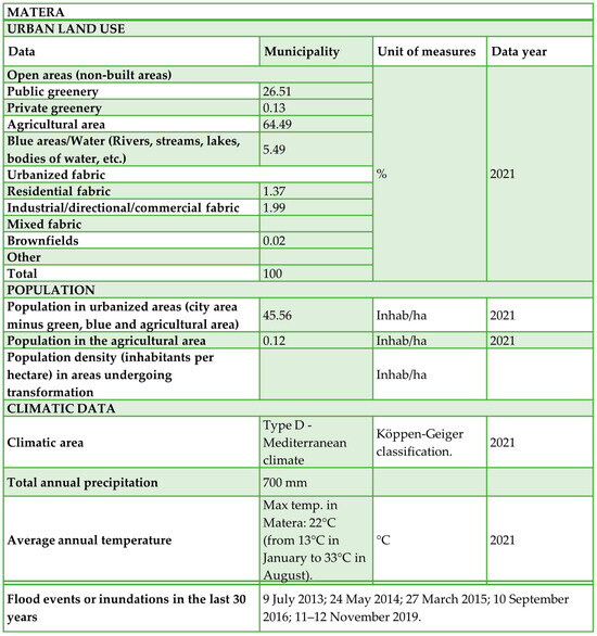
Figure 6.
Matera’s description sheet describing urban land use data and climatic data.
The selected case study mainly concerns the area of the former Padula-Barilla pasta factory and the adjacent popular district of Piccianello. During the 19th century, this neighbourhood underwent significant urban development, marked by the construction of multi-story buildings, eastward expansion with new infrastructure, roads, public services, and the establishment of steam factories, including a mill for producing various types of pasta and bread. Currently this area (Ex-Pastificio Padula-Barilla) spanning approximately 34,000 m2, is in a state of abandonment and stands as the pivotal focus for a substantial urban regeneration project outlined in the local masterplan. An ambitious project, backed by the Po-Fesr Integrated Territorial Investment (ITI) programme for the years 2021–2027, seeks to establish a new and substantial urban centre development in line with the provisions of the sustainable urban mobility plan. The enhancement of accessibility across the area will facilitate the reclamation of a significant portion of public spaces. This redevelopment initiative acts as a catalyst for the social and economic revitalization of the neighbourhoods, aligning with the comprehensive redevelopment of the stadium area, including the modernization of sports facilities and related services.
Furthermore, the Matera municipal administration, in collaboration with the House of Emerging Technologies (the scientific partners of the project are the University of Basilicata, the Polytechnic of Bari, and the National Research Council) has initiated the creation of an Urban digital twin of the city to support intervention policies in terms of its various assets. Within this interdisciplinary research group, the University of Calabria-University of Basilicata focuses on the mapping and monitoring of surface runoff and the risk of urban flooding and will apply the use of this technology to support the decision-making process in the case study of the Ex-Pastificio Padula-Barilla [53]. Figure 7 illustrates the framework of the participatory process in Matera including the list of the main activities, analysed elements, engaged stakeholders, and expected outcomes.
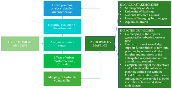
Figure 7.
Activities, analysed elements, engaged stakeholders, and expected outcomes of the participatory process in Matera.
As a matter of fact, this “co-participated mapping activity” faces a challenging aspect as its primary objective is to develop effective and integrated mapping (using a digital twin model). This action aims to foster cooperation and communication among institutional stakeholders and local authorities, also facilitating the establishment of a plan able to mitigate the hydraulic risk in the area. Given the strategic economic investment and interests associated with the redevelopment of this city area, it is imperative for all stakeholders to have a comprehensive understanding of the hydraulic risk prevalent in Matera. This awareness is fundamental for implementing the required corrective measures, which will strongly influence future urban planning decisions.
5. Drivers of and Barriers to a Participatory Governance Approach to SUDs
The research study, starting from an analysis of emerging drivers and barriers of recent significant studies on SUDs application, emphasizes the identification of drivers and barriers in the case studies by means of specific indicators. Table 1 reports the main significant studies on drivers and barriers on SUDs deployment.

Table 1.
Most significant studies on SUDs and their barriers and drivers in the last 5 years.
Based on the literature analysis reported in Table 1, a matrix of barriers/drivers to participation in SUD planning is developed and illustrated in Figure 8 and Figure 9. The proposed 26 indicators to assess drivers and barriers include both indicators from the literature (already assessed in previous studies) and innovative (specifically identified in this study) indicators. The proposed indicators are organized into the following evaluation parameters: policy and legislation, governance, involvement, and resources. In the developed barrier–driver matrix, each proposed indicator is analysed for the level of participation (just started, ongoing, and advanced) corresponding to the case study (respectively, Matera, Genoa, and Brescia) and with respect to three levels of confidence (low, medium, and high) reported in the matrix, respectively, as light, normal, and dark colours. Figure 8 reports the developed matrix of barriers to (B) and drivers of (D) participation in SUD planning for the policy and legislation and governance parameters. Figure 9, similarly to Figure 8, reports the developed matrix of barriers to/drivers of participation in SUD planning for the following parameters: engagement and resources. The innovative indicators depicted in this study are: quadruple helix, university role, post-COVID19 era, intergenerationality, interdisciplinarity, trust in administration, and technological tools. Concerning the university role indicator, a certain pressure on universities to pair teaching and performing research with providing contribution to communities and territories, known as the third mission, has recently been observed [60]. Globally, major barriers identified in the three case studies include sectoral silos or a siloed mentality, path dependence, limited time availability, and a lack of guidelines for engaging local actors. On the other hand, drivers encompass the quadruple helix model, the involvement of universities, interdisciplinary approaches, dedicated financial incentives and resources, as well as the utilization of technological tools and human resources.
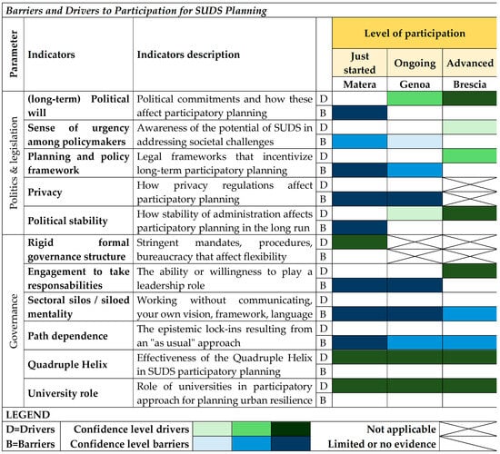
Figure 8.
Matrix of Barriers to and Drivers of Participation in SUD Planning for the Evaluation Parameters: Politics and Legislation and Governance.
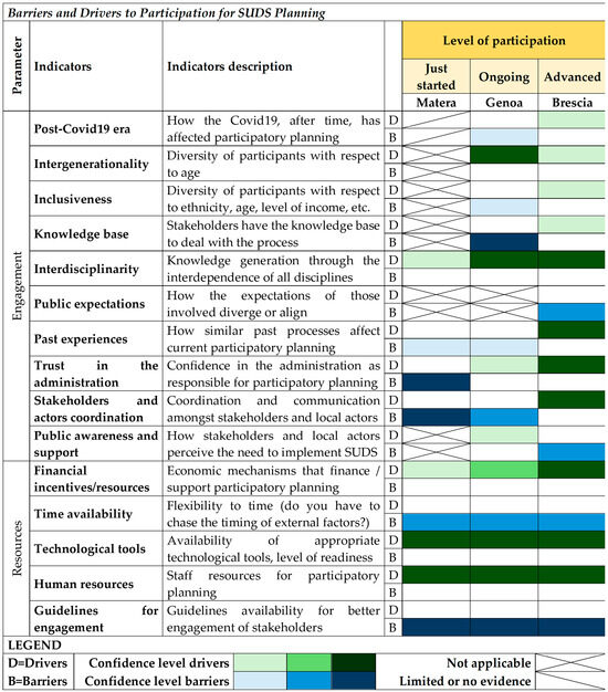
Figure 9.
Matrix of Barriers to (B) and Drivers of (D) Participation in SUD Planning for the Evaluation Parameters: Engagement and Resources.
Regarding the parameter “Policy and Legislation”, the three case studies are depicted as rather heterogeneous in terms of the barriers and drivers encountered (Figure 8). In contrast, some homogeneity can be detected at the level of the “Governance” parameter: all three case studies report that SUD participatory planning is hindered mainly by the siloed mentality and path dependence of local governments (Figure 8). In this regard, it is worth noting that SUDs are multifunctional strategies that contribute to various ecosystem services. This means that they require the contribution of both urban planners, practitioners who deal with green areas, and those who design urban drainage systems, etc. In the three case studies, all these aforementioned competences often belong to public administration departments that are independent of each other. Furthermore, within these departments there is a certain resistance to change, in favour of more traditional urban planning approaches (based almost exclusively on grey infrastructure and the enhancement of the built environment for economic growth). Results plotted in Figure 9 confirm that the involvement of the four helices (of the quadruple helix model) is a win–win enabling factor in terms of bringing about innovation in planning practices and stimulating a revision of typical governance mechanisms, while the unavailability of guidelines for stakeholder engagement is a significant barrier for all three cases studies Therefore, it is time for local administrations to draft guidelines on how to effectively engage stakeholders and local actors (which have been almost entirely absent, so far).
Figure 9 reveals that the three case studies demonstrate very different results at the level of the “Engagement” parameter. This can be explained by the extent to which each territory habitually uses participatory planning processes, and also, by the different state of advancement of the activities. Regarding the “Resources” parameter, the case studies show how challenging pursuing medium- to long-term objectives can be when depending on the timing of external factors such as: election cycles (which strongly affect stability and political commitment beyond the short term); the start and end period of a funded project; and people’s time (working and studying, which also changes with the season). But the three case studies also make it clear that the presence of properly trained human resources (in interdisciplinary teams), the availability of technological tools, and the necessary funding can positively drive the progress of the process.
Secondly, the matrixes of drivers and barriers are analysed according with the level of participation (just started, ongoing, and advanced) in order to depict the evolution of the overall process. In particular, in the case study where the level of participation is advanced, co-mapping work is certainly of interest. The activity carried out undoubtedly benefits from the presence of the climate transition strategy and the availability of resources specifically dedicated to local community engagement on topics also relevant to the URCA! project. The whole engagement process was understandably conditioned by the institutional role necessarily played by the Municipality and by the Urban Center. This is due to the need to manage the timeline especially in relation to administrative commitments and deadlines (elections in May 2023), as well as the presence of economic resources tied to specific time deadlines of other ongoing projects. The activation of local communities had an excellent outcome especially thanks to the now consolidated credibility that the Urban Center has in the Brescia area. On the one hand, the significant number of “spaces to be activated” identified by local communities clearly highlights the interest in and willingness to be involved in decision-making processes. On the other hand, it reflects an understandable difficulty in completely carrying out the assigned task and/or the limited capacity in identifying areas with characteristics that can be considered suitable for a transformation. In Brescia, the reactivation of co-mapping and co-design activities after the local elections led to the turnover of some inhabitants, reopening discussions on some of the previously agreed-upon decisions. Some inhabitants attempted to modify the selected areas for co-design and even the project themes.
The participatory process being implemented in the ongoing case study presupposes the activation of a close and continuous collaboration between the various actors representing the main territorial functions that exist on the target territory. The Sampierdarena neighbourhood is very diverse in sociocultural, urban, and territorial terms. Its various sociodemographic nuances create an obstacle to the involvement of new residents, who do not feel the same sense of belonging to the area as the ‘old’ ones, i.e., those who have lived in the neighbourhood for more than 10 years. The adopted participatory process represents, for the Municipality of Genoa, a new methodology of governance that has not yet been developed. In fact, the project interfaced with the institution, i.e., the Municipality and the local City Hall, which acted as intermediaries between the project team and the identified stakeholders, and also with the population itself. During the early stages of the participatory governance process developed, a number of institutional and procedural barriers emerged, which initially slowed down the participation process. Institutional barriers are decision-making policies in the form of regulations and norms that hinder participatory dynamics, but also the university’s and the administration’s own work schedules, which often do not coincide. One was confronted with a lack of flexibility and bureaucratic processes typical of local administration in Italy, as opposed to the more rapid actions generally taken by university bodies, often encountering: time delays, rules and regulations to be followed, privacy to be respected. An important contribution in terms of participation was sought among the young people, in particular students. In fact, for children and teenagers, three different activities were structured for three different age groups, with good results. However, the topic of urban resilience with respect to climate change and SUDs is not often addressed in schools. This aspect, together with the overlapping commitments and deadlines of the schools, constituted critical issues that have been carefully explored.
The just started case study highlights one of the most recurring challenges in the participatory process, stemming from political instability within the local administration. The lack of strong institutions leads to a rotation of different figures overseeing activities, posing a vulnerability to the participatory process and overall decision-making processes. Changes in leadership may not only result in pauses, suspensions, or even the cancellation of ongoing or initiated activities, but also present a significant risk of losing available economic resources, as well as prolonged exposure to risks for the population. This condition of weakness is typically accompanied by a general lack of trust in the participatory process, even when institutionalized. This lack of trust is fuelled by inexperience in managing a process that involves various institutional actors both horizontally and vertically. This barrier appears to be one of the most relevant in the Italian context, which struggles to overcome institutional silos to effectively implement adaptation strategies to climate change [61]. Knowledge sharing remains a challenge, as does the sharing of data supporting the use of innovative technologies. The ambition of the Matera case study thus grapples with social limitations inherent to the transformative capacity of a city. This capacity relies on the collaborative efforts of various public and private actors working together to absorb new knowledge and innovations.
6. Conclusions
The research carried out in the present paper introduces operational guidelines to support an integrated participatory process for planning urban resilience to climate change. The drivers and barriers encountered in the participatory process are analysed and discussed for three case studies in Brescia, Genoa, and Matera (IT). The three case studies detail the participatory activity in different ways. Based on the different participatory experiences of the three case studies, the present research provides remarkable highlights for stakeholder engagement and the selection of the appropriate ways of interacting with them.
In the case of Brescia, the action fostered the mapping of resources—the spaces to be activated—present in the neighbourhoods. The participatory process was so broad that it involved the entire city. Indeed, local communities were asked to freely report spaces and places “to be activated”, recognizing them as resources for reducing the impact of climate change. The result in the Brescia case led to the reporting of spaces identified for their potential value, but sometimes made the desired interventions unsuitable due to dimensional characteristics, the scale of the proposal, the possibility of transformation, etc. Of the 56 areas identified by local communities, only 13 were considered suitable and fully consistent with the objectives of the CTS. The process of selecting suitable spaces was, on the one hand onerous, for the public administration and, on the other hand, potentially disappointing for local communities who saw the introduction of criteria for selecting areas that were not clearly known a priori. The rules of the game—the economic resources available for the activation of the spaces, the criteria for evaluating the proposals and selecting them—should always be placed at the basis of the participatory action (and co-planning).
As regards the case of Genoa, the choice to involve schools is particularly strategic to encourage the intergenerationality of the participatory process. In many cases, participatory processes are characterized by the prevalence of elderly people and adults. The project group necessarily had to implement participatory processes that were parallel to each other and customized ad hoc (one for local communities through focus groups and the other more creatively with young people) which would then have to be reunited through the mediation of facilitators. In the case of Genoa, the first focus group helped to transform the local community’ mental map, i.e., the individual perception of the critical issues linked to climate change in the neighbourhood (for example, the perceived risk of flooding), into a spatial map capable of describing the places vulnerable to flooding in the neighbourhood through a mechanism of sharing knowledge about the places (the inhabitant is the holder of the memory of events that occurred in a place) and of the co-construction (community-based participatory research) of knowledge.
In the case of Matera, the participatory process is currently limited to institutional actors. The formal nature of the discussions therefore prevails. The output of interest could be the co-construction by the institutional actors of a systemic map—understood as a complex representation of the reality of Matera—capable of supporting the vertical and horizontal governance process necessary for the correct governance of the territory in the areas of Matera that are at risk, highlighting priority actions and interactions between plans.
In all three case studies, the university working groups were “conditioned” in their action by the presence of the local authority. Even if the role of universities in the participatory approach to planning urban resilience is broadly recognised as a driver for all levels of participation, the relationship between universities and local authorities can be considered both a driver and a barrier. The support of the university in the construction of public policies by highlighting the critical issues arising from climate change and the possible benefits in terms of quality of life linked to the introduction of SUDs is of strategic importance for cities. However, the direct involvement of a university in a local authority’s mechanisms is not easily achievable. Furthermore, in two of the case studies, policymakers supported the presence of universities as an assurance of the participatory process’s quality, with science guiding the decision-making. The pivotal role played by scholars in such processes is essential, enabling policymakers to experiment and implement innovative solutions, while also concentrating efforts on the most promising options in applied research. On the other hand, the understanding of the problems by local communities concerning urban resilience to climate change increasingly requires literacy paths that guide and support the growth and maturation of a strong awareness of the complexity of the choices that local authorities must face in the contemporary city where the land resource is practically completely consumed; the local communities’ requests are numerous and the margins for intervention are limited.
Author Contributions
Conceptualization, M.P. and I.S.; methodology, M.P. and I.S.; validation, A.P., M.P. and I.S.; formal analysis, A.P., M.P., I.S. and R.E.; investigation, M.P., I.S. and R.E.; data curation, M.P., I.S. and R.E.; writing—original draft preparation, A.P., M.P. and I.S.; writing—review and editing, A.P., M.P. and I.S.; funding acquisition, A.P. All authors have read and agreed to the published version of the manuscript.
Funding
This research was supported by the project “URCA!—Urban Resilience to Climate change: Activation of participatory mapping and decision support tool for enhancing the sustainable urban drainage” (CUP D33C220004100) funded by the Italian Ministry of University and Research (MUR) in the PRIN2020 programme.
Institutional Review Board Statement
Not applicable.
Informed Consent Statement
Not applicable.
Data Availability Statement
Updated info on the participatory process actions is available on the online project website: https://prinurca.wordpress.com/ (accessed on 29 February 2024).
Acknowledgments
The support of the Municipality of Brescia, the Municipality of Genoa, and the Municipality of Matera in implementing the URCA! project activities for the selected case studies is gratefully acknowledged.
Conflicts of Interest
The authors declare no conflict of interest.
References
- European Environment Agency. Urban Adaptation in Europe: How Cities and Towns Respond to Climate Change; EEA Report 12/2020; European Environment Agency: Copenhagen, Denmark, 2020. [Google Scholar]
- Zahmatkesh, Z.; Karamouz, M.; Goharian, E.; Burian, S.J. Analysis of the effects of climate change on urban storm water runoff using statistically downscaled precipitation data and a change factor approach. J. Hydrol. Eng. 2015, 20, 05014022. [Google Scholar] [CrossRef]
- Balistrocchi, M.; Grossi, G. Predicting the impact of climate change on urban drainage systems in northwestern Italy by a copula-based approach. J. Hydrol. Reg. Stud. 2020, 28, 100670. [Google Scholar] [CrossRef]
- Galuppini, G.; Quintilliani, C.; Arosio, M.; Barbero, G.; Ghilardi, P.; Manenti, S.; Petaccia, G.; Todeschini, S.; Ciaponi, C.; Martina, M.L.V.; et al. A unified framework for the assessment of multiple source urban flash flood hazard: The case study of Monza, Italy. Urban Water J. 2020, 17, 65–77. [Google Scholar] [CrossRef]
- Palermo, S.A.; Turco, M.; Principato, F.; Piro, P. Hydrological effectiveness of an extensive green roof in Mediterranean climate. Water 2019, 11, 1378. [Google Scholar] [CrossRef]
- Turco, M.; Kodešová, R.; Brunetti, G.; Nikodem, A.; Fér, M.; Piro, P. Unsaturated hydraulic behaviour of a permeable pavement: Laboratory investigation and numerical analysis by using the HYDRUS-2D model. J. Hydrol. 2017, 554, 780–791. [Google Scholar] [CrossRef]
- Cipolla, S.S.; Maglionico, M.; Stojkov, I. Experimental Infiltration Tests on Existing Permeable Pavement Surfaces. Clean-Soil Air Water 2016, 44, 89–95. [Google Scholar] [CrossRef]
- Manso, M.; Castro-Gomes, J. Green wall systems: A review of their characteristics. Green wall systems: A review of their characteristics. Renew. Sustain. Energy Rev. 2015, 41, 863–871. [Google Scholar] [CrossRef]
- Campisano, A.; Modica, C.; Gullotta, A. Long-term experiments for the evaluation of the potential for storm water control of modular blue roofs in Mediterranean climate. Urban Water J. 2021, 18, 33–42. [Google Scholar] [CrossRef]
- Cipolla, S.S.; Maglionico, M.; Stojkov, I. A long-term hydrological modelling of an extensive green roof by means of SWMM. Ecol. Eng. 2016, 95, 876–887. [Google Scholar] [CrossRef]
- Bressy, A.; Gromaire, M.C.; Lorgeoux, C.; Saad, M.; Leroy, F.; Chebbo, G. Efficiency of source control systems for reducing runoff pollutant loads: Feedback on experimental catchments within Paris conurbation. Water Res. 2014, 57, 234–246. [Google Scholar] [CrossRef]
- Turco, M.; Brunetti, G.; Palermo, S.A.; Capano, G.; Grossi, G.; Maiolo, M.; Piro, P. On the environmental benefits of a permeable pavement: Metals potential removal efficiency and Life Cycle Assessment. Urban Water J. 2020, 17, 619–627. [Google Scholar] [CrossRef]
- Torres, L.; Pina, V.; Acerete, B. E-Governance development in European Union cities: Reshaping government’s relationship with citizens. Governance: An International Journal of Policy, Administration and Institutions. Governance 2006, 19, 277–302. [Google Scholar] [CrossRef]
- Brunetta, G.; Ceravolo, R.; Barbieri, C.A.; Borghini, A.; de Carlo, F.; Mela, A.; Beltramo, S.; Longhi, A.; De Lucia, G.; Ferraris, S.; et al. Territorial Resilience: Toward a Proactive Meaning for Spatial Planning. Sustainability 2019, 11, 2286. [Google Scholar] [CrossRef]
- EEA, European Environmental Agency. Nature-Based Solutions in Europe: Policy, Knowledge and Practice for Climate Change Adaptation and Disaster Risk Reduction; EEA Report No 1/2021; European Environmental Agency: Copenhagen, Denmark, 2021. [Google Scholar]
- Cardinali, M.; Dumitru, A.; Vandewostijne, S.; Wendling, L. (Eds.) Evaluating the Impact of Nature-Based Solutions: A Summary for Policy Makers; Publications Office of the European Union: Luxembourg, 2021. [Google Scholar] [CrossRef]
- Palla, A.; Gnecco, I. A continuous simulation approach to quantify the climate condition effect on the hydrologic performance of green roofs. Urban Water J. 2019, 17, 609–618. [Google Scholar] [CrossRef]
- Nazarpour, S.; Gnecco, I.; Palla, A. Evaluating the Effectiveness of Bioretention Cells for Urban Stormwater Management: A Systematic Review. Water 2023, 15, 913. [Google Scholar] [CrossRef]
- Agger, A. Towards tailor-made participation: How to involve different types of citizens in participatory governance. Town Plan. Rev. 2012, 83, 29–45. Available online: https://www.jstor.org/stable/41349079 (accessed on 29 February 2024). [CrossRef]
- Dearden, P.; Jones, S.; Sartorius, R. Tools for Development: A Handbook for Those Engaged in Development Activity; Version 15; Department for International Development (DFID): London, UK, 2002. [Google Scholar]
- Arnstein, S. A ladder of citizen participation. J. Am. Plan. Assoc. 1969, 35, 216–224. [Google Scholar] [CrossRef]
- Davidson, S. Spinning the wheel of empowerment. Planning 1998, 1262, 14–15. [Google Scholar]
- Kindon, S.; Pain, R.; Kesby, M. Participatory action research: Origins, approaches and methods. In Participatory Action Research Approaches and Methods: Connecting People, Participation and Place; Routledge: Oxfordshire, UK, 2007; pp. 9–18. [Google Scholar]
- Luyet, V.; Schlaepfer, R.; Parlange, M.B.; Buttler, A. A framework to implement stakeholder participation in environmental projects. J. Environ. Manag. 2012, 111, 213–219. [Google Scholar] [CrossRef] [PubMed]
- Soma, K.; Dijkshoorn-Dekker, M.W.C.; Polman, N.B.P. Stakeholder contributions through transitions towards urban sustainability. Sustain. Cities Soc. 2018, 37, 438–450. [Google Scholar] [CrossRef]
- International Association for Public Participation. The Spectrum of Public Participation. 2018. Available online: https://iap2.org.au/wp-content/uploads/2020/01/2018_IAP2_Spectrum.pdf (accessed on 4 December 2023).
- Jager, N.W.; Newig, J.; Challies, E.; Kochskamper, E. Pathways to Implementation: Evidence on How Participation in Environmental Governance Impacts on Environmental Outcomes. J. Public Adm. Res. Theory 2020, 30, 383–399. [Google Scholar] [CrossRef]
- Pirlone, F.; Spadaro, I.; Candia, S. More Resilient Cities to Face Higher Risks. The Case of Genoa. Sustainability 2020, 12, 4825. [Google Scholar] [CrossRef]
- Eriksson, E.; Fredrisksson, A.; Syssner, J. Opening the black box of participatory planning: A study of how planners handle citizens’ input. Eur. Plan. Stud. 2021, 30, 994–1012. [Google Scholar] [CrossRef]
- Mathur, V.N.; Price AD, F.; Austin, S.; Moobela, C. Defining, Identifying and Mapping Stakeholders in the Assessment of Urban Sustainability. Loughborough University. Journal Contribution. 2007. Available online: https://hdl.handle.net/2134/5202 (accessed on 29 February 2024).
- Fenner, R.; O’Donnell, E.; Ahilan, S.; Ncube, S.; Vercruysse, K. Achieving urban flood resilience in an uncertain future. Water 2019, 11, 1082. [Google Scholar] [CrossRef]
- Holling, C.S. Engineering resilience versus ecological resilience. In Engineering within Ecological Constraints; Schulze, P.C., Ed.; National Academy Press: Washington, DC, USA, 1996; pp. 31–43. [Google Scholar]
- Holling, C.S. Resilience and Stability of Ecological Systems. Annu. Rev. Ecol. Syst. 1973, 4, 1–23. [Google Scholar] [CrossRef]
- Liao, K.-H. A theory on urban resilience to floods-A basis for alternative planning practices. Ecol. Soc. 2012, 17, 48. [Google Scholar] [CrossRef]
- Dong, X.; Guo, H.; Zeng, S. Enhancing future resilience in urban drainage system: Green versus grey infrastructure. Water Res. 2017, 124, 280–289. [Google Scholar] [CrossRef]
- Godschalk, D.R. Urban hazard mitigation: Creating resilient cities. Nat. Hazards Rev. 2003, 4, 136–143. [Google Scholar] [CrossRef]
- Bertilsson, L.; Wiklund, K.; Tebaldi, I.d.M.; Rezende, O.M.; Veról, A.P.; Miguez, M.G. Urban flood resilience—A multi-criteria index to integrate flood resilience into urban planning. J. Hydrol. 2019, 573, 970–982. [Google Scholar] [CrossRef]
- Hügel, S.; Davies, A. Public participation, engagement, and climate change adaptation: A review of the research literature. In Wiley Interdisciplinary Reviews: Climate Change; John Wiley & Sons: Hoboken, NJ, USA, 2020; Volume 11. [Google Scholar] [CrossRef]
- Paunov, C.; Satorra, S. Engaging Citizens in Innovation Policy: Why, When and How; Science, Technology and Industry Policy Paper 149; OECD: Paris, France, 2023. [Google Scholar] [CrossRef]
- Lejano, R.P.; Haque, C.E.; Berkes, F. Co-production of risk knowledge and improvement of risk communication: A three-legged stool. Int. J. Disaster Risk Reduct. 2021, 64, 102508. [Google Scholar] [CrossRef]
- Haque, C.E.; Azad, M.A.K.; Choudhury, M.-U. Social learning, innovative adaptation and community resilience to disasters: The case of flash floods in Bangladesh. Disaster Prev. Manag. Int. J. 2022, 31, 601–618. [Google Scholar] [CrossRef]
- McIntyre, A. Participatory Action Research; Sage: Newcastle upon Tyne, UK, 2008; Available online: https://journals.sagepub.com/doi/10.1177/1609406920958964#bibr37-1609406920958964 (accessed on 29 February 2024).
- Norad, Norwegian Agency for Development Cooperation. A Framework for Analysing Participation in Development Report 1/2013; Norad, Norwegian Agency for Development Cooperation: Oslo, Norway, 2013. [Google Scholar]
- OECD. Citizens as Partners: Information, Consultation and Public Participation in Policy Making; OECD: Paris, France, 2001. [Google Scholar]
- Vaughn, L.M.; Jacquez, F. Participatory Research Methods—Choice Points in the Research Process. J. Particip. Res. Methods 2020, 1, 13244. [Google Scholar] [CrossRef]
- Newig, J.; Challies, E.; Jager, N.W.; Kochskaemper, E.; Adzersen, A. The Environmental Performance of Participatory and Collaborative Governance: A Framework of Causal Mechanisms. Policy Stud. J. 2018, 46, 269–297. [Google Scholar] [CrossRef] [PubMed]
- Pirlone, F.; Spadaro, I. Gli Strumenti Partecipativi per lo Sviluppo di un Piano di Gestione dei Rifiuti Condiviso; In Verso una Gestione Sostenibile dei Rifiuti nei porti del Mediterraneo. Vers une Gestion Durable des Déchets dans les ports de la Méditerranée; Francoangeli: Milan, Italy, 2020; pp. 1–475. ISBN 9788835106098. [Google Scholar]
- Patton, M.Q. Qualitative Research and Evaluation Methods, 3rd ed.; Sage Publications: Thousand Oaks, CA, USA, 2002. [Google Scholar]
- Palinkas, L.A.; Horwitz, S.M.; Green, C.A.; Wisdom, J.P.; Duan, N.; Hoagwood, K. Purposive sampling for qualitative data collection and analysis in mixed methods implementation research. Adm. Policy Ment. Health 2015, 42, 533–544. [Google Scholar] [CrossRef] [PubMed]
- Data Collected by University of Brescia Research Group Following the “European Green Capital Award 2022 Guidance Note”. Available online: https://circabc.europa.eu/ui/group/c6e126de-5b8c-4cd7-8d36-a1978a2a63de/library/222e941b-31d3-4b09-9a41-30e6a84263b9/details (accessed on 13 January 2024).
- Comune di Genova, Piano Urbanistico Comunale. 2015. Available online: https://www.comune.genova.it/servizi/puc (accessed on 3 December 2015).
- Gnecco, I.; Pirlone, F.; Spadaro, I.; Bruno, F.; Lobascio, M.C.; Sposito, S.; Pezzagno, M.; Palla, A. Participatory Mapping for Enhancing Flood Risk Resilient and Sustainable Urban Drainage: A Collaborative Approach for the Genoa case study. Sustainability 2024, 16, 1936. [Google Scholar] [CrossRef]
- Ermini, R.; Fattore, C.; Zoubi, A.A. Hydromorphic Impact of Matera’s Urban Area. Geographies 2023, 152–167. [Google Scholar] [CrossRef]
- Sarabi, S.; Han, Q.; Romme, A.G.L.; de Vries, B.; Wendling, L. Key Enablers of and Barriers to the Uptake and Implementation of Nature-Based Solutions in Urban Settings: A Review. Resources 2019, 8, 121. [Google Scholar] [CrossRef]
- Sarabi, S.; Han, Q.; Romme, A.G.L.; de Vries, B.; Valkenburg, R.; den Ouden, E. Uptake and implementation of Nature-Based Solutions: An analysis of barriers using Interpretive Structural Modeling. J. Environ. Manag. 2020, 270, 110749. [Google Scholar] [CrossRef] [PubMed]
- Sarabi, S.; Han, Q.; Romme, A.G.L.; de Vries, B.; Valkenburg, R.; den Ouden, E.; Zalokar, S.; Wendling, L. Barriers to the Adoption of Urban Living Labs for NBS Implementation: A Systemic Perspective. Sustainability 2021, 13, 13276. [Google Scholar] [CrossRef]
- Raška, P.; Bezak, N.; Ferreira, C.S.; Kalantari, Z.; Banasik, K.; Bertola, M.; Bourke, M.; Cerdà, A.; Davids, P.; de Brito, M.M.; et al. Identifying barriers for nature-based solutions in flood risk management: An interdisciplinary overview using expert community approach. J. Environ. Manag. 2022, 310, 114725. [Google Scholar] [CrossRef]
- Castelo, S.; Amado, M.; Ferreira, F. Challenges and Opportunities in the Use of Nature-Based Solutions for Urban Adaptation. Sustainability 2023, 15, 7243. [Google Scholar] [CrossRef]
- Ganeshu, P.; Fernando, T.; Keraminiyage, K. Barriers to, and Enablers for, Stakeholder Collaboration in Risk-Sensitive Urban Planning: A Systematised Literature Review. Sustainability 2023, 15, 4600. [Google Scholar] [CrossRef]
- Compagnucci, L.; Spigarelli, F. The Third Mission of the university: A systematic literature review on potentials and constraints. Technol. Forecast. Soc. Change 2020, 161, 120284. [Google Scholar] [CrossRef]
- Bianchi, S.; Richiedei, A. Territorial Governance for Sustainable Development: A Multi-Level Governance Analysis in the Italian Context. Sustainability 2023, 15, 2526. [Google Scholar] [CrossRef]
Disclaimer/Publisher’s Note: The statements, opinions and data contained in all publications are solely those of the individual author(s) and contributor(s) and not of MDPI and/or the editor(s). MDPI and/or the editor(s) disclaim responsibility for any injury to people or property resulting from any ideas, methods, instructions or products referred to in the content. |
© 2024 by the authors. Licensee MDPI, Basel, Switzerland. This article is an open access article distributed under the terms and conditions of the Creative Commons Attribution (CC BY) license (https://creativecommons.org/licenses/by/4.0/).