
Is Poverty Concentrated in Shanghai? Spatial Patterns in Social Housing and Their Implications for Social Equality in Chinese Cities

Abstract
1. Introduction
2. Literature Review
2.1. Poverty Concentration
2.2. Residential Spatial Patterns
3. Methodology
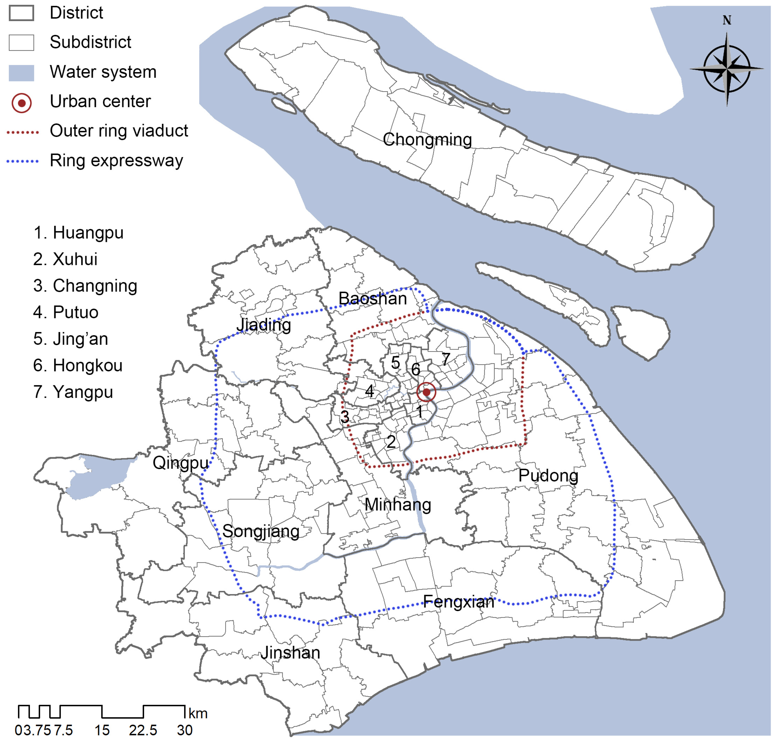
3.1. Study Area
3.2. Data Sources
3.3. Methods
3.3.1. Spatial Autocorrelation Analysis
3.3.2. Location Quotient (LQ)
3.3.3. Mann–Whitney U Test
4. Results
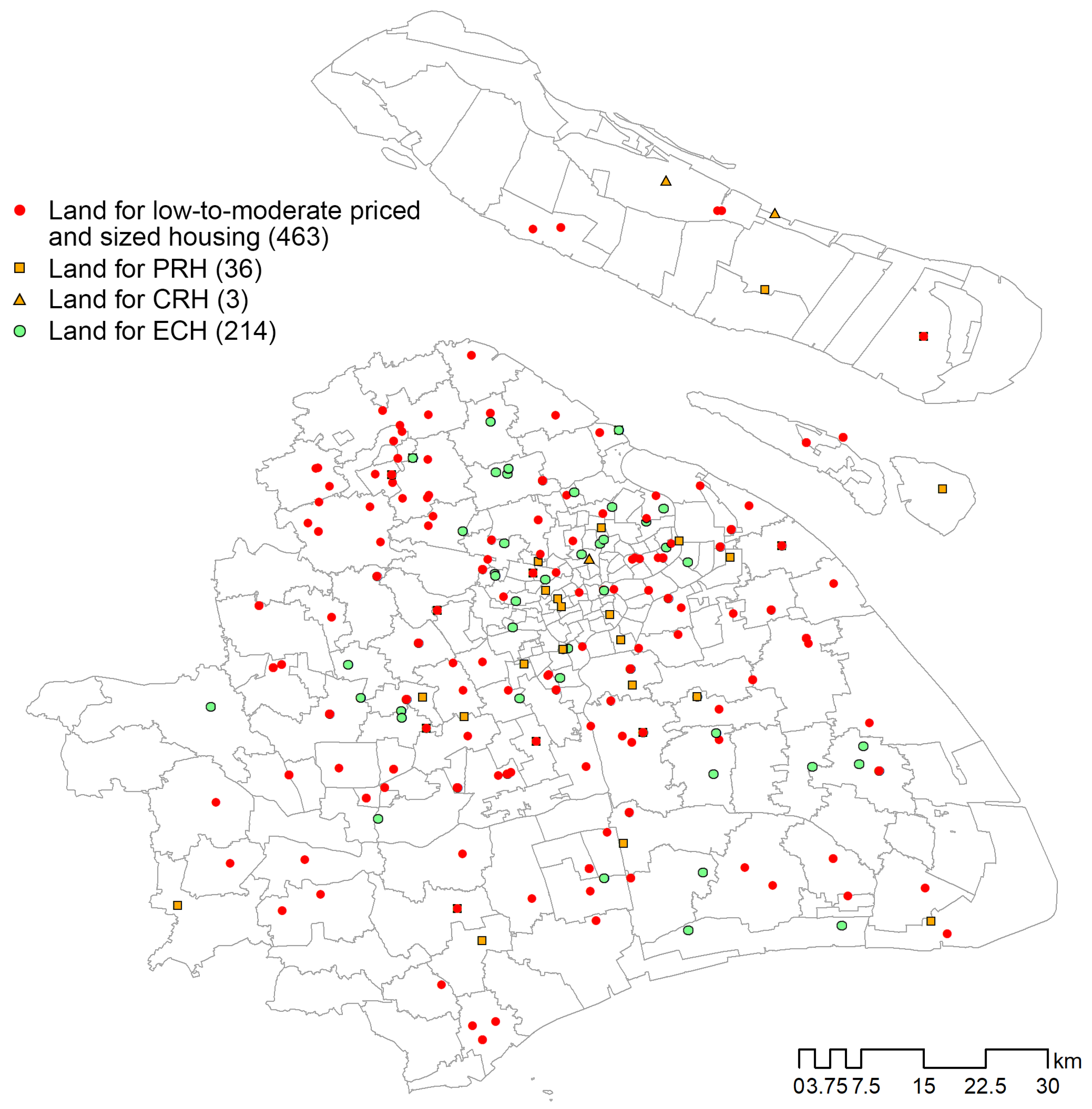
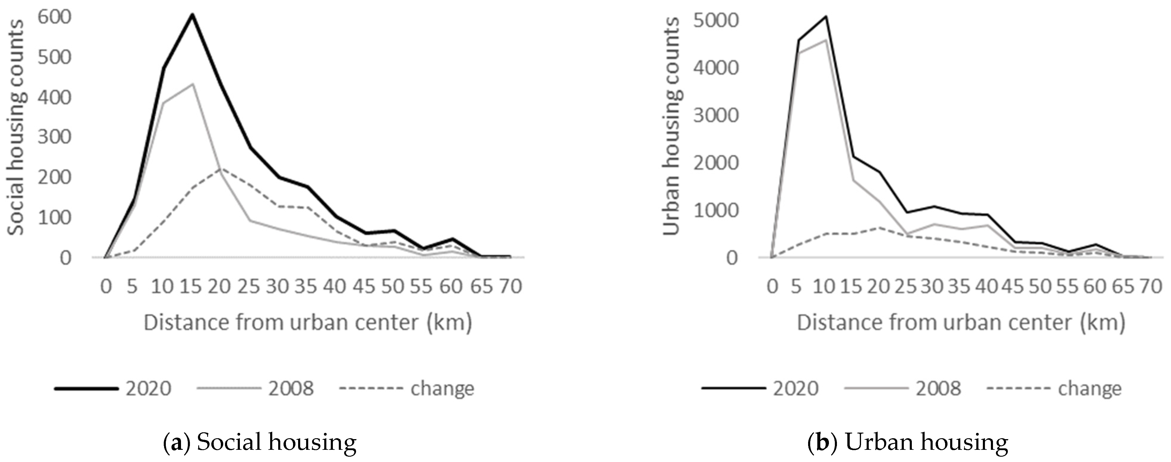
4.1. Spatial Distribution of Social Housing
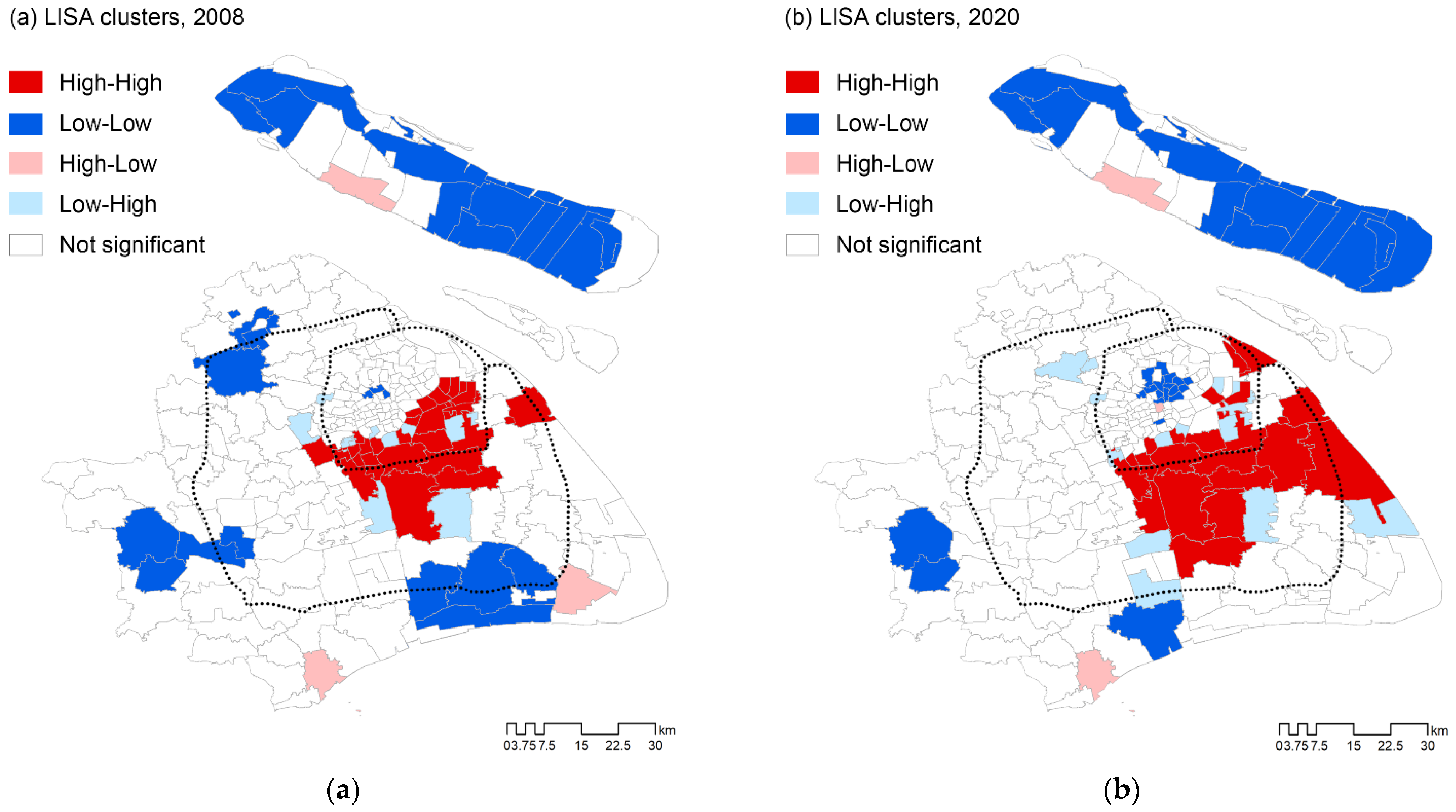
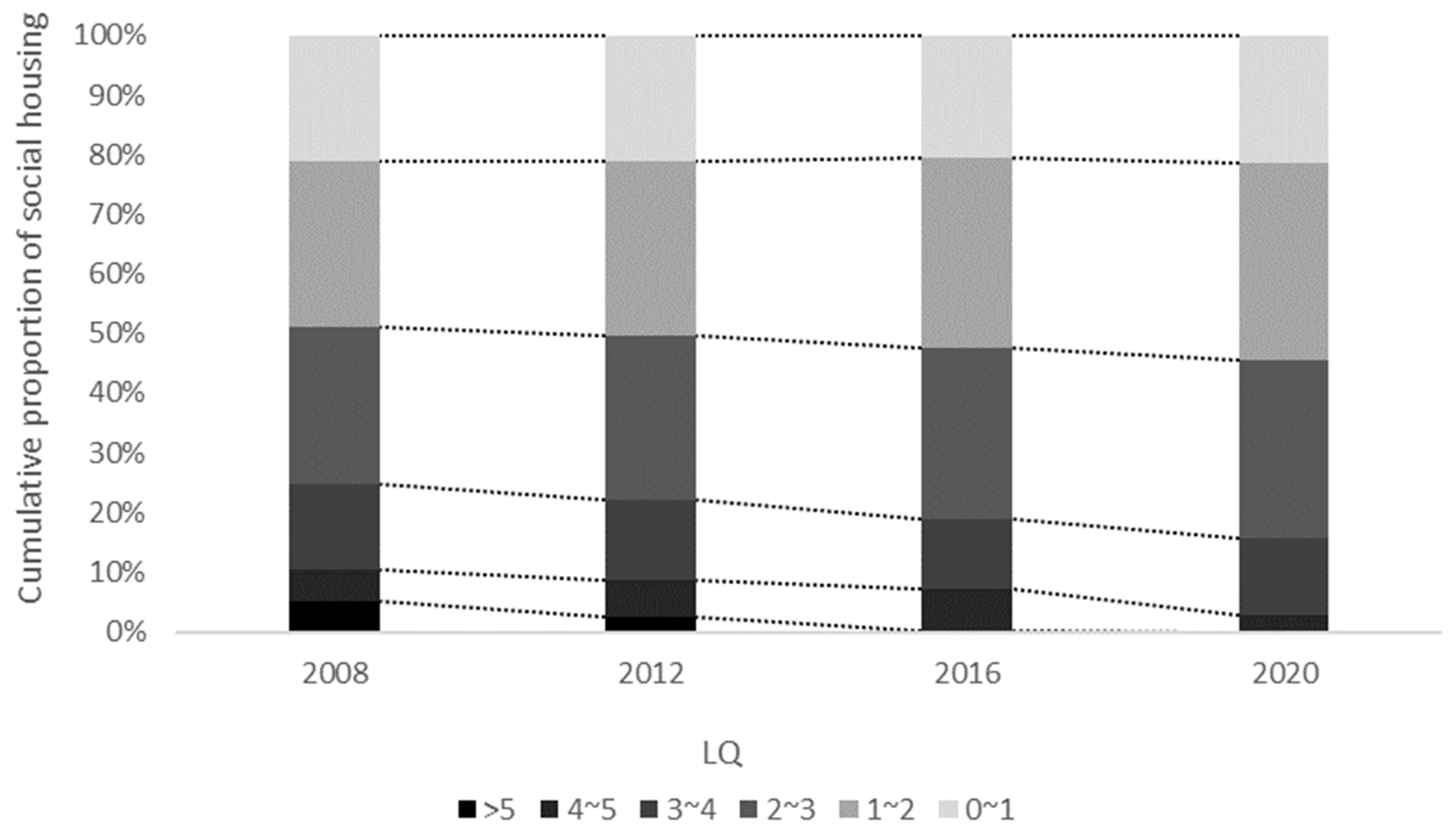
4.2. Spatial Concentration of Social Housing
4.3. Socioeconomic Characteristics in Areas with Different Levels of Social Housing Agglomeration
5. Discussion
6. Conclusions
Author Contributions
Funding
Institutional Review Board Statement
Informed Consent Statement
Data Availability Statement
Conflicts of Interest
References
- Parker, K.F.; Pruitt, M.V. Poverty, poverty concentration, and homicide. Soc. Sci. Q. 2000, 81, 555–570. [Google Scholar]
- Orford, S. Identifying and comparing changes in the spatial concentrations of urban poverty and affluence: A case study of inner London. Comput. Environ. Urban Syst. 2004, 28, 701–717. [Google Scholar] [CrossRef]
- Quillian, L. Segregation and Poverty Concentration: The Role of Three Segregations. Am. Sociol. Rev. 2012, 77, 354–379. [Google Scholar] [CrossRef] [PubMed]
- UN-Habitat. The State of African Cities 2014 Re-Imagining Sustainable Urban Transitions; UN Habitat: Nairobi, Kenya, 2014. [Google Scholar]
- Allard, S.W. Places in Need: The Changing Geography of Poverty; Russell Sage Foundation: New York, NY, USA, 2017. [Google Scholar]
- Farrel, C.A.; Fleegler, E.W.; Monuteaus, M.C.; Wilson, C.R.; Christian, C.W.; Lee, L.K. Community Poverty and Child Abuse Fatalities in the United States. Pediatrics 2017, 139, e20161616. [Google Scholar] [CrossRef] [PubMed]
- Guo, Y.; Chang, S.; Sha, F.; Yip, P.S.F. Poverty concentration in an affluent city: Geographic variation and correlates of neighborhood poverty rates in Hong Kong. PLoS ONE 2018, 13, e0190566. [Google Scholar] [CrossRef] [PubMed]
- Tong, X.; Kim, J.H. Concentration or diffusion? Exploring the emerging spatial dynamics of poverty distribution in Southern California. Cities 2019, 85, 15–24. [Google Scholar] [CrossRef]
- Poku-Boansi, M.; Amoako, C.; Owusu-Ansah, J.K.; Cobbinah, P.B. The geography of urban poverty in Kumasi, Ghana. Habitat Int. 2020, 103, 102220. [Google Scholar] [CrossRef]
- Massey, D.S. The age of extremes, Concentrated affluence and poverty in the twenty-first century. Demography 1996, 33, 395–412. [Google Scholar] [CrossRef] [PubMed]
- Massey, D.S.; Fischer, M.J. How segregation concentrates poverty. Ethn. Racial Stud. 2000, 23, 670–691. [Google Scholar] [CrossRef]
- Sharkey, P. The Intergenerational Transmission of Context. Am. J. Sociol. 2008, 113, 931–969. [Google Scholar] [CrossRef]
- Howell, A.J.; Timberlake, J.M. Racial and Ethnic Trends in the Suburbanization of Poverty in U.S. Metropolitan Areas, 1980–2010. J. Urban Aff. 2014, 36, 79–98. [Google Scholar] [CrossRef]
- Owens, A. Housing Policy and Urban Inequality: Did the Transformation of Assisted Housing Reduce Poverty Concentration? Soc. Forces 2015, 94, 325–348. [Google Scholar] [CrossRef]
- Freedman, M.; McGavock, T. Low-Income Housing Development, Poverty Concentration, and Neighborhood Inequality. J. Policy Anal. Manag. 2015, 34, 805–834. [Google Scholar] [CrossRef]
- Pathak, R.; Wyczalkowski, C.K.; Huang, X. Public transit access and the changing spatial distribution of poverty. Reg. Sci. Urban Econ. 2017, 66, 198–212. [Google Scholar] [CrossRef]
- Petrović, A.; Manley, D.; Ham, M.v. Multiscale Contextual Poverty in the Netherlands: Within and Between-Municipality Inequality. Appl. Spat. Anal. Policy 2022, 15, 95–116. [Google Scholar] [CrossRef]
- Chen, G.; Gu, C.; Wu, F. Urban poverty in the transitional economy: A case of Nanjing, China. Habitat Int. 2006, 30, 1–26. [Google Scholar] [CrossRef]
- He, S.; Liu, Y.; Wu, F.; Webster, C. Poverty incidence and concentration in different social groups in urban China, a case study of Nanjing. Cities 2008, 25, 121–132. [Google Scholar] [CrossRef]
- Wu, F. The State and Marginality: Reflections on Urban Outcasts from China’s Urban Transition. Int. J. Urban Reg. Res. 2009, 33, 841–847. [Google Scholar] [CrossRef]
- Delang, C.O.; Lung, H.C. Public Housing and Poverty Concentration in Urban Neighbourhoods: The Case of Hong Kong in the 1990s. Urban Stud. 2010, 47, 1391–1413. [Google Scholar] [CrossRef]
- Wu, F.; He, S.; Webster, C. Path dependency and the neighbourhood effect: Urban poverty in impoverished neighbourhoods in Chinese cities. Environ. Plan. A 2010, 42, 134–152. [Google Scholar] [CrossRef]
- He, S.J.; Wu, F.L.; Webster, C.; Liu, Y.T. Poverty Concentration and Determinants in China’s Urban Low-income Neighbourhoods and Social Groups. Int. J. Urban Reg. Res. 2010, 34, 328–349. [Google Scholar] [CrossRef]
- Gong, J.; Wang, G.; Wang, Y.; Zhao, Y. Consumption and poverty of older Chinese: 2011–2020. J. Econ. Ageing 2022, 23, 100410. [Google Scholar] [CrossRef]
- Li, Z.; Wu, F. Socio-spatial Differentiation and Residential Inequalities in Shanghai: A Case Study of Three Neighbourhoods. Hous. Stud. 2006, 21, 695–717. [Google Scholar] [CrossRef]
- Liu, L.; Huang, Y.; Zhang, W. Residential segregation and perceptions of social integration in Shanghai, China. Urban Stud. 2018, 55, 1484–1503. [Google Scholar] [CrossRef]
- Shen, J.; Xiao, Y. Emerging divided cities in China: Socioeconomic segregation in Shanghai, 2000–2010. Urban Stud. 2020, 57, 1338–1356. [Google Scholar] [CrossRef]
- Madden, J.F. Changes in the Distribution of Poverty across and within the US Metropolitan Areas, 1979–1989. Urban Stud. 1996, 33, 1581–1600. [Google Scholar] [CrossRef]
- Holloway, S.R.; Bryan, D.; Chabot, R.; Rogers, D.M.; Rulli, J. Exploring the effect of public housing on the concentration of poverty in Columbus, Ohio. Urban Aff. Rev. 1998, 33, 767–789. [Google Scholar] [CrossRef]
- Joassart-Marcelli, P.; Wolch, J.; Alonso, A.; Sessoms, N. Spatial Segregation of the Poor in Southern California: A Multidimensional Analysis. Urban Geogr. 2005, 26, 587–609. [Google Scholar] [CrossRef]
- Cooke, T.; Marchant, S. The Changing Intrametropolitan Location of High-poverty Neighbourhoods in the US, 1990–2000. Urban Stud. 2006, 43, 1971–1989. [Google Scholar] [CrossRef]
- Glaeser, E.L.; Kahn, M.E.; Rappaport, J. Why do the poor live in cities? The role of public transportation. J. Urban Econ. 2008, 63, 1–24. [Google Scholar] [CrossRef]
- Galster, G.; Zobel, A. Will dispersed housing programmes reduce social problems in the US? Hous. Stud. 1998, 13, 605–622. [Google Scholar] [CrossRef]
- Crump, J. Deconcentration by Demolition: Public Housing, Poverty, and Urban Policy. Environ. Plan. D Soc. Space 2002, 20, 581–596. [Google Scholar] [CrossRef]
- Oakley, D.; Ward, C.; Reid, L.; Ruel, E. The poverty deconcentration imperative and public housing transformation. Sociol. Compass 2011, 5, 824–833. [Google Scholar] [CrossRef]
- Walter, R.J.; Li, Y.; Atherwood, S. Moving to Opportunity? An Examination of Housing Choice Vouchers on Urban Poverty Deconcentration in South Florida. Hous. Stud. 2015, 30, 1064–1091. [Google Scholar] [CrossRef]
- McClure, K.; Schwartz, A.F.; Taghavi, L.B. Housing Choice Voucher Location Patterns a Decade Later. Hous. Policy Debate 2015, 25, 215–233. [Google Scholar] [CrossRef]
- Wyly, E.; DeFilippis, J. Mapping Public Housing: The Case of New York City. City Community 2010, 9, 61–86. [Google Scholar] [CrossRef]
- Patterson, K.L.; Yoo, E.E. Trapped in Poor Places? An Assessment of the Residential Spatial Patterns of Housing Choice Voucher Holders in 2004 and 2008. J. Soc. Serv. Res. 2012, 38, 637–655. [Google Scholar] [CrossRef]
- Kneebone, E. The Changing Geography of US Poverty. 2016. Available online: https://www.brookings.edu/testimonies/the-changing-geography-of-us-poverty/ (accessed on 10 December 2023).
- Lees, L.; Slater, T.; Wyly, E. Gentrification; Routledge: London, UK, 2008. [Google Scholar]
- Ades, J.; Apparicio, P.; Séguin, A.M. Are new patterns of low-income distribution emerging in Canadian metropolitan areas? Can. Geogr./Le Géographe Can. 2012, 56, 339–361. [Google Scholar] [CrossRef]
- Khan, M.M.; Hotchkiss, D.R.; Berruti, A.A.; Hutchinson, P.L. Geographic aspects of poverty and health in Tanzania: Does living in a poor area matter? Health Policy Plan. 2006, 21, 110–122. [Google Scholar] [CrossRef]
- Katumba, S.; Cheruiyot, K.; Mushongera, D. Spatial Change in the Concentration of Multidimensional Poverty in Gauteng, South Africa: Evidence from Quality of Life Survey Data. Soc. Indic. Res. 2019, 145, 95–115. [Google Scholar] [CrossRef]
- Liu, Y.; Wu, F. Urban poverty neighbourhoods: Typology and spatial concentration under China’s market transition, a case study of Nanjing. Geoforum 2006, 37, 610–626. [Google Scholar] [CrossRef]
- Fang, C.; Zhang, X.; Fan, S. Emergence of urban poverty and inequality in China: Evidence from household survey. China Econ. Rev. 2002, 13, 430–443. [Google Scholar] [CrossRef]
- Yuan, Y.; Gu, Y.; Chen, Z. Spatial differentiation of urban poverty of Chinese cities. Prog. Geogr. 2016, 35, 195–203. (In Chinese) [Google Scholar]
- Chen, G.; Gu, C.; Wu, F. Spatial Analysis of Urban Poverty in Nanjing. Sci. Geogr. Sin. 2004, 24, 542–549. (In Chinese) [Google Scholar]
- Johnston, R.; Poulsen, M.; Forrest, J. Ethnic and racial segregation in U.S. Metropolitan areas, 1980–2000: The dimensions of segregation revisited. Urban Aff. Rev. 2007, 42, 479–504. [Google Scholar] [CrossRef]
- Liu, W. Tenure-Based Housing Spatial Patterns and Residential Segregation in Guangzhou under the Background of Housing Market Reform. Sustainability 2022, 14, 4567. [Google Scholar] [CrossRef]
- Apparicio, P.; Séguin, A. Measuring the Accessibility of Services and Facilities for Residents of Public Housing in Montréal. Urban Stud. 2006, 43, 187–211. [Google Scholar] [CrossRef]
- Gao, Q.; Li, Q.; Yue, Y.; Zhuang, Y.; Chen, Z.; Kong, H. Exploring changes in the spatial distribution of the low-to-moderate income group using transit smart card data. Comput. Environ. Urban Syst. 2018, 72, 68–77. [Google Scholar] [CrossRef]
- Ong, R.; Phelps, C.; Rowley, S.; Wood, G.A. Spatial and Temporal Patterns in Housing Supply: A Descriptive Analysis. Urban Policy Res. 2018, 36, 287–303. [Google Scholar] [CrossRef]
- Cui, C.; Mu, X.; Chang, H.; Li, J.; Wang, F. Patterns and determinants of location choice in residential mobility: A case study of Shanghai. Prog. Geogr. 2021, 40, 422–432. (In Chinese) [Google Scholar] [CrossRef]
- Suen, I. Residential Development Pattern and Intraneighborhood Infrastructure Provision. J. Urban Plan. Dev. 2005, 131, 1–9. [Google Scholar] [CrossRef]
- Zheng, W.; Shen, G.; Wang, H.; Lombardi, P. Critical issues in spatial distribution of public housing estates and their implications on urban renewal in Hong Kong. Smart Sustain. Built Environ. 2015, 4, 172–187. [Google Scholar] [CrossRef]
- Mansour, S. Spatial concentration patterns of South Asian low-skilled immigrants in Oman: A spatial analysis of residential geographies. Appl. Geogr. 2017, 88, 118–129. [Google Scholar] [CrossRef]
- Liao, B.; Wong, D.W. Changing urban residential patterns of Chinese migrants: Shanghai, 2000–2010. Urban Geogr. 2015, 36, 109–126. [Google Scholar] [CrossRef]
- Wang, C.; Li, C.; Wang, M.; Yang, S. Transnational migrants in Shanghai: Residential spatial patterns and the underlying driving forces. Popul. Space Place 2019, 26, e2272. [Google Scholar] [CrossRef]
- Jeon, G.; Jung, S. Comparative analysis of residential patterns of foreigners from rich and poor countries in Seoul. Sustain. Cities Soc. 2019, 47, 101470. [Google Scholar] [CrossRef]
- Moran, P.A.P. The interpretation of statistical maps. J. R. Stat. Society. Ser. B 1948, 10, 243–251. [Google Scholar] [CrossRef]
- Anselin, L. Local indicators of spatial association—LISA. Geogr. Anal. 1995, 27, 93–115. [Google Scholar] [CrossRef]
- Rovolis, A.; Tragaki, A. Ethnic characteristics and geographical distribution of immigrants in Greece. Eur. Urban Reg. Stud. 2006, 13, 99–111. [Google Scholar] [CrossRef]
- Flegg, A.T.; Tohmo, T. Regional input-output tables and the FLQ formula: A case study of Finland. Reg. Stud. 2013, 47, 703–721. [Google Scholar] [CrossRef]
- Nelson, P.B.; Nelson, L.; Trautman, L. Linked migration and labor market flexibility in the rural amenity destinations in the United States. J. Rural. Stud. 2014, 36, 121–136. [Google Scholar] [CrossRef]
- Morrissey, K. Producing regional production multipliers for Irish marine sector policy: A location quotient approach. Ocean. Coast. Manag. 2014, 91, 58–64. [Google Scholar] [CrossRef]
- Kaygalak, I.; Reid, N. The geographical evolution of manufacturing and industrial policies in Turkey. Appl. Geogr. 2016, 70, 37–48. [Google Scholar] [CrossRef]
- Andresen, M.A. Location quotients, ambient populations, and the spatial analysis of crime in Vancouver, Canada. Environ. Plan. A 2007, 39, 2423–2444. [Google Scholar] [CrossRef]
- Isard, W. Methods of Regional Analysis: An Introduction to Regional Science; MIT Press: Cambridge, USA, 1960. [Google Scholar]
- Fang, Y.; Liu, Z.; Chen, Y. Housing inequality in urban China: Theoretical debates, empirical evidences, and future directions. J. Plan. Lit. 2020, 35, 41–53. [Google Scholar] [CrossRef]
- Li, Z.; Wu, F. Tenure-based residential segregation in post-reform Chinese cities: A case study of Shanghai. Trans. Inst. Br. Geogr. 2008, 33, 404–419. [Google Scholar] [CrossRef]
- Fang, Y.; Logan, J.R.; Pal, A. Emerging socio-spatial pattern of Chinese cities: The case of Beijing in 2006. Habitat Int. 2015, 47, 103–112. [Google Scholar] [CrossRef]
- Shi, J.; Li, J. Research on Shanghai housing security policy effect based on the evaluation method of prospect theory. Syst. Eng.-Theory Pract. 2019, 39, 89–99. (In Chinese) [Google Scholar]
- Williamson, A.R.; Smith, M.T.; Strambi-Kramer, M. Housing Choice Vouchers, the Low-Income Housing Tax Credit, and the Federal Poverty Deconcentration Goal. Urban Aff. Rev. 2009, 45, 119–132. [Google Scholar] [CrossRef]
- Bailey, N.; Minton, J. The suburbanisation of poverty in British cities, 2004–2016: Extent, processes and nature. Urban Geogr. 2018, 39, 892–915. [Google Scholar] [CrossRef]
- McClure, K.; Schwartz, A.F. Neighbourhood opportunity, racial segregation, and the Low-Income Housing Tax Credit program in the United States. Hous. Stud. 2023, 38, 1459–1481. [Google Scholar] [CrossRef]
- Lin, Y. An institutional and governance approach to understand large-scale social housing construction in China. Habitat Int. 2018, 78, 96–105. [Google Scholar] [CrossRef]
- Yang, F.; Zhang, X.; Wang, J. Spatial Distribution and Forming Characteristic of Affordable Housing in Urban Central Area. Shanghai Urban Plan. Rev. 2023, 5, 79–85. (In Chinese) [Google Scholar]


| Variable | Descriptions | Median | Mean | St. Dev. |
|---|---|---|---|---|
| Elderly residents | Proportion of residents aged over 60 | 24.83 | 24.44 | 12.04 |
| Young and middle-aged populations | Proportion of residents aged 15–59 in each subdistrict | 64.17 | 63.38 | 12.48 |
| Local populations | Proportion of residents with local Hukou in each subdistrict | 40.24 | 40.14 | 17.39 |
| Migrant populations | Proportion of residents without local Hukou in each subdistrict | 59.04 | 58.09 | 18.28 |
| Distance to urban center | Distance to Lujiazui CBD from each subdistrict (in km) | 16.56 | 22.47 | 17.11 |
| Density of residents | Number of total residents per km2 in each subdistrict | 7696 | 14,953.78 | 20,097.09 |
| Density of migrants | Number of residents without Hukou per km2 in each subdistrict | 5173 | 8600.23 | 10,956.44 |
| Urban housing construction | Number of residential compounds in each subdistrict | 70 | 82.43 | 66.38 |
| Density of road network | The length of roads per km2 in each subdistrict (in km/km2) | 8.88 | 11.31 | 8.88 |
| Density of metro stations | Number of metro stations per km2 in each subdistrict | 0.11 | 0.31 | 0.40 |
| Density of bus stations | Number of bus stations per km2 in each subdistrict | 4.52 | 5.40 | 4.42 |
| Density of parks | Number of parks per km2 in each subdistrict | 0.19 | 0.42 | 0.58 |
| Density of healthcare facilities | Number of hospitals and clinics per km2 in each subdistrict | 2.36 | 6.98 | 9.44 |
| Density of schools | Number of schools per km2 in each subdistrict | 2.03 | 5.95 | 8.53 |
| Density of commercial facilities | Number of malls, stores, and markets per km2 in each subdistrict | 66.00 | 165.88 | 273.72 |
| Density of entertainment facilities | Number of entertainment facilities per km2 in each subdistrict | 6.71 | 17.28 | 23.62 |
| Housing prices | Average housing price in each subdistrict (in CNY 1000/m2) | 49.22 | 50.35 | 23.95 |
| Rental prices | Average rental price in each subdistrict (in CNY/m2/month) | 89.99 | 83.97 | 50.46 |
| Land prices | Average price of land transferred in each subdistrict from 2018 to 2022 (CNY 10 million/ha) | 28.03 | 128.86 | 320.54 |
| N = 225 | ||||
| Study Year | Moran’s I | p-Value | z-Score | Pattern |
|---|---|---|---|---|
| 2008 | 0.39 | 0.000 *** | 9.84 | clustered |
| 2020 | 0.35 | 0.000 *** | 8.92 | clustered |
| Study Year | Max | Median | Mean | St. Dev. |
|---|---|---|---|---|
| 2008 | 6.63 | 0.76 | 1.27 | 1.35 |
| 2012 | 6.39 | 0.95 | 1.31 | 1.33 |
| 2016 | 5.06 | 0.97 | 1.27 | 1.18 |
| 2020 | 4.85 | 0.95 | 1.24 | 1.10 |
| Variable | High Concentration (N = 109) | Low Concentration (N = 116) | Mann–Whitney U Test | |
|---|---|---|---|---|
| Median (P25, P75) | Median (P25, P75) | Z | p-Value | |
| Elderly populations | 21.49 (16.03, 27.86) | 27.60 (21.35, 33.98) | −3.904 | 0.000 *** |
| Young and middle-aged populations | 67.80 (61.41, 71.63) | 62.22 (57.46, 67.39) | 4.080 | 0.000 *** |
| Local populations | 36.26 (27.20, 47.00) | 44.34 (33.24, 50.91) | −3.066 | 0.002 ** |
| Migrant populations | 62.12 (50.82, 72.10) | 55.67 (49.10, 66.77) | 2.119 | 0.034 * |
| Distance to urban center | 20.35 (12.19, 36.53) | 9.05 (4.79, 35.72) | 3.971 | 0.000 *** |
| Density of residents | 4642 (1506.5, 13,482.5) | 17,526 (1759.5, 30,800.75) | −3.738 | 0.000 *** |
| Density of migrants | 3315 (933, 7640.5) | 9256 (1143, 17,006) | −3.670 | 0.000 *** |
| Urban housing construction | 55 (23, 90.5) | 90 (34.25, 150.75) | −3.143 | 0.002 ** |
| Density of road network | 7.07 (3.89, 12.52) | 13.03 (4.90, 19.58) | −3.132 | 0.002 ** |
| Density of metro stations | 0.09 (0.00, 0.33) | 0.22 (0.00, 0.67) | −2.159 | 0.031 * |
| Density of bus stations | 3.56 (2.11, 5.73) | 5.95 (2.32, 9.00) | −3.587 | 0.000 *** |
| Density of parks | 0.10 (0.03, 0.36) | 0.33 (0.03, 1.00) | −3.330 | 0.001 ** |
| Density of healthcare facilities | 1.65 (0.64, 4.45) | 8.39 (0.66, 14.63) | −4.280 | 0.000 *** |
| Density of schools | 1.19 (0.36, 3.79) | 6.22 (0.42, 13.00) | −4.032 | 0.000 *** |
| Density of commercial facilities | 41.29 (12.32, 91.59) | 162.15 (15.59, 326.42) | −4.084 | 0.000 *** |
| Density of entertainment facilities | 3.97 (1.15, 9.99) | 18.58 (1.81, 37.92) | −4.498 | 0.000 *** |
| Housing prices | 41.50 (31.11, 61.69) | 58.18 (29.38, 73.43) | −2.960 | 0.003 ** |
| Rental prices | 82.43 (41.14, 103.84) | 107.62 (43.30, 135.39) | −3.318 | 0.001 ** |
| Land prices | 36.9 (8.34, 86.67) | 18.08 (0.00, 136.14) | 1.013 | 0.311 |
| Year | Policy Title | Terms about Social Housing |
|---|---|---|
| 2008 | Implementation opinions on implementing the spirit of the documents from office of the State Council and promoting the healthy development of this municipality’s real estate market | Provide support for construction of social housing from aspects of funds, finance, and land. |
| 2010 | Guidelines for the construction of social housing in Shanghai (Trial) | Site selections for social housing shall be combined with public transportation, industrial distribution, public buildings, and urban amenities. |
| 2012 | Shanghai’s 12th Five-Year Plan for Housing Development | During the ‘12th Five-Year Plan’ period, it is expected to construct 62 million square meters of social housing and about 920 thousand units, accounting for about 50% of the total area of newly built housing and about 60% of the total number of units. |
| 2012 | Implementation opinions on the construction of social housing integrated into commercial housing compounds | New commercial housing compounds are required to include a minimum of 5% of the total floor area designated for social housing. In suburbs with appropriate conditions, the proportion can be improved. |
| 2016 | Several opinions on further improving the housing market and security system to promote the stable and healthy development of the real estate market (Hu jiu tiao) | Strictly implement the policy of building no less than 5% social housing in commercial housing projects. |
| 2016 | Opinions on further strengthening the supervision of the real estate market and promoting the stable and healthy development of the real estate market (Hu liu tiao) | Further increase the proportion of social housing in commercial housing projects. |
| 2017 | Shanghai’s 13th Five-Year Plan for Housing Development | During the ‘13th Five-Year Plan’ period, it is expected to construct 45 million square meters of social housing and about 550 thousand units, accounting for about 35% of the total area of newly built housing and about 32% of the total number of units. |
| 2018 | Implementation opinions on the construction of social housing integrated into commercial housing | New commercial housing compounds (excluding rental housing projects) are required to include a minimum of 5% of the total floor area designated for social housing. In areas with more people who can apply for social housing, the proportion can be improved. |
Disclaimer/Publisher’s Note: The statements, opinions and data contained in all publications are solely those of the individual author(s) and contributor(s) and not of MDPI and/or the editor(s). MDPI and/or the editor(s) disclaim responsibility for any injury to people or property resulting from any ideas, methods, instructions or products referred to in the content. |
© 2024 by the authors. Licensee MDPI, Basel, Switzerland. This article is an open access article distributed under the terms and conditions of the Creative Commons Attribution (CC BY) license (https://creativecommons.org/licenses/by/4.0/).
Share and Cite
Li, Y.; Feng, X. Is Poverty Concentrated in Shanghai? Spatial Patterns in Social Housing and Their Implications for Social Equality in Chinese Cities. Sustainability 2024, 16, 2009. https://doi.org/10.3390/su16052009
Li Y, Feng X. Is Poverty Concentrated in Shanghai? Spatial Patterns in Social Housing and Their Implications for Social Equality in Chinese Cities. Sustainability. 2024; 16(5):2009. https://doi.org/10.3390/su16052009
Chicago/Turabian StyleLi, Yuan, and Xin Feng. 2024. "Is Poverty Concentrated in Shanghai? Spatial Patterns in Social Housing and Their Implications for Social Equality in Chinese Cities" Sustainability 16, no. 5: 2009. https://doi.org/10.3390/su16052009
APA StyleLi, Y., & Feng, X. (2024). Is Poverty Concentrated in Shanghai? Spatial Patterns in Social Housing and Their Implications for Social Equality in Chinese Cities. Sustainability, 16(5), 2009. https://doi.org/10.3390/su16052009