1. Introduction
The challenge at the heart of sustainability research is ensuring that humanity can “meet the needs of the present without compromising the ability of future generations to meet their own needs” [
1]. Thus, sustainability research focuses on the resilience of natural resources and ecosystem services, future availability and viability, and what can be implemented to mitigate the impact of human activities on the existing landscape. To help understand this impact, Rockström et al. [
2] identified nine interrelated and quantifiable global environmental processes, labeled planetary boundaries, within which humanity can safely operate and thrive now and into the future. These processes include climate change, freshwater use, land-system change, and the biogeochemical flows of nitrogen and phosphorus. Over the past decade, assessments show that six of those nine boundaries have been crossed through the cumulative effect of regional transgressions [
3]. Addressing those transgressions resembles the wicked problems first described by Rittel and Webber [
4].
1.1. Wicked Problems and Sustainability Research
Managing society’s activities within planetary boundaries is a complex undertaking, requiring the cooperation of a wide range of actors across a vast array of systems. Because the relevant systems are integrated, dynamic, adaptive, and generally anthropogenic in origin, unraveling the environmental, economic, and social impacts of potential interventions is difficult. Indeed, the term wicked problem originally referred to policy and planning dilemmas, not scientific research or engineered technologies, which were considered “tame” by comparison.
Therefore, tackling these sustainability challenges with transformative change requires a transdisciplinary and multistakeholder approach [
5]. Furthermore, while the planetary boundaries help define these challenges at a global scale, the impacts—and, consequently, the changes required—differ across local and regional scales. Solutions to these complex problems must address the specific needs of each situation rather than focusing only on the problem itself [
6], and even then may not be generalizable across similar systems [
2]. While the planetary boundaries help us understand how much change is needed, taking a “human-centered design” approach provides a path toward sustainable innovation by first considering what people need or want, followed by what is technically or organizationally feasible and, finally, what is financially viable [
7]. This process acknowledges that innovation must be tested in real-world settings to understand how existing conditions and the experiences of stakeholders will affect adoption.
1.2. Convergence Research
More recently, the practice of convergence research is being adopted and adapted by organizations to address the wicked problems of sustainability and other societal challenges [
8]. Convergence research builds on the design thinking strategy but with an emphasis on academic transdisciplinarity through collaborative research projects that integrate different expertise, methodological approaches, and sources of data from many disciplines [
9]. The goal of these collaborations “is not the reduction of multiple views into one constrained, shared space, but to stimulate the emergence of something larger than the sum of the parts through the process of bringing together and integrating bodies of specialized knowledge—to generate emergent knowledge and innovation greater than those of siloed disciplines” [
10,
11]. Yet even as convergence demands a broader approach to science, the wicked problems previously discussed often emerge from local conditions. Achieving sustainable outcomes depends not only on understanding the science behind environmental impacts’ issues but also on the cooperation of people with different views of governance, economics, and cultural traditions. Identifying who should be included and building relationships that encourage the adoption of sustainable practices takes time and can create a substantial research barrier [
12]. Additionally, overcoming disciplinary boundaries that hinder effective and efficient collaboration involves developing a shared language and understanding of mutually relevant concepts, methods, and data [
13].
To manage the challenges of convergence research, organizations need tools that support and accelerate the bridging of diverse disciplinary knowledge so that they can explore, develop, and evaluate practical solutions. Boundary objects are one such tool, creating a shared point of focus that is meaningful across different groups and perspectives and enhancing communication between them.
1.3. Boundary Objects
A boundary object is a conceptual communication tool that exists at the nexus (boundary) of “multiple social worlds and facilitates communication between them” [
14]. These objects can be something tangible, such as a diagram, or intangible, such as a classification system. Ideally, a boundary object is flexible enough to meet the needs of the individuals using it yet structured enough to find common representation among all collaborators [
15]. In research, boundary objects provide interpretive flexibility, allowing different disciplines to bring their unique research questions and methods to bear on the available information while fostering the shared language and understanding needed for collaboration. Additionally, the operational dynamics of a boundary object allow groups with different perspectives to work together without necessarily requiring agreement regarding the object’s definition or purpose [
16]. For example, Cohen [
17] illustrates how watersheds act as boundary objects by providing a naturally occurring scale for decision-making and using a participatory approach among groups to address varied research questions related to shared problems.
A boundary object in the form of a physical geographic location that represents a particular landscape or ecosystem can provide a recognizable and tangible workspace for researchers to pursue individual projects while also assessing the impact of their work on the system as a whole. However, an ecosystem as a boundary object differs in purpose from other environmental assessment tools or frameworks, such as the planetary boundaries, or the Sustainable Development Index, which measures the ecological efficiency of human development within those boundaries [
18]. While these assessment tools may be used to evaluate outcomes within the boundary object ecosystem, the boundary object itself provides the combination of context, resources, and opportunity that brings together the knowledge to generate those outcomes. Thus, the boundary object is not a source or method of quantification of sustainable development but rather an artifact researchers may use to engage in these assessments as needed.
1.4. Triple Bottom Line
To further refine these location-based boundary objects, the “Triple Bottom Line” (TBL) concept is adopted from business and accounting to include the social, environmental, and economic factors of sustainability [
19]. The TBL focuses on people, planet, and prosperity and offers benchmarks for evaluating research outcomes [
20]. Writing for a business audience, Slaper and Hall’s [
20] original formulation of the triple bottom line focused on profit rather than prosperity. However, in the view of ecological sustainability, we are less focused on the corporate priority of profit-seeking and more concerned with supporting the wider community’s economic well-being. The planet element focuses on whether environmental research will advance our understanding of the interactions between the natural world and human activities, and how interventions mitigate those impacts. The prosperity element requires research on the economic impact of environmental challenges on socioecological systems and the cost-effectiveness of any potential interventions. The people element requires research on how challenges to sustainability emerge in wide society, including the social, political, and cultural contexts in which technological innovations are adopted or rejected.
1.5. Triple Bottom Line Scenario Sites
Researchers have previously used conceptual frameworks and methods to address the environmental, economic, and social dimensions of sustainability. Frameworks such as the Urban Nature Indexes (UNIs) and Essential Ecosystems Services Variables (EESVs) are used to monitor or measure the progress of sustainability practices [
21,
22]. Similarly, Shaker and Mackay [
23,
24] used multiple such indexes to identify “hidden factors” in development patterns across Asian or African nations to evaluate their economic, social, and environmental sustainability at the continental scale. These frameworks provide important measures to examine ecosystems and their services or performance within and across locations and scales that researchers, stakeholders, or governments can use to inform research priorities or policy. However, they do not provide a platform for bringing together diverse disciplines to conduct the research needed to identify and implement technological solutions for improving sustainable development.
In this paper, we introduce a framework to develop such a platform, called a Triple Bottom Line Scenario Site (TBL Site). TBL Sites are physical ecosystem boundary objects that provide the testbeds to support a holistic approach to sustainability research within multidisciplinary and multi-institutional organizations. We include three examples of TBL Sites developed by the Science and Technologies for Phosphorus Sustainability (STEPS) Center which is a large multidisciplinary center-scale research project and organization that has integrated such tools to practice convergence research. The TBL Sites discussed represent aquatic, agricultural, and urban ecosystems, and are offered as case studies in response to the following research needs:
- (1)
A tool to streamline the convergence research process that involves the shared space and resources needed to build relationships, connect projects, and support knowledge sharing, innovative thinking, and collaborative problem-solving.
- (2)
A platform to test and evaluate the environmental, economic, and social impacts of interventions in real-world settings.
The framework is anchored in four key criteria, as described below, but is open to flexible interpretation and application to accommodate a broad range of potential uses and outcomes. While other frameworks for studying sustainability exist in the literature, as previously noted, we argue that it is the intentionality underlying the identification of a TBL Site that gives it the status of a boundary object and thus confers the ability to build convergence capacity among researchers. We also illustrate how identifying common but distinct factors between multiple TBL Sites offers the opportunity to compare outcomes across systems and to better distinguish the effect of localized conditions on the generalizability of interventions across systems.
2. Materials and Methods
The STEPS Center included TBL Sites as a construct in its original funding proposal to the U.S. National Science Foundation, which was awarded in 2021. Designed to leverage existing resources for research on phosphorus sustainability, the locations chosen proved to not only be testbeds for innovative phosphorus technologies; they also support research on the triple bottom line factors investigated by researchers from the diverse fields represented among STEPS Center participants. Moreover, due to the proximity to team members, each of the TBL Sites has existing contacts with a range of stakeholder networks whose interest in phosphorus management makes them valuable partners in STEPS Center’s research activities. Finally, the TBL Sites vary in important dimensions, including biogeography, regulatory environments, land use, and economic conditions, thus allowing for comparisons.
These four criteria (geographic location with definable ecosystem, research resources, proximity to researchers, and a stakeholder network) have been refined as the guidelines for developing TBL Sites both for the STEPS Center and for other organizations conducting targeted sustainability research. In the section below, we describe the framework for developing TBL Sites using these criteria. In our discussion, we show that TBL Sites are boundary objects that support triple bottom line research, focusing on the characteristics of those sites that support the advancement of the STEPS Center’s goal of sustainable phosphorus management. Profiles of each of the sites as a case study demonstrate the value of adopting TBL Sites to conduct sustainability research.
2.1. Designating a TBL Site Location
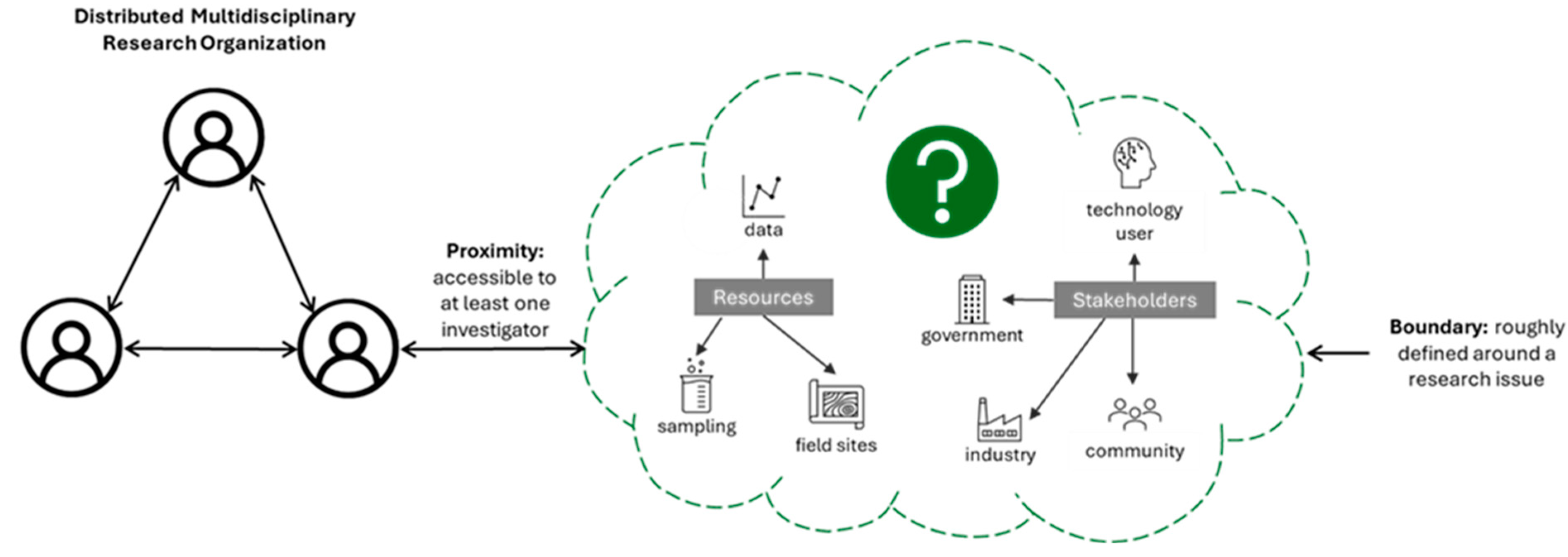
Identifying a potential TBL Site location should be guided by the four criteria, as illustrated in
Figure 1. A reasonable proximity to researchers is needed to ensure access to resources and stakeholders, although this need not be interpreted strictly in terms of distance. For example, the agricultural TBL Site is located at a research station separate from its proximity institution.
However, faculty involved in the STEPS Center regularly conduct research at the station, providing access to resources and data. Defining a site boundary is also flexible and will depend on the research focus. As noted, the STEPS Center chose its initial sites based on known phosphorus flows and defined their ecosystem affiliation by the source and transport of phosphorus within these systems. Researchers focused on safe and sustainable access to food might define different types of ecosystems, for example, as inner city, suburban, and rural. A network of diverse stakeholders is also important for sustainability research. Access to a broad network will ensure (1) the perspectives of individuals and communities who are affected by an issue or may be impacted by change are understood and addressed, and (2) that the needs and perspectives of those who will use, fund, or regulate outcomes generated by the research are also included.
Thus, these diverse concerns could be addressed by conducting the research in a single location, where researchers can make observations on all three dimensions of sustainability. We therefore define TBL Sites as geographic locations representing distinct ecosystems, with resources and stakeholder networks relevant to sustainability research and goals. The TBL Sites serve as unique physical systems, each encompassing a real place with many interrelated attributes that provide context to a specific sustainability research focus (e.g., the phosphorus cycle).
Table 1 describes the four criteria for each of the STEPS Center’s TBL Sites. As described below, these sites are quantifiable, analyzable, comparable, and serve as platforms for research and its local or global dissemination.
2.2. Multiple TBL Sites for Comparative Case Study
An organization may also choose to designate multiple TBL Sites to compare intervention scenarios and outcomes, introducing the need for a list of factors common across, but distinct between, TBL Sites. As with the four criteria for site selection, the choice of factors will depend on the research goals of an organization.
For the STEPS Center, a framework devised by Metson et al. [
25] provides guidance for research to address gaps related to the triple bottom line factors in urban phosphorus flows, with consideration of both the natural and built environment in a given location. Biogeophysical factors include climate, precipitation, and soil type, while attention to the built environment focuses on sewage, roads, and energy generation. Economic research attends to relevant markets and the ready availability of capital to support interventions. Social research addresses a range of questions, including the government agencies that regulate environmental issues, as well as other arrangements for phosphorus management originating with stakeholders. Social research may also address cultural norms and preferences that shape behaviors affecting phosphorus management and that guide a community’s priorities for the future. This research agenda is expansive, demanding participation across a breadth of disciplines and community members. In
Table 2, we have adapted the framework developed by Metson et al. [
25] to account for phosphorus research beyond the urban systems they addressed. This framework identifies eleven different dimensions where we expect similarities and differences among our existing TBL Site systems, scales, and scope. Identifying these criteria during TBL Site selection supports future research agendas through the connections and collective experiences TBL Sites provide. For example, an investigator might use the maximizing differences method described by Seawright and Gerring [
26] for case studies to begin to draw inferences about the role of surface water systems and phosphorus flows relative to the biogeography of each location, where two are in subtropical climates with high rainfall and the third is in a desert climate with low rainfall. It should again be noted that an organization with a different sustainability focus might want to compare different factors or subfactors, such as biodiversity or ecosystems services under
Environment.
In summary, the protocol to identify a TBL Site is an iterative process based on an organization’s research needs related to environmental, social, and economic innovations in sustainability. These needs may range from a particular focus, such as sustainable phosphorus management, to broader targets—for example, one or more of the United Nations’ Sustainable Development Goals [
27]. Four criteria provided as guidelines for designating a TBL Site are that a site has to (1) be in a location that is proximate to researchers (i.e., closely located to allow for study), (2) encompass an issue or system of interest but still be manageable within the context and constraints associated with environmental or other research objectives and outputs, (3) represent stakeholder narratives that correspond to elements (e.g., policy, population density, cultural diversity) of the social aspect of sustainability, and (4) provide resources such as historical information, data sets, sampling locations, or other supportive organizations. The site should also provide enough scale and scope to examine the direct and indirect economic impacts of implementing new technologies and best management practices within a local region. Addressing the people, planet, and prosperity aspects of a potential TBL Site provides a testbed for developing and analyzing intervention scenarios. These scenarios may involve the modeling, implementation, or integration of changes to the system such as introducing novel technologies, best management practices, new policies, or behaviors. Creating a list of factors relevant to a research agenda that can be applied to multiple TBL Sites also provides the opportunity to compare and contrast intervention scenarios. Multiple distinct TBL Sites then provide a platform to support the generalizability of observations, compare analyses using information generated at other TBL Sites, or test new models or technology across systems.
3. Results and Discussion
Three distinct ecosystem TBL Sites are described in detail below with examples of how these sites are being used as boundary objects to support convergence and sustainability outcomes and the transdisciplinary research conducted therein. Each site contains demonstrable phosphorus flows, stakeholder networks, information archives, and other resources, and is proximate to a STEPS Center affiliated institution or location to facilitate research and evaluation. We discuss how current or potential future work being conducted by STEPS Center researchers engages with the TBL Sites in terms of environmental, economic, and social factors toward the goal of sustainable phosphorus management. We also consider how similarities or differences between the TBL Sites are, or could be, leveraged for cross-site data collection and modeling. This discussion demonstrates the benefit of developing TBL Sites as boundary objects to support convergence research through integrated knowledge sharing, co-creation, and implementation across diverse perspectives, and to tackle a specific sustainability issue across multiple geographic locations with the potential to generalize to broader scales.
Figure 2 illustrates the location of the three initial STEPS Center TBL Sites. The sites are not intended to be representative of all possible ecosystems, though the similarities and differences between them provide opportunities for meaningful comparisons. The sites were selected based on known phosphorus flows and issues, existing research and resources in these areas, and an established stakeholder network, as described in
Table 1. These sites were broadly characterized as urban (Phoenix metropolitan area), agricultural (Tidewater Research Station in North Carolina), and aquatic (the Florida Everglades watershed). At each site, researchers had pre-existing relationships with networks of stakeholders through previous work, regional organizations (e.g., NC Cooperative Extension Services, South Florida Water Management District), and relevant stakeholders from agriculture, industry, government agencies, non-governmental organizations, and public utilities. Those networks embodied contextual expertise on phosphorus management to help guide research questions and align interests for the development and adoption of efficient, safe, and economical means of addressing phosphorus sustainability. Within each of the locations are resources from field sites to complementary research projects that could be leveraged or expanded upon to include phosphorus sustainability research goals.
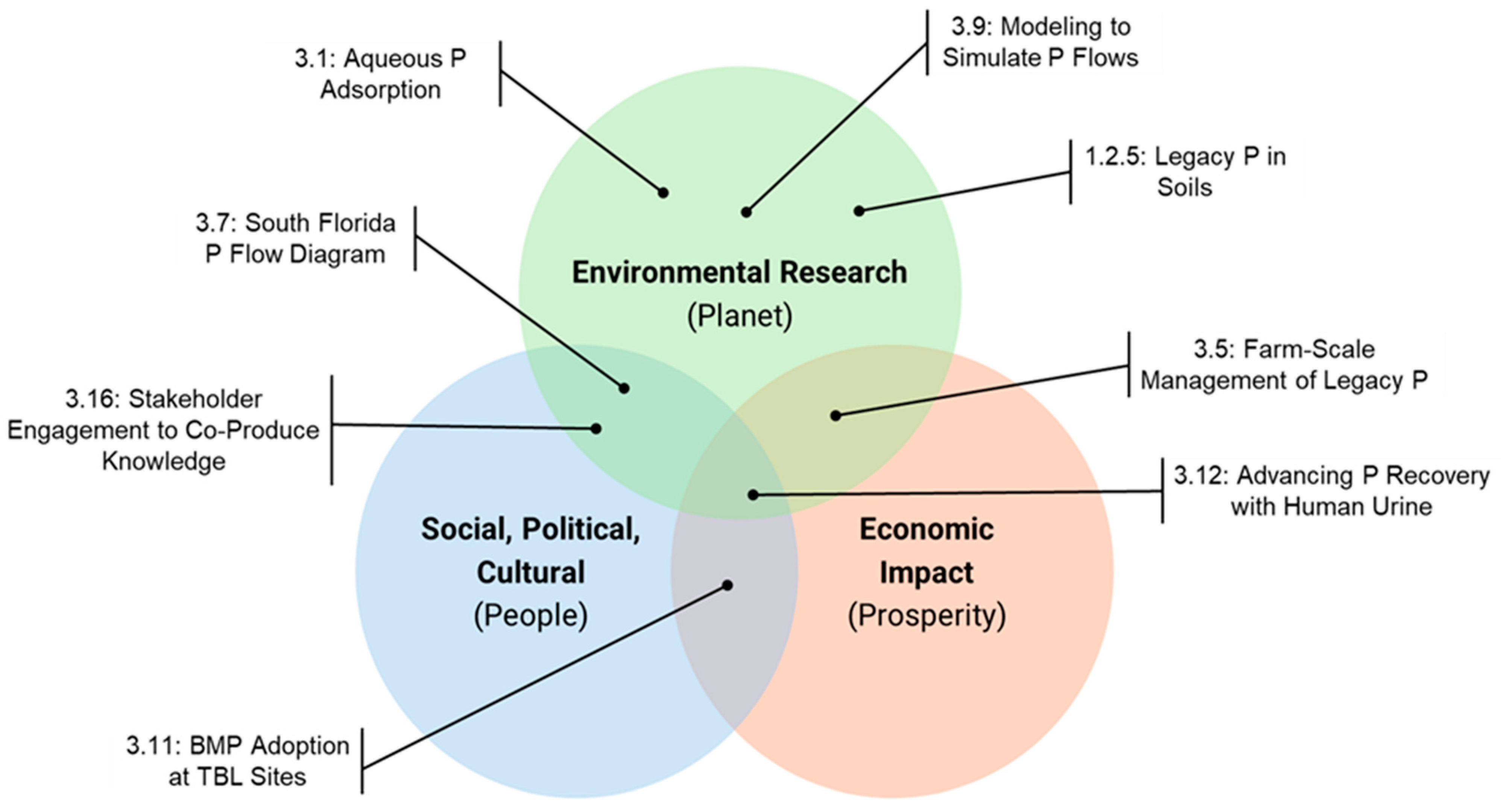
The research agenda that occurs at these TBL Sites aims to reflect a full triple bottom line approach. The classic Venn diagram illustrated in
Figure 3 includes seven unique forms of research (people, planet, profit, people/planet, people/profit, planet/profit, and all three together). As a starting point, the STEPS Center sought out proposals for research in these TBL Sites that aligned with the STEPS Center’s goals for phosphorus sustainability.
Figure 3 highlights where those proposals estimated their impact on the three bottom lines would occur. As we solicit and evaluate new project proposals at the TBL Sites, we consider ensuring broad representation across these seven components of the Venn diagram.
3.1. Aquatic TBL Site
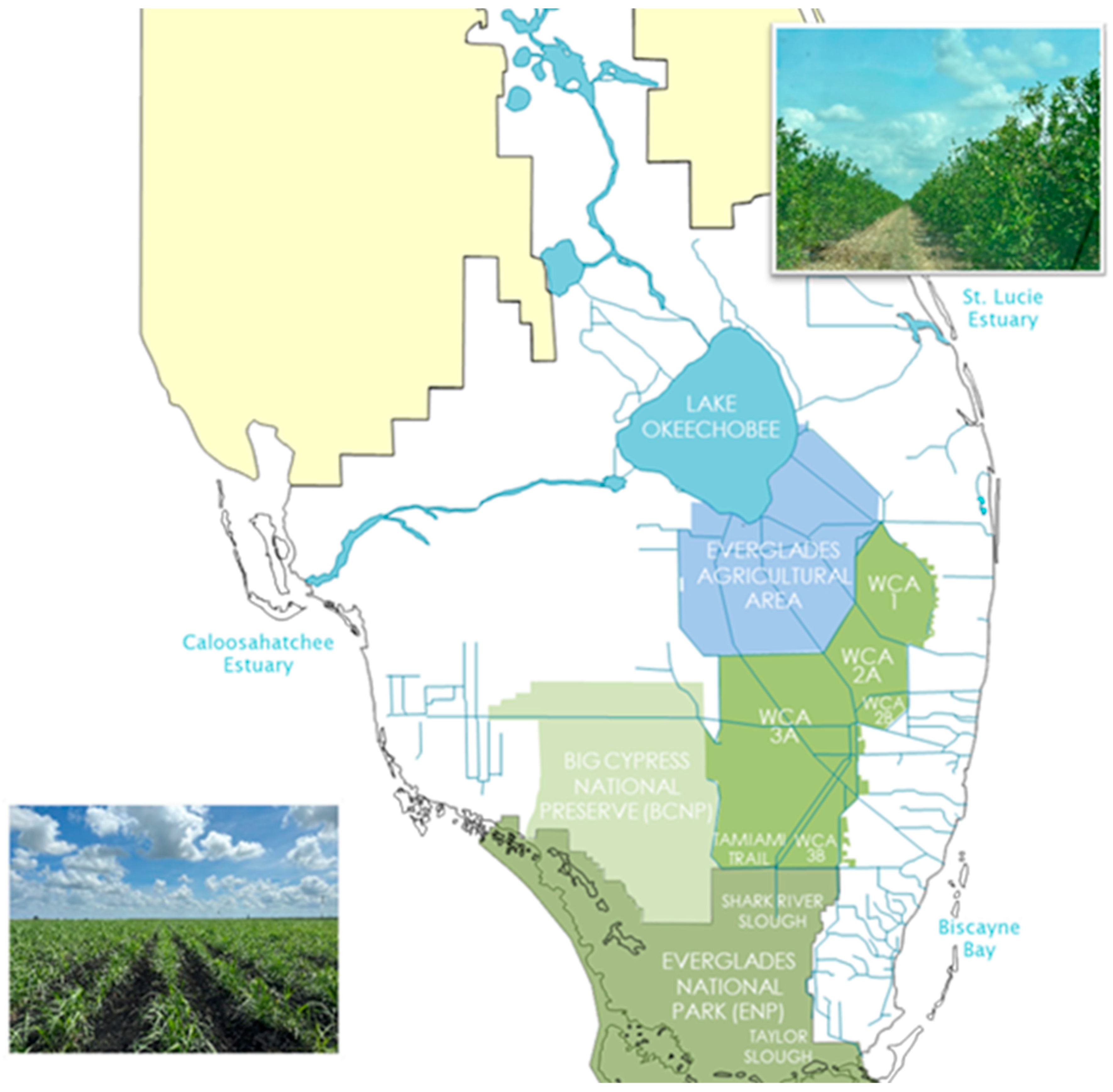
The aquatic TBL Site shown in
Figure 4 is in central and south Florida, encompassing over 12,000 km
2 of interconnected natural and constructed aquatic ecosystems surrounding Lake Okeechobee (Lake O). South of Lake O are the Everglades Agricultural Area (EAA), Stormwater Treatment Areas (STAs), Water Conservation Areas, and the Everglades National Park. Also included are the Caloosahatchee River and Estuary to the west of Lake O, and the St. Lucie Estuary to the east. The high annual rainfall and flat topography of Florida make the management of hydrologic and nutrient flows between the regions critical to the surface water quality of this aquatic ecosystem. Agricultural production within the drainage basin consists of cattle north of Lake O, citrus orchards to the east, and fields of sugarcane, rice, vegetables, and sod to the south [
28]. Development along either coast supports a high population density and an active tourism industry. There is a complex and extensive stakeholder network within this region, comprising residents, recreational users, Indigenous communities, farmers, industry, water management districts, and the U.S. Army Corp of Engineers. Because phosphorus has been an ongoing issue related to water quality across the entire area [
29], numerous resources related to phosphorus management exist such as hydrologic data, regulatory infrastructure for phosphorus management, environmental consulting firms, and resources from the University of Florida (STEPS Center member institution) along with satellite research and education stations strategically situated within the different regions. Although each region surrounding Lake O embodies different complex ecosystems, collectively, they provide extensive monitoring of hydrologic flows and water quality that can be related to phosphorus speciation and turnover within the aquatic TBL Site waters, sediments, and soils. Due to the complexity of the lake and its watershed, the boundaries of the aquatic TBL Site are currently being refined by co-producing a map with key stakeholders in the region.
The history of the aquatic TBL Site includes many phosphorus-related issues [
29], providing substantial opportunities to study phosphorus flows and test potential interventions. Native and legacy phosphorus in soils, combined with high nutrient inputs from both agriculture and urban sources (including through wastewater treatment and septic systems), have led to significant environmental impacts and water quality impairment. This impairment includes eutrophication and harmful algal blooms (HABs), although HABs also involve other drivers in addition to phosphorus [
30].
In 1994, the Florida legislature recognized the impacts of phosphorus to the ecosystem through the Everglades Forever Act, which tasked the South Florida Water Management District (SFWMD) with developing nutrient management strategies that include most of the area located within the aquatic TBL Site [
31,
32,
33]. As a result of this legislation and the flexibility in its implementation, over the past two decades, water quality has improved and phosphorus flows out of Lake O and the EAA are better controlled [
34]. The SFWMD continues to support the study of soil and water phosphorus flows, improved monitoring strategies and technologies, and working with stakeholders to advance best management practices. Satellite research centers located within the TBL Site boundaries help foster convergence research by concentrating many disciplines in one location, so that scientists and Cooperative Extension agents can easily access expertise outside of their own field of study. In this way, the TBL Site serves as a boundary object to facilitate the co-creation of knowledge and ideas. Following are several examples of how the STEPS Center’s convergence work in the aquatic TBL Site brings multiple perspectives together across academic disciplines and industry sectors that would otherwise tend to function in isolation from each other.
A multidisciplinary approach is particularly important when research objectives have the potential to yield conflicting outcomes. For example, in the case of citrus trees affected by Huanglongbing (HLB), also known as citrus greening disease, research supporting the continued or increasing application of phosphorus [
35] may run counter to environmental mitigation strategies and nutrient management plans that advocate for reduced phosphorus usage. In the aquatic TBL Site, a STEPS Center project is seeking methods for making legacy phosphorus more available to plants. This research complements both agronomic and environmental goals by supporting commercial grower needs while leveraging legacy phosphorus in soils to reduce additional fertilizer application.
In the aquatic TBL Site, soils and water are inextricably connected. Although the Everglades Forever Act has had an impact, additional best management practices are needed to limit phosphorus inputs from both agriculture and urbanization. As noted above, a key challenge is balancing fertilizer use to increase agricultural production as an economic driver, the societal demand for a clean water supply and adequate food supply, and the environmental goal of reducing phosphorus concentrations entering the ecologically sensitive surface waters of the Everglades. STEPS Center researchers have begun addressing this challenge through projects that promote convergence research and stakeholder engagement to develop sustainable phosphorus management strategies. For example, a multidisciplinary team is working in collaboration with commercial citrus farmers to identify methods to make phosphorus management more efficient using smart and precision irrigation techniques. By utilizing real-time data collected through automated irrigation systems and in-field sensors deployed on farms within the TBL Site, the project aims to increase phosphorus use efficiency. Researchers want to integrate multiple monitoring services into existing technology platforms to encourage farmers to adopt these automated systems (see Stroobosscher et al. [
36]).
Changing land use from agriculture to water storage strategies such as dispersed water management systems (SFWMD, n.d.) is another example of a convergence research approach within the aquatic TBL Site. Fallow citrus orchards influenced by the citrus greening disease are converted to water storage systems that capture regional runoff during the rainy season or storm events. Detaining these flows supports both hydrologic and nutrient management by capturing and holding phosphorus in the bottom of these adapted lands. This strategy provides an economic benefit to farmers by replacing lost agricultural income, while the water storage systems in turn create an environmental service by reducing phosphorus contamination to estuaries and the Everglades [
37]. Although studies have shown how phosphorus is stored in these constructed wetlands, future projects for the STEPS Center and other researchers may help assess long-term environmental benefits as well as the impacts of upstream management practices [
38]. Additional research could identify whether phytoremediation or plant uptake of phosphorus can improve the water quality of these storage areas, providing another approach to support the demand for clean drinking water by a growing urban population.
Convergence research can also be demonstrated within the aquatic TBL Site through a multidisciplinary approach that integrates phosphorus management with other sustainability initiatives such as carbon sequestration and carbon credit programs. In the EAA south of Lake O, subsidence (soil loss) is a critical concern. The Histosol soils in this region contain over 80% organic matter [
39]. When the original swamps and flooded prairies were drained for development, the soils became aerated, and the organic matter began to decompose. There has been nearly 2 m (6.5 feet) of subsidence over the past century, equivalent to 5 × 10
8 metric tons of carbon dioxide emissions [
40]. Additionally, as the soils become shallower, more of the underlying limestone bedrock is exposed, raising the soil pH and binding the phosphorus with calcium. Soil legacy phosphorus then increases as this binding prevents plant uptake, requiring increasing amounts of fertilizer application to support agricultural yields. Mitigating these complex challenges requires integrating multiple lines of research such that the outcomes build soil carbon through the addition of new organic matter while also converting the bound phosphorus to available forms that reduce the need for additional fertilizer application.
Finally, the aquatic TBL Site acts as a boundary object for convergence by fostering education, broadening participation, and providing knowledge-sharing opportunities. For example, graduate students working on research projects within the TBL Site boundaries engage with different aspects of the many issues noted above while also developing an understanding of how their research will impact the ecosystem and its stakeholders. Students also learn how to communicate with stakeholders to inform their own research objectives and to disseminate results (see, for example, this student-led report [
41]). Farmers and other community members are realizing the economic benefits of utilizing Cooperative Extension services to access information and management practices that help them reduce their fertilizer input costs. These same stakeholders are also guiding research by engaging in dialog with the STEPS Center team members on specific issues and providing feedback on preliminary research outcomes that are relevant to them.
3.2. Urban TBL Site
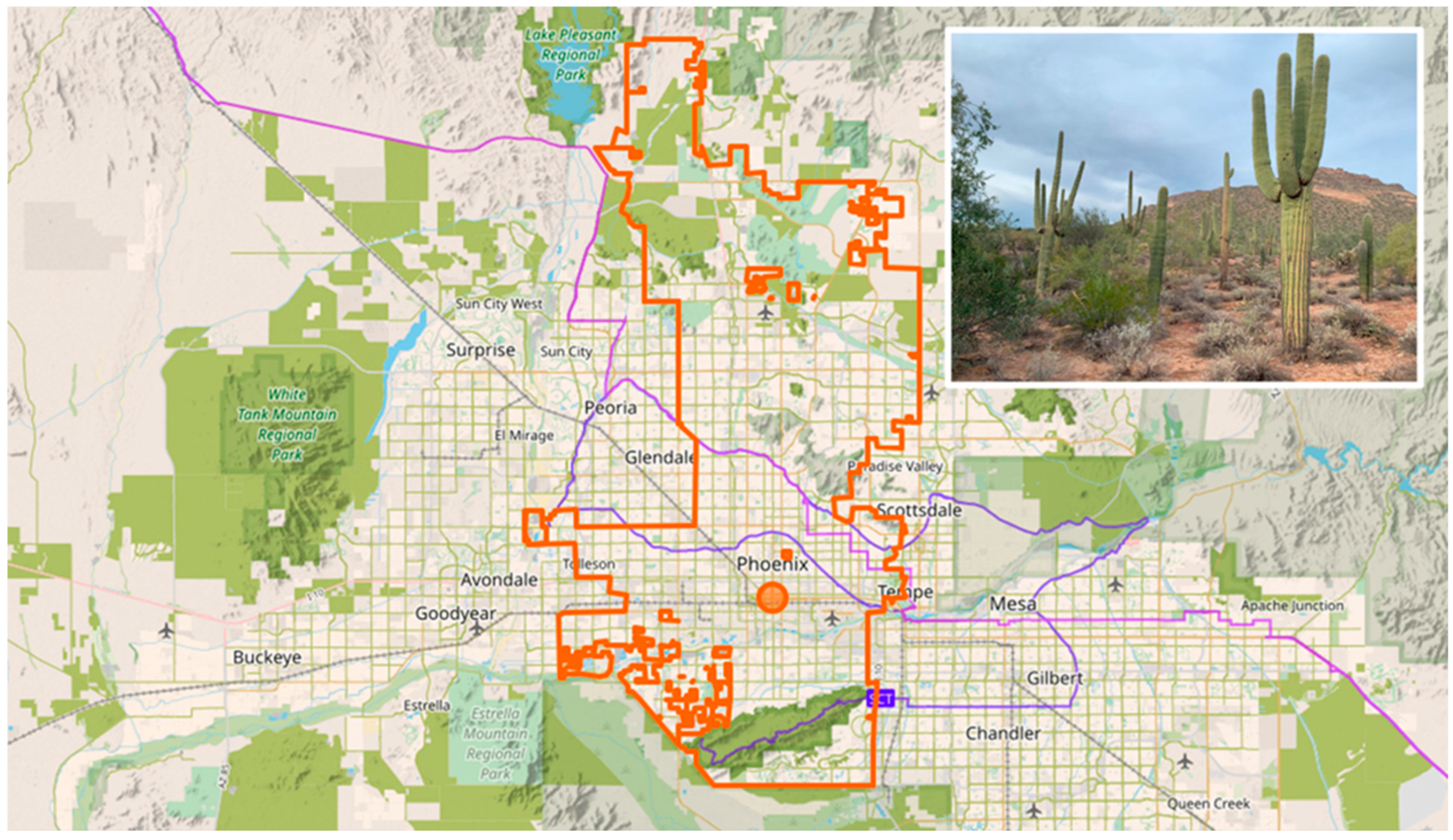
The urban TBL Site—outlined as the greater Phoenix metropolitan area in
Figure 5—is identified and bounded by the 6400 km
2 footprint of desert, agricultural, suburban, and urban land in the Central Arizona-Phoenix Long-Term Ecological Research (CAP-LTER) project [
42]. CAP-LTER is part of the National Science Foundation’s Long-Term Ecological Research (LTER) Network of research sites and was developed to integrate multiple disciplines and cultivate long-term relationships with local communities to understand how a rapidly growing city impacts its natural environment [
43]. Established in 1997, the CAP-LTER research program provides opportunities to examine phosphorus imports and flows. Although nitrogen is considered the limiting nutrient in the study area and tends to dominate the research focus, there are several long-term studies that include phosphorus-related data, from water quality and urban stormwater monitoring to ecological surveys, atmospheric deposition, and a desert fertilization experiment [
44,
45,
46].
The urban TBL Site focuses on urban ecology and socioecological systems related to the Phoenix metropolitan area and the surrounding Sonoran Desert [
47]. The geography and climate of CAP-LTER make it unique as a TBL Site with regard to phosphorus sources and transport, as it is very different and more intimately connected to human infrastructure but less dependent on natural hydrology than either the aquatic or agricultural TBL Sites [
25]. Arizona State University’s Tempe campus (STEPS Center member institution) is nestled within the urban TBL Site boundaries, and STEPS Center researchers engage in multiple sustainability-related research projects in the area. In contrast to the other STEPS Center TBL Sites, the urban TBL Site provides a particularly unique situation regarding hydrology that is dominated by engineered urban aboveground and buried drainage systems, an arid climate, and a basin-like geography. These characteristics make this TBL Site a naturally bounded system with little surface water inflows or outflows, while water use allocation is a key policy issue in the area. Water recycling strategies can also support phosphorus recycling, such as the use of nutrient-rich wastewater to irrigate agricultural fields [
42]. Summer monsoon season can drive nutrient flows through sediment transport and runoff, but the source has shifted from agriculture to urban stormwater as legacy farmland is converted to suburbs in support of a growing population.
In 2012, a spatial and temporal phosphorus budget was published by Metson et al. [
42,
48], quantifying phosphorus fluxes and identifying key factors that drive phosphorus flow dynamics in urban systems. The framework of social, ecological, and economic factors the authors developed helped them understand how phosphorus affects an urban ecosystem. Thus, the urban TBL Site acts as a boundary object linking multiple perspectives across seemingly unrelated sectors to phosphorus use and management. Those factors are adapted in
Table 2 and expanded so that they apply to all of the STEPS Center TBL Sites. Examining these factors across different locations can support STEPS Center researchers and stakeholders to develop a more holistic view of how human behaviors influence phosphorus in the landscape. Furthermore, new STEPS Center research is being proposed to update the urban phosphorus budget and correlate the rapid population growth in Phoenix over the past decade to changes in phosphorus inputs, storage, and outputs.
Food import and production are the main sources of phosphorus flows into and within the region, where they are subject to various processes of cycling through waste treatment (e.g., aeration, anaerobic digestion, sewage solids land application) and storage (e.g., landfills, legacy phosphorus fertilizers in soils). The built environment (roads, buildings) also represents a major storage sink, with slow turnover of phosphorus in the TBL Site. The urban TBL Site provides important context for STEPS Center researchers who are working to improve these cycling processes to conserve and recover phosphorus from waste streams. For example, STEPS Center researchers are improving urine diversion technologies by identifying buildings with high potential for resource recovery from collected urine [
49] and implementing treatment processes that prevent phosphorus losses within pipes and recover phosphorus [
50]. This context supports technology adoption by providing researchers access to critical stakeholders (e.g., facilities staff, end users), applications (e.g., commercial, institutional), and potential constraints (e.g., building codes, user preferences).
Landfills represent a major sink for phosphorus in this urban TBL Site. Equally important, but having greater input/output fluxes, all the phosphorus from sewage solids or dairy manure are land applied within, or near, the CAP-LTER boundary; usually, these are applied to non-human consumptive croplands but are increasingly being marketed for turf or home garden applications. Industrial use of phosphorus (e.g., phosphoric acid in food products, phosphine gas in semiconductor manufacturing) represents a largely under-studied research area.
Ongoing sustainability initiatives within the CAP-LTER program could also be leveraged by STEPS Center researchers through the urban TBL Site to investigate other strategies and technologies for sustainable phosphorus management. For example, a transdisciplinary team might explore economic incentives for developing technologies that can “mine” phosphorus from food waste and wastewater treatment residuals. A convergence research strategy could be adopted to help develop alternative protein sources to supplement or even supplant animal agriculture in urban settings. Researchers could also support sustainable urban growth using geospatial data analytics and social science to incorporate phosphorus management within a Geodesign planning approach to land use that engages marginalized communities for water availability and livable urban habitats [
51].
3.3. Agricultural TBL Site
The agricultural TBL Site is defined by the Tidewater Research Station highlighted in
Figure 6, located in the coastal plains of North Carolina which are known for highly productive organic soils. Tidewater serves as an Experimental Research Station shared between the North Carolina Department of Agriculture and Consumers Services and North Carolina State University (STEPS Center member institution). The location features a flat topography, shallow water table, and dynamic coastal weather, which are features similar to the aquatic TBL Site in Florida and require extensive surface drainage management for both irrigation and flood control. Among the three STEPS Center TBL Sites, the agricultural TBL Site has the smallest and most well-defined footprint, encompassing slightly over 6 km
2 of woodland, cropland, pastures, ponds, and other surface features. The station’s mission is to “…serve as a platform for agriculture research to make farming more efficient, productive, and profitable, while maintaining a sound environment and providing consumers with safe and affordable products” [
52,
53]. This mission aligns with the triple bottom line factors for environmental, economic, and social sustainability, and includes research projects studying crops, soil, water, livestock production, and aquaculture. There are strong ties between the research station and local stakeholders through organizations such as the Cooperative Extension Service and a local farming coalition known as the Blackland Farm Managers Association [
54,
55]. Additionally, ongoing long-term fertilizer trials initiated in 1966 provide historical data specifically related to phosphorus use and management practices.
The breadth of research at the Tidewater Research Station within the agricultural TBL Site sets the stage for potential collaboration and convergence within the STEPS Center team, across research projects, and with local community stakeholders. The ecological diversity, seasonal fluctuations, and the different types of land use practices contribute to a complex system of phosphorus management and flow within the TBL Site boundary. Phosphorus accumulates in soils over time. The longevity of these studies supports research opportunities for the STEPS Center, particularly with respect to phosphorus deficiency, legacy phosphorus, and phosphorus loss from agricultural soils. For example, data from the trial were used to revise phosphorus application recommendations for North Carolina crops based on evidence that, in soils with high phosphorus sufficiency, there would be no yield response with additional applications [
56].
Other STEPS Center research projects conducted at the agricultural TBL Site include modeling legacy phosphorus and phosphorus flows through water and soil sample analysis and improving phosphorus uptake efficiency and fertilizer management in corn. Future work could further integrate phosphorus research into other projects by leveraging additional ongoing trials at this location. For example, one upcoming study on crop rotations will measure soil carbon for greenhouse gas emissions. Quantifying soil phosphorus along with carbon and nitrogen during sampling events may yield novel insights into how microbial activity impacts the release of carbon dioxide and other greenhouse gases. Such studies also provide real-world applications for testing new technologies and methods to differentiate and measure phosphorus species. The agricultural TBL Site can also be used to perform field experiments to test the efficacy of new fertilizer technologies developed by the STEPS Center team as phosphorus enhancers that unlock the potential of soil phosphorus.
The application of phosphorus research to real-world problem-solving at the agricultural TBL Site also gives students and those working in laboratory settings the opportunity to envision their work in the broader context of agricultural sustainability. The annual STEPS Center Research Experience for Undergraduate program conducts a field trip to the agricultural TBL Site during its orientation week to give budding researchers an immersive field experience. Additionally, because the agricultural TBL Site is in one of the most important agricultural regions in North Carolina, STEPS Center researchers are able to work with local farmers and producers to disseminate knowledge through field days or develop complementary on-farm research experiments. This stakeholder engagement is a critical function of the TBL Site as a boundary object for convergence, allowing the exchange of ideas and knowledge to build common understanding among multiple sectors and disciplinary perspectives. In summary, the STEPS Center agricultural TBL Site provides the location and services needed to conduct research, deploy and observe interventions, and disseminate outcomes to a broader audience.
3.4. Cross-Site Connections
The STEPS Center utilized all three TBL Sites collectively to better understand the similarities and differences in phosphorus flow and management within these ecosystems. The social, economic, and environmental factors listed in
Table 2 can affect phosphorus use at any of the three TBL Sites. For example, the integration of agricultural, hydrological, environmental, and economic factors in the agricultural TBL Site mimics the aquatic TBL Site but in a much more compact setting, while the same factors differ substantially in the urban TBL Site. By identifying which factors are most influential at each TBL Site, STEPS Center researchers are able to test hypotheses related to phosphorus management, technologies, and interventions. At the urban TBL Site, full-scale urine diversion systems collect and precipitate phosphorus from human urine, recovering phosphorus that would otherwise be lost in municipal wastewater systems. Deploying this technology across the other TBL Sites may improve adoption outcomes and generate broader stakeholder dissemination and feedback related to multiple factors from social acceptance to regulatory and infrastructure issues.
Another example is the ability to share data from sampling events between multiple projects across the TBL Sites. Water and soil sampling conducted at all sites can be used to help determine whether isotopic “fingerprints” for phosphorus sources developed at one site are broadly generalizable across the other sites. This STEPS Center project couples eco-hydrodynamic models with stable isotopes to look at phosphorus transport in the environment and determine whether both approaches give similar results as well as evaluate the limitations of each method. Although the project began with the agricultural TBL Site because its systems are more constrained and manageable, the research has expanded to look for similar patterns at the other TBL Sites. Furthermore, the sampling and testing protocols developed at the agricultural TBL Site were then used at the urban TBL Site.
The ability to integrate stakeholder perspectives within and across different ecosystems is another advantage of using TBL Sites as boundary objects for convergence research. A project to further define the aquatic TBL Site ecosystem boundaries began by engaging key stakeholders (e.g., management agencies) to co-create a map and define priority areas of concern as well as management targets. Because the aquatic TBL Site has such an extensive geographic footprint, refining of the aquatic TBL Site can help identify where within its boundaries to showcase technologies while also developing critical relationships with different potential collaborators (stakeholders). Access to a network of collaborators is another advantage of the TBL Sites because establishing these relationships requires significant time and resources. Thus, future research will benefit from an established collaborative stakeholder network.
The unique ecosystems across the TBL Sites allow researchers to better understand locations with which they may be unfamiliar. The ability to gain foundational knowledge about different ecosystem types and contexts is particularly useful when mapping the TBL Sites and their systems to global or regional phosphorus mass flow diagrams. Flow diagrams are another STEPS Center boundary object used as a common reference point. Researchers can learn about the differences between TBL Site characteristics such as soil types, geography, land use, seasonality, and weather events and timing (e.g., hurricane season on the East Coast is different from the monsoon season in Arizona). For example, a project evaluating legacy phosphorus identified and characterized different phosphorus forms and pools across all three TBL Sites, noting that the aquatic, agricultural, and urban ecosystems represent microcosms of global phosphorus flows. This mapping process could identify levers to change phosphorus mass flows in any area of a phosphorus flow diagram and could use developed phosphorus sustainability technologies to predict downstream effects.
3.5. TBL Sites as Boundary Objects
The TBL Sites serve as boundary objects for convergence research in sustainability by providing a real-world platform for diverse disciplines to engage with—through research and education—the environmental, social, and economic aspects of a topic of interest, such as phosphorus flows and management. Researchers across all scales, from nanotechnology to field studies to modeling regional economic and policy processes, can identify with aspects of TBL Sites or projects situated within them. Thus, the TBL Sites unite the social worlds of chemists, biologists, material scientists, agricultural and environmental engineers, economists, sociologists, and many other disciplines. The sites provide structure for these researchers (e.g., soils and bodies of water to sample, fields for growing crops, stakeholder networks that can be queried about different practices), even as they retain the flexibility to accommodate all these different priorities. While the researchers are free to pursue their own disciplinary objectives, they depend on each other’s insights. Scientists and engineers developing sustainable technologies and practices are concerned about whether these innovations will be useful to end users, while social scientists need to understand how those new technologies work to make an accurate assessment of adoption and impacts. Thus, the TBL Sites give rise to an operational dynamic that encourages close collaboration among experts from many different disciplines and scales.
For the STEPS Center, the TBL Sites have also become crucial locations for making broader impacts beyond its own research discoveries. First, they provide ample educational opportunities for both undergraduate and graduate students to understand how their disciplinary studies relate to real-world applications. Field soil and water testing provide experiential learning about the importance of good practices such as preserving samples and taking accurate measurements. For many students, “soil” and “water” become abstractions in a textbook or laboratory setting; by putting on a pair of boots and wading into the water, a student gets to experience a different perspective of the world than is available in traditional educational settings.
In addition, the scientists and engineers who work predominantly at the TBL Sites are already embedded in extensive stakeholder networks. They are so familiar with end users’ needs and concerns that they can offer new directions for research to support the adoption and diffusion of innovation [
57]. By virtue of the work these researchers do, they are not just familiar with well-organized and powerful stakeholders but also with stakeholders who come from marginalized communities, thus creating the possibility of broadening participation in knowledge transfer and research. This inclusivity also encourages integration of other sustainability initiatives in social, economic, and environmental fields. By allowing researchers to structure and share their research and teaching around multiple disciplines, the TBL Sites are boundary objects that foster collaborative solutions, such as for phosphorus sustainability. Thus, the TBL Site also embodies the concept of a “Transdisciplinary Boundary Layer” Site that supports convergent and sustainable outcomes.
3.6. Scales
As previously mentioned, STEPS Center research projects occur at and across different levels of the physical scales, from the materials level up through the human–technology level, to the regional–global level. However, these physical levels are only one scale by which we can measure various research activities.
Cash et al. ([
58], p. 3) identify seven different scales at which human–environment interactions can occur: spatial (closest to the physical scale mentioned above), temporal, jurisdictional, institutional, management, networks, and knowledge scale. Each of these scales is composed of multiple levels. For example, the temporal scale goes from the most continuous data collection or phenomena at the lowest level (e.g., a constantly monitoring sensor in surface water) up to rates, durations, or frequencies for data collection or phenomena that occur very infrequently at the highest level (e.g., a decennial Census).
Materials-level research may be well suited by only focusing on the spatial/physical scale or a specific subset of Cash et al.’s scales, but human–technology-level and regional–global-level efforts can be categorized across many of these scales. A stormwater modeler will likely need both data about the regional watershed (spatial) and the entities that have policy-making authority (jurisdictional) to ensure outcomes can be appropriately forecasted. Modeling how a farmer makes decisions about fertilizer application might involve a combination of localized networks of information and contextual knowledge about their specific plot of land.
It should be noted that the scales of the TBL Sites in which research is conducted, and the different aims within the TBL Venn diagram in
Figure 3, do not necessarily correlate to the scales at which this research occurs. For example, an economic research question can use a narrow, specific unit of analysis like a transaction or a much wider, broader unit of analysis like the market for a product. Therefore, while some academic disciplines may already consider multiple scales, other fields that operate in narrow windows may realize broader scales by which their research can be interpreted through the convergence fostered by TBL Sites.
3.7. Limitations and Challenges
TBL Sites can be used as comparative case studies by comparing and contrasting factors across different sites with research outcomes. Such comparative case studies are frequently used in social science inference when there are a limited number of observations of complex phenomena, but they do have substantial limitations. The few cases available present significant challenges to generalizability, as these social phenomena are often unable to be reproduced en masse nor do they lend themselves to the manipulated control variables that lab sciences offer. Within complex phenomena, the observations are often interdependent and “… having many implications is not the same thing as many observations” ([
59], p. 87). Another concern is equifinality or multiple causation, when two or more entirely different concoctions of factors can yield the same results ([
60], p. 87). Ignoring equifinality can lead to researcher bias that underspecifies the conditions under which complex phenomena can occur.
The TBL Sites examples presented herein are complex phenomena from both social and natural sciences perspectives. The factors listed in
Table 2 by which the TBL Sites are compared do not exist in isolation from one another. Each region has history and path dependence that both influence the evolution of and shape the future potential outcomes of these factors concomitantly. However, despite the fact that the TBL Sites are more complex than the simple sum of their parts, individual projects may isolate these factors for study, and comparing across these factors can point us toward what yields different outcomes.
Thus, both an advantage and a limitation of a TBL Site is its distinctiveness. While one should remain cautious not to overstate the conclusions that can be drawn from comparative case studies, there is value to making inferences as clues for further investigation. When these findings hold up to replication studies or can be demonstrated to be consistent with new comparable cases, the mechanisms identified gain validity, despite the low sample size and potential for equifinality.
3.8. Future TBL Sites
As previously noted, the three TBL Sites discussed herein do not exhaust all the possible phosphorus sustainability issues that arise across ecosystems. To address other possible systems, the STEPS Center is considering additional TBL Sites to complement its research portfolio and diversify its agricultural settings. For example, two potential sites under consideration are the High Country of North Carolina and sites in the upper Midwestern USA. The potential High Country TBL Site would share similarities in state governance characteristics with the Tidewater region of the current agricultural TBL Site (also in North Carolina); however, the geophysical settings are markedly different. Where the Tidewater region is dominated by row crops and commercial swine operations, the High Country region has more small landholder farms growing evergreen trees and raising cattle. In the upper Midwest, the dominant forms of agriculture are row crops, specifically corn and soybeans, as well as pork production, similar to the agricultural TBL Site in North Carolina but at a much larger scale. In addition, Midwestern states have very different approaches to regulating the environmental impact of agricultural production compared to North Carolina and Florida.
Thus, it is important in choosing additional sites to consider other criteria of “distinctiveness”. Beyond the logistical questions of resources and expertise, an organization should evaluate where these potential sites are alike and divergent from the existing TBL Sites by providing comparisons, creating a more complete spectrum of variation, introducing new types of variation, or suggesting new combinations of factors that yield similar outcomes [
26].
The TBL Site framework could also support integration of academic disciplines in context-specific research programs with applicability for other complex problems beyond sustainability issues. One example far afield from sustainability that could import this method would be opioid addiction response. Three geographic sites could have different characteristics (e.g., high illicit supply, high illicit demand, and overprescription) that influence the research. Multiple disciplines could be integrated to address the concern, with factors related to social work, criminal justice, public health, and pharmacology. These research projects could be plotted across what addresses the issue directly, what is economically feasible, and what is socially desirable in these context-specific sites. As a result, a more complete picture of a complex issue like opioid addiction may be amenable to this TBL Site framework with problem-specific modifications.
4. Conclusions and Future Work
Today’s “wicked problems” require tools that support and accelerate transdisciplinary research across multiple perspectives and geographies. We have provided a framework for developing a tool—the TBL Site—to streamline the convergence research process. TBL Sites serve as boundary objects to advance convergence research by providing focal points for developing shared language, disciplinary understanding, resources, and networks across diverse research perspectives using a real-world setting. They are unique physical systems, each encompassing a real location with many interrelated attributes that provide context to a specific sustainability research focus (e.g., the phosphorus cycle). TBL Sites also act as designated testbeds for evaluating innovations, knowledge exchange, and measuring sustainability outcomes across environmental, social, and economic factors. Thus, we define TBL Sites as accessible geographic locations representing distinct ecosystems, with resources and stakeholder networks relevant to sustainability research and goals. TBL Sites also offer a platform to test and evaluate the environmental, economic, and social impacts of interventions in real-world settings. We have detailed the criteria and factors that sustainability organizations should consider for developing TBL Sites to support and enhance their research goals.
We also illustrated how TBL Sites are used by the STEPS Center, a multi-institutional science and technology center, as boundary objects and as comparative case studies to support sustainability research. Three ecosystems—aquatic, urban, and agricultural—are represented by TBL Sites to research the use and flow of phosphorus and to study impacts of new technologies and interventions. While these sites share common elements (e.g., phosphorus flows, water, and soil), they also have distinctive characteristics that set them apart from one another. These distinctions help STEPS Center researchers identify the causal relationships between human activities and their impact. Thus, when considering future TBL Sites, it is important to preserve these qualities of distinctiveness.
The impact of developing and employing TBL Sites as boundary objects is manifold. TBL Sites create a sense of connection within the research organization, even among those researchers who do not actively engage with the site. TBL Sites allow a research organization to practice convergence through collaborations between projects, enhancing the potential for innovative science and technology outcomes. TBL Sites may also allow an organization to expand its influence by, for example, making connections between phosphorus sustainability and other sustainability initiatives that might otherwise not engage with phosphorus-related research, such as nitrogen, carbon, water quality, climate, and chemicals (e.g., food additives, manufacturing feedstocks, pavement additive, etc.). These interconnections could help policy makers, practitioners, and researchers identify more holistic solutions to complex societal challenges.
In addition to developing new TBL Sites, future STEPS Center research will prioritize filling in the gaps of the Venn diagram in
Figure 3 to ensure all three of the triple bottom lines related to people, planet, and prosperity are being addressed. This will help the STEPS Center assess its progress, recalibrate its direction, and give clear guidance to proposals that can help create beneficial convergence science. Finally, as the research collaborations and communities continue to grow, identifying a coordinator at each TBL Site to help foster these collaborations could provide a useful service not only to the STEPS Center but also other convergence research organizations working toward sustainability, helping them become more integrated and convergent and develop TBL Sites to support topics related to other societal and sustainability challenges. This may manifest as an entirely different group of TBL Sites with their own unique criteria, or it could simply leverage the existing STEPS Center TBL Sites for other research objectives, further supporting a shared goal of innovation and problem-solving.


 ,
, 


