Article

Decision-Making Approach for Land Use in Urban Industrial Area Redevelopment Projects

Urban Planning Department, Moscow State University of Civil Engineering, Moscow 129337, Russia
*
Author to whom correspondence should be addressed.
Sustainability 2024, 16(22), 9827; https://doi.org/10.3390/su16229827
Submission received: 15 September 2024 / Revised: 1 November 2024 / Accepted: 7 November 2024 / Published: 11 November 2024

Abstract

:
The process of industrial transformation, becoming the most important for building up sustainable cities, is in urgent need for studying alternative options for land use to ensure sustainable city development. Rapid urbanization requires new built-up design in strong correlation with urban spatial planning issues. The objective of this paper is to contribute for the studies of sustainable land use solutions through investigating the problems of the reorganization of depressed industrial areas. The research methodology is based on the multicriteria decision-making method to provide primarily social functions of depressed industrial areas, depending on environmental and economic aspects of their historical location in urban structure. Since the article highlights the concept of the 15-min city to build a polycentric urban spatial structure, the assessment of supply and demand matching of social facilities is based on the analysis of 15 min accessibility to the serviced within either industrial zone and the city on the whole. The GIS spatial analysis method supports the developed criteria set to evaluate main city functions. The research provides the methodology for defining the priority land use solution for a specific industrial area in a specific location. The proposed methodology suggests a procedure for evaluating the importance of the land use composition for the city community, considering environmental requirements and cost-effectiveness of the project. Three different industrial zones located in the same city are a case study to asses the reliability of the proposed methodology. The research conclusion provides implementing sustainable land-use solutions for improving urban environment quality as well as the quality of life for the population.

1. Introduction

1.1. Research Problem

Modern cities constantly face the problem of sustainable urban development. There is the need to find spatial design solutions to create urban environment in response to the demand of urban society, environmental safety, and city efficiency. Industrial areas that historically occupy considerable place within the cities represent today challenging points of sustainable urban land use [1,2]. Global shifts in economy and production provide for the decline of past industrial sites. Rapid industrial progress ruins formerly prosperous fabrics and plants that cease to perform. Widespread transition to high technologies and innovative new structures, along with increased requirements for environmental safety, withdraw actual production facilities outside the city. In addition, high-density building usual for past industrial areas, inevitable in the situation of uncontrolled expansion of the city territory, contradicts sustainability principles. The major causes of this process are inefficient use of urban territory, social exclusion of the inhabitants, high anthropogenic impact on the environment [3,4]. Actually, many structures and sites of traditional manufactures are abandoned, or used for uncontrolled purposes [5,6].
Thus, redevelopment projects in former industrial areas aimed at integrating actually decaying city places into modern city life have become extremely relevant to the sustainable future functioning of the city as well as to urban planning approaches and solutions [7,8].
World experience in recent years shows different ways of development based on specific local decisions and characteristic features of each territory.
The general trend is to move retired production out of the city borders, considering important factors that turn such lands from a burden into a valuable potential for urban sustainable development [9,10,11]:
  • it is a vacant significant plot of land within the city, available for development in conditions of persistent deficit of urban areas;
  • it may include buildings, warehouses, any other structures of industrial architecture characterized by ample space, large spans, significant floor heights and outside windows;
  • most often it is the object of cultural or historical value and represent an intangible resource for the city and its inhabitants;
  • it has transportation access from arterial roads or rail tracks.
Pointing towards mixed land use is also becoming a common approach to deal with redevelopment process of ex-industrial urban areas [12,13]. They suggest the concept that each territory in the city should fulfill a function relevant to the demand of local population, being at the same time environmentally safe and obviously attractive for the developer. Otherwise, the project will remain unrealized [14,15].
This study aims to contribute to the research of certain planning decisions on guiding the reorganization of the depressed industrial areas, pointing toward the relevance of local response to global processes. To achieve the goal, it is proposed to examine several different examples within the same city using rational making-decision approach for ex-industrial land-use planning. The study intends to progress in developing planning instruments to identify a set of land use functions that can be accommodated within the industrial area under redevelopment relevant to meet either social demand or business local demanding line with sustainable urban development goals. Also the study intends to show that developing planning instrument based on decision-making approach can permit us to deal with decayed ex-industrial urban plots of a quit different nature, that can enable us to arrive at some conclusions. Nevertheless, before examining new approaches through the case studies, the next researches will better comprehend the specific problems and trajectories of ex-industrial areas in decline.

1.2. Sustainability Principles for Industrial Redevelopment

Industrial areas represent a significant potential for the development of the urban environment. The principles of their redevelopment are aimed at solving the tasks of sustainable development in three main aspects [16,17,18].
Social aspect is expressed in the improvement of the quality of life of the population. It is closely related to the quality of urban environment, its diversity and infrastructure provision, as well as access conditions [11,15,16].
The environmental aspect is responsible for the reducing the anthropogenic impact of industry on surrounding areas as well as protecting of already existing natural environment [1,7,18].
The economical aspect is responsible for the provision of a labor market, urban business development, residential development in the area [14,17].
Global experience applies these principles to ensure also the sustainable redevelopment of industrial areas, considering also current trends in urban policies.
The principle of functionality determines the need to assign certain social or business functions to each area to meet the infrastructure demand of the population. The concept of a compact city determines high densities of development of the territory and its mixed-use development. This is the way for polycentric urban development and renewing industrial areas to become public spaces of local, city, or regional value [19,20].
The principle of social sustainability dictates the need to consider the needs of the population and businesses in a catchment zone of an industrial area. Redevelopment design should provide such functions that are economically efficient and contribute to a comfortable and safe environment for different consumer groups [21,22].
The principle of transport sustainability provides implementation of the decisions for industrial areas spatial development considering insuring access. The modern concept of the 15-min city pedestrian access directly correlates with the idea of polycentric urban development [23,24]. Transportation is directly relevant to the choice of area function through the need to provide capacity limits conditions for existing transportation corridors or decisions to build new ones. The principle of transit-oriented design indicates the need to consider the conditions of public transport access to the redevelopment area. It contributes to a sustainable transportation policy aimed at reducing car use [25,26].
The environmental principle represents the restrictions for the use of the territory by the limit of anthropogenic loads such as noise, dust, vibration, and CO2 emissions [27]. The second aspect is the need to develop green cities and blue-green infrastructure [28].
The principle of economical sustainability dictates the need to choose such spatial solutions that represent investment attractiveness for the developer. World experience clearly shows that even the most socially oriented projects can be unrealized if they do not attract funds for their construction [29,30].
These principles are implemented in the land use project for the industrial area redevelopment. This contributes to the achievement of the SDGs 11 targets:
  • SDG 11.3—enhance inclusive and sustainable urbanization by integration of city industrial areas in the city social and economic life;
  • SDG 11.6—reduce the environmental impact of cities by substitution of outdated industrial function to modern environmentally safe function;
  • SDG 11.7—provide universal access to either safe, inclusive and accessible or green and public spaces by opting social functions for city population and business.
To provide the main objective of the city sustainability the proposed study is aimed at creating decision-making methodology for industrial area redevelopment design, considering implementation of SGD targets using multi-criteria analysis. It will allow to set a system of criteria and justify the choice of demanded urban functions for the industrial redevelopment area under consideration.

1.3. World Experience in Industrial Redevelopment

The world experience of industrial areas redevelopment is rich and varied. Nevertheless, the newly redeveloped sites can be formally divided into two specific groups [31]:
  • monofunctional areas with one functional purpose, for example, a residential area or a business center, and
  • polyfunctional areas with a complex of functions necessary for population and business in a given point of the city.
In this case, the goal of redevelopment is to define the functional role of the redeveloped industrial area in city life, which includes:
City area as a labor market that provides the concentration of labor places. Such a point becomes a local public center with intensive growth of the density of human structures, such as houses, social and commercial buildings, and roads. The economic specialization of the city plays a major role. It is possible to fulfill on a developed industrial area a unique function of urban or regional significance in the case of its economic, touristic, cultural, or historical uniqueness [32].
Local community center with social and public facilities of everyday service for the surrounding area. According to modern tendency, the catchment zone of such a center can be defined as a 15-min pedestrian access zone [33].
World experience [4,30,34,35] shows how typical land use scenarios of redeveloped industrial areas reflect the distribution and specialization of their functional roles presented in Table 1.
The considered scenarios present different alternatives to functional facilities’ capacity in industrial redevelopment zones. Their diversity indicates that the choice of the final project solution is determined by a variety of factors.
The land–use functions choice is influenced by the existing demand of the city main stakeholders: population, business and representatives of the authorities [14,15,36]. On the one hand, they have common needs for creating demanded infrastructure: high demand from the population ensures economic efficiency of the project for business and improvement of the quality of the environment as it is also a goal of the city authorities. However, there are cases when the interests of stakeholders diverge. For example, in case of residential development, when business benefit formula does not include the objects of social security or transportation services so necessary for the population. Another case is when the city authorities require construction of public infrastructure or implementation of environmental solutions that can be unfavorable for business. In such cases, the search for optimal design solutions is required.
In this aspect, the study contributes to the search for sustainable land use design aimed at achieving first and foremost the quality of the urban environment for the population, with consideration of economic and environmental aspects.

1.4. Industrial Areas Redevelopment Concepts and Approaches

The topic of urban redevelopment is presented by a number of contemporary studies. It consists in changing or renewing such area functions that cease to meet one or all aspects of sustainable development. Industrial areas are of the most sought-after sites for redevelopment. Different concepts consider either individual aspects or a combination of them. The study of Wendong Wu et al. (2020) [37] examines the organization of redevelopment process from the perspective of decision makers and propose a system of organizing different actors from among the local public, authorities and developers to make coordinated decisions. Zihao Wang et al. (2022) [38] review a set of environmental and socio-ecological factors that determine brownfield identification and redevelopment assessment in complex urban ecosystems. The presence of heavy metals in brownfield is a key parameter for decision making on the planned function to ensure health safety. Yani Lai et al., 2020 [34] focuses on the diversity of functions for the population demanded in the city. The result of the assessment is a spatial pattern of industrial land redevelopment. Location in the city structure, specificity of traditional or new type of industry, transportation service are used as evaluation parameters. The study conducted by Rui Jin et al., 2023 [39] justifies the decision making for redevelopment of industrial zones on the basis of the existing resource of the area: the availability of buildings and their condition as well as Public service coverage. Elizbieta Radziszewska-Zielina et al., 2022 [40] offers a broad overview of studies on justifying the selection of criteria for the development of residential zones in post-industrial areas. The paper proposes a range of factors that make the residential function attractive and solve the problem of improving the quality of social life of the population. The study of Wenli Dong et al., 2023 [35] focuses on highlighting the inefficient use of industrial territories and offers a tool to comprehensively account for legal, technical, organizational, market and economic aspects of projects as the main focus is on the interests of developers. Cannatella, D. et al. (2023) [2] proposes a typology of spatial solutions of industrial zones depending on their location in the city structure. The study considers the redevelopment project of an in-industrial zone not in terms of finding solutions at a specific point in the city, but its incorporation into the blue-green, infrastructure and trans-portal framework of the city. The study of Zhixiu Han et al., 2024 [4] focuses on the economic and management factors of companies and enterprises to ensure the highest land use efficiency. They also propose a typology of industrial zones: goods-producing industries and service-providing industries. The article underlines the possibility of preserving the industrial function in cities as places of labor application, provided that their effective function is preserved. Jato-Espino et al., 2022 [9] provides the decision-making in preserving industrial paramount elements. This aspect does not deal with sustainability purposes, but points out the theme of unique appearance and preservation of history and heritage. Margherita Pazzini et al., 2023 [36] approaches to integrated assessment for the urban regeneration, which include evaluation of risks, benefits and costs of different social, economic, and environmental aspects to define the correct policies and actions for urban redevelopment.
The diversity of research factors emphasizes the complexity of the topic of searching relevant solutions for the redevelopment of industrial zones in order to ensure the sustainability of the city. The different perspectives on this process allow for further research in this area and creation of new integrated decision-making approaches to define the functions and patterns of land use.

1.5. World Experience in Research Approaches in Industrial Redevelopment

Integration of industrial areas into the urban environment is an urgent issue for the researchers who recognize the contribution of redevelopment to achieve the goals of sustainable development [1,2,3,4,8,10,11,16,17,31,41]. The analysis of existing approaches to research problem solutions for of sustainable development of industrial areas in cities shows that most researchers use multicriteria analysis as the main method for assessing the geographical location, land plots and/or groups of sites in the area, operational activities and planning of enterprises, as well as infrastructure and transport communications in the field of engineering development. The common observation is the necessity to consider the relationship between the project investment effectiveness and social and environmental indicators of urban sustainability [3,30,34].
However, in each of the studies there are specific research methods of the criteria choice. In a number of studies, analytical methods such as SWOT analysis and the analytical network process (ANP) are used to support collection, selection, and processing of initial information [30,31,35,36,42]. They are all based on an expert assessment of existing conditions and decision-making.
GIS technologies are often used in industrial site selection for decision support systems. Such methods make it possible to collect a large data and use methods of its spatial assessment [37,38,39,40,43,44].
The development of digital technologies opens up new opportunities for the research on the issue of using machine learning algorithms for principal component analysis and support decision-making processes [34]. This direction is quite difficult, but perspective.
This study proposes the approach to decision-making on defining land use functions based on a combination of multicriteria analysis and GIS technologies. It is based on existing experience and is carried out in general research logic of finding optimal solutions between sustainable urban development and the interests of investors. Also, modern trends in the development of multifunctional cities based on the concept of a 15-min city were used as prerequisites for the study.

2. Research Materials

2.1. Research Objectives and Prerequisites for Industrial Redevelopment

The historical process of industrialization accelerated urbanization all over the world. As a result, a lot of towns and cities contain various industrial plants, which occupy significant areas in the most important, built-up urban areas. Nowadays, they often are a case in point of unsustainable land use in a city. The most common reasons for this can be:
  • obsolescence of the old function of the industrial area;
  • high anthropogenic impact that provides for the impossibility of continuing its industrial operation and the need to withdraw it from the urban environment;
  • urban sprawl caused by urbanization and the absorption of the territory for social functions.
In all cases, the industrial area under redevelopment acts as a territory with a high urban construction potential. Identification and justification of alternatives for its functional development and ensuring sustainability of the urban environment becomes a research task.
The objective of the research is to develop a tool for assessing its urban development potential, which will allow to define a set of facilities or amenities that can be applied in each and every community and functions demanded by population, business, and the city at a city given point, at given parameters of the territory.
First of all, the study focuses on estimating supply and demand parameters of urban areas. Demand is formed by different groups of customers:
  • Population: satisfaction of human needs in life being quality, affordable consumer services and availability of appropriate infrastructure;
  • Business: small and medium business development aimed to increase the efficiency in urban area;
  • City authorities: retaliation of policies aimed to improve quality of life for residents, quality of the urban environment, and the achievement of sustainable development goals.
Effective realization of functional end economic potential of the territory can assist to balance supply e demand of the city in necessary functions. Such potential can be identified by carrying out a comprehensive analysis of the industrial redevelopment area, its history, building, the area square, modes of transport, access, and other external and internal conditions.
Functional land use solutions alternatives for the industrial area are based on the results of its urban demand assessment. This demand is assessed through a system of spatial criteria of the infrastructural sufficiency in the catchment zone. At the next stage, the final decision on industrial area land use is determined by supply criteria. They describe the internal urban construction potential and the external conditions of its location in a city.
The prerequisites of the research represent a list of urban policy directions that are typical for modern cities and are aimed at achieving sustainable development goals:
  • mix-use residential area construction with high quality of life requirements during the active process of urbanization [5,6];
  • construction of public spaces—local, city, or regional points of interest and labor as a part of the polycentric cities concept [20,28];
  • implementation of the 15-min city concept to provide work, life, and recreation for the residents within walking distance from the polycentre [23];
  • prioritizing of pedestrian and bicycle traffic, as well as the implementation of transit-oriented principles in the presence of a high-speed passenger transport station [24,25,26];
  • ensuring of environmental safety and preservation of blue-green infrastructure [2,18].

2.2. Research Materials for Land Use Project Development

Currently, many Russian cities face the problem of abandoned industrial zones located within the urban structure. According to the authorities’ estimates, the share of redevelopment projects accounts for more than 20% of the total share of urban construction projects. The leaders in redevelopment are large cities with a population of more than 1 million people.
One of the most intensively developing cities of the country Rostov-on-Don was chosen as the material of the research. For the last 5 years there is a stable growth of population in the city. The actual problem in the city is a balanced development of urban environment and satisfaction of the needs of the population, which dictates the need to activate the processes of reconstruction of the urban environment, including at the expense of redevelopment projects.
Historically, this city, located on one of the largest rivers in Russia, is the center of industry. The problem of sustainable development of the city lies in the fact that many historically established territories located within the city limits have ceased to fulfill their functions and represent abandoned or illegally used territories.
The research object is the territory of an industrial area located within city layout and not used for its direct manufacturing function. Such areas play an important role in the city planning structure, representing potentially undeveloped territories. Since they are located within existing urban sprawl, they represent a unique case of area supply available for development. The surroundings and specification of the land use generate demand for urban functions in the designed area. These are the reasons for industrial area redevelopment to be incorporated into urban life.
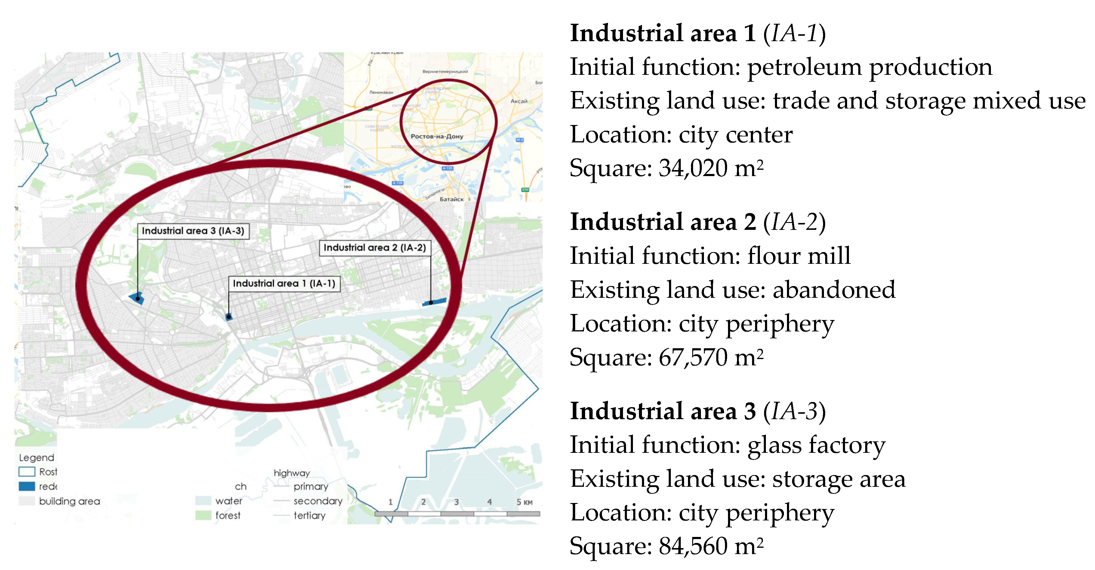
As the research materials, there are 3 industrial areas for redevelopment located in different urban conditions within the urban sprawl of the Rostov-on-Don city in Russia (Figure 1).
The purpose of the city is to implement a large-scale urban redevelopment project program aimed at solving the problems of infrastructural sufficiency of the urban environment to improve its quality and to raise land value.
All information on the existing land use inside industrial areas and on adjacent territories, as well as existing restrictions and official plans for the development of the territory, is taken from field surveys and open geodata sources.

2.3. Research Subject for Redevelopment Projects of Industrial Areas

The subject of the study is urban functions that can be designed in redevelopment projects of industrial areas. City authorities are responsible for sustainable land use of every city area, its quality of urban development, and the performance of indicators on infrastructure sufficiency, provision, security, accessibility, connectivity, comfort, and many other criteria. The list of land use functions is determined during the pre-project analysis to identify customers’ demands. The main condition for final redevelopment project of the industrial area should combine the functions defined for the location and, at the same time, be approved by the developer for construction. In any case, the decision-making process of optimal design land use solution is a multi-criteria task.
Table 2 provides a description of the groups of functions that are considered in the study.
These include three groups:
  • labor market functions that are responsible for the economic city performance of taxpayer organizations and places of employment of the working part of the population;
  • city service functions offer a set of social and public facilities necessary to ensure daily life, education, medicine, recreation, entertainment, and other spheres of life;
  • urban planning management is a set of prohibitions, requirements, and recommendations on urban land use, building control, and environmental restrictions.
Each of them presents the certain set of conditions influenced by land use that can be placed on an industrial area during its redevelopment. In one case, the city needs to form a labor market area to provide its political planning structure. In another case, there is a need to form a public center or mix-use neighborhood with a high-quality environment. The variety of redevelopment alternatives is determined by specific urban planning conditions. Aim of decision-making process in to understand the optimal scenario of redevelopment that will ensure the greatest effect of sustainable development.

3. Research Model and Methodology

3.1. Research Model

The research model describes a system of factors influencing the choice of functions to be implemented in a redeveloped industrial area. These functions provide the functional content of the land use design project. Land use functions of a redeveloped industrial area summarize the most relevant economic, environmental, and sustainability issues.
The research model provides the idea of two components: (1) the consideration of a redevelopment project in an existing urban context and (2) the assessment of social facilities’ demand by residents.
The components’ implementation takes place through the definition of the boundaries of catchment zones. Each provides the demand for various types of facilities for various groups of residents.
The research model (Figure 2) includes three types of boundaries:
  • The first boundary of a redevelopment project delimits the industrial area. Within it, the internal conditions of the industrial area are provided.
  • The second boundary of the local catchment zone delimits the area of 15-min pedestrian accessibility of the territory. It is assigned to a polycentric urban development policy and aimed at mixed-use design projects for local city district residents.
  • The third boundary delimits the city catchment zone. The area is identified as a polycenter in the planning structure of a city. Its boundary presumes functions of cultural or historical significance supposed to attract city citizens and tourists. Such area needs transport accessibility and depends on the existing modes of transport and the level of its development in the city.
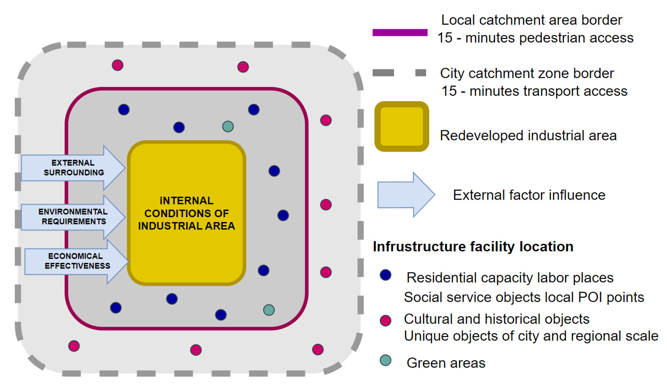
Figure 2. The research model.
Sustainability 16 09827 g002
The factors under study, that determine alternatives of industrial area land use functions are organized in 4 groups:
  • The internal industrial area environment factor describes the existing type of land use and the state of building constructions.
  • The external surrounding factor describes the role of the area in the city planning structure, conditions of transport access, and infrastructure facilities that demand conditions from different groups of customers within catchment zones.
  • The environmental requirements factor defines existing or planned environmental restrictions.
  • The factor of economic effectiveness describes the set of indicators to assess the costs of an investment project.
Multicriteria analysis of the influence of factors allows us to make a choice of alternatives to land use functions. The related decision-making method makes it possible to determine the project design solution of the industrial area considering aspects of sustainable development of the city.

3.2. The Research Methodology

The study focuses on the aim of a city sustainable development challenged by degrading of undeveloped ex-industrial urban areas. The research methodology intends to propose a comprehensive approach to identify appropriate new land use functions for every postindustrial plot basing on the analysis of precise social needs of local residents and considering the factors of environmental safety and investment attractiveness of the project for the developer. In Russia, this problem is relevant—in terms of developing practical—to oriented toolkits for city authorities to make spatial development decisions and support the developer projects that surely meet the city’s policy goals.
The study applies systematic analysis methods in order to built constituency in the process of analyzes of the current situation by developing common basic criteria. Subsequently, as the result there is the process of synthesizing the obtained data to determine the project and use functions.
Since the methodology of the study is based on the application of multi-criteria analysis, some leading experts in the field of urban environment management were involved in the expert part of the study to develop the scales of criteria evaluation. Three expert meetings held during 2023–2024 years, permitted to work out the unique evaluation scale applicable both for research and projecting.
To achieve the goal of sustainable urban development, three groups of criteria were assigned for each of the aspects under consideration—social, economic and environmental. The selection and discussion of evaluation criteria was also carried out by means of expert discussion based on the possibility of its application as a practical tool.
For obtaining the initial information the following sources were used:
-
the official City Development Plan which contains graphic representation of the boundaries of the industrial sites, limits of permitted construction parameters, current environmental restrictions;
-
open social map data which shows location and use of social, cultural, and business city focuses, identifies local community structure and groups, and various social life problems;
-
field studies data on the current territory use.
The research has been conducted since 2023 within the framework of the priority topics identified in the Russian federal project “Housing and Comfortable Urban Environment” in order to develop a methodological basis for the redevelopment process of industrial zones.
The research methodology describes the decision-making process, presents the order of actions to define project design solution for an industrial area, and includes the following stages (Figure 3):
(1)
Data collection stage. Initial data includes parameters describing the existing internal and external factors of an industrial area location, as well as existing legislative, environmental, and other restrictions and limitations;
(2)
Analysis of urban facilities’ sufficiency within catchment zones (CZ). Geospatial data analysis is used to model location and sufficiency of urban facilities within catchment zones. This stage results in the list of sufficient modes of facilities demanded within catchment zones, complied after estimating the results of spatial analysis and necessary calculations. The next step is to get combinations of alternative design solutions for the industrial area land use.
(3)
Defining land use scenario for industrial area redevelopment project. This stage includes calculations of criteria determining the scenario of land use development based on expert evaluation. The stage represents the first part of the multicriteria decision analysis.
(4)
Verifying and validating the limits of land use scenario. This stage serves for imposing conditions and limits on alternative design solutions in order to obtain a final project solution for redevelopment.
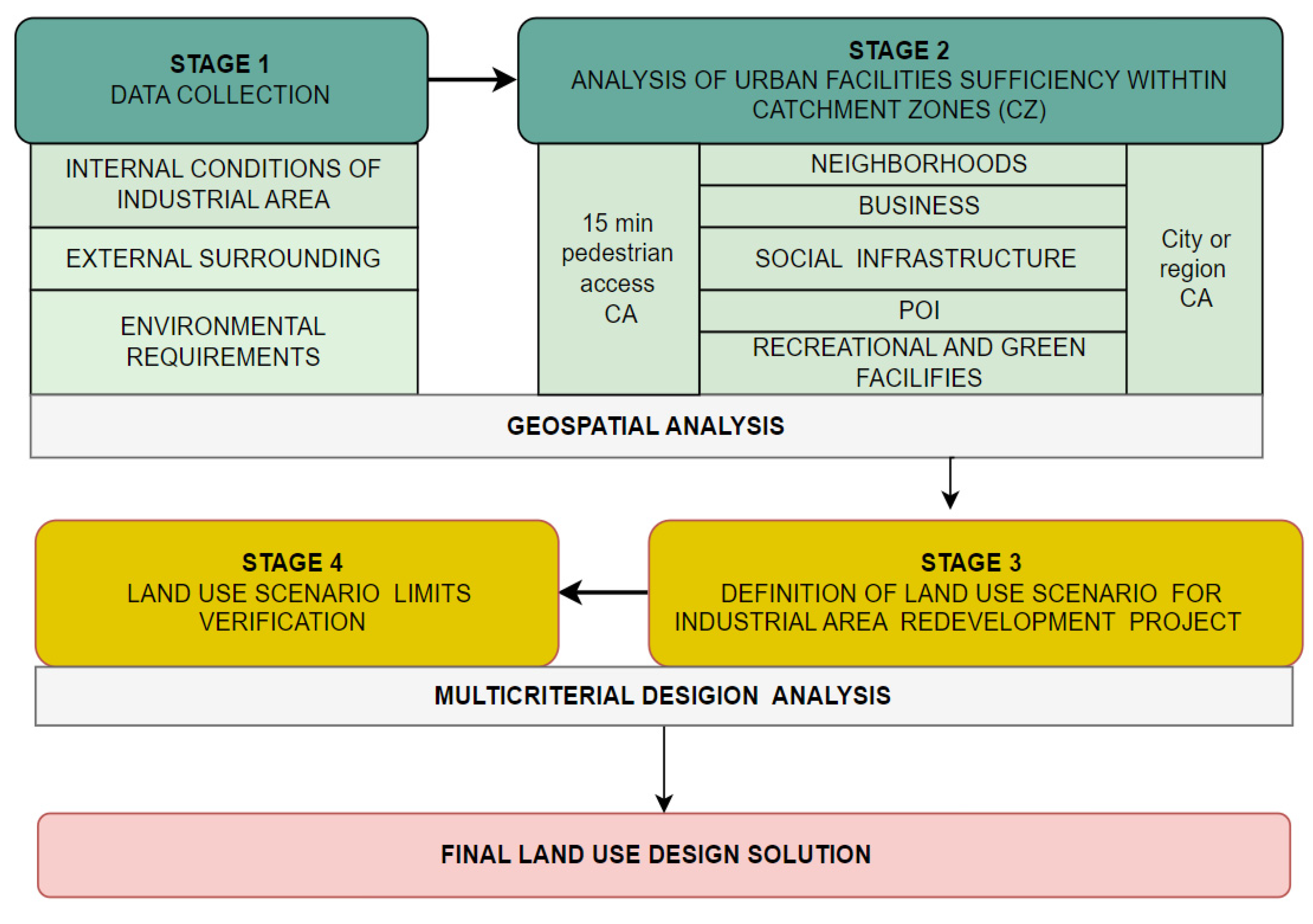
The first and second stages can be executed in parallel or sequentially. The third stage is performed sat the end in order to obtain a final project solution for redevelopment.
The initial data on the internal industrial area environment includes parameters of the current state of the industrial area: size, located infrastructure, moral and physical deterioration, and environmental restrictions. Among several options of future project can be those of demolition, reconstruction, or preservation if the structures either are in good condition or of great importance to the cultural heritage. Table 3 represents main descriptors for every stage and their application areas.
Figure 3. The research methodology for definition of land use alternatives for urban industrial areas redevelopment projects.
Sustainability 16 09827 g003
Table 3. Initial data collection stage.
FactorDescriptorApplication Area
Internal conditions of a redeveloped industrial areaArea square S, sq.m
  • Area supply
  • Current land use and its parameters
Area borders type
  • Conditions of interaction with adjacent territories
Buildings and construction structures
  • Moral and physical deterioration of existing buildings and the possibility of their reuse
  • Transport facilities
  • Engineering systems
  • Existing landscape
  • The protected status of cultural and historical heritage
External surroundingCity area type
  • The location within a city structure (city center, downtown, residential area etc.)
  • User profiles of the area
Transport access
  • Access points to the territory
  • Carrying capacity limit for car access
Public transport access
  • Access points to the territory
  • Carrying capacity limit for public transport access
Pedestrian and bicycles access
  • Access points to the territory
  • Carrying capacity limit for pedestrian and bicycles access
Environmental restrictionsSanitary protection zone
  • Determination of the hazard class of the territory
  • The establishment of a new or removal of the boundaries of the zone during the redevelopment project
Anthropogenic impact
  • Air quality, CO2 emissions
  • Physical pollution: noise, dust, vibration
  • Energy consumption, resource conservation, water consumption
Nature resource
  • Placement of the territory in the blue-green frame of the city
Project economical effectivenessInvestment effectiveness
  • The cost of the project
  • Payback period of the project
  • Profitability of the project
The initial data on external surroundings includes a number of parameters describing the location of the territory within the city. An urban historical center, a business zone, a residential area—each type is distinguished by particular parameters and nature of the development, as well as the main groups of users of the territory. The conditions for transport and pedestrian access to the territory are of most important. They set a limit on a number of users to loa in. In the context of the implementation of the policy of vehicle restrictions, priority is given to such functions that are in demand in the pedestrian or public transport access. In cases of necessity of vehicle access, the issue of organizing parking spaces becomes acute.
The initial data regarding environmental requirements is considered in three aspects. First, the environmental impact from existing industry and the presence of a sanitary protection zone. In case of redevelopment, this area can be removed to facilitate construction and lower the cost of the project. The second is the anthropogenic load from new functions: emissions, noise, vibration, dust pollution, heat island. Special attention should be paid to carbon solutions to reduce CO2 emissions, energy and resource conservation, water recycling, and other technologies for the reuse of resources. The third aspect is the possibility to include a newly developed area into blue-green framework of the city.
The data for the economic effectiveness factor of the project reflects the developer’s requirements for project profitability. It is described by complex of costs for the development of the territory, the payback period, and other investment parameters. This data is decisive and is used on the last stage of the decision-making method to define the final design solution.
The second and third stages consist of two sequential processes resulting in recommendations on land use functions and alternative design solutions for industrial area redevelopment. At the first stage, geospatial data is collected on the location of various types of infrastructure in catchment zones. Each type of facility implements a specific function. At the second stage, their sufficiency is assessed through a system of criteria that assesses the current situation and further develops alternative scenarios. Table 4 provides information on which types of spatial data are needed to calculate each of the criteria, as well as a list of them.
Data on the location of infrastructure facilities in the catchment zones is presented in the form of geoinformation maps. The first step of multicriteria decision analysis allows to determine the list of demanded land use functions for the industrial area. The highlighted functions are ranked by priority and become recommended for the development of alternative design solutions. Then, multicriteria decision analysis is used to define the final design solution by imposing various restrictions on the developed alternatives.
The list of conditions consists of 2 parts:
  • Restrictions are mandatory conditions in the field of urban policy implementation, land use restrictions, environmental safety, transport, and pedestrian accessibility.
  • Limits are a variable list of conditions imposed by the developer to provide the investment attractiveness of the project.
The research task is to determine the final design solution that will meet the imposed land use functions. It should meet the customers demand for urban facilities formed in catchment zones and the need for the most efficient use of the available territorial resource.

3.3. Sufficient Function Criteria Calculation

The scoring system for sufficient function criteria calculation was developed through a separate multi-criteria analysis study. The assignment of evaluation values was done with the involvement of experts from Academic Institution and industry professionals. The presented scale demonstrates the result of the collective expert session.
The logic of constructing the evaluation scale consisted in:
(1)
choosing the simplest form of evaluation,
(2)
choosing a universal logic of evaluation of each of the factors,
(3)
determining the gradation of intervals of the evaluation scale.
Based on these assumptions, a single scale of 4 intervals with a gradation of 0.25 units was defined. Each interval is assigned an expert grade—poor, satisfactory, good and excellent. The paper presents the results of the development of this scale.

3.3.1. The Employment-to-Population Ratio

The policy of developing polycentric, compact cities dictates the need to form local community police in various areas of the city. One of their purposes is to place local labor markets to provide the idea that people should work where they live. The territory of the industrial area is a potential point where places of employment can be located.
The employment-to-population ratio is a measure of the number of people employed against the total working-age population within the local catchment zone (1).
K1 = NLFE/NTP,
where
  • NLFE—labor force employed (16–65 years), persons
  • NTP—total working-age population within a catchment zone, persons
If the coefficient shows a lack of labor places, then the recommended function for the projected territory is the labor market and business function. Another case provides provide solution to organize mixed-use neighborhoods or public spaces.
To decide on the choice of a scenario for planning development, the interpretation of the criteria w-value evaluation scale is given in the Table 5.

3.3.2. Sufficiency of Social Facilities

Social facilities include those functions that ensure the daily life of the population. There are kindergartens, schools, educational centers, policlinics and medical centers, banks, and public service centers. The availability of social facilities is assessed by the spatial analysis method that determines the next indicators:
  • Provision (P) of objects in the local catchment zone
  • Availability (Av) as location density per the number of residents
  • Accessibility (Ac) as a radius of 400 m pedestrian access
Table 6 shows the w-value evaluation scale for CR2 criterion.

3.3.3. Sufficiency of Local Points of Interest

Points of local interest facilities include those functions that provide cultural and entertainment life functions within the 15-min catchment zone. There are trade, food, cultural, entertainment, and sports facilities. Their sufficient assessment is estimated similarly to the CR3 spatial analysis method. Table 7 shows the w-value evaluation scale for the CR3 criterion.

3.3.4. Sufficiency of Green Areas

The green area facilities include those functions that provide blue-green infrastructure protection and recreational functions for the population. There are all types of green areas, unique natural elements, and parks of various scales, from pocket parks to vast urban forests.
Their sufficient assessment is estimated similarly to the CR4 spatial analysis method. The priority of the green facilities arises if there are valuable natural elements on the territory or on the adjacent territory—greening, water bodies, landscape, and other elements of the city’s blue-green framework. In another case, it is possible to create an artificial natural landscape.
Table 8 shows the w-value evaluation scale for this CR4 criterion.

3.3.5. Sufficiency of City Points of Interest

The city points of interest (POI) facilities include those functions that provide external attractiveness of the area for city citizens and tourists.
There are various types of cultural, entertainment, cultural-historical, transport, and other significant multifunctional facilities to attract people from the city catchment zone.
Their sufficient assessment is estimated by the spatial analysis method. The difference is that the entire city is accepted as a consideration area. The necessary information on significant city facilities and plans for their construction is taken from urban development documents. Based on the application of significant public facilities of urban significance, the indicators of their provision, availability, and accessibility are similarly evaluated.
A significant indicator for the placement of an urban point of interest is the presence of objects of cultural or historical value, as well as the presence of a tourist business in the city.
In combination with the location in the central areas of the city and sufficient conditions for transport access, priority decisions are made for the placement of multifunctional cultural and community centers.
Table 9 shows the w-value evaluation scale for this CR5 criterion.

3.4. Multicriteria Decision-Making Analysis for Land Use Functions in an Industrial Area Redevelopment Project

The multicriteria decision analysis includes two stages of determining the final land use option for the industrial area. The purpose of the redevelopment is to identify the functions demanded by citizens in the area of its location within the city structure of the city. These conditions impose restrictions on the area’s development. Thus, the first stage is aimed at forming the final scenario Ffinal of demanded land use. The purpose of the second stage is to assess potential constraints that affect the implementation of planned functions and the final project cost.
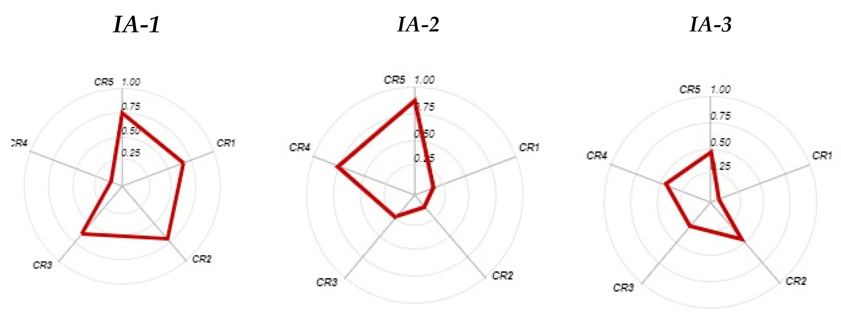
The logical framework of the first stage presented on the Figure 4 starts from a graphical image of w-values for every criterion on the ray diagram. The corresponding w-value = {0;1} is stored on each of the axes.
The developed evaluation criteria assessment proposed in the Section 3.3. of this study is presented in the form of framework on Figure 5. Each cell is defined by one of the 4 ranks of priority evaluation in decision making. This evaluation system was developed basing on following assumptions:
(1)
priority realization of functions demanded in the area of industrial area location. For example, compensating for the lack of social services in the new residential development to meet the needs of the surrounding areas or maintaining the light industry function in case of lack of jobs in the 15-min catchment zone;
(2)
support of the city’s established development pattern. For example, locating mixed-use residential zones in peripheral areas of predominantly residential development or developing the public function of the city center;
(3)
implementation of the existing resource. For example, realization of recreational function in case of valuable natural resources.
According to a horizontal row of the table, the assessment is carried out to choose the main functional scenario of redevelopment. For each of the columns, variants of a facilities set are determined.
Figure 5. The ranking scale for assessing the land use functions priority for an industrial area redeveloping.
Sustainability 16 09827 g005
Alternative scenarios can be formed by the different w-value sets. Their definition is based on the following conditions:
  • Function sets are primarily composed of functions of 1 or 2 priority.
  • Preference should be given to a set of functions that will be combined with each other and create a complete solution. For example, residential buildings, social facilities, and local POI, or an urban community center and a green zone, a light industry center, and an urban community center.
To evaluate alternatives, an integrated calculation of the technical and economic parameters of the project is carried out.
Final land use scenario Ffinal and facilities components are defined by evaluation of maximum w-values.
At the second stage, the land use scenario Ffinal can be corrected during the process of its verification. Required correction can be provided through a system of existing urban limits—restrictions or requirements that lead to a change in the project cost. Table 10 presents a set of them on the main external and internal conditions according to the research model as well as environmental requirements.
The final land use function for the industrial area redevelopment project is a solution that ensures the investment profitability CREQ for the land use solution Ffinal. This value is defined by the developer. Mathematically, the final design solution will be considered the one for which the project cost will be as close as possible to the specified parameters of the investment efficiency of the project CREQ.

4. Results

Case Study

Rostov-on-Don is one of the largest cities in the European part of Russia and the administrative center of the Rostov region. The accessibility of the largest Don River transport artery, the favorable climate and the location on the way between the Black Sea and the capital of the country in the past and in the present make the region the industrial center of the country.
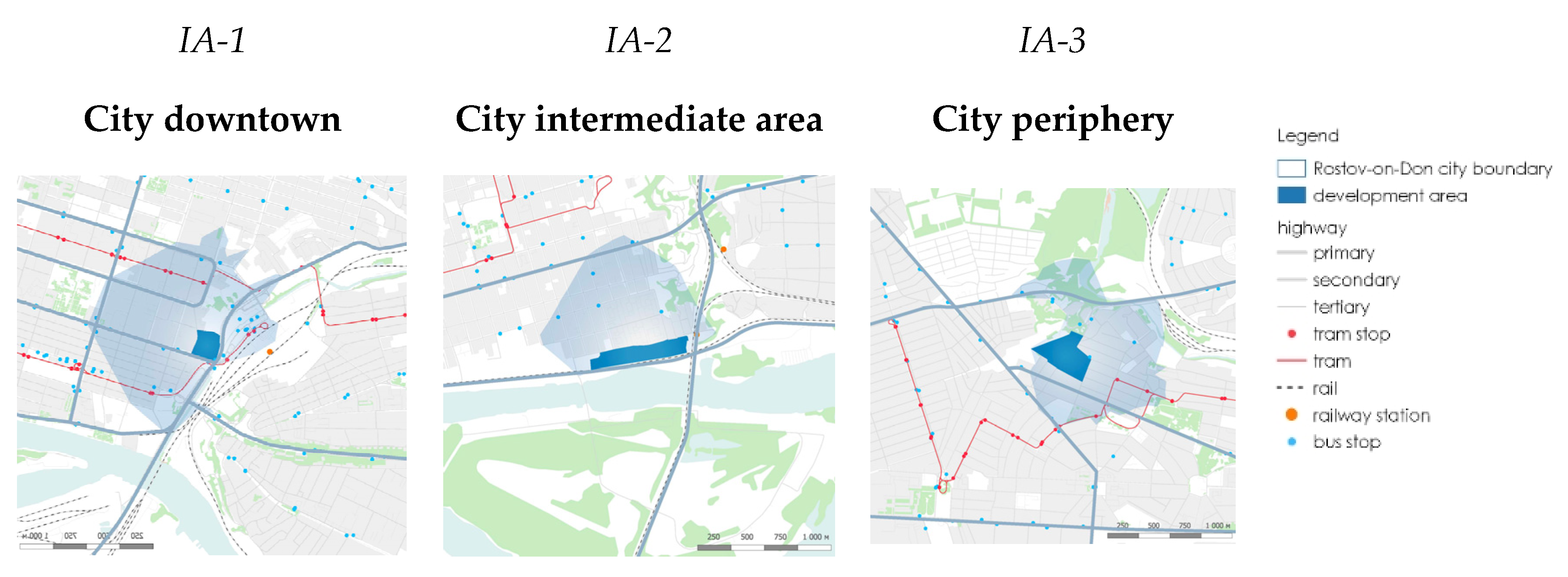
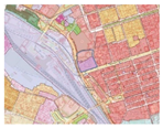
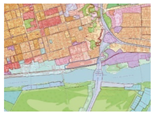
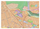
The Rostov-on-Don city is the industrial center of the region, and historically, there have been many industrial areas on its territory. During urbanization, many of them ceased to perform their original functions. Currently, they represent either abandoned areas or uncontrolled business concentrations. Three zones were identified for the case study, located in different urban conditions (Figure 6).
They all have common features for redevelopment, such as:
  • they are parts of the existing functional city structure without any social functions;
  • they have transport, public transport, and pedestrian access points;
  • they are not used for their intended purpose;
  • they represent depressed urban areas.
The industrial area 1 (IA-1) is located in the central part of the city. In the past, it was the production of petroleum materials, but it hasn’t been preserved at the present time. The specific feature of the area’s location is that it is adjacent to the main transport hub of the city. Transportation services include access by road, commuter, and heavy rail, as well as on-land passenger transport. The territory is part of the downtown city area and has excellent pedestrian access conditions. The existing territory for land use trading and warehousing is chaotic and uncontrolled.
The industrial area 2 (IA-2) is located on the bank of the wide Don River. It is a former flour factory. Currently, there is an intensive process of housing construction with a high density around the perimeter. The territory has access from the city collector street, by public transport, as well as by public waterways. The peculiarity of the area is that it adjoins valuable natural green areas along the river, which are intensively used by the inhabitants for recreational purposes. Currently, the territory is abandoned and not in use.
Industrial area 3 (IA-3) is located within existing residential development in the peripheral part of the city. It has access from city collector street and public transport. Previously, it was the glass factory, which is currently not functioning. The territory is used by uncontrolled businesses and warehouses.
The initial data for the case study is presented according to the developed methodology (stage 1) collected by the spatial analysis of areas location within the 15-min catchment zone as well the city borders. Main descriptors of the existing urban situation are the open source data from map and official city sites.
Special attention is paid to the analysis of an area transport access condition. These include the entrance points and bus and rail stations. Future area function directly depends on the type of public transport and its capacity. In our case, the IA-1 territory has a greater access capacity due to the availability of the main transport regional transport hub. In the case of IA-2 and IA-3, the access capacity is limited by the presence of only city routes.
The last feature of initial data analysis is environmental limits. In our case study, all three industrial areas were selected that do not have a sanitary protection zone and are included in the urban structure without environmental restrictions (Table 11).
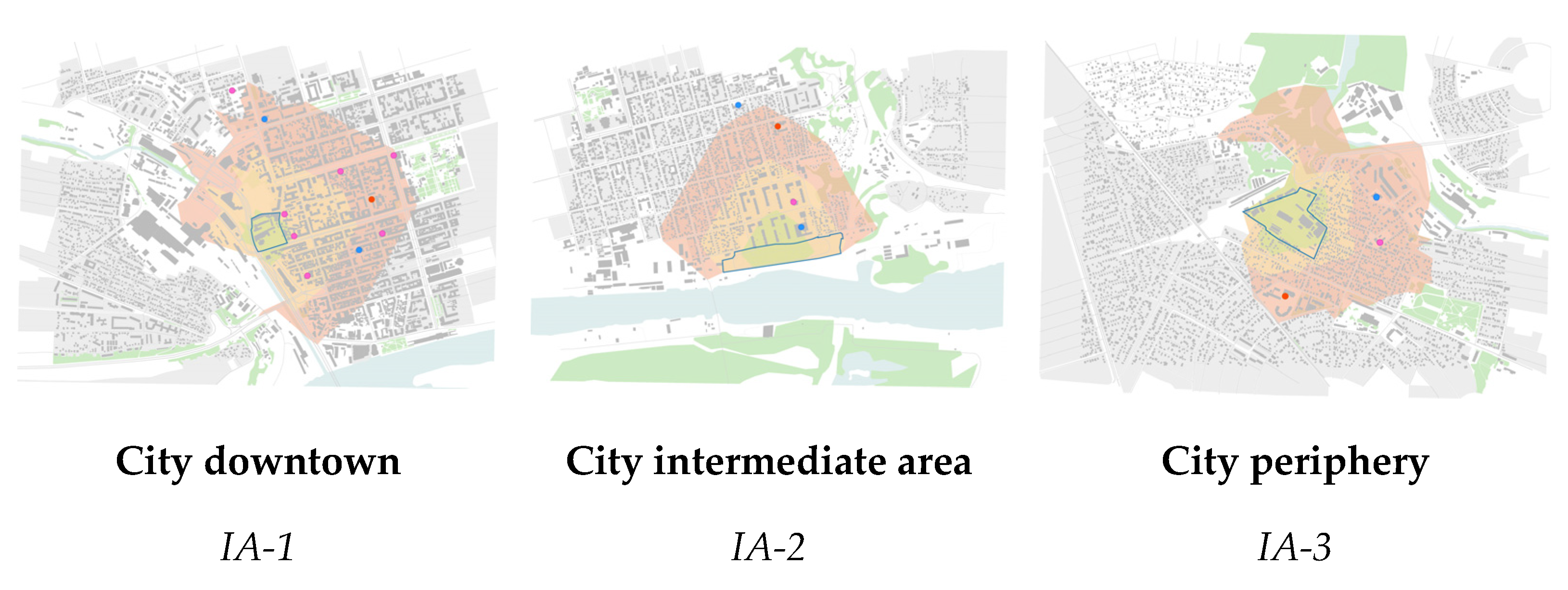
Geospatial data analysis (methodology stage 2) is carried out using GIS technologies to assess facilities sufficiency and its demand population in 15 min pedestrian catchment zone (Figure 7). Boundaries of a zone may be artificial barriers, such as railways in IA-1 or natural barriers, such as a river in IA-2.
For each catchment zone, the data is collected on the location of various facility types. It is used for further obtaining the calculated values of the weights w-value of an criteria.
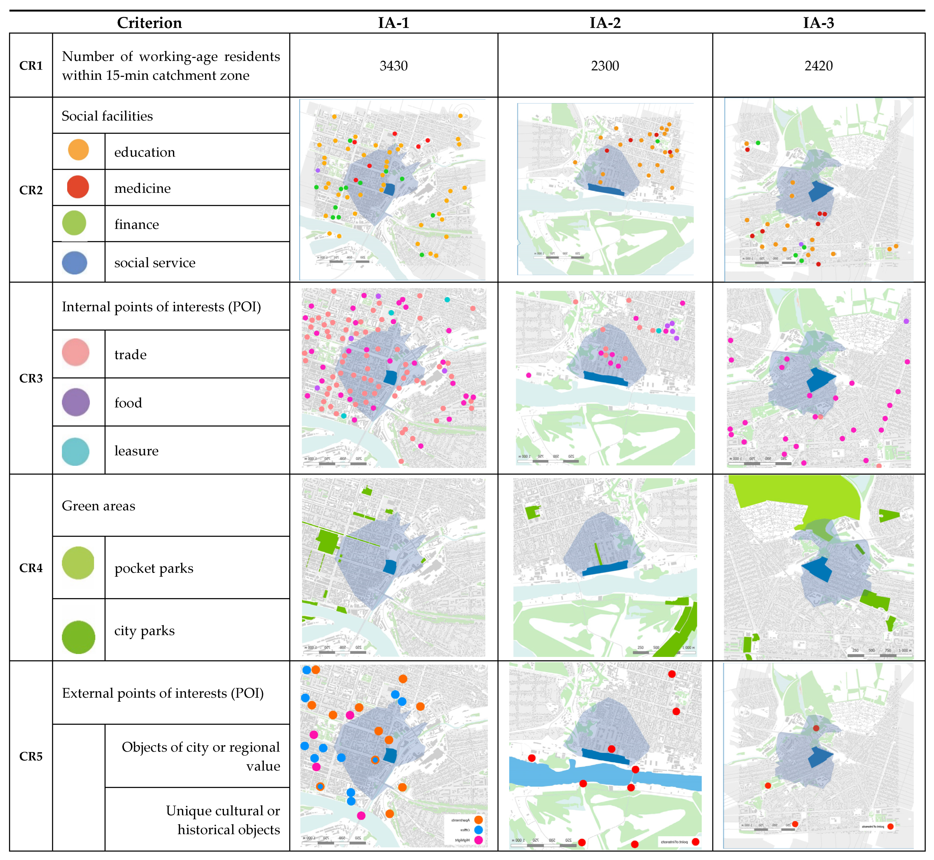
For a catchment zone, three criteria (CR2CR4) are considered using the results of the spatial location of different facilities. The analysis shows that the facility composition in every catchment zone depends on the surrounding situation (Figure 8).
The criteria CR5 is assessed within the city catchment zone. The choice of city or regional functions for assessment for this criterion is based on the knowledge of the city urban planning experts as well as the urban context analysis. It shows that each industrial area has a different value in the city.
  • IA-1, located in the zone of influence of the railway station and in the city area of public and business function accumulation;
  • IA-2 is located on the riverbank with recreational and natural area value and is a potential part of the blue-green framework of the city;
  • IA-3 is located within residential neighborhoods and has no special value.
The criteria The CR1 criterion is calculated based on the total number of labor places at facilities located in a 15-min catchment zone of pedestrian accessibility and statistical data on the number of people within the area.
All criteria are evaluated according to the multicriteria decision analysis methodology proposed by the authors. For each criterion, a weight w-value is determined based on spatial and statistical data. The assessment w-value weights of each criterion is presented in Table 12 and on the ray diagrams (Figure 9).
IA-1 is characterized by fairly high estimated w-values compared to other cases. Priority functions are f2—light industry (CR1 = 0.66) and f5—city public space (CR5 = 0.74).
IA-2 is characterized by priority w-values f5—city public space (CR5 = 0.80) and f4—local public space (CR4 = 0.8). The area’s peculiarity is its inclusion in the blue and green framework of the city, which emphasizes the need to develop a green recreational function.
IA-3 is characterized by priority w-value of f1—residential area (CR1 = 0.1). The criterion characterizes the existing residential development of the peripheral part of the city and the lack of places of employment. The formation of a comfortable environment requires the development of deficient functions of f3—social service (CR3 = 0.26) and f4—local public space (CR3 = 0.25). The priority land use is to create a mixed-use neighborhood and to offer labor places to the residents in the 15-min catchment zone.
The next step is to assess the resulting ray diagrams with the involvement of experts and potential developers of the territory. The evaluation of the w-value of each of the criteria along the axis, as well as a comprehensive vision of the situation, allows us to provide two conclusions on different scales: (1) a redevelopment scenario on the scale of a city and (2) a list of land use functions that will be in demand on the scale of an industrial area.
The analysis of the case study obtained results indicates the common direction of mixed land use for industrial areas. However, each area has a distinct scenario and the priority set of functions (Table 13).
The second stage of the multicriteria decision analysis provides the assessment of limit conditions for the definition of the final land use function for industrial area redevelopment projects by expert means. Finally, it is expressed in determining the added value of the project or building restrictions. The results are presented in Table 14 in the form of general data on their accounting.
The article does not provide an estimate of the cost-effectiveness of projects. The main attention is paid to checking methodology to solve the urban planning problem how define a land use scenario for an industrial area, improve the conditions of functional filling of urban areas, and improve the quality of the urban environment.
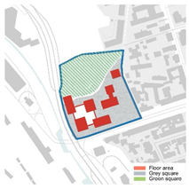
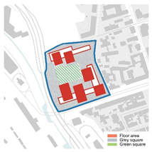
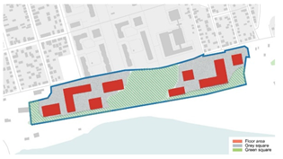
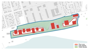
To assess the investment effectiveness of the project, a comprehensive calculation of its cost was carried out for various parameters of the built-up area during redevelopment. For each of the industrial area, three land use solutions have been developed with different options for the distribution of the share of various types territories. For an enlarged economic assessment, build up sites, gray areas for transport communications and parking lots and green areas for natural objects and landscaped areas were selected. For each of the land use options, the cost of the project was determined based on the aggregated calculations of the certain type construction of building in accordance with the assigned function of the territory.
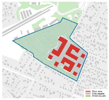
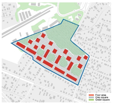
Industrial zone 1 is designed to accommodate the Public and business center, which includes buildings for the organization light industrial, business center, offices, coworking, shopping center, as well as public spaces. Table 15 presents three land use layouts for the construction. They differ in the type of buildings—from tall towers of 20–30 floors, to distributed buildings with a maximum number of floors of 15 floors.
Industrial Zone 2 is intended to house the cultural and recreational public center, which includes education, entertainment and leisure, trade and food, sports and health facies, as well as a park area along the river. The availability of a natural resources and activities for their protection are considered in the consolidated cost of environmental protection measures, as well as the increased cost of engineering solutions to reduce anthropogenic impact. Table 16 shows three land use options for the territory, which differ in the percentage of development and the percentage of green areas.
Industrial Zone 3 located on the periphery of the city is intended to accommodate residential mixed-use neighborhood, which includes residential buildings, kindergarten and schools, trade and food, social services, as well as public spaces for leisure and sports. Since the analysis shows a low provision of social facilities in neighboring territories, it implies an improvement in the general conditions in the area due to new construction. Table 17 shows the results of calculations of three types of land use for a residential area: point high-rise buildings, lower buildings, but with a larger area of land coverage, and buildings with maximum land development indicators, but with a minimum number of floors.
In the article, these calculations are given for an indicative comparison of the results of economic assessment as the last stage of the developed research methodology. In each case, the decision on the expediency of building a land-use option is made by the developer, based on his monetary capabilities.
As visualizations of the final solutions, Table 18 shows graphical images of the development of each of the territories according to one of the options. They clearly reflect the main goal of redevelopment, which is to create a high-quality urban environment.
Project visualizations are performed using neural networks with the specified project parameters. The developed land use for the industrial area redevelopment project provides a reasonable choice of urban functions demanded within its location in the city structure. The main aim is to combine social needs in facilities with a project—cost effectiveness and environmental limits.
The developed methodology fulfills the objectives of urban policy for its sustainable development, as well as increasing the attractiveness of urban areas, expanding opportunities for their residents, and generally improving the quality of the urban environment.

5. Discussion

Discussion questions related to the results of the case study concern as the process of decision-making so the methods used to make a decision. Practically, the cost-effectiveness is of the most importance for managing the project, while it depends basically on the demand of services and goods to be placed. The aims of demand research and further decision-making primarily depend on the needs of the city and its residents.
This study follows the concept of prioritizing socio-economic aspects of urban environment development. Literature review shows numerous works that successfully address sustainability challenges at developing plans using the same approach [45,46].
The research of Fernandez & Ruiz [3] is aimed at planning sustainable industrial areas, industrial activities is in balance with the environment.
Works of Coppola et al. [31], investigate the relation between different urban spatial forms and sustainability. Testing and comparing alternative scenarios of urban forms through a scenario analysis tool, with further evaluation of the results, he arrives at the conclusion in favour of the compact development, that appears to perform better in achieving economic, environmental and social goals.
Results of the research made by Shinya F.; Dang A. L. [6] draw them to the conclusion that mixed land-use, loose restriction of zoning districts and lack of localization economies of the factory promote factory land redevelopment, thus, encouraging governmental investments.
The need to develop the integration of smart cities in order to provide smarter and responsive urban environment, is demonstrated through the investigation of three sample case studies carried out by Ragab A. and others [27]. The authors focus attention on the actual topic of carbon footprint of three different well-established industries of three different volumes and, receiving unexpected results, point out the importance of combining LCA with artificial intelligence and machine learning in order to avoid many uncertainties in early stages of design on all industrial scales.
Since we believe that historic preservation and assigning new functions to historical industrial sites is also important, planning solution for our case study 2 is based on such approach, we agree with Jato-Espino et al. [9] who suggests the necessity of new tools to support adaptive reuse of industrial facilities, in order to leave testament of their cultural and industrial heritage once their production activities cease to exist. While, the research by Chuli and others et al. [28] investigates the mechanisms of public perceptions and preferences for post-industrial landscapes. The findings of the authors indicate the need to use natural landscape elements as alleviating stress and promoting restoration, plant flowering shrubs and reserve industrial construction with the sense of historical value.
The promising direction of industry 5.0 is discussed in the research of Rame R. et al. [8]. Examining interrelations between Industry 5.0 and sustainability, the authors demonstrate the potential of a new trend to address sustainability. Aimed to contribute to academic discourse with fresh insights into aligning new technologies with environmental and social goals, the authors offer also practical implications for different actors.
Named already the Fifth Industrial Revolution, the phenomenon of Industry 5.0 provides future research directions and require new knowledge and skills from scientists, engineers, workers.
Interdisciplinary nature of data analytics, skill gaps, big data analytics, artificial intelligence, required in implementing smart 5.0 industry solutions, are quite challenging for the researches, though changes, improvements, advantages, case study experiments are already discussed. For example, a complex adaptive system perspective is presented in the work of Cinthia Satornino et al. [17] that studies the experience of using artificial intelligence (AI) to advance sustainable development in industrial markets.
Thus, implementation of 5.1 industry approach in smart urban development seems to be a very promising research area.
Review of the studies related to the results of our work reveals that basing on the same concept and aiming enhance cities’ capacity to transition towards sustainability through redeveloping industrial cites within the cities, different researchers differ in methods. Also, the studies are non comprehensive, they lack detailed analysis of socio-economic and environmental aspects, investment efficiency and interaction with stakeholders: each of the questions could the subject of a separate study and requires a special methodology.

6. Conclusions

The research results application lies in the field of sustainable built environment design. Most cities have their own history of territorial development, and many of them are in a depressed state now. The urbanization process in cities leads to the need for efficient use of every square meter with maximum social and economic benefits. Also, the current trend of removing industrial enterprises outside the city generates free territories that can be used for development. Industrial areas are one of the most common areas that require redevelopment. The existing building construction practice shows the debatable issue of choosing their new designation. Right functions require the selection to be in demand by different groups of residents in a particular location of the city.
Industrial areas are valuable urban areas. As a rule, they have a significant role as a part of the built-up city area. Therefore, it is important to make decisions on their spatial development, considering the urban context as well as the location of those functions that will contribute to improving the quality of life of residents of the city. Such urban sites become points of developer interest. The main aim of the research is to make them both point of interests for the population. This ensures the achievement of city sustainable development and the overall improvement of the quality of the urban environment.
The scientific novelty of the research results is determined by the developed method of decision-making on land use functions in the redevelopment project of the industrial zone, taking into account the specifics of Russian cities. It is important to contribute to the sustainable development of cities that are facing the consequences of urbanization processes. The research topic opens up a wide range of further academic research in the field of studying multi-disciplinary tasks.
In practical aspect the study is aimed at achieving SDG 11 targets for a city. The main issue is to return the area in the socio-economic life of the city and to improve the environment.
The research approach is based on the two main aspects that allow to reach SDG targets: (1) the need to consider the urban context of the area location in a city structure and (2) the replenishment of land use functions that will be in demand by the residents in the 15-min pedestrian accessibility zone.
The research methodology uses geospatial analysis and multicriteria analysis as the decision-making tool for determining land use functions for an industrial area redevelopment. The use of GIS technology allows to visually present information for its processing and final decision-making.
During the study, more than 10 industrial areas in various cities were considered; three industrial areas were selected to present the case study, which demonstrate the difference in decision-making on determining land use functions depending on the urban context. As a result, examples of design solutions have been developed for each zone to visually present the results of the case study.
Finally, the main research results are:
  • Based on the developed methodology social, economic and environmental aspects are summarized for a land use project for the redevelopment of an industrial zone to ensure a contribution to the sustainable development of the city
  • The evaluation criteria are determined and a method for evaluating the spatial location of the industrial redevelopment zone in the city is presented for two catchment zones of 15-min pedestrian accessibility and transport accessibility to determine the required land use functions
The implementation of the developed methodology and the results of spatial planning are presented on the example of three cases of industrial areas in Rostov-on Don. Despite the fact that the proposed methodology has been developed and tested on the example of Russia, it can be extended to other cities in different countries. This idea is based on the fact that the goals of sustainable urban development are the same all over the world. Also, the goals of the city policy are the same to create a comfortable urban environment, provide infrastructure sufficiency for residents, ensure the safety of the urban environment and solve typical problems with the quality of life of the population. The prerequisites for our research are based on an analysis of existing world experience and are extended to Russian cities. The specific features of the methodology reflecting the specifics of Russia can only be the processes of organizing interaction between the authorities, developers and residents, as well as a feature of the socio-economic way of life of the population. However, these factors can also be considered applying the developed methodology to other cities of the world by slightly adapting its elements without changing the basic structure.
Despite the limit related to evaluating investment effectiveness, case study is a comprehensive report that provides a powerful tool to analyse and find solutions to complex problems redevelopment of industrial zones. It can be used to continue scientific research, as well as solve problems confronting our cities today.

Author Contributions

Conceptualization, N.D.; methodology, N.D.; software, A.K.; validation, N.D. and I.T.; formal analysis, A.K. and I.T.; investigation, A.K.; resources, A.K. and I.T.; data curation, I.T.; writing—original draft preparation, N.D.; writing—review and editing, N.D. and I.T.; visualization, A.K.; supervision, N.D.; project administration, N.D. All authors have read and agreed to the published version of the manuscript.

Funding

The research was funded by the National Research Moscow State University of Civil Engineering (grant for fundamental and applied scientific research, project No. 10-392/130).

Institutional Review Board Statement

All ethical principles are observed.

Informed Consent Statement

Written informed consent has been obtained from the patient(s) to publish this paper.

Data Availability Statement

All ethical principles are observed.

Conflicts of Interest

The authors declare no conflicts of interest.

References

  1. Loures, L.C.; Panagopoulos, T. Sustainable reclamation of industrial areas in urban landscapes. Sustain. Dev. 2007, 102, 791–800. [Google Scholar]
  2. Cannatella, D. Industrial Transformation and Sustainable Urban Planning in the Pearl River Delta: A Landscape-based Approach. In Adaptive Urban Transformation; Nijhuis, S., Sun, Y., Lange, E., Eds.; Springer: Cham, Switzerland, 2023; pp. 209–232. [Google Scholar] [CrossRef]
  3. Fernández, I.; Ruiz, M.C. Descriptive model and evaluation system to locate sustainable industrial areas. J. Clean. Prod. 2009, 17, 87–100. [Google Scholar] [CrossRef]
  4. Han, Z.; Xie, W.; Yu, H.; Xie, H.; Li, Y.; Wang, Y. Rethinking industrial land-use in American rust cities towards sustainability based on a block-level model. J. Environ. Manag. 2024, 352, 120067. [Google Scholar] [CrossRef]
  5. Wang, B.; Tian, L.; Yao, Z. Institutional uncertainty, fragmented urbanization and spatial lock-in of the peri-urban area of China: A case of industrial land redevelopment in Panyu. Land Use Policy 2018, 72, 241–249. [Google Scholar] [CrossRef]
  6. Fukui, S.; Luong, D.A. Impact of diseconomy of mixed land-use on factory land redevelopment in large urban area: Evidence from Japan. Jpn. World Econ. 2024, 71, 101256. [Google Scholar] [CrossRef]
  7. Lai, Y.; Chen, K.; Zhang, J.; Liu, F. Transformation of Industrial Land in Urban Renewal in Shenzhen, China. Land 2020, 9, 371. [Google Scholar] [CrossRef]
  8. Rame, R.; Purwanto, P.; Sudarno, S. Industry 5.0 and sustainability: An overview of emerging trends and challenges for a green future. Innov. Green Dev. 2024, 3, 100173. [Google Scholar] [CrossRef]
  9. Jato-Espino, D.; Martín-Rodríguez, Á.; Martínez-Corral, A.; Sañudo-Fontaneda, L.A. Multi-expert multi-criteria decision analysis model to support the conservation of paramount elements in industrial facilities. Heritage Sci. 2022, 10, 68. [Google Scholar] [CrossRef]
  10. Li, Q.; Li, W. Availability evaluation for current status of old industrial area in China: From the perspective of sustainable development. Environ. Technol. Innov. 2021, 23, 101743. [Google Scholar] [CrossRef]
  11. Luna, J.; Diego, I.; Hernando, M.A.; Fdez-Arroyabe, P.; Ruiz-Puente, C. Analysis and development of factors to locate sus-tainable industrial areas. WSEAS Trans. Environ. Dev. 2005, 1, 258–264. [Google Scholar]
  12. Deng, P.; Huang, Q.; Liu, F.; Wang, Z.; Liu, M. The research on identification and spatial pattern of urban mixed land-use: A case study of Chengdu. Ecol. Indic. 2023, 154, 110891. [Google Scholar] [CrossRef]
  13. Hu, Q.; Shen, W.; Yan, J.; Kong, W.; Li, W.; Zhang, Z. Does existing mixed land development promote the urban spatial composite function? Evidence from Beijing, China. Land Use Policy 2024, 143, 107212. [Google Scholar] [CrossRef]
  14. Gao, J. Spatial restructuring and the logic of industrial land redevelopment in urban China: IV. A case study of jointly redevelopment by multi-actors. Reg. Sustain. 2023, 4, 44–53. [Google Scholar] [CrossRef]
  15. Gu, H. Differential impacts of urban revitalization projects on land prices: A case study of Seongnam, South Korea. Cities 2024, 154, 105256. [Google Scholar] [CrossRef]
  16. Ruiz, M.C.; Romero, E.; Pérez, M.A.; Fernández, I. Development and application of a multi-criteria spatial decision support system for planning sustainable industrial areas in Northern Spain. Autom. Constr. 2012, 22, 320–333. [Google Scholar] [CrossRef]
  17. Satornino, C.B.; Du, S.; Grewal, D. Using artificial intelligence to advance sustainable development in industrial markets: A complex adaptive systems perspective. Ind. Mark. Manag. 2024, 116, 145–157. [Google Scholar] [CrossRef]
  18. Li, G.; Wang, Y.; Zhou, S.; Lu, Z.; Yin, T. Effectiveness and challenge of environmental impact assessment in industrial park, a case study in Northeast rust belt China. Innov. Green Dev. 2023, 2, 100072. [Google Scholar] [CrossRef]
  19. Pandas, A. Redevelopment of industrial zones as a tool of city development. Econ. State J. 2019, 12, 64–67. [Google Scholar]
  20. Kim, J.-I. The suburbanization of firms with multiple labor inputs: From monocentricity to polycentricity. Transp. Res. Part A Gen. 1991, 25, 57–58. [Google Scholar] [CrossRef]
  21. Klink, J.J.; Ignatios, M.F. Reform, redevelopment and rent: Dilemmas of the social function of property in the private domain of the Brazilian metropolis. Geoforum 2024, 148, 103936. [Google Scholar] [CrossRef]
  22. Ravaz, B.; Bombenger, P.-H.; Capezzali, M.; Meyer, T. Reviewing 20 years of redevelopment trajectories of industrial sites literature and highlighting new research perspectives. Land Use Policy 2024, 146, 107326. [Google Scholar] [CrossRef]
  23. Rhoads, D.; Solé-Ribalta, A.; Borge-Holthoefer, J. The inclusive 15-minute city: Walkability analysis with sidewalk networks. Comput. Environ. Urban Syst. 2023, 100, 101936. [Google Scholar] [CrossRef]
  24. Duarte, C.M.; Fernández, M.T. The influence of urban structure on commuting: An analysis for the main metropolitan systems in Spain. Procedia Eng. 2017, 198, 52–68. [Google Scholar] [CrossRef]
  25. Frank, L.D.; Smith, M.S.; Matthews, E.Q. Assessing Transit Station Area Redevelopment: A Case Study of the Lindbergh Station in Atlanta. J. Public Transp. 1999, 2, 21–53. [Google Scholar] [CrossRef]
  26. Yen, B.T.H.; Feng, C.-M.; Lee, T.-C. Transit-oriented development strategy in Taiwan: An application of land value capture. Asian Transp. Stud. 2023, 9, 100094. [Google Scholar] [CrossRef]
  27. Ragab, A.; Osama, A.; Ramzy, A. Simulation of the Environmental Impact of Industries in Smart Cities. Ain Shams Eng. J. 2023, 14, 102103. [Google Scholar] [CrossRef]
  28. Huang, C.; Wei, F.; Qiu, S.; Cao, X.; Chen, L.; Xu, J.; Gao, J.; Lin, Q. Interpreting regenerated post-industrial lands as green spaces: Comparing public perceptions of post-industrial landscapes using human factor design framework. Ecol. Indic. 2023, 157, 111282. [Google Scholar] [CrossRef]
  29. Le, M.K.; Zhu, J.; Nguyen, H.L. Land redevelopment under ambiguous property rights in transitional Vietnam: A case of spatial transformation in Hanoi city center. Land Use Policy 2022, 120, 106290. [Google Scholar] [CrossRef]
  30. KOMAROVSKA, A.; Ustinovichius, L.; Shevchenko, G.; Nazarko, Ł. Multicriteria evaluation of commercial industrial zone development. Int. J. Strat. Prop. Manag. 2015, 19, 84–95. [Google Scholar] [CrossRef]
  31. Coppola, P.; Papa, E.; Angiello, G.; Carpentieri, G. Urban form and Sustainability: The Case Study of Rome. Procedia Soc. Behav. Sci. 2014, 160, 557–566. [Google Scholar] [CrossRef]
  32. Wiśniewski, R.; Rydzewski, M. Community centers in local communities—Norms and praxis. institutions and their stakeholders. Polityka Społeczna 2022, 582, 20–26. [Google Scholar] [CrossRef]
  33. Zhang, L.; He, X.; Jia, Z. Industrial agglomeration, public services and city size: Evidence from 286 cities in China. Land Use Policy 2023, 131, 106758. [Google Scholar] [CrossRef]
  34. Chen, K.; Lai, Y.; Tao, L.; Lin, Y. Spatial Variation of Industrial Land Conversion and Its Influential Factors in Urban Redevelopment in China: Case Study of Shenzhen, China. J. Urban Plan. Dev. 2024, 150. [Google Scholar] [CrossRef]
  35. Dong, W.; Gao, X.; Chen, X.; Lin, L. Industrial Park Renovation Strategy in a Poverty-Alleviated County Based on Inefficient Land Evaluation. Sustainability 2023, 15, 10345. [Google Scholar] [CrossRef]
  36. Chen, I.-C. Predicting regional sustainable development to enhance decision-making in brownfield redevelopment using machine learning algorithms. Ecol. Indic. 2024, 163, 112117. [Google Scholar] [CrossRef]
  37. Wu, W.; He, F.; Zhuang, T.; Yi, Y. Stakeholder Analysis and Social Network Analysis in the Decision-Making of Industrial Land Redevelopment in China: The Case of Shanghai. Int. J. Environ. Res. Public Health 2020, 17, 9206. [Google Scholar] [CrossRef]
  38. Wang, Z.; Chen, X.; Huang, N.; Yang, Y.; Wang, L.; Wang, Y. Spatial Identification and Redevelopment Evaluation of Brownfields in the Perspective of Urban Complex Ecosystems: A Case of Wuhu City, China. Int. J. Environ. Res. Public Health 2022, 19, 478. [Google Scholar] [CrossRef]
  39. Jin, R.; Huang, C.; Wang, P.; Ma, J.; Wan, Y. Identification of Inefficient Urban Land for Urban Regeneration Considering Land Use Differentiation. Land 2023, 12, 1957. [Google Scholar] [CrossRef]
  40. Radziszewska-Zielina, E.; Adamkiewicz, D.; Szewczyk, B.; Kania, O. Decision-Making Support for Housing Projects in Post-Industrial Areas. Sustainability 2022, 14, 3573. [Google Scholar] [CrossRef]
  41. Preka, R.; Tarantini, M.; Dominici, A.; Litido, M.; Segreto, M. Building Sustainable Industrial Areas: Experience and Perspectives from the Mediterranean and Western Balkan Countries. Eur. J. Sustain. Dev. 2013, 2, 97–108. [Google Scholar] [CrossRef]
  42. Pazzini, M.; Corticelli, R.; Lantieri, C.; Mazzoli, C. Multi-Criteria Analysis and Decision-Making Approach for the Urban Regeneration: The Application to the Rimini Canal Port (Italy). Sustainability 2023, 15, 772. [Google Scholar] [CrossRef]
  43. Rikalovic, A.; Cosic, I.; Lazarevic, D. GIS Based Multi-criteria Analysis for Industrial Site Selection. Procedia Eng. 2014, 69, 1054–1063. [Google Scholar] [CrossRef]
  44. Shahrabi-Farahani, S.; Hafezalkotob, A.; Mohammaditabar, D.; Khalili-Damghani, K. Selection of sustainable industrial livestock site using the R-Number GIS-MCDM method: A case study of Iran. Environ. Sustain. Indic. 2024, 22, 100362. [Google Scholar] [CrossRef]
  45. Ebaid, M.A.; Helmi, M.I. Strategic relocation and sustainable redevelopment of Ain El-Sira: A comprehensive approach to slum improvement in Egypt. Results Eng. 2024, 23, 102709. [Google Scholar] [CrossRef]
  46. Chang, J.; Zhang, H.; Ji, M.; Chen, X.-L. Case study on the redevelopment of industrial wasteland in resource-exhausted mining area. Procedia Earth Planet. Sci. 2009, 1, 1140–1146. [Google Scholar] [CrossRef]
Figure 1. Research materials: industrial areas for redevelopment.
Sustainability 16 09827 g001
Figure 4. The logical framework of the multicriteria decision-making analysis for Ffinal land use solution definition.
Sustainability 16 09827 g004
Figure 6. Case study areas location.
Sustainability 16 09827 g006
Figure 7. 15-min pedestrian catchment zone for case study industrial areas (IA).
Sustainability 16 09827 g007
Figure 8. City facilities spatial distribution within 15-min catchment zone of pedestrian access.
Sustainability 16 09827 g008
Figure 9. Ray diagramms of w-value weights of each criterion.
Sustainability 16 09827 g009
Table 1. Typical functional land use scenarios of redeveloped industrial areas.
Functional RoleTypical ScenarioDescription
Labor marketLight industrial area
  • Modernization of existing production
  • Organization of new high-tech light industry, techno parks, urban fabric areas
Business quarter
  • Business facilities, offices
Public space
  • Trade, leisure and sports, cultural center
  • Communication spaces
Community centerResidential area
  • Neighborhood quarters
  • Mix-residential area
Local public space
  • Social facilities for surrounding neighborhood
Recreational green area
  • Parks, green areas,
  • Recreational and sports facilities
Table 2. City functions for redeveloped industrial areas.
FunctionConsumerFunctions
Labor market
  • Light industry enterprises as main taxpayers of the city
  • Workers
  • Light industry, industrial parks
  • Techno parks
  • Public and business center
City service
  • Medium and small business in the field of providing social and public services
  • Population
  • External visitors
  • Mix-uses residential areas
  • Daily life services
  • Public services: education, medicine, food, recreation, leisure, entertainment, culture, sports and other functions
  • Tourist infrastructure
Urban planning management
  • City authorities in the field of urban and city planning
  • Legislative acts, directives, normative legal acts regulating the field of urban land use and environmental monitoring
Table 4. Description of spatial data for criteria for land use functions evaluation for urban industrial areas redevelopment projects calculation.
Geospatial DataCriteria
1Number of work aged population within 15 min catchment area, perconsCR1
The employment-to-population ratio
2Number of labor places saved in the redeveloped industrial area, percons
3Number of labor places within 15 min catchment area, percons
4Social facilitiesCR2
Sufficiency of social facilities
4.1Kindergartens, schools, educational centers
4.2Mecical centers and local hospitals
4.3Banks
4.4Centers of government service for population
5Local points of interests (POI) facilitiesCR3
Sufficiency of local POI facilities
5.1Market
5.2Food
5.3Culture and education
5.4Leasure and sports
6Green facilitiesCR4
Suffiency of green facilities
6.1Pocket parks, boulevars
6.2Local parks
6.3City parks
7City points of interests (POI) facilitiesCR5
Sufficiency of city POI facilities
7.1City objects of regional and city value
7.2Unique cultural and historical objects
Table 5. The employment-to-population ratio evaluation process (CR1).
w-Value Evaluation ScaleDescription of Catchment Zone Sufficiency ConditionsAlternative Function Definition
0.01–0.5The current unemployment rate is over 50%. Labor market area location is required. Light industry or business center with a large number of labor places.
0.5–0.75The average unemployment rate ranges from 50–75%. Local public area location.Urban service facilities, public centers, small and medium-sized businesses. Multifunctional solutions.
0.75–1.0The average unemployment rate more than 75%. No need in additional labor places location. Mix-use neighborhoods function
Table 6. Sufficiency of social facilities criteria evaluation process (CR2).
w-Value Evaluation ScaleDescription of Catchment Zone Sufficiency ConditionsAlternative Function Definition
0.01–0.25Unsatisfactory condition.
The social facilities availability, accessibility and provision indicators tend to the minimum values. The complete absence of objects or their placement with a coverage area of availability accessibility of no more than 25% of the local catchment zone
Priority of social facilities construction
0.25–0.5Satisfactory condition.
The social facilities provision indicator is good, but accessibility and availability cover no more than 50% of the localcatchment zone
Compensation of social facilities lack
0.5–0.75Good condition
The social facilities provision indicator is good, accessibility and availability cover from 50 to 75% of the localcatchment zone
Residential areas reconstruction or new mixed- use neighborhood development taking in account lack of social facilities
0.75–1.0Excellent condition
The social facilities provision, availability and accessibility indicators cover the needs of the localcatchment zone
No need in additional social facilities construction
Table 7. Sufficiency of local point of interest facilities criteria evaluation process (CR3).
w-Value Evaluation ScaleDescription of Catchment Zone Sufficiency ConditionsAlternative Function Definition
0.01–0.25Unsatisfactory condition
The local POI facilities availability, accessibility and provision indicators tend to the minimum values. The complete absence of objects or their placement with a coverage area of availability accessibility of no more than 25% of the local catchment zone
Priority of mix-use development of local public center area
0.25–0.5Satisfactory condition
The local POI facilities provision indicator is good, but accessibility and availability cover no more than 50% of the local catchment zone
Compensation of the local POI facilities lack
0.5–0.75Good condition
The local POI facilities provision indicator is good, accessibility and availability cover from 50 to 75% of the local catchment zone
Mix-use neighborhood development taking in account the local POI facilities lack
0.75–1.0Excellent condition
The local POI facilities provision, availability and accessibility indicators cover the needs of the local catchment zone
No need of local POI facilities construction
Table 8. Sufficiency of green facilities criteria evaluation process (CR4).
w-Value Evaluation ScaleDescription of Catchment Zone Sufficiency ConditionsAlternative Function Definition
0.01–0.25Unsatisfactory condition
The green facilities availability, accessibility and provision indicators tend to be minimal. The complete absence of objects or their placement with a coverage area of availability and accessibility of no more than 25% of the local catchment zone.
Priority of green infrastructure development with recreational public function. Especially on the case of existing of natural environment elements
0.25–0.5Satisfactory condition
There is the green facilities provision, but their availability and accessibility indicators cover no more than 50% of the local catchment zone
Compensation of green recreation facilities lack. Especially on the case of existing of natural environment elements
0.5–0.75Good condition
The green facilities provision, availability and accessibility indicators cover from 50 to 75% of the local catchment zone
Mix-use development taking in account green recreation facilities lack
0.75–1.0Excellent condition
The green facilities provision, availability and accessibility indicators cover the needs of the local catchment zone
No need of green recreation facilities construction
Table 9. Sufficiency of city point of interest facilities criteria evaluation process (CR5).
w-Value Evaluation ScaleDescription of Catchment Zone Sufficiency ConditionsAlternative Function Definition
0.01–0.25Unsatisfactory condition
The city points of interest facilities availability, accessibility and provision indicators tend to be minimal. The complete absence of objects or their placement with a coverage area of availability and accessibility of no more than 25% of the city catchment zone.
Priority of the city points of interest facilities construction. City public mix-use areas and cultural centers priority. Especially on the case of existing cultural or heritage value
0.25–0.5Satisfactory condition
There is the city points of interest facilities provision, but their availability and accessibility indicators cover no more than 50% of the city catchment zone
City public mix-use areas development to provide the city points of interest facilities lack. Especially on the case of existing cultural or heritage value
0.5–0.75Good condition
The city points of interest facilities provision, availability and accessibility indicators cover from 50 to 75% of the city catchment zone
Mix-use development taking in account the city points of interest facilities lack
0.75–1.0Excellent condition
The city points of interest facilities provision, availability and accessibility indicators cover the needs of the city catchment zone
No need of the city points of interest facilities construction
Table 10. Description of limit conditions for the definition of the final land use function for industrial area redevelopment project.
Restriction/LimitCondition (Limit/Money Cost)Condition Description
Internal conditions of industrial area
Floor area ratio,
S, sq.m
Floor area square limitThe choice of planned functions is limited by the area required for their implementation:
      SPR ≤ SEX, where
SEX—existing square of an industrial area;
SPR—square of an industrial area required for project land use
Adjacent territories influenceAdditional project costsChecking the conflict of interest along the borders of the territory
Existing buildingsAdditional project costsAssessment of the costs of existing resources (land, buildings, landscaping, roads).
External surrounding
City areaRestrictions on the permitted land use and building parametersBuilding and land use parameters are no more than allowed parameters.
Transport accessThe capacity limits of access points for transport
Additional project costs
      PN ≤ Ptr, where
PN—peak hour transport flow capacity, cars/hour;
Ptr—peak hour transport capacity of an area access points
Public accessThe passenger capacity limits of public transport access
Additional project costs
      PN ≤ Ppt, where
PN—peak hour passenger flow, pass. / hour;
Ppt—peak hour passenger capacity of an area access point
Pedestrian and bicycles accessThe capacity limits of access points for bicycles and pedestrians
Additional project costs
      PN ≤ PP/B, where
PN—peak hour bicycles/pedestrians flow capacity, veh./hour;
PP/B—peak hour bicycles’ and pedestrians’ capacity of an area access points
Environmental requirements
Sanitary protection zoneSanitary protection limits
Additional project costs for sanitary protection limits reorganization
Additional project costs for environmental protection activities
The sanitary zone corresponds to the sanitary hazard class of the territory
      SSPpr ≤ SSPreq, where
SSPpr—sanitary protection zone;
SSPreq—requirements of sanitary protection impact
Anthropogenic impactLimits of anthropogenic load (noise, emissions, vibration, others)Anthropogenic load not more than allowed parameters
      AIPR ≤ AIREQ, where
AIPR—antropogenic load of a project;
AIREQ—requirements on antropogenic load
Energy and resource effectivenessAdditional project costs for energy efficiency and resource rational useStriving for Class A++ in energy efficiency
Project cost-effectiveness (final land use project evaluation)
Investments
effectiveness
Limit on redevelopment project costThe cost of the project is not higher than planned by the developer
      EPR ≤ Eplan, where
EPR—the alternative land use function cost;
Eplan—the project budget
Limit on redevelopment project payback periodPayback period is not higher than planned by the developer
      PBPPR ≤ PBPREQ, where
PBPPR—the alternative land use function payback period;
PBPREQ—the planned project payback period
Table 11. Initial data analysis for case study.
ParameterIA-1IA-2IA-3
City CenterCity Intermediate AreaCity Periphery
Land use layoutSustainability 16 09827 i001Sustainability 16 09827 i002Sustainability 16 09827 i003
Area square, S, sq.m34,02067,57084,560
Historical buildingsnoyesno
Existing labor places, persons2270360220
Car accessArterial streetCollector streetsCollector streets
Public transportHeavy passenger rail,
commuter rail
Bus, tram
Commuter rail,
Bus
Bus, tram
Sanitary protection areanonono
Table 12. Criterion w-value assessment.
CriterionIA-1IA-2IA-3
The employment-to-population ratioCR10.660.160.1
Sufficiency of social facilitiesCR20.720.130.26
Sufficiency of internal POICR30.630.250.25
Suffiency of green areasCR40.10.800.45
Sufficiency of external POICR50.740.830.46
Table 13. Land use scenario and demanded facilities for industrial areas redevelopment.
IA-1IA-2IA-3
Functional Land Use ScenarioPublic and Business CenterCultural and Recreational Public CenterResidential Mixed-Use Neighborhood
Demanded facilities
  • Light Industrial
  • Business center
  • Offices, coworking
  • Shopping center
  • Public spaces
  • Education
  • Entertainment and leisure
  • Trade and food
  • Sports and health
  • Park area
  • Residential buildings
  • Kindergarten and schools
  • Public spaces for leisure and sports
  • Trade and food
  • Social services
Table 14. The assessment of limit conditions for the definition of the final land use function for industrial areas redevelopment projects.
Limit Condition GroupLimit Condition Checking
(Strict Limitation/Added Project Cost)
IA-1IA-2IA-3
Internal and external location conditionsFloor area square limit70%50%50%
Restrictions on adjacent territories influence noResidential areaResidential area
The cost of existing buildings reconstructionno+ historical buildingno
Restrictions on the permitted land use and building parametersnoWater protection areano
The capacity limits of access points for transport Arterial street
Local street
Collector street
Local street
Collector street
Local street
The passenger capacity limits of public transport access Heavy rail
Comm. rail
Bus
Comm. rail
Bus
Bus
Environmental requirementsThe capacity limits of access points for bicycles and pedestriansnonono
Sanitary protection limits
Environmental protection activities
Additional costsAdditional costsAdditional costs
Project cost-effectivenessLimit on redevelopment project costset by the investorset by the investorset by the investor
Limit on redevelopment project payback period set by the investorset by the investorset by the investor
Table 15. Investment cost of land use solutions for industrial area 1 Public and business center.
Design
project 1
ParametersLand use layout
Floor, number20–30Sustainability 16 09827 i004
Total square, sq.m34,020
Floor area sq., %32%
Grey square, %36%
Green square, %32%
Total project cost, mln. rub74,188
Design
project 2
ParametersLand use layout
Floors, sq.m15–20Sustainability 16 09827 i005
Total sq., sq.m34,020
Build up area, %48%
Grey asphalt area, %28%
Green and accomplishment area, %24%
Total project cost, mln. rub91,596
Design
project 3
ParametersLand use layout
Floors, sq.m.max 15Sustainability 16 09827 i006
Total sq., sq.m34,020
Build up area, %63%
Grey asphalt area, %24%
Green and accomplishment area, %13%
Total project cost, mln. rub60,350
Table 16. Investment cost of land use solutions for Industrial area 2 Cultural and recreational public center.
Design
project
Area 2_1
ParametersLand use layout
Floors, sq.mMax 6Sustainability 16 09827 i007
Total sq., sq.m67,570
build up area, %52%
Grey asphalt area, %14%
Green and accomplishment area, %34%
Total project cost, mln. rub60,920
Design
project
Area 2_2
ParametersLand use layout
Floors, sq.mMax 10Sustainability 16 09827 i008
Total sq., sq.m67,570
Build up area, %48%
Grey asphalt area, %28%
Green and accomplishment area, %24%
Total project cost, mln. rub48,736
Design
project
Area 2_3
ParametersLand use layout
Floors, sq.mMax 15Sustainability 16 09827 i009
Total sq., sq.m67,570
Build up area, %32%
Grey asphalt area, %20%
Green and accomplishment area, %48%
Total project cost, mln. rub18,894
Table 17. Investment cost of land use solutions for Industrial area 3 Residential mixed-use neighborhood.
Design project 1ParametersLand use layout
Floors, sq.mMax 20Sustainability 16 09827 i010
Total sq., sq.m84,560
Build up area, %30%
Grey asphalt area, %32%
Green and accomplishment area, %38%
Total project cost, mln. rub13,884
Design project 1ParametersLand use layout
Floors, sq.mMax 20Sustainability 16 09827 i011
Total sq., sq.m84,560
Build up area, %35%
Grey asphalt area, %35%
Green and accomplishment area, %30%
Total project cost, mln. rub16,710
Design project 1ParametersLand use layout
Floors, sq.mMax 20Sustainability 16 09827 i012
Total sq., sq.m84,560
Build up area, %44%
Grey asphalt area, %34%
Green and accomplishment area, %22%
Total project cost, mln. rub20,050
Table 18. Examples of industrial areas redevelopment projects.
Area Land UseIA-1
Public and Business Center
IA-2
Public Cultural and Recreation Center
IA-3
Mixed-Use Residential Neighborhood
Floor area sq., %63%48%44%
Grey square, %24%28%34%
Green square, %13%24%22%
VisualizationSustainability 16 09827 i013Sustainability 16 09827 i014Sustainability 16 09827 i015
Disclaimer/Publisher’s Note: The statements, opinions and data contained in all publications are solely those of the individual author(s) and contributor(s) and not of MDPI and/or the editor(s). MDPI and/or the editor(s) disclaim responsibility for any injury to people or property resulting from any ideas, methods, instructions or products referred to in the content.