
The Spatial Patterns and Architectural Form Characteristics of Chinese Traditional Villages: A Case Study of Guanzhong, Shaanxi Province

Abstract
1. Introduction
2. Materials
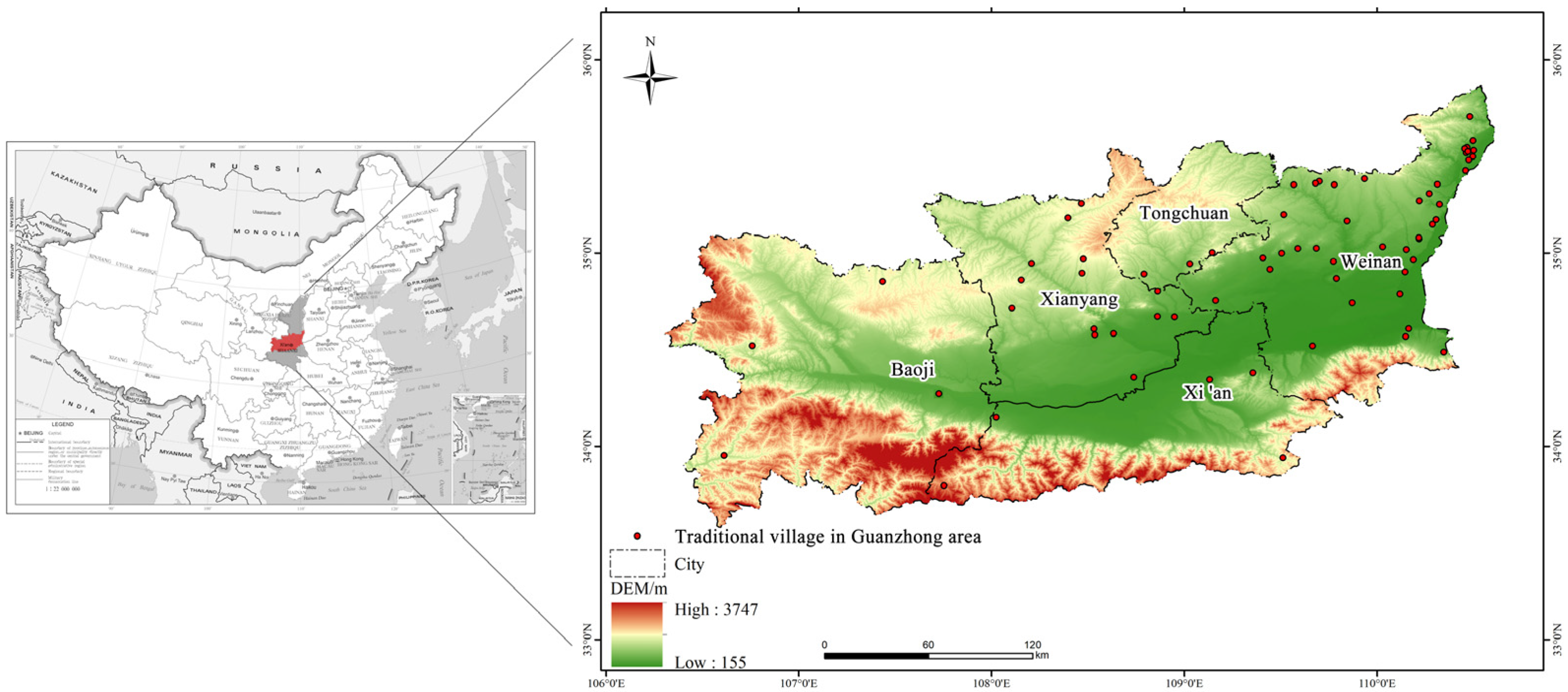
2.1. Study Area
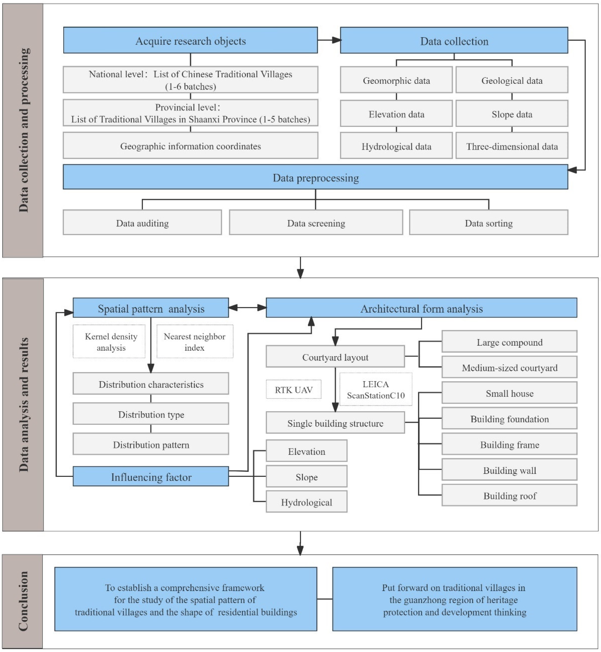
2.2. Data Acquisition and Pre-Processing
3. Methods
3.1. Kernel Density Estimation
3.2. Nearest Neighbor Analysis
3.3. Three-Dimensional Laser Scanning
4. Results
4.1. Spatial Pattern of Traditional Villages in Guanzhong Region and Its Main Influencing Factors
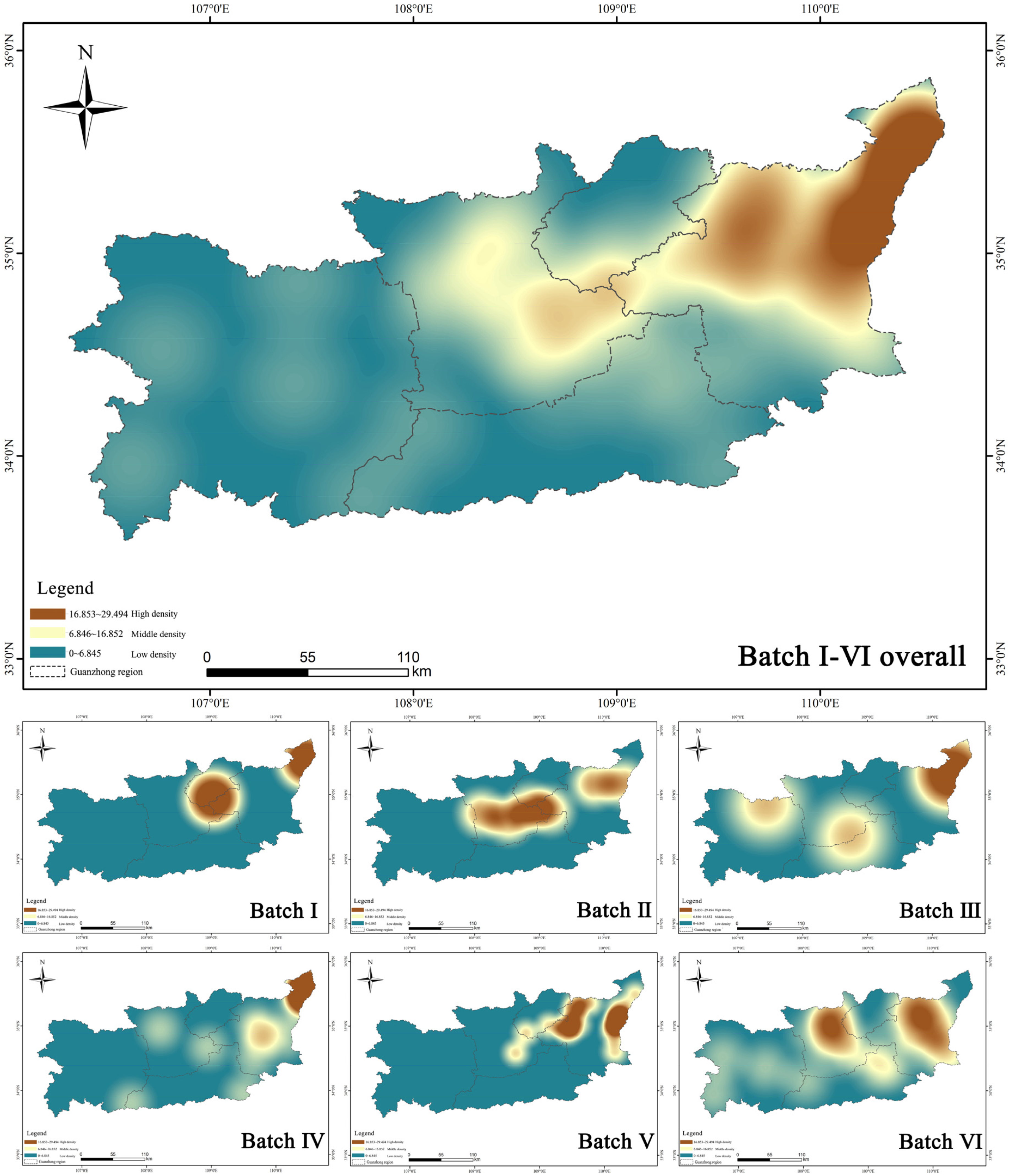
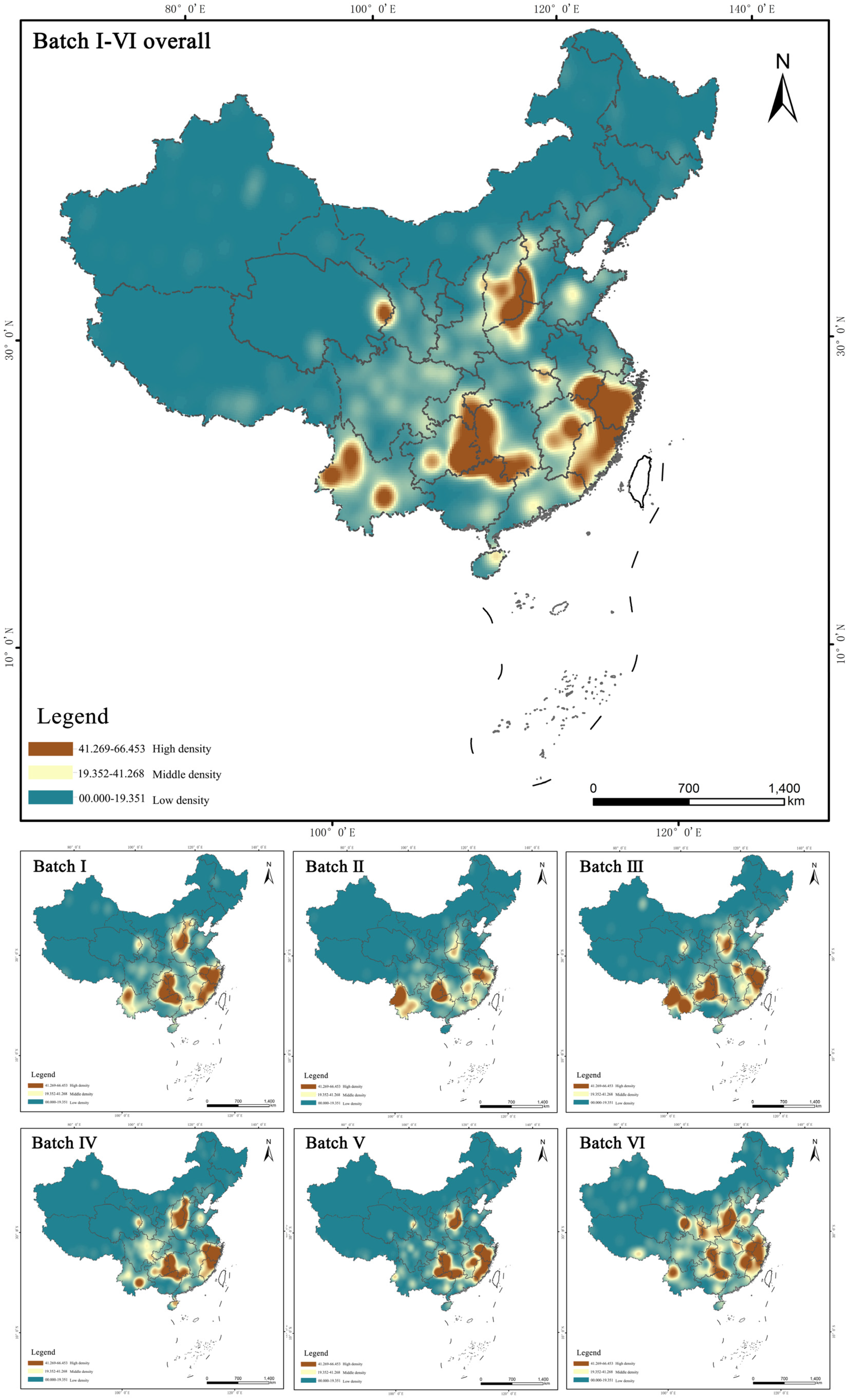
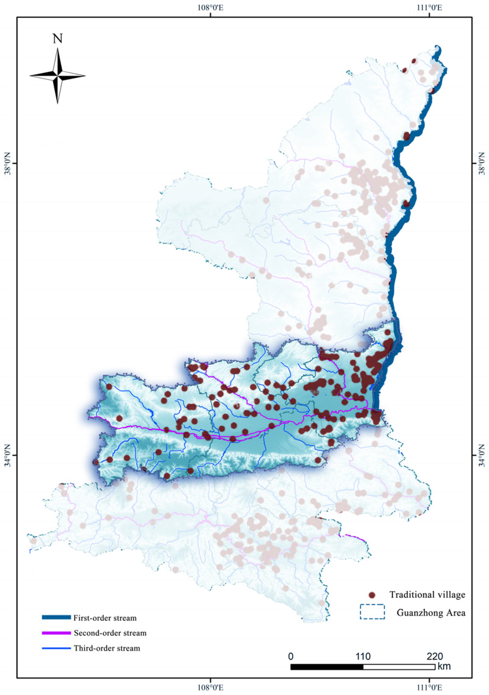
4.1.1. Spatial Distribution Characteristics
- (1)
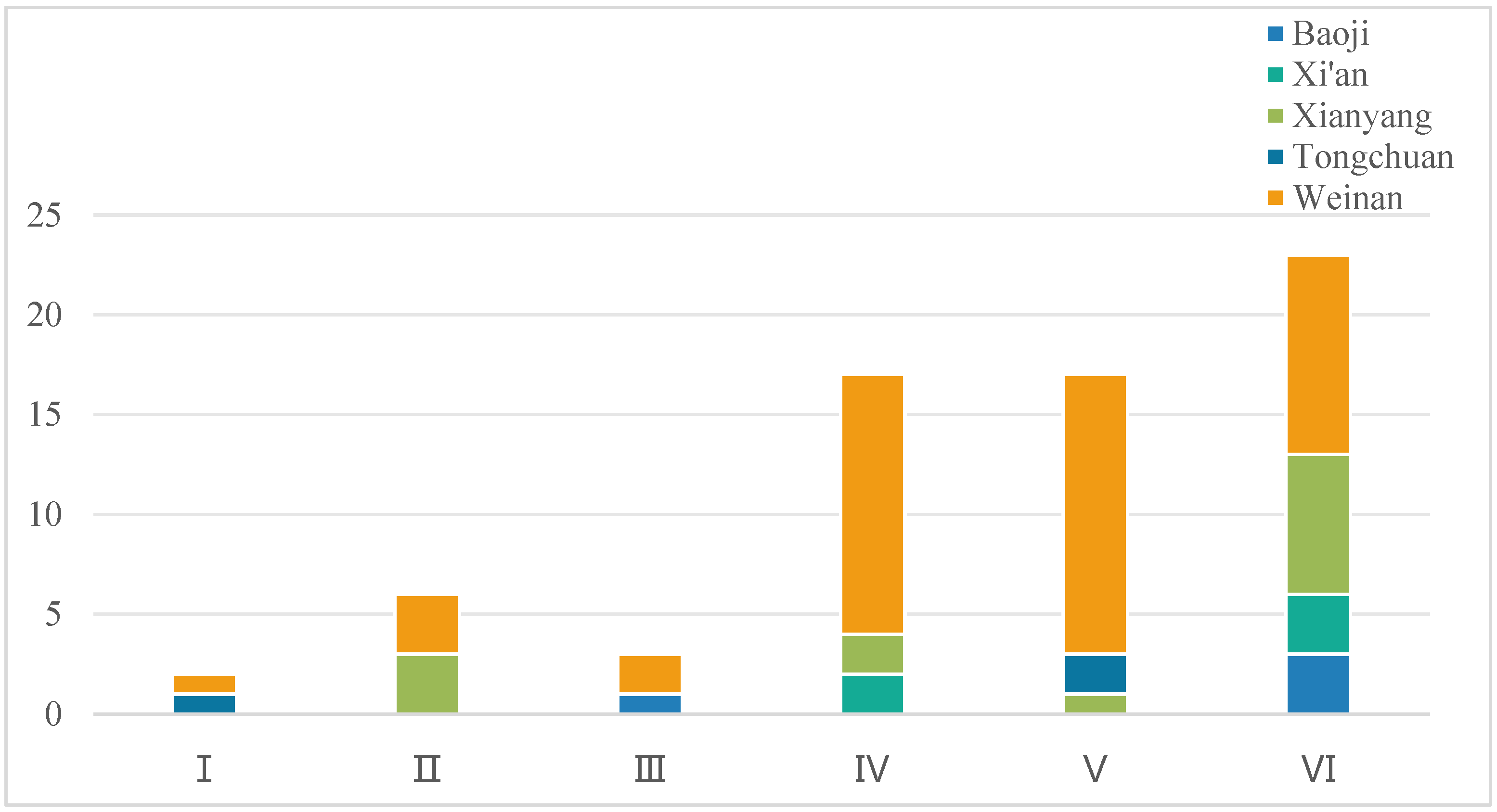
- The first batch identified two high-density core areas in the cities of Weinan and Tongchuan, representing 2.9% of the overall density in the Guanzhong region, whereas the remaining three cities exhibited the low-density distributions.
- (2)
- The second batch identified the high-density core areas in Weinan and Xianyang, representing the 8.9% of the overall density, whereas the remaining three cities continued to exhibit low-density distributions.
- (3)
- The third batch identified one high-density core area in the northeast Weinan and two medium-density areas at the junction of northern Xi’an and southern Xianyang, as well as in northern Baoji. These medium- and high-density areas represented 4.4% of the overall density, with Tongchuan continuing to exhibit low density.
- (4)
- The fourth batch demonstrated the significant growth, establishing one high-density core area in northeastern Weinan, and three medium-density areas in Baoji, Xianyang, and Xi’an. These areas accounted for 25% of the overall density, while Tongchuan remained low-density.
- (5)
- The fifth batch identified two high-density core areas in eastern and northwestern Weinan and two medium-density areas in southeastern Xianyang and southern Tongchuan. This configuration maintained an overall density of 25%, similar to that of the fourth batch but with different spatial locations. Xi’an and Baoji continued to exhibit the low-density distributions.
- (6)
- The sixth batch established two high-density core areas in central Weinan and northeastern Xianyang and two medium-density areas in northeastern Xi’an and western Baoji. These areas accounted for 33.8% of the overall density, while Tongchuan continued to exhibit a low density.
4.1.2. Spatial Distribution Types
4.1.3. Spatial Distribution Patterns
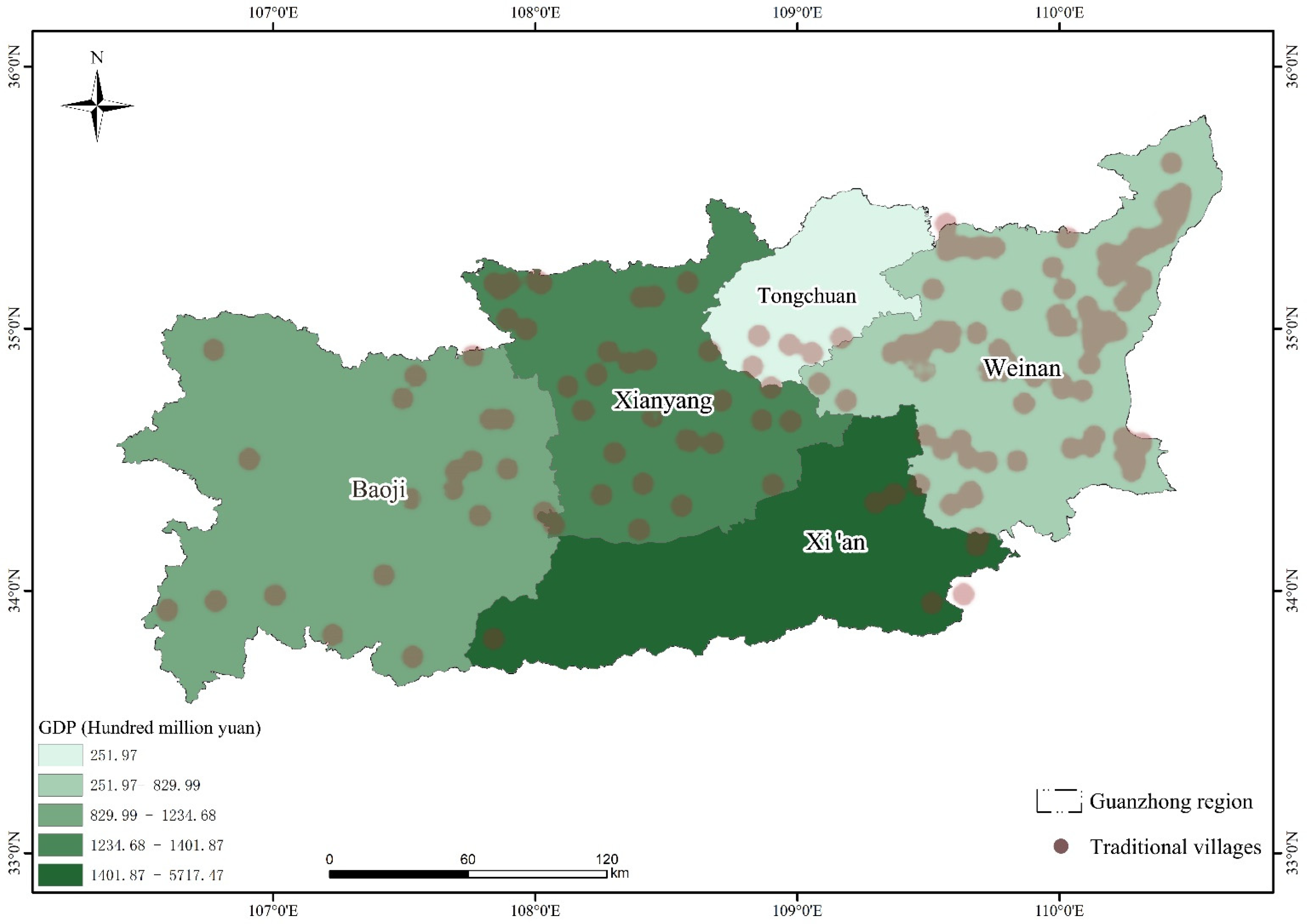
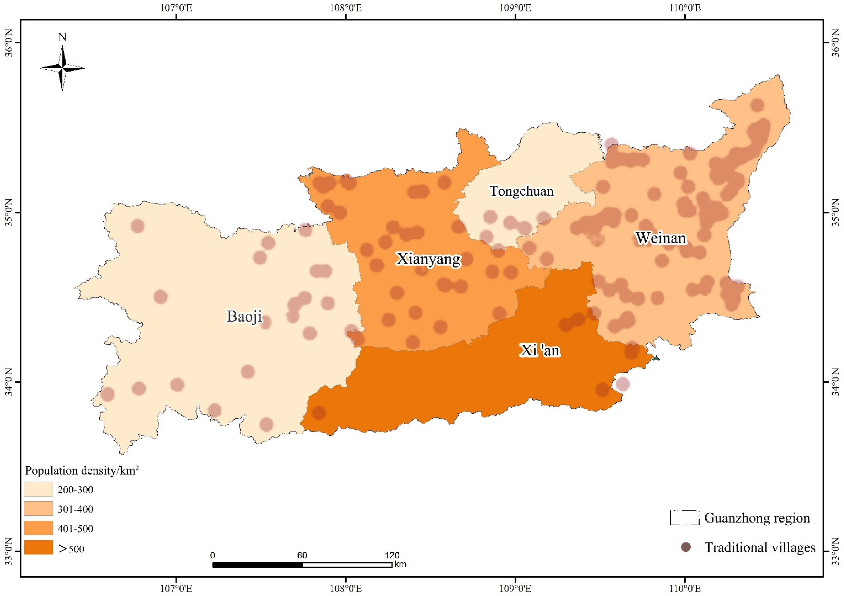
4.1.4. Main Factors Influencing Spatial Distribution
4.2. Characteristic Analysis of the Architectural Form of Residential Buildings in Guanzhong Region
4.2.1. Characteristics of the Layout of Residential Buildings
4.2.2. Structural Characteristics of Traditional Residential Buildings
- Fundamental Characteristics. The foundations of residential buildings in the Guanzhong area were influenced by soil hardness, softness, and regional climate. Because most houses were single-story, the upper load was relatively light, simplifying the foundation construction. Typically, the foundation pit was deeper, using locally sourced materials such as soil, stone, and brick. The foundations in the Guanzhong area could be broadly categorized into three types (Table 7).
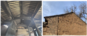
- Wooden frame characteristics. The residential buildings in the Guanzhong area were either earth or brick houses with wooden frames as the core, which functioned independently as the load-bearing structures and walls, respectively. These buildings were part of the traditional Chinese architectural construction system, and their wooden frames were primarily categorized into two forms, namely post-and-lintel construction and column-and-tie construction. The comparative analyses of these forms are detailed in Table 8.
- Wall characteristics. The Guanzhong region, characterized by low rainfall, a shallow water table, and a thick, malleable layer of loess, commonly used the loess as the building material. Although the mechanical properties of these materials could impose the limitations on the wall height and thickness, they were effectively processed to serve as strong building components. The wall characteristics of the residential buildings in the Guanzhong region were categorized into three types (Table 9).
- Roof characteristics. The roof forms of residential buildings in the Guanzhong region primarily featured the flush gable roofs, including the single-slope and double-slope designs. The single-slope roof was particularly characteristic of the area, while the small number of overhanging gable roofs were observed in the mountainous regions of Guanzhong–Qinling. Typically, roofs were constructed with the wheatgrass or reed mats as the insulating layer laid on rafters, followed by wheatgrass mud, and finished with green tiles. The main and vertical ridges could often be adorned with brick carvings to enhance their artistic appeal.
5. Discussion
5.1. Conservation of Heritage Values of Traditional Villages in Guanzhong Region
5.2. Analyzing Differences between Traditional Villages in the South and the North, with Guanzhong as the Representative of the North
5.3. Reflections on the Protection and Development of Traditional Village Heritage Values in Guanzhong Region
6. Limitations
7. Conclusions
- The spatial distribution of the six batches of traditional villages nationwide was uneven, with the density gradually decreasing from the southeast to northwest and from the southwest to northeast. This pattern formed a clustered distribution characterized by three high-density core areas and several local medium-density core areas.
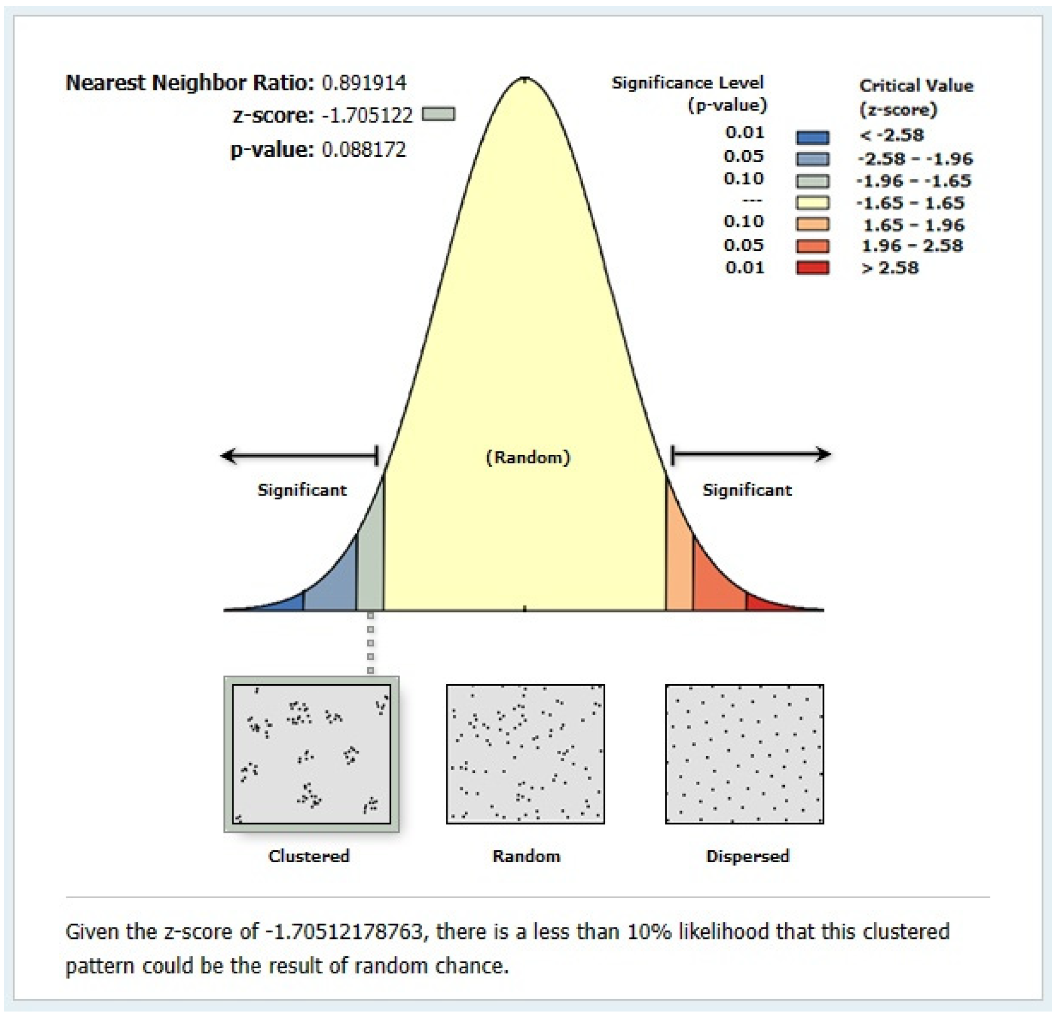
- The overall distribution of traditional villages in the Guanzhong region was clustered. However, the first, second, third, and sixth batches were discrete, whereas the fourth and fifth batches were random. The spatial distribution was imbalanced, with the high-density core areas primarily in the northeast of Weinan, the eastern part of Xianyang, and the south of Tongchuan, whereas the medium-density and low-density areas were scattered in Baoji and Xi’an. Thus, the spatial distribution pattern was characterized by a “dense east and north, sparse west, and south” configuration.
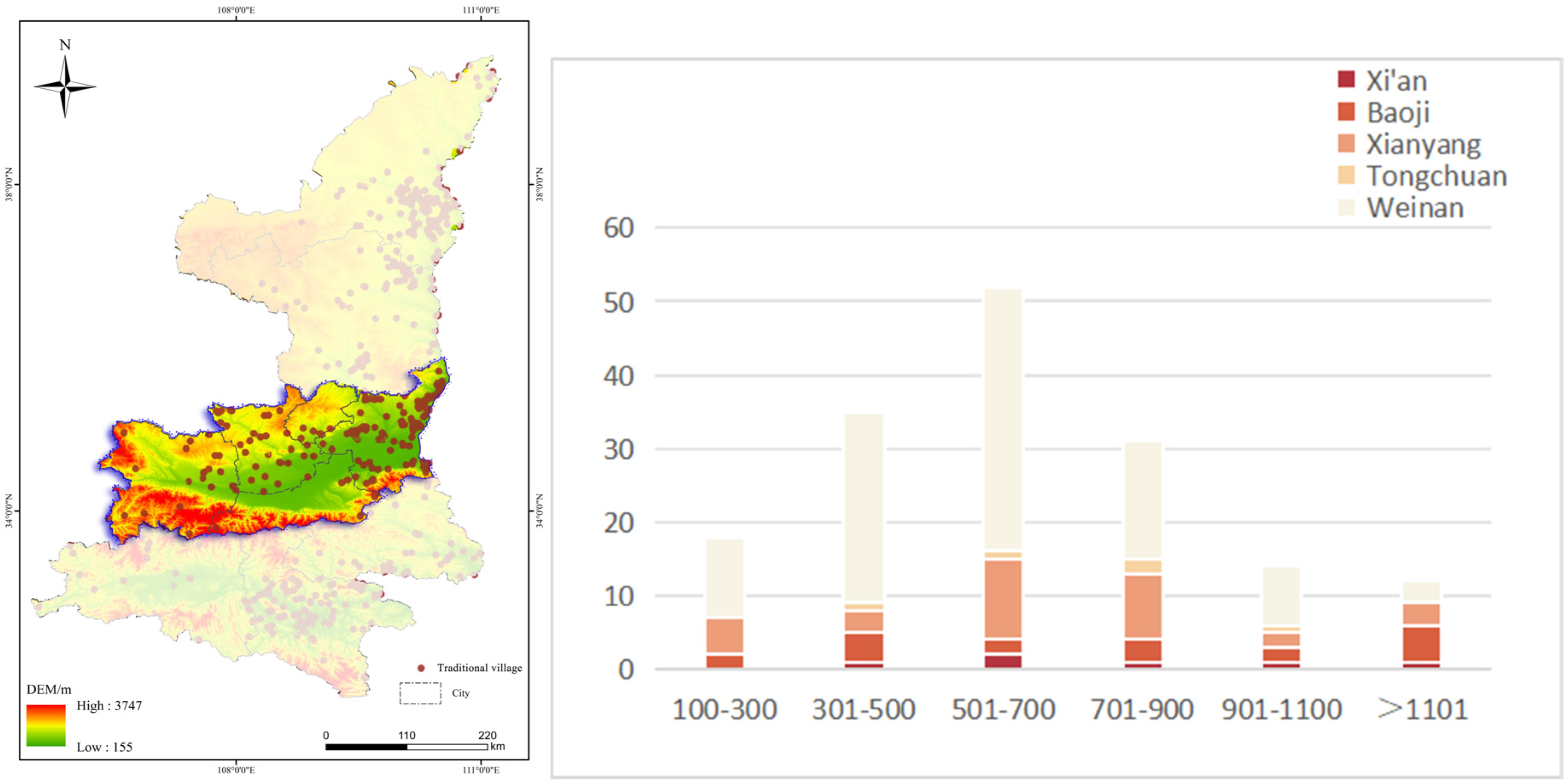
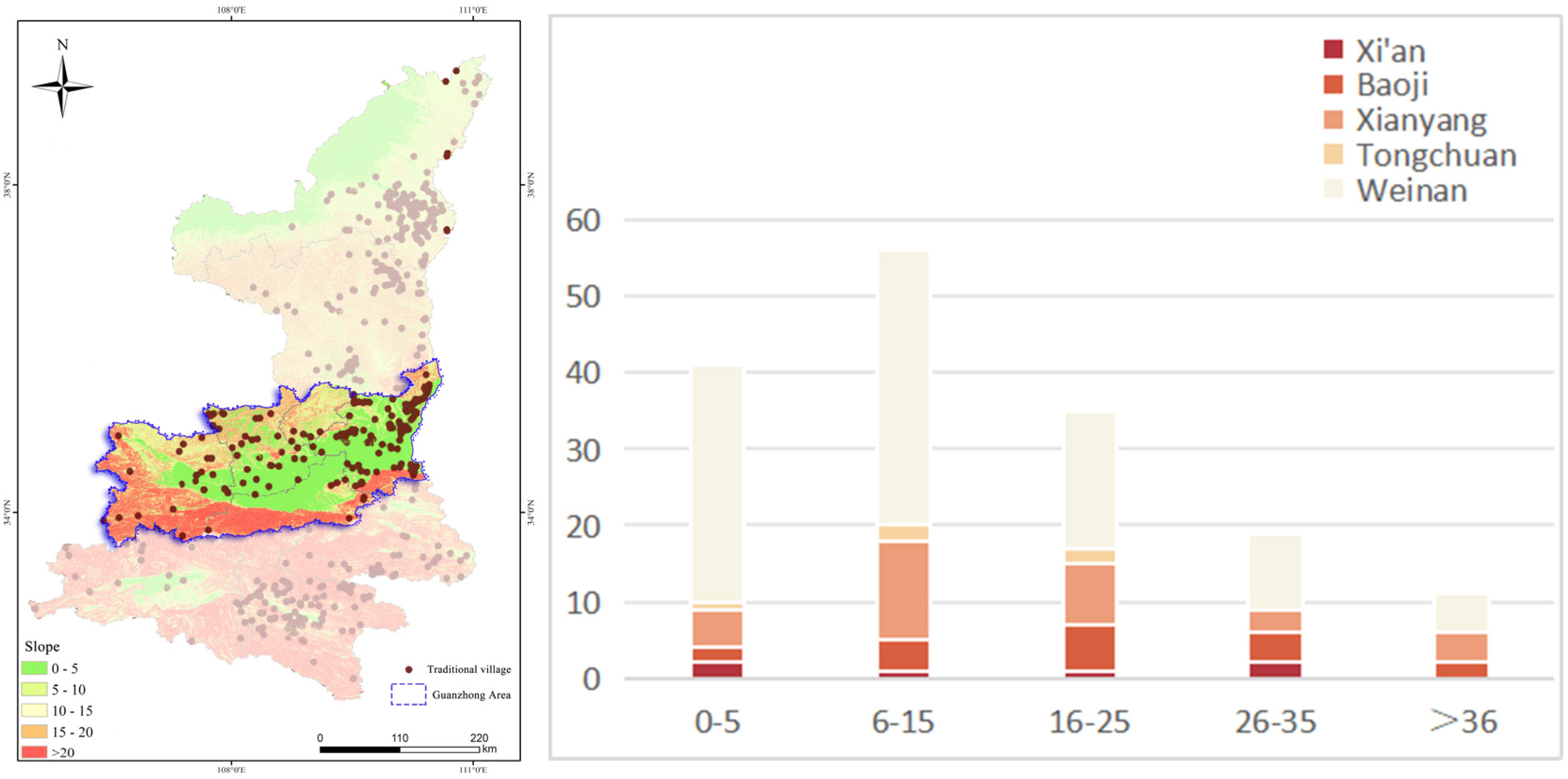
- The number of traditional villages in the Guanzhong area exhibited an inverted U-shaped trend with the increasing elevation and slope, with the majority concentrated at elevations between 501 and 700 m and slopes between 6° and 15°. These villages were primarily situated along the Yellow River Basin (Shaanxi section) and its tributaries. Consequently, the elevation, slope, and water sources were decisive factors in the spatial distribution of the traditional villages in Guanzhong.
- The architecture of the traditional villages involved two main components. The first was the “external form”, which was the spatial layout of residential buildings. This layout was characterized by rigor and regularity, vertical axis alignment, distinctive levels, narrow courtyards, and a combination of close closure and permeability within the courtyards. The layout types included the small residential buildings with a single courtyard, the medium-sized buildings with multiple vertical and horizontal courtyards, and the large buildings with crisscrossed courtyards. The second component was the “internal structure”, which referred to the single building structure of residential houses. This structure was defined by its wooden frame as the core, with various building components, such as foundations, walls, and roofs, assembled to form either civil or brick residential buildings.
Author Contributions
Funding
Institutional Review Board Statement
Informed Consent Statement
Data Availability Statement
Conflicts of Interest
References
- Fu, J.; Zhou, J.; Deng, Y. Heritage values of ancient vernacular residences in traditional villages in Western Hunan, China: Spatial patterns and influencing factors. Build. Environ. 2021, 188, 107473. [Google Scholar] [CrossRef]
- Ministry of Housing and Urban-Rural Development of the People’s Republic of China, 2012. About Conducting a Survey of Traditional Villages. Available online: https://www.mohurd.gov.cn/gongkai/zhengce/zhengcefilelib/201204/20120423_209619.html (accessed on 23 April 2012).
- Wu, K.; Su, W.; Ye, S.; Li, W.; Cao, Y.; Jia, Z. Analysis on the geographical pattern and driving force of traditional villages based on GIS and Geodetector: A case study of Guizhou, China. Sci. Rep. 2023, 13, 20659. [Google Scholar] [CrossRef] [PubMed]
- Qiu, Z.; Hu, X.; Qian, H.; Liao, K.; Huang, X.; Liu, Y.; Wei, B. Spatiotemporal Distribution Characteristics and Influencing Factors of Traditional Villages in Fujian Province. Econ. Geogr. 2023, 43, 211–219. [Google Scholar] [CrossRef]
- Liu, C.; Cao, Y.; Yang, C.; Zhou, Y.; Ai, M. Pattern identification and analysis for the traditional village using low altitude UAV-borne remote sensing: Multifeatured geospatial data to support rural landscape investigation, documentation and management. J. Cult. Herit. 2020, 44, 185–195. [Google Scholar] [CrossRef]
- Gao, W.; Zhuo, X.; Xiao, D. Spatial patterns, factors, and ethnic differences: A study on ethnic minority villages in Yunnan, China. Heliyon 2024, 10, e27677. [Google Scholar] [CrossRef]
- Bi, S.; Du, J.; Tian, Z.; Zhang, Y. Investigating the spatial distribution mechanisms of traditional villages from the human geography region: A case study of Jiangnan, China. Ecol. Inform. 2024, 81, 102649. [Google Scholar] [CrossRef]
- Wang, H.-F.; Chiou, S.-C. Research on the Sustainable Development of Traditional Dwellings. Sustainability 2019, 11, 5333. [Google Scholar] [CrossRef]
- Zhao, X.; Xue, P.; Wang, F.; Qin, Y.; Duan, X.; Yang, Z. How to become one? The modern bond of traditional villages in centralized contiguous protection and utilization areas in China. Habitat Int. 2024, 145, 103018. [Google Scholar] [CrossRef]
- Chen, L.; Zhong, Q.; Li, Z. Analysis of spatial characteristics and influence mechanism of human settlement suitability in traditional villages based on multi-scale geographically weighted regression model: A case study of Hunan province. Ecol. Indic. 2023, 154, 110828. [Google Scholar] [CrossRef]
- Ma, H.; Tong, Y. Spatial differentiation of traditional villages using ArcGIS and GeoDa: A case study of Southwest China. Ecol. Inform. 2022, 68, 101416. [Google Scholar] [CrossRef]
- Zhong, Q.; Fu, H.; Yan, J.; Li, Z. How does energy utilization affect rural sustainability development in traditional villages? Re-examination from the coupling coordination degree of atmosphere-ecology-socioeconomics system. Build. Environ. 2024, 257, 111541. [Google Scholar] [CrossRef]
- Chen, W.; Yang, L.; Wu, J.; Wu, J.; Wang, G.; Bian, J.; Zeng, J.; Liu, Z. Spatio-temporal characteristics and influencing factors of traditional villages in the Yangtze River Basin: A Geodetector model. Herit. Sci. 2023, 11, 111. [Google Scholar] [CrossRef]
- Kaur, H.; Garg, P. Urban sustainability assessment tools: A review. J. Clean. Prod. 2019, 210, 146–158. [Google Scholar] [CrossRef]
- Liu, J.; Zhang, X.; Lin, J.; Li, Y. Beyond government-led or community-based: Exploring the governance structure and operating models for reconstructing China’s hollowed villages. J. Rural Stud. 2022, 93, 273–286. [Google Scholar] [CrossRef]
- Chen, Z.; Yang, H.; Lin, Y.; Xie, J.; Xie, Y.; Ding, Z. Exploring the association between the built environment and positive sentiments of tourists in traditional villages in Fuzhou, China. Ecol. Inform. 2024, 80, 102465. [Google Scholar] [CrossRef]
- Hou, X.; Cheng, B.; Yang, J. A quantitative study on the exterior wall texture of stone-built dwellings in traditional villages in China: A case study of the xisuo village in the Jiarong Tibetan area. J. Build. Eng. 2021, 42, 102357. [Google Scholar] [CrossRef]
- Ruggiero, G.; Parlavecchia, M.; Sasso, P.D. Typological characterisation and territorial distribution of traditional rural buildings in the Apulian territory (Italy). J. Cult. Herit. 2019, 39, 278–287. [Google Scholar] [CrossRef]
- Zhou, W.; Fu, X.; Deng, Y.; Yan, J.; Zhou, J.; Liu, P. The Extraction of Roof Feature Lines of Traditional Chinese Village Buildings Based on UAV Dense Matching Point Clouds. Buildings 2024, 14, 1180. [Google Scholar] [CrossRef]
- Li, X.; Yang, Q.; Lyu, X.; Ye, Y.; Zhang, B. Multidimensional framework for analyzing the distribution patterns of traditional villages in the karst landscape regions of China. Ecol. Inform. 2023, 77, 102184. [Google Scholar] [CrossRef]
- Wang, W.; Shi, Q.; Wang, G. Analysis of Performance and Genetic Characteristics of Cultural Landscapes in Traditional Villages along the Jinzhong Section of the Wanli Tea Road from a Landscape Gene Information Chain Perspective: A Case Study of Xiamen Village. Sustainability 2024, 16, 8131. [Google Scholar] [CrossRef]
- Zeng, C.; Liu, P.; Huang, L.; Feng, S.; Li, Y. Features of architectural landscape fragmentation in traditional villages in Western Hunan, China. Sci. Rep. 2023, 13, 18633. [Google Scholar] [CrossRef] [PubMed]
- Zheng, W.; Li, B.; Liu, P.; Zeng, R.; Deng, Y.; Zeng, C. Gene identification and Zoning of traditional village landscape groups in Hunan Province. Econ. Geogr. 2021, 41, 204–212. [Google Scholar] [CrossRef]
- Yanan, L.; Ismail, M.A.; Aminuddin, A. How has rural tourism influenced the sustainable development of traditional villages? A systematic literature review. Heliyon 2024, 10, e25627. [Google Scholar] [CrossRef] [PubMed]
- Tang, C.; Yang, Y.; Liu, Y.; Xiao, X. Comprehensive evaluation of the cultural inheritance level of tourism-oriented traditional villages: The example of Beijing. Tour. Manag. Perspect. 2023, 48, 101166. [Google Scholar] [CrossRef]
- Liu, S.; Ge, J.; Bai, M.; Yao, M.; He, L.; Chen, M. Toward classification-based sustainable revitalization: Assessing the vitality of traditional villages. Land Use Policy 2022, 116, 106060. [Google Scholar] [CrossRef]
- Yang, R.; Xu, Q.; Long, H. Spatial distribution characteristics and optimized reconstruction analysis of China’s rural settlements during the process of rapid urbanization. J. Rural Stud. 2016, 47, 413–424. [Google Scholar] [CrossRef]
- Li, Y.; Fan, W.; Yuan, X.; Li, J. Spatial distribution characteristics and influencing factors of traditional villages based on geodetector: Jiarong Tibetan in Western Sichuan, China. Sci. Rep. 2024, 14, 11700. [Google Scholar] [CrossRef]
- Chen, J.; Wang, S.; Zou, Y. Construction of an ecological security pattern based on ecosystem sensitivity and the importance of ecological services: A case study of the Guanzhong Plain urban agglomeration, China. Ecol. Indic. 2022, 136, 108688. [Google Scholar] [CrossRef]
- Xiong, Y.; Zhang, J.; Yan, Y.; Sun, S.; Xu, X.; Higueras, E. Effect of the spatial form of Jiangnan traditional villages on microclimate and human comfort. Sustain. Cities Soc. 2022, 87, 104136. [Google Scholar] [CrossRef]
- Wang, S.; Wang, Y.; Liu, H.; Gao, H.; Chen, L. Research on ecological energy saving measures of traditional village buildings in the South of Henan Province. Ind. Constr. 2018, 48, 61–65. [Google Scholar] [CrossRef]
- Zhang, J.; Zhang, R.; Li, Q.; Zhang, X.; He, X. Spatial Sifferentiation and Differentiated Development Paths of Traditional Villages in Yunnan Province. Land 2023, 12, 1663. [Google Scholar] [CrossRef]
- Lu, S.; Zhang, X.; Zhang, Y. Spatial-temporal distribution and controlling factors of traditional villages in Huizhou Region. Sci. Geogr. Sin. 2018, 38, 1690–1698. [Google Scholar] [CrossRef]
- Liu, W.; Xue, Y.; Shang, C. Spatial distribution analysis and driving factors of traditional villages in Henan province: A comprehensive approach via geospatial techniques and statistical models. Herit. Sci. 2023, 11, 185. [Google Scholar] [CrossRef]
- Li, R.; Shi, Z. Spatial relationship and formation mechanism of traditional villages and intangible cultural heritage in the Yellow River Basin. Econ. Geogr. 2022, 42, 205–212. [Google Scholar] [CrossRef]
- Huang, Z.M.; Liang, Y.M. Digital protection and inheritance of ancient villages in southwest minority areas under the strategy of rural revitalization. Technol. Forecast. Soc. Change 2020, 160, 120238. [Google Scholar] [CrossRef]
- Mu, Q.; Aimar, F. How Are Historical Villages Changed? A Systematic Literature Review on European and Chinese Cultural Heritage Preservation Practices in Rural Areas. Land 2022, 11, 982. [Google Scholar] [CrossRef]
- Tao, W.; Chen, H.; Lin, J. Spatial form and spatial cognition of traditional village in syntactical view: A case study of Xiaozhou Village, Guangzhou. Acta Geogr. Sin. 2013, 68, 209–218. [Google Scholar]
- Fang, Q.; Li, Z. Cultural ecology cognition and heritage value of huizhou traditional villages. Heliyon 2022, 8, e12627. [Google Scholar] [CrossRef]
- He, Y.; Zhang, T.; Xiong, D. Evaluation on cultural value of traditional villages and differential revitalization: A case study of Jiaozuo City, Henan Province. Econ. Geogr. 2020, 40, 230–239. [Google Scholar] [CrossRef]
- Nie, Z.; Li, N.; Pan, W.; Yang, Y.; Chen, W.; Hong, C. Quantitative Research on the Form of Traditional Villages Based on the Space Gene—A Case Study of Shibadong Village in Western Hunan, China. Sustainability 2022, 14, 8965. [Google Scholar] [CrossRef]
- Zhao, P.; Wu, L.; Li, Y. Analysis of the form characteristics of traditional dwellings in the Tongchuan area of Shaanxi Province, China. J. Asian Arch. Build. Eng. 2023, 1–18. [Google Scholar] [CrossRef]
- Hu, Q.; Wang, S.; Fu, C.; Ai, M.; Yu, D.; Wang, W. Fine Surveying and 3D Modeling Approach for Wooden Ancient Architecture via Multiple Laser Scanner Integration. Remote. Sens. 2016, 8, 270. [Google Scholar] [CrossRef]
- Wang, Q.; Liu, W.; Mao, L. Spatial Evolution of Traditional Village Dwellings in Heilongjiang Province. Sustainability 2023, 15, 5330. [Google Scholar] [CrossRef]
- Li, Y.; Lian, M. Analysis on the layout of traditional residential courtyards and building structures in Guanzhong Area, Shaanxi—Taking Xiaojiapo Village in Lantian County as an example. In Proceedings of the 2021 6th International Conference on Minerals Source, Geotechnology and Civil Engineering, Guangzhou, China, 9–11 April 2021; p. 012141. [Google Scholar]
- Huang, H.; Miao, H.; Li, S.; Wang, Y. Spatial pattern and influence mechanism of traditional villages in Northwest China. Econ. Geogr. 2021, 41, 233–240. [Google Scholar] [CrossRef]
- Zheng, X.; Wu, J.; Deng, H. Spatial Distribution and Land Use of Traditional Villages in Southwest China. Sustainability 2021, 13, 6326. [Google Scholar] [CrossRef]
- Kong, L.; Lu, D.; Ye, F. Application of 3D laser scanning technology in historic building facade surveying and mapping. Bull. Surv. Mapp. 2022, 172, 165–168. [Google Scholar] [CrossRef]
- Wang, W.; Hei, M.; Peng, F.; Li, J.; Chen, S.; Huang, Y.; Feng, Z. Development of “air-ground data fusion” based LiDAR method: Towards sustainable preservation and utilization of multiple-scaled historical blocks and buildings. Sustain. Cities Soc. 2023, 91, 104414. [Google Scholar] [CrossRef]
- Chen, X.; Xie, W.; Li, H. The spatial evolution process, characteristics and driving factors of traditional villages from the perspective of the cultural ecosystem: A case study of Chengkan Village. Habitat Int. 2020, 104, 102250. [Google Scholar] [CrossRef]
- Li, N.; Zhang, F.; Geng, W.; Li, Z. Research on performance improvement design strategies for urban historic districts and suburban traditional villages in multiple scopes. J. Build. Eng. 2023, 72, 106342. [Google Scholar] [CrossRef]
- Liu, P.; Zeng, C.; Liu, R. Environmental adaptation of traditional Chinese settlement patterns and its landscape gene mapping. Habitat Int. 2023, 135, 102808. [Google Scholar] [CrossRef]
- Wang, D.; Wei, X.; Yan, X.; Sohaib, O. A Study on Sustainable Design of Traditional Tujia Village Architecture in Southwest Hubei, China. Buildings 2024, 14, 128. [Google Scholar] [CrossRef]
- Wang, D.; Lyu, Q.; Wu, Y.; Fan, Z. The characteristic of regional differentiation and impact mechanism of architecture style of traditional residence. J. Nat. Resour. 2019, 34, 1864–1885. [Google Scholar] [CrossRef]
- Palupi, S.; Hardiilla, D.; Nugroho, A.C. Vernacular architecture: Typology, heritage, and cultural tourism. In Proceedings of the 5th International Conference on Indonesian Architecture and Planning (ICIAP), Yogyakarta, Indonesia, 15–16 October 2020; p. 012011. [Google Scholar]
- Bai, Y.; Gao, J.; Pitts, A.; Gao, Y.; Bai, W.; Tao, Z. Improving the Sustainability of Traditional Dwellings in Yunnan, China: Seismic Resistance Testing of Wood-frame and Earth-Built Wall Dwellings. Sustainability 2019, 11, 977. [Google Scholar] [CrossRef]
- Zhou, Q. Research on Traditional Reinforcement Techniques for Rammed Earth Walls in China. Int. J. Arch. Herit. 2024, 1–19. [Google Scholar] [CrossRef]
- Liu, X.; Li, Y.; Wu, Y.; Li, C. The Spatial Pedigree in Traditional Villages under the Perspective of Urban Regeneration—Taking 728 Villages in Jiangnan Region, China as Cases. Land 2022, 11, 1561. [Google Scholar] [CrossRef]
- Gao, J.; Wu, B. Revitalizing traditional villages through rural tourism: A case study of Yuanjia Village, Shaanxi Province, China. Tour. Manag. 2017, 63, 223–233. [Google Scholar] [CrossRef]
- Feng, X.; Hu, M.; Somenahalli, S.; Bian, X.; Li, M.; Zhou, Z.; Li, F.; Wang, Y. A Study of Spatio-Temporal Differentiation Characteristics and Driving Factors of Shaanxi Province’s Traditional Heritage Villages. Sustainability 2023, 15, 7797. [Google Scholar] [CrossRef]
- Liu, P. The theory and practice exploration of “remembering nostalgia” in the construction of new urbanization. Geogr. Res. 2015, 34, 1205–1212. [Google Scholar]

| Province | First Batch | Second Batch | Third Batch | Fourth Batch | Fifth Batch | Sixth Batch | Total | Percentage | Area | Count Density |
|---|---|---|---|---|---|---|---|---|---|---|
| Yunnan | 62 | 232 | 208 | 113 | 93 | 69 | 777 | 9.53% | 39.40 | 19.72 |
| Guizhou | 90 | 202 | 134 | 119 | 179 | 33 | 757 | 9.28% | 17.60 | 43.01 |
| Hunan | 30 | 42 | 19 | 166 | 401 | 46 | 704 | 8.63% | 21.18 | 33.24 |
| Zhejiang | 43 | 47 | 86 | 225 | 235 | 65 | 701 | 8.60% | 10.18 | 68.86 |
| Shanxi | 48 | 22 | 59 | 150 | 271 | 69 | 619 | 7.59% | 16.64 | 37.20 |
| Fujian | 48 | 25 | 52 | 104 | 265 | 58 | 552 | 6.77% | 12.00 | 46.00 |
| Anhui | 25 | 40 | 46 | 52 | 237 | 70 | 470 | 5.76% | 13.96 | 33.67 |
| Jiangxi | 33 | 56 | 36 | 50 | 168 | 70 | 413 | 5.06% | 16.69 | 24.75 |
| Sichuan | 20 | 42 | 22 | 141 | 108 | 63 | 396 | 4.86% | 48.61 | 8.15 |
| Guangxi | 39 | 30 | 20 | 72 | 119 | 62 | 342 | 4.19% | 23.67 | 14.45 |
| Guangdong | 40 | 51 | 35 | 34 | 103 | 29 | 292 | 3.58% | 17.98 | 16.24 |
| Hebei | 32 | 7 | 18 | 88 | 61 | 70 | 276 | 3.38% | 18.80 | 14.68 |
| Henan | 16 | 46 | 37 | 25 | 81 | 70 | 275 | 3.37% | 16.70 | 16.47 |
| Hubei | 28 | 15 | 46 | 29 | 88 | 64 | 270 | 3.31% | 18.59 | 14.52 |
| Qinghai | 13 | 7 | 21 | 38 | 44 | 60 | 183 | 2.24% | 72.23 | 2.53 |
| Shaanxi | 5 | 8 | 17 | 41 | 42 | 66 | 179 | 2.19% | 20.58 | 8.70 |
| Shandong | 10 | 6 | 21 | 38 | 50 | 43 | 168 | 2.06% | 15.71 | 10.69 |
| Chongqing | 14 | 2 | 47 | 11 | 36 | 54 | 164 | 2.01% | 8.23 | 19.93 |
| Gansu | 7 | 6 | 2 | 21 | 18 | 54 | 108 | 1.32% | 42.58 | 2.54 |
| Tibet | 5 | 1 | 5 | 8 | 16 | 45 | 80 | 0.98% | 122.84 | 0.65 |
| Jiangsu | 3 | 13 | 10 | 2 | 5 | 46 | 79 | 0.97% | 10.26 | 7.70 |
| Hainan | 7 | 0 | 12 | 28 | 17 | 12 | 76 | 0.93% | 3.51 | 21.65 |
| Inner Mongolia | 3 | 5 | 16 | 20 | 2 | 16 | 62 | 0.76% | 118.30 | 0.52 |
| Xinjiang | 4 | 3 | 8 | 2 | 1 | 35 | 53 | 0.65% | 166.49 | 0.32 |
| Liaoning | 0 | 0 | 8 | 9 | 13 | 15 | 45 | 0.55% | 14.80 | 3.04 |
| Beijing | 9 | 4 | 3 | 5 | 1 | 4 | 26 | 0.32% | 1.64 | 15.85 |
| Heilongjiang | 2 | 1 | 2 | 1 | 8 | 12 | 26 | 0.32% | 47.30 | 0.55 |
| Ningxia | 4 | 0 | 0 | 1 | 1 | 20 | 26 | 0.32% | 6.64 | 3.92 |
| Jilin | 0 | 2 | 4 | 3 | 2 | 12 | 23 | 0.28% | 18.74 | 1.23 |
| Tianjin | 1 | 0 | 0 | 2 | 1 | 4 | 8 | 0.10% | 1.19 | 6.72 |
| Shanghai | 5 | 0 | 0 | 0 | 0 | 0 | 5 | 0.06% | 0.64 | 7.81 |
| Total | 646 | 915 | 994 | 1598 | 2666 | 1336 | 8155 | 100% | 963.68 |
| Area | City | First Batch | Second Batch | Third Batch | Fourth Batch | Total | Proportion | Regional Area | Density | ||||
|---|---|---|---|---|---|---|---|---|---|---|---|---|---|
| Guanzhong | Xi’an | 1 | 1 | 0 | 4 | 6 | 162 | 33.47% | 3.70% | 5.55 | 1.08 | 29.14 | 5.56 |
| Baoji | 10 | 1 | 4 | 3 | 18 | 11.11% | 1.81 | 9.94 | |||||
| Xianyang | 14 | 11 | 2 | 6 | 33 | 20.37% | 1.02 | 32.35 | |||||
| Tongchuan | 1 | 0 | 4 | 0 | 5 | 3.09% | 0.34 | 14.71 | |||||
| Weinan | 28 | 36 | 21 | 15 | 100 | 61.73% | 1.30 | 76.92 | |||||
| Shanbei | Yan’an | 16 | 17 | 33 | 6 | 72 | 179 | 36.98% | 40.22% | 8.43 | 3.7 | 19.35 | 19.46 |
| Yulin | 40 | 37 | 20 | 10 | 107 | 59.78% | 4.73 | 22.62 | |||||
| Shannan | Hanzhong | 5 | 6 | 7 | 1 | 19 | 143 | 29.54% | 13.29% | 6.58 | 2.72 | 19.32 | 6.99 |
| Ankang | 40 | 39 | 6 | 3 | 88 | 61.54% | 2.35 | 37.45 | |||||
| Shangluo | 16 | 4 | 9 | 7 | 36 | 25.17% | 1.51 | 23.84 | |||||
| Total | 171 | 152 | 106 | 55 | 484 | 100% | 20.56 | ||||||
| Batch | Do | De | ANN | Z-Value | p-Value | Distribution Type |
|---|---|---|---|---|---|---|
| First Batch | 92.6 | 51.9 | 1.785 | 3.539 | 0.000 | Discrete |
| Second Batch | 36.4 | 14.7 | 2.482 | 6.944 | 0.000 | Discrete |
| Third Batch | 92.3 | 10.1 | 9.158 | 27.030 | 0.000 | Discrete |
| Fourth Batch | 30.3 | 25.6 | 1.187 | 1.475 | 0.140 | Random |
| Fifth Batch | 17.4 | 15.4 | 1.128 | 1.008 | 0.313 | Random |
| Sixth Batch | 25.9 | 20.7 | 1.247 | 2.267 | 0.023 | Discrete |
| Comparative Analysis | Analyzed Object | Analyzed Content | ||
|---|---|---|---|---|
| Spatial distribution patterns | Regiment | Belt | Point | The regiment pattern, most prevalent in Guanzhong, was primarily found in open alluvial plains and loess plateau areas, featuring a regular layout with clear traffic routes and systematic horizontal and vertical arrangements with the role of the cold wind. The belt pattern was commonly located along transport routes and riverbanks, where villages extended and developed along the main roads and rivers, thus facilitating the accessibility and the living conditions. The point patterns were generally observed in mountainous and loess regions, where the terrain and geomorphological constraints prevented grouping, and the villages were situated to utilize elevation differences to protect against wind and cold. |
 |  |  | ||
| Skeleton system (Meso-analysis) | Entrance space | Street space | Public activity space | The entrance spaces of traditional villages are shaped by geological features, natural resources, and transportation access. In the Guanzhong Plain, villages on major transportation routes often have multiple entrances, while those with unique terrain or limited access typically have single entrances with prominent gates or pagodas. In mountainous areas, entrances are more scattered, lacking distinct markers. Street space is the internal skeleton of traditional village spatial layout pattern, linking residential buildings and influencing their arrangement. In Guanzhong, common street patterns include linear, intersecting, and "T" shapes, adapted to the village’s topography, landform, and layout. The width, length, and direction of these streets are influenced by planning, architectural styles, and historical and cultural factors. Public spaces support daily life, social interactions, cultural heritage, and economic activities. In Guanzhong, these include agricultural production spaces, communal areas for socializing and recreation, religious spaces for temples and ancestral halls, and commercial areas for trading and economic activities. |
 | 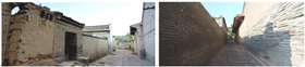 |  | ||
| Residential buildings (Micro-analysis) | Fundamental | Wooden frame Wall | Roof | A number of building components such as foundation, Wooden frame, wall and roof are combined to form a residential building, which is analyzed in detail in Section 4.2 “Characteristic analysis of the architectural form of residential buildings in Guanzhong region” |
 |  |  | ||
| City | Economic Factor | Traffic Factor | Demographic Factor | |||||
|---|---|---|---|---|---|---|---|---|
| GDP/100 Million Yuan | GDP Growth Rate/% | Total GDP Ranking | Number of Traditional Villages | Road Mileage/km | Road Density | Population Number/10,000 | Population Density/km2 | |
| Xi’an | 5717.47 | 5.20% | 1 | 6 | 13,386 | 132.43 | 1307.82 | 1293 |
| Baoji | 1234.68 | 3.30% | 3 | 18 | 17,003 | 93.85 | 326.47 | 179 |
| Xianyang | 1401.87 | 4.35% | 2 | 33 | 17,038 | 166.28 | 412.10 | 401 |
| Tongchuan | 251.97 | 4.30% | 5 | 5 | 4143 | 106.73 | 70.50 | 180 |
| Weinan | 829.99 | 4.04% | 4 | 100 | 19,897 | 151.49 | 461.90 | 354 |
| Courtyard Type | Name of the Courtyard | Plane Layout | Current Photo | Courtyard Features |
|---|---|---|---|---|
| Large courtyard | The Yao family compound, Beilin district | 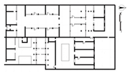 |  | Yao family compound in Ludang, Beilin district, Xi’an ■ One of the few remaining large-scale compounds from the Ming and Qing dynasties in the Guanzhong area. ■ Composed of several single-court dwellings arranged longitudinally. ■ The courtyard is situated along the transverse side, adding auxiliary space to the overall courtyard design. ■ The layout is as follows: the main courtyard features three entries with five-room divisions, while the side courtyard has three entries with three-room divisions. |
| The Zhou family compound, Sanyuan county | 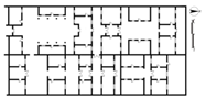 |  | Zhou family compound in Sanyuan County, Xi’an ■ The Zhou family compound was originally a large-scale settlement with 17 courtyards, but only 1 courtyard remains. ■ The existing courtyard has a total depth of 71 m and a width of 45 m. It is also divided into the main courtyard and side courtyard. ■ The layout is as follows: the courtyard is situated south facing north and features three-entry, five-room divisions consisting of two courtyards arranged horizontally. | |
| The Liu family compound, Qianyang county | 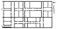 | 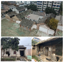 | Liu family compound in Qianyang County, Baoji ■ One of the relatively complete large mansions from the Ming and Qing Dynasties in Baoji. ■ The courtyard is situated north facing south, with a total depth of 71 m and a width of 45 m. ■ Due to time and other factors, the remains of the current side courtyard are intact and still in use, while only the entrance hall of the main courtyard has been preserved. ■ The layout features three-entry and three-room divisions. | |
| Medium-sized courtyard | The No. 76 residential house, Xiaojiapo village | 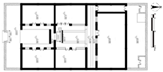 | 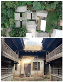 | No. 76 residential house, Xiaojiapo village, Lantian county, Xi’an ■The courtyard follows a common layout for small- and medium-sized courtyards in the Guanzhong area, with a narrow and long shape, a depth of approximately 25 m, and a width of approximately 15 m. ■ The left- and right-wing rooms are at two levels, forming an eaves space, and the north side of the main house has a corridor of approximately 1.3 m, leading to the backyard. ■ The layout of the courtyard is as follows: quadrangle dwellings with two-entry and two-room divisions. |
| The Liu family residence, Wangqiao village | 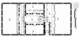 | 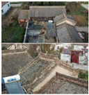 | Liu family residence in Wangqiao village, Jingyang county, Xianyang ■ This residence covers a larger area than traditional courtyards, with a depth of 40 m and a width of 32 m. ■ The entrance is located on the east side of the courtyard, differing significantly from the street-facing entrance of traditional quadrangle dwellings. ■ The layout features quadrangular dwellings with two-entry and two-room divisions. | |
| Small courtyard | The Sun family residence, Lingquan village | 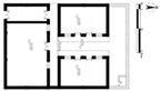 | 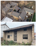 | Sun residence in Lingquan village, Heyang county, Weinan ■ The courtyard is enclosed by three single buildings: two wing rooms and one street room. With a depth of 20 m and a width of 17 m, this layout efficiently conserves the land area. ■ The two wing rooms share gables with left and right courtyards. ■ The layout features a three-section (three-enclosure) courtyard. |
| The No. 53 residential house, Qibao village | 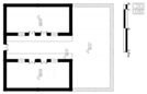 | 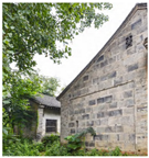 | No. 53 residence, Qibao village, Yaozhou district, Tongchuan ■ The courtyard consists solely of left- and right-wing rooms, a common architectural form in the Guanzhong Terrace area. It has a depth of approximately 15 m and a width of approximately 10 m. ■ The original main housing area is now used as a farming field. ■ The layout features a two-section (two-enclosure) courtyard. |
| Foundation Category | Pictures of Current Status | Internal Construction | Characteristics Description |
|---|---|---|---|
| Rammed earth foundation |  |  | According to the literature, in the Imperial City of Chang’an during the Tang Dynasty, rammed earth technology was employed in the foundation construction of palace walls and inner-city neighborhoods. A few rammed-earth dwellings still remain. In traditional villages, some higher-grade dwellings use a mix of crushed stone and loess to compact the foundation from the base to the top of the wall, thereby enhancing the stability of the structure. |
| Stone foundation |  |  | Because of rainfall, hard stones are often used to build foundations in some areas. This practice effectively prevents uneven settlement of the dwellings caused by water and dampness, reducing the risk of cracks, tilting, or even collapse of the walls. |
| Brick foundation |  |  | Some dwellings use bricks or strips of stone in their foundation construction, where the foundation is typically widened, and the masonry is staggered to create three to five layers of bricks above the outdoor floor. This method effectively protects against moisture and rain. |
| Construction Forms | Specific Classification | Plane Layout | Current Photo | Characteristics of Construction |
|---|---|---|---|---|
| Post-and-lintel construction | 3-Purlin Beam | 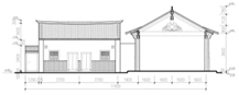 | 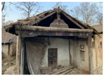 | ■ The 3-Purlin Beam is the most commonly used architectural framework in Guanzhong residential buildings. ■ Increasing the size of the bracket directly replaces the ridged column to support the edged purlin. |
| 4-Purlin Beam | 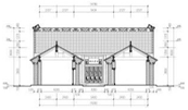 | 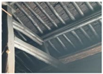 | ■ The 4-Purlin Beam is based on a frame of three beams. ■ Owing to the short length of the rafters, a Tong Column is added to one side of the wooden frame to support the cloud beam and waist purlin, thus supporting short rafters that are insufficient in length. | |
| 5-Purlin Beam | 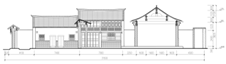 | 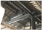 | ■ The 5-Purlin Beam serves as the main component of the beam frame, extending four steps long and supporting five purlins. ■ The 5-Purlin Beam is typically used in main rooms or halls with a large depth and sufficient internal space, allowing for flexible division. | |
| Two-step Cross Beam | 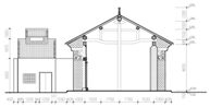 | 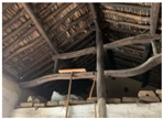 | ■ A key structural feature of this wooden frame is the inclusion of a Middle Column directly within the edged purlin. ■ The two-step and one-step cross beams are symmetrical, featuring irregular curved wood on both sides of the Middle Column. | |
| Round Ridge Roof | 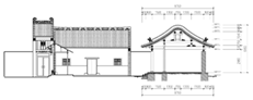 | 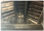 | ■ Round ridge roofs are uncommon in traditional Guanzhong dwellings and are typically found only in certain ancestral halls or specific compounds. | |
| “Sha zi” construction (Half of post-and-lintel construction) | 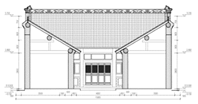 | 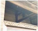 | ■ Due to the single-slope roof of the building’s “Sha zi” (wing room), its framework utilizes a half post-and-lintel construction, a distinctive residential building type in Guanzhong with regional characteristics. ■ The load-bearing structure of the house is based on a wooden frame, similar to post-and-lintel construction. | |
| Column-and-tie construction |  |  | ■ Traditional dwellings in Guanzhong are relatively few, primarily concentrated in Gepai Town in the Qinling Mountain area. ■ Seven purlin columns and three tie beams are used in residential buildings. ■ A series of Dou tie beams are used between the eaves columns, and a Chuan tie beam is employed between the middle column and the eaves columns. Additionally, the tong column and eaves columns are connected using a Chuan tie beam. ■ The wood used for column-and-tie construction is relatively small, and the wooden frame has a simple structure. |
| Wall Category | Pictures of Current Status | Characteristics Description |
|---|---|---|
| Rammed earth wall |  | Based on historical documents, rammed-earth wall construction began during the Shang Dynasty and flourished during the Tang Dynasty, serving purposes such as military defense and space enclosure. Commonly used in Guanzhong residential foundations and walls, this construction method, involving layers of compacted earth, provides thermal insulation, soundproofing, and resistance to wind and cold. |
| Adobe wall |  | In addition to rammed earth walls, the most common type of residential wall in Guanzhong is the adobe wall, also known as the “huwu” wall. This type of wall can be prefabricated in advance and mass-produced, thereby significantly shortening the construction period. Its key feature is the reduction in the wall’s self-weight while allowing for flexible height and thickness. This production method is simple, economical, and efficient. The primary raw material is raw soil, which is molded into adobe bricks of a specific size and dried for several months before being used for masonry. The common sizes of Guanzhong adobe bricks include large (500 × 330 × 55 cm and 400 × 250 × 55 cm), medium (385 × 240 × 55 cm and 385 × 215 × 55 cm), and small (265 × 125 × 55 cm and 230 × 115 × 55 cm). |
| Mixed material wall | 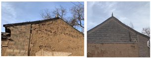 | Different materials are mixed using various techniques to construct the walls. For example, rammed earth can be combined with adobe, adobe with brick, or rammed earth with brick, allowing for flexibility based on the specific conditions of the site. In Guanzhong residential construction, a common practice is to use a combination of rammed earth and adobe masonry. Because both materials share the same raw material, the foundation is typically built with rammed earth up to approximately 20 cm above the ground, followed by an adobe masonry. After the wall is completed, a layer of straw grass tendon mud, 3–5 cm thick, is applied to the surface to protect the adobe from rainwater erosion and ensure the stability of the internal structure. Another method involves a mixture of adobe and green bricks, where the adobe wall is wrapped with green brick, providing additional protection. These walls can be up to 60 cm thick and are commonly found on both sides of mountain walls. |
Disclaimer/Publisher’s Note: The statements, opinions and data contained in all publications are solely those of the individual author(s) and contributor(s) and not of MDPI and/or the editor(s). MDPI and/or the editor(s) disclaim responsibility for any injury to people or property resulting from any ideas, methods, instructions or products referred to in the content. |
© 2024 by the authors. Licensee MDPI, Basel, Switzerland. This article is an open access article distributed under the terms and conditions of the Creative Commons Attribution (CC BY) license (https://creativecommons.org/licenses/by/4.0/).
Share and Cite
Lian, M.; Li, Y. The Spatial Patterns and Architectural Form Characteristics of Chinese Traditional Villages: A Case Study of Guanzhong, Shaanxi Province. Sustainability 2024, 16, 9491. https://doi.org/10.3390/su16219491
Lian M, Li Y. The Spatial Patterns and Architectural Form Characteristics of Chinese Traditional Villages: A Case Study of Guanzhong, Shaanxi Province. Sustainability. 2024; 16(21):9491. https://doi.org/10.3390/su16219491
Chicago/Turabian StyleLian, Mengchen, and Yanjun Li. 2024. "The Spatial Patterns and Architectural Form Characteristics of Chinese Traditional Villages: A Case Study of Guanzhong, Shaanxi Province" Sustainability 16, no. 21: 9491. https://doi.org/10.3390/su16219491
APA StyleLian, M., & Li, Y. (2024). The Spatial Patterns and Architectural Form Characteristics of Chinese Traditional Villages: A Case Study of Guanzhong, Shaanxi Province. Sustainability, 16(21), 9491. https://doi.org/10.3390/su16219491