Article

Comparative Analysis of Electric and Conventional Vehicles Performance in the Evacuation Process of Mount Semeru Eruption Victims Based on Geographic Information Systems

by
Rahmad Inca Liperda
1,
Rahul Prima Putra
2,
Galileo Bill Pairunan
2,
Meilinda Fitriani Nur Maghfiroh
3 and
Anak Agung Ngurah Perwira Redi
4,*
1
Industrial Engineering Department, Faculty of Engineering, Universitas Andalas, Padang 25175, Indonesia
2
Logistics Engineering Department, Faculty of Industrial Technology, Universitas Pertamina, South Jakarta 12220, Indonesia
3
Faculty of Transport and Logistics, Muscat University, Muscat 130, Oman
4
Industrial Engineering Department, Faculty of Engineering and Technology, Sampoerna University, South Jakarta 12780, Indonesia
*
Author to whom correspondence should be addressed.
Sustainability 2024, 16(20), 8939; https://doi.org/10.3390/su16208939
Submission received: 13 August 2024 / Revised: 25 September 2024 / Accepted: 30 September 2024 / Published: 16 October 2024
(This article belongs to the Section Sustainable Transportation)

Abstract

:
The Lumajang Regency is highly vulnerable to various natural disasters, particularly the potential eruption of Mount Semeru. In disaster response efforts, the local government needs to prepare effective and efficient evacuation routes, taking into account the magnitude of the eruption impact in the Semeru disaster-prone area. This research focuses on evacuating vulnerable residents using electric and conventional vehicles. This study is categorized as a vehicle routing problem with energy constraint (VRPEC) because the electric vehicles utilized in this research do not require recharging during their operational process, ensuring rapid evacuation as it is essential. By utilizing Geographic Information Systems (GIS)-based optimization, the best route to evacuate all victims within 12 h is determined. This study involves developing scenarios considering the number of vehicles and their travel distances. There are also evacuation guidelines, including the implementation of priority points and evacuation zone usage. The research results indicate that scenarios EV 5, 8, and 10 are the most optimal for using electric vehicles. Meanwhile, the optimal scenario for conventional vehicles is scenario 5. This analysis shows that implementing electric vehicle scenarios is superior to conventional vehicle scenarios in terms of the total time required to evacuate all victims.

1. Introduction

A disaster refers to an abrupt and unforeseen event causing damage, destruction, or loss of life [1]. These events can be natural, like earthquakes, typhoons, floods, or forest fires, or human-induced, including terrorism, industrial accidents, or infrastructure failures. Disasters can have significant impacts on individuals, communities, and entire regions, leading to property losses, economic disruptions, long-term social and psychological consequences, and even loss of life. Therefore, disaster preparedness, response, and recovery are crucial to minimize the disaster impacts and ensure the safety and wellbeing of the affected population [2,3]. Factors such as global warming, environmental degradation, and growing urbanization are exposing more people to the threat of natural disasters [4]. Figure 1 illustrates the distribution of the number of disasters in Indonesia from 2014 to 2023. The graph demonstrates a consistent increase in the number of disaster events from 2014 to 2023, a trend predicted to persist in the upcoming years [5].
Due to the unpredictable and widespread nature of natural disasters, a swift and coordinated response involving various relevant parties is essential [6]. The logistical efforts carried out in emergency relief operations are commonly referred to as humanitarian logistics [7,8,9,10]. Humanitarian logistics involve the strategic planning, implementation, and control of aid flow effectively and efficiently. It also encompasses the proper management of humanitarian aid storage and information flow. The ultimate goal of humanitarian logistics is to alleviate the suffering of disaster victims [11,12,13].
One crucial aspect of humanitarian logistics is the response during disasters, particularly in evacuation efforts [14,15]. Evacuation is the process of relocating people from an area deemed unsafe to a safer location. Its purpose is to safeguard lives, minimize casualties, and reduce potential damages [16]. The evacuation process involves various stages such as identifying affected areas, evaluating the level of danger, informing the public about the situation, and providing clear instructions on necessary actions. Subsequently, responders or volunteers assist individuals in leaving the impacted area, directing them towards safe havens like shelters or evacuation centers [17,18,19].
Evacuation routes are specifically designed paths to be used during emergencies or hazardous situations, such as natural disasters, facilitating the safe and swift exit of people from an area or building [20]. In its execution, evacuation efforts involve the utilization of specific fleets or vehicles. In recent times, the utilization of electric vehicles (EVs) holds great promise in providing a significant contribution as a future mode of mobility [21,22]. Certainly, utilizing electric vehicles (EVs) in the evacuation process of disaster victims aligns well with Indonesia’s commitment to sustainability. EVs are gaining popularity globally due to their environmental advantages and cost-effectiveness, especially in terms of lower fuel costs [23,24]. The emergence of electric vehicles (EVs) has recently brought up new difficulties and potential in this field, especially in relation to emergency services. Researchers are examining many variables related to the incorporation of electric vehicles (EVs) into emergency response fleets, including the constraints of battery capacity, the presence of charging facilities, and the balance between trip time and energy usage. Research has examined many algorithms, such as heuristic and metaheuristic methods, to tackle these difficulties. For example, Schneider et al. [25] suggest a combination of rules and techniques for solving the electric vehicle routing problem (EVRP) with timeframes. This approach has been modified for emergency services to guarantee quick response times while considering the limitations of electric vehicles (EVs).
Geographic Information Systems (GIS)-based optimization is a commonly used method in solving the vehicle routing problem (VRP). The VRP is an optimization problem in routing deliveries, aiming to determine the most efficient routes and minimize costs in transporting goods using one or multiple vehicles [26]. In the VRP, there is a set of customers with demands that need to be fulfilled and vehicles with limited capacity [27]. The goal is to find the optimal routes accommodating all customers and meeting their demands while minimizing associated delivery costs, such as travel distance, time, fuel, and the number of vehicles required [28]. Another variant of VRP specifically designed for electric vehicles is the vehicle routing problem with energy constraint (VRPEC). The VRPEC deals with the routing of electric vehicles without the option of recharging during their operational processes [29].
Compared to the vehicle routing problem (VRP), the Vehicle routing problem with energy constraint (VRPEC) in emergency rescue scenarios presents several distinctive characteristics: (i) Complex task attributes: In emergency rescue situations, tasks involve multiple attributes such as execution time, urgency, and importance. Special attention must be paid to urgency and importance levels when planning and executing tasks. (ii) Limited recharging opportunities: Unlike typical EVRP scenarios where vehicles can recharge during tasks, rescue vehicles in the VRPEC lack recharging stations during task execution. This absence of recharging stations means that rescue vehicles with limited energy must carefully choose tasks to undertake and optimize the order in which tasks are executed within the given time frame. (iii) Energy consumption as a constraint: In the VRPEC, energy consumption serves as a constraint rather than an optimization objective. Balancing the energy consumption of each vehicle becomes crucial, especially when faced with resource constraints. Efficient energy management is essential to enhance the overall rescue operation’s effectiveness [29]. In essence, the VRPEC in emergency rescue contexts demands a more intricate and strategic approach due to the added complexities of task attributes, limited recharging opportunities, and the critical need for balancing energy consumption among vehicles. These unique challenges require careful planning and optimization to ensure the successful execution of emergency rescue operations.
This study aims to explore the application of electric vehicles (EVs) in evacuating victims of natural disasters in Indonesia, with a specific focus on the Lumajang Regency in Central Java, an area frequently affected by eruptions from Mount Semeru. At present, this study focuses specifically on volcanic eruptions, which was chosen due to the relatively high frequency and impact of such events in the research area. Eruptions differ significantly from other types of disasters due to their unique characteristics. Unlike hurricanes or earthquakes, eruptions might cause a broad range of hazards that last for extended periods. According to Loughlin [30], the gradual accumulation of magma, apparent through geophysical means prior to an eruption, also enhances the likelihood of prediction, while accurate forecasting remains difficult. Many studies also assess the danger of catastrophes caused by large-scale explosive eruptions, necessitating evaluations of the possible locations and timing of these events [31]. Nevertheless, adequate warning periods during eruptions enable disaster agencies to plan and evaluate logistical challenges in eruption cases. There are several safety hazards associated with using electric vehicles (EVs) in disaster relief work, such as fire risk from lithium-ion batteries, risk of electric shock, toxic fumes, infrastructure limitations, and recharging delays and logistical challenges. However, this study focuses on the infrastructure limitations and recharging delays and logistical challenges aspects.
The study utilizes ArcGIS software version 10.8 to address problems and develops models through the “What if Scenario” concept, envisioning potential future events in the Semeru disaster-prone area [32]. The focus lies specifically on evacuating scattered vulnerable populations within this area. Vital information from the Semeru disaster-prone area contingency plan, including the number of vulnerable victims, gathering points, and refugee camp locations, informs the study. ArcGIS is employed to determine optimal evacuation routes for each vehicle. The analysis compares the use of electric vehicles (EVs) with traditional oil-fueled vehicles, providing valuable insights for future applications in disaster response and management. The primary objectives of this research include designing optimal evacuation routes, determining the most efficient time for evacuation, and calculating the necessary number of vehicles needed to evacuate all vulnerable populations when Mount Semeru erupts. By incorporating electric vehicles into this evacuation plan, Indonesia can not only enhance the efficiency of disaster response but also contribute to reducing carbon emissions and promoting sustainable practices in disaster management. This approach aligns with the global push toward environmentally friendly solutions and underscores Indonesia’s dedication to sustainability and disaster preparedness.

2. Materials and Methods

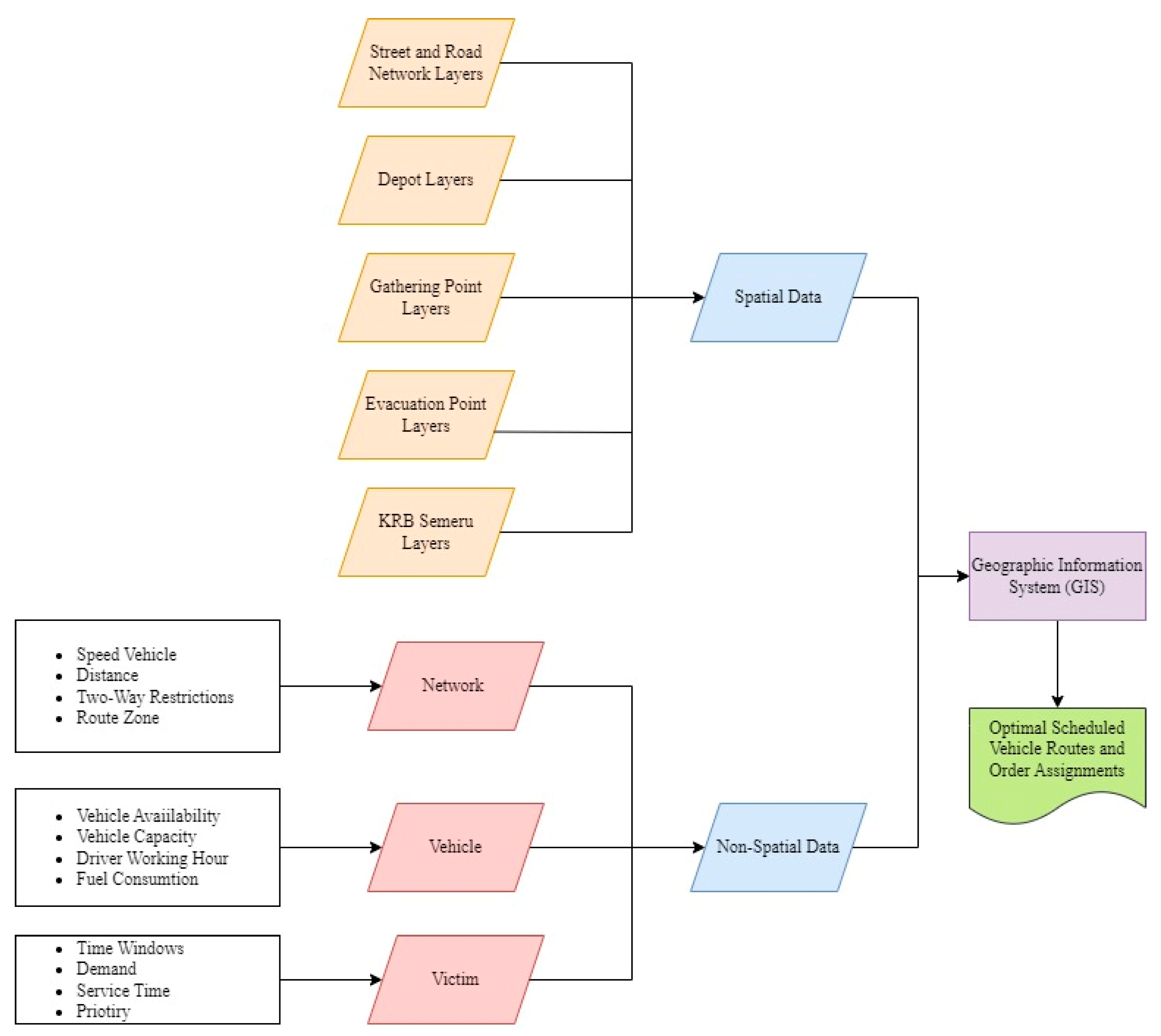
2.1. Conceptual Framework

This research adopts a case study approach, focusing on the eruption disaster of Mount Semeru in Lumajang Regency, East Java. It employs a metaheuristic method facilitated by ArcGIS software version 10.8. The study’s objective is to determine the optimal route and the required number of electric vehicles for evacuating vulnerable populations during the eruption of Mount Semeru. The research methodology aligns with previous studies [33], involving several key steps. It initiates with planning and data acquisition, followed by data processing utilizing ArcGIS 10.8 software. Subsequently, the data undergo verification and validation, leading to the final stage: the analysis of results and drawing conclusions from the study’s findings. The conceptual framework of the GIS is presented in Figure 2.

2.2. Model Formulation

The vehicle routing problem with energy constraint (VRPEC) is modeled involving several sets and parameters essential for evacuation route planning. V = { 1 ,   2 ,   ,   ,   n } represents locations with subsets V r = { 1 ,   2 } and V s = { 9 ,   10 } indicating depots and evacuation shelters, respectively. V r , s = { 1 ,   2 ,   9 ,   10 } refers to the union of these sets, while V t = { 3 ,   ,   8 } and V t , s = V t V s = { 3 ,   4 ,   5 ,   6 ,   7 ,   8 ,   9 ,   10 } denote assembly points and the union of assembly points with shelters. The vehicles are represented by the set K , and the trips by P . Key parameters include T i j the travel time between two locations i to j   ( i , j ) V . D j is the number of evacuees at a given location j   ϵ   V t (person). The vehicle capacity is represented by C a p k while S O C k and S S k refer to the initial and minimum battery levels, respectively. W i represents the initial location of vehicle k   ϵ   K at point j   ϵ   N 1 . The distance a vehicle can travel per battery percentage is denoted by C S k and S P k . Decision variables include X i j k p , which is a binary variable that equals one if the vehicle h H travels directly from vertex i to j   ( i , j ) V by the vehicle k   ϵ   K in trip p   ϵ   P , otherwise it equals zero. Y i j k p reflects the number of evacuees transported on a particular arc. B C i j k p represents the battery consumption from vertex i to j   ( i , j ) V by vehicle k   ϵ   K in trip p   ϵ   P . The mathematical solution formulation used in this research is as follows:
Objective function:
Minimize Z = i V j V T i j X i j k p
Subject to:
X i i k p = 0   i V ,   p P , k K
X i j k p + X j i k p = 0   ( i , j ) V r , s ,   p P , k K
i V X i j k p + l V X j l k p 2   j V ,   p P , k K
j V X i j k p = l V X l i k p   i V t ,   j V : j 3 ,   p P , k K
j V t X i j k p W i k   i V r ,   p P : p = 1 , k K
i V k K p P Y i j k p D j   j V
Y i j k p C a p k X i j k p   i , j V , p P , k K
U i k p U j k p + C a p k X i j k p C a p k D j   i , j V , p P , k K
j V ( X i j k p + X j i k p ) = 0   i V r , p P : p > 1 , k K
j V X i j k p l V X l i k p 1   i V : i V s , p P : p > 1 , k K
B C i j k p = T i j × S P k × C S k   i , j V , p P , k K
i , j V B C i j k p X i j k p S O C k   p P , k K
S O C k p P i , j V B C i j k p X i j k p S S   k K
j V X i j k p = 0   i V : i V s , p P : p = 1 , k K
i V X i j k p S j l V X j l k p S l   j V t , p P , k K
i , j V X i j k p S j γ   p P : p = 1 , k K
i V j V t X i j k p 1 S j l V m V X l m k p S m   p P : p 1 , k K
X i i k p { 0,1 }   i , j V , p P , k K
Y i i k p 0   i , j V , p P , k K
The objective function (1) minimizes the total evacuation time. Constraints (2) prohibit the EV from traveling within itself. Constraints (3) ensure that EVs cannot travel between depots and refugee camps. Constraints (4) restrict the visitation of a node by an EV on each trip. Constraints (5) ensure that every evacuee leaving an assembly point arrives at a refugee camp. Constraints (6) ensure that on the first trip, each EV departs towards the assembly point corresponding to its respective depot. Constraints (7) ensure that the number of evacuees being transported must be equal to the number of victims present at the corresponding assembly point. Constraints (8) explain vehicle capacity. Constraints (9) explain the subtour elimination. Constraints (10) guarantee that on trip p > 1, no assignments should involve traveling to or from depots. Constraints (11) ensure that EVs depart from the last visited refugee camp in the previous trip. Constraints (12) calculate battery consumption based on distance, vehicle speed, and battery characteristics. Constraints (13) ensure that the battery consumption does not exceed the state of charge. Constraints (14) restrict the vehicle from operating again when it is at the lower limit for battery health. Constraints (15) ensure that no assignments occur from refugee camps on the first trip. Constraints (16) emphasize priority levels for assembly points. Constraints (17) ensure that priority nodes are visited. Constraints (18) prevent nonpriority nodes from being visited. Constraints (19) specify the binary variables. Constraints (20) establish the nonnegativity constraints.

3. Results

3.1. Case Study

Lumajang Regency is highly vulnerable to various natural disasters, especially the potential eruption of Mount Semeru. In disaster response efforts, local governments need to prepare effective and efficient evacuation routes. Determining these routes needs to consider the magnitude of the eruption impact and the distance of affected areas from evacuation points to ensure that all areas in Lumajang are served within critical time constraints. The closer an area is to the eruption center, the higher the priority for evacuation in that area. As a nation supporting sustainability concepts, this study will propose the use of electric vehicles (EVs) in the process of evacuating Mount Semeru eruption victims. The outcomes of using EVs will be compared with conventional vehicle usage for future implementation considerations.
This study applies the VRPEC model utilizing GIS-based optimization to find the best routes for evacuating victims of the Mount Semeru eruption disaster. Two evacuation scenarios are considered: one with the implementation of priority areas and one without priority areas. The determination of priority areas in this research is based on disaster-prone regions (KRB) outlined in the Semeru contingency plan. A contingency plan is a document containing the steps to be taken during emergencies like natural disasters, aiming to minimize the negative impacts of such events. This document includes crucial information used in this study, such as the number of vulnerable population victims, gathering point locations, and evacuation site locations. Although no explicit constraints address route overlaps directly, the optimization model inherently seeks to avoid conflicts by designing routes that minimize potential interference between vehicles.
This study has certain constraints. It specifically addresses the Mount Semeru eruption disaster in Lumajang Regency, East Java, concentrating solely on evacuating vulnerable individuals like pregnant women, breastfeeding mothers, elderly, babies, and people with disabilities, as well as infants and toddlers. The vehicles used have a maximum capacity of seven people and a speed limit of 50 km/h. Notably, this study does not account for recharging electric vehicles and does not factor in the investments and costs associated with increasing the number of vehicles used.
This study adopts several assumptions, including that only authorized vehicles, such as ambulances and rescue units, can operate within the evacuation zones to minimize congestion and avoid chaos during the evacuation process. The time required to lift and lower victims from vehicles is 15 min. All vehicles used are uniform. EV battery scenarios at departure from depots are 72%, 59%, 46%, and 33% [34]. The entire road network in the disaster evacuation area is accessible. Conventional vehicles have a fuel tank capacity of 45 L, and one liter of pertalite fuel can cover a distance of 12 km [35]. The success criterion for the scenarios is the ability to evacuate all victims within 12 h. The 12 h evacuation window is critical due to the hazards posed by volcanic activity, such as pyroclastic flows, lahars, and ash fall, which can cause significant harm. Swift evacuation within 5 to 12 h helps prevent casualties, ensures efficient logistical planning, and minimizes exposure to dangerous conditions, especially for vulnerable populations [36].

3.2. Data Processing

The following data processing is carried out.

3.2.1. Input Data into ArcGIS

The initial stage involves constructing a model by inputting essential data such as road networks, depots, gathering points, and evacuation points into the ArcGIS application. To ensure the proper display of data on the map, it is crucial to convert the data format used during input into the ArcGIS layer into a shapefile format. This conversion facilitates the integration and visualization of the data within the ArcGIS environment, allowing for accurate mapping and subsequent analysis.

3.2.2. Network Dataset Creation

After successfully inputting data, the next step involves making modifications to create network datasets based on the road network to be utilized. These modifications are necessary to prepare the road network for analysis within the Network Analyst Extension for tasks like closest facility optimization and route optimization using the vehicle routing problem (VRP) approach.

3.2.3. Optimization Closest Facility

The closest facility analysis is employed to identify the shortest distance between a specific facility point and an incident point. In this study, the closest facility analysis is utilized to determine the nearest evacuation point from each gathering point. This analysis aims to establish a direct link between gathering points and appropriate evacuation locations. The goal is to efficiently match each gathering point with the closest evacuation point, facilitating a streamlined and effective evacuation process.

3.2.4. Optimization Vehicle Routing Problem (VRP)

In this study, GIS-based optimization is conducted through the creation of vehicle routing problem (VRP) models. These models are designed to identify the most efficient evacuation routes, starting from the depot to the gathering point, and then onward to the evacuation point. This advanced stage builds upon the foundation laid by the closest facility optimization. During the optimization process, certain limitations are imposed on the vehicles, including restrictions on the mileage they can cover. To facilitate this, Table 1 shows the detail the conversion between power and vehicle mileage is utilized in this study. This conversion table likely serves as a reference to calculate the distance a vehicle can travel based on its power constraints, allowing for precise optimization and route planning.
The scenario development carried out regarding the power and number of vehicles used can be seen in Table 2.

3.2.5. Route Validation

In order to ensure the safety and efficiency of evacuation operations, it is crucial to validate the routes planned for each vehicle. This validation process includes minimizing the overlap of vehicle routes and avoiding congestion on critical road segments. Figure 3 illustrates a map of road segments traversed by four vehicles assigned to different routes during an evacuation operation. The vehicles are labeled as Vehicle 1 (blue), Vehicle 2 (cyan), Vehicle 3 (red), and Vehicle 4 (purple), with their respective routes shown on the road network in different colors. Despite some overlapping routes, the overall traffic on these road segments remains manageable.

3.3. Results Analysis

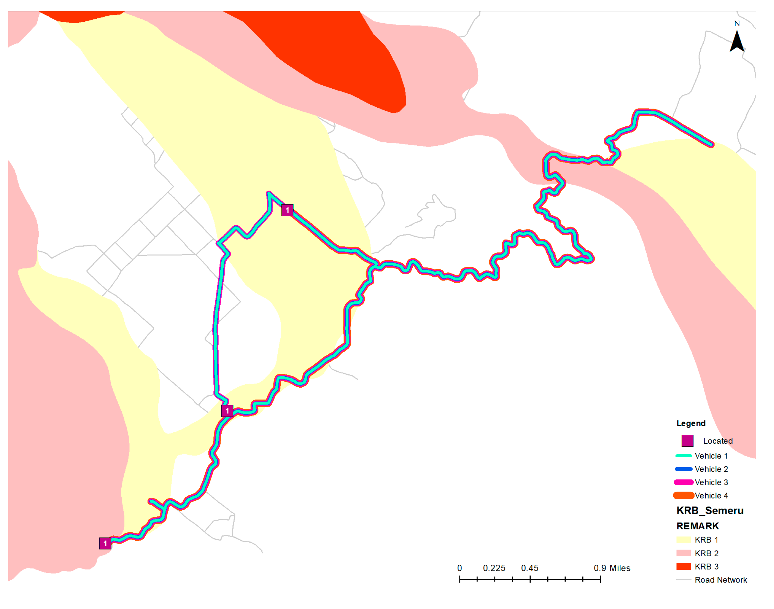
3.3.1. Optimized Routes from VRPEC Optimization

The path derived from the GIS-driven optimization process in each planned scenario represents the most streamlined and efficient route. In every scenario presented, the displayed route covers the shortest possible distance. Assuming a consistent speed, this optimized route also ensures the minimal evacuation time. The following illustrates in Figure 4 is an instance of the acquired route.

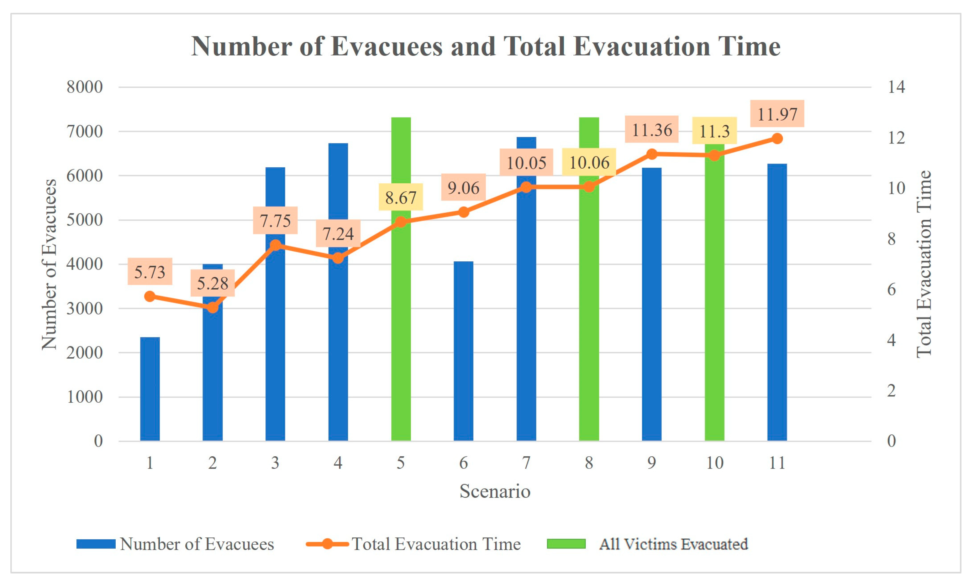
3.3.2. Analysis of the Number of Evacuated Victims and Evacuation Time

The data collection results indicate that there are 7320 vulnerable individuals in the Semeru disaster-prone area (KRB), out of which 3309 are located at priority gathering points. In the event of an eruption, the objective is to evacuate all residents within a strict timeframe of 12 h. This 12 h window serves as a benchmark to assess the feasibility of the scenarios under consideration. The subsequent analysis will be based on these parameters.
  • Scenarios With Priority Points
In this scenario, priority areas have been established to streamline the evacuation process. Figure 5 and Figure 6 show detailed analyses comparing the performance of electric and conventional vehicles in these designated priority areas.
B.
Scenarios Without Priority Points
In this scenario, vehicles have the flexibility to follow evacuation routes without any specific restrictions like priority points. Figure 7 and Figure 8 show analyses comparing the performance of electric and conventional vehicles in this context.

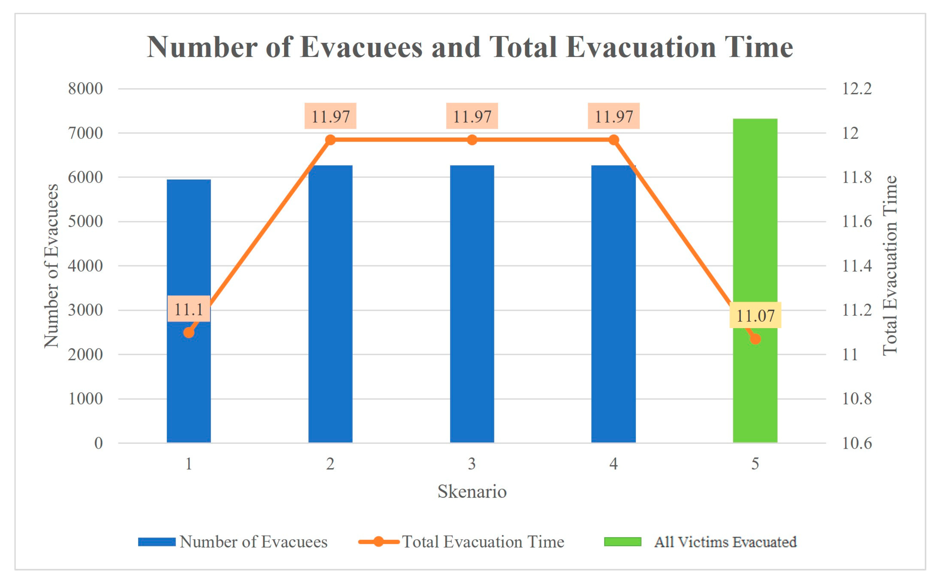
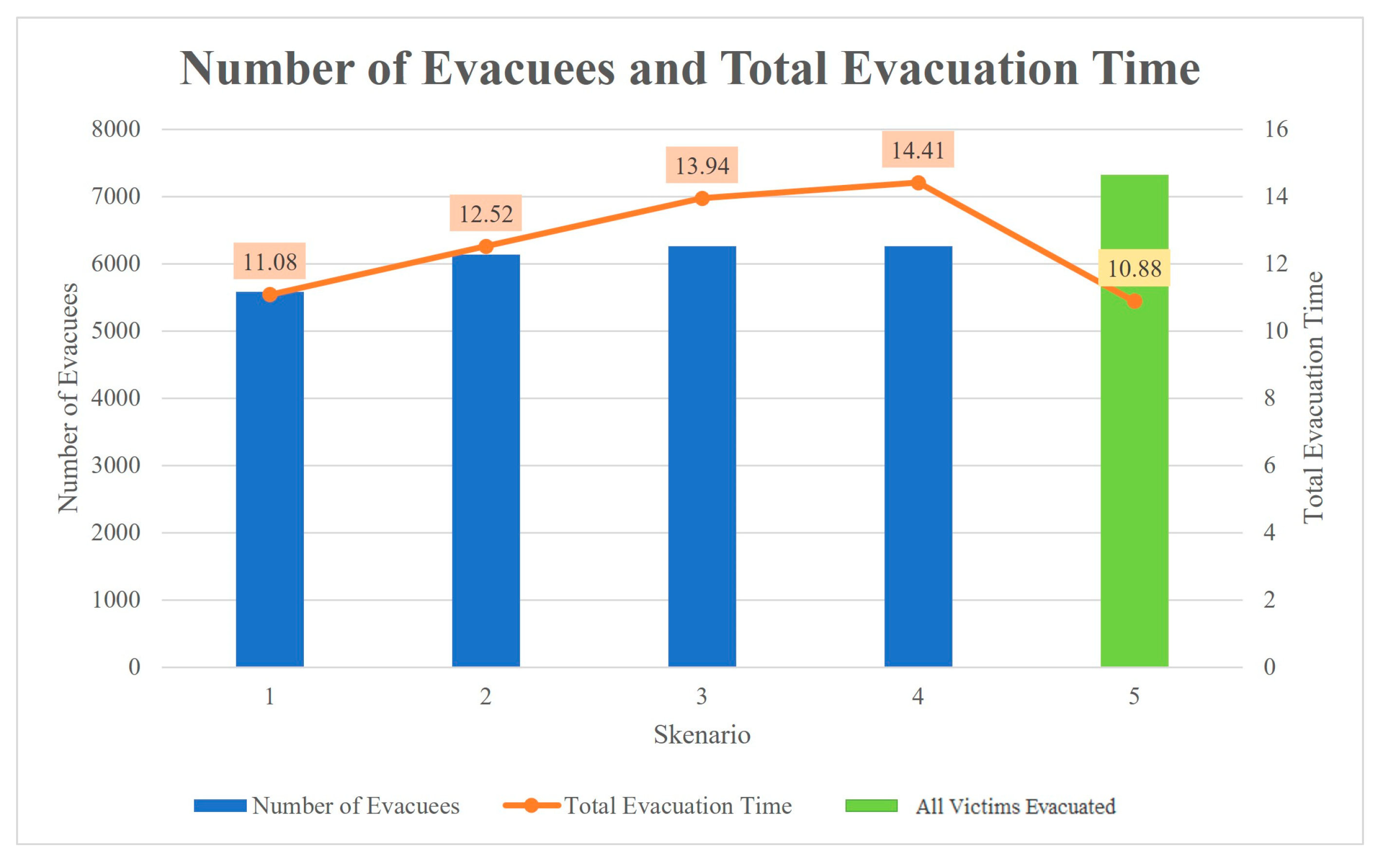
3.3.3. Comparative Scenario Analysis

The summary of the results demonstrates that electric vehicles can successfully evacuate all victims, even under energy constraints, as shown in Section 3.3.2. The green blocks highlight the scenarios where the number of evacuated victims significantly increases while keeping the total evacuation time within a manageable range. This suggests that optimized routing or energy usage strategies can enhance evacuation efficiency despite limited energy resources. Overall, the data support the viability of electric vehicles for large-scale evacuations when appropriate planning and resource management are implemented.
Based on the previous analysis, for each evacuation requirement, there are consistently four selected scenarios: EV scenario 5 with 300 vehicles at 33% battery capacity, EV scenario 8 with 180 vehicles at 46% battery capacity, EV scenario 10 with 120 vehicles at 59% battery capacity, and conventional vehicle scenario 5 with 120 vehicles carrying 15 L of fuel oil. The shorter the time required to complete the evacuation, the more favorable the scenario is for implementation. From the vehicle performance point of view, EVs generally perform better than conventional vehicles in stop-and-go traffic, such as the evacuation process. Electrical vehicles (EVs) were capable of preserving or prolonging their range by using regenerative braking, in contrast with conventional vehicles that experienced larger fuel consumption [38]. The results show that EVs are viable and can be sustainable alternatives for conventional vehicles for mass evacuation efforts. As infrastructure improves and policies evolve to support EVs in disaster preparedness, their advantages will become even more evident. Although conventional fueling stations may have fuel shortages during times of heavy demand, electric vehicle (EV) charging stations may function continuously as long as they have access to a power source [39].
Furthermore, the comparative analysis of the total time conducted reveals that among all the selected scenarios, evacuation provisions that do not involve priority gathering points take less time than scenarios with designated priority points. This indicates that these evacuation provisions represent the most optimal scenario, resulting in minimal evacuation time when evacuating all disaster victims. Subsequently, the analysis will proceed by examining the impact of the number of vehicles on the evacuation time for all the chosen scenarios. The following outlines the completed analysis.
Based on Figure 9, it is evident that the evacuation process is faster when more vehicles are deployed. The graph highlights a clear trade-off: as vehicles increase, the total evacuation time decreases. Conversely, with fewer vehicles, the process takes longer. This underscores the critical role of resource allocation in evacuation planning. More vehicles enhance efficiency, allowing for a quicker evacuation, while fewer vehicles extend the evacuation time, potentially compromising the safety of evacuees. A statistical analysis comparing different scenarios both for EV and conventional vehicles shows that for EVs, SoC and a number of vehicles significantly impact the evacuation time, whereas, for conventional vehicles, only the vehicle number affects the evacuation time, as shown in Table 3.
In real-world scenarios, using a large number of vehicles can lead to increased operational costs. However, given the urgency and precision needed in disaster evacuations, this study prioritizes minimizing evacuation time over cost considerations, as outlined in its limitations.

4. Discussion and Managerial Implications

The use of electric vehicles as a mode of transportation for mass evacuation in emergencies such as volcanic eruptions is innovative but requires proper planning. Managerial implications should involve logistics planning, infrastructure, and human resource and technology management. The following are the managerial implications that need to be considered.
(a)
Vulnerable groups such as the elderly, children, women, and people with disabilities should be identified quickly through local population data. Authorities need to have a clear and structured evacuation priority list.
(b)
Special evacuation routes for vulnerable groups should be planned in such a way as to minimize exposure to hazards. Electric vehicles should be placed at strategic pick-up points that are easily accessible to these groups.
(c)
Pick-up locations should be selected based on accessibility and distance from the danger zone. The location should be identified and prepared in advance with supporting facilities such as seating, shade, and clear evacuation information.
(d)
Fast charging stations should be placed along evacuation routes. Charging locations should be selected by considering the availability of electricity sources and distance from the evacuation zone. A backup EV or energy generator should be prepared for scenarios where the primary vehicle is inoperable due to battery issues or damaged charging infrastructure.
(e)
The need for conventional vehicles is inevitable. The use of EVs can be optimized only for those without private transportation or unable to perform independent evacuation. The authorities should consider to properly evaluate the needs for EVs as mass evacuation mode.
(f)
Mass evacuation simulations should be conducted periodically to ensure that all systems are functioning properly and that all personnel are trained in the use of electric vehicles in emergency scenarios.
Furthermore, some challenges also need to be addressed through targeted policies. Below are key areas where policy and strategy recommendations can be further explored. The government, in collaboration with disaster agencies, could provide subsidies to build charging stations along the evacuation routes and mandate evacuation drills, including provisions for EVs, such as mapping out charging points and ensuring that the emergency responders are trained in managing EV’s related issues. Additionally, policies related to energy sources should also be implemented. To enhance grid stability during emergencies, it is important to devise methods that leverage vehicle-to-grid (V2G) technology, enabling electric vehicles (EVs) to provide electricity to the system.

5. Conclusions

The use of electric vehicles in emergency evacuation processes, especially in the context of volcanic eruptions, offers an innovative, environmentally friendly solution that has the potential to improve the safety of vulnerable groups. After analyzing the processed data, the optimal evacuation routes for the victims of the Mount Semeru eruption have been determined using GIS-based optimization for both electric and conventional vehicles. Following several iterations, four ideal vehicle scenarios emerged: EV scenario 5 with 300 vehicles at 33% battery capacity, EV scenario 8 with 180 vehicles at 46% battery capacity, EV scenario 10 with 120 vehicles at 59% battery capacity, and conventional vehicle scenario 5 with 120 vehicles carrying 15 L of fuel oil (BBM). Among these, EV scenarios 5, 8, and 10, along with conventional vehicle scenario 5, require 7.81 h, 9.97 h, 10.88 h, and 10.88 h, respectively, for the evacuation of all vulnerable population victims.
However, this implementation faces several significant challenges. The limited capacity of electric vehicles, the number of available fleets, and the limitations of battery charging infrastructure are crucial factors that need to be considered to ensure the effectiveness of evacuations. Limited battery capacity affects the range and frequency of charging, which can slow down the evacuation process if not carefully managed. In addition, the number of electric vehicles available may not be sufficient to accommodate mass evacuation needs, especially in situations where time is a critical factor. These limitations require careful logistical planning and coordination between agencies to ensure that electric vehicles can be used optimally.
At present, this study focuses specifically on volcanic eruptions, which was chosen due to the relatively high frequency and impact of such events in the research area. Volcanic eruptions present unique logistical and evacuation challenges, making them an appropriate case for assessing the feasibility of the proposed strategies and models. By concentrating on this type of disaster, we aimed to first establish a solid foundation and proof of concept for our approach. However, we acknowledge that broadening the scope to include additional types of natural disasters, such as earthquakes, floods, or hurricanes, would significantly enhance the generalizability and applicability of the findings. Each disaster type comes with its logistical constraints and dynamics, and expanding the study in this direction could provide more comprehensive insights into disaster management and evacuation processes.
In future research, we intend to explore multiple disaster scenarios to examine whether the models and strategies developed in this study can be effectively adapted to different types of disasters. This expansion would allow us to better understand our approach’s versatility across various contexts and provide more robust recommendations for disaster-prone areas. Additionally, understanding the people’s willingness to adopt and use EVs in a disaster context can be explored. Further studies can be carried out through different approaches. From the policy point of view, reviewing scenarios on policy framework and the incentives for EV adoption might provide better actionable recommendations. On the other hand, future studies can also focus on developing more efficient battery technologies, improving fast-charging infrastructure, and integrating intelligent energy management systems. Incorporating detailed energy consumption models for both conventional vehicles and electric vehicles will provide a more comprehensive analysis of their performance differences. Furthermore, simulations and evacuation planning models that consider variables such as charging speed, evacuation routes, and the priority of vulnerable groups can help in designing more effective evacuation strategies. Although this study simplifies traffic flow, future research could incorporate general traffic scenarios and introduce constraints to avoid congestion, enhancing the model’s applicability in more complex, real-world situations. By overcoming these limitations, electric vehicles could become key to more efficient and sustainable future evacuation systems.

Author Contributions

Conceptualization, R.I.L., M.F.N.M. and A.A.N.P.R.; methodology, R.I.L., R.P.P. and G.B.P.; software, R.I.L., R.P.P. and G.B.P.; validation, R.I.L., M.F.N.M. and A.A.N.P.R.; formal analysis, R.I.L.; investigation, R.I.L., R.P.P. and G.B.P.; resources, R.I.L. and A.A.N.P.R.; data curation, R.I.L.; writing—original draft preparation, R.I.L. and A.A.N.P.R.; writing—review and editing, M.F.N.M.; visualization, R.P.P. and G.B.P.; supervision, M.F.N.M. and A.A.N.P.R.; project administration, R.I.L.; funding acquisition, R.I.L. and A.A.N.P.R. All authors have read and agreed to the published version of the manuscript.

Funding

This research was funded by Directorate General of Higher Education, Research, and Technology, Republic of Indonesia through the 2024 DIKTI Regular Fundamental Research Scheme Research Grant, grant number 827/LL3/AL.04/2024 and the APC was partially funded by Muscat University.

Institutional Review Board Statement

Not applicable.

Informed Consent Statement

Not applicable.

Data Availability Statement

Dataset is available on request from the authors.

Conflicts of Interest

The authors declare no conflicts of interest.

References

  1. Twigg, J. Disaster Risk Reduction; Humanitarian Policy Group: London, UK, 2015. [Google Scholar]
  2. Tierney, K.J. Handbook of Disaster Research; Springer: New York, NY, USA, 2019. [Google Scholar]
  3. Maghfiroh, M.F.N.; Hanaoka, S. Multi-modal relief distribution model for disaster response operations. Prog. Disaster Sci. 2020, 6, 100095. [Google Scholar] [CrossRef]
  4. Guha-Sapir, D.; Vos, F.; Below, R.; Ponserre, S. Annual Disaster Statistical Review 2011: The Numbers and Trends; Centre for Research on the Epidemiology of Disasters (CRED): Brussels, Belgium, 2011. [Google Scholar]
  5. PDSI Pusdatinkom BNPB. Data Bencana Indonesia 2023. Jakarta. 2023. Available online: https://www.bnpb.go.id/buku/buku-data-bencana-indonesia-tahun-2023 (accessed on 19 September 2024).
  6. Chandes, J.; Paché, G. Investigating humanitarian logistics issues: From operations management to strategic action. J. Manuf. Technol. Manag. 2010, 21, 320–340. [Google Scholar] [CrossRef]
  7. Campos, V.; Bandeira, R.; Bandeira, A. A Method for Evacuation Route Planning in Disaster Situations. Procedia Soc. Behav. Sci. 2012, 54, 503–512. [Google Scholar] [CrossRef]
  8. Balcik, B.; Beamon, B.M.; Smilowitz, K. Last Mile Distribution in Humanitarian Relief. J. Intell. Transp. Syst. 2008, 12, 51–63. [Google Scholar] [CrossRef]
  9. Kovács, G.; Spens, K.M. Humanitarian logistics in disaster relief operations. Int. J. Phys. Distrib. Logist. Manag. 2007, 37, 99–114. [Google Scholar] [CrossRef]
  10. Van Wassenhove, L.N. Humanitarian aid logistics: Supply chain management in high gear. J. Oper. Res. Soc. 2006, 57, 475–489. [Google Scholar] [CrossRef]
  11. Thomas, A.S.; Kopczak, L.R. From Logistics to Supply Chain Management: The Path Forward in the Humanitarian Sector. Fritz Inst. 2005, 15, 1–15. [Google Scholar]
  12. Hadiguna, R.A. Pengembangan Model Logistik Kemanusiaan Terintegrasi: Lesson Learned Penanganan Bencana Sumatera Barat. Tek. Industri. Fak. Teknik. Univ. Andalas Kampus Limau Manih 2015, 1–6. [Google Scholar] [CrossRef]
  13. Sigala, I.F.; Wakolbinger, T. Outsourcing of humanitarian logistics to commercial logistics service providers: An empirical investigation. J. Humanit. Logist. Supply Chain Manag. 2019, 9, 47–69. [Google Scholar] [CrossRef]
  14. Maghfiroh, M.F.N.; Hanaoka, S. Multi-Period Evacuation Shelter Selection considering Dynamic Hazards Assessment. Indones. J. Comput. Eng. Des. (IJoCED) 2019, 1, 64. [Google Scholar] [CrossRef]
  15. Zhang, J.; Zhang, X. A multi-trip electric bus routing model considering equity during short-notice evacuations. Transp. Res. D Transp. Environ. 2022, 110, 103397. [Google Scholar] [CrossRef]
  16. Kasereka, S.; Kasoro, N.; Kyamakya, K.; Goufo, E.F.D.; Chokki, A.P.; Yengo, M.V. Agent-Based Modelling and Simulation for evacuation of people from a building in case of fire. In Procedia Computer Science; Elsevier B.V.: Amsterdam, The Netherlands, 2018; pp. 10–17. [Google Scholar] [CrossRef]
  17. UNESCO. Manuals and Guides 82 Intergovernmental Oceanographic Commission Tsunami Evacuations from Inundation to Evacuation Maps, Response Plans, and Exercises Preparing for Community; UNESCO: Paris, France, 2020. [Google Scholar]
  18. Staes, B.; Menon, N.; Bertini, R.L. Analyzing transportation network performance during emergency evacuations: Evidence from Hurricane Irma. Transp. Res. D Transp. Environ. 2021, 95, 102841. [Google Scholar] [CrossRef]
  19. Sheu, J.-B. Mass evacuation planning for disasters management: A household evacuation route choice behavior analysis. Transp. Res. E Logist. Transp. Rev. 2024, 186, 103544. [Google Scholar] [CrossRef]
  20. Abdullah, D.; Fithra, H. Mass Evacuation Transportation Model Using Hybrid Genetic Algorithm. Int. J. Adv. Sci. Eng. Inf. Technol. 2021, 11, 1157–1161. [Google Scholar] [CrossRef]
  21. Maghfiroh, M.F.; Pandyaswargo, A.H.; Onoda, H. Current Readiness Status of Electric Vehicles in Indonesia: Multistakeholder Perceptions. Sustainability 2021, 13, 13177. [Google Scholar] [CrossRef]
  22. Liu, Z.; Wen, F.; Ledwich, G. Optimal Planning of Electric-Vehicle Charging Stations in Distribution Systems. IEEE Trans. Power Deliv. 2013, 28, 102–110. [Google Scholar] [CrossRef]
  23. Shahjalal, M.; Shams, T.; Tasnim, M.N.; Ahmed, M.R.; Ahsan, M.; Haider, J. A Critical Review on Charging Technologies of Electric Vehicles. Energies 2022, 15, 8239. [Google Scholar] [CrossRef]
  24. Ravi, S.S.; Aziz, M. Utilization of Electric Vehicles for Vehicle-to-Grid Services: Progress and Perspectives. Energies 2022, 15, 589. [Google Scholar] [CrossRef]
  25. Schneider, M.; Stenger, A.; Goeke, D. The Electric Vehicle-Routing Problem with Time Windows and Recharging Stations. Transp. Sci. 2014, 48, 500–520. [Google Scholar] [CrossRef]
  26. Laporte, G. The Vehicle Routing Problem: An overview of exact and approximate algorithms. Eur. J. Oper. Res. 1992, 59, 345–358. [Google Scholar] [CrossRef]
  27. Golden, B.L.; Raghavan, S.; Wasil, E.A. The Vehicle Routing Problem: Latest Advances and New Challenges; Springer Science & Business Media: Berlin/Heidelberg, Germany, 2012. [Google Scholar]
  28. Toth, P.; Vigo, D. The Vehicle Routing Problem; Society for Industrial and Applied Mathematics: Philadelphia, PA, USA, 2014. [Google Scholar]
  29. Asghari, M.; Al-e-hashem, S.M.J.M. Green vehicle routing problem: A state-of-the-art review. Int. J. Prod. Econ. 2020, 231, 107899. [Google Scholar] [CrossRef]
  30. Loughlin, S.C. Volcanoes and Volcanic Eruptions; Springer: Berlin/Heidelberg, Germany, 2013; pp. 1077–1088. [Google Scholar] [CrossRef]
  31. Geshi, N. Volcanological challenges to understanding explosive large-scale eruptions. Earth Planets Space 2020, 72, 99. [Google Scholar] [CrossRef]
  32. Golfarelli, M.; Rizzi, S.; Proli, A. Designing What-If Analysis: Towards a Methodology. 2006. Available online: www.qliktech.com (accessed on 28 June 2024).
  33. Suraraksa, J.; Shin, K.S. Urban transportation network design for fresh fruit and vegetables using gis-the case of bangkok. Appl. Sci. 2019, 9, 5048. [Google Scholar] [CrossRef]
  34. Peterson, R.; Awwad, M.A. The Use of Electric Cars in Short-Notice Evacuations: A Case Study of California’s Natural Disasters. In Proceedings of the International Conference on Industrial Engineering and Operations Management, Monterrey, Mexico, 3–5 November 2021. [Google Scholar]
  35. ESCAP United Nation. Study on Challenges and Opportunities for Electric Vehicle Development for Land-Based Public Transport Sector in Cities of Indonesia; ESCAP United Nation: Bangkok, Thailand, 2024. [Google Scholar]
  36. Naismith, A.K.; Phillips, J.; Barclay, J.; Armijos, M.T.; Watson, I.M.; Chigna, W.; Chigna, G. Transitions: Comparing timescales of eruption and evacuation at Volcán de Fuego (Guatemala) to understand relationships between hazard evolution and responsive action. J. Appl. Volcanol. 2024, 13, 3. [Google Scholar] [CrossRef]
  37. Kurniaty, I. Evaluasi Aspek Finansial Penghematan Bahan Bakar Bensin Menjadi CNG (Compressed Natural Gas) Untuk Mobil Pribadi. 2017. Available online: https://jurnal.umj.ac.id/index.php?journal=konversi (accessed on 31 July 2024).
  38. Wang, T.; Tang, T.Q.; Huang, H.J.; Qu, X. The adverse impact of electric vehicles on traffic congestion in the morning commute. Transp. Res. Part. C Emerg. Technol. 2021, 125, 103073. [Google Scholar] [CrossRef]
  39. MacDonald, C.D.; Kattan, L.; Layzell, D. Modelling electric vehicle charging network capacity and performance during short-notice evacuations. Int. J. Disaster Risk Reduct. 2021, 56, 102093. [Google Scholar] [CrossRef]
Figure 1. Distribution of the number of disasters in Indonesia in 2014–2023 [5].
Sustainability 16 08939 g001
Figure 2. GIS conceptual framework.
Sustainability 16 08939 g002
Figure 3. Route validation.
Sustainability 16 08939 g003
Figure 4. Example of route optimization results.
Sustainability 16 08939 g004
Figure 5. The use of electric vehicles in scenarios with priority points.
Sustainability 16 08939 g005
Figure 6. The use of conventional vehicles in scenarios with priority points.
Sustainability 16 08939 g006
Figure 7. The use of electric vehicles in scenarios without priority points.
Sustainability 16 08939 g007
Figure 8. The use of conventional vehicles in scenarios without priority points.
Sustainability 16 08939 g008
Figure 9. Trade-off number of vehicles and evacuation time.
Sustainability 16 08939 g009
Table 1. Power and distance conversion.
Battery Percentage/Fuel CapacityMileage
Electric Vehicles
33%64 km
46%128 km
59%193 km
72%257 km
Conventional Vehicles
15 Liters180 km
21 Liters252 km
27 Liters324 km
33 Liters396 km
Source: [34,37].
Table 2. Scenario development.
ScenarioBattery Percentage/Fuel CapacityNumber of Vehicles
Electric Vehicle
133%60
233%120
333%180
433%240
533%300
646%60
746%120
846%180
959%60
1059%120
1172%60
Conventional Vehicles
115 L60
221 L60
327 L60
433 L60
515 L120
Table 3. Statistical analysis.
Vehicle TypeVariablep-Value
EVBatteries0Significant
Vehicle number0.0002Significant
CVFuel Capacity0.02Not significant at 0.01
Vehicle number0.008Significant
Disclaimer/Publisher’s Note: The statements, opinions and data contained in all publications are solely those of the individual author(s) and contributor(s) and not of MDPI and/or the editor(s). MDPI and/or the editor(s) disclaim responsibility for any injury to people or property resulting from any ideas, methods, instructions or products referred to in the content.

