Abstract
Traditional agricultural landscapes are heavily exposed to change due to their relatively low agricultural productivity. However, they represent cultural values of great importance in maintaining the resilience of the environment and society. Although their cultural potential is important for sustainable development, it is still insufficiently recognized. The article fills this gap by examining old farmstead buildings as a distinguishing element of the agricultural landscape. The study was conducted in Poland in the area of farm settlements in Kashubia. A spatial database and archival maps were used for comparison of the spatial distribution and the number of farmsteads and buildings in 1937 and 2020. The types of settlements in the selected area of research were recorded and classified. The results obtained from the study may support the spatial planning and local management of agricultural areas for the purpose of preserving rural identity and economy.
1. Introduction
The following article originates from the need to document tangible goods provided by rural culture—they are disappearing from the landscape at a fast pace—before their significance as heritage can be established. In this case, heritage is understood as all tangible and intangible goods that hold emotional value for depositors. The users’ and stakeholders’ emotional attitude towards heritage leads them to engage in the protection of its resources. The inclusion of cultural assets recognized as heritage in the process of managing changes to a given territory is conducive to the goals of holistic sustainable development [1,2,3,4]. The importance of managing the heritage of the landscape is recognized by the international community, as expressed in various seminal documents based on the Sustainable Development Agenda [5]. Some of these documents concern, either directly or indirectly, the protection of rural landscapes and agriculture (Table 1).
In this research, landscape is understood under the recommendation of the European Landscape Convention as an area “perceived by people, whose character is the result of the action and interaction of natural and/or human factors” [6]. Hence, the heritage of agricultural landscapes refers to the material elements and features of nature and culture that were socially generated in the course of agricultural production [7]. However, accepting the value of agricultural assets as heritage requires local knowledge, which is still rather limited. This knowledge concerns the scope of the number, distribution, and characteristics of family-run farm developments in Poland.

Table 1.
Selected international and European documents that support agricultural landscape heritage (elaborated by A. Górka).
Table 1.
Selected international and European documents that support agricultural landscape heritage (elaborated by A. Górka).
| Sustainable Development | Cultural Heritage Protection and Management |
|---|---|
| Sustainable Development Agenda, 2030 [8] | European Landscape Convention, Florence [6] |
| European Green Deal [9] | Council of Europe Framework Convention on the Value of Cultural Heritage for Society, Faro [10] |
| EU Territorial Agenda 2030 [11] | European Cultural Heritage Strategy for the 21st Century, Cyprus [12] |
| Rural areas | |
| Rural Development Programme [13] | |
| Principles Concerning Rural Landscapes as Heritage [14] | |
| Globally Important Agricultural Heritage Systems [15] | |
| Soil Strategy for 2030 [16] | |
| Long-term vision for the EU’s rural areas [17] | |
Small groups of buildings that form clusters and belong, or used to belong, to one family-run farm are part of agricultural landscapes in many parts of Europe and worldwide. Despite the transformation of agriculture, diverse development forms and the development of traditional field-adjacent homesteads still constitute part of the vital cultural wealth of the countryside [18]. These elements form the users’ identity; they contribute to the genius loci. They provide scenic value and increase the attractiveness of the landscapes. Even if no longer associated with the production function, they are often carefully maintained and proudly present as a legacy of past generations, as is the cases, for example, of Styria, Austria, or Denmark [19,20]. Maintaining farmstead heritage supports the expansion of tourism and other cultural projects that restructure the economic foundations and ensure the present and future well-being of the rural inhabitants under the conditions of agricultural transformation [21].
In Poland, small family-run farms still provide basic rural development. Together with the accompanying greenery, their development serves as a determinant of the traditional agricultural landscape structure; in many regions, it determines the visual attractiveness of the area. Long after World War II, rural buildings in the northern and western regions of Poland, e.g., in Pomerania, were considered a difficult heritage due to their German origin. Until today, such buildings have not been covered by effective care or legal protection. Currently, the social awareness of their importance as a testimony to the everyday life of the former village is slowly rising. The inclusion of Poland in the Common Agricultural Policy (since 1994) has resulted in economic and social transformation. Modernized or abandoned buildings of old farms are now adjacent to modern housing complexes that interfere in disorderly ways with the systems of agricultural settlements. Numerous renovations are being introduced to improve energy efficiency, which makes it difficult or impossible to recognize the architectural features of old farmhouses. Even though they may be important for the future development of the village, old farmhouses are disappearing from the agricultural landscape. Therefore, the valorization of vulnerable, attractive building complexes and their landscapes, as well as local heritage policy, needs to be enhanced. For this reason, the methods and tools used for description need updating to adapt the research process and results to social circumstances and make them more accessible.
In this study, a settlement pattern is understood as a characteristic, outstanding spatial arrangement of buildings which constitutes one of the features of land cover and land use as well as of the visual landscape. Currently, typical settlement patterns of an agricultural landscape in Poland comprise compact villages, isolated farms with field-adjacent, multi-building farmsteads, and areas of dispersed one-family houses situated on small plots created as a result of dividing former arable fields. This work examines the spatial distribution of traditional farmsteads and contemporary scattered one-family houses as well as the alteration in homestead layouts in order to identify the scope of building changes in an area previously occupied only by farmstead constructions, thereby facilitating in-depth investigation of dispersed old farm buildings. The implemented project transfers the available methodology used in cultural landscape studies [22,23] to the GIS environment to increase the availability of data concerning local rural management and spatial planning. It determines the location of the preserved old homesteads, which leads to the identification of agricultural areas with relatively intact settlement patterns that might require protection. The method was tested through its application to a research area located in Kashubia, Poland, in the area where traditional agricultural settlement is threatened by urbanization.
2. Materials and Methods
2.1. Study Area
The study was conducted on a 10 km × 10 km research area in the northern part of Poland, i.e., Gdańsk Pomerania. The study area was located in the Kashubia cultural region (Figure 1).
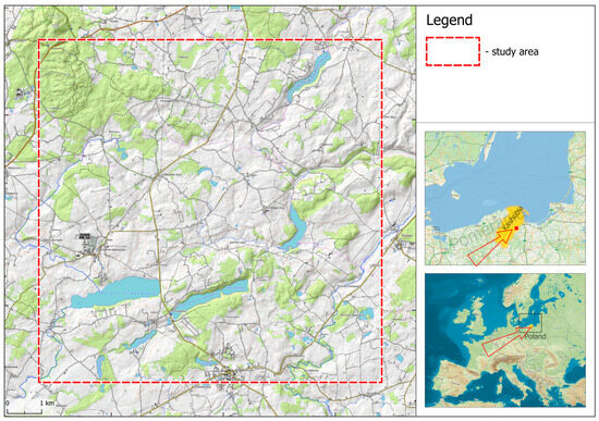
Figure 1.
The study area (visualized by K. Niecikowski).
The study area comprises a natural and cultural complex with unique, distinctive physiognomy. It is characterized by a post-glacial, varied relief and has an irregular network of small agricultural building complexes adapted to it (Figure 2). Homesteads in this area are usually referred to as the Kashubian wasteland or wilderness, which probably results from their location among lakes and forests, as well as the distance from the village or the infertility of the land [24]. Kashubians are descendants of Slavic tribes that once inhabited Pomerania. To this day, the group has developed and preserved their cultural integrity, which is expressed in their language. Their cultural identity is expressed in a strong connection with the territory they inhabit, which makes them unwilling to divest their land despite the unprofitability of agriculture.
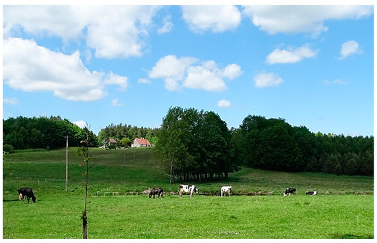
Figure 2.
An old farmstead in the study area (photo by A. Górka).
From the First Partition of Poland in 1772 to 1918, the area belonged to Prussia. The agrarian and Germanization policy conducted by the Prussian authorities exerted the greatest impact on the landscapes of the Kashubian wastelands. Originally, the development of settlements in this area was linked to the exploitation of its forests to supply charcoal for the needs of numerous tar factories and glassworks. From the 18th century onwards, numerous small villages were established in the formerly deforested areas.
The formation of the modern landscape of dispersed settlements began with the parceling of land that formerly constituted church and royal estates. This process followed the takeover of these lands by Prussia. In the 19th century, as a result of the reconstruction of Prussian countryside, block or strip fields with adjoining farmsteads were sectioned [25]. The study is based on the classification of morphological types of historical villages and their buildings adopted in Polish literature [26,27].
The Prussian settlement was regular; farmsteads were located along rural roads. The consecutive parceling processes conducted by Polish companies were less regular, with farmsteads situated away from local roads [28]. In the interwar period, the Polish authorities continued to divide public land and the previously German-owned estates. During the military operations of World War II, many farms were destroyed. Further destruction was inflicted by the Soviets during the so-called “liberation defeat” when the farms of the Germans, the Polish, and Kashubian people were being robbed and destroyed. After the war, large farms were subject to partitioning. Despite the later forced collectivization, the fragmented agriculture of family-run farmsteads was retained [29]. Today, the owners of former small fields tend to divide them to create building plots in unplanned ways.
The building development of old, dispersed farmsteads had traditional, recognizable formal features, such as a small scale and a concentration of houses with 1–3 farm buildings. These developments were usually located around a rectangular farm yard. The architectural features of Kashubian farm buildings have been shaped by the regional folk tradition, as well as by Prussian economic and social policy. Houses were traditionally built of wood; they mainly had a frame structure filled with clay or, under Prussian jurisdiction, with brick. They were one-story and squat, with a high gable roof. Alternatively, they were two-story with a gable roof with a very small slope [30,31]. Livestock buildings were built of brick and stone (Figure 3). Tall barns were erected of wood.
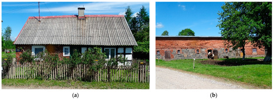
Figure 3.
Historic farm buildings in the study area: (a) a house of mixed construction (of brick, half-timbered) with a high, steep roof; (b) a cowshed of brick and stone with a semi-flat roof (photos by A. Górka).
Today, many homesteads remain inactive or generate low production. Even though the old farm buildings and agricultural landscapes constitute evidence of the valued diversity of European rural culture, they are being demolished or arbitrarily rebuilt.
2.2. Materials
The study was conducted in QGIS 3.22. To provide comparative historical material, the maps of the Military Geographical Institute, created in the years 1919–1939, were selected. These constitute the most complete and time-coherent collection of archival maps for Gdańsk Pomerania. The leading materials included the following:
- Vector layer of buildings derived from the Topographic Objects Database (BDOT) 1:10,000, 2020;
- Orthophoto map of the Head Office of Geodesy and Cartography (GUGiK), 2020;
- Digitized, archival topographic maps 1:25,000 of the Military Geographical Institute (WIG), 1937.
Auxiliary materials used to help clarify the dating of farmsteads included the following:
- Digitized, topographic maps 1:10,000 of the Head Office of Geodesy and Cartography (GUGiK), 1983;
- Orthophoto map (GUGiK), 2021.
2.3. Methodology
The research subject comprises the distribution of dispersed family-run farmsteads or hamlets (that consist of several farmsteads) located outside compact villages and erected before 1937. The map content analysis in QGIS (Figure 4) includes the following:
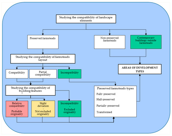
Figure 4.
Comparative analysis of the content provided by the maps, step by step, to identify changes to the development patterns (elaborated by A. Górka).
- The identification of the preserved farmsteads and former positions of the already-non-existent farmsteads from 1937, together with new buildings located beyond them, to provide a common base for both subsequent stages; a comparison of the patterns formed by buildings, roads and water, woodland, meadows, and fields on the maps from 1937 and 2020.
- The identification of the originality of the buildings in the farmsteads from 1937; a comparison of the features of the buildings.
- The classification of old farmsteads according to the degree of preservation of their original substance, as well as the division of the study area depending on the development type.
The procedure for identifying old farmstead buildings involves a reconciliation of the outlines included in the 2020 BDOT database and the buildings on the 1937 maps, comparing the data provided by both maps and verifying them (see Figure 4):
- The comparison of the farmstead layouts on maps from 1937 and 2020 leads to determining which of the buildings in the preserved farmsteads are likely to be the original 1937 buildings.
- The comparison of the size and proportions of the outlines of the farmstead building on the map from 1937 and 2020 and the observation of these on the orthophoto map (e.g., steep roofs in the past or flat roofs nowadays) leads to the verification of the originality of the buildings in the preserved farmsteads.
The farmstead buildings that bear significant correspondence, or limited correspondence, to the building outlines on the archival maps, as well as buildings that are certainly contemporary, are identified in the database.
The following types of old farmsteads are distinguished depending on the number of preserved buildings from 1937:
- Transformed (no element of the original layout preserved);
- Partially preserved (less than 50% of buildings of the original layout preserved);
- Half-preserved (at least 50% of the buildings of the original layout preserved);
- Fully preserved (all buildings of the original layout preserved).
The research area is subsequently divided into subareas depending on the spatial distribution of farmstead types and new buildings. This is achieved with the use of Voronoi diagrams.
3. Results
By comparing the location of selected objects on the archival maps with their location on the contemporary orthophoto map, frequent discrepancies in their spatial placement were identified. In some cases, location differences on the maps amounted to 50 m (Figure 5b). These discrepancies may be due to such aspects as the uncertain mathematical basis of the cartographic representation used on the archival topographic maps; the inaccuracy of the geodetic instruments used at that time; and the inaccuracy of the calibration of the raster map sheets [32]. To confirm the probable identity of objects on the orthophoto map from 2020 and on the maps from 1937, the following auxiliary maps were used: a raster topographic map 1:25,000 from 1983; and an orthophoto map from 2021.
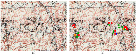
Figure 5.
Results of the comparison of the map content in QGIS 3.22. (a) Archival map from 1937, 1: 10,000. (b) Archival map from 1937 with buildings from the 2020 database and their dating assessment. Probable original buildings:  ; buildings of non-excluded originality:
  ; buildings of excluded originality:
  ; non-existent buildings:
  (elaborated by A. Górka).
; buildings of non-excluded originality: ; buildings of excluded originality: ; non-existent buildings: (elaborated by A. Górka).
Within the study area, 434 farmsteads were located in 1937, 33% of which had been demolished by 2020 (Table 2). Most farms had disappeared by 1983 (as a result of the destruction during World War II). In the period 1983–2020, only 5% of farmsteads were demolished. Between 1937 and 1983, few new farmsteads were established, and some of these did not survive until 2020. No farms established after 1983 were identified in the study area. There were a few new residential buildings in the vicinity of the farmsteads. Due to minor changes that occurred as a result of urbanization in the years 1937–1983, this phase was not distinguished or used to illustrate the contemporary settlement pattern.
Table 2.
Farmsteads existing according to years (elaborated by A. Górka).
Despite the use of auxiliary sources and the multi-level interpretation in accordance with Figure 4, it was impossible to determine with certainty that the buildings on the archival and the contemporary maps were identical. Hence, the research resulted in indicating buildings that were likely original (with full compatibility of the position of the farmstead relative to the neighboring elements on the map, a high degree of compatibility of the position of the building in the farmstead layout, and relative compatibility of recognizable architectural features) and buildings whose originality could not be excluded (with full compatibility of the position of the farmstead relative to the neighboring elements on the map, limited compatibility of the position of the building in the farmstead layout, and slight deviations in its architectural features). Elements of certainly more recent origin and absent from the archival maps were also indicated (Figure 5).
Of all the buildings included in the BDOT database, 21 were not present on the orthophoto map. The orthophoto map only showed traces of foundations or no traces at all. The few buildings—probably new ones—visible on the orthophoto map were not included in the database. Buildings not listed in the database were not included in the calculations. A total of 2310 buildings were analyzed in the study area. Among these, 74% of the buildings were recognized as contemporary ones in and outside the old farmsteads; 15.7% were probably original buildings whose outlines showed high degrees of compatibility with the buildings on the archival map, whereas 10.3% were considered buildings whose originality cannot be excluded (Table 3).
Table 3.
Building originality assessment in preserved farmsteads (elaborated by A. Górka).
Based on the dating of the farmstead buildings, a classification of farmsteads was conducted (Figure 6) to determine the possible concentrations of their types.
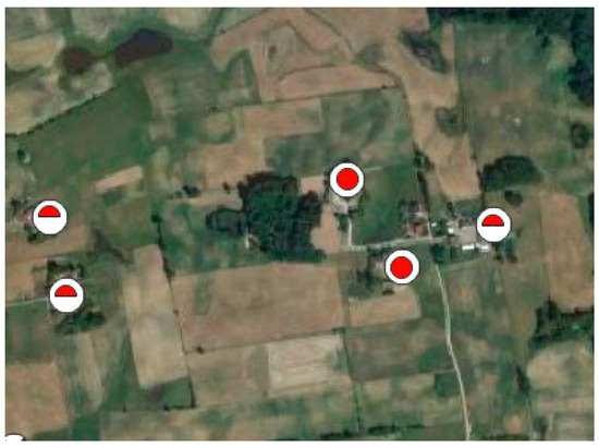
Figure 6.
Determination of old farmstead types according to the degree of substance preservation—the 2020 ortophoto map, QGIS 3.22; completely preserved farmstead:  ; half-preserved farmstead:
  (elaborated by A. Górka).
; half-preserved farmstead: (elaborated by A. Górka).
The historic substance of 84.9% of the original farmsteads underwent transformations to varying degrees (Table 4), but only 27.5% of homesteads were fully converted. Of the 44 fully preserved farmsteads, only 11 contained no new buildings and maintained the original shape. Also, in the majority of the half-preserved and partially preserved farmsteads, new buildings were erected, often outside the traditional layout determined by the farmyard.
Table 4.
Number of old farmsteads according to the building substance originality (elaborated by A. Górka).
The majority of farmsteads may be defined as half-preserved; i.e., at least 50% of their historic substance was preserved (for example: in a two-building homestead, one building was preserved; in a three-building homestead, two buildings were preserved). The types of farmsteads are varied; hence, no areas in which any type of homestead dominated were determined.
Voronoi diagrams were created for points that represent isolated farmsteads and dispersed buildings to identify the distribution spatial pattern of the building. To determine the range of compact building development and the concentration of demolitions to isolated farmsteads, buffering was applied around the points that represent the buildings of the compact village and around the points that represent non-existent farms with a radius of 75 m and 300 m, respectively (Figure 7). The distances used correspond to the historical settlement structure. The layers were generalized by removing all the isolated points and buffers. This resulted in the determining the areas of the following:
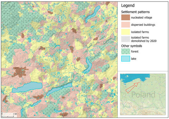
Figure 7.
Changes to settlement patterns in the study area (visualized by K. Niecikowski).
- Isolated farmsteads, i.e., the areas where the agricultural building system from 1937 was retained;
- Dispersed buildings, i.e., the areas where new non-agricultural buildings emerged;
- Demolished isolated settlements, i.e., the areas where the majority of farms had been demolished by 2020.
The results show that areas of isolated farmsteads have intermingled with modern non-agricultural building development, whereas modern development has been expanding radially around the largest villages, regardless of their location. The spatial–temporal transformation pattern of the settlement has been defined as follows:
- Until 1937, the study area was occupied by the buildings of nucleated villages and single farmsteads;
- In the period from 1937 to 2020, many farm settlements disappeared (most probably by 1945 as a result of war hostilities); this created irregular areas of demolition concentration;
- By 2020, non-agricultural building development with a spatially disordered distribution covered some areas of the former war demolition concentration and some of the agricultural building development areas.
Currently, the areas occupied by agricultural and non-agricultural buildings are almost equal in size and amount to 31.5% and 33.8% of the research area (Table 5), respectively.
Table 5.
Land cover within the study area (elaborated by A. Górka).
4. Discussion
The significance of the above project lies in its transferring the effects of an analysis of map content, typical for landscape biography research, to a spatial database, thereby increasing the scope and availability of knowledge. The results obtained from the study may draw attention to the scale of changes in old construction resources. They help monitor the transformations of vast areas and indicate areas for detailed research. A rural data platform using such spatial data may be used for informing users and other stakeholders. Owing to the conveniences of digitization, their participation at each stage of the research, i.e., at the stages of a preliminary analysis of the maps, field research or classification, or description and judgment, is more beneficial (Figure 8).
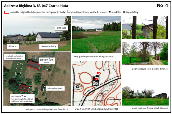
Figure 8.
A sample inventory card from the study on architecture and visual landscape conducted in the current research area (elaborated by A. Górka).
The value of the method lies also in the use of simple and available means adapted to specific circumstances; thus, the method may immediately be bottom-up applicable [33]. The spatial distribution and typology of small farms located in various regions of Europe, including Poland, were studied by Guiomar and his team [34]. The researchers indicated the diversity-related, cultural, productive, and environmental importance of such farms and advocated that research should be undertaken at lower levels.
The identification of both the location and spatial distribution of landscape resources provides an obvious introduction to the designation of various types of areas and their classification in a selected order. In the current pilot project, identifying old farmsteads is aimed at designating those agricultural landscapes that hold a potential cultural and visual value that might require protection. Initiating a systematic assessment process is critical in areas of rapid change where material and cultural goods, which should be discussed, are disappearing. As noted by Antrop [35], the 19th-century European heritage fails to be sufficiently recognized.
In-depth research is indispensable in verifying and developing conclusions from cartographic analyses. The results of a comparative interpretation of archival and contemporary maps can serve as guidance for expert field research so as to provide information on the condition and aesthetics of traditional buildings and open landscapes. Based on the obtained results, research on architecture and the visual landscape was conducted in selected areas of the research field [36,37]. The visual survey was conducted along the two scenic routes running through the areas of old isolated farms designated in the presented study. The architectural features of 83 buildings in 26 farmsteads indicated as fully preserved or half-preserved in the current research were documented and described (Figure 8). The outcomes of the cartographic study helped verify the origins of modified, degraded, and ruined buildings. After recognizing the architectural and landscape values of old farmstead buildings, their physical condition, their adaptation potential, or the recovery of materials used in them may be examined.
Studies of maps and building features covering the entire county would offer a possibility to define the local goals of renovation strategies for spatial policy and economy, taking into account the protection of farm buildings which co-create the beauty of the agricultural landscape (Figure 9).
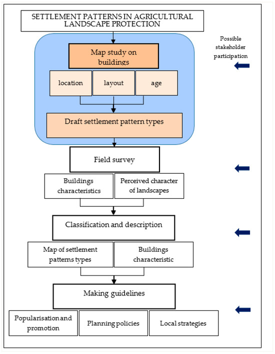
Figure 9.
Procedure for assessing settlement patterns of agricultural landscape (the tested stage is marked in color) (elaborated by A. Górka).
The popularization of our findings could support an increase in the value of these farmsteads as cultural heritage. The example of the English and the new English countryside ideal, shaped in the times of tourist consumption since the 19th century, indicates that the commitment of private property owners to maintaining or restoring the appearance of the landscape depends on a canon of its beauty that strongly influences public opinion [38]. On this basis, it may be assumed that the traditional farmsteads would be more effectively protected if public perception regarding their role in shaping the attractiveness of the agricultural landscape was stimulated by new data. Rural e-platforms, open access to knowledge, and stakeholders’ participation in local planning and management could raise public awareness and provide a basis for changing opinions on what heritage is [39].
The family-run farms in Kashubia, Poland, provide characteristic elements of the traditional agricultural landscape. Small groups of buildings, separated by fields, together with the accompanying greenery, serve as landmarks that structure the landscape; they facilitate understanding and encourage exploration [40]. Their persistence within the landscape supports the continuity of collective memory and local identity. Therefore, it is necessary to ensure the continuity of their existence once they have lost their agricultural function. Homestead objects should continue to be used due to their cultural value. Their visuality gains importance in the multifunctional rural economy, where incomes from tourism and culture-based services are on the increase. Under these circumstances, it is important to socially appreciate, study, and protect the scenic and image-related values of old homesteads.
5. Conclusions
The study was conducted based on the following general assumptions:
- The traditional building of family-run farms constitutes an element of the heritage of agricultural landscapes.
- The remote assessment of changes to agricultural settlements supports the protection of heritage and the sustainable development of rural areas.
The research described was conducted on the example of the development of the so-called Kashubian wastelands in Poland, which emerged as a result of native traditions and foreign cultural influences at the turn of the 19th and 20th centuries. They represent the multicultural richness of Europe’s agricultural landscapes and deserve care as they are at risk of disappearing. A qualitative analysis of the content of archival and contemporary maps, typical of landscape biography studies, was conducted in the GIS environment in order to detect changes in the agricultural settlements under research. Quantitative results are approximate but provide good guidance for in-depth research. The traditional buildings of former farmsteads were identified. Settlement patterns were distinguished in the research field. The research results prove that extensive changes took place in the settlement structure of the study area in the years 1937–2020. In this period, a significant part of the agricultural building development disappeared. However, many new residential buildings were erected outside the preserved homesteads and the densely built-up areas of villages. However, enclaves of relatively intact traditional agricultural settlements still exist and require protection. This indicates the need for more detailed research on them in the future. Revealing the resources of traditional farm buildings may initiate the process of their valorization. Using the GIS methodology supports this valorization, as well as the more effective management of cultural landscapes.
Under the conditions of sustainable development aimed at increasing biocultural resistance, traditional farmsteads should last. They have significant potential for a socially driven bottom-up restoration of the agricultural heritage landscape. The applied research approach is likely to ensure that agricultural heritage landscapes remain a daily experience for generations to come.
Funding
This research received no external funding.
Institutional Review Board Statement
Not applicable.
Informed Consent Statement
Not applicable.
Data Availability Statement
Data supporting the obtained results can be found on the following pages: http://igrek.amzp.pl/; http://geoportal.gov.pl (accessed on 10 April 2022).
Acknowledgments
I would like to thank my colleague Kazimierz Niecikowski for the technical support of the project.
Conflicts of Interest
The authors declare no conflicts of interest.
References
- Fowler, D.D. Ethics in Contract Archaeology. In Ethics and Values in Archaeology; Green, E.L., Ed.; Free Press: New York, NY, USA, 1984; pp. 108–116. [Google Scholar]
- Lowenthal, D. Stewarding the Past in a Perplexing Present. In Values and Heritage Conservation; Avrani, E., Mason, R., de la Torre, M., Eds.; The Getty Conservation Institute: Los Angeles, CA, USA, 2000; pp. 18–25. [Google Scholar]
- Gutowska, K.; Kobyliński, Z. Zarządzanie dziedzictwem kulturowym: Nowa dziedzina nauczania akademickiego i badań naukowych [Cultural Heritage Management: A New Field of Academic Teaching and Research]. Maz. Reg. Stud. 2011, 6, 51–72. Available online: http://cejsh.icm.edu.pl/cejsh/element/bwmeta1.element.desklight-698816dd-1e5e-4912-8959-bcaed1d8b62c (accessed on 5 January 2019).
- Konior, A. Cultural Heritage Management in the Context of the Revitalization Process of Post-Industrial Areas; Institute of Culture of the Jagiellonian University: Cracow, Poland, 2021; pp. 21–84. [Google Scholar]
- Jongman, R.H.G. (Ed.) The New Dimensions of the European Landscapes; Springer: Wageningen, The Netherlands, 2004. [Google Scholar]
- Council of Europe. European Landscape Convention (ETS No. 176). 2000. Available online: http://conventions.coe.int/Treaty/en/Treaties/Html/176.htm (accessed on 10 January 2012).
- Mitchell, N.J.; Barrett, B. Exploring Agricultural Heritage Landscapes: A Journey Across Terra Incognita. Georg. Wright Forum 2017, 34, 180–194. Available online: http://www.georgewright.org/forum_issues (accessed on 15 May 2022).
- UNMS (United Nations Member States). The Agenda for Sustainable Development 2030. 2015. Available online: https://sdgs.un.org/2030agenda (accessed on 1 June 2022).
- European Commission. European Green Deal. 2020. Available online: https://commission.europa.eu/strategy-and-policy/priorities-2019-2024/european-green-deal_en (accessed on 30 April 2021).
- Council of Europe. Convention on the Value of Cultural Heritage for Society (CETS No. 199). 2005. Available online: https://www.coe.int/en/web/culture-and-heritage/faro-convention (accessed on 15 March 2022).
- European Union Ministers Responsible for Spatial Planning, Territorial Development and/or Territorial Cohesion. Territorial Agenda 2030 of the European Union. 2021. Available online: https://ec.europa.eu/regional_policy/en/information/publications/brochures/2021/territorial-agenda-2030-a-future-for-all-places (accessed on 30 April 2021).
- Council of Europe. European Cultural Heritage Strategy for the 21st Century. 2017. Available online: https://www.coe.int/en/web/culture-and-heritage/strategy-21 (accessed on 15 March 2022).
- European Commission. Rural Development Programms for 2021–2027. 2020. Available online: https://agriculture.ec.europa.eu/common-agricultural-policy/rural-development_en (accessed on 15 March 2022).
- International Council on Monuments and Sites International Federation of Landscape Architects. Principles Concerning Rural Landscapes as Heritage. Adopted by the 19th ICOMS General Assembly, New Delhi, India, 15 December 2017. 2017. Available online: https://www.icomos.org/images/DOCUMENTS/Charters/GA2017_6-3-1_RuralLandscapesPrinciples_EN_adopted-15122017.pdf (accessed on 15 January 2022).
- United Nations’ Food and Agricultural Organization. Globally Important Agricultural Heritage Systems. 2002. Available online: https://www.fao.org/events/detail/20-years-of-globally-important-agricultural-heritage-systems (accessed on 15 March 2022).
- European Commission. Soil Strategy for 2030 Reaping the Benefits of Healthy Soils for People, Food, Nature and Climate. 2021. Available online: https://eur-lex.europa.eu/legal-content/EN/TXT/?uri=CELEX:52021DC0699 (accessed on 15 January 2022).
- European Commission. Long-term Vision for the EU’s Rural Areas. 2021. Available online: https://ec.europa.eu/commission/presscorner/detail/en/ip_21_3162 (accessed on 6 April 2022).
- Cillis, G.; Statuto, D.; Picuno, P. Vernacular Farm Buildings and Rural Landscape: A Geospatial Approach for Their Integrated Management. Sustainability 2020, 12, 4. [Google Scholar] [CrossRef]
- Hofmann, C.; Holler, A.; Kulmer, A. Capacity Building in Communities. In Cultural Heritage, Landscape and Rural Development; Eppich, R., Ed.; INTERREG IVC, the European Union and the HISTCAPE Project; 2014; pp. 70–75. Available online: https://www.academia.edu/8612390/Cultural_Heritage_Landscape_and_Rural_Development_Good_Practice_Methodology_Policy_Recommendations_and_Guidelines_for_Rural_Communities (accessed on 3 March 2022).
- Møller, P.G. Danish Farmers and the Cultural Environment. In European Rural Landscapes: Persistence and Change in a Globalising Environment; Palang, H., Sooväli, H., Antrop, M., Setten, G., Eds.; Springer: Dordrecht, The Netherlands, 2004; pp. 379–396. [Google Scholar] [CrossRef]
- Asai, M.; Dwyer, J.; Antón, J.; Garcilazo, E. Fostering Agricultural and Rural Policy Dialogue; OECD Food, Agriculture and Fisheries Papers No. 197; OECD: Paris, France, 2023. [Google Scholar] [CrossRef]
- Kolen, J.; Renes, J. Landscape Biographies: Key Issues. In Landscape Biographies; Kolen, J., Renes, J., Hermans, R., Eds.; Amsterdam University Press: Amsterdam, The Netherlands, 2015; pp. 22–47. [Google Scholar]
- Kolen, J.; Renes, H.; Bosma, K. Landscape Biography. In Research in Landscape Architecture, Methods and Methodology; van Den Brink, A., Bruns, D., Bell, S., Eds.; Routledge: London, UK, 2017; pp. 120–135. [Google Scholar]
- Majkowski, M.; Pryczkowski, E.; Pryczkowska, E. On Kashubian Wastelands: Memories; Rost: Gdańsk, Poland, 2000; Available online: https://www.bibliotekacyfrowa.eu/dlibra/publication/109/edition/106?language=pl (accessed on 1 March 2020).
- Mielewczyk, W. Zmiany przestrzeni wsi w drugiej połowie XIX i na początku XX wieku na przykładzie wybranych map ze zbiorów Muzeum Narodowego Rolnictwa i Przemysłu Rolno-Spożywczego w Szreniawie [Changes in the Village Space in the Second Half of the 19th Century and at the Beginning of the 20th Century on the Example of Selected Maps from the Collection of the National Museum Agriculture and Food Industry in Szreniawa]. Z Dziejów Kartogr. 2017, 21, 41–57. Available online: http://www.maphist.waw.pl/wp-content/uploads/2020/05/ZDK_21_041-057.pdf (accessed on 10 April 2022).
- Kiełczewska-Zaleska, M. About the Emergence and Transformation of the Villages Shapes of Gdańsk Pomerania. Prace Geograficzne No. 5: 9-151. 1956. Available online: http://rcin.org.pl/Content/17910/WA51_22170_r1956-nr5_Prace-Geogr.pdf (accessed on 1 January 2024).
- Knyba, J. Folk Architecture in Kashubia; Wydawnictwo Morskie: Gdańsk, Poland, 1987. [Google Scholar]
- Pawłowski, S. Rural Estates in Pomerania in Terms of Geographical, Settlement and Nationality; Wydawnictwo Instytutu Bałtyckiego: Torun, Poland, 1935. [Google Scholar]
- Hinc, M. Socio-Economic Changes in Agriculture and the Kashubian Countryside in 1945–1956: Outline of the Problem. Acta Cassubiana 2017, 19, 287–330. Available online: https://bazhum.muzhp.pl/media/files/Acta_Cassubiana/Acta_Cassubiana-r2017-t19/Acta_Cassubiana-r2017-t19-s287-330/Acta_Cassubiana-r2017-t19-s287-330.pdf (accessed on 11 January 2022).
- Basiński, A.; Lipińska, B.; Medowski, T. Build in the Countryside—Principles of Shaping the Rural Landscape in the Gdańsk Region; Commissioned by the Gdańsk Provincial Conservator of Monuments: Gdańsk, Poland, 1990; Unpublished Guide. [Google Scholar]
- Sadkowski, T.; Szarejko, K. Cottage Outside the City: In Kashubia and Kociewie; Kashubian-Pomeranian Association: Gdańsk, Poland, 1978. [Google Scholar]
- Panecki, T. Calibration Problems of the Detailed Map of Poland on a Scale of 1:25,000 of the Military Geographical Institute in Warsaw. Pol. Przegląd Kartogr. 2014, 2, 162–172. [Google Scholar]
- Wójcik, M.; Dmochowska-Dudek, K.; Tobiasz-Lis, P. Boosting the Potential for GeoDesign: Digitalisation of the System of Spatial Planning as a Trigger for Smart Rural Development. Energies 2021, 14, 3895. [Google Scholar] [CrossRef]
- Guiomar, N.; Godinho, S.; Pinto-Correia, T.; Almeida, M.; Bartolini, F.; Bezák, P.; Biró, M.; Bjørkhaug, H.; Bojnec, Š.; Brunori, G.; et al. Typology and Distribution of Small Farms in Europe: Towards a Better Picture. Land Use Policy 2018, 75, 784–798. [Google Scholar] [CrossRef]
- Antrop, M. Why Landscapes of the Past Are Important for the Future? Landsc. Urban Plan. 2005, 70, 21–34. [Google Scholar] [CrossRef]
- Górka, A. The role of isolated farmsteads in the open landscape protection on the example of Kashubia. Architectus 2023, 3, 49–59. [Google Scholar] [CrossRef]
- Górka, A. Traditional Building Development of Family-Run Farmsteads as an Element of the Agricultural Heritage landscape on the Example of Kashubia in Poland. In Proceedings of the Visual Resource Stewardship Conference: Exploring Multisensory Landscapes, Lemont, IL, USA, 13–15 November 2023; Available online: https://experts.esf.edu/esploro/activity/events/2023-Visual-Resource-Stewardship-Conference/1991221460004826?institution=01SUNY_ESF (accessed on 1 January 2024).
- Morse, C.E.; Strong, A.M.; Mendez, E.V.; Lovell, S.T.; Troy, A.R.; Morris, W.B. Performing a New England landscape: Viewing, engaging, and belonging. J. Rural. Stud. 2014, 36, 226–236. [Google Scholar] [CrossRef]
- Sánchez, M.L.; Cabrera, A.T.; Del Pulgar, M.L.G. Guidelines from the heritage field for the integration of landscape and heritage planning: A systematic literature review. Landsc. Urban Plan. 2020, 204, 103931. [Google Scholar] [CrossRef]
- Kaplan, R.; Kaplan, S.; Ryan, R.L. With People in Mind: Design and Management of Everyday Nature; Island Press: Washington, DC, USA, 1998. [Google Scholar]
Disclaimer/Publisher’s Note: The statements, opinions and data contained in all publications are solely those of the individual author(s) and contributor(s) and not of MDPI and/or the editor(s). MDPI and/or the editor(s) disclaim responsibility for any injury to people or property resulting from any ideas, methods, instructions or products referred to in the content. |
© 2024 by the author. Licensee MDPI, Basel, Switzerland. This article is an open access article distributed under the terms and conditions of the Creative Commons Attribution (CC BY) license (https://creativecommons.org/licenses/by/4.0/).