Review

Achieving Sustainable Smart Cities through Geospatial Data-Driven Approaches

by
Daniel G. Costa
1,*,
João Carlos N. Bittencourt
2,3,
Franklin Oliveira
4,
João Paulo Just Peixoto
5,6 and
Thiago C. Jesus
7
1
SYSTEC-ARISE, Faculty of Engineering, University of Porto, 4200-465 Porto, Portugal
2
CETEC, Federal University of Recôncavo da Bahia, Cruz das Almas 44380-000, Brazil
3
PDEEC, Faculty of Engineering, University of Porto, 4200-465 Porto, Portugal
4
PPGM-UFBA, Federal University of Bahia, Salvador 40170-110, Brazil
5
Federal Institute of Education, Science and Technology of Bahia, Valença 40301-015, Brazil
6
PPGM-UEFS, State University of Feira de Santana, Feira de Santana 44036-900, Brazil
7
DTEC-UEFS, State University of Feira de Santana, Feira de Santana 44036-900, Brazil
*
Author to whom correspondence should be addressed.
Sustainability 2024, 16(2), 640; https://doi.org/10.3390/su16020640
Submission received: 14 December 2023 / Revised: 31 December 2023 / Accepted: 9 January 2024 / Published: 11 January 2024
(This article belongs to the Section Sustainable Products and Services)

Abstract

:
In recent years, the concept of smart cities has become increasingly important in the pursuit of sustainable development goals. In general, common urban challenges have been addressed through smart-city services, and new perspectives for more sustainable cities have emerged. To realize the full potential of such smart urban environments, geospatial approaches have been used as a focal point, offering a plethora of applications that contribute to a better understanding of urban challenges and innovation potentials. Nevertheless, although significant progress has been made, different problems may arise when the available technologies and resources are not understood or even when their potentialities are not properly capitalized. This article reviews the state of the art in the field, highlighting success cases and remaining challenges in exploiting geospatial data-driven strategies, particularly when leveraging geographic information systems, satellites, and distributed sensors to produce and process geospatial data and datasets in urban scenarios. Moreover, a more organized perspective of the area is provided in this article, as well as future development trends, supporting new research efforts in this area when empowering smart cities for a more sustainable future.

1. Introduction

In recent years, the concept of smart cities has emerged as a pivotal paradigm in urban development, fueled by the global pursuit of sustainable development goals (SDGs) established by the United Nations [1,2]. As urbanization continues to grow at an unprecedented rate, cities are faced with a series of complex challenges, inevitably leading to a growing demand for smart urban services [3]. The concept of smart cities emerges as a response to this adverse scenario, offering a vision of urban environments that are not only intelligent but also ecologically sound and socially inclusive [4].
Sustainability has become a defining principle in the smart-city paradigm. The recognition of environmental stewardship, resource conservation, and the promotion of quality of life as essential components of urban development have fundamentally reshaped the way cities are envisioned and engineered [5,6]. Therefore, the pursuit of SDGs, reinforced by global concerns over climate change and environmental degradation, has placed increasing importance on the transformation of urban centers into smart cities that prioritize the well-being of its inhabitants and surrounding ecosystems [7].
Common urban challenges, encompassing traffic congestion, inadequate infrastructure to reduce pollution, and energy inefficiency, have been considered for optimizations backed by smart-city services [8,9]. Besides the generic idea of “improvement” that has been largely advertised by governments and big companies, smart cities can be a central element to guide the urgent sustainable revolution in our cities. In short, while smart services can optimize the use of resources and reduce waste and pollution, smarter cities will potentially be constructed around a more holistic and harmonious relationship between people and their urban environment [10].
Although the expected benefits of sustainable smart cities have been largely known, an important challenge is to properly understand the dynamics and complexities of the modeled cities. While this concern may seem trivial, the urban dynamics in developed smart-city systems may be neglected or only partially addressed. Among the potential ways to achieve a better understating of this matter, data-driven analyses have emerged as a central element to empower the developed approaches. Recently, the era of Big Data and the proliferation of public and private geospatial information datasets have opened up a realm of possibilities for city planners, researchers, and policymakers. As a result, smart-city services have been increasingly designed to leverage such data in different scales, potentially better adapting to the particularities of the target cities [11,12]. As geospatial data have encompassed location-based information from various sources, data-driven approaches have been better adapted to the posed sustainable development challenges.
Some works have been devoted to surveying the literature to better understand, organize, and classify data-driven geospatial approaches within the smart cities landscape. The work in [11] reviewed data-driven smart-city approaches from a Big Data perspective, particularly focusing on how data mining and artificial intelligence (mostly machine-learning algorithms) can be leveraged to provide deeper knowledge about city data. For the work in [12], a systematic literature review of current data-driven smart applications in urban contexts was performed. Although it focused on data-driven smart cities, it analyzed opportunities and challenges associated with real-time data utilization, emphasizing smart governance and the role of people (citizen participation) in this area. In another systematic literature review, authors in [13] also addressed sustainable smart cities through data science and analytics, particularly focusing on smart urbanism. Finally, the survey in [14] also related data-driven approaches with smart cities, but a broader perspective was adopted when considering urban challenges, with shallow insights about sustainable developments. In a different way from these recent review works, this article is focused on technologies and resources closer to the implementation issues of smart cities, bringing Geographic Information Systems (GIS), remote sensing, and distributed sensors-based monitoring to a more prominent place, as opposed to [11,12,13]. Moreover, we are more focused on data-driven optimizations of the way smart cities operate when geospatial data are exploited, differently from [14]. Finally, although we address broader concerns related to policy, governance, and social and environmental sustainability, as in [13], we give greater attention to the construction and utilization of geospatial datasets to empower multiple smart-city applications, correlating technological and social issues. Moreover, as an important contribution to existing review works, we encompass a more recent literature review of existing scientific contributions, updating the knowledge in this area.
Therefore, this article aims to provide a comprehensive survey of the state of the art in the domain of data-driven smart cities, focused on how innovative services and datasets in this area can be powerful tools to accomplish sustainability goals. From this perspective, the contributions of this review article can be highlighted as follows:
  • Contribute to a better understanding of how geospatial data can be effectively leveraged to tackle urban challenges and drive innovation in smart cities;
  • Define and characterize the most common ways to gather, process, and store geospatial data when supporting smart-city applications;
  • Review recent data-driven smart-city approaches and cases of success, highlighting their adopted strategies, as well the advantages and drawbacks of such choices;
  • Identify public datasets that have been leveraged in this area and their characteristics;
  • Draw promising research trends and expected future challenges, potentially supporting new research efforts.
The remainder of this article is organized as follows. Section 2 presents the fundamental concepts of smart cities that are usually associated with sustainable development goals, highlighting recurrent challenges for that. Section 3 discusses technological details about the acquisition and storage of geospatial data in datasets. Then, the primary data processing and management issues are presented in Section 4, highlighting their relation to promoting sustainability in smart cities. Section 5 surveys the state of the art concerning smart-city applications that exploit geospatial data as a fundamental element. Research trends and envisioned challenges are discussed in Section 6. Finally, conclusions and references are presented.

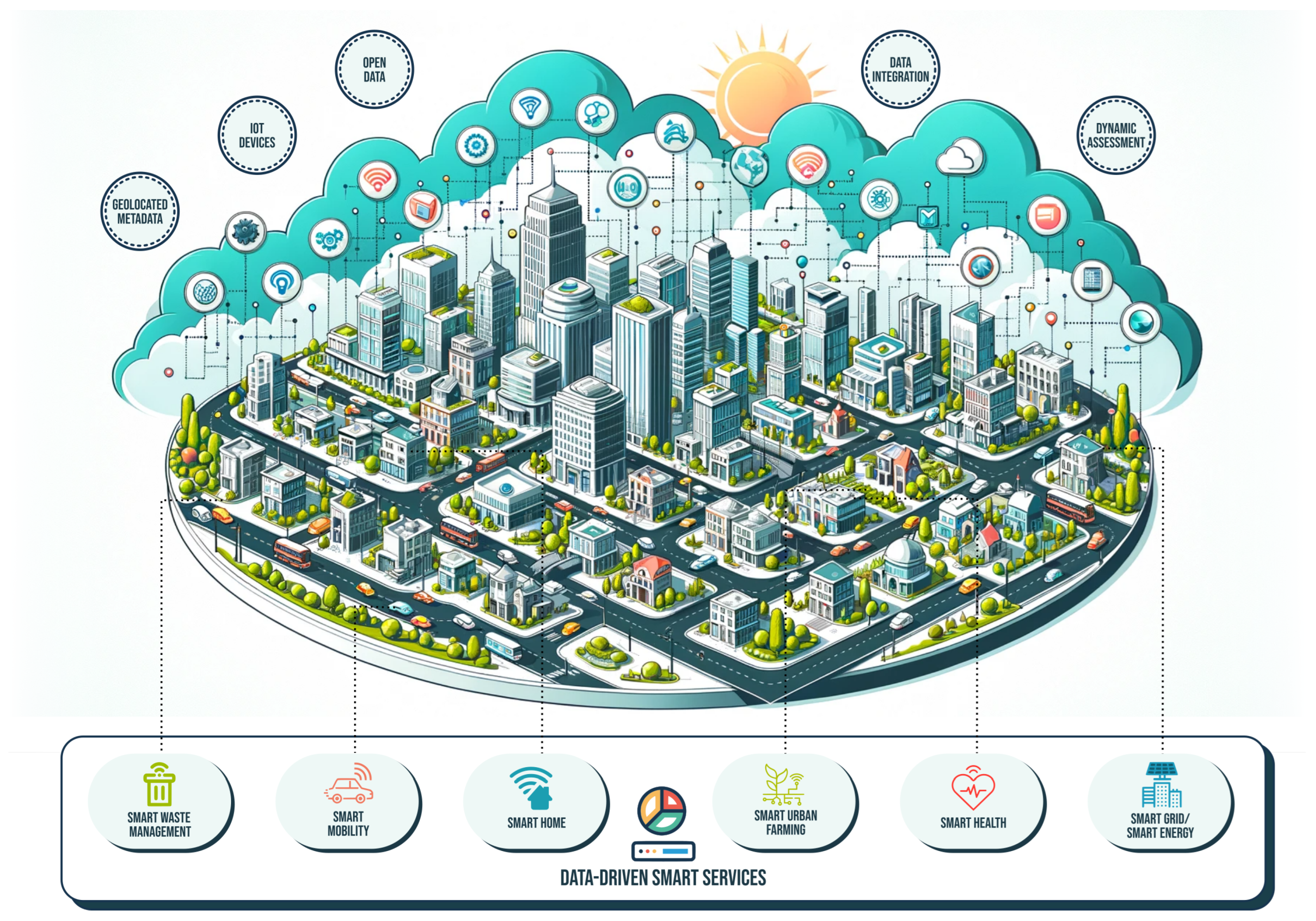
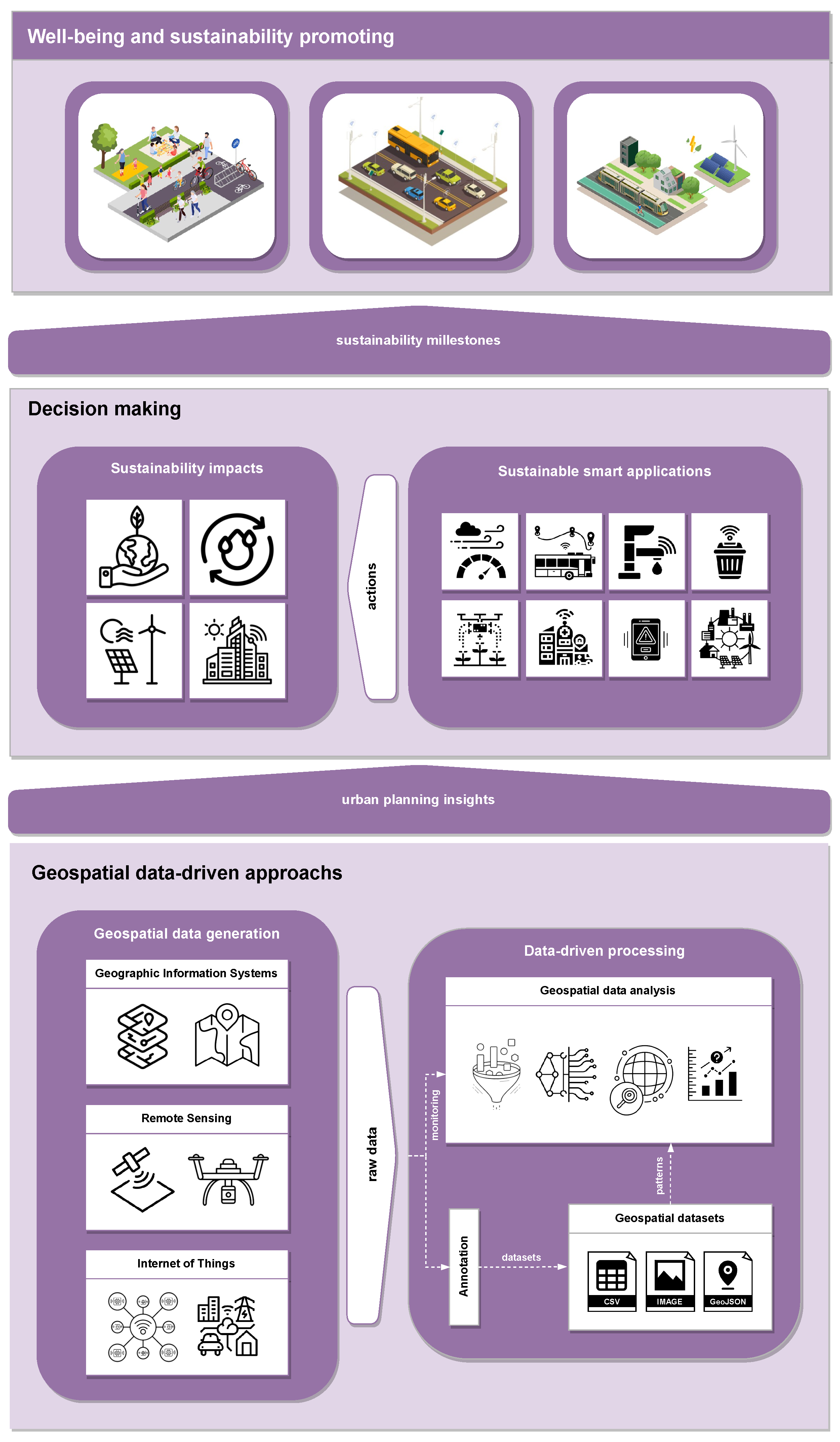
2. Smart Cities and Sustainability

A smart city is an urban environment that optimizes resource utilization to enhance the quality of life for its residents. This is commonly accomplished through advanced technologies that enable the optimization of city operations and the addressing of various challenges associated with urban living. For that, these cities leverage information and communication technologies to collect and analyze data, facilitating informed decisions to improve efficiency, sustainability, and overall well-being. Moreover, smart cities offer digital solutions across various domains such as transportation, energy, healthcare, governance, and public services, creating an interconnected and intelligent urban ecosystem [15]. Therefore, providing long-term viability for these cities is essential, notably through the integration of sustainability principles, accomplished via innovative data-driven strategies.
In the context of smart cities, sustainability refers to the capability of the urban environment as a whole to “execute” actions and deploy technologies for its ongoing development while preserving and enduring its resources over the long term while not imposing substantial adverse impacts on the environment, society, or economy. It entails meeting present needs without compromising the ability of future generations to fulfill their own demands. The creation and development of sustainable cities and communities align with one of the United Nations’ sustainable development goals (SDG 11). However, the potential for achieving sustainability through smart-city solutions extends beyond this goal. Smart cities can be intricately designed to actively contribute to harmonious coexistence between human activities and the natural world, embracing practices and policies that balance three pillars: environmental conservation, social equity, and economic viability [16,17]. Table 1 illustrates the 17 SDGs of the United Nations, categorizing the domains they address, which can be directly influenced by smart-city solutions.
Therefore, to attain sustainability in smart cities (SDG 11), it is necessary to tackle various challenges that emerge from the complex and dynamic interactions between the urban environment and its stakeholders. These challenges align with the sustainability pillars, covering a range of issues and aspects that require careful consideration and proactive measures. The discussions in this article delve into some of the most relevant and pressing challenges within each category, elucidating how geospatial data-driven approaches can help to overcome them. Since geospatial data-driven approaches will rely on geospatial data and associated technologies, they may provide valuable insights for the integration and optimization of smart-city solutions, enhancing their expected sustainability outcomes and facilitating the assessment and feedback of the impacts associated with these solutions.
Concerning the environmental challenges faced by sustainable smart cities, a primary consideration is the adoption of alternative energies that can diminish reliance on fossil fuels and lower greenhouse gas emissions. Examples of alternative energies encompass solar, wind, hydro, geothermal, and biomass sources, offering clean and renewable power for a variety of urban applications [18]. However, these sources also pose some challenges, such as high initial costs, intermittency, storage, and grid integration. Smart cities must invest in innovative solutions to surpass these barriers and ensure a reliable and efficient alternative energy supply. For instance, smart grids can use advanced sensors, communication, and control systems to manage the demand and supply of electricity, integrating various distributed energy sources and enabling demand response and load shifting [19]. Geospatial data-driven approaches can support the planning and operation of smart grids by providing spatial and temporal information on the availability and potential of alternative energy resources, the location and characteristics of energy infrastructure and consumers, and the environmental and social impacts of energy production and consumption [20].
Another environmental challenge is the reduction of the use of private motorized vehicles. This can contribute to lower air pollution, noise, congestion, and accidents. Smart cities can promote sustainable mobility by implementing policies and employing technologies that encourage the use of public transportation, cycling, walking, and shared mobility services. These modes of transport can reduce the environmental and social impacts of urban mobility, as well as improve the health and well-being of citizens. Smart cities can also leverage intelligent transportation systems that monitor and optimize traffic flows, provide real-time information and guidance to travelers, and implement dynamic pricing and incentives to influence travel behavior [21,22]. Geospatial data-driven approaches can enable the development and deployment of such intelligent transportation systems by collecting and analyzing data on the location, speed, and direction of vehicles and travelers, the road network and traffic conditions, the availability and accessibility of transport modes and services, and the travel patterns and preferences of citizens.
Sustainable smart cities must also deal with preserving ecosystems in an environmental sphere. Ecosystems provide essential services and benefits for human well-being, such as water purification, climate regulation, biodiversity, and recreation. Smart cities must protect and restore the natural environment within and around the urban area, ensuring the conservation of land, water, and biological resources [23]. Actually, smart cities can use geospatial data and technologies to map and monitor the state and trends of ecosystems, assess their values, functions, and significance for human well-being, and identify causes of changes and external influences that affect them. This can help smart cities design and implement effective strategies and actions to enhance the resilience and sustainability of ecosystems, embracing approaches like green infrastructure, ecosystem-based adaptation, and nature-based solutions [24].
Smart cities also face numerous challenges related to economic aspects in their pursuit of sustainability, especially the substantial upfront cost associated with implementing smart infrastructures. Deploying interconnected systems, such as Internet of Things (IoT) devices, intelligent transportation, and energy-efficient solutions, demands a considerable initial investment [25,26]. Cities must navigate budget constraints and explore financing models to fund these initiatives, striking a balance between short-term financial pressures and long-term sustainability goals—a delicate challenge for city planners and policymakers. However, in addressing these economic complexities, smart cities can leverage geospatial data-driven smart approaches. In general, geospatial data, encompassing information tied to specific geographic locations, becomes a powerful tool for optimizing resource allocation and infrastructure planning. In terms of upfront costs, geospatial data enables cities to conduct precise spatial analyses, identifying optimal locations for the deployment of smart infrastructure. This targeted approach not only helps minimize initial investment by focusing on high-impact areas but also enhances the efficiency and effectiveness of resource utilization, contributing to long-term economic sustainability.
As the deployment cost is an issue in sustainable smart cities, it is equally important to deal with the cost of managing obsolete technologies, which necessitates adaptive strategies, balancing the economic viability of innovation with the imperative for a stable urban ecosystem. Cities must continuously evaluate and strategically plan the integration of emerging technologies and effectively address the environmental impact and costs associated with dealing with outdated systems [27,28]. In this context, collaborative efforts between the public and private sectors become imperative to ensure the economic viability and environmental resilience of smart-city initiatives. Thus, geospatial data are essential to the spatial intelligence necessary to overcome financial challenges posed by obsolete technologies and forge a sustainable urban future. Through continuous updates and real-time integration, cities can adapt their smart infrastructure to evolving technological landscapes, enabling agile and responsive decision-making. Geospatial data-driven strategies help ensure that investments remain relevant by integrating emerging technologies into the urban fabric and promoting a harmonious balance between economic viability and environmental sustainability.
The economic sustainability of smart cities is intricately associated with issues of inclusiveness and accessibility. The deployment of cutting-edge technologies, if not implemented thoughtfully, may inadvertently exacerbate existing social and economic disparities [29]. Factors such as income inequality or technological literacy can limit access to digital services like smart transportation or e-governance platforms for certain demographic groups. Achieving economic and social sustainability in smart cities requires proactive measures to ensure equitable distribution of the positive impact of technological advancements, fostering an inclusive urban environment where all residents can participate in and benefit from the innovations brought about by smart-city initiatives [30]. In this context, geospatial data can be used to map socio-economic indicators against geographic locations, while city planners can identify areas with limited access to smart services and formulate targeted interventions. Geospatial analysis facilitates the identification of digital divides, ensuring that smart-city initiatives are strategically implemented to bridge these gaps.
Still addressing the social challenges for achieving sustainability in smart cities, an important aspect involves thoroughly analyzing citizens’ culture and habits. These aspects significantly influence the acceptance and adoption of smart-city technologies and practices. Culture and habits encompass the norms, values, beliefs, and behaviors that shape how individuals interact with their surroundings and with each other. Since smart cities must comprehend and respect such a diverse and intricate nature, the design of smart-city solutions should also align with and be adaptable to their needs, preferences, and expectations.
Additionally, promoting a culture of innovation and learning among citizens is essential, encouraging them to experiment, explore, and embrace new and improved ways of urban living [31,32,33]. Geospatial data-driven approaches emerge as valuable tools aimed at understanding and influencing the culture and habits of citizens. By capturing and analyzing data on the spatial and temporal distribution and dynamics of urban activities and behaviors, these approaches identify and address the needs and problems of different groups and communities and provide feedback and incentives to motivate and reward positive changes and actions [33,34].
In this social context, ensuring active and meaningful citizen participation in planning, developing, and managing smart-city initiatives is imperative. Such involvement not only enhances the quality and effectiveness of smart-city solutions but also contributes to the satisfaction and well-being of the inhabitants by ensuring that these solutions genuinely address the real needs and issues of the urban community. Smart cities can employ various methods and tools to encourage and support citizen participation, including surveys, workshops, focus groups, crowdsourcing, gamification, and social media [33]. These mechanisms empower individuals to freely express their opinions, ideas, and feedback, as well as to collaborate in the co-design, co-production, and co-evaluation of smart-city solutions. The efficacy of these approaches is significantly augmented when associated with geospatial information, enabling a more comprehensive understanding of the geographical needs of citizens. This enriched understanding, in turn, enables more precise and tailored solutions that align with the specific spatial requirements of the community [35].
In conclusion, the quest to build sustainable smart cities demands a comprehensive understanding and integration of diverse aspects across environmental, economic, and social domains. By aligning with the United Nations’ sustainable development goals, smart cities can act as catalysts for positive change, addressing challenges and promoting a symbiotic relationship between human activities and the natural environment. The intricate nature of these challenges necessitates innovative strategies, particularly through data-driven approaches and geospatial insights. These methods should serve as a reference for smart cities, providing the spatial intelligence necessary to overcome economic hurdles and forge a sustainable urban future. In the upcoming sections, we delve into the applications and positive impacts of data-driven urban processing, discussing smart-city approaches that will shape the trajectory of achieving more sustainable smart cities.
An illustrative example of how all the aforementioned sustainability goals can be pursued when developing smart cities can be seen in Figure 1. Some common smart-city services are highlighted, as well as the general idea of geospatial data that will support them. Actually, as discussed in this section, we believe that a healthy smart-city scenario will encompass economic sustainability, efficient technology management, social equality, citizen participation, and climate change preparedness.

3. Geospatial Urban Data Processing

To achieve urban sustainability in a broader sense, new smart approaches must be sought and developed. Every aspect of a city can be considered a potential improvement possibility, taking advantage of new technologies available at the time. In this sense, extensive research must be conducted to discover and develop proper approaches to enhance public services in cities and achieve the desirable level of sustainability. However, studying a city is a complex task that cannot be confined to a laboratory or a desk. Such a research object must be translated into a more practical mechanism that can be studied without the hassle of having to go to every corner of the city, revealing a situation in which modeling tools are highly demanded. Using data-driven methodologies, city models can be developed to help understand this complex environment.
A model represents a real system by omitting irrelevant details and retaining only those attributes that are relevant or important to the proposed study or work [36]. In the context of smart cities, features such as roads, response centers, public facilities, rivers, public parks, relief, and slopes, among others, are relevant and can be modeled properly according to the desired perspective. Tools that include maps, geological representations, and 3D objects are examples of models that can be used to represent real research objects, which are valuable in the research and development phases of smart-city initiatives [37].
To model a city and all its complexities at different levels, different tools and data sources are required, depending on the type of smart-city services being pursued. In terms of how data are produced and processed, three approaches stand out: Geographic Information Systems (GIS), Remote Sensing, and IoT-based sensing. All these basic elements are crucial for the production and management of geospatial data, which can support the operation of smart-city applications or be stored as georeferenced datasets (addressed in Section 4). The following subsections discuss these approaches in more detail as they define some of the foundations for data-driven smart cities.

3.1. Geographic Information Systems

Geographic information systems are responsible for retrieving, storing, manipulating, and analyzing georeferenced data to support the study of a research object as a geographical area [38]. GIS can be used to model and study any georeferenced region, from small areas such as rural villages and towns to entire countries. They can also be applied in various contexts, such as resource mining [39], disease prediction [40], traffic analysis [41], risk assessment [42], and many others. In this sense, several smart-city initiatives have relied on GIS to improve their perception of the urban environment [43].
In a typical geographic information system, data must be georeferenced. In other words, all relevant data must be associated with its coordinates (latitude and longitude) and, in some cases, its altitude [44]. For example, when modeling the location of hospitals in a city for emergency planning purposes, the coordinates of the hospitals must be known to constitute georeferenced data. By their very nature, georeferenced data can be obtained from different sources, either private or public, which has a direct impact on the way in which such data are used in practical applications [45].
GIS-based data are being used to forecast, calculate, and visualize land use in cities, supporting the development of frameworks that can identify patterns in the consumption of utility infrastructure (water, sewerage, energy, etc.) and help city planners and managers make informed decisions [46]. However, this is just one facet of GIS tools in smart cities. Using IoT to access real-time city traffic, GIS can support the development of dynamic transport networks to improve performance and reduce the cost of distribution services [47]. In addition, less traffic means lower gas emissions, as internal combustion engine vehicles still dominate the global market [48], making traffic reduction a major challenge in creating more sustainable cities. In this context, GIS tools can leverage research on traffic-related air pollution to assess air quality and its impact on citizens’ health [49], with significant results.
Governance is crucial for sustainable development and cannot be neglected in smart cities [50]. The establishment of sustainable urban spaces can be supported by GIS tools and geo-questionnaires to improve the quality of life in a city by increasing citizen participation [51]. GIS and citizen participation also play an important role in the planning of sustainable transport systems, promoting the discussion of social conflicts in the implementation phases [52].
Finally, the versatility of GIS data and tools can also benefit emergency management in smart cities, tackling natural hazards such as floods [53], fires [54], hurricanes [55], and many other critical situations. Not only natural emergencies can be tackled with GIS data, but also different types of human-induced emergencies, such as industrial explosions and car accidents, can be supported with georeferenced data, helping to improve safety in smart cities [56].
Nevertheless, it is natural to expect that many data-driven smart cities will rely on GIS as a core element in this aspect. A promising generic tool is the Quantum Geographic Information System (QGIS), a popular GIS tool that supports different types of geospatial analyses depending on the available geospatial data [57]. With the recent emergence of many open-access GIS tools with specialized processing features [43,58,59], data-driven smart cities gain an important ally in better understanding the urban characteristics of each target city.
As a final remark, it is reasonable to say that GIS plays a crucial role in contributing to the sustainable development of cities by providing spatial intelligence and analytical tools. Since the processed data and performed analyses may be too versatile, GIS can be extensively used when approaching economic sustainability, environmental challenges, sustainable technologies management, social equality promotion, and citizen participation. Such issues are further discussed in Section 5.

3.2. Remote Sensing

When modeling large areas, data on the land and terrain within a city may also be relevant in many cases. With rapid urbanization and city sprawl worldwide, land cover is changing rapidly, making some data obsolete in the short term [60]. Therefore, the accuracy of a city’s land use and land cover data cannot be neglected when developing sustainable smart-city initiatives. In fact, land cover and land-use data have proven to be highly relevant, and many approaches use them as input for different processing tasks [61,62,63,64].
Land cover, land use, and related data can be obtained using remote sensing techniques. It can be carried out both actively, using radars and LiDAR (Light Detection and Ranging) equipment by emitting a radio frequency signal and measuring the response, and passively, using satellites equipped with sensors that collect the reflected multi-spectral radio frequency from the Earth’s surface [65]. Satellite multi-spectral data such as RGB imagery, infrared reflectance, aerosols, and others can be obtained from the Sentinel-2 and Landsat satellites, both of which are open and freely available through the Google Earth Engine platform [66]. These data are paramount in several smart sustainability initiatives such as urban heat island analysis [67], traffic speed monitoring [68], and urban sprawl assessment [69].
Remote sensing can be used with other technologies and approaches to improve data analysis. With the widespread adoption of social media by citizens, remote sensing data are being integrated with social media data for urban observation, enabling the study of the relationship between people and the urban environments, therefore promoting better urban planning for a sustainable city [70]. The Big Data paradigm is also being combined with remote sensing technology, enhancing the application value of remote sensing and promoting initiatives on urban pollution, planning, traffic intelligence, and other promising approaches for sustainable cities [71].
The analysis of the morphology of cities can also benefit from remote sensing data, assisting in urban management and guiding its sustainable development. In this direction, several machine-learning approaches make use of remote sensing in building structure mapping [72], satellite image enhancement for urban area feature recognition [73], and house vacancy detection [74]. These approaches can ultimately promote more sustainable urban planning while assisting public managers in improving the quality of life in urban environments.
In general, the adoption of remote sensing to promote sustainable urban development brings both opportunities and challenges. Addressing the aforementioned sustainability issues involves a comprehensive and ethical approach that ensures the technology’s benefits are shared equitably, respects privacy, integrates local knowledge, and contributes to resilient and inclusive urban environments. This is in line with the expected objectives when designing data-driven smart cities, with remote sensing being adopted as a game changer and not as a tool to reinforce spatial urban inequalities.

3.3. IoT-Based Sensing

IoT-based sensing has been used in smart-city initiatives for several years, defining a wide range of urban sensing methodologies [75]. For sustainable smart-city development, all types of data about the metropolitan area, its buildings, infrastructure, and inhabitants are relevant for developing technological approaches and systems that use urban planning to improve city services. Combined with Big Data solutions, IoT sensors can provide a complete data set as an algorithm input, producing relevant information for public managers [76]. To this end, IoT sensors are expected to be equipped with a GPS receiver to geo-locate the sensing unit, adding coordinates and producing meaningful georeferenced data for data-driven smart cities.
Since IoT devices can generate large amounts of data, appropriate storage mechanisms must be employed for data persistence, and cloud computing can be used to manage IoT-generated data and enable further processing to generate valuable information about the city [77]. In this way, the “Cloud of Things” paradigm enriches IoT applications with cloud-based solutions, providing multiple approaches for sustainable smart-city development [78]. As a result, cloud-based IoT solutions are being used in sustainable smart cities for monitoring transportation networks [79], water supply systems [80], crime detection [81], and many other vital smart-city systems. With the advanced development of artificial intelligence algorithms and models, data from IoT devices can be processed and used in various applications [82], potentially leading to the improvement of many systems in this scenario [83,84,85].
The governance of cities can also benefit from IoT data, providing more efficient management for residents and improving public services [86]. In this sense, government agencies are having their performance monitored by IoT-sensed data [87]. In addition, the large number of entities providing services to citizens poses another challenge to smart-city management, requiring intelligent management approaches that can be achieved with IoT data [88]. By converging governance with IoT data, smart-city management can be effectively achieved, enabling the development of smarter and more sustainable cities [89].
Another promising trend in smart cities is the use of georeferenced IoT-based drones to provide different types of data. Due to their mobility and operational flexibility, drones can help provide critical data in a timely manner, adding an important layer of geospatial data for a better understanding of urban environments [90,91].
Still considering the generation of georeferenced data, even without an inherent relation to the IoT paradigm, crowdsensing has been adopted as an effective way to retrieve important data on different urban dynamics, also contributing to a better perception of cities. Taking advantage of smartphones and wearables, such approaches can also make important contributions, especially when the retrieved data are openly accessible through smart-city approaches [92]. Furthermore, crowdsourced data complements the specialized datasets obtained from IoT sensors on the ground, providing a human-centered perspective. Data collected from smart devices enables an understanding of community engagement and real-time urban dynamics, including traffic patterns and local events, enhancing geospatial datasets with valuable ground-level insights [92,93].
Finally, the expected scenario is a rich combination of GIS, remote sensing, and IoT sensors employed to provide data and support its proper processing. Figure 2 shows the same urban area of the city of Porto, Portugal, highlighting different uses of georeferenced data. Actually, when properly implemented and managed, all these three resources will be fundamental when pursuing more sustainable urban development backed by smart-city approaches.

4. Geospatial Datasets and Management of Georeferenced Data

As cities expand and face complex challenges, efficient data management has become increasingly important in the evolving urban landscape. Geospatial datasets play an essential role in this regard, taking advantage of modern geospatial data analysis technologies to improve our ability to comprehend and manage urban environments [96]. Furthermore, leveraging technologies such as the IoT, Big Data, and cloud computing highlights their importance in driving urban innovation [97]. In this context, integrating urban datasets with geospatial information is essential to provide spatially informed analysis that supports disaster management, urban growth management, and sustainable planning [98,99]. This section delves into integrating these various data sources employed in data-driven smart cities, discussing some of the currently targeted datasets that have supported sustainable solutions.

4.1. Integrating Geospatial Data for Smart Cities

Geospatial datasets provide localized, context-based information, which is essential for effectively addressing urban issues. Incorporating location metadata enriches this information, allowing it to combine several urban datasets to provide a better understanding of the urban landscape. These metadata range from precise latitude and longitude coordinates to broader contexts such as district names or neighborhoods. Such enriched data facilitates informed decision-making by revealing patterns and trends, therefore leading to local interventions that improve the quality of life of city residents.
However, the accuracy and depth of geospatial data are critical for making well-informed decisions in urban areas [97]. Informed geospatial datasets must provide insights into different aspects of urban life, from mobility to health, disaster risk management, education, and security [100,101,102,103,104]. In this way, the integration of geospatial data within a smart-city framework can enhance the adaptability and resilience of cities and support sustainability goals for the development of innovative urban management solutions [105,106,107]. As we delve into the multifaceted domain of sustainable cities, the importance of comprehensively understanding, managing, and using geospatial datasets becomes clear. These datasets are expected to form the cornerstone of future sustainable cities, exceeding their role as primary collections of spatial coordinates and features.
Understanding the diversity of geospatial data types is fundamental to the pursuit of sustainable development within smart cities. Each data type has unique attributes and contributes to the comprehensive understanding and management of urban environments. Initially, considering the relevance of remote sensing for urban analyses, satellite imagery constitutes a notable component of geospatial data that will often be adopted by data-driven smart cities. Such data offer comprehensive panoramic views of the surface, capturing large-scale changes in land use, urban spread, and ecological conditions over time [101]. The significance of satellite imagery lies in its capability to provide a broad perspective that is essential for sustainable long-term planning and urban development initiatives. For example, an aerial perspective can be used for developing environmental conservation and city planning projects [108]. By providing data georeferencing, the images can support predictive models and simulations that open a window into the future of smart cities [109,110]. In this sense, such information facilitates urban planners’ preparation for future circumstances and helps them preempt potential issues, aiding when mitigating anticipated large environmental impacts and managing resources more efficiently.
Complementing this macroscopic perspective is the real-time data collected by IoT sensors. These units are composed of scalar or multimedia sensors distributed across a target area, providing in-depth assessments by monitoring environmental and urban elements such as air quality, noise levels, emergency risks, and energy consumption [9,97]. In fact, IoT sensors’ spatial proximity and specificity facilitate agile decision-making and effective short-term urban management, addressing challenges such as pollution control, energy efficiency, and urban safety [9,111,112]. Similar conclusions can be drawn when considering crowdsensing approaches since incorporating location metadata can transform crowdsourced data into valuable insights for urban planners, enabling more localized strategies and leading to increased effectiveness and efficiency in urban development.
Forming the structural backbone of geospatial datasets, infrastructure maps describe the physical layout of the city, including roads, buildings, and services. These maps deliver information aimed at urban spatial planning, aiding in identifying areas that need infrastructure enhancements or conservation and policy interventions [113,114]. These maps are also strategic for managing the development and transformation of cities in line with sustainable goals, including climate change, mobility transition, and resilience [115,116].
In addition to the beneficial insights offered by the infrastructure maps, historical events with geolocation metadata enable urban planners to learn from past experiences through a retrospective viewpoint [117]. In doing so, these datasets provide valuable lessons for future sustainability planning when examining the impacts of natural disasters and reviewing the findings of prior urban development initiatives [118,119]. Notably, such data can assist in identifying recurring patterns and trends, leading to more informed and resilient urban planning decisions. For example, it can be leveraged to assess urban risk areas based on past disasters, such as floods and landslides. Additionally, these datasets can carry information regarding historic mobility trends, providing information that can be used when developing prediction models.
Finally, datasets depicting network availability, including public Wi-Fi hotspots, mobile network coverage, and other connectivity infrastructure, have recently gained momentum in geospatial analysis for smart cities [120,121,122,123]. Although often overlooked, these datasets provide valuable information that can enhance urban sustainability and the functionality of smart cities. Network availability data uncovers the connectivity proficiency of urban areas by identifying regions with robust network services and those that may be under-served [122]. It is important to highlight that connectivity forms the basis for services and applications in smart cities. By leveraging these data, city planners can identify strategic locations for new hotspots, therefore increasing digital inclusion. Likewise, data on mobile network coverage can inform the deployment of IoT devices and sensors, ensuring their placement in areas with sufficient connectivity for data transmission [124].

4.2. Data Sources and Accessibility

In the evolution of smart cities, the accessibility of geospatial data sources is as important as the data itself. Therefore, the efficiency of urban planning and sustainable efforts heavily relies on both the diversity of these sources and the levels of accessibility they can provide [125]. In this sense, governmental and public sector agencies are the primary sources of geospatial data. These entities possess valuable information about public services, the environment, commercial, security, mobility, and even real-time data collected by IoT sensors spread throughout the city. Making these data readily available promotes transparency and encourages participation in urban development processes. Actually, several cities are adopting the so-called “Open-Data” initiative based on the potential value generated by reusing public datasets [126,127,128]. If adopted on a large scale and consistently, these initiatives can harness the sustainable development of open-data platforms and adopt a holistic and transversal vision for the city.
Nevertheless, the accessibility of such data varies from region to region and is subject to the policies of the governing bodies [129]. For example, data privacy laws can limit the accessibility to urban datasets, potentially affecting the accuracy and completeness of the system using those data. Data storage availability could also impact the quality of the analysis. In regions where data collection and storage infrastructure may be lacking, data could have limited availability, impacting the quality of research or related analyses. This variation in data availability could lead to biased conclusions and limited generalization of findings, as the data may not provide a complete picture of the phenomenon under investigation.
The private sector also plays a significant role in producing georeferenced data, particularly from IoT devices and telecommunications [130]. Private entities can provide detailed and frequently updated data, but this often comes with access restrictions and costs, which can limit its use for public purposes. In this scenario, collaborative partnerships between the public and private sectors can help overcome these obstacles, facilitating a more extensive and consistent approach towards sustainable smart-city services development. Such partnerships can enable the effective use of technologies and innovative ideas to create more resilient, equitable, and sustainable environments [34,131]. Thus, developing public-private collaborations offers a promising avenue for advancing the sustainable development agenda and improving the quality of life for urban residents.
On the other hand, community-based platforms have emerged as contributors to the pool of geospatial data sources. These platforms are generally available online and accessible to anyone with an internet connection. Such platforms allow users to contribute to or extract information from them through interfaces or APIs (Application Programming Interfaces) designed to be easy to use [132]. This ease of access has resulted in widespread participation, leading to diverse databases with richer data. The information on such platforms is usually crowdsourced and covers geospatial information, ranging from real-time traffic updates to environmental or urban spatial observations [92,114]. In this scenario, the OpenStreetMap (OSM) stands out as one of the noteworthy geospatial source platforms available presently, being largely used by researchers worldwide [133]. OSM uses georeferenced parameters to represent real-world physical features like roads and buildings, along with their associated metadata. However, while profiting from open access, the dependability of these data sources can vary, requiring stringent verification and regulations to guarantee their accuracy and reliability.
Despite the richness of these data sources, accessing a comprehensive, integrated set of geospatial datasets for urban planning remains a significant challenge [134]. Limited data containers, lack of standard formats, source integration, and privacy concerns limit practical data usability. Initiatives to enhance data accessibility are underway, focusing on research and government open-data repositories that employ standard formats for distributing geospatial data, including text files, Comma-separated Values (CSV), and JavaScript Object Notation (JSON) [135,136], among other formats. More recently, the GeoJSON file format introduced an encoding standard for geographic data structures by supporting geometry types and geometric objects. Additionally, the General Transit Feed Specification (GTFS) format allows the distribution of relevant metadata on mobility systems. This format can include both schedule information about routes and geographic transit details and real-time data such as trip updates and vehicle positions. Finally, the ShapeFile format is still popular in GIS tools because it stores non-topological geometry and attributes information for spatial features. This information usually consists of points, lines, and polygons that can be used to facilitate georeferenced data visualization. These standardization initiatives aim to enhance the sharing and interoperability among datasets, therefore improving their benefits for urban planning. Since this trend has moved towards standard open-data policies, particularly in the public sector, it presents a potential opportunity to unlock the deployment of large and comprehensive urban datasets.

4.3. Datasets for Sustainability in Smart Cities

Integrating multiple geospatial data types is fundamental to creating comprehensive, multi-dimensional datasets for promoting sustainability in smart cities. By combining these distinct perspectives in a data-driven approach, researchers, urban planners, and policymakers can formulate more resilient and sustainable planning strategies. This holistic approach is essential for tackling the present and future hurdles of urban growth, guaranteeing the progress of intelligent cities in an inventive and sustainable way.
As well as open-data initiatives, several datasets have been developed in the literature to support sustainability efforts in the domain of data-driven smart cities. These data collections offer crucial insights and information to aid cities in addressing their unique challenges. In this sense, Table 2 outlines a comprehensive summary of some of the datasets that can be employed to foster the development of sustainable and resilient cities. These datasets converge to form an integrated approach to addressing the multifaceted challenges of urban environments.
Central to this integration is the utilization of multi-source urban datasets [137]. These compilations combine multiple urban data streams to provide a comprehensive view essential for developing innovative and integrated solutions. However, such diverse data sources depend heavily on advanced integration techniques and managing inherent complexities [98,99], which makes geospatial data integration an ongoing challenge. Common obstacles toward effective multi-source data management include redundancy and lack of harmonization due to different source standards (e.g., figures and text files) [107].
In a more targeted approach, urban infrastructure management can benefit from visual datasets obtained from smart cameras that demonstrate the practical use of IoT technology [139]. Such datasets prioritize scalability and maintenance, which requires integration with broader urban systems, therefore improving efficiency and promoting advanced applications. In general, datasets composed of images captured from cameras distributed along the city may be used for different purposes, for example, when multimedia data from traffic monitoring cameras are exploited to both evaluate road speed data and assess pedestrian traffic over time.
Datasets that target natural disaster indicators [138] fill an indispensable gap in disaster risk management, providing urban planners with risk assessment and emergency preparedness mechanisms [9]. Although valuable in constructing urban resilience, it is essential to continually update and customize these datasets to maintain their relevance and accuracy. Predictive modeling using this type of data opens up opportunities for preemptive disaster risk assessment. Similarly, datasets regarding the ability of city infrastructure to respond to critical situations are pivotal for developing effective emergency management systems [45]. These datasets contribute to a deeper comprehension of regional development concerning hazard resilience, empowering planners to anticipate critical scenarios and prepare cities to mitigate risks and enhance safety. However, comprehensive coverage and rapid updating capabilities are still essential to allow for more dynamic datasets to be developed.
In the context of mitigating environmental impacts, datasets on urban parameters are of paramount importance [140]. By ensuring data accuracy and timeliness, it becomes possible to perform predictive analyses that can lead to targeted environment management [102,144]. In fact, efficient adaptation to changing environmental conditions is possible for cities through real-time monitoring and the development of cognitive models. Such improvements are directly related to the efficient management of green space classification [142] and to support land-use impact assessments [10,15]. Both aspects are crucial for sustainable land use and biodiversity, underlining the role of ecological balance in urban areas. Nevertheless, accurately mapping and assessing green spaces remain challenging, with community-driven planning processes being one of the most prominent solutions.
Emphasizing the importance of crowdsourced archives, datasets of cultural and creative sites contribute to protecting cultural and natural heritage [143]. These collections usually leverage infrastructure maps from OpenStreetMap, along with information collected from the public sector, such as universities and government entities. This highlights the need to promote the accessibility and interoperability of such information for properly managing and preserving cultural assets [145].
Evaluating the infrastructure of wireless networks in urban settings highlights the significance of robust digital infrastructure for the sustainable development of smart cities [120]. This information can support and improve the reach and effectiveness of city services, such as mobility, energy, security, and health [115,121]. Furthermore, it can analyze the unequal connectivity distribution throughout different urban areas [122,146]. Advances in this direction can bridge digital inequality and reflect the growing digital demands of modern cities, thus aligning with sustainable urban goals.
Research into geospatial datasets to support smart cities has highlighted their intrinsic value in urban management and planning. Rich and diverse datasets provide more than just static information; they are dynamic tools that fundamentally improve urban life. By seamlessly integrating them into different urban systems, their true potential unfolds in practical applications. Geospatial data proves to be pivotal in optimizing urban infrastructure and enhancing environmental monitoring. Integrating geospatial data in practical scenarios exemplifies smart-city development, transforming theoretical concepts into tangible solutions while addressing real-world urban challenges. In this sense, data-driven insights are actively used to foster responsive, efficient, and sustainable urban ecosystems. The multi-disciplinary nature of these datasets reflects the evolving nature of different smart-city applications, where data are collected and actively used to shape the future of urban landscapes, as discussed in the next section.

5. Sustainable Smart-City Applications

In smart cities, geospatial data plays a fundamental role in the design and implementation of urban services focused on sustainability. The application of data-driven approaches in urban management allows for a deeper and more comprehensive understanding of the specific challenges and opportunities in each locality [14]. By integrating geospatial information such as traffic data, air quality, land use, and infrastructure, cities can make informed and strategic decisions to optimize resources, reduce environmental impacts, and improve the quality of life for citizens [147]. Such an approach not only enables more efficient administration but also contributes to the creation of urban environments that are more sustainable, resilient, and adaptable to the dynamic needs of local communities. The intersection between geospatial data and data-driven urban services is, therefore, crucial for cities that prioritize sustainability at their core [3].
Thus, for the development of sustainable smart cities, it is imperative to adhere to a data collection flow through GIS, IoT applications, and remote sensing techniques [148]. The raw data gathered from these sources drives the processing stage, which is based on data-driven approaches using techniques such as machine learning, descriptive statistics, time series analysis, natural language processing, and data visualization [11]. These methods facilitate the generation of valuable information that provides essential insights for more efficient and sustainable urban planning, as illustrated in Figure 3.
The insights gained from processing geospatial data through data-driven approaches not only enable more effective urban planning but also provide governments with valuable tools for strategic decision-making. As such, this information is critical to the design and implementation of sustainable smart applications, covering various areas related to improving the quality of life in smart cities. Examples of these applications include [3]:
  • Pollution monitoring: using data to monitor and reduce air and water pollution and promote healthier urban environments;
  • Smart urban mobility: implementing data-driven solutions to optimize traffic, support public transport, and promote sustainable mobility options;
  • Efficient water management: using insights to improve water resource management, reduce waste and ensure equitable access to clean water;
  • Sustainable waste management: applying technologies to monitor, collect, and sustainably manage waste, therefore contributing to the reduction of environmental impacts;
  • Smart urban farming: the use of geospatially enabled agricultural practices to increase efficiency, reduce resource use, and promote sustainable agriculture;
  • Smart health: leveraging data to monitor health indicators, prevent disease, and improve the quality of health services in the city;
  • Emergency management: integrating policies and technologies to assess, monitor, and respond to disaster risks, therefore increasing urban resilience;
  • Smart grids: incorporating advanced technologies to optimize energy distribution, increase efficiency, and promote renewable energy sources.
In summary, smart applications go beyond the mere transformation of the urban landscape; they establish robust milestones for sustainability, with a direct impact on the quality of life of residents and the preservation of the planet, which is in line with the aforementioned UN Sustainable Development Goals numbers 3, 6, 7, 9, 11, 12 and 13 (Table 1). These solutions not only promote more efficient, healthy, and resilient urban environments but also consolidate smart cities as protagonists in mitigating environmental damage, thus playing a crucial role in addressing climate challenges, including the growing concern over global warming [149].

5.1. Reviewing Data-Driven Smart-City Approaches

Currently, academic research is strategically oriented towards sustainable goals, which is an essential response to the current scenario of rapid global climate change that drives the need for innovative and sustainable solutions. This growing momentum towards sustainability underlines the importance of conducting a comprehensive survey of the research works that have exploited geospatial data and data-driven approaches [150].
A survey of the literature was conducted for the period between 2019 and 2023 in the following databases: IEEE Xplore, Springer Link, ScienceDirect, ACM Digital Library, and MDPI. The search was based on the following keywords: “sustainable smart cities”, “geospatial data”, “data-driven approaches”, “internet of things”, “remote sensing”, and “geographic information systems”. From this initial search, 152 articles were identified and selected. After a final review based on content and practical results, a total of 15 articles were selected and summarized in Table 3.
The literature review reveals a significant number of studies, with a particular focus on risk analysis and resource management. Of the 15 highlighted papers, most of them focus on these critical areas, highlighting the key role of geospatial technologies in better understanding the urban environment. Indeed, innovative technologies such as GIS and IoT are emerging as protagonists in this context.
Furthermore, the consistent presence of Machine-Learning (ML) applications in various research works underlines the rise of these techniques in the digital transformation of urban planning. For example, in [157], the efficient management of water distribution networks is enhanced by predictive analyses supported by ML techniques. These approaches not only provide valuable insights but also demonstrate the ability to anticipate complex challenges and shape the future of sustainable urban management.
Finally, the remarkable proliferation of IoT and remote sensing technologies is noteworthy, particularly in the context of pollution monitoring, smart urban agriculture, smart grids, and smart health applications. This collection of selected research not only reveals a diversity of approaches but also highlights the transformative potential of emerging technologies in promoting more resilient and sustainable urban environments. This comprehensive analysis has addressed specific research challenges that can open up future opportunities, signaling significant sustainable and societal implications for data-driven urban environments.

5.2. Urban Cases and Experiences

In the dynamic landscape of urbanization, cities around the world are increasingly turning to data-driven smart approaches exploiting the convergence of geographic information systems, remote sensing, and IoT-based systems, as well as the availability of geospatial databases. This might act as a transformative force, reshaping the way cities operate, plan, and respond to the evolving needs of their inhabitants. This paradigm shift is not merely a technological evolution but a strategic response to the pressing challenges that urban environments face, such as population growth, resource constraints, and the imperative to build resilient and sustainable communities.
Some cities have better exceeded in adopting data-driven smart-city approaches, at least in some aspects of the urban development challenges. These success stories not only showcase the transformative potential of discussed technologies, methodologies, and data but also offer tangible evidence of the positive impact on urban development, sustainability, and overall quality of life. Some current success cases are listed as follows:
  • South Korea: Seoul’s All4Land project creates a digital twin of buildings and topography of Seoul to make simulations regarding the real infrastructure of the city. The simulations are used to address issues in traffic, crime, pollution, disaster management, etc. By making use of GIS and 3D modeling, All4Land can recreate the real-world infrastructure, making the simulations more realistic and feasible [164];
  • The Netherlands: Rotterdam’s PortMaps is a partnership of the city of Rotterdam and ESRI, the manufacturer of the ArcGIS software. The project that was born from this partnership allowed the workers to easily obtain information about any asset in the city’s port, playing a central role in the organization’s management, planning, development, and incident response [165];
  • Romania: Bucharest’s InfoSTB is a mobile and web-based application to aid users of the city’s public transportation system. The Bucharest Transport Company’s GIS approach provides real-time data on the geolocalization of its public transport vehicles. With such data, users can effectively know when the next vehicle will come and reduce waiting times at stations [166];
  • Portugal: Lisbon’s PGIL is a smart-city initiative to collect and provide valuable city data to public agents. The tool makes use of GIS alongside other technologies to collect and manage geolocalized data, making it possible to perform analytics and predictions that will improve the city’s response to critical events [167];
  • Singapore: The Singapore Geospatial Master Plan, a document that articulates their initiatives for the next five years from 2018, emphasizes geospatial data and GIS tools as an integral part of Singapore’s society and economy. Although this document is not a smart-city solution specifically, it makes clear how GIS and geospatial data, in general, are of paramount importance when developing smart-city initiatives in that city [168].
Actually, these are just some examples of a growing set of success cases that are taking form in this decade. In general, by examining the strategies, challenges, and outcomes of these successful cases, cities around the world can gain a roadmap for navigating the complexities of smart urbanization, even though we expect that each city will have a particular set of challenges to handle. In fact, the beauty of data-driven approaches is that they come up with tailored solutions to the particularities of each city, improving urban living more efficiently.

6. Research Challenges and Perspectives

The development of smart cities leveraging geospatial data is expected to be strongly promoted in the following years, mainly driven by the increasing concern about climate change and its impact on urban areas. As cities need to become more sustainable and resilient, governments should support research and development projects in this area. Currently, initiatives towards open-data cities and easily accessible public datasets, as discussed in previous sections, are already paving the way to the desired data-driven revolution, but some challenges will still require significant research efforts. This section delves further into this complex field, discussing important perspectives and foreseen challenges.
As an important remark at this point, although there may arise some concerns about the limitations of our performed reviews concerning both the success cases in some cities and recent data-driven smart-city approaches, the presented results are promising. In fact, such limitations may arise in any survey, with different impacts. Even though the literature was not scrutinized to encompass every single research work in the last few years, we have provided a very comprehensive and holistic perception, fulfilling an important gap in this area. With all that said, the future of this research area can be envisioned with some important observations and comments being drawn in the next subsections.

6.1. The Future of Data-Driven Smart Cities

Many important issues should guide the development of data-driven smart-city applications, regardless of their goals and expected improvement of urban services. Such issues encompass technological perspectives to data management paradigms in multiple areas. Actually, the development of data-driven smart-city applications presents a spectrum of challenges that span technological, operational, and ethical dimensions. Achieving a cohesive and unified perspective of the cities, encompassing both temporal and spatial dimensions is a recurrent challenge that should guide the future development of such approaches.
Data heterogeneity in IoT-based smart cities is a reality, and thus, it seems natural that geospatial data will be only one aspect of the developed approaches [169]. Actually, it is expected that researchers will explore different methodologies for effectively integrating a diverse array of geospatial datasets, ranging from satellite imagery and IoT sensor data, with other datasets provided by sources such as social media and non-geolocated macro-data perspectives. At first glance, a critical aspect is the harmonization and standardization of data from various sources to create a cohesive and unified perspective of the city, combining temporal and spatial perceptions. Data fusion and different levels of compressed sensing should then arise as an important trend in this area.
The data processing associated with different spatial and temporal parameters may be too complex and costly when huge amounts of data must be processed in real time. This may require advanced spatial analytics and machine-learning techniques [170,171]. In fact, adaptive algorithms that learn from real-time geospatial data could significantly enhance decision-making processes and reduce the amount of data to process. In this trend, data reduction might also bring significant contributions to the field since data storage and management is also highly relevant when pursuing the concept of smart cities [172].
A promising trend for data-driven smart cities is citizen engagement. Future research might focus on methods to incorporate geospatial data into citizen engagement platforms, fostering active participation in the decision-making process. By leveraging geospatial information, these platforms can enhance community feedback and involvement in urban planning initiatives. In a different trend, citizens can also actively provide data to the cities, for example, transmitting data from their smartphones and wearable devices with spatial and temporal data, therefore providing data to important urban databases. When this trend moves to another level, smart homes and vehicles can also be connected to an urban network to provide data that can be exploited by smart-city applications, indirectly benefiting all citizens [173].
This way, ethical implications surrounding the utilization of geospatial data in smart-city applications must be scrutinized. Although there is an almost universal understanding that smart-city initiatives are beneficial to the inhabitants and society as a whole, concerns related to privacy, data ownership, and security are of paramount importance. Research efforts can contribute by proposing frameworks and guidelines for the responsible and transparent use of geospatial information in urban planning [174]. New approaches prioritizing privacy for datasets with sensitive data, such as those employing images and videos, should have great attention in the coming years.
Therefore, we have discussed some of the most imperative challenges that are inherent to the development of data-driven smart cities. In conclusion, we believe that addressing these multifaceted challenges is integral to the strategic pursuit of sustainable, inclusive, and ethically sound urban development in the evolving landscape of data-driven smart cities.

6.2. Social Impacts and Sustainable Future

Resilient smart cities, largely driven by developments in the Internet of Things, Artificial Intelligence, and Data Science technologies, have been promoted as a prominent way to improve urban quality of life. With the use of geospatial data to enhance this trend, impressive developments are expected in this area, with potential benefits for society. However, while major cities around the world are already committing significant public resources to support such “transformation”, we still need to unravel the urban fabric of spatial inequalities that have permeated our cities for centuries.
A forward-looking research agenda should emphasize the use of geospatial data in building resilient and sustainable smart cities, particularly given that the United Nations has already highlighted the importance of smart cities in the pursuit of its 2030 Agenda, as set out in Sustainable Development Goal 11. Overall, this would include the need to address challenges related to climate change, natural disasters, and resource management, which are core elements, but they alone cannot sustain the development of more inclusive and equitable cities [29].
Despite widespread marketing campaigns advertising the marvelous benefits of the smart cities that are already being created, they tend to hide an uneven distribution of smart services to residents, with richer or more valued areas typically receiving better resources and infrastructure. Urban inequalities may be borrowed from historical spatial occupation even before the adoption of smart-city solutions, as we can see when assessing the presence of hospitals and fire services in many cities [175], which urges us to rethink the type of smart city we want as a society.
Data-driven smart cities must be understood to an end: improving the quality of urban life. In general, as such systems will usually rely on public funding, they should be designed to better protect where they are most needed, in direct proportion to their inherent vulnerability to emergencies [124]. Although this may seem obvious, the reality is that many smart-city services are already largely deployed in richer areas, notably through the introduction of adaptive traffic lights, smart parking, efficient waste management, and bike-sharing systems. When using geospatial data to improve urban systems, socio-economic concerns should be a priority.
Promoting safer and more resilient cities for everyone requires recognizing the inherent socio-economic and spatial inequalities that exist within urban environments, even when teaching the new generations of urban planners [176,177]. Ultimately, what we need most is a better use of public funds in creating and maintaining public geospatial databases and related smart-city applications. Governments are the main stakeholders in promoting smart cities, so citizens need to have a voice when it comes to planning where to spend public money to create more resilient cities.
Overcoming urban spatial inequalities by prioritizing historically disadvantaged areas is expected to be the right choice when implementing data-driven smart cities. By embracing a more holistic and inclusive approach, smart cities could work to reduce the disproportionate negative impacts of intense urbanization and climate change, fostering resilience and sustainability for all. These should be the driving wheels for new developments in this field.

7. Conclusions

The emergence of smart cities as a transformative paradigm in urban development has been driven by the global pursuit of sustainable development goals. With the rapid pace of urbanization and the inherent challenges faced by large cities, the demand for smart and sustainable urban services has increased significantly. The recognition of sustainability as a guiding principle has reshaped the way cities are conceptualized and designed, with a focus on protecting the environment and resources to improve the quality of life for the citizens.
A critical aspect of achieving sustainable smart cities is understanding and addressing the complexity of urban dynamics. Data-driven approaches have emerged as central to this endeavor, leveraging the era of Big Data and the abundance of geospatial datasets. By harnessing such data, smart-city services can be tailored to the specific challenges that the cities have faced. In this survey, we have highlighted the relevance of data-driven smart-city initiatives, outlining their basic concepts, historical developments in the field, and the state of the art. With sustainability as a key objective, we believe that this article can significantly support new research efforts in this area.
Some important conclusions arose after the performed survey. First, although the integration of urban datasets with geospatial information is pivotal for spatially informed analysis, challenges and limitations exist in this multifaceted domain. The accuracy and depth of geospatial data are paramount for informed decision-making, and the diverse types of geospatial data, ranging from satellite imagery to real-time IoT sensor data, present challenges in harmonization and standardization. The complexity and cost of processing vast amounts of data in real time necessitate advanced spatial analytics and (sometimes) machine-learning techniques. Additionally, ethical concerns regarding privacy, data ownership, and security underscore the importance of responsible and transparent geospatial data use in urban planning. The accessibility of geospatial data sources is crucial for sustainable efforts, but it varies based on regional policies, data privacy laws, and data storage availability. Although governmental, private, and community-based platforms contribute valuable geospatial data, the reliability and accuracy of such sources may vary, requiring rigorous verification and regulations. This way, initiatives to enhance data accessibility through standard formats and open-data policies present opportunities but also require addressing the limitations and issues inherent in data processing and integration. Overall, navigating these challenges is crucial for realizing the full potential of geospatial data in fostering resilient and sustainable urban development.
Although urban areas strive for enhanced sustainability and resilience, it becomes imperative for governments to support research and development projects in this domain. As discussed in this article, initiatives such as open-data cities and accessible public datasets are laying the groundwork for a data-driven revolution. Additionally, the future of data-driven smart cities will demand attention to some critical issues, such as the heterogeneity of data in IoT-based smart cities, as well as data extraction from diverse geospatial datasets, requiring innovative methodologies for effective integration, harmonization, and standardization. Although we noted remarkable improvements in these topics, we can conclude that there is a long road ahead for deeper transformations of the urban environments, but we sustain our belief that data-driven smart cities will be crucial in this process.
In future works, research efforts should explore new aspects of smart cities to promote more sustainable goals. As technology continues to evolve, there is a growing need for ongoing research efforts to keep pace with advances and effectively address emerging challenges. Furthermore, other types of comparisons between research works will be considered to better assess the performance of existing solutions for different urban areas.

Author Contributions

Conceptualization, D.G.C., J.C.N.B., F.O., J.P.J.P. and T.C.J.; methodology, D.G.C.; formal analysis, D.G.C., J.C.N.B., F.O., J.P.J.P. and T.C.J.; data curation, D.G.C., J.C.N.B., F.O., J.P.J.P. and T.C.J.; writing—original draft preparation, D.G.C., J.C.N.B., F.O., J.P.J.P. and T.C.J.; writing—review and editing, D.G.C.; supervision, D.G.C. All authors have read and agreed to the published version of the manuscript.

Funding

This research received no external funding.

Institutional Review Board Statement

Not applicable.

Informed Consent Statement

Not applicable.

Data Availability Statement

No new data were created or analyzed in this study. Data sharing is not applicable to this article.

Conflicts of Interest

The authors declare no conflict of interest.

References

  1. Ahad, M.A.; Paiva, S.; Tripathi, G.; Feroz, N. Enabling technologies and sustainable smart cities. Sustain. Cities Soc. 2020, 61, 102301. [Google Scholar] [CrossRef]
  2. De Guimarães, J.C.F.; Severo, E.A.; Júnior, L.A.F.; Da Costa, W.P.L.B.; Salmoria, F.T. Governance and quality of life in smart cities: Towards sustainable development goals. J. Clean. Prod. 2020, 253, 119926. [Google Scholar] [CrossRef]
  3. Hashem, I.A.T.; Usmani, R.S.A.; Almutairi, M.S.; Ibrahim, A.O.; Zakari, A.; Alotaibi, F.; Alhashmi, S.M.; Chiroma, H. Urban Computing for Sustainable Smart Cities: Recent Advances, Taxonomy, and Open Research Challenges. Sustainability 2023, 15, 3916. [Google Scholar] [CrossRef]
  4. Tura, N.; Ojanen, V. Sustainability-oriented innovations in smart cities: A systematic review and emerging themes. Cities 2022, 126, 103716. [Google Scholar] [CrossRef]
  5. Gracias, J.S.; Parnell, G.S.; Specking, E.; Pohl, E.A.; Buchanan, R. Smart Cities—A Structured Literature Review. Smart Cities 2023, 6, 1719–1743. [Google Scholar] [CrossRef]
  6. Kim, H.; Choi, H.; Kang, H.; An, J.; Yeom, S.; Hong, T. A systematic review of the smart energy conservation system: From smart homes to sustainable smart cities. Renew. Sustain. Energy Rev. 2021, 140, 110755. [Google Scholar] [CrossRef]
  7. Branny, A.; Møller, M.S.; Korpilo, S.; McPhearson, T.; Gulsrud, N.; Olafsson, A.S.; Raymond, C.M.; Andersson, E. Smarter greener cities through a social-ecological-technological systems approach. Curr. Opin. Environ. Sustain. 2022, 55, 101168. [Google Scholar] [CrossRef]
  8. Bellini, P.; Nesi, P.; Pantaleo, G. IoT-enabled smart cities: A review of concepts, frameworks and key technologies. Appl. Sci. 2022, 12, 1607. [Google Scholar] [CrossRef]
  9. Costa, D.G.; Peixoto, J.P.J.; Jesus, T.C.; Portugal, P.; Vasques, F.; Rangel, E.; Peixoto, M. A Survey of Emergencies Management Systems in Smart Cities. IEEE Access 2022, 10, 61843–61872. [Google Scholar] [CrossRef]
  10. Almalki, F.A.; Alsamhi, S.H.; Sahal, R.; Hassan, J.; Hawbani, A.; Rajput, N.; Saif, A.; Morgan, J.; Breslin, J. Green IoT for eco-friendly and sustainable smart cities: Future directions and opportunities. Mob. Netw. Appl. 2023, 28, 178–202. [Google Scholar] [CrossRef]
  11. Sarker, I.H. Smart City Data Science: Towards data-driven smart cities with open research issues. Internet Things 2022, 19, 100528. [Google Scholar] [CrossRef]
  12. Kaluarachchi, Y. Implementing data-driven smart city applications for future cities. Smart Cities 2022, 5, 455–474. [Google Scholar] [CrossRef]
  13. Bibri, S.E. Data-driven smart sustainable cities of the future: An evidence synthesis approach to a comprehensive state-of-the-art literature review. Sustain. Future 2021, 3, 100047. [Google Scholar] [CrossRef]
  14. Stübinger, J.; Schneider, L. Understanding smart city—A data-driven literature review. Sustainability 2020, 12, 8460. [Google Scholar] [CrossRef]
  15. Hui, C.X.; Dan, G.; Alamri, S.; Toghraie, D. Greening smart cities: An investigation of the integration of urban natural resources and smart city technologies for promoting environmental sustainability. Sustain. Cities Soc. 2023, 99, 104985. [Google Scholar] [CrossRef]
  16. Paes, V.d.C.; Pessoa, C.H.M.; Pagliusi, R.P.; Barbosa, C.E.; Argôlo, M.; de Lima, Y.O.; Salazar, H.; Lyra, A.; de Souza, J.M. Analyzing the Challenges for Future Smart and Sustainable Cities. Sustainability 2023, 15, 7996. [Google Scholar] [CrossRef]
  17. Bibri, S.E. A novel model for data-driven smart sustainable cities of the future: The institutional transformations required for balancing and advancing the three goals of sustainability. Energy Inform. 2021, 4, 37. [Google Scholar] [CrossRef]
  18. Thellufsen, J.Z.; Lund, H.; Sorknæs, P.; Østergaard, P.; Chang, M.; Drysdale, D.; Nielsen, S.; Djørup, S.; Sperling, K. Smart energy cities in a 100% renewable energy context. Renew. Sustain. Energy Rev. 2020, 129, 109922. [Google Scholar] [CrossRef]
  19. Farmanbar, M.; Parham, K.; Arild, Ø.; Rong, C. A widespread review of smart grids towards smart cities. Energies 2019, 12, 4484. [Google Scholar] [CrossRef]
  20. Colmenares-Quintero, R.F.; Maestre-Gongora, G.; Valderrama-Riveros, O.C.; Baquero-Almazo, M.; Stansfield, K.E. A Data-Driven Architecture for Smart Renewable Energy Microgrids in Non-Interconnected Zones: A Colombian Case Study. Energies 2023, 16, 7900. [Google Scholar] [CrossRef]
  21. Afrin, T.; Yodo, N. A Survey of Road Traffic Congestion Measures towards a Sustainable and Resilient Transportation System. Sustainability 2020, 12, 4660. [Google Scholar] [CrossRef]
  22. Albuquerque, V.; Oliveira, A.; Barbosa, J.L.; Rodrigues, R.S.; Andrade, F.; Dias, M.S.; Ferreira, J.C. Smart cities: Data-driven solutions to understand disruptive problems in transportation—The Lisbon Case Study. Energies 2021, 14, 3044. [Google Scholar] [CrossRef]
  23. Bibri, S.E. Compact urbanism and the synergic potential of its integration with data-driven smart urbanism: An extensive interdisciplinary literature review. Land Use Policy 2020, 97, 104703. [Google Scholar] [CrossRef]
  24. Sun, J.; Zhou, T. Urban shrinkage and eco-efficiency: The mediating effects of industry, innovation and land-use. Environ. Impact Assess. Rev. 2023, 98, 106921. [Google Scholar] [CrossRef]
  25. Marchesani, F.; Masciarelli, F.; Bikfalvi, A. Smart city as a hub for talent and innovative companies: Exploring the (dis)advantages of digital technology implementation in cities. Technol. Forecast. Soc. Change 2023, 193, 122636. [Google Scholar] [CrossRef]
  26. Richter, M.A.; Hagenmaier, M.; Bandte, O.; Parida, V.; Wincent, J. Smart cities, urban mobility and autonomous vehicles: How different cities needs different sustainable investment strategies. Technol. Forecast. Soc. Change 2022, 184, 121857. [Google Scholar] [CrossRef]
  27. Rodríguez Bolívar, M.P.; Alcaide Muñoz, L.; Alcaide Muñoz, C. Identifying patterns in smart initiatives’ planning in smart cities. An empirical analysis in Spanish smart cities. Technol. Forecast. Soc. Change 2023, 196, 122781. [Google Scholar] [CrossRef]
  28. Meijer, A.; Thaens, M. Path Dependency of Smart Cities: How Technological and Social Legacies Condition Smart City Development. In Smart Cities and Smart Governance: Towards the 22nd Century Sustainable City; Springer: Cham, Switzerland, 2021; pp. 31–42. [Google Scholar] [CrossRef]
  29. Shamsuzzoha, A.; Nieminen, J.; Piya, S.; Rutledge, K. Smart city for sustainable environment: A comparison of participatory strategies from Helsinki, Singapore and London. Cities 2021, 114, 103194. [Google Scholar] [CrossRef]
  30. Sugandha; Freestone, R.; Favaro, P. The social sustainability of smart cities: A conceptual framework. City Cult. Soc. 2022, 29, 100460. [Google Scholar] [CrossRef]
  31. Allam, Z.; Sharifi, A.; Bibri, S.E.; Jones, D.S.; Krogstie, J. The Metaverse as a Virtual Form of Smart Cities: Opportunities and Challenges for Environmental, Economic, and Social Sustainability in Urban Futures. Smart Cities 2022, 5, 771–801. [Google Scholar] [CrossRef]
  32. Macke, J.; Rubim Sarate, J.A.; de Atayde Moschen, S. Smart sustainable cities evaluation and sense of community. J. Clean. Prod. 2019, 239, 118103. [Google Scholar] [CrossRef]
  33. Bouzguenda, I.; Alalouch, C.; Fava, N. Towards smart sustainable cities: A review of the role digital citizen participation could play in advancing social sustainability. Sustain. Cities Soc. 2019, 50, 101627. [Google Scholar] [CrossRef]
  34. Sun, Y.; Du, Y. Big data and sustainable cities: Applications of new and emerging forms of geospatial data in urban studies. Open Geospat. Data Softw. Stand. 2017, 2, 24. [Google Scholar] [CrossRef]
  35. Golchehr, S.; Bueno De Mesquita, N. Data-Driven Design for Civic Participation Introducing Digital Methods for On-Going Civic Engagement for Design in Public Space; Taylor and Francis: London, UK, 2018; pp. 57–70. [Google Scholar] [CrossRef]
  36. Brugali, D. Model-Driven Software Engineering in Robotics: Models Are Designed to Use the Relevant Things, Thereby Reducing the Complexity and Cost in the Field of Robotics. IEEE Robot. Autom. Mag. 2015, 22, 155–166. [Google Scholar] [CrossRef]
  37. Wang, Z.; Qu, H.; Wu, Z.; Yang, H.; Du, Q. Formal representation of 3D structural geological models. Comput. Geosci. 2016, 90, 10–23. [Google Scholar] [CrossRef]
  38. Awange, J.; Kiema, J. Fundamentals of GIS. In Environmental Geoinformatics; Springer: Berlin/Heidelberg, Germany, 2018. [Google Scholar] [CrossRef]
  39. Mierzejowska, A.; Żogała, M. The characteristics of geographical information systems in terms of their current use. J. Water Land Dev. 2018, 39, 101–108. [Google Scholar] [CrossRef]
  40. Kshirsagar, D.; Savalia, C.; Kalyani, I.; Kumar, R.; Nayak, D.N. Disease alerts and forecasting of zoonotic diseases: An overview. Vet. World 2013, 6, 889–896. [Google Scholar] [CrossRef]
  41. Malgundkar, T. GIS Driven Urban Traffic Analysis Based on Ontology. Int. J. Manag. Inf. Technol. 2012, 4, 15–23. [Google Scholar] [CrossRef]
  42. Ma, L.; Cheng, L.; Li, M. Quantitative risk analysis of urban natural gas pipeline networks using geographical information systems. J. Loss Prev. Process. Ind. 2013, 26, 1183–1192. [Google Scholar] [CrossRef]
  43. Peixoto, J.P.J.; Costa, D.G.; de J. S. da Franca Rocha, W.; Portugal, P.; Vasques, F. CityZones: A geospatial multi-tier software tool to compute urban risk zones. SoftwareX 2023, 23, 101409. [Google Scholar] [CrossRef]
  44. Podobnikar, T. Georeferencing and quality assessment of Josephine survey maps for the mountainous region in the Triglav National Park. Acta Geod. Geophys. Hung. 2009, 44, 49–66. [Google Scholar] [CrossRef]
  45. Peixoto, J.P.J.; Costa, D.G.; Portugal, P.; Vasques, F. A geospatial dataset of urban infrastructure for emergency response in Portugal. Data Brief 2023, 50, 109593. [Google Scholar] [CrossRef] [PubMed]
  46. Marzouk, M.; Othman, A. Planning utility infrastructure requirements for smart cities using the integration between BIM and GIS. Sustain. Cities Soc. 2020, 57, 102120. [Google Scholar] [CrossRef]
  47. Yang, J.; Han, Y.; Wang, Y.; Jiang, B.; Lv, Z.; Song, H. Optimization of real-time traffic network assignment based on IoT data using DBN and clustering model in smart city. Future Gener. Comput. Syst. 2020, 108, 976–986. [Google Scholar] [CrossRef]
  48. Andrych-Zalewska, M.; Chłopek, Z.; Merkisz, J.; Pielecha, J. Analysis of the operation states of internal combustion engine in the Real Driving Emissions test. Arch. Transp. 2022, 61, 71–88. [Google Scholar] [CrossRef]
  49. Szopińska, K.; Cienciała, A.; Bieda, A.; Kwiecień, J.; Kulesza, L.; Parzych, P. Verification of the Perception of the Local Community concerning Air Quality Using ADMS-Roads Modeling. Int. J. Environ. Res. Public Health 2022, 19, 908. [Google Scholar] [CrossRef]
  50. de Azambuja, L.S.; Pereira, G.; Krimmer, R. Clearing the existing fog over the smart sustainable city concept: Highlighting the importance of governance. In Proceedings of the 13th International Conference on Theory and Practice of Electronic Governance, Athens, Greece, 23–25 September 2020. [Google Scholar] [CrossRef]
  51. Szarek-Iwaniuk, P.; Senetra, A. Access to ICT in Poland and the co-creation of Urban space in the process of modern social participation in a smart city—A case study. Sustainability 2020, 12, 2136. [Google Scholar] [CrossRef]
  52. Ogryzek, M.; Krupowicz, W.; Sajnóg, N. Public participation as a tool for solving socio-spatial conflicts of smart cities and smart villages in the sustainable transport system. Remote Sens. 2021, 13, 4821. [Google Scholar] [CrossRef]
  53. Motta, M.; de Castro Neto, M.; Sarmento, P. A mixed approach for urban flood prediction using Machine Learning and GIS. Int. J. Disaster Risk Reduct. 2021, 56, 102154. [Google Scholar] [CrossRef]
  54. Lourenço, M.; Oliveira, L.; Oliveira, J.; Mora, A.; Oliveira, H.; Santos-Tavares, R. An Integrated Decision Support System for Improving Wildfire Suppression Management. ISPRS Int. J. Geo Inf. 2021, 10, 497. [Google Scholar] [CrossRef]
  55. Shao, W.; Jackson, N.; Ha, H.; Winemiller, T. Assessing Community Vulnerability to Floods and Hurricanes along the U.S. Gulf Coast. Disasters 2020, 44, 518–547. [Google Scholar] [CrossRef] [PubMed]
  56. Valsamos, G.; Larcher, M.; Casadei, F. Beirut explosion 2020: A case study for a large-scale urban blast simulation. Saf. Sci. 2021, 137, 105190. [Google Scholar] [CrossRef]
  57. Correia, R.; Duarte, L.; Teodoro, A.C.; Monteiro, A. Processing image to geographical information systems (PI2GIS)—A learning tool for QGIS. Educ. Sci. 2018, 8, 83. [Google Scholar] [CrossRef]
  58. Lacroix, P.; Moser, F.; Benvenuti, A.; Piller, T.; Jensen, D.; Petersen, I.; Planque, M.; Ray, N. MapX: An open geospatial platform to manage, analyze and visualize data on natural resources and the environment. SoftwareX 2019, 9, 77–84. [Google Scholar] [CrossRef]
  59. McGhee, R. GOMap: A Python-developed GIS opportunity mapping tool for renewable energy technologies. SoftwareX 2023, 23, 101511. [Google Scholar] [CrossRef]
  60. Kabisch, N.; Selsam, P.; Kirsten, T.; Lausch, A.; Bumberger, J. A multi-sensor and multi-temporal remote sensing approach to detect land cover change dynamics in heterogeneous urban landscapes. Ecol. Indic. 2019, 99, 273–282. [Google Scholar] [CrossRef]
  61. Naik, K.A.; Rekha, B.; Desai, V. Assessing the Impact of Retrofitting Programs on Land Cover Usage of Belagavi Town Area Using Sentinel-2 Data. In Proceedings of the 2020 IEEE Bangalore Humanitarian Technology Conference (B-HTC), Vijiyapur, India, 8–10 October 2020; pp. 1–4. [Google Scholar] [CrossRef]
  62. Shelestov, A.; Kussul, N.; Yailymov, B.; Shumilo, L.; Bilokonska, Y. Assessment of Land Consumption for SDG Indicator 11.3.1 Using Global and Local Built-Up Area Maps. In Proceedings of the IGARSS 2020—2020 IEEE International Geoscience and Remote Sensing Symposium, Waikoloa, HI, USA, 26 September–2 October 2020; pp. 4971–4974. [Google Scholar] [CrossRef]
  63. Andrade, R.; Alves, A.; Bento, C. POI Mining for Land Use Classification: A Case Study. ISPRS Int. J. Geo Inf. 2020, 9, 493. [Google Scholar] [CrossRef]
  64. Wang, A.; Lin, W.; Liu, B.; Wang, H.; Xu, H. Does Smart City Construction Improve the Green Utilization Efficiency of Urban Land? Land 2021, 10, 657. [Google Scholar] [CrossRef]
  65. Rasti, B.; Chang, Y.; Dalsasso, E.; Denis, L.; Ghamisi, P. Image Restoration for Remote Sensing: Overview and toolbox. IEEE Geosci. Remote Sens. Mag. 2021, 10, 201–230. [Google Scholar] [CrossRef]
  66. Chastain, R.; Housman, I.W.; Goldstein, J.; Finco, M.; Tenneson, K. Empirical cross sensor comparison of Sentinel-2A and 2B MSI, Landsat-8 OLI, and Landsat-7 ETM+ top of atmosphere spectral characteristics over the conterminous United States. Remote Sens. Environ. 2019, 221, 274–285. [Google Scholar] [CrossRef]
  67. Sahoo, S.; Majumder, A.; Swain, S.; Gareema; Pateriya, B.; Al-Ansari, N. Analysis of decadal land use changes and its impacts on urban heat island (UHI) using remote sensing-based approach: A smart city perspective. Sustainability 2022, 14, 11892. [Google Scholar] [CrossRef]
  68. Moshayedi, A.J.; Roy, A.S.; Taravet, A.; Liao, L.; Wu, J.; Gheisari, M. A secure traffic police remote sensing approach via a deep learning-based low-altitude vehicle speed detector through uavs in smart cites: Algorithm, implementation and evaluation. Future Transp. 2023, 3, 189–209. [Google Scholar] [CrossRef]
  69. Chettry, V.; Surawar, M. Assessment of urban sprawl characteristics in Indian cities using remote sensing: Case studies of Patna, Ranchi, and Srinagar. Environ. Dev. Sustain. 2021, 23, 11913–11935. [Google Scholar] [CrossRef]
  70. Qi, L.; Li, J.; Wang, Y.; Gao, X. Urban Observation: Integration of Remote Sensing and Social Media Data. IEEE J. Sel. Top. Appl. Earth Obs. Remote Sens. 2019, 12, 4252–4264. [Google Scholar] [CrossRef]
  71. Jiang, Y.; Yin, J.; Zha, L. Discussion on Remote Sensing Big Data to Promote the Development of Smart City. Remote Sens. 2020, 9, 1. [Google Scholar] [CrossRef]
  72. Wu, X.; Ou, J.; Wen, Y.; Liu, X.; He, J.; Zhang, J. Developing a data-fusing method for mapping fine-scale urban three-dimensional building structure. Sustain. Cities Soc. 2022, 80, 103716. [Google Scholar] [CrossRef]
  73. Zhang, N.; Wang, Y.; Feng, S. A Lightweight Remote Sensing Image Super-Resolution Method and Its Application in Smart Cities. Electronics 2022, 11, 1050. [Google Scholar] [CrossRef]
  74. Zou, S.; Wang, L. Individual Vacant House Detection in Very-High-Resolution Remote Sensing Images. Ann. Am. Assoc. Geogr. 2019, 110, 449–461. [Google Scholar] [CrossRef]
  75. Jiang, J.; Kantarci, B.; Oktug, S.; Soyata, T. Federated Learning in Smart City Sensing: Challenges and Opportunities. Sensors 2020, 20, 6230. [Google Scholar] [CrossRef]
  76. Nie, X.; Fan, T.; Wang, B.; Li, Z.; Shankar, A.; Manickam, A. Big Data analytics and IoT in Operation safety management in Under Water Management. Comput. Commun. 2020, 154, 188–196. [Google Scholar] [CrossRef]
  77. Alam, T. Cloud-Based IoT Applications and Their Roles in Smart Cities. Smart Cities 2021, 40, 64. [Google Scholar] [CrossRef]
  78. Petrolo, R.; Loscrì, V.; Mitton, N. Towards a smart city based on cloud of things, a survey on the smart city vision and paradigms. Trans. Emerg. Telecommun. Technol. 2017, 28, 2931. [Google Scholar] [CrossRef]
  79. Saarika, P.S.; Sandhya, K.; Sudha, T. Smart transportation system using IoT. In Proceedings of the 2017 International Conference on Smart Technologies For Smart Nation (SmartTechCon), Bengaluru, India, 17–19 August 2017; pp. 1104–1107. [Google Scholar] [CrossRef]
  80. Gautam, G.; Sharma, G.; Magar, B.T.; Shrestha, B.; Cho, S.; Seo, C. Usage of IoT Framework in Water Supply Management for Smart City in Nepal. Appl. Sci. 2021, 11, 5662. [Google Scholar] [CrossRef]
  81. Byun, J.; Nasridinov, A.; Park, Y.H. Internet of Things for Smart Crime Detection. Contemp. Eng. Sci. 2014, 7, 749–754. [Google Scholar] [CrossRef]
  82. Navarathna, P.J.; Malagi, V.P. Artificial Intelligence in Smart City Analysis. In Proceedings of the 2018 International Conference on Smart Systems and Inventive Technology (ICSSIT), Tirunelveli, India, 13–14 December 2018; pp. 44–47. [Google Scholar] [CrossRef]
  83. Chui, K.T.; Lytras, M.D.; Visvizi, A. Energy Sustainability in Smart Cities: Artificial Intelligence, Smart Monitoring, and Optimization of Energy Consumption. Energies 2018, 11, 2869. [Google Scholar] [CrossRef]
  84. Chui, K.T.; Alhalabi, W.; Pang, S.S.H.; Pablos, P.O.d.; Liu, R.W.; Zhao, M. Disease Diagnosis in Smart Healthcare: Innovation, Technologies and Applications. Sustainability 2017, 9, 2309. [Google Scholar] [CrossRef]
  85. Paiva, S.; Ahad, M.A.; Tripathi, G.; Feroz, N.; Casalino, G. Enabling Technologies for Urban Smart Mobility: Recent Trends, Opportunities and Challenges. Sensors 2021, 21, 2143. [Google Scholar] [CrossRef] [PubMed]
  86. Goel, R.; Yadav, C.S.; Vishnoi, S. Self-sustainable smart cities: Socio-spatial society using participative bottom-up and cognitive top-down approach. Cities 2021, 118, 103370. [Google Scholar] [CrossRef]
  87. Ali, U.; Calis, C. Centralized Smart Governance Framework Based on IoT Smart City Using TTG-Classified Technique. In Proceedings of the 2019 IEEE 16th International Conference on Smart Cities: Improving Quality of Life Using ICT & IoT and AI (HONET-ICT), Charlotte, NC, USA, 6–9 October 2019; pp. 157–160. [Google Scholar] [CrossRef]
  88. Ruiz-Zafra, A.; Pigueiras, J.; Millán-Alcaide, A.; Larios, V.M.; Maciel, R. A digital object-based infrastructure for smart governance of heterogeneous internet of things systems. In Proceedings of the 2020 IEEE International Smart Cities Conference (ISC2), Virtual, 28 September–1 October 2020; pp. 1–8. [Google Scholar] [CrossRef]
  89. Humayun, M.; Jhanjhi, N.Z.; Alamri, M.; Khan, A. Smart Cities and Digital Governance. In Advances in Electronic Government, Digital Divide, and Regional Development; IGI Global: Hershey, PA, USA, 2020. [Google Scholar] [CrossRef]
  90. Budiharto, W.; Irwansyah, E.; Suroso, J.S.; Chowanda, A.; Ngarianto, H.; Gunawan, A.A.S. Mapping and 3D modelling using quadrotor drone and GIS software. J. Big Data 2021, 8, 48. [Google Scholar] [CrossRef]
  91. Gohari, A.; Ahmad, A.B.; Rahim, R.B.A.; Supa’at, A.; Abd Razak, S.; Gismalla, M.S.M. Involvement of surveillance drones in smart cities: A systematic review. IEEE Access 2022, 10, 56611–56628. [Google Scholar] [CrossRef]
  92. Costa, D.G.; Damasceno, A.; Silva, I. CitySpeed: A Crowdsensing-Based Integrated Platform for General-Purpose Monitoring of Vehicular Speeds in Smart Cities. Smart Cities 2019, 2, 46–65. [Google Scholar] [CrossRef]
  93. Dixon, B.; Johns, R.; Fernandez, A. The Role of Crowdsourced Data, Participatory Decision-Making and Mapping of Flood Related Events. Appl. Geogr. 2021, 128, 102393. [Google Scholar] [CrossRef]
  94. Rumora, L.; Miler, M.; Medak, D. Contemporary comparative assessment of atmospheric correction influence on radiometric indices between Sentinel-2A and Landsat 8 imagery. Geocarto Int. 2019, 36, 13–27. [Google Scholar] [CrossRef]
  95. Aguiar, A.; Rodrigues, J.G.P. SenseMyCity: A Mobile IoT Tool for Researching Intelligent Urban Mobility. In Proceedings of the 2022 14th International Conference on COMmunication Systems & NETworkS (COMSNETS), Bengaluru, India, 4–8 January 2022; pp. 725–733. [Google Scholar] [CrossRef]
  96. Darwish, S.; Bagi, N.; Madbouly, M. Clustering big data based on distributed fuzzy k-medoids: An application to geospatial informatics. IEEE Access 2022, 10, 20926–20936. [Google Scholar] [CrossRef]
  97. Kirimtat, A.; Krejcar, O.; Kertész, A.; Taşgetiren, M. Future trends and current state of smart city concepts: A survey. IEEE Access 2020, 8, 86448–86467. [Google Scholar] [CrossRef]
  98. Huang, W.; Kazemzadeh, K.; Mansourian, A.; Harrie, L. Towards knowledge-based geospatial data integration and visualization: A case of visualizing urban bicycling suitability. IEEE Access 2020, 8, 85473–85489. [Google Scholar] [CrossRef]
  99. Wang, H.; Liu, Y.; Zhang, G.; Wang, Y.; Jing, Z. Multi-scenario simulation of urban growth under integrated urban spatial planning: A case study of wuhan, china. Sustainability 2021, 13, 11279. [Google Scholar] [CrossRef]
  100. Culita, J.; Caramihai, S.; Dumitrache, I.; Moisescu, M.; Sacala, I. An hybrid approach for urban traffic prediction and control in smart cities. Sensors 2020, 20, 7209. [Google Scholar] [CrossRef]
  101. Bokhari, S.; Saqib, Z.; Amir, S.; Naseer, S.; Shafiq, M.; Ali, A.; Zaman-ul Haq, M.; Irshad, A.; Hamam, H. Assessing land cover transformation for urban environmental sustainability through satellite sensing. Sustainability 2022, 14, 2810. [Google Scholar] [CrossRef]
  102. Piracha, A.; Chaudhary, M. Urban air pollution, urban heat island and human health: A review of the literature. Sustainability 2022, 14, 9234. [Google Scholar] [CrossRef]
  103. Rodrigo-Ilarri, J.; Romero, C.; Rodrigo-Clavero, M. Land use/land cover assessment over time using a new weighted environmental index (wei) based on an object-oriented model and gis data. Sustainability 2020, 12, 10234. [Google Scholar] [CrossRef]
  104. Mohamed, N.; Al-Jaroodi, J.; Jawhar, I.; Kesserwan, N. Data-Driven Security for Smart City Systems: Carving a Trail. IEEE Access 2020, 8, 147211–147230. [Google Scholar] [CrossRef]
  105. Liu, Z.; Wu, J. A review of the theory and practice of smart city construction in china. Sustainability 2023, 15, 7161. [Google Scholar] [CrossRef]
  106. D’Amico, G.; L’Abbate, P.; Liao, W.; Yigitcanlar, T.; Ioppolo, G. Understanding sensor cities: Insights from technology giant company driven smart urbanism practices. Sensors 2020, 20, 4391. [Google Scholar] [CrossRef]
  107. Al-Yadumi, S.; Xion, T.; Wei, S.; Boursier, P. Review on integrating geospatial big datasets and open research issues. IEEE Access 2021, 9, 10604–10620. [Google Scholar] [CrossRef]
  108. Tahir, A.; Munawar, H.; Akram, J.; Adil, M.; Ali, S.; Kouzani, A.; Mahmud, A. Automatic target detection from satellite imagery using machine learning. Sensors 2022, 22, 1147. [Google Scholar] [CrossRef] [PubMed]
  109. Aksu, G.A.; Tağıl, Ş.; Musaoğlu, N.; Canatanoğlu, E.S.; Uzun, A. Landscape ecological evaluation of cultural patterns for the istanbul urban landscape. Sustainability 2022, 14, 16030. [Google Scholar] [CrossRef]
  110. Pogačar, K.; Žižek, A.; Šenk, P. Mapping the transformation potential of streets using urban planning parameters and open spatial datasets. Sustainability 2022, 14, 8563. [Google Scholar] [CrossRef]
  111. Sokhi, R.S.; Moussiopoulos, N.; Baklanov, A.; Bartzis, J.; Coll, I.; Finardi, S.; Friedrich, R.; Geels, C.; Grönholm, T.; Halenka, T.; et al. Advances in Air Quality Research—Current and Emerging Challenges. Atmos. Chem. Phys. 2022, 22, 4615–4703. [Google Scholar] [CrossRef]
  112. Du, R.; Santi, P.; Xiao, M.; Vasilakos, A.V.; Fischione, C. The Sensable City: A Survey on the Deployment and Management for Smart City Monitoring. IEEE Commun. Surv. Tutor. 2019, 21, 1533–1560. [Google Scholar] [CrossRef]
  113. Barrington-Leigh, C.; Millard-Ball, A. Global trends toward urban street-network sprawl. Proc. Natl. Acad. Sci. USA 2020, 117, 1941–1950. [Google Scholar] [CrossRef]
  114. Boeing, G. Street network models and indicators for every urban area in the world. Geogr. Anal. 2021, 54, 519–535. [Google Scholar] [CrossRef]
  115. Guidoni, D.; Maia, G.; Souza, F.; Villas, L.; Loureiro, A. Vehicular traffic management based on traffic engineering for vehicular ad hoc networks. IEEE Access 2020, 8, 45167–45183. [Google Scholar] [CrossRef]
  116. Ma, D.; Guo, R.; Jing, Y.; Zheng, Y.; Zhao, Z.; Yang, J. Intra-urban scaling properties examined by automatically extracted city hotspots from street data and nighttime light imagery. Remote Sens. 2021, 13, 1322. [Google Scholar] [CrossRef]
  117. Rosvold, E.L.; Buhaug, H. Gdis, a global dataset of geocoded disaster locations. Sci. Data 2021, 8, 61. [Google Scholar] [CrossRef] [PubMed]
  118. Bernardini, G.; Ferreira, T.M.; Baquedano Julià, P.; Ramírez Eudave, R.; Quagliarini, E. Assessing the Spatiotemporal Impact of Users’ Exposure and Vulnerability to Flood Risk in Urban Built Environments. Sustain. Cities Soc. 2024, 100, 105043. [Google Scholar] [CrossRef]
  119. Urbina, O.; Sousa, H.S.; Fekete, A.; Matos, J.C.; Teixeira, E. Spatial Vulnerability Assessment of Critical Infrastructure Based on Fire Risk through GIS Systems—Case Study: Historic City Center of Guimarães, Portugal. Appl. Sci. 2023, 13, 8881. [Google Scholar] [CrossRef]
  120. Dias, D.; Rosmaninho, R.; Figueiredo, A.; Almeida, P.; Luís, M.; Rito, P.; Raposo, D.; Sargento, S. A Dataset of ITS-G5 and Cellular Vehicular Connectivity in Urban Environment. Data Brief 2023, 52, 109846. [Google Scholar] [CrossRef]
  121. Madamori, O.; Max-Onakpoya, E.; Erhardt, G.; Baker, C. Enabling Opportunistic Low-cost Smart Cities by Using Tactical Edge Node Placement. In Proceedings of the 16th Conference on Wireless On-Demand Network Systems and Services, WONS 2021, Klosters, Switzerland, 9–11 March 2021; pp. 1–8. [Google Scholar] [CrossRef]
  122. Kamienski, C.; Ratusznei, J.; Trindade, A.; Cavalcanti, D. Profiling of a large-scale municipal wireless network. Wirel. Netw. 2020, 26, 5223–5253. [Google Scholar] [CrossRef]
  123. Li, Z.; Nika, A.; Zhang, X.; Zhu, Y.; Yao, Y.; Zhao, B.Y.; Zheng, H. Identifying Value in Crowdsourced Wireless Signal Measurements. In Proceedings of the 26th International Conference on World Wide Web, International World Wide Web Conferences Steering Committee, Perth, Australia, 3–7 April 2017; pp. 607–616. [Google Scholar] [CrossRef]
  124. Peixoto, J.P.J.; Bittencourt, J.C.N.; Jesus, T.C.; Costa, D.G.; Portugal, P.; Vasques, F. Exploiting Geospatial Data of Connectivity and Urban Infrastructure for Efficient Positioning of Emergency Detection Units in Smart Cities. Comput. Environ. Urban Syst. 2024, 107, 102054. [Google Scholar] [CrossRef]
  125. Desimoni, F.; Ilarri, S.; Po, L.; Rollo, F.; Trillo-Lado, R. Semantic Traffic Sensor Data: The TRAFAIR Experience. Appl. Sci. 2020, 10, 5882. [Google Scholar] [CrossRef]
  126. Câmara Municipal do Porto. Porto. Portal de Dados. 2023. Available online: https://opendata.porto.digital (accessed on 30 November 2023).
  127. Ajuntament de Barcelona. OpenData BCN. 2023. Available online: https://opendata-ajuntament.barcelona.cat/en/ (accessed on 30 November 2023).
  128. City of New York. NYC OpenData. 2023. Available online: https://opendata.cityofnewyork.us (accessed on 30 November 2023).
  129. Coetzee, S.; Ivánová, I.; Mitášová, H.; Brovelli, M.A. Open geospatial software and data: A review of the current state and a perspective into the future. ISPRS Int. J. Geo-Inf. 2020, 9, 90. [Google Scholar] [CrossRef]
  130. Mobasheri, A.; Mitášová, H.; Neteler, M.; Singleton, A.; Ledoux, H.; Brovelli, M.A. Highlighting recent trends in open source geospatial science and software. Trans. GIS 2020, 24, 1141–1146. [Google Scholar] [CrossRef]
  131. Nguyen, H.T.; Marques, P.; Benneworth, P. Living Labs: Challenging and Changing the Smart City Power Relations? Technol. Forecast. Soc. Change 2022, 183, 121866. [Google Scholar] [CrossRef]
  132. Peixoto, J.P.J.; Costa, D.G.; da Franca Rocha, W.d.J.S.; Portugal, P.; Vasques, F. On the Positioning of Emergencies Detection Units Based on Geospatial Data of Urban Response Centres. Sustain. Cities Soc. 2023, 97, 104713. [Google Scholar] [CrossRef]
  133. Vargas-Munoz, J.E.; Srivastava, S.; Tuia, D.; Falcao, A.X. OpenStreetMap: Challenges and Opportunities in Machine Learning and Remote Sensing. IEEE Geosci. Remote Sens. Mag. 2021, 9, 184–199. [Google Scholar] [CrossRef]
  134. Cheng, Q.; Zhu, Y.; Zeng, H.; Song, J.; Wang, S.; Zhang, J.; Liu, Q.; Qi, Y. A method for identifying geospatial data sharing websites by combining multi-source semantic information and machine learning. Appl. Sci. 2021, 11, 8705. [Google Scholar] [CrossRef]
  135. Publications Office of the European Union. European Data. 2023. Available online: https://data.europa.eu/en (accessed on 30 November 2023).
  136. U.S. General Services Administration. 2023. Available online: https://data.gov (accessed on 1 December 2023).
  137. Honarvar, A.R.; Sami, A. Multi-Source Dataset for Urban Computing in a Smart City. Data Brief 2019, 22, 222–226. [Google Scholar] [CrossRef]
  138. Kurniawan, R.; Nasution, B.I.; Agustina, N.; Yuniarto, B. Revisiting Social Vulnerability Analysis in Indonesia Data. Data Brief 2022, 40, 107743. [Google Scholar] [CrossRef]
  139. Mavromatis, I.; Stanoev, A.; Carnelli, P.; Jin, Y.; Sooriyabandara, M.; Khan, A. A Dataset of Images of Public Streetlights with Operational Monitoring Using Computer Vision Techniques. Data Brief 2022, 45, 108658. [Google Scholar] [CrossRef]
  140. Iskandaryan, D.; Ramos, F.; Trilles, S. Reconstructing Secondary Data Based on Air Quality, Meteorological and Traffic Data Considering Spatiotemporal Components. Data Brief 2023, 47, 108957. [Google Scholar] [CrossRef] [PubMed]
  141. Eslamirad, N.; De Luca, F.; Lylykangas, K.S.; Ben Yahia, S.; Rasoulinezhad, M. Geoprocess of Geospatial Urban Data in Tallinn, Estonia. Data Brief 2023, 48, 109172. [Google Scholar] [CrossRef]
  142. Heikinheimo, V.; Tiitu, M.; Viinikka, A. Data on Different Types of Green Spaces and Their Accessibility in the Seven Largest Urban Regions in Finland. Data Brief 2023, 50, 109458. [Google Scholar] [CrossRef] [PubMed]
  143. Consoli, S.; Alberti, V.; Cocco, C.; Panella, F.; Montalto, V. Cultural Gems Linked Open Data: Mapping Culture and Intangible Heritage in European Cities. Data Brief 2023, 49, 109375. [Google Scholar] [CrossRef] [PubMed]
  144. Vishnu, S.; Ramson, S.J.; Senith, S.; Anagnostopoulos, T.; Abu-Mahfouz, A.M.; Fan, X.; Srinivasan, S.; Kirubaraj, A.A. IoT-Enabled solid waste management in smart cities. Smart Cities 2021, 4, 1004–1017. [Google Scholar] [CrossRef]
  145. Godinho, M.; Machete, R.; Ponte, M.; Falcão, A.; Gonçalves, A.; Bento, R. BIM as a resource in heritage management: An application for the National Palace of Sintra, Portugal. J. Cult. Herit. 2020, 43, 153–162. [Google Scholar] [CrossRef]
  146. Musznicki, B.; Piechowiak, M.; Zwierzykowski, P. Modeling and Analyzing Urban Sensor Network Connectivity Based on Open Data. Sensors 2023, 23, 9559. [Google Scholar] [CrossRef]
  147. Jing, C.; Du, M.; Li, S.; Liu, S. Geospatial dashboards for monitoring smart city performance. Sustainability 2019, 11, 5648. [Google Scholar] [CrossRef]
  148. He, P.; Almasifar, N.; Mehbodniya, A.; Javaheri, D.; Webber, J.L. Towards green smart cities using Internet of Things and optimization algorithms: A systematic and bibliometric review. Sustain. Comput. Inform. Syst. 2022, 36, 100822. [Google Scholar] [CrossRef]
  149. Amirzadeh, M.; Sobhaninia, S.; Sharifi, A. Urban resilience: A vague or an evolutionary concept? Sustain. Cities Soc. 2022, 81, 103853. [Google Scholar] [CrossRef]
  150. Olaniyi, O.; Okunleye, O.J.; Olabanji, S.O. Advancing data-driven decision-making in smart cities through big data analytics: A comprehensive review of existing literature. Curr. J. Appl. Sci. Technol. 2023, 42, 10–18. [Google Scholar] [CrossRef]
  151. Nabil, A.M.; Mesbah, S.; Sharawi, A. Synergy of GIS and IoT for weather disasters monitoring and management. In Proceedings of the 2019 Ninth International Conference on Intelligent Computing and Information Systems (ICICIS), Cairo, Egypt, 8–10 December 2019; pp. 265–269. [Google Scholar] [CrossRef]
  152. Mirshafiei, P.; Sadeghi-Niaraki, A.; Shakeri, M.; Choi, S.M. Geospatial information system-based modeling approach for leakage management in urban water distribution networks. Water 2019, 11, 1736. [Google Scholar] [CrossRef]
  153. Oliveira, F.; Costa, D.G.; Duran-Faundez, C.; Dias, A. Bikeway: A multi-sensory fuzzy-based quality metric for bike paths and tracks in urban areas. IEEE Access 2020, 8, 227313–227326. [Google Scholar] [CrossRef]
  154. Imran; Ahmad, S.; Kim, D.H. Quantum GIS based descriptive and predictive data analysis for effective planning of waste management. IEEE Access 2020, 8, 46193–46205. [Google Scholar] [CrossRef]
  155. Hussain, A.; Draz, U.; Ali, T.; Tariq, S.; Irfan, M.; Glowacz, A.; Antonino Daviu, J.A.; Yasin, S.; Rahman, S. Waste Management and Prediction of Air Pollutants Using IoT and Machine Learning Approach. Energies 2020, 13, 3930. [Google Scholar] [CrossRef]
  156. Zhou, X.; Liu, C.; Akbar, A.; Xue, Y.; Zhou, Y. Spectral and spatial feature integrated ensemble learning method for grading urban river network water quality. Remote Sens. 2021, 13, 4591. [Google Scholar] [CrossRef]
  157. Figueiredo, I.; Esteves, P.; Cabrita, P. Water wise—A digital water solution for smart cities and water management entities. Procedia Comput. Sci. 2021, 181, 897–904. [Google Scholar] [CrossRef]
  158. Radočaj, D.; Jurišić, M.; Gašparović, M. The role of remote sensing data and methods in a modern approach to fertilization in precision agriculture. Remote Sens. 2022, 14, 778. [Google Scholar] [CrossRef]
  159. Rana, A.; Rawat, A.S.; Afifi, A.; Singh, R.; Rashid, M.; Gehlot, A.; Akram, S.V.; Alshamrani, S.S. A Long-Range Internet of Things-Based Advanced Vehicle Pollution Monitoring System with Node Authentication and Blockchain. Appl. Sci. 2022, 12, 7547. [Google Scholar] [CrossRef]
  160. Önder, M.; Dogan, M.U.; Polat, K. Classification of smart grid stability prediction using cascade machine learning methods and the internet of things in smart grid. Neural Comput. Appl. 2023, 35, 17851–17869. [Google Scholar] [CrossRef]
  161. Zhao, W.; Wang, M.; Pham, V. Unmanned aerial vehicle and geospatial analysis in smart irrigation and crop monitoring on IoT platform. Mob. Inf. Syst. 2023, 2023, 4213645. [Google Scholar] [CrossRef]
  162. Saleem, M.U.; Shakir, M.; Usman, M.R.; Bajwa, M.H.T.; Shabbir, N.; Shams Ghahfarokhi, P.; Daniel, K. Integrating smart energy management system with internet of things and cloud computing for efficient demand side management in smart grids. Energies 2023, 16, 4835. [Google Scholar] [CrossRef]
  163. Rahman, M.Z.; Akbar, M.A.; Leiva, V.; Tahir, A.; Riaz, M.T.; Martin-Barreiro, C. An intelligent health monitoring and diagnosis system based on the internet of things and fuzzy logic for cardiac arrhythmia COVID-19 patients. Comput. Biol. Med. 2023, 154, 106583. [Google Scholar] [CrossRef] [PubMed]
  164. South Korean Smart Cities Combine 3D Digital Models with GIS and BIM. 2023. Available online: https://leica-geosystems.com/pt-br/case-studies/reality-capture/south-korean-smart-cities-combine-3d-digital-models-and-gis-and-bim (accessed on 19 November 2023).
  165. PortMaps: A Groundbreaking Platform for Port Management. 2023. Available online: https://www.esri.com/about/newsroom/arcnews/portmaps-a-groundbreaking-platform-for-port-management/?rmedium=arcnews&rsource=https://www.esri.com/esri-news/arcnews/summer14articles/portmaps-a-groundbreaking-platform-for-port-management (accessed on 20 November 2023).
  166. Sabou, G.C.; Zota, R.D.; Maiorescu, I. Transforming Bucharest Into a Smart City. In Proceedings of the BASIQ International Conference: New Trends in Sustainable Business and Consumption, Bari, Italy, 30 May–1 June 2019; p. 523. [Google Scholar]
  167. PGIL: Agregar Dados e Informação para Servir a Cidade de Lisboa. 2023. Available online: https://smart-cities.pt/smn/nec-plataforma-lisboa-2601/ (accessed on 15 November 2023).
  168. Singapore Geospatial Master Plan—2018. 2023. Available online: https://www.sla.gov.sg/qql/slot/u149/initiatives/Singapore-Geospatial-Master-Plan.pdf (accessed on 15 November 2023).
  169. Pereira, J.; Batista, T.; Cavalcante, E.; Souza, A.; Lopes, F.; Cacho, N. A platform for integrating heterogeneous data and developing smart city applications. Future Gener. Comput. Syst. 2022, 128, 552–566. [Google Scholar] [CrossRef]
  170. Wang, Y.; Khodadadzadeh, M.; Zurita-Milla, R. Spatial+: A new cross-validation method to evaluate geospatial machine learning models. Int. J. Appl. Earth Obs. Geoinf. 2023, 121, 103364. [Google Scholar] [CrossRef]
  171. Mansourihanis, O.; Maghsoodi Tilaki, M.J.; Yousefian, S.; Zaroujtaghi, A. A Computational Geospatial Approach to Assessing Land-Use Compatibility in Urban Planning. Land 2023, 12, 2083. [Google Scholar] [CrossRef]
  172. Płaczek, B. Prediction-based data reduction with dynamic target node selection in IoT sensor networks. Future Gener. Comput. Syst. 2024, 152, 225–238. [Google Scholar] [CrossRef]
  173. de Hoop, E.; Moss, T.; Smith, A.; Löffler, E. Knowing and governing smart cities: Four cases of citizen engagement with digital urbanism. Urban Gov. 2021, 1, 61–71. [Google Scholar] [CrossRef]
  174. Merodio Gómez, P.; Ramírez Santiago, A.; García Seco, G.; Casanova, R.; MacKenzie, D.; Tucker, C. Ethics in the use of geospatial information in the Americas. Technol. Soc. 2022, 69, 101964. [Google Scholar] [CrossRef]
  175. Wang, J.; Du, F.; Huang, J.; Liu, Y. Access to hospitals: Potential vs. observed. Cities 2020, 100, 102671. [Google Scholar] [CrossRef]
  176. Čubela, D.; Rossner, A.; Neis, P. Using Problem-Based Learning and Gamification as a Catalyst for Student Engagement in Data-Driven Engineering Education: A Report. Educ. Sci. 2023, 13, 1223. [Google Scholar] [CrossRef]
  177. Benita, F.; Virupaksha, D.; Wilhelm, E.; Tunçer, B. A smart learning ecosystem design for delivering Data-driven Thinking in STEM education. Smart Learn. Environ. 2021, 8, 11. [Google Scholar] [CrossRef]
Figure 1. A data-driven smart-city perspective toward sustainability.
Sustainability 16 00640 g001
Figure 2. Examples of using a GIS tool, remote sensing data, and IoT data in the city of Porto, Portugal. (a) Using georeferenced data through the CityZones GIS tool [43] for risk assessment. (b) Normalized Difference Vegetation Index) classification using Landsat-8 remote sensing [94]. (c) Reported events by the SenseMyCity [95] system, taking data from IoT sensors.
Sustainability 16 00640 g002aSustainability 16 00640 g002b
Figure 3. A typical processing flow in geospatial data-driven sustainable smart-city applications.
Sustainability 16 00640 g003
Table 1. Categorization of the UN Sustainable Development Goals (SDG).
SDGGoalCategory
EnvironmentEconomySocial
1No poverty Sustainability 16 00640 i001Sustainability 16 00640 i002
2Zero hunger Sustainability 16 00640 i003Sustainability 16 00640 i004
3Good health and well-being Sustainability 16 00640 i005
4Quality education Sustainability 16 00640 i006
5Gender equality Sustainability 16 00640 i007
6Clean water and sanitationSustainability 16 00640 i008
7Affordable and clean energySustainability 16 00640 i009Sustainability 16 00640 i010
8Decent work and economic growth Sustainability 16 00640 i011Sustainability 16 00640 i012
9Industry, innovation and infrastructure Sustainability 16 00640 i013
10Reduced inequalities Sustainability 16 00640 i014Sustainability 16 00640 i015
11Sustainable cities and communitiesSustainability 16 00640 i016Sustainability 16 00640 i017Sustainability 16 00640 i018
12Responsible consumption and productionSustainability 16 00640 i019Sustainability 16 00640 i020
13Climate actionSustainability 16 00640 i021
14Life below waterSustainability 16 00640 i022
15Life on landSustainability 16 00640 i023
16Peace, justice and strong institutions Sustainability 16 00640 i024
17Partnerships for the goals Sustainability 16 00640 i025Sustainability 16 00640 i026
Table 2. Recent urban datasets associated with the development of sustainable smart cities.
WorkDescriptionFormatSustainability AspectLocationTime Span
[137]Multi-source dataset describing different city perspectivesCSVSustainable urban planningAarhus, DenmarkAug–Sep, 2014
[138]Natural disaster indicator based on social vulnerability factorsCSVDisaster risk reduction and managementIndonesia2017
[139]Visual streetlamp monitoringJPEG
CSV
Sustainable urban planningGloucestershire, United KingdomJan, 2022
[140]Study and prediction of air qualityCSVEnvironmental impact reductionMadrid, SpainJan–Jun, 2019/2020
[45]Assess emergency response capability based on urban infrastructureGeoJSONDisaster risk reduction and managementPortugal2023
[120]Evaluate the behavior of WLAN and cellular in an urban environmentCSVSustainable urban planningAveiro, PortugalMar–Apr 2023
[141]Classification of spatially heterogeneous infrastructure and weather dataESRI ShapeFileSustainable urban planningTallinn, Estonia2014–2019
[142]Classification of green spacesCSV
GeoPackage
Accessible and sustainable public spacesFinland2017–2021
[143]Crowdsourced archive of cultural and creative locationsText files
Graphs
OWL files
XML files
Images
Cultural and natural heritage protectionEuropen.a.
Table 3. Recent works in the literature on geospatial data-driven smart-city applications.
WorkYearDomainData Source/ProcessingObjectives for Urban Planning and Optimizations
[151]2019Disaster risk reductionGIS; IoTAlerting citizens about risk situations detected by the analytical processing of large amounts of sensors and GIS data
[152]2019Water managementGIS; Web applicationSupport of water spatial data modeling, employing a GIS-based algorithm for optimal burst pipe isolation
[153]2020Urban mobilityGIS; IoT; AIAlerting cyclists about the environmental and infrastructure status of cycle paths using a fuzzy classifier
[154]2020Waste managementGIS; Data mining; Machine learningUtilizing the mapping power of a GIS tool with a time series predictor to provide information for authorities
[155]2020Waste managementIoT; Machine learningAlerting bin status and air quality via a web application with information processed through machine learning
[156]2021Pollution monitoringRemote sensing; Machine learning; Computer visionSupplying river-related information through ensemble learning by processing data collected from unmanned aerial vehicles
[157]2021Water managementGIS; Machine learningVisualizing water monitoring data to manage distribution networks with predictive analysis and optimizing insights
[22]2021Urban mobilityData analysis; Machine learningA visualization tool to offer authorities a comprehensive overview of
traffic conditions
[158]2022Urban farmingRemote sensing; Machine learning; Computer visionModern remote sensing data to improve the fertilization process in urban precision agriculture
[159]2022Pollution monitoringIoT; Wireless sensor networksStoring pollution data (wirelessly transmitted) for public domain visualization
[160]2023Smart gridIoT; AIProviding smart grid stability information for swift correction through a data-driven process
[161]2023Urban farmingGIS; Machine learning; Computer visionAgrotechnological decision support for crop irrigation and monitoring
[162]2023Smart gridIoT; Cloud computingData transmission to the cloud, enabling information sharing through the web
[68]2023Urban mobilityRemote sensing; Deep learning; Computer visionA web application for alerting police stations about high-speed vehicles to prevent accidents
[163]2023Smart healthIoT; Machine learningA remote surveillance system based on fuzzy logic for patient diagnoses
Disclaimer/Publisher’s Note: The statements, opinions and data contained in all publications are solely those of the individual author(s) and contributor(s) and not of MDPI and/or the editor(s). MDPI and/or the editor(s) disclaim responsibility for any injury to people or property resulting from any ideas, methods, instructions or products referred to in the content.

