Article

Management of Mining Brownfields for Support of Regional Tourism

Institute of Earth Resources, Faculty of Mining, Ecology, Process Control and Geotechnologies, Technical University of Košice, Letná 9, 042 00 Košice, Slovakia
*
Author to whom correspondence should be addressed.
Sustainability 2024, 16(18), 7986; https://doi.org/10.3390/su16187986
Submission received: 11 July 2024 / Revised: 2 September 2024 / Accepted: 9 September 2024 / Published: 12 September 2024
(This article belongs to the Section Tourism, Culture, and Heritage)

Abstract

:
Turbulent political and economic changes in 1989 caused the gradual decline of the mining industry in the Slovak Republic. Abandoned territorial localities were created, affected by mining activity, without any use with devastated mining objects, or even a certain form of environmental burden. These territorial locations used for mining in the past, unused currently, in varying degrees of devastation, are referred to as mining brownfields. This issue is topical, as there is constant urbanization of new territories. Mining brownfields often represent a certain form of territorial reserve to support tourism development. The present study deals with identifying the tourist potential of the Fedö shaft mining brownfield in the Červenica—Dubník area (Slovakia), which is included in the list of national cultural monuments. The study points out the need for reclamation from the point of view of supporting the development of a tourist destination based on the accessible mining brownfield—the Jozef tunnel—making it possible to use the interaction links of both mining brownfields in the investigated area of tourism. Based on the results of the conducted SWOT analysis, the study presents the quantification of the tourism development support potential of the analyzed mining brownfield. It also includes selected environmental, social, and economic aspects of the reclamation, and the definition of an effective strategy for usage of the examined mining brownfield as a tool to support tourism development. The article concludes a model of effective management of the use of mining brownfields in the field of tourism in Slovakia, which is constructed as open and modifiable in its interaction with the specification of diverse conditions of tourist destinations with integrated mining brownfields, which include old mine works.

1. Introduction

The development of tourist destinations and the ever-increasing interest of tourists create not only pressure on the expansion of accommodation, catering, and information facilities but also on the occupancy of natural areas and tourism development. Therefore, it is necessary to constantly expand the offer of destinations, which is not always possible, thus brownfields can play an important role. Brownfields can fulfill a certain territorial reserve in regional tourism [1,2,3]. Current practice in solving the problem of brownfields points to the positive impact of the use of these areas after their revitalization or reclamation for the attractiveness of tourist destinations. In the given areas, there were also positive changes in reducing unemployment, the image of the regions improved, and the incomes of the regions increased. The revitalization and reclamation of these areas are of great importance for the regions and contribute to developing other industries and reducing interregional differences [4,5,6]. Since there is currently no uniform definition of brownfields in the EU, there is also no exact definition of mining brownfields [7,8]. The basic characteristics of brownfields is, according to the National Strategy for Regional Development of the Slovak Republic, abandoned or underutilized territories, which may or may not have an environmental burden, where their previous use has ended, and the market has not been able to give an impetus for their reuse [9]. It is therefore possible to designate abandoned territories after mining activity as mining brownfields. In many cases, mining brownfields negatively impact the neighboring areas, which leads to the emergence of socio-economic and environmental interregional development disparities [10]. The end of mining activity in the territory of the Slovak Republic has also led to the end of a certain social stage of development, and these buildings remain abandoned without intervention by the owners, the state, or society. However, these abandoned buildings and objects may have historical value for future generations as a preservation of heritage and a statement about this social stage of the Slovak Republic [11].
Sustainable development and historical preservation are interconnected in the context of mining brownfield reuse. These former industrial sites, often rich in cultural and historical significance, present unique revitalization opportunities that honor the past while fostering future growth. Sustainable development in these areas ensures that environmental rehabilitation and economic transformation enable the regeneration of polluted lands into productive areas. By historical preservation, communities can maintain their cultural heritage, attract tourists, and stimulate (local) economies while adhering to sustainable principles that protect natural resources and promote long-term ecological balance [1,2,11,12,13,14].
Mining brownfields can be effectively used in supporting the development of regional tourism, where it is necessary to consider a wide range of factors in the economic, environmental, social, technical, cultural, and historical areas, and to perceive their intangible character, accepting all principles of sustainable regional development. The environmental aspects of the reuse of mining brownfields need to be given more emphasis than those of other types of brownfield because mining activities are linked to the disruption of geodiversity and biodiversity in the environment [1,2,12].
The basic aspect determining the use of mining brownfields in tourism is their location, as they are usually areas that are located further from urbanized areas and are mostly located in a natural environment. The revitalization and recultivation of these areas and their implementation with other natural, historical, and cultural monuments can contribute to a more aesthetic character of the country. Also, using these areas in tourism can rehabilitate them and increase the number of visitors interacting with the economic improvement of the region and its image [2,13,14]. The key positive factor of the use of mining brownfields as tourist destinations is the fact that by using these already urbanized areas there is no need to occupy new territories, and there is a close interaction with the increase in attractiveness of already existing tourist destinations and the image of the region [4,15]. Another dimension of the need to solve the problem of mining brownfields is also the preservation of historical, cultural, or technical monuments for future generations as many objects after mining activities can be included in the natural and cultural heritage. This can transcend time, but also allows the past to exist in the present moment and plays an important role in the formation of current and future society [16,17,18].
It follows from the above that the reclamation of mining brownfields in the field of tourism may result in the creation of [2,19,20,21,22,23,24,25]:
  • Tourist facilities (information centers, hostels, hotels, accommodation facilities, recreational facilities, and social facilities);
  • Historical, technical, or cultural monuments;
  • Museums, galleries, open-air museums, multicultural halls, geoparks, open-air theaters, etc.;
  • Reclaimed natural areas intended for recreation and various types of sport;
  • New biotopes, lakes, and water facilities suitable for observing nature, recreation, etc.
This study aims to point out the significant potential of mining brownfields as a tool for supporting the sustainable regional development of tourism, emphasizing the principles of the further sustainable development of society. It points to the reuse of mining brownfields in a complex and synergistic process determining socio-economic, environmental, and institutional aspects of the sustainable regional development of tourism. The key contribution of the study is the proposal for the effective management of mining brownfields in sustainable regional tourism development support, with an integrated methodology for quantifying the evaluation of the tourist destination as well as of mining brownfields. This model is constructed as open, thus it can be expanded, if necessary, according to the specific characteristics of a particular tourist destination in interaction with the specifics based on clearly identified environmental, social, and economic aspects of reclamation, which are determined by a specific type of mining brownfield.

2. The Wide-Ranging Appeal of the Fedö Shaft Tourist Destination

The Fedö shaft is located in the area of Červenica—Dubník, which is one of the largest concentrations of old mine works in the Prešov region. From a geographical point of view, it is located near the two largest cities in eastern Slovakia, namely Prešov (25 km) and Košice (35 km). The Červenica—Dubník area belongs not only to the unique region where occurrence expensive opals occur in the Slovak Republic, but also to global uniqueness, not only from the point of view of the occurrence of the opals but also from the historically significant point of view of mining, as it is the oldest opal mine in the world. A specific feature of the exploitation of this deposit was the mining technique, which was physically demanding and was carried out below the earth’s surface. In the past, the Fedö shaft was part of the Libanka opal mine and the only shaft in this mining facility used for the vertical transport of tailings and water from the Jozef and Wiliam tunnel from 1900 to 1901 until the end of mining. In the past, this facility consisted of a shaft tower and a shaft building on the surface, the foundations of the entire building were built of natural stone, while two-thirds of the above-ground part were a half-timbered structure, and it is assumed that it was filled with bricks and plastered with lime plaster. The closed towing tower was a wooden construction [26,27]. Currently, the shaft is in poor technical condition and partially filled in and flooded with water. The shaft pit is secured by a wooden formwork to avoid the risk of injury. There are only the foundations of the shaft tower and a building in the succession process on the surface. The shaft is also included in the list of national cultural monuments. Nearby there is an accessible mining brownfield, the Jozef tunnel, which serves tourists and offers tours through the corridors of part of the Libanka mine and a permanent exhibition of mining tools and opals from the given tourist area. The remains of the Dubník mining settlement are not far from the Libanka mine, and include the house of the Goldschmidt mine tenants, a grindery, a school, and a monument dedicated to Emma D. Goldschmidt and the whole family for their activity in the field of opal mining and in this settlement which also has its historical, cultural, and declarative value for the given area [26,27]. From the opal mines, a marked hiking trail leads to the highest peak of the Slanské vrchy mountain range, called Šimonka, with a height of 1092 m a.s.l., while there is a beautiful panoramic view of the surroundings. The Šimonka National Nature Reserve is also located in the area, where there are remnants of a primeval beech forest [28]. There are also several other hiking trails in the vicinity, one of them is the Sigord forest educational cycling trail, another is the Zlatobanský educational trail, and directly from the area of the Slovak Opal Mines, Ltd. (Prešov, Slovakia) leads the Kutisko Dubník hiking trail [29]. In the nearby area, there are also rock formations with the remains of Bodoň Castle, which is also sought after for the possibility of rock climbing [30]. The Sigord area is not far from the Červenica—Dubník area, which is popular with tourists; there is also the Sigord reservoir with the possibility of boating, or a smaller swimming pool [31]. Various cultural events are held in this tourist destination, such as dog sled races, panning for gold, or the Slánský cycle marathon [32].

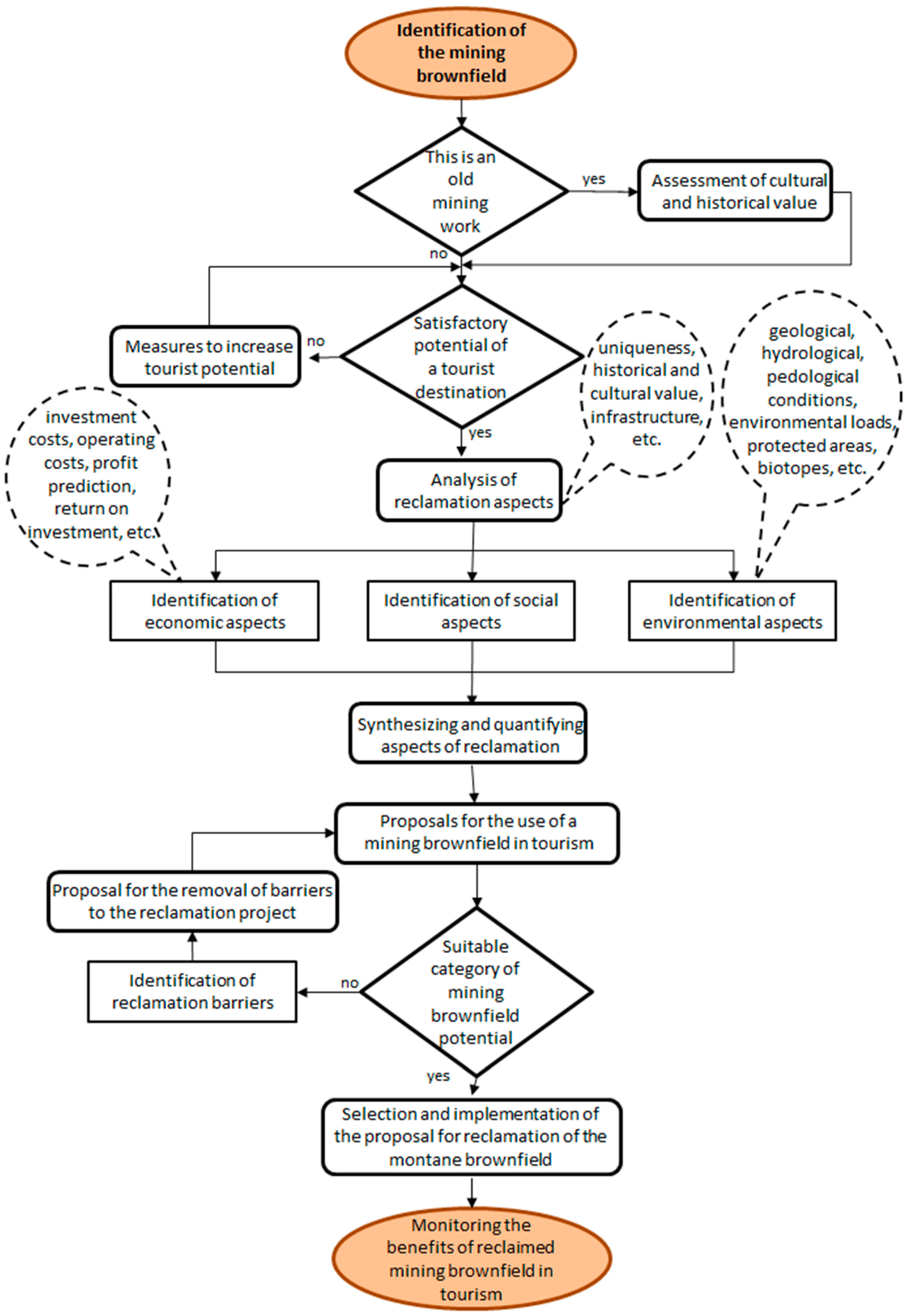
3. Materials and Methods

The recultivation of the mining brownfield—the Fedö shaft and its use to support the sustainable development of regional tourism—is directly determined by the potential of the tourist destination Červenica—Dubník, the quantification of which is based on a scoring scale of exactly defined aspects of the tourist destination [33,34].
After evaluating all clearly defined aspects, their numerical sum was created, and the potential was identified according to Table 1.
A SWOT analysis was carried out for an effective strategy for the reclamation of the mining brownfield to support the sustainable regional development of tourism [35,36,37,38], though it is also widely used in environmental management, implementing quantitative methods trying to remove subjectivity in the evaluation of individual strengths, weaknesses, opportunities, and threats [39].
The following steps outline the SWOT analysis procedure [13,40,41]:
  • Identifying factors—defining the factors relevant to each element—strength, weakness, opportunity, threat—i ϵ S,W,O,T;
  • Building a pairwise comparison matrix to rank the relative importance of factors within each set concerning the objective, and calculating the relative importance weight vectors for each factor (WS, WW, WO, WT);
  • Building a pairwise comparison matrix to evaluate the relative importance of SWOT sets and obtain the relative importance weight vector WG;
  • Evaluating vector E by evaluating each S, W, O, T factor with linguistic variable ei = (ei1, ei2, ei3, ei4);
  • Evaluating each indicator in this way led to the creation of partial row products following Equation (1):
Si = ΠSij; j = 1, 2, 3, …, f,
f—number of factors,
Sij—single factor,
  • Evaluating the indicator interactions by Equation (2):
Ri = Si1/f,
Based on the previous steps of this analytical method, first, the level of weights was quantified by explicitly defined criteria of the analyzed SWOT areas—strengths and weaknesses, and opportunities and threats. We accepted a generally valid condition of ∑αi = 1. Second, the weights were quantified based on Saaty’s matrix, whose dimensions m × n, where m = 1...i and n = 1...j, were given by the number of rows and columns, while the condition m = n was observed (square matrix), which also corresponded to the fact that the method is based on an interactive comparison of all defined criteria of the same order with the evaluation listed in Table 2. Values of 1 were plotted on the diagonal of the matrix to accept the equivalence of the same criteria; in the case of the same criterion given in the row being preferred over the criterion given in the column, a reciprocal value was assigned [39].
The interactions of indicators were calculated based on the comparison of the indicators that quantify the total value of weights αi. Points for criteria were allocated from the key rate <1, 5> (Table 3).
The use of mining brownfields to support the sustainable development of regional tourism is directly determined by the potential of the tourist destinations in which they are located. Based on field research and a data summarization of the specific characteristics of the tourist destination Červenica—Dubník, it was possible to clearly define the aspects determining its tourist potential according to the methodology (Table 4). From an evaluation of the characteristics and aspects of the analyzed tourist destination, it clearly has high potential to support the sustainable regional development of tourism. The high potential of a tourist destination is primarily determined by its geographical location, natural wealth, historical and cultural wealth, and the uniqueness and diversity of the attractions offered to tourists [25,33,43,44]. In terms of infrastructure, this area is average in its range of services, as there are only a few shops and guesthouses in the area. Despite these determinants, this destination belongs to an area with high potential.
The analyzed tourist destination represents a prospective area of investment, as there is a wide range of possibilities and the popularity of opal mines is constantly growing, and the reclamation of old mining objects would increase interest and support sustainable tourism in the region. Another added value is the possibility of creating new job opportunities for the surrounding villages, as, though they are not far from the central cities of Prešov and Košice, there are not many job opportunities, and the reclamation of this shaft as a national cultural monument would possibly contribute to the increase of job opportunities in the primary, secondary, and tertiary spheres of tourism. With the increased interest in this tourist destination, it would be possible to contribute to the interest of visitors in other tourist destinations in the vicinity of Červenica—Dubník, such as the Sigord tourist area or the Zlatá Baňa area. The reclamation of the Fedö shaft, which is determined by a spectrum of environmental, social, and economic aspects, would contribute to the support of sustainable regional tourism development.

3.1. Identification of the Environmental Aspects of Reclamation

The basic platform of the environmental aspects of recultivation of the analyzed mining brownfield is formed by the geographical aspects of the territory, abiotic and biotic components of the environment, geological and hydrogeological aspects of the territory, and the environmental burdens of the territory.

3.1.1. Geographical Aspects of the Territory

Near the mining brownfield, there is a third-class road from which the village of Červenica can be reached, 3–5 km away in the direction of Košice, or in the opposite direction. This road leads to the village of Zlatá Baňa, 5–7 km away in the direction of Prešov. In its vicinity, there are several other mining brownfields, primarily shafts and a reclaimed mine facility, the Jozef tunnel, but other urbanized areas are absent.

3.1.2. Geological and Hydrogeological Aspects

Deposits of precious opals are found in Neogene andesites and their pyroclastics located in the Slanské vrchy mountains. These aspects affect the hydrogeology of the area. It is the subsoil that results in groundwater circulating in a crack-porous environment. It consists of zones formed by rock massif formed by porous volcanic soils and tectonically crushed zones. Due to the distribution of opal mineralization, it is specified by lithological–tectonic factors, which also affect the groundwater cycle, and the mining of these objects is also related to this [26,27]. The occurrence of a precious stone, namely the precious opal, which has an important position in jewelry not only in Slovakia but also abroad, is concentrated in the Červenica—Dubník area in the central part of the Slanské vrchy mountains in the Lower Sarmatian complex of amphibolic–pyroxenic andesites [45,46]. Opal is mainly composed of feldspar (~70%), augite, quartz, and kaolinite; the concentrations of elements Ca, Al, K, Na, Ba, and Sr are mainly found in the host rock, and in opals they are found in lower concentrations [47]. The most common type of gemstone opal is white opal, e.g., gray or white hydrophane. Precious, milky, and glassy opals fill the voids and pores of the parent rock and create tiny impregnations in the cracks of the parent rock. Milk opal is the most common, and is characterized by a milky white color, with shades such as white porcelanite, green chrysopal, and brown wood opal [45]. Gem opal mineralization appeared irregularly, which resulted in the creation of objects that were created by felling and do not resemble a mining object, but rather a cave.

3.1.3. Environmental Loads

In the examined area of Červenica—Dubník, there is no known probable or confirmed burden, and even the mining brownfield itself—the Fedö shaft—is not affected by any contamination, which is a positive aspect of its reclamation.

3.2. Identification of the Social Aspects of Reclamation

The social aspects of the reclamation of the analyzed mining brownfield are formed by the historical, social, and technical characteristics of the Fedö shaft.

3.2.1. Historical and Social Characteristics

The mine and the associated buildings were located at the foot of the Libanka hill, 3 to 4 km from the village of Červenica. The oldest preserved documents, in which the mining of precious opal is written exactly and explicitly about in this location, are the decrees from 1597 when the monarch Rudolf II, a Habsburg, commissioned Albert Magno to look for precious opals in this territory, and from 1603 allowed mining there. Among the most intensive and productive times of opal mining in this area was the period when the opal mines were leased by the Goldschmidt family, an Austrian jeweler’s family who leased the mines from 1845 to 1880, and two generations of this family took turns to run it [48]. The Fedö shaft was the only one belonging to the Libanka opal mine and was used to transport tailings and water from the Wiliem and Jozef tunnels. It was one of the important mining technical facilities, the historical value of which points to the simplification of human work and the reclamation of this mining facility could contribute to the educational activity and insight into the history of technical works of that period, and also in a certain way point out the hard and strenuous work of miners even before the arrival of steam engines. The Fedö shaft was declared a national cultural monument in 1984, therefore, it has socio-cultural and historical value, which is necessary to preserve for future generations [26,27].

3.2.2. Technical Characteristics

The Fedö shaft was excavated from the Viliam tunnel to a depth of approximately 50 m. Three deep horizons were connected to this shaft, and there were also several inter-horizon corridors and chimneys, and falling works, which were supposed to ensure communication between them. Between 1890 and 1896, the depth of the shaft was 76 m. At the turn of the 19th and 20th centuries, the shaft was broken through to the surface and subsequently equipped on the surface. The shaft was used for the vertical transport of material from the Viliam tunnel. A shaft building was added, consisting of a machine room, a boiler room, a steam engine, two boilers, equipment for shaft transport, a steam injector, towing ropes, baskets, a pump, and pipes for a steam pipeline. This technical facility was used from 1900 until the end of mining, and connected with removing gangue and water. The foundations of the entire building were built from natural stone. Two-thirds of the above-ground part were a half-timbered structure, and it is assumed that it was filled with bricks and plastered with lime plaster. The closed towing tower was a wooden construction [26,27]. Currently, the foundations of the shaft and the shaft building remain, while the shaft is partially filled in and flooded with water. Access to the shaft is secured by wooden formwork to prevent accidents.

3.3. Identification of the Economic Aspects of Reclamation

Funding the reclamation of the Fedö shaft is possible from our own or external sources, or their combination, which is most often used in practice. Financing the reclamation of the Fedö shaft from external sources would be possible through [49]:
  • Banking institutions—the European Development Bank, the European Bank for Reconstruction and Development, and individual banks of the Slovak Republic;
  • State funds;
  • Support programs, like the Norwegian Fund;
  • EU funds;
  • Public–private partnerships.

4. Results

A SWOT analysis is, in general, a starting point for the correct formulation of an effective strategy, which will arise from the combination of internal and external factors [39,50]. The basic platform of the SWOT analysis of the reuse of the Fedö shaft for supporting the sustainable development of regional tourism is the clear identification of key factors of strengths and weaknesses, as well as key factors of opportunities and threats [39,42,50].
Based on the information provided so far, and the partial results of the analyses, following the principles of Saaty’s matrix, the weights were quantified by a clearly defined factor of the strengths of the Fedö shaft reclamation project (Table 5) which include:
  • Uniqueness and singleness of the project, not only in Slovakia but also abroad—f1;
  • Very advantageous geographical location within eastern Slovakia—f2;
  • Historical and social value of the project—f3;
  • High tourist potential thanks to the natural landscape and cultural–historic dispositions—f4;
  • Good accessibility and infrastructure—f5;
  • Non-existence of competition in the given area—f6.
In the same way, the weight factor of the weaknesses of the Fedö shaft reclamation project was identified and quantified (Table 6), which included:
  • High input and operating costs—f1;
  • Technical problems with project implementation—f2;
  • Risk of project failure and underutilized project potential—f3;
  • Absence of marketing of tourist destinations—f4;
  • Absence of interest and support from municipalities—f5.
Analogously, the weights and factors of opportunities of the Fedö mine reclamation project (Table 7) were identified and quantified, among which, based on the facts found, were included:
  • Tourists’ interest in new tourism products—f1;
  • Use of surrounding tourist attractions and interaction between the attractions—f2;
  • Use of various financial support programs by municipalities—f3;
  • Increasing popularization of geotourism and “mining” tourism—f4;
  • Use of the advantageous geographical location between the cities of Prešov and Košice—f5.
In the same way, the threats of the Fedö mine reclamation project (Table 8) were identified and quantified, which included:
  • Problematic legislation and bureaucracy in the field of operating old mining works in tourism—f1;
  • Non-existence of social facilities in the immediate vicinity—f2;
  • Unfavorable conditions in tourism and the impact of the pandemic on tourism—f3;
  • Change in preference of tourist destinations and emergence of new trends in tourism—f4.
In terms of the methodological procedure for the implementation of the SWOT analysis, point evaluations were assigned to the factors of the partial areas of the SWOT analysis identified above. The value of their vectors was quantified, given by the sum of the products of the weights αi and the assigned point evaluations, as shown in Table 9.
From the graphical representation of the SWOT analysis of the Fedö shaft reclamation (Figure 1), the use of this mining brownfield should be guided by the principles of the offensive strategy. It fully focuses on the use of strengths and opportunities with the minimization of weaknesses and threats, which also confirms the predicted potential of using reclaimed mining brownfields in supporting the sustainable development of regional tourism.

5. Discussion

The mining brownfields that affect the natural aesthetic character of the landscape are objects related to mining activity that meet the basic characteristics of brownfields, namely [50,51,52,53,54,55,56]
  • They are abandoned;
  • They may be contaminated with pollutants;
  • They were used in the past;
  • They currently require intervention for their reuse from outside.

5.1. Environmental, Social, and Economic Aspects of Reclamation

Considering the facts obtained, the basal platform of mining brownfields consists of quarries, heaps, dumps, tailings ponds, deep mines, tunnels, shafts, pits, waterworks, buildings connected with mining activities, administrative buildings, plants for processing mineral raw materials, warehouses, mining machines, equipment, and technology for mining and processing mineral raw materials [2,14,17,19,20,21,23,24,57,58,59,60,61,62]. From the results of analyses focused on the Fedö shaft, including the proposed methodological procedure for evaluating the potential of the tourist destination and the SWOT analysis of the reclamation, even including regional features [63], it emerged that mining brownfields represents an effective tool for supporting the sustainable development of regional tourism, also confirmed by other studies [64,65,66]. This requires a model of effective management of the use of such unused mining facilities in the area of tourism with a clearly defined methodology for identification and subsequent independent management of mining brownfields, which often represent old mining works, based on territory analysis and expert opinion defining a continuous process of partial implementation steps in the tourism industry [67,68,69].
The initial partial step should be based on the definition of criteria determining the identification of mining brownfields, which include [2,14,17,19,20,21,23,24,57,58,59,60,61,62,63,64,65,66,67,68,69]:
  • The object/location must have been used for mining purposes in the past;
  • It was created by anthropogenic activity;
  • It currently does not perform any function and is abandoned;
  • Its reuse on the market is not possible without external intervention;
  • It must have potential for touristic use.
In the next step, analyses of two basic areas are necessary, namely:
  • An analysis of the tourist destination where the mining brownfield is located, according to the methodological procedure;
  • An analysis of aspects of mining brownfield reclamation, the basic platform of which is the identification of environmental, social, and economic characteristics, with the acceptance of the principles of sustainable development.
Based on the evaluation of the above aspects, it is possible to identify positive and negative indicators of reclamation, which are compared. Their weights αi are numerically quantified by the Saaty matrix, finding out whether positive indicators prevail over negative ones, and identifying the potential for supporting sustainable regional tourism development.
The positive determinants or indicators of reclamation of the Fedö shaft include:
  • Uniqueness of the project—I1;
  • Geological conditions—I2;
  • Historical and cultural characteristics– I3;
  • Transport infrastructure—I4;
  • Offer of tourist attractions—I5;
  • Natural wealth—I6;
  • Geographical location of the mining brownfield—I7.
The negative determinants or indicators of the Fedö mine reclamation include:
  • Technical aspects of the project—I1;
  • Changing preferences of tourists in the tourist destination—I2;
  • Risk of increasing costs during reclamation—I3;
  • Lack of social facilities in the vicinity—I4;
  • Complex legislation in making available old mine works—I5;
  • High entry costs—I6;
  • The risk of an unfavorable situation in tourism, e.g., the impact of the pandemic—I7.
In terms of the principles of the Saaty matrix, the level of weights αi, which determine the prioritization of positive indicators (Table 10) and negative indicators (Table 11), were quantified (Table 12). An emphasis was put on profiling the potential of a specific category of regional tourism development support based on the value of the scoring ratio, which reached a level of 1.19 (Table 13). The value of the scoring ratio pointed to the high potential of using the Fedö shaft to support the sustainable regional development of tourism.

5.2. Model of Effective Mining Brownfield Management

Based on the above-described categories of the potential of supporting the sustainable regional development of tourism, a project must be made to reuse the mining brownfield in tourism. If the category ranges from IV–VI, it is necessary to identify the barriers to the project, and, subsequently, it is necessary to propose the removal of these barriers. If the category is in the range I.–III., it is necessary to choose the most suitable project for the reclamation of the mining brownfield in tourism, while it is necessary to accept the landscape–ecological significance and evaluation of the mining brownfield from the view of its past use, current state, and future use. The next step is the implementation of the reclamation project and subsequent monitoring of the benefits of the reclaimed mining brownfield in tourism development (Figure 2). All the indicators of mining brownfield reclamation, explicitly listed in Table 12, were encompassed in the suggested model of effective mining brownfield management for the sustainable development of regional tourism.

6. Conclusions

The history of Slovakia relates to the mining and processing of raw mineral materials. As a result of the turbulent political–economic changes in 1989, which determined the transition from the primary and secondary economy to the tertiary economy—service economy—there was a continuous decline in the mining industry. These aspects led to the creation of mining brownfields which in many regions of the Slovak Republic represent an effective tool for supporting the sustainable regional development of tourism, primarily due to their social and cultural value. These include various cultural or technical monuments that point to the method of extracting mineral resources, but also to a certain social stage of development and the culture of the given region. These represent the key determinants of their use as an effective means of supporting the development of tourism, especially geotourism.
The mentioned facts point to the necessity of solving the problem of mining brownfields, not only in sustainable regional tourism development but also in other national economic sectors. However, the nature and fact that the reuse of mining brownfields, which often include old mining works threatening public interests, contributes to the improvement of environmental quality and socio-economic aspects profiling the functional model of sustainable development of anthropogenic society. This points to the necessity of solving this problem with the integration of the proposed model of effective management of mining brownfields to support the regional development of tourism, which is conceived as open and therefore fully applicable in other national economic sectors.
This analysis has some limitations. The SWOT analysis, based on 20 factors—six strengths, five weaknesses, five opportunities, and four threats—provided a useful overview. Seven positive and seven negative factors of reclamation were identified to inform a sustainable strategy for the reclamation and the potential of supporting the sustainable regional development of tourism. While these findings are specific to the local situation, they have broader implications for sustainable tourism development and could be applied elsewhere. Future research could explore alternative evaluation methods, incorporate additional SWOT positive/negative factors, and consider other relevant resources. The financial and economic feasibility of the suggested measures can be studied in detail. This would enhance the understanding of sustainable mining brownfield management and its potential for promoting regional tourism globally.

Author Contributions

Conceptualization, H.P. and T.B.; methodology, H.P.; validation, H.P., T.B. and M.M.; formal analysis, H.P. and T.B.; investigation, H.P. and T.B.; resources, H.P., T.B. and M.M.; data curation, H.P. and T.B.; writing—original draft preparation, H.P. and T.B.; writing—review and editing, T.B.; visualization, H.P. and T.B. All authors have read and agreed to the published version of the manuscript.

Funding

This research received no external funding.

Institutional Review Board Statement

Not applicable.

Informed Consent Statement

Not applicable.

Data Availability Statement

Data are contained within the article.

Conflicts of Interest

The authors declare no conflicts of interest.

References

  1. Očenášová, M.; Pavolová, H.; Bakalár, T.; Šimková, Z. The use of brownfields in the sustainable development of tourism in SR. In Geotour 2018: Book of Abstracts; Technická univerzita v Košiciach: Košice, Slovakia, 2018; p. 17. [Google Scholar]
  2. Gregorová, B.; Hronček, P.; Tometzová, D.; Molokáč, M.; Čech, V. Transforming Brownfields as Tourism Destinations and Their Sustainability on the Example of Slovakia. Sustainability 2020, 12, 10569. [Google Scholar] [CrossRef]
  3. Pytel, S.; Sitek, S.; Chmielewska, M.; Zuzańska-Żyśko, E.; Runge, A.; Markiewicz-Patkowska, J. Transformation Directions of Brownfields: The Case of the Górnośląsko-Zagłębiowska Metropolis. Sustainability 2021, 13, 2075. [Google Scholar] [CrossRef]
  4. Pavolová, H.; Kyseľová, K.; Bakalár, T. Brownfields as a tool for support of Destination Tourism development. Acta Geoturistica 2012, 3, 26–30. [Google Scholar]
  5. Ren, W.; Xue, B.; Yang, J.; Lu, C. Effects of the Northeast China Revitalization Strategy on Regional Economic Growth and Social Development. Chin. Geogr. Sci. 2020, 30, 791–809. [Google Scholar] [CrossRef]
  6. Ivona, A.; Rinella, A.; Rinella, F.; Epifani, F.; Nocco, S. Resilient Rural Areas and Tourism Development Paths: A Comparison of Case Studies. Sustainability 2021, 13, 3022. [Google Scholar] [CrossRef]
  7. Pavolová, H.; Kyseľová, K. Resolving the issue of brownfields in conditions of the EU. In Proceedings of the SGEM 2011: 11th International Multidisciplinary Scientific GeoConference, Albena, Bulgaria, 20–25 June 2011; STEF92 Technology: Sofia, Bulgaria, 2011; Volume 2, pp. 1297–1303. [Google Scholar]
  8. Vanheusden, B. Towards a Legal Framework in the EU for Brownfield Redevelopment. Eur. Energy Environ. Law Rev. 2003, 12, 178–186. [Google Scholar] [CrossRef]
  9. Ministerstvo Výstavby a Regionálneho Rozvoja Slovenskej Republiky: Národná Stratégia Regionálneho Rozvoja Slovenskej Republiky. Available online: https://mirri.gov.sk/wp-content/uploads/mpsr-files/8924-4.pdf (accessed on 15 July 2022).
  10. Dragan, W.; Zdyrko, A. The spatial dimension of coal phase-out: Exploring economic transformation and city pathways in Poland. Energy Res. Soc. Sci. 2023, 99, 103058. [Google Scholar] [CrossRef]
  11. Petrovič, F.; Boltižiar, M.; Rakytová, I.; Tomčíková, I.; Pauditšová, E. Long-Term Development Trend of the Historical Cultural Landscape of the UNESCO Monument: Vlkolínec (Slovakia). Sustainability 2021, 13, 2227. [Google Scholar] [CrossRef]
  12. Ghabouli, E.; Soltani, A.; Ehsan Ranjbar, E. Heritage and the Regeneration of Urban Brownfields: Insights on Public Perception in Tehran, Iran. Heritage 2023, 6, 4451–4471. [Google Scholar] [CrossRef]
  13. Pavolová, H.; Bakalár, T.; Emhemed, E.M.A.; Hajduová, Z.; Pafčo, M. Model of sustainable regional development with implementation of brownfield areas. Entrep. Sustain. Issues 2019, 6, 1088–1100. [Google Scholar] [CrossRef]
  14. Kantor-Pietraga, I.; Zdyrko, A.; Bednarczyk, J. Semi-Natural Areas on Post-Mining Brownfields as an Opportunity to Strengthen the Attractiveness of a Small Town. An Example of Radzionków in Southern Poland. Land 2021, 10, 761. [Google Scholar] [CrossRef]
  15. Šimková, Z.; Seňová, A.; Divoková, A.; Očenášová, M.; Varga, P. Possibilities of Using Brownfields After Mining and Processing of Mineral Resources in Slovakia. E3S Web Conf. 2019, 105, 02023. [Google Scholar] [CrossRef]
  16. Ashworth, G.J. Preservation, Conservation and Heritage: Approaches to the Past in the Present through the Built Environment. Asian Anthropol. 2012, 10, 1–18. [Google Scholar] [CrossRef]
  17. Bostenaru Dan, M.; Bostenaru-Dan, M.M. Greening the Brownfields of Thermal Power Plants in Rural Areas, an Example from Romania, Set in the Context of Developments in the Industrialized Country of Germany. Sustainability 2021, 13, 3800. [Google Scholar] [CrossRef]
  18. Vráblík, P.; Wildová, E.; Šulgan, M. Urban brownfields in an anthropogenically affected area of Northern Bohemia. In Proceedings of the International Multidisciplinary Scientific GeoConference: SGEM, Albena, Bulgari, 18–24 August 2020; Volume 20. [Google Scholar] [CrossRef]
  19. Botezan, C.; Constantin, V.; Meltzer, M.; Radovici, A.; Pop, A.; Alexandrescu, F.; Stefanescu, L. Is There Sustainable Development after Mining? A Case Study of Three Mining Areas in the Apuseni Region (Romania). Sustainability 2020, 12, 9791. [Google Scholar] [CrossRef]
  20. Newton, R.A.; Pidlisnyuk, V.; Wildová, E.; Nováková, L.; Trögl, J. State of Brownfields in the Northern Bohemia, Saxony and Lower Silesian Regions and Prospects for Regeneration by Utilization of the Phytotechnology with the Second Generation Crops. Land 2023, 12, 354. [Google Scholar] [CrossRef]
  21. Kantor-Pietraga, I.; Krzysztofik, R.; Solarski, M. Planning Recreation around Water Bodies in Two Hard Coal Post-Mining Areas in Southern Poland. Sustainability 2023, 15, 10607. [Google Scholar] [CrossRef]
  22. Streit, S.; Tost, M.; Gugerell, K. Perspectives on Closure and Revitalisation of Extraction Sites and Sustainability: A Q-Methodology Study. Resources 2023, 12, 23. [Google Scholar] [CrossRef]
  23. Pactwa, K.; Woźniak, J.; Dudek, M. Sustainable Social and Environmental Evaluation of Post-Industrial Facilities in a Closed Loop Perspective in Coal-Mining Areas in Poland. Sustainability 2021, 13, 167. [Google Scholar] [CrossRef]
  24. Mojses, M.; Petrovič, F.; Bugár, G. Evaluation of Land-Use Changes as a Result of Underground Coal Mining—A Case Study on the Upper Nitra Basin, West Slovakia. Water 2022, 14, 989. [Google Scholar] [CrossRef]
  25. Čech, V.; Gregorová, B.; Krokusová, J.; Košová, V.; Hronček, P.; Molokáč, M.; Hlaváčová, J. Environmentally Degraded Mining Areas of Eastern Slovakia As a Potential Object of Geotourism. Sustainability 2020, 12, 6029. [Google Scholar] [CrossRef]
  26. Semrád, P. Bansko-technické aspekty dobývania drahoopálovej mineralizácie v lokalite Červenica—Dubník v rokoch 1785 až 1922. In Montánno-Historický Výskum na Slovensku a v Strednej Európe. Montánna História 10; Slovenská Spoločnosť pre Sociálne a Hospodárske Dejiny: Bratislava, Slovakia, 2019; pp. 178–221. [Google Scholar]
  27. Semrád, P. Genéza nehnuteľného majetku banského závodu na ťažbu drahého opálu v lokalite Červenica—Dubník v priebehu 19. storočia. In Montánno-Historický Výskum na Slovensku a v Strednej Európe. Montánna História 10; Slovenská Spoločnosť Pre sociálne a Hospodárske Dejiny: Bratislava, Slovakia, 2019; pp. 222–273. [Google Scholar]
  28. Slanské vrchy—Časť Šimonka. Available online: https://www.slanskevrchy.eu/slanske-vrchy-cast-simonka/ (accessed on 17 December 2023).
  29. Lesný Cykloturistický Náučný Chodník Sigord. Available online: https://naucnechodniky.eu/lesny-cykloturisticky-naucny-chodnik-sigord/ (accessed on 17 December 2023).
  30. Hrad Bodoň. Available online: https://www.severovychod.sk/vylet/hrad-bodon/ (accessed on 17 December 2023).
  31. Sigord—Vodná Nádrž. Available online: https://www.regionsaris.sk/sport/sigord-vodna-nadrz/ (accessed on 17 December 2023).
  32. Program Hospodárskeho a Sociálneho Rozvoja Obce Zlatá Baňa 2016–2022. Available online: https://zlatabana.sk/wp-content/uploads/2020/02/PHaSR.pdf (accessed on 17 December 2023).
  33. Hlavňová, B.; Pavolová, H. The present condition of tourist comfort in mining tourism in Slovakia. In Knowledge for Market Use 2017: People in Economics—Decisions, Behavior and Normative Models; Palacký University: Olomouc, Czech Republic, 2017; pp. 421–428. [Google Scholar]
  34. Król, K.; Zdonek, D.; Sroka, W. Functionality Assessment Checklist for Evaluating Geoportals Useful in Planning Sustainable Tourism. Sustainability 2024, 16, 5242. [Google Scholar] [CrossRef]
  35. Kulczycka, J.; Pietrzyk-Sokulska, E. Master Plan as A Tool for Post-Mining Water Reservoirs Management—A Cases in Poland. Am. J. Environ. Prot. 2013, 1, 59–65. [Google Scholar] [CrossRef]
  36. Borojević Šoštarić, S.; Giannakopoulou, S.; Adam, K.; Mileusnić, M. The future of mining in the Adria region: Current status, SWOT and Gap analysis of the mineral sector. Geol. Croat. 2022, 75, 317–334. [Google Scholar] [CrossRef]
  37. Białas, A.; Kozłowski, A. Computer-Aided Planning for Land Development of Post-Mining Degraded Areas. Sustainability 2024, 16, 1528. [Google Scholar] [CrossRef]
  38. Sang, K.; Lin, G. A Landscape Design Strategy for the Regeneration of Brownfield: The Case of Shougang Industrial Park in China. In Resilient and Responsible Smart Cities; Krüger, E.L., Karunathilake, H.P., Alam, T., Eds.; Advances in Science, Technology & Innovation; Springer: Cham, Switzerland, 2023. [Google Scholar] [CrossRef]
  39. White, T.H., Jr.; Barros, Y.d.M.; Develey, P.F.; Llerandi-Román, I.C.; Monsegur-Rivera, O.A.; Trujillo-Pinto, A.M. Improving reintroduction planning and implementation through quantitative SWOT analysis. J. Nat. Conserv. 2015, 28, 149–159. [Google Scholar] [CrossRef]
  40. Bakalár, T.; Pavolová, H.; Hajduová, Z.; Lacko, R.; Kyšeľa, K. Metal recovery from municipal solid waste incineration fly ash as a tool of circular economy. J. Clean. Prod. 2021, 302, 126977. [Google Scholar] [CrossRef]
  41. Bakalár, T.; Pavolová, H.; Tokarčík, A. Analysis and model of river basin sustainable management by SWOT and AHP methods. Water 2021, 13, 2427. [Google Scholar] [CrossRef]
  42. Saaty, R.W. The analytic hierarchy process—What it is and how it is used. Math. Modell. 1987, 9, 161–176. [Google Scholar] [CrossRef]
  43. Ezenagu, N. Heritage resources as a driver for cultural tourism in Nigeria. Cogent Arts Humanit. 2020, 7, 1734331. [Google Scholar] [CrossRef]
  44. De la Cruz del Río-Rama, M.; Maldonado-Erazo, C.P.; Álvarez-García, J.; Durán-Sánchez, A. Cultural and Natural Resources in Tourism Island: Bibliometric Mapping. Sustainability 2020, 12, 724. [Google Scholar] [CrossRef]
  45. Harman, M.; Chovanec, V. Mikrotextúry dubníckych opálov a ich vzťah k opalizácii. Miner. Slovaca 1981, 13, 193–209. [Google Scholar]
  46. Herčko, I. Drahé Kamene zo Slovenska. Geol. Průzkum 1987, 29, 330–331. [Google Scholar]
  47. Caucia, F.; Marinoni, L.; Leone, A.; Adamo, I. Investigation on the gemological, physical and compositional properties of some opals from Slovakia (“Hungarian” opals). Period. Di Mineral. 2013, 82, 251–261. [Google Scholar] [CrossRef]
  48. Semrád, P. The Story of European Precious Opal from Dubník; Granit: Praha, Czech Republic, 2011. [Google Scholar]
  49. Cehlár, M.; Antošová, M.; Seňová, A. Financing options for revitalizing of brownfields in Slovakia. In Proceedings of the SGEM 2013: 13th International Multidisciplinary Scientific Geoconference: Ecology, Economics, Education and Legislation, Albena, Bulgaria, 16–22 June 2013; STEF92 Technology Ltd.: Sofia, Bulgaria, 2013; Volume 2, pp. 161–168. [Google Scholar]
  50. Gürel, E.; Tat, M. SWOT analysis: A theoretical review. J. Int. Soc. Res. 2017, 10, 994–1006. [Google Scholar] [CrossRef]
  51. Han, S.H.; Li, A.Z. A Hundred Stories: Industrial Heritage Changes China; Palgrave Macmillan Singapore: Singapore, 2023. [Google Scholar] [CrossRef]
  52. Walmsley, L. Sustainable Development And Green Landscaping. In Green Facilities Handbook: Simple and Profitable Strategies for Managers, 1st ed.; Woodroof, E., Ed.; River Publishers: New York, NY, USA, 2020. [Google Scholar] [CrossRef]
  53. Modica, M. Alpine Industrial Landscapes: Towards a New Approach for Brownfield Redevelopment in Mountain Regions; Springer: Freising, Germany, 2021. [Google Scholar] [CrossRef]
  54. Cherevatskyi, D.; Mykhenko, V.; Soldak, M. Three-dimensional brownfields: The tragedy of the mining communities. J. Eur. Econ. 2023, 22, 556–570. [Google Scholar] [CrossRef]
  55. Hajduková, R.; Sopirová, A. Typology of terrain vague and emergence mechanisms in post-communist, post-industrial small and medium-sized towns in Slovakia: Case study of Humenné, Strážske and Vranov and Topľou. Archit. Pap. Fac. Archit. Des. STU 2023, 2, 21–29. [Google Scholar] [CrossRef]
  56. Gras, J.M. Conservation of the Peri-urban Landscape. In Peri-Urban Landscape, 1st ed.; Gras, J.M., Pace, L., Eds.; River Publishers: New York, NY, USA, 2024. [Google Scholar] [CrossRef]
  57. Vicari Aversa, C.S. A Valuable Brownfield Site by the Sea Awaiting Regeneration: The Case of the Lipari Pumice Quarries. In Computational Science and Its Applications—ICCSA 2024 Workshops. ICCSA 2024; Gervasi, O., Murgante, B., Garau, C., Taniar, D.C., Rocha, A.M.A., Faginas Lago, M.N., Eds.; Lecture Notes in Computer Science; Springer: Cham, Switzerland, 2024; Volume 14820. [Google Scholar] [CrossRef]
  58. Krzysztofik, R.; Dulias, R.; Kantor-Pietraga, I.; Spórna, T.; Dragan, W. Paths of urban planning in a post-mining area. A case study of a former sandpit in southern Poland. Land Use Policy 2020, 99, 104801. [Google Scholar] [CrossRef]
  59. Gligor, V.; Nicula, E.-A.; Crețan, R. The Identification, Spatial Distribution, and Reconstruction Mode of Abandoned Mining Areas. Land 2024, 13, 1107. [Google Scholar] [CrossRef]
  60. Madlener, R.; Specht, J.M. An Exploratory Economic Analysis of Underground Pumped-Storage Hydro Power Plants in Abandoned Deep Coal Mines. Energies 2020, 13, 5634. [Google Scholar] [CrossRef]
  61. Aristizabal-H, G.; Goerke-Mallet, P.; Kretschmann, J.; Restrepo-Baena, O.J. Sustainability of coal mining. Is Germany a post-mining model for Colombia? Resour. Policy 2023, 81, 103358. [Google Scholar] [CrossRef]
  62. Rahmonov, O.; Krzysztofik, R.; Srodek, D.; Smolarek-Lach, J. Vegetation- and Environmental Changes on Non-Reclaimed Spoil Heaps in Southern Poland. Biology 2020, 9, 164. [Google Scholar] [CrossRef]
  63. Mazurets, R.R.; Havrylenko, T.V.; Serbenivska, A.Y.; Zhuchenko, V.G. Event potential of the tourist destination «DUBNO» as a tool for innovative development of the region. J. Geol. Geogr. GeoEcol. 2021, 31, 110–119. [Google Scholar] [CrossRef]
  64. Skiba, M.; Mrówczyńska, M.; Sztubecka, M.; Maciejko, A.; Rzeszowska, N. The European Union’s Energy Policy Efforts Regarding Emission Reduction in Cities—A Method Proposal. Energies 2023, 16, 6123. [Google Scholar] [CrossRef]
  65. Janiszek, M.; Krzysztofik, R. Green Infrastructure as an Effective Tool for Urban Adaptation—Solutions from a Big City in a Postindustrial Region. Sustainability 2023, 15, 8928. [Google Scholar] [CrossRef]
  66. Rebernik, L.; Vojvodíková, B.; Lampič, B. Brownfield Data and Database Management—The Key to Address Land Recycling. Land 2023, 12, 252. [Google Scholar] [CrossRef]
  67. Milošević, M.R.; Milošević, D.M.; Stanojević, A.D.; Stević, D.M.; Simjanović, D.J. Fuzzy and Interval AHP Approaches in Sustainable Management for the Architectural Heritage in Smart Cities. Mathematics 2021, 9, 304. [Google Scholar] [CrossRef]
  68. Ionascu, A.E.; Goswami, S.S.; Dănilă, A.; Horga, M.-G.; Barbu, C.A.; ¸Serban-Comanescu, A. Analyzing Primary Sector Selection for Economic Activity in Romania: An Interval-Valued Fuzzy Multi-Criteria Approach. Mathematics 2024, 12, 1157. [Google Scholar] [CrossRef]
  69. Martínez-López, J.; Albaladejo, J.; de Vente, J. Participatory modelling for sustainable development: Connecting coastal and rural social-ecological systems. Environ. Modell. Softw. 2024, 177, 106061. [Google Scholar] [CrossRef]
Figure 1. Graphical representation of the SWOT analysis of the Fedö shaft reclamation.
Sustainability 16 07986 g001
Figure 2. Model of effective mining brownfield management for the sustainable development of regional tourism.
Sustainability 16 07986 g002
Table 1. The potential of sustainable regional tourism development support.
Destination PotentialScoring Scale
High potential21—30
Average potential11–20
Low potential6–10
Table 2. Evaluation of factors [39,42].
ValueExplanation
1Equivalence of the factors i and j
3Slight preference of factor i over j
5Strong preference of factor i over j
7High preference of factor i over j
9Absolute preference of factor i over j
Table 3. Allocation of points [39,42].
PointsCriteria Are
1significantly below average
2below average
3at an average
4above average
5significantly above average
Table 4. Evaluation of the potential of a tourist destination.
Aspects of the Tourist DestinationEvaluation of Aspects of the Tourist DestinationPoint Assessment of Aspects
ExcellentVery GoodGoodPoorVery Poor
Geographical location543215
Natural resources543215
Historical and cultural wealth543215
Uniqueness and spectrum of attractions543215
Transport infrastructure543213
SUM 26
Table 5. Quantification of strength weights.
Factor/Interactionf1f2f3f4f5f6SjRjαi
f11555732625.003.710.45
f21/5131/3331.801.100.13
f31/51/311/331/30.020.530.06
f41/53315327.001.730.21
f51/71/31/31/511/30.0010.320.04
f61/31/331/3310.330.830.10
Sum 8.231.00
Table 6. Quantification of weakness weights.
Factor/Interactionf1f2f3f4f5SjRjαi
f113377441.003.380.47
f21/3135525.001.900.26
f31/31/31552.781.230.17
f41/71/51/511/30.0020.290.04
f51/71/51/5310.020.440.06
Sum 7.241.00
Table 7. Quantification of opportunity weights.
Factor/Interactionf1f2f3f4f5SjRjαi
f111/331/551.001.000.15
f231735315.003.160.49
f31/31/711/31/50.0030.320.05
f451/3311/31.671.110.17
f51/51/55310.600.900.14
Sum 6.491.00
Table 8. Quantification of threat weights.
Factor/Interactionf1f2f3f4SjRjαi
f1171/3511.671.850.29
f21/711/730.060.500.08
f33715105.003.200.51
f451/31/510.330.760.12
Sum 6.311.00
Table 9. SWOT analysis of Fedö shaft reclamation.
StrengthsαiPointsSumWeaknessesαiPointsSum
Uniqueness and singleness of the project, not only in Slovakia but also abroad0.4552.256High input and operating costs0.4752.334
Very advantageous geographical location within eastern Slovakia0.1340.536Technical problems with project implementation0.2630.789
Historical and social value of the project0.0640.258Risk of project failure and underutilized project potential0.1740.678
High tourist potential thanks to the natural landscape and cultural–historic dispositions0.2140.842Absence of marketing of tourist destinations0.0430.118
Good accessibility and infrastructure0.0430.116Absence of interest and support from municipalities0.0630.184
Non-existence of competition in the given area0.1050.506
Sum1.00 4.51Sum1.00 4.10
OpportunitiesαiPointsSumThreatsαiPointsSum
Tourists’ interest in new tourism products0.1530.46Problematic legislation and bureaucracy in the field of operating old mining works in tourism0.2951.47
Use of surrounding tourist attractions and interaction between the attractions0.4952.44Non-existence of social facilities in the immediate vicinity0.0830.24
Use of various financial support programs by municipalities0.0530.15Unfavorable conditions in tourism and the impact of the pandemic on tourism0.5142.03
Increasing popularization of geotourism and “mining” tourism0.1740.68Change in preference of tourist destinations and emergence of new trends in tourism0.1230.36
Use of the advantageous geographical location between the cities of Prešov and Košice0.1440.56
Sum1.00 4.28Sum1.00 4.09
Table 10. Prioritization of positive indicators of reclamation.
Indicator/InteractionI1I2I3I4I5I6I7SjRjαi
I113533331215.002.760.31
I21/311/3351/31/30.190.790.09
I31/5317353189.002.110.24
I41/31/31/7111/31/30.000.400.05
I51/31/51/3111/31/30.000.420.05
I61/331/533135.401.270.15
I71/331/3331/311.001.000.11
Sum 8.761.00
Table 11. Prioritization of negative indicators of reclamation.
Indicator/InteractionI1I2I3I4I5I6I7SjRjαi
I113533331215.002.760.31
I21/311/3351/31/30.190.790.09
I31/5317353189.002.110.24
I41/31/31/7111/31/30.000.400.05
I51/31/51/3111/31/30.000.420.05
I61/331/533135.401.270.15
I71/331/3331/311.001.000.11
Sum 8.761.00
Table 12. Category of mining brownfield potential to support regional tourism development.
CategoryScoring
I.Very highAbove 1.2
II.High1.01–1.2
III.Average0.71–1.0
IV.Low0.51–0.7
V.Very low0.26–0.5
Table 13. Scoring ratio quantification.
Indicators of Mining Brownfield ReclamationType of IndicatorPartial ScoreTotal ScoreScoring Ratio
Uniqueness of the project+17.11754.356811.191
Geological conditions+4.877
Historical and cultural characteristics+13.121
Transport infrastructure+2.508
Offer of tourist attractions+2.632
Natural wealth+7.896
Geographical location of the mining brownfield+6.205
Technical aspects of the project3.56345.64319
Changing preferences of tourists in the tourist destination3.563
Risk of increasing costs during reclamation2.862
Lack of social facilities in the vicinity4.534
Complex legislation in making available old mine works4.215
High entry costs8.494
The risk of an unfavorable situation in tourism, e.g., the impact of the pandemic18.413
Disclaimer/Publisher’s Note: The statements, opinions and data contained in all publications are solely those of the individual author(s) and contributor(s) and not of MDPI and/or the editor(s). MDPI and/or the editor(s) disclaim responsibility for any injury to people or property resulting from any ideas, methods, instructions or products referred to in the content.

