Article

The Impact of Urban Expressways on the Street Space of Traditional Tibetan Villages in Kham, Taking Daofu County as an Example

College of Civil Engineering and Architecture, Southwest University of Science and Technology, Mianyang 621010, China
*
Authors to whom correspondence should be addressed.
Sustainability 2023, 15(4), 3513; https://doi.org/10.3390/su15043513
Submission received: 15 November 2022 / Revised: 4 February 2023 / Accepted: 6 February 2023 / Published: 14 February 2023
(This article belongs to the Section Sustainable Urban and Rural Development)

Abstract

:
Villages are integral to population gathering in the Tibetan ethnic area of Kham, and their spatial formation is influenced by various factors such as topography, river and canyon direction, etc. This study focuses on the impact of urban expressways on traditional villages there. In this study, we take 18 well-preserved traditional villages in the Kham area as examples, construct an axial model and a visual field model from the perspective of space syntax, simulate the basic data required for the algorithm, and further calculate the categorized spatial measures and star model of the streets. One-way ANOVA and Tukey’s multiple comparisons test are adopted to statistically analyze the above spatial measures. The results show that villages intersecting urban expressways have high categorized spatial measures. In addition, it is found that the sample adjacent to the expressway with the lowest mean NACH value (1.396) has the highest mean NAIN value (1.703). The sample with the highest mean NAIN (0.930) intersecting the urban expressway has the lowest mean NACH (0.743). The above approach presents certain reference values for the urbanization of traditional villages in India and Nepal, where topographic and climatic conditions are similar.

1. Introduction

1.1. Background of the Study and Its Significance

A traditional village is an integral part of the spiritual and material culture of a region, and traditional villages with ethnic characteristics are the carriers of various local cultures within a particular region and historical period [1,2,3,4,5,6]. The “Rural Revitalization Strategy” launched in China in recent years attaches great importance to the preservation and development of traditional villages [7]. However, as China’s villages and towns embrace growing the economy and accelerating urbanization, conservation issues related to these traditional villages with distinctive features continue to arise [8]. Failure of local conservation planning to meet the needs of its socio-economic development, coupled with its shortage of conservation funds and frequent mismanagement, has led to destruction of some valuable local historic street structures to varying degrees, and the villages have gradually become hollowed out [9]. Questions of how to restore the original structure of the village streets and their mapping and how to preserve their historical heritage have become the most pressing issues for researchers [10].

1.2. Research History and Current Status

Traditional village space, in terms of the physical and cultural aspects, consists mainly of overall space, architectural space, and street space [11]. Dwellings in rural settlements were thoroughly studied in Liu Dunzhen’s [12] Introduction to Chinese Dwellings and Zhang Zhongyi’s [13] Dwellings of Ming Dynasty in Huizhou in 1957. Not only have the spatial and physical forms of villages been described in detail, such as the layout of villages, their topographical environment, architectural forms, streets and alleys, indoor and outdoor spaces, ponds and watercourses, but the non-material forms, such as cultural and social norms, have been intensively studied as well. The book Landscape Analysis of Traditional Village Settlements written by Peng Yigang [14] in 1992 is also an outstanding representative of early village studies, which comprehensively and systematically analyzes the significant effects brought about by natural and socio-cultural factors on the outer form and landscape of such settlements. In 2001, Wu Liangyong’s [15] Introduction to Habitat Science systematically studied the impact of habitat science ideas on settlements. In recent years, Chen et al. [16] took Chengkan village in the core area of Huizhou as a research object to verify its rationality from the perspective of cultural ecosystems and explored its spatial evolution process, characteristics, and driving factors. Pei et al. [17] analyzed the spatial layout and inter-village spatial characteristics of the Hongguan village cluster in Wuyuan County, Jiangxi Province, via a combination of literature review and field survey, qualitative and quantitative analysis, and other research methods.
It is easy to see that most studies on the streets of traditional Chinese villages still remain qualitative, but with the rise of the theory of space syntax, we are gradually moving our attention to quantitative studies as well [18]. In 1989, Hillier introduced the concept of space syntax in his book The Social Logic of Space, describing and analyzing in detail how the various spatial patterns generated by buildings and towns have developed on the basis of space syntax [19]. In 1993, Hillier used space syntax theory to link pedestrian and vehicular movement patterns to urban morphology to study the configurational relationships of urban systems [20]. Since then, research on space syntax for cities has begun to take on a new life.
Giannopoulou et al. [21] used Depthmap software to reveal the core as well as the most important and congested parts of the city, verifying the impact of space syntactic properties of urban public space on the achievement of regeneration study objectives. Lebendiger and Lerman [22] proposed applying a space syntactic configuration approach to assist in the planning of surface BRT routes in urban areas, while providing new and rapid ideas for the rehabilitation of village street structures as well. Eldiasty et al. [23] combined the TOPSIS method with space syntactic analysis to identify the best locations for relocation of the Rosetta market in Egypt as part of the city’s architectural heritage, which is an approach that focused only on the comparison of nodes within individual villages. Liao et al. [24] proposed a method for quantitatively analyzing the spatial patterns of historic towns using a space syntactic approach, and in their study, they pointed out that past research on historic towns was biased and qualitative and that existing studies have gradually become quantitative, but are mostly limited to specific individual historic towns with unclear boundaries. This study fills in a gap in this field, but its main focus is also on historical capitals of a planned nature, which differ somewhat from spontaneous growth of village structures. Xu et al. [25] used the spatial sentence method to establish an axial model and a spatial syntax model to explore renewal of one single traditional village of Longtan in Guizhou Province, and a series of studies of the village structures were absent. Sun et al. [26] conducted a qualitative street classification and a quantitative space syntactic median analysis of the streets in the traditional village of Nanyuan in the Zhuozhang River basin and had a preliminary sense of traditional village system research, but failed to conduct research on the related street node spaces. Xu et al. [25] took Cuiwei Village in Qianshan District, Zhuhai, as an example, and conducted a survey and analysis of the village through field research to study its street scale, spatial structure, functional characteristic streets, and internal commercial distribution forms and functions.
At the same time, the special location of the Tibetan Plateau area only gained researchers’ attention in the last decade thanks to increasing urban development, and there is still room for development in the study of spatial structure and of syntactic application in traditional Tibetan Plateau villages [27,28,29,30,31]. Zhang et al. [32] studied the spatial characteristics of three Jiarong Tibetan settlements using diagrammatic language and summarized their spatial language patterns. Zhang et al. [33] used mathematical methods to study Tibetan settlements, and their results confirmed the existence of centrality in Tibetan settlements, which provided theoretical support for subsequent qualitative studies. Tang et al. [34] used GIS and space syntax to analyze and evaluate the tourism spaces in Sichuan and Tibet, while Jin et al. [35] conducted a data-based study of the distribution of villages in the Qinghai–Tibetan plateau region and pointed out that the distribution of villages featured “large scattering and small clustering”.

1.3. Research Innovation and Value

It has been found from previous studies on space syntax that most studies focus on the analysis of urban traffic, with less attention paid to the hierarchical classification of spaces. A few studies on rural villages have mostly focused on spatial nodes or more macroscopic descriptive studies of areas, and the spatial situation of villages as a whole has been skimmed over. Few space syntactic analyses of villages have been able to create a regular cognition. In general, there is still a gap in quantitative analysis related to villages, and village analysis with a large number of mathematical measures is still lacking.
This study uses space syntax to explore the influence of urban expressways on the spatial structure classification of traditional Tibetan villages on the plateau and proposes three classifications formed under the influence of urban expressways. The results of the study have practical significance for preservation and promotion of the spatial culture of traditional villages in Daofu, in the Tibetan area of Kham:
To provide a basis and reference material for the future shaping and protection of the traditional village style of Daofu in the Tibetan area of Kham, and to avoid emergence of village forms with missing ethnic characteristics.
Act as the supplement to and improvement of the overall and systematic study of Chinese traditional village space, which is conducive to enriching the theoretical system of traditional village space research.
The methodology of the study provides theoretical ideas for new construction and restoration of other villages and small cities in different regions, and bears important applications and reference values in the practice of village heritage conservation.

1.4. Research Objectives and Content

In addition, based on the aforementioned previous studies, this study will explore the pattern of derivation of the spatial structure of traditional village streets by using space syntax, while unveiling several issues that need to be addressed:
What are the metric spatial characteristics of a representative sample of villages in the Kham Tibetan region (Ganzi Prefecture)? Is there a significant relationship between them and urban expressways?
To what extent do the different village types exhibit common and idiosyncratic characteristics for each metric?
How does the spatial division of their street pattern and the overall shape of the street network affect the spatial metric?
Finding solutions to the above problems is useful for practitioners to improve regular awareness of Chinese traditional village forms from the technical level, to build a perfect village map, and to help village managers view the spatial pattern of traditional villages rationally.
This study aims to explore characteristics of street elements in sampled traditional villages in Daofu in the Kham Tibetan region (Ganzi Prefecture), summarizing the universality and differences of street elements according to their classification in relation to urban expressways. By enabling direct calibration, comparison, and integration, it will be used to reveal the inherent spatial logic and constructive laws of traditional village space that cannot be explained and measured by qualitative analysis, to establish a village spatial system, and to fill in the technical gap in the study of the spatial structure of traditional village streets and alleys.

2. Methodology

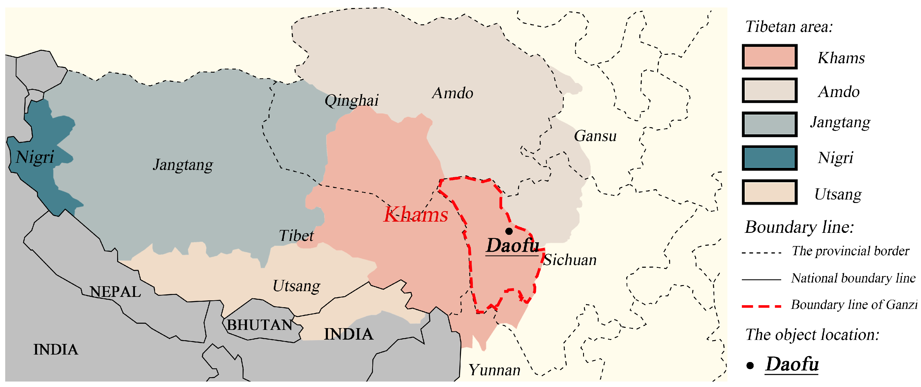
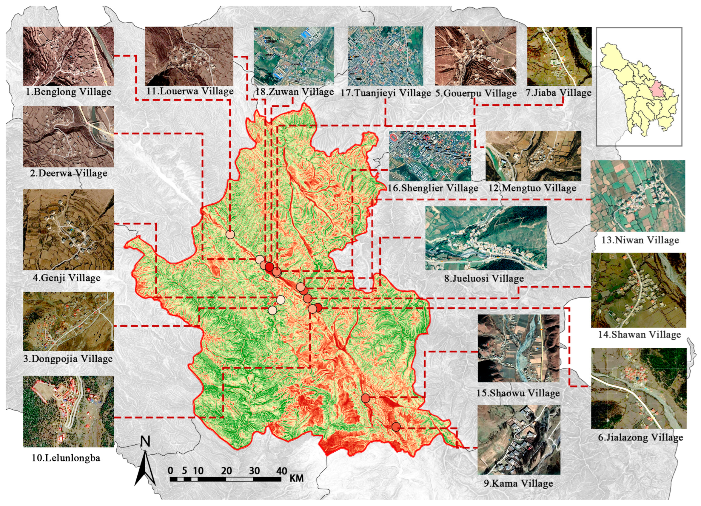
2.1. Research Region

Out of the main Tibetan regions, such as Nigri, Jangtang, Ustang, Amdo, and Kham, Kham is one of the most important in China, spanning Tibet, Sichuan, Yunnan, and Qinghai (Figure 1) [36]. In 2020, China made Ganzi Tibetan Autonomous Prefecture in Sichuan, where the Kham Tibetan region is located, one of the first demonstration cities for conservation and use of traditional villages in a concentrated and contiguous manner [37]. Most of the region is located on the Sichuan–Tibetan Plateau, with an extremely dry and cold climate, very complex terrain, and a very fragile natural ecological environment. At the same time, Kham of Ganzi has gradually seen Han Chinese culture integrated into the Tibetan area, forming a migration corridor that has facilitated the economic and cultural exchange of several ethnic groups, and as a result has developed its own unique form of settlement [38]. The distinctive regional and ethnic characteristics of the Kham Tibetan region of Ganzi make it of great value to study the spatial structure of its streets and alleys.
We conducted field research in Daofu County in the Kham Tibetan region of Ganzi Prefecture, Sichuan. It is situated along the Xianshui River rift zone on the southeastern edge of the Qinghai–Tibet Plateau and is classified as having a cold-temperate continental monsoon climate with an average altitude of 3245 m according to climate zoning [39].
Due to topographical and environmental factors, the local village pattern in Daofu is mostly scattered. To ensure that the sampled villages are fully reflective, 16 villages located along major roads and 2 villages along secondary roads were selected. The villages were measured via a drone, and the dimensions of the village buildings were measured via a theodolite. These data were loaded into the computer and were plotted via the graphics processing software CAD2014. By inserting raster images into CAD, an axial model and a ViewField model of the village samples were plotted, and the 18 village samples were numbered (Figure 2).

2.2. Application of Space Syntax
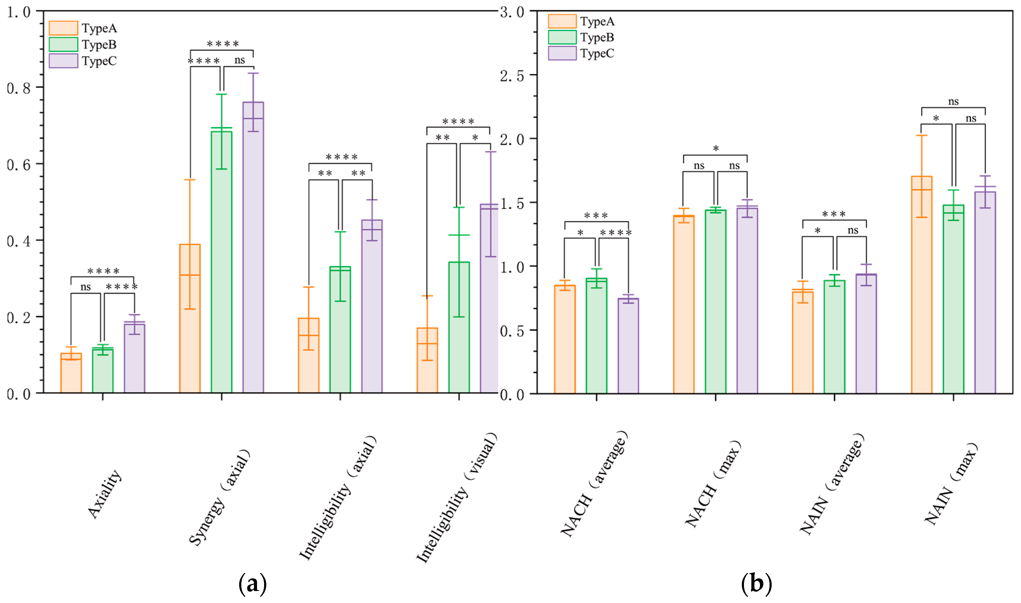
The aim of this study is to propose a mathematical and statistical approach to the analysis of the spatial derivation of traditional villages in the Kham Tibetan region of Ganzi. The theoretical and mathematical measures of space syntax employed are recognized to be applicable to the analysis of architectural, urban, and village spaces [19]. Its syntactic approach is mainly based on the transformation of spatial properties of a building, city, or village into a topological map, on the basis of which mathematical analyses and calculations are carried out [40]. The technical models are divided into four main categories: convex map, axial map, segment map, and visibility. The first syntactic analysis model is the convex space model, while the axial model uses the fewest and longest straight lines to cover the convex space, ensuring that all line segments intersect while forming a unique cycle of loops [19]. The above syntactic analysis model can be graphically represented, and various mathematical properties can be derived [19,40,41].
In this study, the main basic metrics applied to space syntax are depth, selectivity, integration, and connectivity, with the remaining being mathematical operations based on them.
Depth is the minimum number of connections that a space has to access other spaces. Choice indicates the likelihood that a space in the system will be traversed by the other shortest paths.
Integration is the degree to which a space in a system is clustered with or discrete from other spaces. The higher the degree of integration, the higher the accessibility and centrality of the space, the easier it is to gather people. Integration is also divided by level into global integration (Integration[HH]) and local integration (Integration[HH]Rn). Connectivity indicates the number of spaces that intersect in a given space in the system [19]. From these two metrics, the concepts of intelligibility and synergy can be extended. Intelligibility is the correlation coefficient between connectivity and integration[HH]; synergy is that between Integration[HH]Rn and Integration[HH]. Different intelligibility and synergy can be obtained under different syntactic models.
Angular segment analysis (ASA) based on the segment model uses the minimum number of angular turns to describe the relationship between the ends of each axis [42]. In short, the number of turns is a weighted topological relationship, thus introducing the concepts of NAIN (normalized angular integration) and NACH (normalized angular choice) for comparing the spatial configuration of cities without taking into account the influence of factors such as population [43].
The above basic measures of space syntax were derived from Depthmap software simulating the axial model and the visual field model, based on which the correlation measures of categorized spatial measures and star model of villages were further calculated to derive each syntactic index of the three groups of villages, and one-way ANOVA and Tukey’s multiple comparisons test were adopted to statistically analyze these indicators. The specific process is shown in Figure 3.

2.2.1. Axiality

Axiality is used to describe the extent to which village street spaces exhibit a rectangular orthogonal pattern, which is often characteristic of towns in the Han Chinese plains and new plains towns in China [24,44]. Hillier and Hanson [19] use the term grid axiality to describe such properties, as shown in Equation (1):
G A = ( 2 I 1 2 + 2 ) / L ,
where I indicates the number of gaps, i.e., islands, defined by the street boundary, and L indicates the number of all axes in the street network. The final result should be a value between 0 and 1, with a value closer to 1 indicating a stronger grid axis for the village streets. Its value is related to the ratio of the number of islands to that of axes, independent of the size of the grid, and thus it can be used to compare the street grid situation with different shapes and sizes. When the axiality value of a village street is equal to or greater than 0.25, it indicates a grid-like spatial pattern, while when the value is lower than 0.25, it indicates a spatial deformation of the village street [19].

2.2.2. Synergy

Synergy is defined in space syntax as the correlation coefficient between radius-3 and radius-n degrees of integration and is used to indicate the degree to which a local street space is related to the overall street space [45]. The synergy effect is also known as axial synergy because it is an axial measurement using an axial model. In addition, higher values of synergy indicate that visitors are more likely to visit nodes in the village space and are less visually disturbed by the space [46]. For traditional villages where tourism benefits are to be developed, synergy has the potential to guide planning for public spaces of special significance, as shown in Equation (2):
S y n e r g y a x i a l = n l n t _ n i I n t _ 3 i l n t _ n i I n t _ 3 i n l n t _ n i 2 ( l n t _ n i ) 2 n l n t _ 3 i 2 ( l n t _ 3 i ) 2 ,
where lnt_ni is the integration degree value of node i at the global scale, and lnt_3i is the integration degree value of node i at the local scale with a topological step of 3.

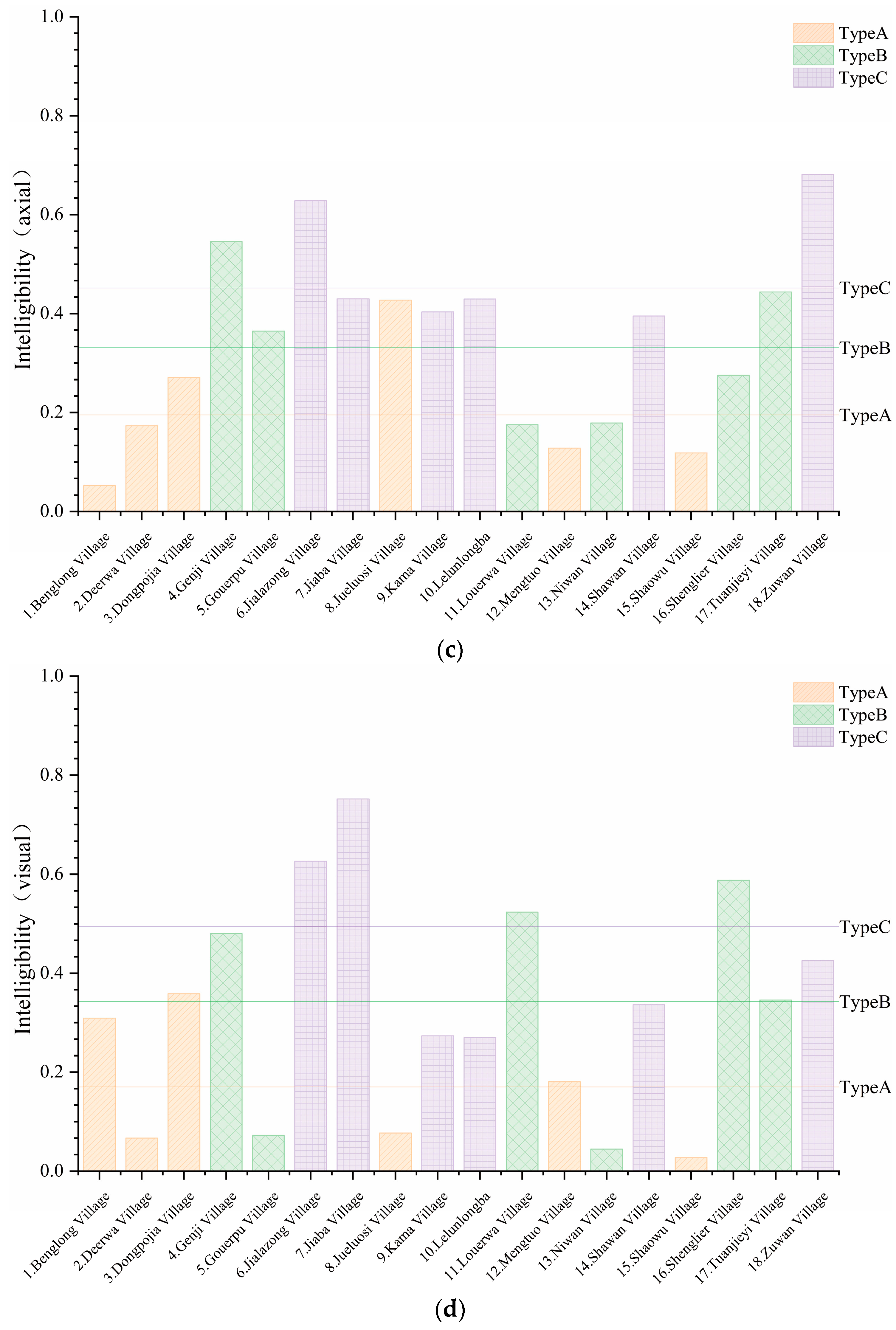
2.2.3. Intelligibility

Intelligibility is used to reflect the extent of the number of street connections that the full route has [47]. Higher intelligibility means that strangers who are unfamiliar with the village street system can explore the structure of the whole street system more easily and thus locate their own position in the village street system. The intelligibility value of this study may reflect the extent to which local villagers are aware of village construction, indicating the extent to which local managers function in the construction of villages in the Kham Tibetan region of Ganzi [24].
Intelligibility is the Pearson correlation coefficient between the space syntactic basis metric connectivity and global integration, which can be divided into intelligibility-axial and intelligibility-visual depending on the model, as shown in the Equation (3):
I n t e l l i g i b i l i t y = n C o n i I n t i C o n i I n t i n C o n i 2 ( C o n i ) 2 n l n t i 2 ( l n t i ) 2 ,
where Coni is the connectivity value of node i in the axial model or the visual field model, and lnti is the global integration value of node i in the axial or the visual field model.

2.2.4. NACH

To further exclude the influence of the number of segments on the analysis results, Hillier et al. [43] proposed the standardized series parameters of NACH and NAIN in 2012. The segment model is used to calculate the normalized angular choice (NACH) for measuring purposeful traffic, which describes the importance of the spatial units in the spatial structure of the street as traffic spaces and measures the degree of access to the space as shown in Equation (4):
NACH = log [ v a l u e ( T 1024 C h o i c e   R n   m e t r i c ) + 1 ] log [ v a l u e ( T 1024   Total   Depth   Rn   metric ) + 3 ] ,
where T1024Choice Rn metric is the value of segment model selectivity at a scale distance of radius n, and T1024Total Depth Rn metric is the value of the overall depth of the segment model at a scale distance of radius n. In this study, most of the village pedestrians are on foot, so the values of n in this paper are taken to be 400 m, which can be reached by pedestrians in three minutes. The results indicate a low space use efficiency when 0 < NACH < 0.3, a moderate space use efficiency when 0.3 < NACH < 0.5, and a high space use efficiency when NACH > 0.5.

2.2.5. NAIN

Normalized angular integration (NAIN), also known as the degree of penetration, is used to measure the accessibility of a space by describing its importance as a destination space in a model of the spatial structure of a street, as shown in Equation (5):
NAIN = [ v a l u e ( T 1024 Node   Count   Rn   metric ) ] 1.2 v a l u e ( T 1024 Total   Depth   Rn   metric ) + 2 ,
where T1024Node Count Rn metric is the value of a node in the line segment model at a scale distance of radius n, and T1024Total Depth Rn metric is the value of the overall depth of the line segment model at a scale distance of radius n. The results indicate a low space use efficiency when 0 < NAIN < 0.3, a moderate space use efficiency when 0.3 < NAIN < 0.5, and a high space use efficiency when NAIN > 0.5.
Based on NACH and NAIN, Hillier et al. [43] proposed a quadrangular star model that describes the background network of the city in terms of the Y-axis associated with mean NACH and mean NAIN and the foreground network in terms of the X-axis associated with maxNACH and maxNAIN, and elaboration was made in 2016 [48]. In simple terms, the city or village is seen as a binary structure consisting of foreground and background, and the strength of the foreground and background network can be measured in order to understand the planning and organic nature of the city or village.

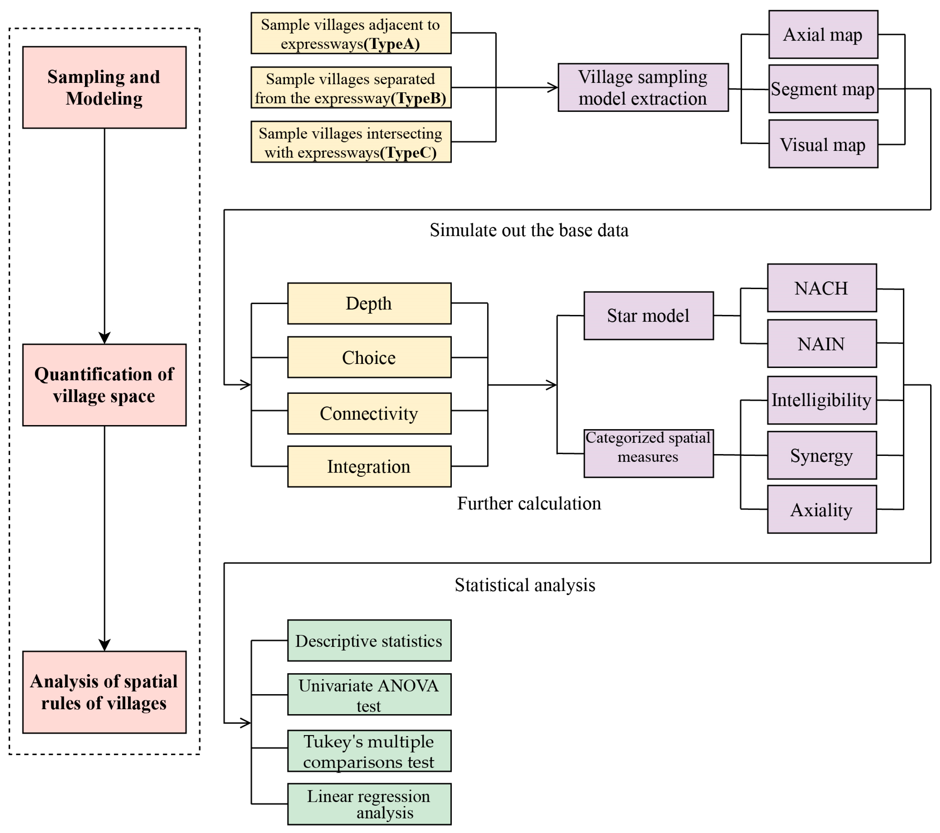
2.3. Data Analysis Methods
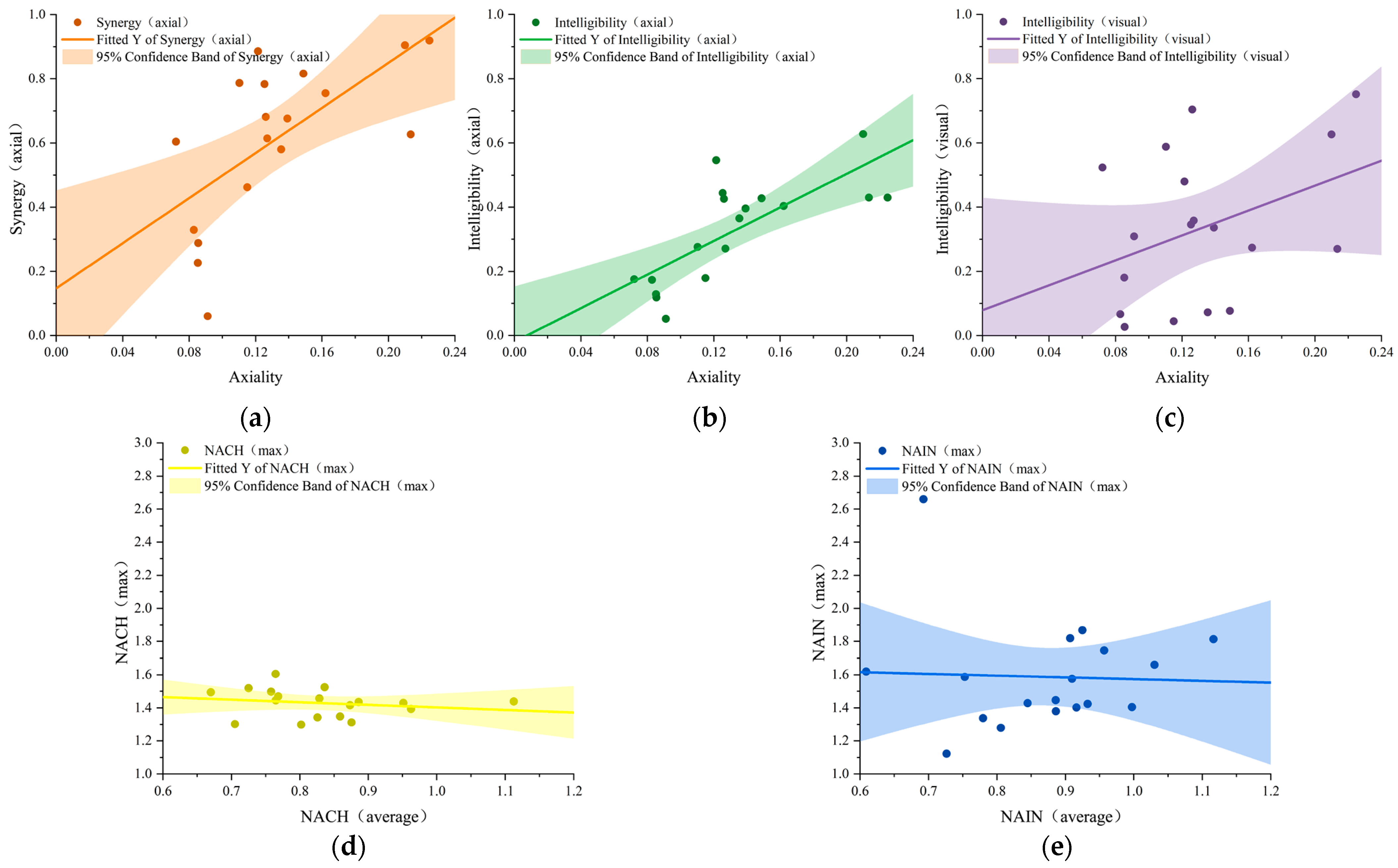
The values of axiality, intelligibility-axial, intelligibility-visual, and synergy-axial for all village samples were obtained via the above method, and detailed analysis was conducted for comparison. In addition, the values of NACH and NAIN are derived from the line model, and a star model is drawn to explore the future development pattern of traditional villages in the Kham Tibetan region of Ganzi. A one-way ANOVA was conducted via SPSS software by dividing all samples into three categories—a sample of villages adjacent to the urban expressway (Type A), a sample of villages away from the urban expressway (Type B), and a sample of villages intersecting the urban expressway (Type C), to determine whether the urban expressway would have a significant impact on Daofu villages, which were subsequently subject to multiple comparisons for finding out exactly which two differed from each other.
On the one hand, we have carried out a large number of actual surveys and mapping to establish a model of the axes and view areas of traditional villages, which provides a valid and reliable database for this paper. On the other hand, the quantitative processing of traditional villages through software to obtain threshold values of factors affecting the change of traditional village streets can also provide some reference for the government to actually protect traditional villages. The above methods make the study more convincing.

3. Results

3.1. Phase 1: Categorized Spatial Measures
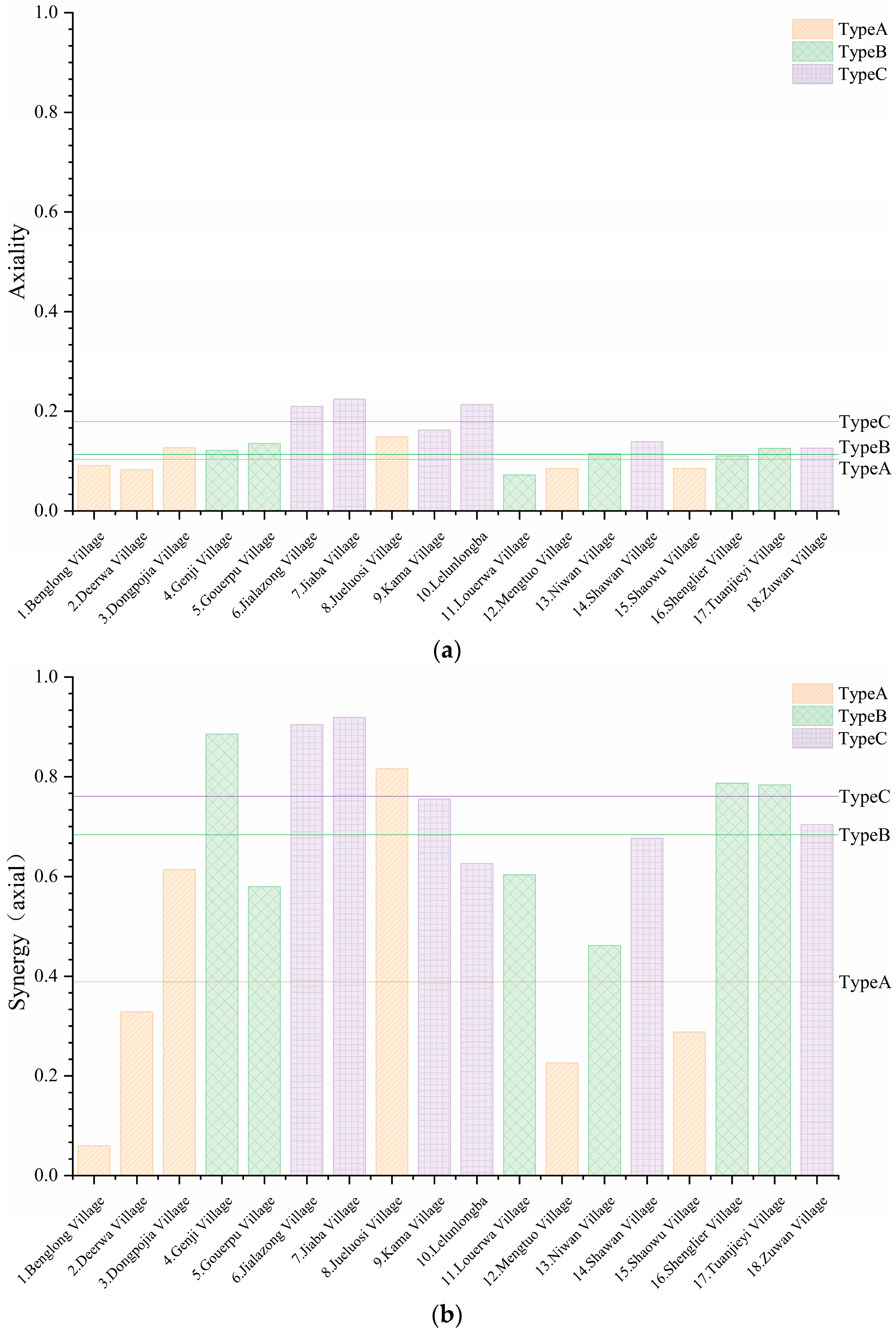
Figure 4 shows the categorical spatial metrics for the three groups of case studies in the two selected categories.

3.1.1. Axiality

In the sample of Tibetan villages classified according to their relationship with urban arterial roads, villages intersecting urban expressways (Type C) showed higher axiality (mean value of 0.179), while villages adjacent to urban expressways (Type A) and villages away from urban expressways (Type B) showed small differences in axiality, i.e., 0.103 and 0.113, respectively. This may be due to the fact that villages intersecting urban expressways are often built in close proximity to urban roads, i.e., urban expressways are used as the central axis of villages, which extend around urban roads in both directions. It is also clear from Figure 5 that the Type C sample of villages is mostly from the plains, as the flat terrain is more conducive for village managers to plan the order of villages [49].
When axiality exceeds 0.25, it indicates the presence of a reticulated urban model system in the village. The mean value for the overall sample was 0.132, and of the 18 villages selected, none had an axiality above 0.25. Only Jialazong Village (0.210), Jiaba Village (0.225), and Lelunlongba (0.213) from Type C had axiality close to this. These three villages have a more compact layout and fewer redundant branching offsets on the outer edge of them than the other three samples in Type C, and they are certainly more dependent on the axial role of urban arterial roads.
It is noteworthy that only Shaowu Village from Type A had an axiality below 0.1 within the plain villages, because although this village is not constrained by topography, the river within it divides the village into three scattered parts, making it difficult for it to develop in a concentrated manner to create a significant axiality.

3.1.2. Synergy

In sample comparison within Daofu villages, the sampled villages intersecting the urban expressway (Type C) and the sampled villages away from the urban expressway (Type B) had high synergy-axial mean values of 0.761 and 0.684, respectively, and the sampled villages adjacent to the urban expressway (Type A) had the synergy-axial mean value of 0.389 (the smallest).
The first two samples (Type C and Type B) impose less spatial disturbance for visitors to reach the village street nodes thanks to their proximity to the main town or to the flatter areas at the foot of the hill. The sampled villages adjacent to urban expressways (Type A), on the other hand, are usually smooth areas where urban roads are at the foot of hills, and the villages are only distributed along that side toward the hills, making them more complex in terms of vertical distribution and less accessible for visitors to their nodal spaces.
The mean value of synergy-axial for the whole sample of Daofu is 0.611, which is a good level. Jialazong Village and Jiaba Village from Type C have high values of synergy-axial, i.e., 0.905 and 0.919, respectively, and more regularity in village layout is, to a certain extent, conducive to better accessibility of street space. It is noteworthy that the lowest value for synergy-axial is 0.06, i.e., the figure for Benglong Village of Type A, which is much smaller than the Type A average. The village is bisected by a river, with many side roads but few houses, and the internal roads are long and winding, which makes access more difficult.

3.1.3. Intelligibility

Intelligibility is used to describe the relationship between the part and the whole in a village street. The intelligibility-axial mainly studies the relationship between the part and the whole of the street abstracted as an axis, without considering the specific spatial size of the street, etc. The intelligibility-visual complements the relationship between the parts of the street space and the whole by using a grid to divide the street space into multiple pixel grids, and its connectivity means the number of pixel grids that can be seen from one pixel grid to the other. The grid size chosen for this paper is 2 m × 2 m (Table 1).
The mean values of intelligibility-axial and intelligibility-visual are very close to each other, i.e., 0.326 and 0.335, respectively, and the mean sizes of the classified samples are consistent, i.e., Type C > Type B > Type A.
In terms of intelligibility-axial, Type B’s intelligibility-axial mean is the closest to the overall sample mean of 0.331. The other two samples (Type A and Type C) have intelligibility-axial means of 0.195 and 0.452, respectively. The same is true for intelligibility-visual, with Type B’s intelligibility-visual mean being close to the overall sample mean of 0.342. The intelligibility-visual means for Type A and Type C are 0.170 and 0.494, respectively.
A closer look at the reasons for this reveals that topographical distribution of villages in Type B is consistent with that of the overall samples, i.e., half from the plains and half from the mountains. In contrast, samples in Type C mostly have high degrees of axiality, with village managers consciously controlling village sprawl and imposing a strong sense of boundaries for the villages, resulting in a significant reduction in the number of isolated village sheep paths compared to those of the other two samples. Additionally, their grid-like layout makes the villages more readable.
Interestingly, individual samples do not show consistency in intelligibility-axial and intelligibility-visual. For example, Benglong Village from Type A has the lowest intelligibility-axial value (0.052) and an intelligibility-visual value close to the overall sample mean (0.309). Gouerpu Village from Type B, on the other hand, has a higher intelligibility-axial value (0.365) and a lower intelligibility-visual value (0.073). The former is more scattered, with long, winding streets, which makes it easy to create nodes at the junctions of streets but difficult for pedestrians to understand; however, the presence of nodes makes the streets themselves easy to be speculated about. The latter is not disturbed by the river, and the street network is more compact. As there are two urban arteries running through the village, the few houses in the village are distributed directly along the arteries, and the streets themselves are simpler in form, but the small number and length of the streets make it difficult for pedestrians to understand the street form of the village from the visual space.

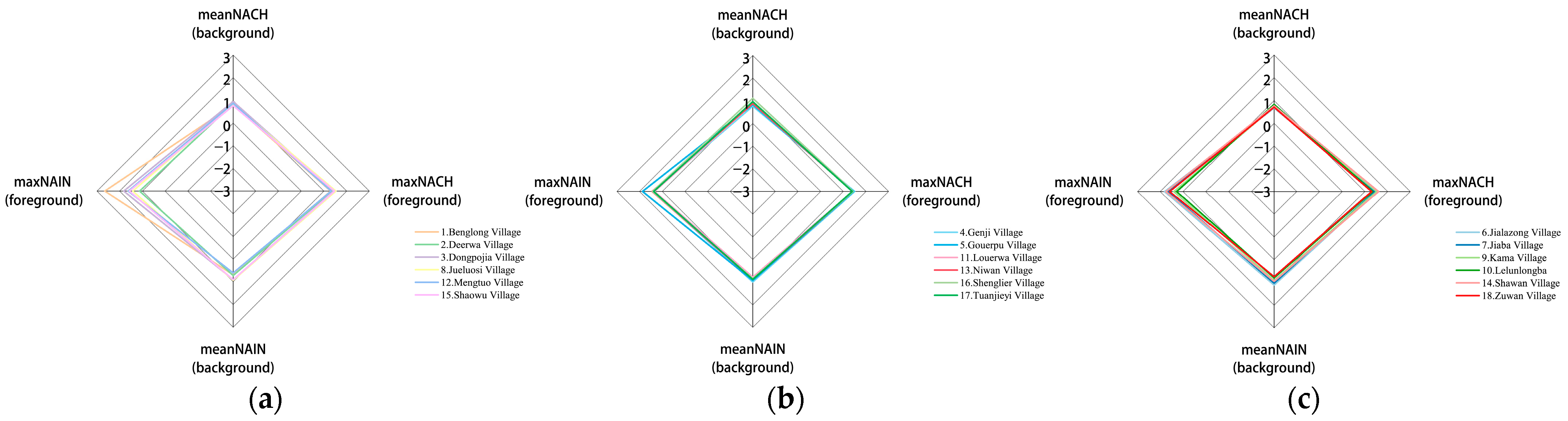
3.2. Phase 2: Star Model Analysis

Figure 6 shows a star model for sampled villages (Type A, Type B, Type C) within Daofu villages classified by their relationship to urban expressways, which shows that the values of max NACH, mean NACH, and mean NAIN all hover around 1, except for the large variation in max NAIN values, where the sample from Type A Benglong Village has a much higher max NAIN value (2.660) than the rest of the sample. The other villages with high max NAIN values are Gouerpu Village (1.867) from Type B and Jialazong Village (1.813) from Type C, which also feature similarly high mean NAIN values of 0.925 and 1.116, respectively, compared to the latter two. Benglong Village has the lowest mean NAIN value (0.693) among the overall sample. This suggests that Benglong Village has a high foreground network and a solid village structure but is still far from the latter two in terms of background networks and needs to develop toward regularity and integration.
A closer look at the specific values of the three sample groups reveals that in the star model, except for the mean NACH value and max NAIN, there is still a relationship of Type C overall value > Type B overall value > Type A overall value among the three, but none of the specific values are very different.
Most of the sampled villages from Type A have max NACH values below 1.4, contradicting Hillier et al.’s [43] 2012 observation that “no real system has a maximum (max NACH value) below 1.4”. Meanwhile, Liao et al. [24] have unveiled similar findings in their study of Chinese historical towns. As a whole, Type A is very deficient in both foreground and background networks compared to the other two samples, and the villages suffer from severe deformations in street spatial patterns due to topography and rivers, for example. Interestingly, the villages classified according to the different relationships of urban roads in the background and foreground networks have very different NACH and NAIN values. For example, Type A with the lowest mean max NACH value (1.396) has the highest mean max NAIN value (1.703). Type C, which has the highest mean NAIN value (0.930), has the lowest mean NACH value (0.743). This suggests that Type A and Type C villages have low hurdles of access to some or all of the streets, while the streets are very accessible.
In addition, we conducted an ANOVA test (Table 2) and Tukey’s multiple comparisons test (Figure 7). This was to examine the differences between and within groups, as well as the significance of the differences between the specific two groups of samples. In the ANOVA test, we found significant differences in five aspects: axiality, synergy-axial, intelligibility-axial, intelligibility-visual, and mean NACH. In a further Tukey’s multiple comparisons test, we found that the most significant differences existed mainly for Type A–Type C and Type B–Type C for axiality values, Type A–Type B and Type A–Type C for synergy-axial values, Type A–Type C for intelligibility-axial values, Type A–Type C for intelligibility-visual values, Type B–Type C for mean NACH values, intelligibility-axial values of Type A–Type C, intelligibility-visual values of Type A–Type C, and mean NACH values of Type B–Type C. Due to the small sample size of each group, accuracy of the results needs to be further tested, but the above tests still show differences in the spatial pattern of different sampled villages.

4. Discussion

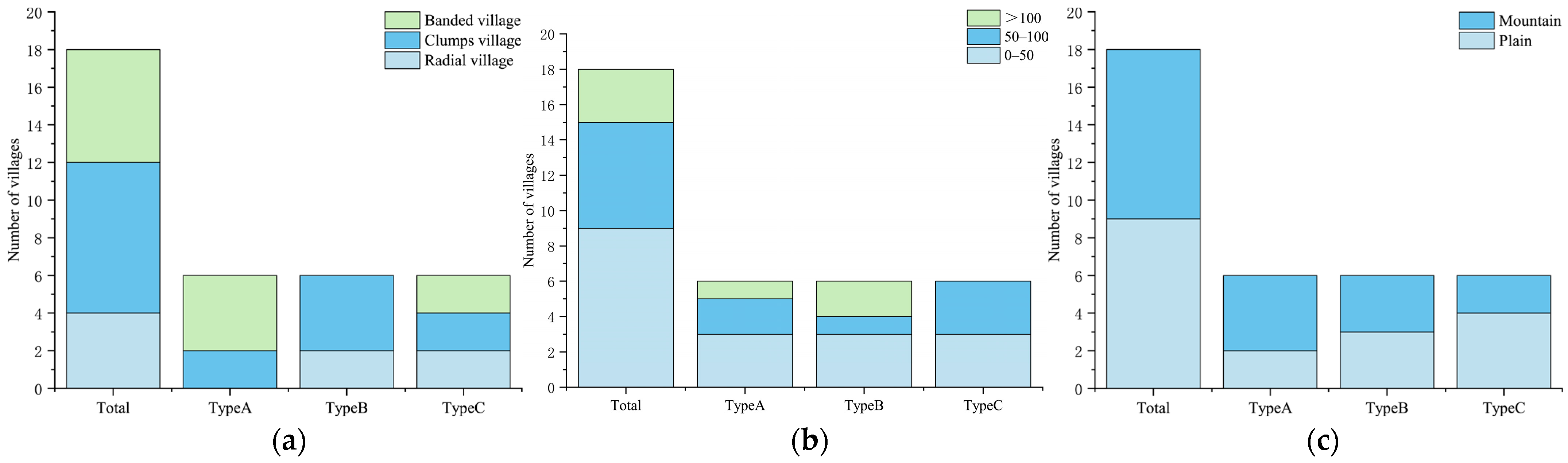
4.1. Traditional Village Classification as per Roads

Based on their relationships to urban expressways, the spatial layout types of Daofu villages fall into three main categories, namely, adjacent, detached, and intersecting. The results of our analysis further reveal the street forms of the traditional villages of Daofu in these three patterns, and mathematical methods reveal how they are affected in which metric. As can be seen from the results, the traditional villages of Daofu hardly have their own main axes, but when the urban arterial road passes through the village, the village uses it as an axis to spread outwards, and there are also subtle differences between the adjacent and the detached samples without main axis synergy-axial equivalents. Therefore, we propose three spatial patterns based on these mathematical metrics: axis-free adjacent type, axis-free detached type, and axis-intersected type. The thresholds for each data point of the different types of village samples are also shown in detail in Table 3 and Table 4, which provide reference indicators for future reconstruction and restoration of Daofu villages.

4.2. The Spatial Measurement Relationship of Villages

In addition, axiality has been suggested as a key metric for linking the remaining measures in the paper by Liao et al. [24]. We therefore further investigated the relationship between axiality and several other data types in the categorical measure and between the NACH and NAIN means and maxima in the star model through line fitting.
As shown in Figure 8, the Pearson correlation coefficients of axiality and synergy-axial, intelligibility-axial, and intelligibility-visual are 0.647, 0.746, and 0.378, respectively. On the whole, axiality is positively correlated with the other categorical measures; specifically, it is correlated to a greater extent with the first two, because axiality is linearly related to synergy-axial and intelligibility-axial in describing traditional village streets, while intelligibility-visual is a measure of street space from the perspective of street view. The linear regression models of mean NACH vs. max NACH and mean NAIN vs. max NAIN in the star model are shown in the lower level, with Pearson correlation coefficients of −0.193 and −0.040, respectively, both showing a low degree of negative correlation. This suggests that a higher background network does not mean a higher foreground network in traditional villages in Daofu and that there may be great potential for disorderly villages to develop in better order.
The first stage of the classification metric shows that the relationship between the urban expressway and the traditional village of Daofu influences the indicators of street space, with adjacency and intersection guiding the village in two very different directions. Villages that intersect urban expressways and can form axiality have better access and synergy effects. The second stage of the star model shows that urban expressways have less impact on the foreground and background networks of different types of villages, with the exception of mean NACH. This may be caused by the fact that the village samples are all in the same environmental context.

4.3. The Influence of Chieftain System on Villages

The native chieftain system was a form of rule developed by feudal rulers in ancient China to strengthen their control over minority areas in the southwest [50]. The chieftain was the ruler of a local tribe or a region, and the land was owned by him. The people cultivated his land and paid him for food. At the same time, the chieftain also ruled the people in alliance with the local monks, always maintaining his political, military, and economic independence. Under the native chieftain system, the Tibetan areas of Kham were divided into different chieftains under the jurisdiction of different “Tu” or “Tun”. The identity of the inhabitants is relatively fixed. To a certain extent, the village space has a symbolic role to play. For example, Jialazong Village (with an axiality value of 0.210) and Lelunlongba (with an axiality value of 0.213), which have high axiality values, are closely distributed with temples at the core of the village.

4.4. Limitations of Village Samples

This study has inevitable limitations. Firstly, 18 sampled villages within the boundaries of Daofu were selected for analysis in this study and were divided into three groups as per their relationships with the urban arterial roads. This classification process is relatively crude and may allow for ambiguity in some definitions, e.g., in the sample of villages adjacent to urban expressways (Type A), village morphology can still be subdivided into strips and clusters, and the areas in which they are located are distinguished between plains and mountains. And there may be some degree of superimposition of influencing factors. Although no significant differences were found in the ANOVAs tested afterwards, it is uncertain whether there is an enhancing effect of factor superimposition on the results. Secondly, the sample of six villages per group also makes the statistical significance of this study a bit limited. However, when looking at studies of space syntax, it is typical to use four to six cases to analyze spatial studies. For example, Omer et al. [51] studied the development patterns of Israeli streets, dividing urban development into three periods, with five sample cases selected for each period. Liao et al. [24], who studied historical Chinese towns, also divided the study sample into three groups of four to five sample cases each. Therefore, the number of cases in this study can guarantee the validity of the results.

5. Conclusions

In this study, a two-stage quantitative analysis was conducted via the space syntax method to explore spatial patterns of the streets of traditional villages in Daofu. A sample of six villages away from urban expressways was chosen as a benchmark to compare with traditional villages adjacent to or intersecting urban expressways in terms of spatial structure.
This study first introduces four spatial measures for mapping relevant spatial models of selected traditional villages. Specifically, Type C (intersecting urban expressways) had higher axiality, synergy-axial, intelligibility-axial, and intelligibility-visual values compared to samples adjacent to or away from urban expressways. In the meantime, axiality was found to be positively correlated with synergy-axial, intelligibility-axial, and intelligibility-visual in general.
We then constructed star models for the three sample groups to analyze the spatial structure of selected traditional villages. The results show that there is no significant difference between the foreground and background networks of the three sample groups of villages, except for mean NACH. In this, the sample of villages from Type A (adjacent to the urban expressway) features max NACH mostly less than 1.4, indicating that Type A is more irregular compared to the other two village samples. We also found a somewhat negative correlation between the mean and maximum values of NACH and NAIN, i.e., with decreasing maximum value comes increasing mean value.
On the basis of the above study, we proposed three types of spatial patterns for the classification of Daofu traditional villages: axis-free adjacent, axis-free detached, and axis-intersected. We also explored the thresholds for each spatial pattern measure of Daofu traditional villages under different classifications.
In general, villages intersecting urban expressways are more systematically distributed along the axis of the expressway, and their accessibility is also more likely to bring tourism and commercial value to the villages. However, the spatial structure of villages adjacent to urban expressways will instead become more disorganized and the streets more unfavorable for pedestrians to understand and use due to the influence of urban expressways. In the case where the background and foreground networks are not obvious, we suggest that the managers of traditional villages integrate the development and restoration of villages with urban expressways in order to facilitate the generation of a village network.
It is worth noting that space syntax itself has certain limitations, as it focuses on the purely typological revealing space, ignoring the commercial, cultural, educational, and entertainment functions carried by the streets themselves. The analysis of village or urban planes only excludes the influence of 3D topography on the various classification measures.
However, space syntax has undergone more than 40 years of research and development, driven by Hillier et al. Its validity and reliability have been proven and widely accepted via international research [52]. These limitations do not offset the significant advantages of the methodology proposed in this study in terms of exploring traditional villages and understanding their spatial composition.
In addition, there is still some room for development to further argue for factors that differentiate space syntax from the existence of specific human behavior in reality. The factors influencing spatial variation of streets and alleys within traditional villages in the same or in different regions can also be further explored to identify the other relevant or deterministic factors.

Author Contributions

Conceptualization, N.X. and B.C.; methodology, N.X.; software, N.X.; validation, N.X. and B.C.; formal analysis, N.X.; investigation, N.X.; resources, B.C.; data curation, N.X.; writing—original draft preparation, N.X.; writing—review and editing, N.X.; visualization, N.X.; supervision, B.C.; project administration, N.X.; funding acquisition, B.C. All authors have read and agreed to the published version of the manuscript.

Funding

This research was funded by the key R & D project in the field of social development in Sichuan Province in 2020, project name: “Research on Green Livable Performance Improvement Technology of the Northwest Sichuan Plateau Villages and Towns”, No. 2020YFS0308.

Institutional Review Board Statement

Not applicable.

Informed Consent Statement

Not applicable.

Data Availability Statement

Not applicable.

Acknowledgments

We thank the local residents of Daofu for their support for this study.

Conflicts of Interest

The authors declare no conflict of interest.

References

  1. Hu, Y.; Chen, S.; Cao, W.; Cao, C. The concept and cultural connotation of traditional villages. Urban Dev. Stud. 2014, 21, 11–13. [Google Scholar]
  2. Yu, B.; Lu, Y.; Zeng, J.; Zhu, Y. Progress and prospect on rural living space. Sci. Geogr. Sin. 2017, 37, 375–385. [Google Scholar]
  3. Klokov, K. Substitution and Continuity in Southern Chukotka Traditional Rituals: A Case Study from Meinypilgyno Village, 2016–2017. Arct. Anthropol. 2018, 55, 117–133. [Google Scholar] [CrossRef]
  4. Ghosh, M.; Banerjee, A. Traditional Folk Art Community and Urban Transformation: The Case of the Artists’village at Kalighat, India. J. Archit. Plan. Res. 2019, 36, 70. [Google Scholar]
  5. Prasiasa, D.P.O.; Widari, D. Traditional Agricultural System as Tourism Icon in Jatiluwih Tourism Village, Tabanan Regency, Bali Province. J. Asian Dev. 2019, 5, 89–100. [Google Scholar] [CrossRef]
  6. Fu, J.; Zhou, J.; Deng, Y. Heritage values of ancient vernacular residences in traditional villages in Western Hunan, China: Spatial patterns and influencing factors. Build. Environ. 2021, 188, 107473. [Google Scholar] [CrossRef]
  7. Liu, T.; Liu, P.; Wang, L. The protection and tourism development path of ancient villages and old towns under the background of new-type urbanization: A case study of old town of Xuanzhou in Hunan province. Geogr. Res. 2019, 38, 133–145. [Google Scholar]
  8. Liu, P. The theory and practice exploration of “remembering nostalgia” in the construction of new urbanization. Geogr. Res. 2015, 34, 1205–1212. [Google Scholar]
  9. Liu, C.; Xu, M. Characteristics and Influencing Factors on the Hollowing of Traditional Villages-Taking 2645 Villages from the Chinese Traditional Village Catalogue (Batch 5) as an Example. Int. J. Environ. Res. Public Health 2021, 18, 12759. [Google Scholar] [CrossRef]
  10. Qi, W.; Li, L.; Zhong, J.; Wu, G. Value Preferences and Intergenerational Differences of Tourists to Traditional Chinese Villages. Discret. Dyn. Nat. Soc. 2021, 2021, 9059164. [Google Scholar] [CrossRef]
  11. Duan, J.; Jie, M. Analysis of the Space in Hongcun Ancient Village of the World Cultural Heritage; Southeast University Press: Nanjing, China, 2009. [Google Scholar]
  12. Duizhen, L. Introduction to Chinese Dwellings; Architectural Engineering Press: Beijing, China, 1956. [Google Scholar]
  13. Zhongyi, Z. Huizhou Ming Dynasty Residence; Architectural Engineering Press: Beijing, China, 1957. [Google Scholar]
  14. Yigang, P. Landscape Analysis of Traditional Villages and Towns; China Architecture and Architecture Press: Beijing, China, 1992. [Google Scholar]
  15. Liangyong, W. Introdution to Sciences of Human Settlements; China Architecture and Architecture Press: Beijing, China, 2001. [Google Scholar]
  16. Chen, X.; Xie, W.; Li, H. The spatial evolution process, characteristics and driving factors of traditional villages from the perspective of the cultural ecosystem: A case study of Chengkan Village. Habitat Int. 2020, 104, 102250. [Google Scholar] [CrossRef]
  17. Pei, Y.; Gong, K.; Leng, J. Study on the inter-village space of a traditional village group in Huizhou Region: Hongguan Village group as an example. Front. Archit. Res. 2020, 9, 588–605. [Google Scholar] [CrossRef]
  18. Ying, T.; Zhou, Y. Community, governments and external capitals in China’s rural cultural tourism: A comparative study of two adjacent villages. Tour. Manag. 2007, 28, 96–107. [Google Scholar] [CrossRef]
  19. Hillier, B.; Hanson, J. The Social Logic of Space; Cambridge University Press: Cambridge, UK, 1989. [Google Scholar]
  20. Hillier, B.; Penn, A.; Hanson, J.; Grajewski, T.; Xu, J. Natural Movement: Or, Configuration and Attraction in Urban Pedestrian Movement. Environ. Plan. B Plan. Des. 1993, 20, 29–66. [Google Scholar] [CrossRef]
  21. Giannopoulou, M.; Roukounis, Y.; Stefanis, V. Traffic Network and the Urban Environment: An Adapted Space Syntax Approach. Procedia—Soc. Behav. Sci. 2012, 48, 1887–1896. [Google Scholar] [CrossRef] [Green Version]
  22. Lebendiger, Y.; Lerman, Y. Applying space syntax for surface rapid transit planning. Transp. Res. A Policy Pract. 2019, 128, 59–72. [Google Scholar] [CrossRef]
  23. Eldiasty, A.; Sabry Hegazi, Y.; El-Khouly, T. Using space syntax and TOPSIS to evaluate the conservation of urban heritage sites for possible UNESCO listing the case study of the historic centre of Rosetta, Egypt. Ain Shams Eng. J. 2021, 12, 4233–4245. [Google Scholar] [CrossRef]
  24. Liao, P.; Gu, N.; Yu, R.; Brisbin, C. Exploring the spatial pattern of historic Chinese towns and cities: A syntactical approach. Front. Archit. Res. 2021, 10, 598–613. [Google Scholar] [CrossRef]
  25. Xu, Y.; Yuan, B.; Zhang, H. Research on the renovation of Longtan Village in Guizhou Province based on spatial syntax. E3S Web Conf. 2021, 233, 01116. [Google Scholar] [CrossRef]
  26. Sun, S.; Li, Z.; Gao, D. Analysis of Streets and Lanes of Traditional Villages in Nanyuan of Zhuozhang River Basin Based on Space Syntax. In Proceedings of the 7th International Conference on Architecture, Materials and Construction—ICAMC; Springer: Cham, Switzerland, 2021; Volume 226, pp. 275–285. [Google Scholar]
  27. Zhang, C. (Ed.) Discussion on Architectural Form of Ganbao Tibetan Village in the Multi-Ethnic Integration Area. In 2019 International Conference on Architecture: Heritage, Traditions and Innovations (AHTI 2019); Atlantis Press: Paris, France, 2019. [Google Scholar]
  28. Qin, Z.; Yang, B. (Eds.) Research of Protection and Development of Regional Culture Against the Background of Tourism Development: Taking Jiaju Tibetan Village, Danba County, Sichuan Province as an Example. In 4th International Conference on Culture, Education and Economic Development of Modern Society (ICCESE 2020); Atlantis Press: Paris, France, 2020. [Google Scholar]
  29. Meng, Q.; Wang, C.; Xu, T.; Pi, H.; Wei, Y. Evaluation of the Sustainable Development of Traditional Ethnic Village Tourist Destinations: A Case Study of Jiaju Tibetan Village in Danba County, China. Land 2022, 11, 1008. [Google Scholar] [CrossRef]
  30. Songlin, S.; Xin, P.; Chengcai, H.; Yuliang, Y. Living Close to Buddha: Influence of Mandala on Landscape Spatial Pattern of Tibetan Settlements Around Xiba Temple. China City Plan. Rev. 2022, 31, 48–56. [Google Scholar]
  31. Zhang, S.; Zhao, K.; Ji, S.; Guo, Y.; Wu, F.; Liu, J.; Xie, F. Evolution characteristics, eco-environmental response and influencing factors of production-living-ecological space in the Qinghai–Tibet Plateau. Land 2022, 11, 1020. [Google Scholar] [CrossRef]
  32. Zhang, Y.; Li, J. A Study on the Spatial Characteristics of Jiarong Tibetan Settlements Based on the Theory of Pattern Language. CONVERTER 2021, 471–483. [Google Scholar] [CrossRef]
  33. Zhang, Y.; Baimu, S.; Tong, J.; Wang, W. Geometric spatial structure of traditional Tibetan settlements of Degger County, China: A case study of four villages. Front. Archit. Res. 2018, 7, 304–316. [Google Scholar] [CrossRef]
  34. Zhang, B.; Tang, B.; Zhou, L.; Huang, K. Study on the Influence of Road Network on the Spatial Distribution of Tourism Resources–A Case Study of the Sichuan-Tibet Scenic Byway. CONVERTER 2021, 242–256. [Google Scholar] [CrossRef]
  35. Jin, L.; Wang, Z.; Chen, X. Spatial Distribution Characteristics and Influencing Factors of Traditional Villages on the Tibetan Plateau in China. Int. J. Environ. Res. Public Health 2022, 19, 13170. [Google Scholar] [CrossRef]
  36. Fischer, A.M. “Population invasion” versus urban exclusion in the Tibetan areas of western China. Popul. Dev. Rev. 2008, 34, 2631–2662. [Google Scholar] [CrossRef]
  37. Public Announcement of Evaluation Results of Demonstration City for Centralized Protection and Utilization of Traditional Villages in 2020. Available online: http://www.chuantongcunluo.com/index.php/Home/search/details/id/2311.html (accessed on 2 June 2020).
  38. Wei, L.I.; Mao, W. Study of spatial structure of urban system in ecology-vulmerable regions in northeastern periphery of Tibetan plateau. J. Glaciol. Geocryol. 2011, 6, 1427–1434. [Google Scholar]
  39. Gao, Z.-j.; Li, Z.-d.; Lu, Z.-m.; Yang, J.-s. Morphological characteristics and comprehensive evaluation of the Bamei mylonite hoodoos in Daofu County, Sichuan. East China Geol. 2016, 229–234. [Google Scholar] [CrossRef]
  40. Hanson, J. Decoding Homes and Houses; Cambridge University Press: Cambridge, UK, 2003. [Google Scholar]
  41. Ostwald, M.J. The Mathematics of Spatial Configuration: Revisiting, Revising and Critiquing Justified Plan Graph Theory. Nexus Netw. J. 2011, 13, 445–470. [Google Scholar] [CrossRef]
  42. Turner, A. Angular Analysis: A Method for the Quantification of Space; Centre for Advanced Spatial Analysis: London, UK, 2000. [Google Scholar]
  43. Hillier, W.; Yang, T.; Turner, A. Normalising least angle choice in Depthmap-and how it opens up new perspectives on the global and local analysis of city space. J. Space Syntax. 2012, 3, 155–193. [Google Scholar]
  44. Xiong, H.; Payne, D. Characteristics of Chinese rural networks: Evidence from villages in central China. Chin. J. Sociol. 2017, 3, 74–97. [Google Scholar] [CrossRef]
  45. Hillier, B. Space Is the Machine: A Configurational Theory of Architecture; Space Syntax: London, UK, 2007. [Google Scholar]
  46. Li, Y.; Xiao, L.; Ye, Y.; Xu, W.; Law, A. Understanding tourist space at a historic site through space syntax analysis: The case of Gulangyu, China. Tour. Manag. 2016, 52, 30–43. [Google Scholar] [CrossRef]
  47. Hillier, B.; Burdett, R.; Peponis, J.; Penn, A. Creating life: Or, does architecture determine anything? Archit. Comport./Archit. Behav. 1986, 3, 233–250. [Google Scholar]
  48. Hillier, B. What are cities for? And how does it relate to their spatial form? J. Space Syntax. 2016, 6, 199–212. [Google Scholar]
  49. Hole, F.; Flannery, K.V.; Neely, J.A. Prehistory and Human Ecology of the Deh Luran Plain: An Early Village Sequence from Khuzistan, Iran; University of Michigan Museum of Anthropological Archaeology: Ann Arbor, MI, USA, 1969; Volume 1. [Google Scholar]
  50. Herman, J.E. Empire in the southwest: Early Qing reforms to the native chieftain system. J. Asian Stud. 1997, 56, 47–74. [Google Scholar] [CrossRef]
  51. Omer, I.; Zafrir-Reuven, O. The Development Of Street Patterns In Israeli Cities. J. Urban Reg. Anal. 2020, 7, 113. [Google Scholar] [CrossRef]
  52. Shatu, F.; Yigitcanlar, T.; Bunker, J. Shortest path distance vs. least directional change: Empirical testing of space syntax and geographic theories concerning pedestrian route choice behaviour. J. Transp. Geogr. 2019, 74, 37–52. [Google Scholar] [CrossRef]
Figure 1. Tibetan cultural areas and the location of the study area.
Sustainability 15 03513 g001
Figure 2. Distribution of village samples.
Sustainability 15 03513 g002
Figure 3. Research method flow chart.
Sustainability 15 03513 g003
Figure 4. Categorized spatial measure analytical results. (a) Describes the axiality values of different villages of Daofu and the mean values of different samples; (b) Describes the synergy-axial values of different villages of Daofu and the mean values of different samples; (c) Describes the intelligibility-axial values of different villages of Daofu and the mean values of different samples; (d) Describes the intelligibility-visual values of different villages of Daofu and the mean values of different samples.
Sustainability 15 03513 g004aSustainability 15 03513 g004b
Figure 5. Condition of sample. Schemes: (a) The distribution of sample shapes; (b) The distribution of sample houses; (c) The distribution of sample terrains.
Sustainability 15 03513 g005
Figure 6. Star models of space syntax. (a) Star model of Type A; (b) Star model of Type B; (c) Star model of Type C.
Sustainability 15 03513 g006
Figure 7. Tukey’s multiple comparisons test samples. (a) Tukey’s multiple comparisons test of categorized spatial measures; (b) Tukey’s multiple comparisons test of star model analysis. (ns stands for no significant difference; * stands for p < 0.05; ** stands for p < 0.005; *** stands for p < 0.001; **** stands for p < 0.0001.)
Sustainability 15 03513 g007
Figure 8. Linear regression analysis. (a) Linear correlogram of axiality versus synergy-axial; (b) Linear correlogram of axiality versus intelligibility-axial; (c) Linear correlogram of axiality versus intelligibility-visual; (d) Linear correlogram of mean NACH versus max NACH; (e) Linear correlogram of mean NAIN versus max NAIN.
Sustainability 15 03513 g008
Table 1. The influencing factors of intelligibility on image processing.
Name of Sample VillageIntegration
[HH]
(Axial)
Connectivity
(Axial)
Integration
[HH]
(Visual)
Connectivity
(Visual)
Intelligibility (Axial)Intelligibility (Visual)
1. Benglong
Village
Sustainability 15 03513 i001Sustainability 15 03513 i002Sustainability 15 03513 i003Sustainability 15 03513 i0040.0520.309
2. Deerwa
Village
Sustainability 15 03513 i005Sustainability 15 03513 i006Sustainability 15 03513 i007Sustainability 15 03513 i0080.1730.067
3. Dongpojia
Village
Sustainability 15 03513 i009Sustainability 15 03513 i010Sustainability 15 03513 i011Sustainability 15 03513 i0120.2710.359
4. Genji
Village
Sustainability 15 03513 i013Sustainability 15 03513 i014Sustainability 15 03513 i015Sustainability 15 03513 i0160.5460.480
5. Gouerpu
Village
Sustainability 15 03513 i017Sustainability 15 03513 i018Sustainability 15 03513 i019Sustainability 15 03513 i0200.36480.073
6. Jialazong
Village
Sustainability 15 03513 i021Sustainability 15 03513 i022Sustainability 15 03513 i023Sustainability 15 03513 i0240.6280.626
7. Jiaba
Village
Sustainability 15 03513 i025Sustainability 15 03513 i026Sustainability 15 03513 i027Sustainability 15 03513 i0280.4300.752
8. Jueluosi
Village
Sustainability 15 03513 i029Sustainability 15 03513 i030Sustainability 15 03513 i031Sustainability 15 03513 i0320.4270.077
9. Kama
Village
Sustainability 15 03513 i033Sustainability 15 03513 i034Sustainability 15 03513 i035Sustainability 15 03513 i0360.4040.274
10. LelunlongbaSustainability 15 03513 i037Sustainability 15 03513 i038Sustainability 15 03513 i039Sustainability 15 03513 i0400.4300.270
11. Louerwa
Village
Sustainability 15 03513 i041Sustainability 15 03513 i042Sustainability 15 03513 i043Sustainability 15 03513 i0440.1760.523
12. Mengtuo
Village
Sustainability 15 03513 i045Sustainability 15 03513 i046Sustainability 15 03513 i047Sustainability 15 03513 i0480.1280.181
13. Niwan
Village
Sustainability 15 03513 i049Sustainability 15 03513 i050Sustainability 15 03513 i051Sustainability 15 03513 i0520.1790.045
14. Shawan
Village
Sustainability 15 03513 i053Sustainability 15 03513 i054Sustainability 15 03513 i055Sustainability 15 03513 i0560.3960.336
15. Shaowu
Village
Sustainability 15 03513 i057Sustainability 15 03513 i058Sustainability 15 03513 i059Sustainability 15 03513 i0600.1190.027
16. Shenglier VillageSustainability 15 03513 i061Sustainability 15 03513 i062Sustainability 15 03513 i063Sustainability 15 03513 i0640.2750.588
17. Tuanjieyi
Village
Sustainability 15 03513 i065Sustainability 15 03513 i066Sustainability 15 03513 i067Sustainability 15 03513 i0680.4440.346
18. Zuwan
Village
Sustainability 15 03513 i069Sustainability 15 03513 i070Sustainability 15 03513 i071Sustainability 15 03513 i0720.4250.704
The closer the image color is to red, the higher the value is; otherwise, the lower the value.
Table 2. The influencing factors of intelligibility on image processing.
Sum of SquaresdfMean SquareFSig.
AxialityBetween Groups
Within Groups
Total
0.020
0.015
0.036
2
15
17
0.010
0.001
10.0950.002 *
Synergy (axial)Between Groups
Within Groups
Total
0.462
0.586
1.048
2
15
17
0.231
0.039
5.9080.013 *
Intelligibility (axial)Between Groups
Within Groups
Total
0.198
0.239
0.438
2
15
17
0.099
0.016
6.2120.011 *
Intelligibility (visual)Between Groups
Within Groups
Total
0.315
0.620
0.935
2
15
17
0.157
0.041
3.8110.046 *
meanNACHBetween Groups
Within Groups
Total
0.080
0.110
0.191
2
15
17
0.040
0.007
5.4630.017 *
maxNACHBetween Groups
Within Groups
Total
0.010
0.113
0.122
2
15
17
0.005
0.008
0.6570.533
meanNAINBetween Groups
Within Groups
Total
0.056
0.214
0.269
2
15
17
0.028
0.014
1.9540.176
maxNAINBetween Groups
Within Groups
Total
0.153
1.768
1.922
2
15
17
0.077
0.118
0.6500.536
* p < 0.05.
Table 3. Value range of categorized spatial measures of Daofu street space.
AxialitySynergyaxialIntelligibilityaxialIntelligibilityvisual
Total[0.07–0.23][0.06–0.92][0.05–0.63][0.02–0.76]
Type A[0.08–0.15][0.06–0.82][0.05–0.43][0.02–0.36]
Type B[0.07–0.14][0.46–0.89][0.17–0.55][0.04–0.59]
Type C[0.12–0.23][0.62–0.92][0.39–0.63][0.27–0.76]
Table 4. Value range of star model of Daofu street space.
meanNACHmaxNACHmeanNAINmaxNAIN
Total[0.76–0.96][1.29–1.61][0.60–1.12][1.12–2.66]
Type A[0.75–1.12][1.29–1.53][0.60–0.94][1.12–2.66]
Type B[0.66–0.83][1.39–1.50][0.78–1.00][1.33–1.87]
Type C[0.66–1.12][1.30–1.61][0.75–1.12][1.27–1.82]
Disclaimer/Publisher’s Note: The statements, opinions and data contained in all publications are solely those of the individual author(s) and contributor(s) and not of MDPI and/or the editor(s). MDPI and/or the editor(s) disclaim responsibility for any injury to people or property resulting from any ideas, methods, instructions or products referred to in the content.

