Article

Multi-Source Data-Based Evaluation of Suitability of Land for Elderly Care and Layout Optimization: A Case Study of Changsha, China

School of Resources Environment, Hunan Agricultural University, Changsha 430128, China
*
Author to whom correspondence should be addressed.
Sustainability 2023, 15(3), 2034; https://doi.org/10.3390/su15032034
Submission received: 5 December 2022 / Revised: 16 January 2023 / Accepted: 18 January 2023 / Published: 20 January 2023
(This article belongs to the Special Issue Urban Planning and Sustainable Land Use)

Abstract

:
This paper constructs an evaluation index system for the suitability of community home and institutional elderly care land development, respectively, from different elderly care modes with the data of urban POI, OSM road network, and expert questionnaires in Changsha urban area in 2021, in order to alleviate the pressure of insufficient land for elderly care brought on by the increasingly serious aging problem. The suitability evaluation index system is based on the intersection of Thiessen polygons with the current elderly care facilities as the center point as the supplementary land for the elderly and explores the optimization path of the land for the elderly in combination with the existing residential land in Changsha. The results show the following: ① The spatial variation of land suitability for both community home and institutional elderly facilities is significant, exhibiting a pattern of “high in the middle and low in the surroundings, with high-value areas clustered in the center of the city, decreasing in suitability toward the periphery, and occasional scattered clusters in the suburbs.” Among them, Furong District has the highest proportion of suitable areas for the elderly; ② Utilizing Changsha’s Tianxin and Yuhua districts as case studies, the optimal path of land use for the elderly are investigated to provide a foundation for land use planning for the elderly in Changsha.

1. Introduction

Land for the elderly, as we all know, refers to the land inhabited by homes and facilities that provide life care, rehabilitation care, and trusteeship services for the elderly [1]. To be sure, the clear message is that the first half of the 21st century will be the most rapidly developing and problematic period for the aging of China, which may have been due to the population born at the peak in the mid-20th century successively entering old age and the decline of the population fertility rate in recent years [2,3,4]. Of all the countermeasures that have been put forward in response to this phenomenon, the far-reaching one is the “Tenth Five-Year Plan for the Development of China’s Aging Industry” [5], which, of notice, clearly incorporates the aging industry into the plan of economic and social development and sustainable development strategy. In February 2022, the State Council issued the “14th Five-Year Plan” National Aging Care Development and Elderly Service System Plan [6], proposing not only to increase investment in various types of elderly care facilities but also to plan and deploy land scientifically for new elderly care service facilities to support and renovate old-age facilities with stock land.
Indeed, developed countries have entered the aging society earlier [7]. Mounting studies on topics, such as elderly care models [8,9,10] and land planning for elderly facilities [11], have provided extensive references for the research work of scholars in China. Since China entered the aging society in the 1980s, the research enthusiasm for population aging, pensions, and other related issues has been growing, and the initial research fields mostly involved demography [12], sociology [13], economics [14], and so forth. Only in the 1990s did research on pensions begin based on the perspective of geography [15], covering the spatial and temporal evolution of aging [16], the spatial distribution of elderly facilities [17], and the location of elderly facilities [18]. In recent years, my country’s fertility rate has continued to decline and the life expectancy of the elderly has continued to increase. The elderly population has expanded rapidly and the demand for elderly care has continued to increase. This has greatly stimulated the demand for elderly care service facilities by the elderly population in my country. The final analysis is the demand for land for elderly care facilities. Research on the demand for elderly care is mainly reflected in the study of factors influencing the demand for elderly care [19] and the study of matching the supply and demand for elderly care [20]. Research on land use for senior care facilities has focused on two aspects: On the one hand, it focuses on land use policies for eldercare. Scholars have gone through a process of research on land use policies for eldercare facilities, from exploring how to establish norms for eldercare facilities’ land use, to analyzing the shortcomings of the existing system [21,22,23], and then proposing how to effectively guarantee the regulatory system for land use for elderly facilities [24]. Second, the optimization of land use planning and layout of elderly facilities [25]. Scholars have discussed the differences in elderly care models [26], the accessibility of elderly care facilities [27], the balanced layout of elderly care facilities [28], and the architectural design of elderly care facilities [29], respectively.
The current models of care for the elderly in China are traditional family care, community-based home care, and institutional care. The last two pertain to social elderly care. In social care for the elderly, the majority of academic research assesses primarily the single care model in community home care facilities or institutional care facilities. The research results can reflect the conditions of facilities at different levels in a more specific way, but the research results are not comprehensive [30]. From the perspective of elderly care needs, the index evaluation system of the suitability of land use for elderly care for two types of elderly care modes is not perfect [31], as there is a lack of research on the layout optimization strategy proposed for the two types of elderly care modes. From the perspective of the data basis of research, most of them are based on social and economic statistics and questionnaire data. In recent years, they have gradually started to make use of big data, POI data and other multi-source data for Spatio-temporal analysis [20,31]. In light of this, using ArcGIS 10.2 software and data from multiple sources, this paper evaluated the suitability of urban construction land development for elderly care in Changsha City, analyzed its spatial distribution characteristics in-depth, and proposed layout optimization suggestions for Changsha Bureau of Natural Resources. To actualize the creation of a caring city for the elderly and to meet their requirements for a better living, in order to actively respond to the emergence of an aging society, is of immense importance. The specific research ideas of this paper are as follows (Figure 1).

2. Materials and Methods

2.1. Study Area

Changsha is an essential city for the economic development of central China. Changsha’s GDP reached 121 million yuan in 2020, while the city’s population reached 7.4729 million by the end of the year. However, the degree of aging is quite severe. It is usually accepted that a region has entered an aging society when the proportion of the elderly population aged 65 and older exceeds 7% of the overall population [32]. According to the findings of Changsha’s seventh census [33], in 2020, the elderly population aged 65 and older made up 11.11% of the city’s total population, and the city has entered an aging society. In the early stages of the project, the team conducted interviews with the Pension Section of the Civil Affairs Bureau of the Furong District Government and learnt that the demand for elderly care in Changsha’s metropolitan region is high but the supply of land for the elderly is inadequate. Therefore, this study takes the urban area of Changsha City as the research area (Figure 2), including Furong District, Yuhua District, Tianxin District, Kaifu District, Yuelu District, Wangcheng District, and Changsha County. This region is the pioneer of Changsha’s urban development and also the region with the most rapid economic growth. The urban area is a gradual slope built of terraces of varying heights. The land is more elevated in the south than in the north. The Xiangjiang River travels from south to north through the urban region in the center of China. The urban area’s transportation network and infrastructure are relatively complete, and the elderly population density is relatively high (Figure 3). It is the favored location for creating and developing land for senior care facilities.

2.2. Data Sources

POI usually called points of interest, it refers to the point data in the Internet electronic map, which basically contains four attributes: name, address, coordinates, and category. Therefore, POI data have the natural advantage of big data mining based on spatial location. Additionally, POI data have strong expression ability and timeliness. In our study, POI data were obtained by applying for a Key on the AutoNavi Open Platform, and using programming code to obtain the POI data of the city in the API (Application Programming Interface) interface of the AutoNavi map. The acquired POI categories are parks, factories, residential communities, bus stations, subway stations, medical and health facilities and elderly service facilities, and the data include basic attribute information such as latitude and longitude coordinates, location information, and facility names. The output coordinates are WGS84 geographic coordinates Tie. The invalid data were eliminated and the final POI data were obtained as shown in Table 1. The urban road network data are obtained from Changsha OSM (Open Street Map) data and visualized by converting the OSM data file format with the Changsha city administrative division vector range as the boundary. We obtain the railroad, traffic roads, and life roads in Changsha, among which traffic roads include main roads, highways, and expressways, etc.; life roads mainly include secondary and tertiary roads in the city. Other data include Changsha City 2022 first quarter stock land data from the Changsha Natural Resources and Planning Bureau website; population data such as the number of the elderly population in each district and county in the study area from the 7th Census; other relevant socio-economic data sources such as the 2020 Changsha City Statistical Yearbook [34].

2.3. Indicator System

An Evaluation Index System for the Suitability of Elderly Land Development

The current study proposed a model for evaluating the suitability of land development for community home and institutional elderly care facilities based on the land requirements of various elderly care models. The majority of the sites for community-based elderly care facilities are located in communities or residential areas, and since certain restrictive factors were avoided in the land use regulations of residential areas, it was unnecessary to separately consider indicators such as noise pollution from railroads and air pollution from factories in the selection of indicators. Adopting the combination of the Delphi method with AHP. This method combines subjectivity and objectivity, making the weights trustworthy. The Delphi method is a significant evaluation based on specialists’ comprehensive comprehension of the evaluation item and their own extensive expertise. The analytic hierarchy process is to make pairwise comparisons between indicators to determine the degree of importance so that the evaluation can be endowed with logic. To make expert scoring findings more reasonable and objective, 27 experts in land resource management, land planning, and urban planning-related domains were invited to participate in two rounds of scoring to determine the weight value. The hierarchical analysis approach was executed using yaahp software, and the weights of the detected indicators were compatible with the major trends of the weights of the expert scoring method, as well as the final comprehensive weight values for each indicator (as shown in Table 2 and Table 3).

2.4. Methodology

2.4.1. Buffer Analysis

A buffer is an extent that can affect or serve a geospatial target. A buffer is a neighborhood size S of a spatial entity Oi determined by a neighborhood radius R, defined as follows.
S i = { x | d ( x , O i ) R }
In the above equation, Si denotes the set of points whose distance from Oi is less than or equal to R, i.e., the buffer of Oi; d is the minimum Euclidean distance from any point x within Si to Oi, which is used to represent the radiation range of the spatial entity to the neighborhood.
In this study, it was assumed that the distance of the land for elderly facilities from parks, water lakes, residential land, bus stations, subway stations, and hospitals was smaller, and the assigned score was higher and decreasing; factories and railroads were polluting, and the further the distance was, the higher the score was, while the main roads of the city were moderate indicators, and the distance was too close to have certain noise pollution, but the distance is too far to reduce the traffic convenience, and the assigned score is larger and then smaller. The buffer distance is set with reference to the Urban Residential Area Planning and Design Standards, and the delineation of the community living circle is mainly based on the behavioral activities of the residents. The average walking speed of the elderly group is 3–5 km/h, and the walking distance of the general 15-min living circle is about 1250 m. Combined with the relevant studies of previous authors [31,35], the specific distance range and the corresponding scores are shown in Table 4. Buffer zone analysis plays an important role in the planning and layout of pension facilities [25]; therefore, this paper uses buffer zone analysis to evaluate the factors of the land use index system for elderly facilities to pave the way for obtaining suitability evaluation results.

2.4.2. Thiessen Polygon

The key point of the Thiessen polygon (Voronoi) algorithm is to construct a triangular network for discrete data points in a reasonable way. Irregular triangular nets (ITNs) conforming to Delauuay’s criterion are delineated among all points [36].
Let there be a set of discrete points (Xi, Yj) on the plane region B (i = 1, 2, 3, …, k; j = 1, 2, 3, …, k; k is the number of discrete points) if region B is divided into k mutually adjacent polygons by a set of straight line segments such that.
(1)
Each polygon contains and contains only one discrete point;
(2)
If any point (x1, y1) on region B lies within the polygon containing the discrete point (xi, yj), then the following:
( x 1 x i ) 2 + ( y 1 y j ) 2 < ( x 1 x j ) 2 + ( y 1 y i ) 2
holds when ij
(3)
If the point (x1, y1) lies on the common side of two polygons containing the discrete point (xi, yj), then the following:
( x 1 x i ) 2 + ( y 1 y j ) 2 = ( x 1 x j ) 2 + ( y 1 y i ) 2
holds.
The resulting polygon is called a Thiessen polygon. The triangle formed by connecting the discrete points within every of two adjacent polygons with a straight line is called a Thiessen triangle.
Thiessen polygon can be used to visualize the service area of senior care facility sites and show the size and service area of each senior care facility site and other characteristics, providing a reference for facility layout optimization. This paper constructs Thiessen polygons with the current status of the elderly care facilities as the center point, and the size of each Thiessen polygon shows the coverage of the elderly care facilities. The different sizes of polygons indicate the unbalanced coverage of elderly care facilities. Therefore, when optimizing the layout, the Thiessen polygons of the current facilities are superimposed on the suitable area, and the candidate points are arranged as much as possible at the intersection of the Thiessen polygons in the suitable area or overlapping sides, to provide a reference for optimizing the layout of elderly care land [37].

2.4.3. Suitability Evaluation

The suitability evaluation of this study is to carry out corresponding raster transformation on the single factor evaluation scores obtained from buffer analysis and road network density analysis, and use the weighted sum tool in ArcGIS platform to carry out weighted summation of data scores and weights, thus obtaining suitability evaluation value [38], which is calculated as follows:
S i = i = 1 n ( W i C i )
Si is the score of evaluating the suitability of land use for elderly care facilities; Wi is the weight of the suitability factor of item i; Ci is the score of the ith item suitability factor; n is the number of index factors.

3. Results and Analysis

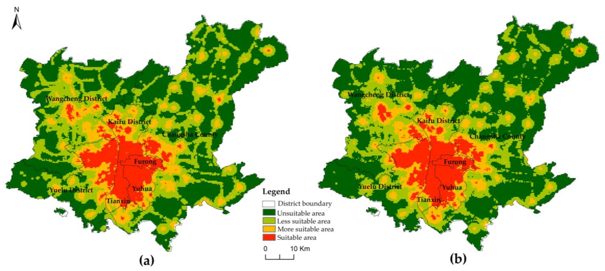
3.1. Spatial Distribution Characteristics of Land Development Suitability for Elderly Facilities

The spatial distribution characteristics can show the spatial difference and the non-equilibrium between regions in the suitability of land use for elderly care facilities. The evaluation scores and spatial distribution characteristics of the suitability of land development for elderly care facilities were obtained by the ArcGIS platform. In Changsha, the geographical distribution of land suitability for elderly facilities verified a pattern of “high in the middle and low in the surrounding region, with high-value clusters in the city center and distributed outward, and infrequent scattered clusters in the suburbs.” Due to its favorable environment, convenient transportation, obvious advantages in medical resources and high quality of economic development, the core area of Changsha shows the spatial distribution characteristics of high-value agglomeration. Furong District is highly suitable for the whole area. As the political and cultural center of Changsha in the early stage, resources and environment are at a high level. Gaotangling, Yujiapo, Dingzi Bay and Moon Island are sporadically distributed with the high-value areas of Xianglong, Xingsha, and Quantang in Changsha County, because the former is generally dependent on better medical facilities and transportation conditions, while the latter is closely connected with the municipal district. Low-value areas were most concentrated in Wangcheng District and Changsha County, with a small number distributed at the edges of the city-administered districts, such as Ladou River, Qingzhu Lake, and Shaping Street in the northern part of Kaifu District; Dato in the southern part of Tianxin District; the southeastern part of Yuhua District; and over half the southwestern part of Yuelu District. In comparison to other districts, Yuelu district has the highest proportion in low-value area due to its low development intensity, short construction period, and inadequate supporting facilities.

3.2. Comprehensive Evaluation Grade Analysis of Land Suitability for Elderly Facilities

As depicted in Figure 4, the GIS natural breakpoint approach was used to reclassify the evaluation results of the community home and institutional aged sites into four categories: inappropriate, less suitable, more suitable, and suitable.
(1)
Suitable area. The land use characteristics in this type of area are optimal for senior facilities. The index range of community home suitable area is 2.95 to 4.82, accounting for 9.99% of the study area; the index range of institutional suitable area is 2.73 to 4.42, accounting for 10.06%, and the distribution of the two is very similar, concentrated in the municipal district and distributed in a row, and clustered sporadically in the north and south direction of the suburbs and the township centers on the outskirts of the city.
(2)
More suitable area. Its construction and development conditions are second only to the suitable construction area, but certain indicators have disadvantages and the development is constrained to some extent. The community home range is 1.55–2.73, accounting for 13.76%; the institutional range is 1.63–2.73, accounting for 12.37%. Spatially, they are all concentrated around the municipal district, extending in the north-south direction, and clustered in a point-like manner in the townships of Changsha County and Wangcheng District.
(3)
Less suitable areas. There are more negative characteristics in this category, which hinders the total development of property for senior amenities. The range of the community house index is 0.92 to 1.78, representing 30.25%; the range of the institution index is 0.79 to 1.63, representing 26.7%. Overall, the distribution is comparable, with residential land use and transportation route direction accounting for the majority of the dispersion outside of the municipal area.
(4)
Unsuitable area. This category is spread in regions where all indicators are deficient, and it is nearly inappropriate for development and construction usage as land for senior care institutions. The range for community homes is between 0.28 and 0.92, accounting for 45.88% of the total area, whereas the range for institutions is between 0.11 and 0.79, accounting for 50.14%of the total area, indicating that the land requirements for institutional elderly facilities are higher and more stringent for all indicators.
The more suitable and suitable areas in the study area are mainly concentrated in the central part of the city, accounting for a smaller proportion, but both transportation conditions and medical facilities and other resources occupy a considerable advantage: Superior transportation conditions can save time costs for children visiting the elderly, and are also convenient for the elderly to travel, reducing the sense of isolation of the elderly; also, sound medical facilities are the primary factor in the selection of land for elderly facilities. More than half of the total is comprised of less suitable and unsuitable regions, which are primarily located in the city’s suburbs. We should expand road investment and medical facility building to establish the groundwork for conserving backup resources for land for senior care facilities.
The area ratio of different grades among administrative districts is shown in Table 5, Furong District is mainly suitable, and more suitable areas and the majority of suitable areas, which is the most suitable for the development of elderly care business; Tianxin District and Yuhua District are mainly suitable and more suitable areas, there are no unsuitable areas, and there are obvious advantages for the development of elderly care business. In Kaifu District, there are some unsuitable areas and a few unsuitable areas, and the advantage of the northern area is weak. Wangcheng District and Changsha County have more than half of the unsuitable and less suitable areas, and most of the areas in them are less suitable.

3.3. Suggestions

3.3.1. Optimization of Layout Suggestions

To further verify the matching degree between the suitability evaluation of land use for elderly facilities and elderly facilities, this research visualized the results of the overlay suitability evaluation of the current elderly facility points and constructed ideal Thiessen polygon with the current elderly facility points as the center, and the intersection of Thiessen polygon had the characteristics of maximum coverage and facility balance, i.e., fairness, as shown in Figure 5. It was observed that the fit between the current elderly facilities and the suitability evaluation results was high, and the regional differences and unevenness of spatial distribution were very significant. The Thiessen polygon of both models shows the characteristics of a small geometric area in the urban center and gradually increasing or even multiplying towards the periphery, which indicated that the demand for elderly care in the urban center can be well met, while the supply in the periphery was insufficient, and the single elderly care facility in the periphery radiates too large an area and serves people even across several towns, so the pressure on the elderly care facilities was huge and it is difficult to meet the demand for elderly care facilities of the elderly population in the urban periphery. It was difficult to meet the needs of the elderly population in the urban periphery, and it also reflects the unbalanced distribution of resources among towns.
Urban centers and suburbs, with a high density of elderly population and obvious advantages of resources within the city, should lay out community home care facilities in each street as much as possible, and their best location should be in the Thiessen polygon intersection as well as in the suitable construction area, such as Xingsha, Quan Tang, Mapoling, Dongan, Yuehu, Qingshui Tang, Xinhe, Guanshaling, Moon Island, Liuyang River, Xianglong, Pioneer, Yanghu, etc.; for institutions, suburbs can be laid out in the southeastern part of Lukou Town, the eastern part of Quan Tang and the junction of Huanghua Town in the suburbs, Xianglong, and the area of Moon Island. The distribution of the elderly population in the urban fringe towns is more scattered and less dense, plus the traffic and medical conditions are far less than those in the urban center, so the demand for community home care facilities is smaller, and it is more suitable to add large elderly institutions to meet the needs of a larger range of elderly people, such as the lack of elderly resources in the northeastern part of Changsha County, and the addition of Junction Town, Fulin Town, Qingshanpu Town, and Baisha Town can greatly alleviate the pressure of existing elderly institutions. Therefore, giving full play to the role of institutional senior care facility sites in distant suburbs is crucial to improving the senior care problem in suburban villages.

3.3.2. Exploring Strategies for Redeveloping the Stock of Land

This study explores the potential of urban stock land from the perspective of proposing an optimization technique for land usage in senior care. To obtain the appropriate urban construction area, the suitable area of suitability evaluation is extracted and superimposed with the urban construction area retrieved from the land use status map. The visualization of community home care facilities in Yuhua District and Tianxin District and the construction of the Thiessen polygon, combined with the stock of residential land in the first quarter of 2022 in Changsha City, as an alternative location for future supplementary or reserved land for elderly care facilities. Since most of the stock land in the Changsha urban area is concentrated in Yuhua District and Tianxin District, and there is a relative lack of pension facilities in the border areas of these two districts, there is a large area of Thiessen geometry and Theisen geometry, indicating that a pension facility must serve a larger area. Since the service range of community home pension facilities typically includes the street level, the new points should be picked as much as possible in areas with big Thiessen polygons. In the interim, the new points should be satisfied in the city’s acceptable building area and stock land, and alternative land locations for the new elderly care facilities should be provided, as depicted in Figure 6.

4. Conclusions and Discussion

4.1. Discussion

This paper takes Changsha urban area as the research object and evaluates the suitability of its land use for elderly facilities by using multi-source data such as POI data, OSM road network data and current land use data, and further discusses the layout strategy of land use for elderly facilities by interviewing the Elderly Section of Changsha Municipal Government, which can help alleviate the aging phenomenon in Changsha as well as provide reference for the planning of land use for elderly facilities in Changsha. The research results show that the suitable land for elderly care facilities in Changsha City is mainly concentrated in the central part of the city. The spatial distribution of elderly care facilities is uneven, and it is necessary to implement a stepped layout of elderly care facilities of different scales. For the source of land for elderly care facilities, the transformation of urban stock land can be emphatically considered. To ensure the effective supply of land for elderly care facilities, it is necessary to gradually strengthen institutional guarantees.
This study also has certain limitations. Due to the confidential nature of the data on the old population at the block level, the density of the elderly population can only be represented at the district level, so limiting the scope of the study and affecting its depth. In terms of evaluation factors, the selected buffer zone analysis approach is insufficiently unique and fails to account for the real route, which needs to be further optimized. Due to changes in the age composition, ethnic composition, and customs of the population, the special requirements for elderly care facilities and associated land use environment, such as self-care and non-self-care, and disregard for the preferences of the elderly, vary. The evaluation of the suitability of aged care land for various age groups, customs, and habits can be further refined and maximized through the use of extensive questionnaires and future research. In addition, due to data restrictions, this research only conducts empirical analysis from the standpoint of residential land stock, although the actual area that can be utilized for senior care is far more. Future studies should include field considerations for crucial locations, and data sources should be broadened to ensure quality. The conclusions of the analysis are more objective and rational.

4.2. Conclusions

(1)
The spatial distribution characteristics of “strong in the middle and weak in the surroundings” are shown in the evaluation of the suitability of land for elderly facilities. The suitable areas are mainly concentrated in the central part of the city, while the less suitable and unsuitable areas are mainly concentrated in the suburbs and account for more than half of the area. In order to meet the expanding demand for land for elderly facilities, we should also continuously improve the construction of medical and transportation infrastructure in the suburbs to improve the suitability of land for elderly facilities and reserve backup resources.
(2)
The Thiessen model centered on senior care facilities shows that the spatial distribution of senior care facilities in different modes varies significantly, with community home senior care facilities concentrated in urban centers and institutional senior care facilities spread throughout urban areas, but both have in common that the number of facilities in central cities is significantly higher than that in suburban areas, and the allocation of senior care facilities in urban and rural areas is less balanced.
(3)
To optimize the spatial layout of land for elderly facilities, the following strategies are proposed. ① Enhance the hierarchical structure of senior care institutions in accordance with Changsha Civil Affairs Bureau’s design in order to establish a three-tiered senior care service structure of “district-county-community-street (township)” that connects urban and rural areas effectively. For different types of land proposed for the elderly: the land for the elderly under the jurisdiction of the city due to its high suitability and dense elderly population, to the streets as a unit, with an emphasis on the layout of community home care facilities to provide basic protection for the elderly. In the suburban areas, the elderly population is relatively dense, the traffic and medical facilities are complete, and the overall suitability is good, so the investment in community home and institutional elderly care facilities should be increased; in the peripheral areas of the city, more medium- and high-end elderly institutions can be built; in the distant suburbs, combined with the characteristics of its extensive and sparse population, large elderly institutions should be set up around the township centers, the more suitable areas with developed traffic networks and better medical facilities to expand the scope of services should be expanded. ② Based on the evaluation results of suitability of senior citizen land constructed in this paper, and from the perspective of urban stock land, we actively explore the potential senior citizen land, and take Tianxin District of Yuhua District as a case study, and propose alternative sites for new senior citizen facilities to effectively relieve the pressure on community senior citizens.

Author Contributions

Conceptualization, J.Y. and Z.L.; methodology, J.Y.; software, Z.L.; validation, J.Y., Z.L., X.T. and Y.S.; formal analysis, J.Y.; investigation, Z.L.; resources, J.Y.; data curation, Z.L., X.T. and Y.S.; writing—original draft preparation, J.Y.; writing—review and editing, Z.L.; visualization, Z.L.; supervision, J.Y.; project administration, J.Y.; funding acquisition, Z.L. All authors have read and agreed to the published version of the manuscript.

Funding

This work was supported by Research Project of Hunan Provincial Department of Natural Resources “Research on the Optimization of Land Use for Elderly Service Facilities in Urban Spaces under the Background of Population Aging” (2021G03).

Institutional Review Board Statement

Not applicable.

Informed Consent Statement

Not applicable.

Data Availability Statement

The data presented in this study are available on request from the corresponding author.

Acknowledgments

We sincerely thank Hunan Provincial Department of Natural Resources for their support of this research.

Conflicts of Interest

The authors declare no conflict of interest.

References

  1. Liao, Y.; Lei, A.; Huang, Q.; Zhou, T. Research on pension land policy. China Land 2013, 3, 8–12. [Google Scholar]
  2. Chen, X. Current situation and regional differences of disability in the elderly population in China. Chin. J. Gerontol. 2022, 42, 1197–1201. [Google Scholar]
  3. Feng, J.; Hong, G.; Qian, W.; Hu, R.; Shi, G. Aging in China: An International and Domestic Comparative Study. Sustainability 2020, 12, 5086. [Google Scholar] [CrossRef]
  4. Guo, Y.; Zhou, Y.; Han, Y. Spatio-temporal evolution of china’s rural population aging and rural revitalization countermeasures. Geogr. Res. 2019, 38, 667–683. [Google Scholar]
  5. Central Committee of the Communist Party of China State Council. Outline of the Tenth Five-Year Plan for the Development of China’s Aging Career (2001–2005). Available online: http://www.gov.cn/zhengce/content/2016-09/23/content_5111148.htm?from=timeline&isappinstalled=0 (accessed on 28 December 2022). (In Chinese)
  6. Central Committee of the Communist Party of China State Counci. National Plan for the Development of the Aged Cause and the Elderly Care Service System during the “Fourteenth Five Year Plan”. Available online: https://www.mca.gov.cn/article/xw/mtbd/202202/20220200039833.shtml (accessed on 28 December 2022). (In Chinese)
  7. Dizon, L.; Wiles, J.; Peiris-John, R. What Is Meaningful Participation for Older People? An Analysis of Aging Policies. Gerontologist 2020, 60, 396–405. [Google Scholar] [CrossRef]
  8. Haines Terry Robinson Andrew, L.; Palmer Andrew, J. A new model of care and in-house general practitioners for residential aged care facilities. Med. J. Aust. 2021, 215, 44. [Google Scholar] [CrossRef]
  9. Gan, D. Study on the Dilemma and Suggestions of Rural Pension Model in China. World Sci. Res. J. 2022, 8, 97–101. [Google Scholar]
  10. Xia, M.; Wu, B.; Li, T. Analysis on the Development Status and Prospects of the Intelligent Pension Model in Tianjin. Humanit. Soc. Sci. 2019, 7, 34–48. [Google Scholar] [CrossRef] [Green Version]
  11. Shuang, G.; Lu, Y.; Tao, P. Research Progress on the Model of Combining Medical and Elderly Care in Foreign Countries. J. Nurs. 2021, 36, 17–20. [Google Scholar]
  12. Yi, H.; Xiaoguang, T. Analysis on the current situation of aging population in Chinese. Chin. J. Gerontol. 2012, 32, 4853–4855. [Google Scholar]
  13. Peng, X.; Hu, Z. Aging of Chinese population from the perspective of public policy. Chin. Soc. Sci. 2011, 32, 106–124. [Google Scholar]
  14. Hu, A.; Liu, S.; Ma, Z. Population Aging, Population Growth and Economic Growth: Empirical Evidence from China’s Interprovincial Panel Data. Popul. Res. 2012, 36, 14–26. [Google Scholar]
  15. Gao, X.; Wu, D.; Xu, Z. A Review of Aging Geography in China and the Construction of a Research Framework. Prog. Geogr. 2015, 34, 1480–1494. [Google Scholar]
  16. Wang, H.; Liu, J.; Fang, Y. Multi-scale spatio-temporal evolution and influencing factors of population aging in Northeast China. Reg. Res. Dev. 2021, 40, 147–153. [Google Scholar]
  17. Jiang, B.; Huang, B.; Zeng, B. Demand and suitability evaluation of “six-in-one” senior living circle facilities: Taking Gulou District of Nanjing as an example. Sci. Technol. Eng. 2022, 22, 5860–5870. [Google Scholar]
  18. Zhang, S.; Liu, H.; Wang, H. Research on the Equilibrium of Institutional Pension Facilities in Tianjin Downtown. Mod. Urban Res. 2022, 1, 38–44. [Google Scholar]
  19. Xiao, C.; Zhang, Y.; Lei, X.; Luo, J.; Zhao, G. Research on the Needs and Influencing Factors of Embedded Elderly Care Services in the Elderly Community. J. Nurs. 2022, 37, 91–93. [Google Scholar]
  20. Peng, J.; Xin, L.; Yang, H. Research on Planning and Layout of Elderly Service Facilities Based on Supply and Demand Matching. J. Geo-Inf. Sci. 2022, 24, 1349–1362. [Google Scholar]
  21. Ling, Q. Research on the Improvement and Implementation of Land Use Policy for Old-age Service Facilities in China. Contemp. Econ. Manag. 2016, 38, 52–55. [Google Scholar]
  22. Lu, J.; Guo, F.; Chen, J. Rural Pension System Design in the New Era: Historical Context, Practical Dilemma and Development Path. J. China Agric. Univ. 2021, 38, 113–122. [Google Scholar]
  23. Xuerui, Q. On the supply optimization and supervision of pension land. China Land Resour. Econ. 2019, 32, 58–62. [Google Scholar]
  24. Mu, H. From “Pyramid” to “Olive Type”: The Design and Optimization of the New Three-Pillar Old-age Security System. Soc. Sci. 2022, 1, 82–93. [Google Scholar] [CrossRef]
  25. Li, B.; Ji, Y.; Zhao, X.; Qiu, W. Research on spatial accessibility of elderly care institutions in Xuzhou based on GIS. J. Suzhou Univ. Sci. Technol. 2021, 38, 65–69+75. [Google Scholar]
  26. Yong, T. Study on the key factors and characteristics of the future elderly care model. Basic Clin. Pharmacol. Toxicol. 2020, 127, 291. [Google Scholar]
  27. Amini-Behbahani, P.; Meng, L.; Gu, N. Walking distances from services and destinations for residential aged-care centres in Australian cities. J. Transp. Geogr. 2020, 85, 102707. [Google Scholar] [CrossRef]
  28. Hao, Z. Spatial Matching and Policy-Planning Evaluation of Urban Elderly Care Facilities Based on Multi-Agent Simulation: Evidence from Shanghai, China. Sustainability 2022, 14, 16183. [Google Scholar]
  29. Rahouti, A.; Lovreglio, R.; Nilsson, D.; Kuligowski, E.; Jackson, P.; Rothas, F. Investigating Evacuation Behaviour in Retirement Facilities: Case Studies from New Zealand. Fire Technol. 2021, 57, 1015–1039. [Google Scholar] [CrossRef]
  30. Wang, H.; Liu, H.; Zhang, S. Research on Spatial Layout Evaluation of Institutional Elderly Care Facilities in Downtown Tianjin. Urban Hous. 2020, 27, 123–127. [Google Scholar]
  31. Crooks, V.A.; Finlay, J.; Widener, M. Introduction to the special section: The changing geographies of aging. Can. Geogr. 2022, 66, 48–51. [Google Scholar] [CrossRef]
  32. Xin, Y. How China Responds to the Challenge of Population Aging. Natl. Gov. 2014, 21, 13–18. [Google Scholar]
  33. Hunan Provincial Bureau of Statistics. Bulletin of the Seventh National Census of Hunan Province (No. 4). Available online: http://tjj.hunan.gov.cn/hntj/wzzl/hnsdqcqgrkpc/qrptzgg/202105/t20210519_19054787.html (accessed on 30 December 2022).
  34. Hunan Provincial Bureau of Statistics. Hunan Statistical Yearbook (1998–2018); China Statistical Publishing House: Beijing, China, 2018. [Google Scholar]
  35. Li, S.; Song, Q.; Yuan, S. Research on Site selection of elderly care real estate projects based on GIS: A case study of Tianjin. J. Tianjin Univ. 2017, 19, 204–209. [Google Scholar]
  36. Zhu, C.; Li, Y.; Sun, X.; Xu, J.; Fu, Z. Urban public bicycle demand forecast considering land use. J. South China Univ. Technol. 2022, 50, 9–20+37. [Google Scholar]
  37. Zhou, C.; Zhang, D.; He, X. Transportation Accessibility Evaluation of Educational Institutions Conducting Field Environmental Education Activities in Ecological Protection Areas: A Case Study of Zhuhai City. Sustainability 2021, 13, 9392. [Google Scholar] [CrossRef]
  38. Hu, M.; Yong, X.; Li, X.; Zhou, X. Spatial layout optimization of rural residential areas under the guidance of urban-rural integration: A case study of Tongshan District, Xuzhou City. Geogr. Geo-Inf. Sci. 2022, 5, 104–110. [Google Scholar]
Figure 1. Research ideas.
Sustainability 15 02034 g001
Figure 2. The location of seven districts of Changsha, China, Schematic of elevation.
Sustainability 15 02034 g002
Figure 3. Population density map of Changsha district-level elderly over 65 years old (including 65 years old).
Sustainability 15 02034 g003
Figure 4. Evaluation of land suitability of community home and institutional endowment facilities. (a) Community Home; (b) Institution.
Sustainability 15 02034 g004
Figure 5. Optimization of land use layout for elderly care facilities.
Sustainability 15 02034 g005
Figure 6. Additional sites for new community senior facilities. (The Chinese characters in the picture come from the Autonavi map and show the names of the city’s main roads and green parks).
Sustainability 15 02034 g006
Table 1. POI data volume.
Data SourceClassificationQuantity
POI dataPark218
Factory1555
Residence4262
Public transport stations4244
Subway Stations135
Medical and Health Facilities601
Senior Care Facilities200
Table 2. Results of evaluation index weights for suitability of land development for institutional elderly facilities.
Target LayerGuideline LayerIndicator LayerExpert Scoring Method WeightsAHP WeightsFinal Weights
land development for institutional elderly facilitiesEnvironmental Factor B1Park Distance C10.090.120.11
Water system lake distance C20.070.050.06
Factory distance from C30.060.030.05
Rail distance C40.060.020.04
Residential land use distance C50.090.090.09
Supporting facilities factor B2Bus stop distance C60.070.10.08
Subway Station Distance C70.060.080.07
Distance of traffic road C80.060.040.05
Living road network density C90.070.060.07
Hospital distance C100.110.280.20
Socio-economic factors B3Population density of the elderly aged 65 and over C110.090.020.05
GDP per capita C120.070.040.06
Disposable income per capita C130.100.060.08
Table 3. Results of evaluation index weights for the suitability of land development of community home care facilities.
Target LayerGuideline LayerIndicator LayerExpert Scoring Method WeightsAHP WeightsFinal Weights
land development for community home care facilitiesEnvironmental Factor B1Water system lake distance C10.110.070.09
Park Distance C20.160.130.15
Supporting facilities factor B2Bus stop distance C30.080.130.11
Subway Station Distance C40.070.070.07
Traffic road distance C50.050.030.04
Density of living road network C60.080.080.08
Hospital distance from C70.130.290.21
Socio-economic factors B3Population density of the elderly aged 65 and above C80.120.070.09
GDP per capita C90.080.030.05
Disposable income per capita C100.100.110.10
Table 4. Buffer distance setting and assignment results.
IndicatorsBuffer Setting Distance (m)Corresponding Score
Park Distance500; 1000; 1500; 2000; 25005; 4; 3; 2; 1
Water system lake distance300; 500; 800; 1000; 12005; 4; 3; 2; 1
Factory Distance500; 800; >800−2; −1; 0
Rail distance500; 800; >800−2; −1; 0
Residential land distance500; 1000; 1500; 2000; 30005; 4; 3; 2; 1
Bus stop distance200; 400; 600; 800; 10005; 4; 3; 2; 1
Subway Station Distance200; 400; 600; 800; 10005; 4; 3; 2; 1
Distance from traffic-oriented roads100; 200; 300; 4000; 500−1; 4; 3; 2; 1
Hospital Distance500; 1000; 1500; 2000; 30005; 4; 3; 2; 1
Table 5. Distribution of area share of suitability class.
Type DistrictcFurong DistrictKaifu DistrictTianxin DistrictYuhua DistrictYuelu DistrictChangsha CountyWangcheng District
County Grade
Land for institutional elderly facilitiesUnsuitable area0.00%7.89%0.00%0.00%40.46%60.56%49.70%
Less suitable area0.00%29.76%14.13%5.08%23.51%27.97%34.25%
More suitable area9.16%29.39%18.62%23.73%15.25%9.20%12.67%
Suitable area90.84%32.96%67.26%71.19%20.78%2.26%3.38%
Land for community home care facilitiesUnsuitable area0.00%7.83%0.00%0.00%38.65%56.16%46.02%
Less suitable area0.00%27.76%6.26%5.28%26.13%31.50%38.02%
More suitable area6.74%32.39%24.88%22.80%16.80%10.67%13.72%
Suitable area93.26%32.02%68.86%71.92%18.42%1.67%2.25%
Disclaimer/Publisher’s Note: The statements, opinions and data contained in all publications are solely those of the individual author(s) and contributor(s) and not of MDPI and/or the editor(s). MDPI and/or the editor(s) disclaim responsibility for any injury to people or property resulting from any ideas, methods, instructions or products referred to in the content.

