Article

River Sand and Gravel Mining Monitoring Using Remote Sensing and UAVs

by
Daniel Constantin Diaconu
1,2,
Paschalis D. Koutalakis
3,
Georgios T. Gkiatas
3,
Gabriel Vasile Dascalu
4 and
George N. Zaimes
3,5,*
1
Research Center for Integrated Analysis and Territorial Management, University of Bucharest, 4-12 Regina Elisabeta Avenue, 030018 Bucharest, Romania
2
Buzău-Ialomița Water Administration, 20 Bis Bucegi Street, 120208 Buzău, Romania
3
Geomorphology, Edaphology and Riparian Areas Laboratory (GERi Lab), Department of Forestry and Natural Environment Science, International Hellenic University, University Campus in Drama, 66100 Drama, Greece
4
Simion Mehedinți “Nature and Sustainable Development” Doctoral School, University of Bucharest, 061071 Bucharest, Romania
5
Unesco Chair Con-Ε-Ect, 66100 Drama, Greece
*
Author to whom correspondence should be addressed.
Sustainability 2023, 15(3), 1944; https://doi.org/10.3390/su15031944
Submission received: 12 December 2022 / Revised: 16 January 2023 / Accepted: 17 January 2023 / Published: 19 January 2023
(This article belongs to the Section Sustainable Water Management)

Abstract

:
The development of methodologies for analyzing the evolution and pressures exerted on the river channel network is one of the main concerns of researchers today. The assessment of natural or artificial changes of river channels and beds plays an important role in environmental protection, but also in the implementation of integrated water resource management plans. Given the episodic and dynamic nature of river bank and bed erosion, along with the difficulty of reaching certain reaches, a methodological approach that uses aerial imagery, initially from satellite sources and afterwards from unmanned aerial vehicles, is proposed. This approach was utilized in a perennial river in Romania but also in an ephemeral torrent channel in Greece, in order to test the prevalent types of hydrographic network in the Mediterranean and Black Sea region. The methodology used was able to identify the location and the volume of the bed material extracted and the time frame in which it occurred. These encouraging results showcase an accurate but also relevantly low-cost monitoring method for illegal anthropogenic activities that can be easily adopted by the responsible authorities. The adoption of the method will contribute to the more efficient monitoring of river protection, by accurately and timely identifying areas of illegal river bed extraction that will enable authorities to enforce European Union and national legislation.

Graphical Abstract

1. Introduction

Sand and gravel are the most mined materials on Earth and their extraction rates are exceeding natural sand and gravel replenishment rates [1]. In Romania and Greece, as in all European member countries, the exploitation of sand and gravel from the river beds is carried out based on authorizations issued by the specific river administrators [2]. When issued, several rules are taken into account, such as: ensuring the conservation of river equilibrium and its natural environment; the stability of the longitudinal and transversal profile of the riverbed and its slope; avoiding damage of the hydrotechnical constructions; and the mitigating of water pollution [3]. In Romania, the Romanian Waters and the National Agency for Mineral Resources have joint responsibility for permitting the exploitation of sand and gravel from the beds of minor rivers, while the latter has sole responsibility for administering mineral waters [4]. In Greece, the decentralized administration of each region (depends on the location of the sand extraction) is the responsible authority. In accordance with Articles 967 and 968 of the Greek Civil Code, rivers and streams belong to the Greek State and river sand/gravel is considered a public resource that can be available for public and private works after a fixed price, specified by the PSA [5]. Unfortunately, in many cases, operators do not follow the legal procedures and extract river sand/gravel without the necessary mining and environmental license.
The increased worldwide demand for sand and gravel has driven to illegal mining, causing environmental degradation, such as river pollution, accelerated erosion, and lowering of the water level [6]. The negative impacts on the channel bed, can be propagated upstream and downstream for many kilometers. This occurs when the sand and gravel mining is carried out improperly and unregulated, and alters the natural river equilibrium base level. Altering the river equilibrium and base level induces changes in the channel bed and banks, typically causing their significant degradation (e.g., channel incision, soil loss, increased water turbidity, sedimentation of artificial lakes, habitat disturbance, alteration of riparian zones) [7,8,9].
The 27 member states of the European Union agreed on a Raw Materials Initiative, which was published by the European Commission in November 2008 [10]. There are multiple impacts that mining has on the environment, socially and on the local economy of each member state [11]. For this reason, a strong policy framework for sustainable resource management is required to guarantee the materials and energy supply of the EU economy, but also to safeguard the natural resources basis for future generation [12]. The United Nations Environment Program (UNEP) published a report on sand and sustainability, recommending regulation, monitoring, and stronger governance as solutions to the issues surrounding the excessive exploitation and trade of sand [13]. While many countries have banned sand mining from lakeshores, river floodplains, or beaches, the legislation is some cases is insufficient or in other cases not enforced adequately due to the absence of effective monitoring [8]. If properly managed and supervised by responsible authorities, river sand and gravel mining can be a useful tool in flood control and bank stabilization [14]. Collaborative spatial databases and maps are powerful tools to collect, share, and publish information on social conflicts of environmental issues as is the Global Atlas of Environmental Justice (EJAtlas) produced by the Environmental Justice Organizations, Liabilities, and Trade (EJOLT) [15,16].
Most studies in the Black Sea Basin, and specifically in Romania, are focused on monitoring coastal sand and gravel mining [17,18,19,20]. Mining sites are recorded in a database in order to be able to get a legal permission from the responsible Romanian authorities; still, sand and gravel mining has put significant pressure on Romanian rivers and their alluvial plains [21,22,23]. In Greece, there are many active and abandoned mines all around the country since mining started in the Bronze Age [24]. So, most studies are focused on mines of important minerals and deposits [25,26] e.g., mining in the Ptolemais Lignite mines [27] or Amyntaio open pit coal mine [28]. In addition, there are also studies focused on coastal environments, e.g., beach sand extraction [29], but also on environmental monitoring, analysis, and assessment focused on channel and floodplains [30,31].
There are different methods to monitoring erosion/deposition, whose accuracy varies depending on the technology utilized [32,33]. The time interval in which the measurements are repeated is an important factor in determining the temporal and spatial evolution of the phenomenon. Images captured from specialized satellites, as well as from unmanned aerial vehicles (UAVs), are more frequently being used worldwide in remote sensing applications to monitor fluvial geomorphological processes [34,35]. The limitations of these methods are due to the cost of image acquisition, the unclear images of the river channel due to weather conditions or vegetation cover of the studied sites, and identifying the optimal type of UAVs that should be used [36,37]. By performing repeated UAVs flights along the same river reaches, the changes that take place along the banks and beds can be determined with the help of the captured images, that also permit the quantitative determination of the alluvium deposited or eroded in the river [38,39]. Currently, UAVs are widely used in various applications as an alternative or in combination with satellite systems for monitoring and modelling the Earth’s surface [40,41,42,43]. The main disadvantages of UAVs are the battery life limitations and the difficulty of flying during extreme weather conditions (e.g., wind, rain, or fog) [44]. At the same time, UAVs offer significant advantages in terms of time, cost, data acquisition, and image resolution, compared to terrestrial photogrammetry and satellite remote sensing systems [45].
This study highlights the usefulness of small UAVs in identifying illegal gravel and sand mining sites in river beds (Romania), but also in smaller torrents (Greece). The proposed methodology helps to identify when the mining occurs in a river/torrent bed, but also estimate its dimensions. The high resolution of the images, and the ability of repeated flying over a river or torrent/stream reach, allows the frequent and detailed monitoring of large areas at a relatively low cost. This methodology can help the authorities responsible to quickly and easily identify illegal gravel and sand mining sites in the river/stream/torrent. This should help better regulate the problem of illegal mining and thus help mitigate serious environmental damage to riverine/stream/torrent ecosystems.

2. Materials and Methods

2.1. The Buzau River (Romania)

The study area of Buzău River is located between the sub-Carpathian hills and the Buzău mountain area (Figure 1). The specific area is the Romanian pilot area in the Protect-Streams-4-Sea Project. The project “Protecting streams for a clean Black Sea by reducing sediment and litter pollution with joint innovative monitoring and control tools and nature-based practices (BSB963)” with the acronym “Protect-Streams-4-Sea”, that aims at the protection of the Black Sea from litter and sedimentation using innovative monitoring and control tools, such as fingerprint method, drone mapping, etc. [46]. The altitude of Buzău Basin is between 225 m and 1638 m. The Buzău Mountains consist of flysch deposits, arranged in two distinct strips in terms of age, petrographic nature, and tectonic mobility. The north-western part of the Siriu Massif was developed on the internal Cretaceous flysch, consisting of sandstone shale deposits with massive intercalations of sandstones [47]. The eastern part corresponds to the external Cretaceous and Paleogene age flysch, being composed of alternations of sand-stones, clay shales, menilites and disodiles and includes the Siriu, Penteleu and Podu Calului Mountains. The curvature of the sub-Carpathians is distinguished by the most complex geological structure in the whole sub-Carpathian ensemble. Its Neozoic sedimentary superstructure consists of sandstones, marls, clays, conglomerates, and limestones. It is an area where the alluvium generated from the mountain area is deposited especially in the small depressions characterized by the low slopes of the river.
The average precipitation recorded is 575 mm/year at Pătârlagele and 850 mm/year at Siriu. The average river flow of the Buzău River in the studied reach is 23.4 m3/s, with the maximum being 280 m3/s. The hydrologic regime is characterized by 1–2, maximum 3, flood events every year [48]. The analytical relationship between river flow (m3/s) and alluvial deposited material (kg/s) is linear represented by the following equation (Equation (1)):
y = a + bx,
where a and b are the parameters to be determined to satisfy the following condition (Equation (2)):
Sample   Variance = y i a bx i 2 ,
This is how the depiction of the final equation, after incorporating the parameter of Buzău Basin (Equation (3)):
Water Flow = 1.1638 × Alluvial Material + 2.7067
The correlation coefficient was r2 = 0.9185.
Given the land use, geological, and climatic characteristics of the study area, it is characterized by an accelerated instability of the river banks and bed. Any alteration along the river bed generates imbalances in the stability of the river banks. This translates into monitoring the current conditions and recommending implementation measures to protect and conserve it, is a necessity.

2.2. The Kallifitos Torrent (Greece)

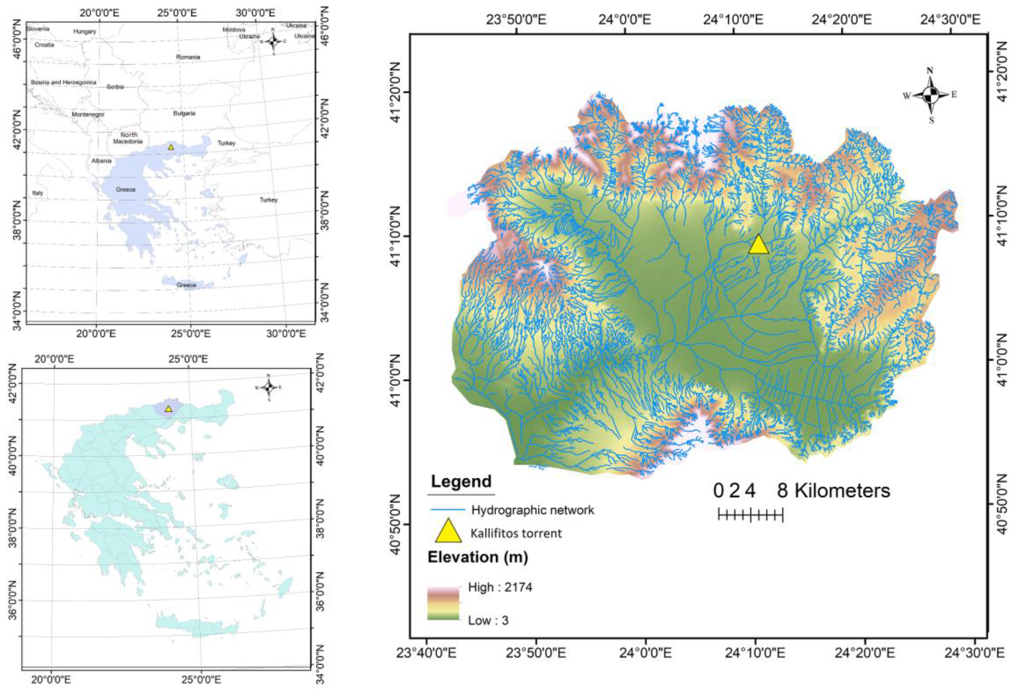
The Kallifitos torrent, located at the suburbs of Drama City in Greece (Figure 2), is a typical intermittent Greek torrent that has flash flood risk potential after heavy rainfalls [49]. The specific area is part of the Greek pilot area in the Protect-Streams-4-Sea Project. The flow can change in hours from no flow to a flow with great rapidity and carrying large amounts of water, sediments, and debris [50]. Its headwaters start at Falakro Mountain, continuing its flow nearby the Kallifitos village while it crosses through chutes under the city of Drama (Kallifitos watershed 115 km2) and finally discharges to Agia Barbara stream; a tributary of Aggitis River [51]. So, the Kallifitos torrent belongs to the greater Aggitis River Basin [52]. The area is cultivated for cereals such as wheat and barley, and as you move further downstream with maize and cotton [53]. The lowlands of the studied torrent have a variety in the bed width, the channel slope, the bank height, and slopes, with a meandering pattern and several anthropogenic interventions as it flows through the city of Drama [54]. The location of the specific studied reach is at the east entrance of Drama city, where there is also an Irish bridge (length: 45 m and width: 8 m) with 30 culverts of concrete pipes (diameter: 0.80 m and width: 8 m) [55]. The studied torrent reach is of high importance due to its proximity to Drama city, the fact that it causes frequent flooding and damages to the road network and the Irish bridge and disrupts the city’s transportation. The torrent has a diversity of fluvio-geomorphologic changes on its channel and bed shape with large amounts of sediment transported, deposited, and eroded during and after heavy rainfalls.

2.3. The Collected Data

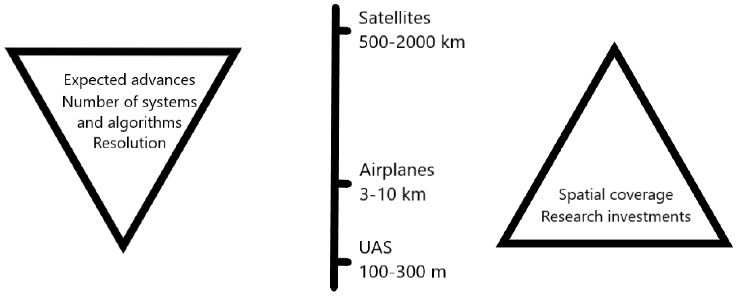
The study was based on data collected by UAVs and satellites. In order to validate the results, physical measurements were also carried out in the field. The term “Unmanned Aircraft System (UAS)” represents the entire category of aircraft without a pilot on-board; this includes UAVs (Figure 3).
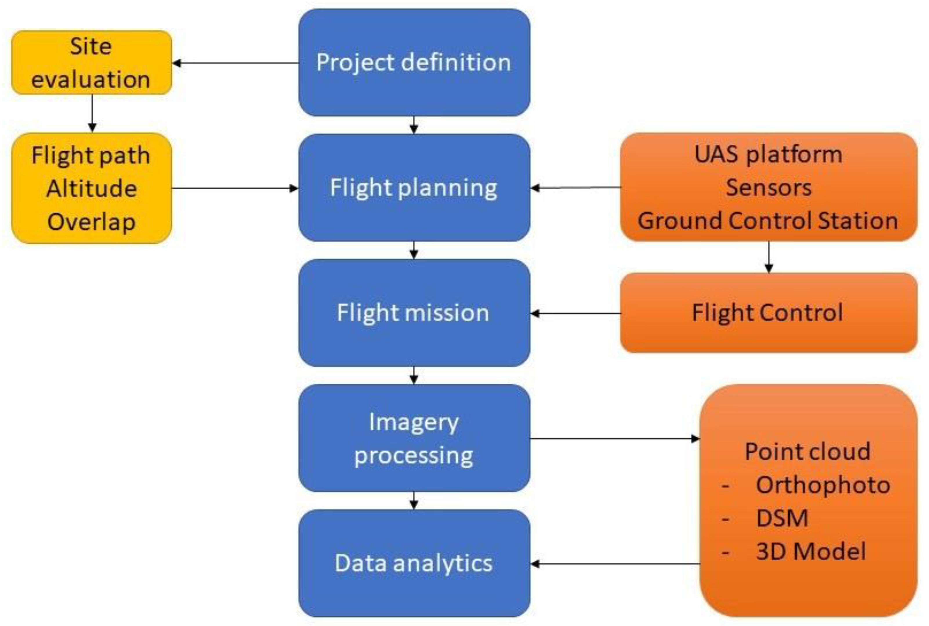
The main components of a UAV are the aerial platform (including airframe), the navigation system, the power system, and the payload [56]. There is a ground control station (GCS), which allows the human control from a remote emplacement [57]. UAS models differ in size and design and in included components depending on their intended applications [58,59]. UAVs can fly autonomously or be manually controlled remotely by a pilot. In both cases, the ground control station (tablet, laptop, remote controller, etc.) is a critical component of the system [60]. The data link that allows communication between the aircraft and the ground control station is the third essential element of a generic UAS. The steps of this research are presented in a flowchart (Figure 4).
During this study, the aerial recording for the Romania site was carried out with a DJI Mavic Mini 2 drone. The drone weighs less than 250 g and does not require a user-specific pilot license in Romania based on European Union Regulations [61]. The legislation requires registering the aircraft to the Romanian Civil Aviation Authority (RCAA) and attaching the registration number on the body of the drone. The drone-attached GPS system used is GPS/GLONASS. The maximum operating range of the drone is 10 km, although in practice it varies based on the GPS signal. The most important advantage of using this drone for aerial recording is the 4K quality video recording while it captures images of a resolution 4000 × 3000 pixels. The flight was done in 26 and 27 March of 2022 by collecting 220 images. The elevation in both flights was at 100 m at a polygon flight plan over the area. The area that covered was 0.320 square kilometers and the GSD was 1.15 cm. In the flights the front and side overlap were 85%. The method followed in this research is the comparison of consecutive images visually in order to spot locations of excavated material. The capture of the extracted material enabled us to capture the excavated material at the riverbanks.
The DJI Mavic 2 Pro was used to perform the airborne survey of the Greek studied reach. The particular drone is a quadcopter with a flight range of 31 min, weighting 734 gr, can capture images of 12 MP (4056 × 3040 pixels resolution) and can be interfolded for easy transportation [62]. It requires a pilot license and the registration to the Hellenic Civil Aviation Authority (HCAA) of both the pilot and the aircraft [63]. The monitoring of Kallifitos torrent included flights through the different periods to capture the conditions before and after rainfall events or anthropogenic work (e.g., sand extraction by heavy vehicle excavators). Specifically, two different flight missions were conducted to compare the outputs and monitor the fluvio-geomorphologic changes. These two flights were identical following the same flight plan and take off point (this area is frequently monitored for the needs of the funded project). The elevation in both flights was at 50 m and following the polygon mission flight plan. In the first flight on 24 August 2022 we collected 140 images. The area that covered was 0.027 square kilometers and the GSD was 1.15 cm. At the second flight on 23 October 2022 we collected 145 images. The area that covered was 0.028 square kilometers and the GSD was 1.13 cm. In both flights the front and side overlap were 90% with more than 5 images/pixel. Only the boundaries of the orthomosaic were represented by 1–2 images (as expected). This was an important advantage for the Greek site as it enabled us to compare these two datasets (that have similar format and information) and calculated the extracted material from the torrent bed. The first one was on (a) 24 August 2022 and the second one was in (b) 23 October 2022. In both flights collected more than 145 pictures from the UAV. In addition, the GPS/GNSS (Global Position System/Global Navigation Satellite System) RUIDE PULSAR R6P (Guangzhou, China) was used to record the real coordinates (in WGS 84). The UAV-based images were processed in the Pix4D software (Pix4D SA, Prilly, Switzerland) to produce the orthomosaics and digital surface models (DSMs) of the study reach [64]. The photogrammetric products, specifically the DSMs, were calibrated based on the field topographic measurements using the GPS/GNSS tool at the same level of reference in order to minimize the error [54,65,66,67,68]. The volumetric change (digital elevation model of differences—DoD) is calculated from the difference in the surface elevations from the digital surface models (DSMs) derived from the UAV-based surveys [69].
Additionally, we searched in the database of the Planet Scope in order to find images to prove the extraction date. The PlanetScope satellite images (initial resolution of 1 pixel = 3.00 m) that were utilized, originated from the Planet Explorer platform owned by Planet Labs PBC. The specific products are commercial with 50 cm resolution but we used the free sample images of low resolution. It has a daily frequency collection [70,71], and was provided by the legal distributor in Romania, as datasets for academic/research use. The timeframe of interest for this study was initially established, based on which satellite images without cloud cover were selected. The Planet Explorer platform has over 180 PlanetScope micro-satellites capable of collecting daily images, over the entire surface of the study area as well as at a distance of 50 km from the shoreline. All satellites (Dove) have sensors capable of collecting 4 RGB + NIR spectral bands, and the latest generations of satellites (DOVE-R and SuperDove) can collect up to 8 spectral bands (Coastal Blue 431–452 nm, Blue: 465–515 nm, Green I: 513–549 nm, Green: 547–583 nm, Yellow: 600–620 nm, Red: 650–680 nm, Red Edge: 697–713 nm, NIR: 845–885 nm) [72]. High resolution datasets with a resolution of 0.75 m using the constellation of 8 Skysat satellites with RGB + NIR spectral resolution were also provided. The images used have been downloaded in 29 March 2022.

3. Results

3.1. The Buzau River (Romania)

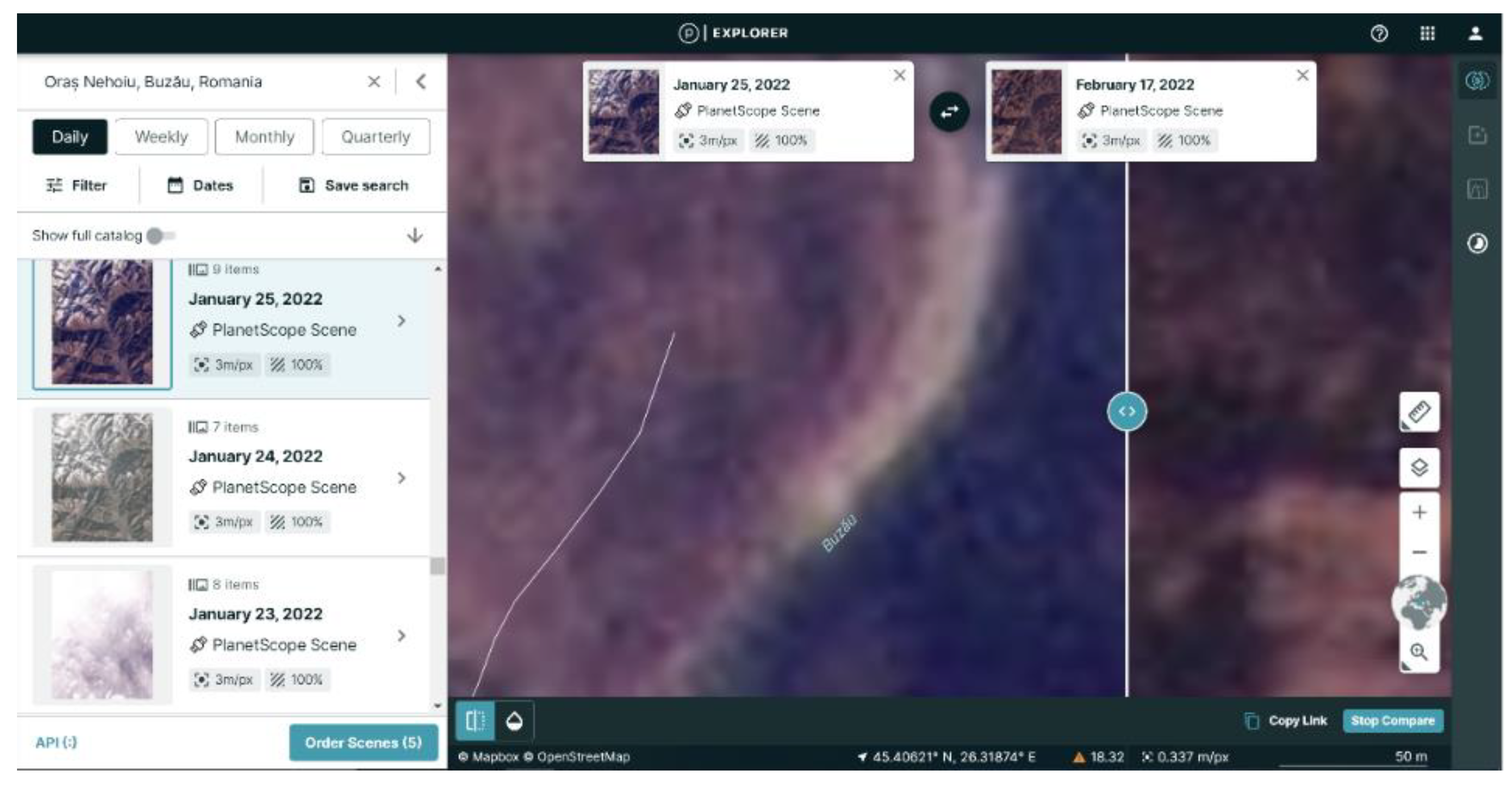
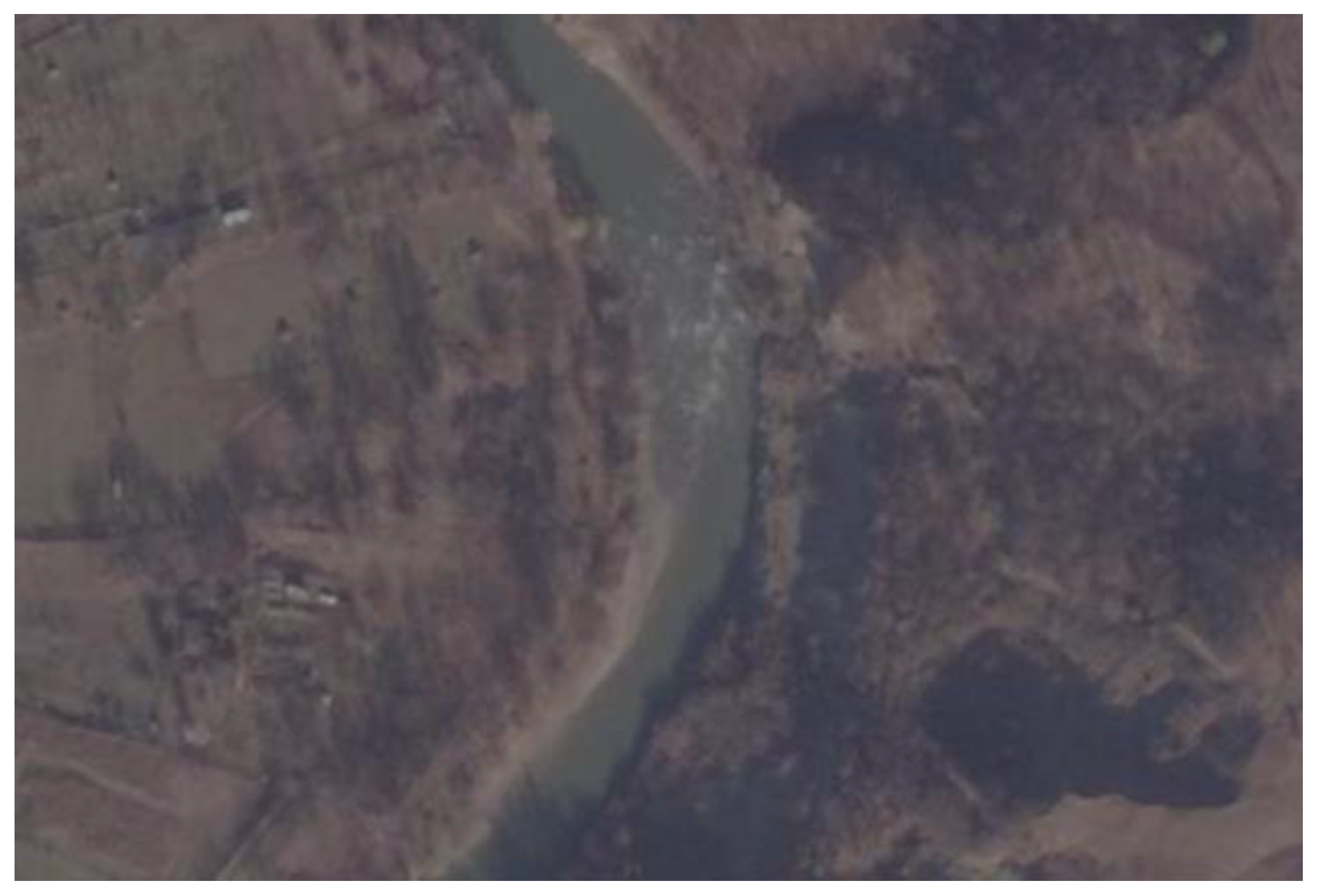
During a survey along the Buzău river valley, in March 2022, a series of mining locations of bed material from the major river bed were observed (Figure 5). The time of the bed changes (mining) was determined by the PlanetScope satellite images. The approximate time interval was 5 to 17 February 2022, based on the subsequent analysis. The exact determination of the locations was influenced by the quality of the available satellite data (the area investigated should not be shaded by clouds or have alterations in the resolution when merging images) (Figure 6).
In order to validate and confirm that the mining of the river bed material was carried out in 2022, another satellite image with a better resolution (0.75 m) from the PlanetScope, Image Skysat captured during 24 November 2021, was also used (Figure 7). The specific image did not contain any mining areas and this evidence supports our previous outcome that the mining occurred in 2022 [73]. The characteristics of the retrieved satellite images are presented in Table 1.
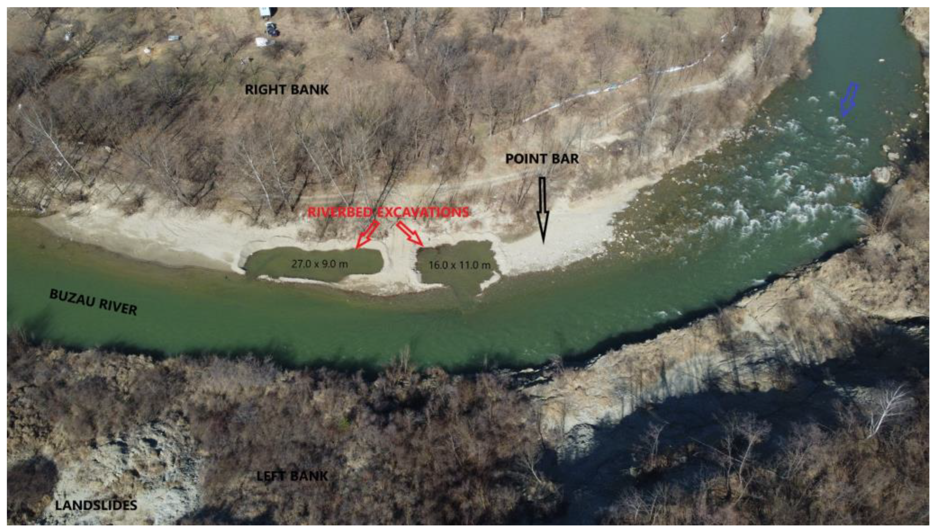
In order to verify that the mining of the bed material had been conducted legally, the valid licenses for sand and gravel mining from the river beds at the date of the analysis were reviewed. It was found that along the Buzău River only 43 were granted, but the nearest licensed mining permit was downstream of the studied location studied, approximately 15 km away. Finally, the exact dimensions of the locations of the extractions were measured in a sub-sequent field survey. The thickness of the excavated material was 0.75 m. Thus, this enabled us to estimate the maximum total volume of the material removed from the alluvial deposit that was 314 m3 (Figure 8).

3.2. The Kallifitos Torrent (Greece)

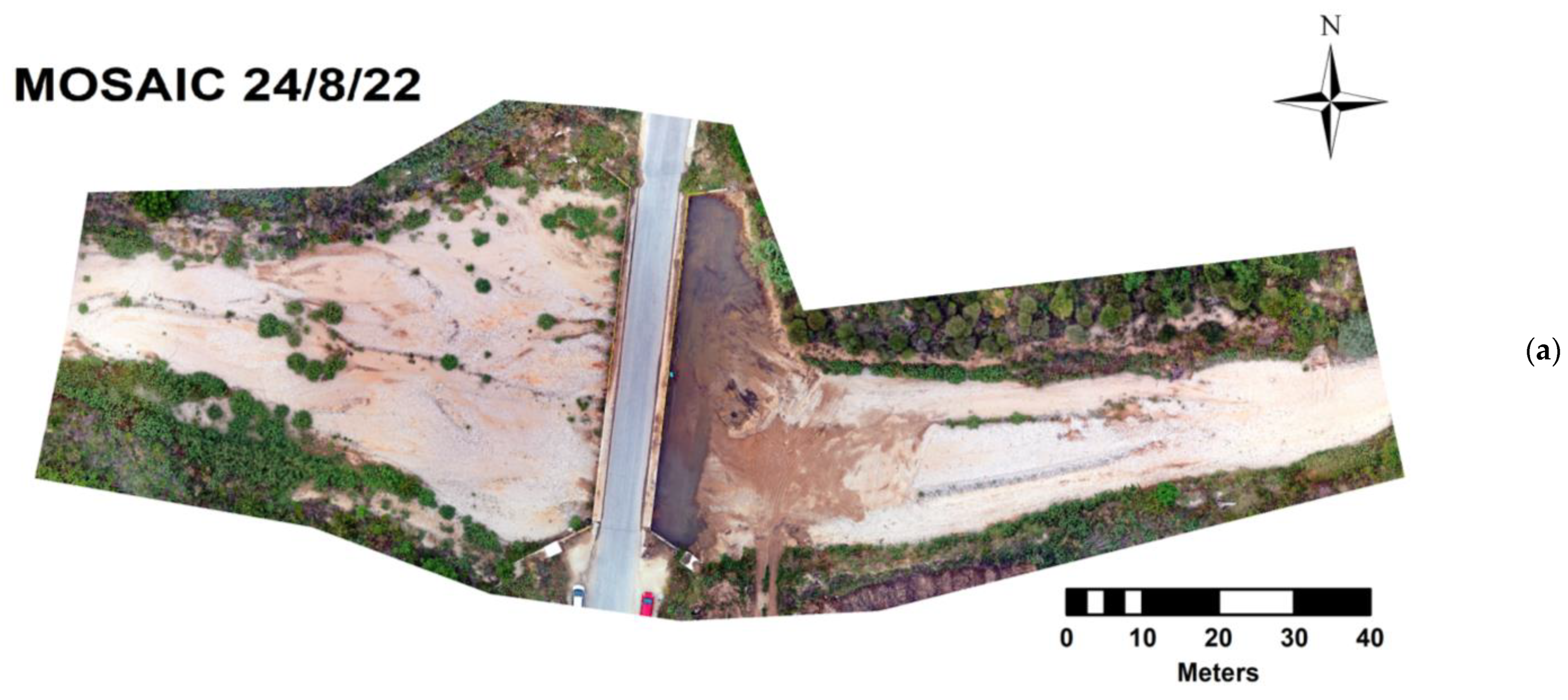
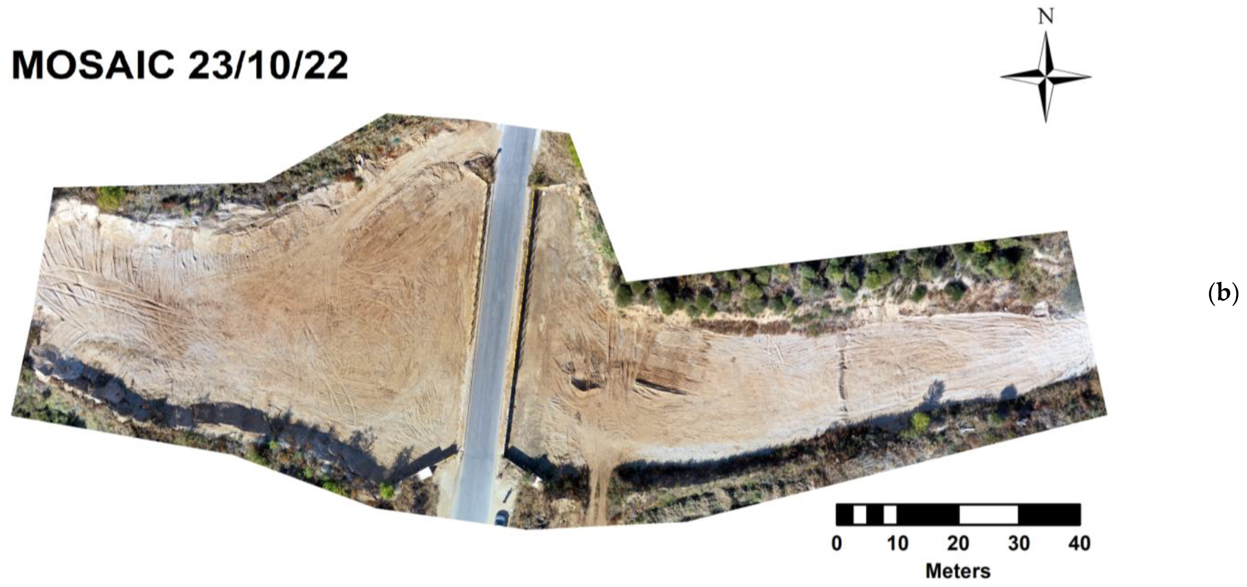
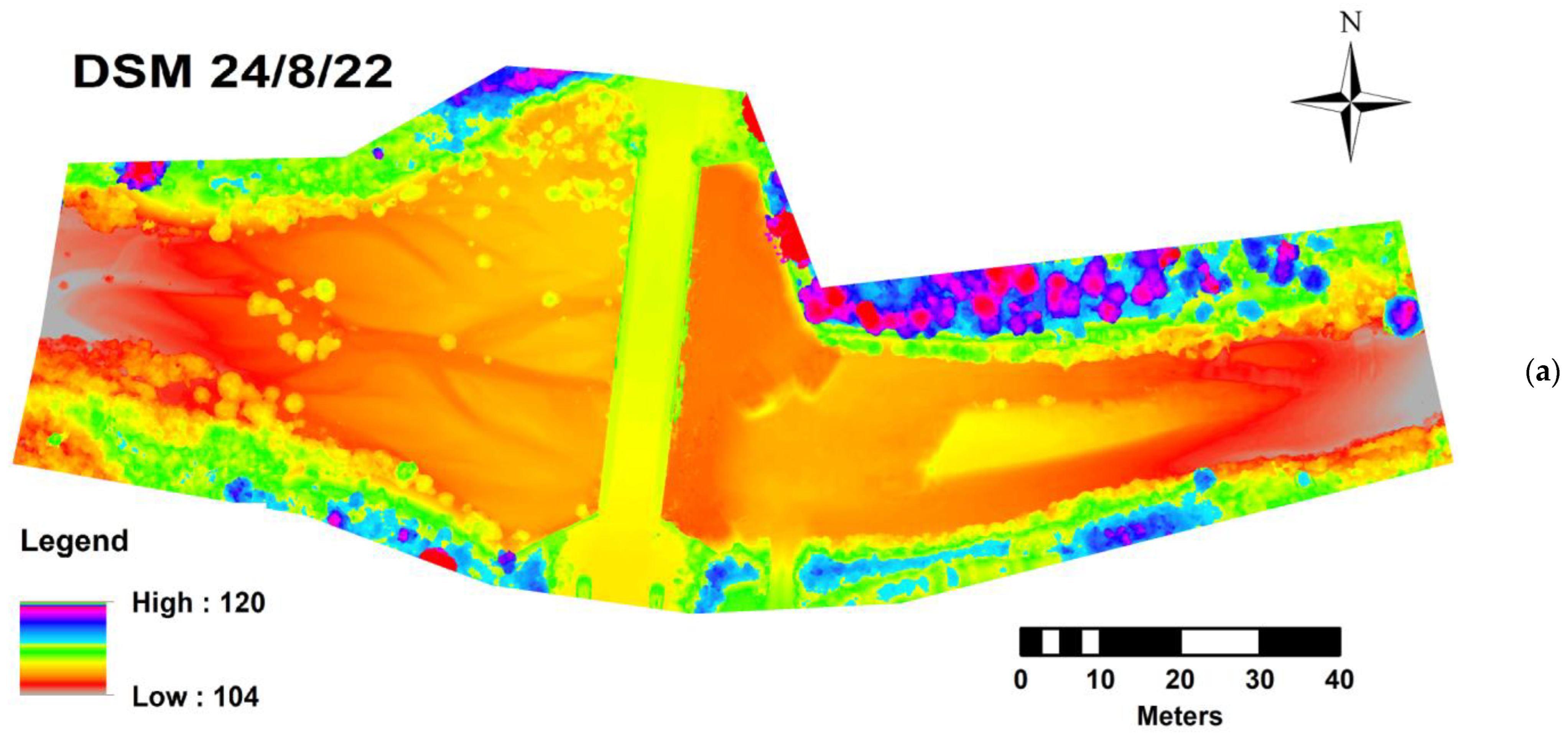
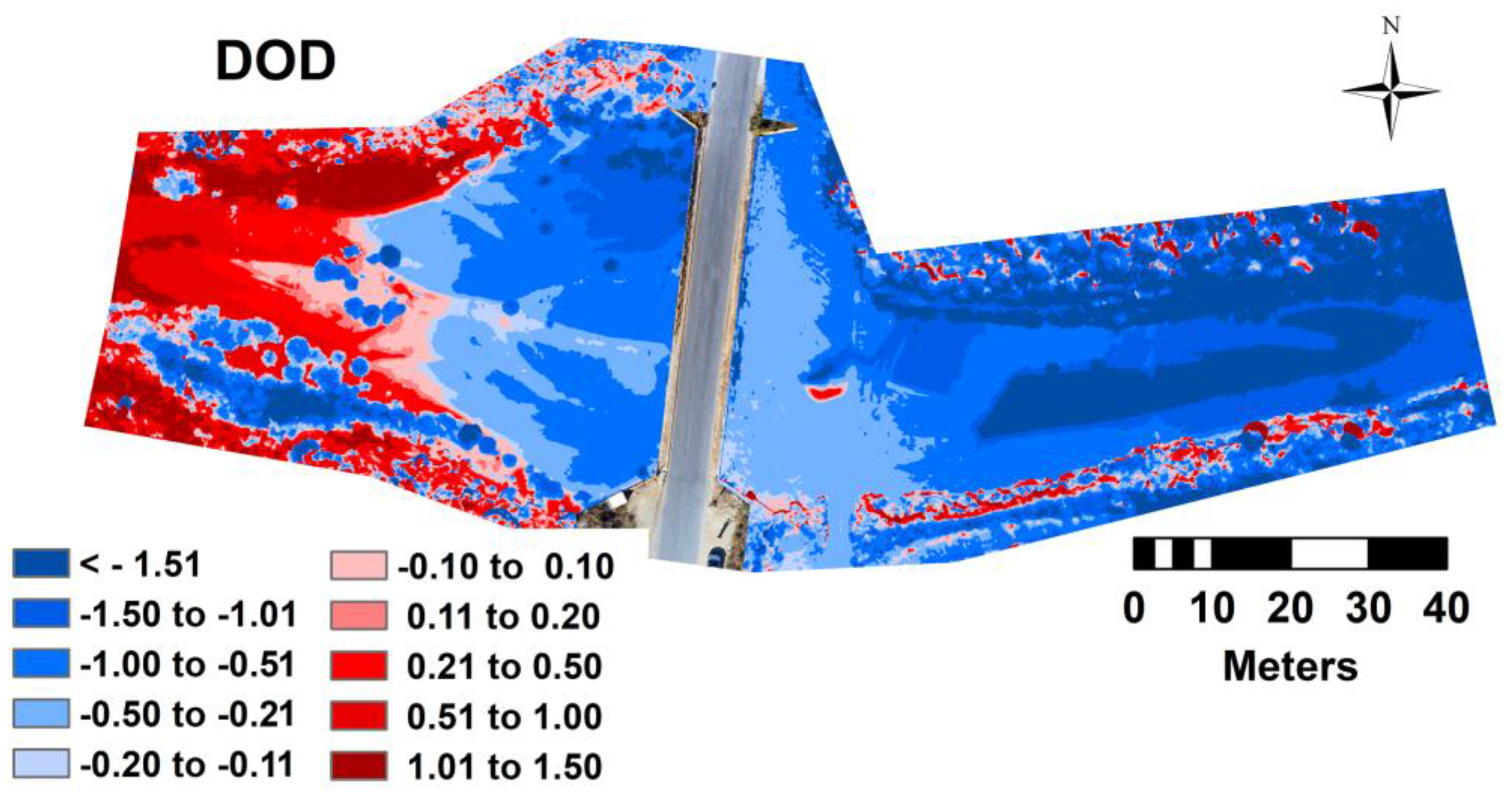
According to the produced orthomosaics and DSMs (Figure 9 and Figure 10, respectively), it is clearly visible that the extraction happened between the two dates (a few days before the 2nd flight). During August, there was water presence near the bridge, as well as vegetation in the streambed. The main flow paths were also visible at the left part of the torrent, especially in the DSM (Figure 10a), and an island was formed in the right part of the torrent. Those characteristics were leveled during the anthropogenic excavation. A significant observation is that the left part of the torrent now has higher altitude, although the torrent flows from east to west. This is an alteration caused by the excavators which transferred material to this part. As mentioned before, the DoD refers to the difference between the two DSMs derived from the UAV-based surveys. The DoD (see Figure 11) was classified to 10 classes of elevation changes (in meters) based on the natural brakes of the values’ range, specifically:
  • <-1.51;
  • -1.50 to -1.01;
  • -1.00 to -0.51;
  • -0.50 to -0.21;
  • -0.20 to -0.11;
  • -0.10 to 0.10;
  • 0.11 to 0.20;
  • 0.21 to 0.50;
  • 0.51 to 1.00;
  • 1.01 to 1.50;
  • >1.51
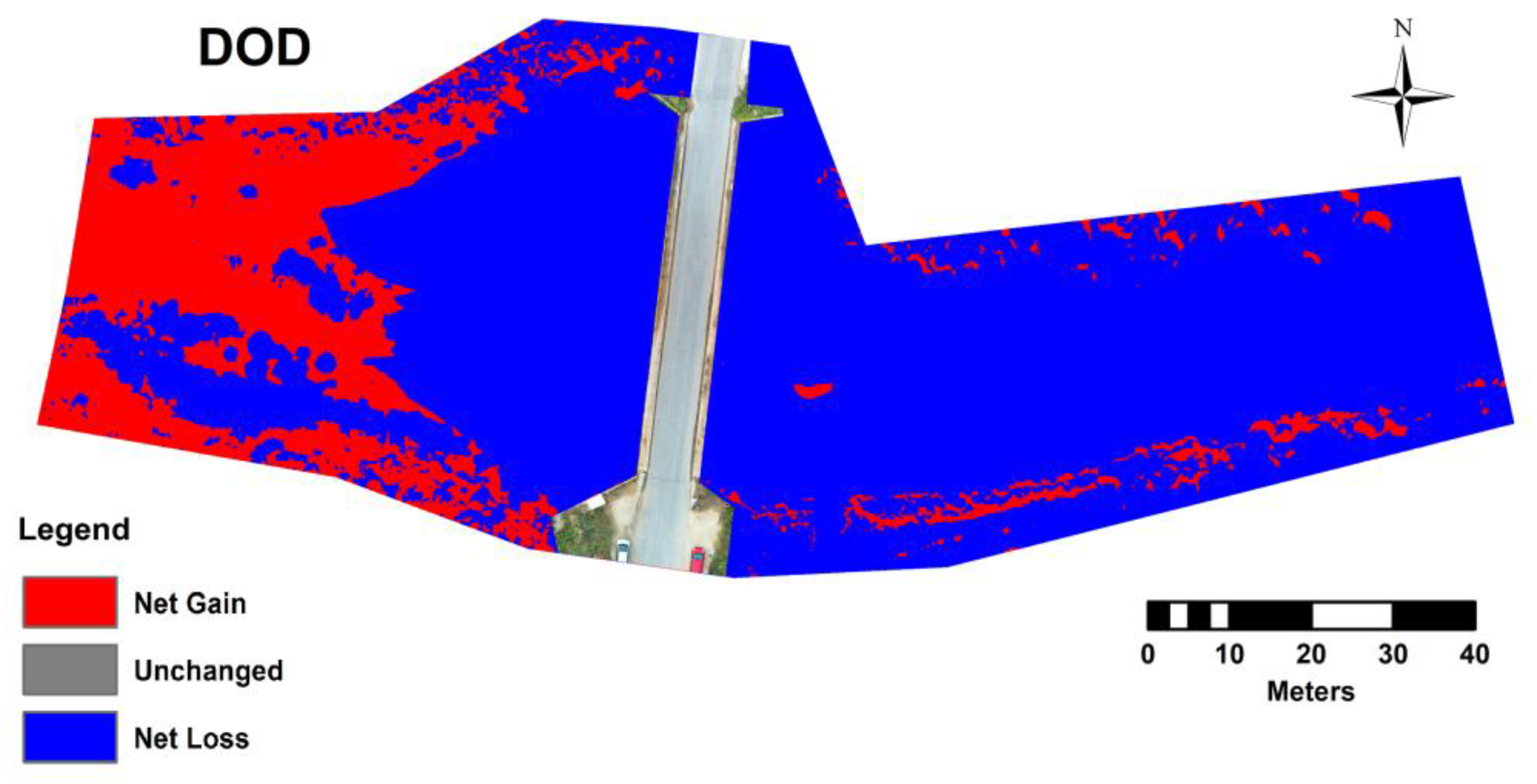
In addition, the cut-fill process, in the ArcGIS spatial analysis toolbox, enable us to calculate the volume of extracted material (see Figure 12). The unchanged elevation area was negligible and equal to 0.05 m2. An area of 6329.41 m2 resulted to a volume of soil loss equal to 5913.57 m3 (net loss). In contrast, an area of 1658.70 m2, located at the west part of the captured image, resulted to a volume of deposits equal to 1032.91 m3 (net gained); the excavator moved at this location part of the material. Eventually, the total extracted material was the subtraction of the previous numbers that resulted to 4880.66 m3. Generally, the specific part is “suffering” over time from many natural geomorphologic changes but also from anthropogenic alterations as depicted in Figure 13.
Furthermore, research in the database of relevant sand permissions given by the responsibility Authority (Decentralized Region of Eastern Macedonia and Thrace), resulted to zero entries concerning the specific torrent. In many cases, such activities in Greece are subject to Article 4 of Law 4258/2014 “as cleaning-removal of alluvium from the watercourse bed meaning any work, with the exception of sand extraction, which aims to clean the bed of portable materials or other obstacles that make it difficult for the waters of the watercourse to flow freely” [74]. The concept “cleaning-removal of alluvium” is indirectly related to the for the purpose of carrying out the settlement and anti-flood protection projects as both are being carried out works seek to remove and/or reduce the flood risk and consequently avoid it adverse effects on the natural and socio-economic environment. These cleanings should in no way be confused with forest cleanings (phytotechnical works), which are carried out by the Forestry Services following the preparation of a relevant study and whose main objective is fire protection, facilitating the access of the fire brigade vehicles in the event of a fire, but also the fulfillment of forestry purposes management in general [75,76].

4. Discussion

The Water Framework Directive 2000/60/CE is the fundamental European tool on water management. This Directive promotes the concept of sustainable river basin management, by establishing a unitary framework for water protection that prevents water pollution, promotes the conservation and enhancement of aquatic ecosystems, as well as the sustainable use of water resources in the long-term; thus, it ensures the gradual improvement of water quality for future generations [77].
Fluvio-geomorphological research in riverine environments is an essential scientific field for the sustainable and science-based implementation of the Water Directive [78,79]. A main focal interest of researchers is the improvement of the monitoring methods [80,81]. The identification of new cost-effective and accurate methods for researching alluvial deposits in river beds, as well as their protection, is necessary given the importance of both bed sediment composition and accelerated erosion rates, in regard of stream bank widening and channel incision that consequently impact the overall health of the riverine ecosystems [82,83].
The results obtained in this study help improve several methodological issues, highlighted in previous studies in regard to the real-time identification of the illegal mining from the river beds [84]. The use of UAV and satellite imagery contributes to the development of a cost-effective methodology because vast areas can be covered in a relatively short time with relatively few personnel. This type of spatial information provided by these images is essential for the understanding and establishing the spatial timeline of the removal of sand/gravel from the river beds. It needs to be noted that the correlation of the mining sites between the images obtained through the UAVs and the satellite images needs to be further validated with actual field measurements.
Achieving the objectives of this study (e.g., identifying illegal mining sites) while providing high quality results can be hampered by: (a) the lack of satellite images with a high resolution for the period of interest; (b) the weather conditions not allowing the UAV to fly to capture certain events; and (c) the manifestation of a hydrological regime of high waters and floods that reshape the morphology of the riverbed. Such events can remove the traces of the mining of the material from the river bed. The monitoring activity for the Romanian site proved that the most numerous deviations (exceeding the perimeter or the depth of the extractions) were recorded accurately before the occurrence of the floods or high river flows. As for the Greek site, we spotted anthropogenic excavations that altered the morphology of the torrent bed. There were places that the elevation was altered (filled by material) in a way that may act as an obstacle and cause floods near and left side of the bridge.
Overall, the obtained results of this study represent a significant improvement in the monitoring of rivers and especially of fluvio-geomorphological disturbances (e.g., mining) that take place at river beds and banks. This method can be utilized by the responsible management authorities in order to monitor the mining, especially the illegal ones, but also those who have permits in order to evaluate if they follow the permit agreements (e.g., over-excavated area and volume). Of course, the application of the method can be used for monitoring many other illegal activities along riverine ecosystems, for example stream bank disturbances, the creation of illegal dams to hold water, the construction of roads along or in the channel, the removal of vegetation, and garbage dumping. Successful integrated water resources management needs to also consider unintended fluvio-geomorphological disturbances (both natural and anthropogenic) that can cause serious negative effects in order to mitigate erosion rates beyond the natural ones [85,86]. This method can provide science-based insights on when such disturbances and under what conditions they occur thus helping managers find sustainable and long-term solution that should be based on nature-based solution principles [87].

5. Conclusions

The results of this study showcase that the use of UAVs can quickly and accurately identify sand and gravel mining sites along river and torrent beds. In addition, by combining the UAV images with satellite images that have daily frequency, permits to establish the exact time the mining took place. The images obtained in the presented methodology provide science-based evidence that will allow the implementation of penalties for illegal mining by the responsible management authorities. This specific methodology can be applied in both straight and meandering river and torrent channels (when banks and beds are exposed with no or limited vegetation cover) that are difficult to access, and allows for frequent visits to inspect for illegal extractions. Achieving a low-cost monitoring method will lead in its more widespread adoption, while at the same time it will help authorities reduce these illegal activities, thus better protecting riverine ecosystems. Finally, this study also highlights the need for an interdisciplinary approach that capitalizes on new technologies in order to implement sustainable and long-term water management, land use planning, and natural environment conservation.

Author Contributions

Conceptualization, D.C.D.; methodology, P.D.K., D.C.D. and G.V.D.; validation, D.C.D.; formal analysis, D.C.D.; investigation, G.T.G. and G.V.D.; resources, G.N.Z.; data curation, P.D.K., G.T.G., D.C.D. and G.V.D.; writing—original draft preparation, D.C.D.; writing—review and editing, D.C.D., G.N.Z. and P.D.K.; visualization, D.C.D.; supervision, P.D.K.; project administration, G.N.Z. All authors have read and agreed to the published version of the manuscript.

Funding

The current work was realized in frames of the Joint Operational Black Sea Programme 2014–2020, the Project BSB 963 “Protect-Streams-4-Sea”, with the financial assistance of the European Union. The content of this publication is the sole responsibility of the authors and in no case should be considered to reflect the views of the European Union.

Institutional Review Board Statement

Not applicable.

Informed Consent Statement

Not applicable.

Data Availability Statement

Not applicable.

Acknowledgments

PlanetScope, the PlanetScope satellite constellation consists of multiple launches of groups of individual CubeSats (DOVEs).

Conflicts of Interest

The authors declare no conflict of interest. The funders had no role in the design of the study; in the collection, analyses, or interpretation of data; in the writing of the manuscript; or in the decision to publish the results.

References

  1. Bendixen, M.; Iversen, L.L.; Best, J.; Franks, D.M.; Hackney, C.R.; Latrubesse, E.M.; Tusting, L.S. Sand, gravel, and UN Sustainable Development Goals: Conflicts, synergies, and pathways forward. One Earth 2021, 4, 1095–1111. [Google Scholar] [CrossRef]
  2. Fainisi, F.; Fainisi, V.A. Comparative analysis on the regulation of mineral resources in the member states of the European Union. Econ. Manag. Financ. Mark. 2017, 12, 248–269. [Google Scholar]
  3. Law of Water 107/1996, with subsequent amendments. Published in Monitorul Oficial no. 244/1996, Law of Environment 137/1995, with subsequent amendments. Published in Monitorul Oficial no. 304/30/1995.
  4. UNECE. Environmental Performance Review of Romania, 3rd ed.; United Nations: Geneva, Switzerland, November 2021. [Google Scholar]
  5. Podimata, M.V.; Yannopoulos, P.C. A conceptual approach to model sand–gravel extraction from rivers based on a game theory perspective. J. Environ. Plan. Manag. 2016, 59, 120–141. [Google Scholar] [CrossRef]
  6. Peduzzi, P. Sand, rarer than one thinks. Environ. Dev. 2014, 11, 208–218. [Google Scholar]
  7. Amiri-Tokaldany, E.; Darby, S.E.; Tosswell, P. Bank stability analysis for predicting reach scale land loss and sediment yield. J. Am. Water Resour. Assoc. 2003, 39, 897–909. [Google Scholar] [CrossRef]
  8. Dotterweich, M. The history of soil erosion and fluvial deposits in small catchments of central Europe: Deciphering the long-term interaction between humans and the environment—A review. Geomorphology 2008, 101, 192–208. [Google Scholar] [CrossRef]
  9. Koehnken, L.; Rintoul, M.S.; Goichot, M.; Tickner, D.; Loftus, A.C.; Acreman, M.C. Impacts of riverine sand mining on freshwater ecosystems: A review of the scientific evidence and guidance for future research. River Res. Appl. 2020, 36, 362–370. [Google Scholar] [CrossRef] [Green Version]
  10. Tiess, G. Minerals policy in Europe: Some recent developments. Resour. Policy 2010, 35, 190–198. [Google Scholar] [CrossRef]
  11. Kivinen, S.; Kotilainen, J.; Kumpula, T. Mining conflicts in the European Union: Environmental and political perspectives. Fennia 2020, 198, 163–179. [Google Scholar] [CrossRef]
  12. Bringezu, S. Towards sustainable resource management in the European Union. Wupp. Pap. 2002, 121, 50. [Google Scholar]
  13. UNEP. Sand and Sustainability: Finding New Solutions for Environmental Governance of Global Sand Resources; United Nations Environment Programme: Geneva, Switzerland, 2019. [Google Scholar]
  14. De Leeuw, N.H.; Catlow, C.R.A.; King, H.E.; Putnis, A.; Muralidharan, K.; Deymier, P.; Stimpfl, M.; Drake, M.J. Where on Earth has our water come from? ChemComm 2010, 46, 8923–8925. [Google Scholar] [CrossRef] [Green Version]
  15. Drozdz, M. Maps and protest. In International Encyclopedia of Human Geography; Kobayashi, A., Ed.; Elsevier: Amsterdam, The Netherlands, 2020; pp. 367–378. [Google Scholar] [CrossRef]
  16. Mayes, W.M.; Jarvis, A.P.; Burke, I.T.; Walton, M.; Feigl, V.; Klebercz, O.; Gruiz, K. Dispersal and attenuation of trace contaminants downstream of the Ajka bauxite residue (red mud) depository failure, Hungary. Environ. Sci. Technol. 2011, 45, 5147–5155. [Google Scholar] [CrossRef]
  17. Kosyan, R.D.; Velikova, V.N. Coastal zone–Terra (and aqua) incognita–Integrated coastal zone management in the Black Sea. Estuar. Coast. Shelf Sci. 2016, 169, A1–A16. [Google Scholar] [CrossRef]
  18. Żuk, L.; Królewicz, S. Uses of Sentinel-1 and -2 Images in Heritage Management: A Case Study from Lednica Landscape Park (Poland). Geosciences 2022, 12, 159. [Google Scholar] [CrossRef]
  19. Guneroglu, A.; Dihkan, M.; Karsli, F. Dynamic management of the coasts: Marine spatial planning. Proc. Inst. Civ. Eng. Marit. Eng. 2014, 167, 144–153. [Google Scholar] [CrossRef]
  20. Carpa, R.; Maior, M.C.; Dejeu, C. Romanian ecosystems need EU protection. Science 2017, 358, 880–881. [Google Scholar] [CrossRef]
  21. Tătui, F.; Pîrvan, M.; Popa, M.; Aydogan, B.; Ayat, B.; Görmüș, T.; Korzinine, D.; Văidianu, N.; Vespremeanu-Stroe, A.; Zăinescu, F.; et al. The Black Sea coastline erosion: Index-based sensitivity assessment and management-related issues. Ocean Coast. Manag. 2019, 182, 104949. [Google Scholar] [CrossRef]
  22. Pop, D.A.; Staicu, G. Extraction of agregates from alluvial plains. Case study: Buzău River (Romania). Acta Oecol. Carp. 2017, 10, 85–100. [Google Scholar]
  23. Costea, M. Impact of floodplain gravel mining on landforms and processes: A study case in Orlat gravel pit (Romania). Environ. Earth Sci. 2018, 77, 119. [Google Scholar] [CrossRef]
  24. Tzampoglou, P.; Loupasakis, C. Evaluating geological and geotechnical data for the study of land subsidence phenomena at the perimeter of the Amyntaio coalmine, Greece. Int. J. Min. Sci. Technol. 2018, 28, 601–612. [Google Scholar] [CrossRef]
  25. Lampou, D.; Karathanasis, C.; Zafeiratos, I.G.; Tzeferis, P.G. A Roadmap for Exploration and Exploitation of Mineral Raw Materials in Greece. Mater. Proc. 2021, 5, 80. [Google Scholar]
  26. Charalampides, G.; Vatalis, K.I.; Platias, S.; Karayannis, V. The Contribution of Industrial Minerals to Sustainable Recovery of Greek Economy. Procedia Econ. Financ. 2014, 14, 128–136. [Google Scholar] [CrossRef] [Green Version]
  27. Modis, K.; Sideri, D.; Roumpos, C.; Binet, H.; Pavloudakis, F.; Paraskevis, N. Geostatistical Modeling of Overburden Lithofacies to Optimize Continuous Mining in the Ptolemais Lignite Mines, Greece. Minerals 2022, 12, 1109. [Google Scholar] [CrossRef]
  28. Tzampoglou, P.; Loupasakis, C. Numerical simulation of the factors causing land subsidence due to overexploitation of the aquifer in the Amyntaio open coal mine, Greece. HydroResearch 2019, 1, 8–24. [Google Scholar] [CrossRef]
  29. Velegrakis, A.F.; Ballay, A.; Poulos, S.E.; Radzevičius, R.; Bellec, V.K.; Manso, F. European marine aggregates resources: Origins, usage, prospecting and dredging techniques. J. Coast. Res. 2010, S1, 1–14. [Google Scholar] [CrossRef]
  30. Woodward, J.C.; Nicholas, A.; Christopoulos, G.; Macklin, M. Modelling and monitoring the impact of dam construction and gravel extraction on rates of bank erosion in the Alfios River, Peloponnese, western Greece. In Fluvial Processes and Environmental Change; Brown, A.G., Quine, T.A., Eds.; John Wiley & Sons Ltd.: Hoboken, NJ, USA, 1999; pp. 117–137. [Google Scholar]
  31. Bathrellos, G.D.; Skilodimou, H.D. Estimation of sand and gravel extraction sites. Z. Für Geomorphol. 2022, 63, 313–328. [Google Scholar] [CrossRef]
  32. Costea, G.; Pusch, M.T.; Bănăduc, D.; Cosmoiu, D.; Curtean-Bănăduc, A. A review of hydropower plants in Romania: Distribution, current knowledge, and their effects on fish in headwater streams. Renew. Sust. Energ. 2021, 145, 111003. [Google Scholar] [CrossRef]
  33. Mohamad, N.; Khanan, M.F.A.; Musliman, I.A.; Kadir, W.H.W.; Ahmad, A.; Rahman, M.Z.A.; Jamal, M.H.; Zabidi, M.; Suaib, N.M.; Zain, R.M. Spatio-temporal analysis of river morphological changes and erosion detection using very high resolution satellite image. IOP Conf. Ser. Earth Environ. Sci. 2018, 169, 012020. [Google Scholar] [CrossRef]
  34. Koutalakis, P.D.; Tzoraki, O.A.; Prazioutis, G.I.; Gkiatas, G.T.; Zaimes, G.N. Can Drones Map Earth Cracks? Landslide Measurements in North Greece Using UAV Photogrammetry for Nature-Based Solutions. Sustainability 2021, 13, 4697. [Google Scholar] [CrossRef]
  35. Langat, P.K.; Kumar, L.; Koech, R. Monitoring river channel dynamics using remote sensing and GIS techniques. Geomorphology 2019, 325, 92–102. [Google Scholar] [CrossRef]
  36. Conforti, M.; Mercuri, M.; Borrelli, L. Morphological changes detection of a large earthflow using archived images, lidar-derived DTM, and UAV-based remote sensing. Remote Sens. 2020, 13, 120. [Google Scholar] [CrossRef]
  37. Akay, S.S.; Ozcan, O.; Sen, O.L. Modeling morphodynamic processes in a meandering river with unmanned aerial vehicle-based measurements. J. Appl. Remote Sens. 2019, 13, 044523. [Google Scholar] [CrossRef]
  38. Ngadiman, N.; Kasan, N.M.; Hamzan, F.H.; Zakaria, S.F.S. Riverbank Slope Erosion Monitoring using Unmanned Aerial Vehicle (UAV). MARI 2021, 2, 13–24. [Google Scholar]
  39. Zaimes, G.N.; Ioannou, K.; Iakovoglou, V.; Kosmadakis, K.; Koutalakis, P.; Ranis, G.; Emmanouloudis, D.; Schultz, R.C. Improving soil erosion prevention in Greece with new tools. J. Eng. Sci. Technol. 2016, 9, 66–71. [Google Scholar]
  40. Duró, G.; Crosato, A.; Kleinhans, M.G.; Uijttewaal, W.S.J. Bank Erosion Processes Measured With UAV-SfM Along Complex Banklines of a Straight Mid-Sized River Reach. Earth Surf. Dyn. 2018, 6, 933–953. [Google Scholar] [CrossRef] [Green Version]
  41. Hassanein, M.; El-Sheimy, N. An efficient weed detection procedure using low-cost UAV imagery system for precision agriculture applications. Int. Arch. Photogramm. Remote Sens. Spat. Inf. Sci. 2018, 621, 181–187. [Google Scholar] [CrossRef]
  42. Huang, Y.; Reddy, K.N.; Fletcher, R.S.; Pennington, D. UAV low-altitude remote sensing for precision weed management. Weed Technol. 2018, 32, 2–6. [Google Scholar] [CrossRef]
  43. Zhang, Z.; Flores, P.; Igathinathane, C.; Naik, D.L.; Kiran, R.; Ransom, J.K. Wheat Lodging Detection from UAS Imagery Using Machine Learning Algorithms. Remote Sens. 2020, 12, 1838. [Google Scholar] [CrossRef]
  44. Balestrieri, E.; Daponte, P.; De Vito, L.; Lamonaca, F. Sensors and measurements for unmanned systems: An overview. Sensors 2021, 21, 1518. [Google Scholar] [CrossRef]
  45. Meinen, B.U.; Robinson, D.T. Streambank topography: An accuracy assessment of UAV-based and traditional 3D reconstructions. Int. J. Remote Sens. 2020, 41, 1–18. [Google Scholar] [CrossRef] [Green Version]
  46. Zaimes, G.N.; Tufekcioglu, M.; Diaconu, D.; Trombitsky, I.; Ghulijanyan, A.; Marinescu, M.; Koutalakis, P.; Iakovoglou, V. Protect-Streams-4-Sea–A new Black Sea programme project. In Proceedings of the International Conference on “Environmental Toxicants in Freshwater and Marine Ecosystems in the Black Sea Basin”, Kavala, Greece, 8–11 September 2020; pp. 57–58. [Google Scholar]
  47. Bălteanu, D.; Jurchescu, M.; Surdeanu, V.; Ionita, I.; Goran, C.; Urdea, P.; Rădoane, M.; Rădoane, N.; Sima, M. Recent landform evolution in the Romanian Carpathians and Pericarpathian Regions. In Recent Landform Evolution: The Carpatho–Balkan–Dinaric Region; Lóczy, D., Stankoviansky, M., Kotarba, A., Eds.; Springer Geography: Berlin/Heidelberg, Germany, 2012. [Google Scholar]
  48. Minea, I.S. Râurile din Bazinul Buzău. Consideraţii Hidrografice şi Hidrologice; Editura Alpha MDN: Buzău, Romania, 2011; 306p. [Google Scholar]
  49. Zaimes, G.N.; Emmanouloudis, D. Sustainable Management of the Freshwater Resources of Greece. J. Eng. Sci. Technol. 2012, 5, 77–82. [Google Scholar] [CrossRef]
  50. Skoulikidis, N.T.; Sabater, S.; Datry, T.; Morais, M.M.; Buffagni, A.; Dörflinger, G.; Zogaris, S.; del Mar Sánchez-Montoya, M.; Bonada, N.; Kalogianni, E.; et al. Non-perennial Mediterranean rivers in Europe: Status, pressures, and challenges for research and management. Sci. Total Environ. 2017, 577, 1–18. [Google Scholar] [CrossRef] [PubMed]
  51. Gkiatas, G.; Kasapidis, I.; Koutalakis, P.; Iakovoglou, V.; Savvopoulou, A.; Germantzidis, I.; Zaimes, G.N. Enhancing urban and sub-urban riparian areas through ecosystem services and ecotourism activities. Water Supply 2021, 21, 2974–2988. [Google Scholar] [CrossRef]
  52. Pennos, C.; Lauritzen, S.E.; Pechlivanidou, S.; Sotiriadis, Y. Geomorphic constrains on the evolution of the Aggitis River Basin Northern Greece (a preliminary report). BGSG 2016, 50, 365–373. [Google Scholar] [CrossRef] [Green Version]
  53. Lespez, L. Geomorphic responses to long-term land use changes in Eastern Macedonia (Greece). Catena 2003, 51, 181–208. [Google Scholar] [CrossRef]
  54. Gkiatas, G.T.; Koutalakis, P.D.; Kasapidis, I.K.; Iakovoglou, V.; Zaimes, G.N. Monitoring and Quantifying the Fluvio-Geomorphological Changes in a Torrent Channel Using Images from Unmanned Aerial Vehicles. Hydrology 2022, 9, 184. [Google Scholar] [CrossRef]
  55. Koutalakis, P.; Tzoraki, O.; Zaimes, G.N. Detecting riverbank changes with remote sensing tools. Case study: Aggitis River in Greece. Ann. Univ. Dunarea Jos Galati Fascicle II Math. Phys. Theor. Mech. 2019, 42, 134–142. [Google Scholar] [CrossRef]
  56. Yaacoub, J.P.; Noura, H.; Salman, O.; Chehab, A. Security analysis of drones systems: Attacks, limitations, and recommendations. Internet Things 2020, 11, 100218. [Google Scholar] [CrossRef]
  57. Giordan, D.; Manconi, A.; Facello, A.; Baldo, M.; Allasia, P.; Dutto, F. Brief Communication: The use of an unmanned aerial vehicle in a rockfall emergency scenario. Nat. Hazards Earth Syst. Sci. 2015, 15, 163–169. [Google Scholar] [CrossRef] [Green Version]
  58. Jeziorska, J. UAS for wetland mapping and hydrological modeling. Remote Sens. 2019, 11, 1997. [Google Scholar] [CrossRef] [Green Version]
  59. Colomina, I.; Molina, P. Unmanned aerial systems for photogrammetry and remote sensing: A review. ISPRS J. Photogramm. Remote Sens. 2014, 92, 79–97. [Google Scholar] [CrossRef] [Green Version]
  60. Manfreda, S.; McCabe, M.F.; Miller, P.E.; Lucas, R.; Pajuelo Madrigal, V.; Mallinis, G.; Ben Dor, E.; Helman, D.; Estes, L.; Ci-raolo, G.; et al. On the Use of Unmanned Aerial Systems for Environmental Monitoring. Remote Sens. 2018, 10, 641. [Google Scholar] [CrossRef] [Green Version]
  61. Alamouri, A.; Lampert, A.; Gerke, M. An Exploratory Investigation of UAS Regulations in Europe and the Impact on Effective Use and Economic Potential. Drones 2021, 5, 63. [Google Scholar] [CrossRef]
  62. Cienciała, A.; Sobura, S.; Sobolewska-Mikulska, K. Optimising Land Consolidation by Implementing UAV Technology. Sustainability 2022, 14, 4412. [Google Scholar] [CrossRef]
  63. Douka, A.K. Drones and environmental protection law in Germany and Greece. In Proceedings of the International Conference on Protection and Restoration of the Environment XIV, Thessaloniki, Greece, 3–6 July 2018. [Google Scholar]
  64. Ruzgienė, B.; Berteška, T.; Gečyte, S.; Jakubauskienė, E.; Aksamitauskas, V.Č. The surface modelling based on UAV Photogrammetry and qualitative estimation. Measurement 2015, 73, 619–627. [Google Scholar] [CrossRef]
  65. Šiljeg, A.; Domazetović, F.; Marić, I.; Lončar, N.; Panđa, L. New method for automated quantification of vertical spatio-temporal changes within gully cross-sections based on very-high-resolution models. Remote Sens. 2021, 13, 321. [Google Scholar] [CrossRef]
  66. Domazetović, F.; Šiljeg, A.; Marić, I.; Faričić, J.; Vassilakis, E.; Panđa, L. Automated Coastline Extraction Using the Very High Resolution WorldView (WV) Satellite Imagery and Developed Coastline Extraction Tool (CET). Appl. Sci. 2021, 11, 9482. [Google Scholar] [CrossRef]
  67. Neverman, A.J.; Fuller, I.C.; Procter, J.N. Application of geomorphic change detection (GCD) to quantify morphological budgeting error in a New Zealand gravel-bed river: A case study from the Makaroro river, Hawke’s bay. J. Hydrol. N. Z. 2016, 55, 45–63. [Google Scholar]
  68. Wheaton, J.M.; Brasington, J.; Darby, S.E.; Sear, D.A. Accounting for uncertainty in DEMs from repeat topographic surveys: Improved sediment budgets. Earth Surf. Process. Landf. 2010, 35, 136–156. [Google Scholar] [CrossRef]
  69. Milan, D.J.; Heritage, G.L.; Large, A.R.; Fuller, I.C. Filtering spatial error from DEMs: Implications for morphological change estimation. Geomorphology 2011, 125, 160–171. [Google Scholar] [CrossRef]
  70. Our Constellation Soaring Through Space and Time. Available online: https://www.planet.com/our-constellations/ (accessed on 26 October 2022).
  71. Planetscope—Dove Satellite Constellation (3m). Additional Planet Labs SuperDoves Join the PlanetScope Satellite Constellation. Available online: https://www.satimagingcorp.com/satellite-sensors/other-satellite-sensors/dove-3m/ (accessed on 26 October 2022).
  72. Understanding PlanetScope Instruments. Available online: https://developers.planet.com/docs/apis/data/sensors/ (accessed on 26 October 2022).
  73. Satellite Imagery and Archive—Planet Labs. Available online: https://www.planet.com (accessed on 26 October 2022).
  74. Danııl, E.; Michas, S.; Aerakis, G. Hydrologic issues in demarcation studies of watercourses in Greece. In Proceedings of the 15th International Conference on Environmental Science and Technology, Rhodes, Greece, 31 August–2 September 2017. [Google Scholar]
  75. Palaiologou, P.; Kalabokidis, K.; Ager, A.A.; Day, M.A. Development of comprehensive fuel management strategies for reducing wildfire risk in Greece. Forests 2020, 11, 789. [Google Scholar] [CrossRef]
  76. Zaimes, G.N.; Kasapidis, I.; Gkiatas, G.; Pagonis, G.; Savvopoulou, A.; Iakovoglou, V. Targeted placement of soil erosion prevention works after wildfires. In Proceedings of the IOP Conference Series: Earth and Environmental Science, Online, 26–28 August 2020. [Google Scholar]
  77. Directive 2000/60/EC of the European Parliament and of the Council of 23 October 2000 Establishing a Framework for Community Action in the Field of Water Policy. Available online: https://eur-lex.europa.eu/eli/dir/2000/60/2014-11-20 (accessed on 26 October 2022).
  78. Thoma, D.P.; Gupta, S.C.; Bauer, M.E.; Kirchoff, C. Airborne laser scanning for riverbank erosion assessment. Remote Sens. Environ. 2005, 95, 493–501. [Google Scholar] [CrossRef]
  79. Hassan, M.A.; Voepel, H.; Schumer, R.; Parker, G.; Fraccarollo, L. Displacement characteristics of coarse fluvial bed sediment. J. Geophys. Res. Earth Surf. 2013, 118, 155–165. [Google Scholar] [CrossRef]
  80. Diaconu, D.C.; Andronache, I.; Ahammer, H.; Ciobotaru, A.M.; Zelenakova, M.; Dinescu, R.; Pozdnyakov, A.V.; Chupikova, S.A. Fractal drainage model—A new approach to determinate the complexity of watershed. Acta Montan. Slovaca 2018, 22, 12–21. [Google Scholar]
  81. Zaimes, G.N.; Schultz, R.C. Stream bed substrate composition adjacent to different riparian land-uses in Iowa, USA. Ecol. Eng. 2011, 37, 1692–1699. [Google Scholar] [CrossRef]
  82. Aher, S.P.; Bairagi, S.I.; Deshmukh, P.P.; Gaikwad, R.D. River change detection and bank erosion identification using topo-graphical and remote sensing data. Int. J. Inf. Syst. Proj. Manag. 2012, 2, 1–7. [Google Scholar]
  83. Longoni, L.; Papini, M.; Brambilla, D.; Barazzetti, L.; Roncoroni, F.; Scaioni, M.; Ivanov, V.I. Monitoring Riverbank Erosion in Mountain Catchments Using Terrestrial Laser Scanning. Remote Sens. 2016, 8, 241. [Google Scholar] [CrossRef] [Green Version]
  84. Chen, Y.Y.; Zhang, H.D.; Xu, M. The Coverage Problem in UAV Network: A Survey Book Group Author: IEEE. In Proceedings of the 2014 International Conference on Computing, Communication and Networking Technologies (ICCCNT), Hefei, China, 11–13 July 2014. [Google Scholar]
  85. Florsheim, J.L.; Mount, J.F.; Chin, A. Bank erosion as a desirable attribute of rivers. BioScience 2008, 58, 519–529. [Google Scholar] [CrossRef] [Green Version]
  86. Vietz, G.J.; Lintern, A.; Webb, J.A.; Straccione, D. River Bank Erosion and the Influence of Environmental Flow Management. Environ. Manag. 2017, 61, 454–468. [Google Scholar] [CrossRef]
  87. Zaimes, G.N.; Tardio, G.; Iakovoglou, V.; Gimenez, M.; Garcia-Rodriguez, J.L.; Sangalli, P. New tools and approaches to promote soil and water bioengineering in the Mediterranean. Sci. Total Environ. 2019, 693, 133677. [Google Scholar] [CrossRef]
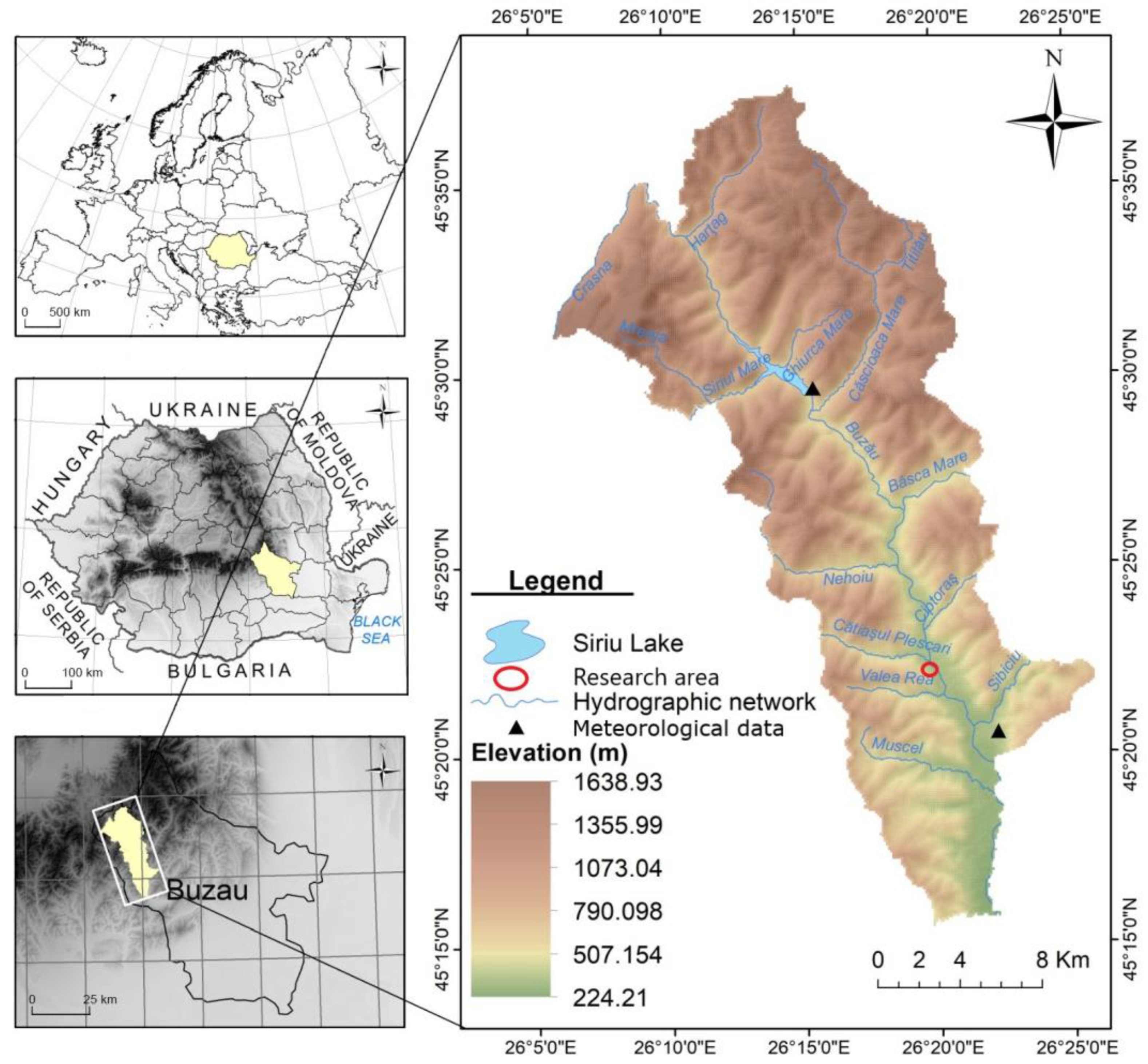
Figure 1. The pilot area of Buzău River for the project BSB963 “Protect-Streams-4-Sea”.
Sustainability 15 01944 g001
Figure 2. The Aggitis River Basin (in red boundaries), the stream network (in blue) and the location of the study reach of Kallifitos torrent (in yellow triangle) situated in Northern Greece.
Sustainability 15 01944 g002
Figure 3. Comparison of the most important aspects of spatial data acquisition for an Unmanned Aircraft System (UAS).
Sustainability 15 01944 g003
Figure 4. The typical acquisition and processing based on an Unmanned Aircraft System (UAS).
Sustainability 15 01944 g004
Figure 5. Planetscope satellite image of the Romanian studied river reach (25 January 2022).
Sustainability 15 01944 g005
Figure 6. Planetscope satellite image of the Romanian studied river reach (17 February 2022). Red arrows represent the locations of sand mining.
Sustainability 15 01944 g006
Figure 7. Planet Source, Skysat Satellite Image of the Romanian studied river reach from (24 November 2021).
Sustainability 15 01944 g007
Figure 8. The aerial image of the excavated river bed from the DJI Mavic Mini 2 drone taken at 100 m height.
Sustainability 15 01944 g008
Figure 9. The UAV-based orthomosaics of the Kallifitos torrent location: (a) 24 August 2022; (b) and 23 October 2022.
Sustainability 15 01944 g009aSustainability 15 01944 g009b
Figure 10. The UAV-based digital surface models (DSMs) of the Kallifitos torrent location: (a) 24 August 2022; (b) and 23 October 2022.
Sustainability 15 01944 g010aSustainability 15 01944 g010b
Figure 11. The DOD resulted from the comparison of the images between the dates 14 September 2022 and 28 October 2022. The colorized scale represents the different elevation categories (in meters).
Sustainability 15 01944 g011
Figure 12. The 3 classes comparing the changes between the 2 DSMs: (red) gained material, (grey) unchanged elevation and (blue) loss material.
Sustainability 15 01944 g012
Figure 13. Airborne/satellite images from Google Earth of the Kallifitos torrent when is (a) natural vegetated in September 2009; (b) and affected by anthropogenic alterations in January 2014.
Sustainability 15 01944 g013
Table 1. The characteristics of the satellite images.
Date of ImageSatellite Image SourceSpatial Resolution
25 January 2022PlanetScope3 m/px
17 February 2022PlanetScope3 m/px
24 November 2021Skysat0.75 m/px
Disclaimer/Publisher’s Note: The statements, opinions and data contained in all publications are solely those of the individual author(s) and contributor(s) and not of MDPI and/or the editor(s). MDPI and/or the editor(s) disclaim responsibility for any injury to people or property resulting from any ideas, methods, instructions or products referred to in the content.