Article

A Geo-Itinerary to Foster Sustainable Tourism in West African Islands: Storytelling the Evolution of the Ancient Cameroon Volcanic Line Coral Reefs

by
Maria Helena Henriques
1,* and
Keynesménio Neto
1,2
1
Department of Earth Sciences, Geosciences Centre, University of Coimbra, Rua Sílvio Lima, 3030-790 Coimbra, Portugal
2
Higher Institute of Education and Communication, University of São Tomé and Príncipe, Rua da Caixa, nº19-C.P. 546, São Tomé, São Tomé and Príncipe, 3030-790 Coimbra, Portugal
*
Author to whom correspondence should be addressed.
Sustainability 2023, 15(24), 16863; https://doi.org/10.3390/su152416863
Submission received: 21 November 2023 / Accepted: 12 December 2023 / Published: 15 December 2023

Abstract

:
This study characterizes the submerged geomorphology around Annobón, São Tomé, and Príncipe Islands, and the De Santarém–Escobar seamount in the Cameroon Volcanic Line or CVL (Gulf of Guinea, West Africa) through analyses of topographic relief and coastal bathymetry, and data from fieldwork and historical fossil collections. The clear relation between each submerged island and the seamount morphology of the CVL and the various stages of coral reef development according to Darwin’s subsidence hypothesis meets the concept of intangible geoheritage. This type of geoheritage is related to phenomena rather than to a thing, and it is usually highly evaluated by scientific communities. Academics tend to use science-based discourse to explain this theory, but it is rarely understood by non-specialist audiences. This work proposes a virtual geo-itinerary along the submerged geomorphology of the CVL islands and seamounts, which aims at telling the geohistory of the coral reefs’ origin and evolution according to Darwin’s theory, and disclosing its geoheritage contents for further sustainable uses. The resulting narrative can be used to support geotourism initiatives and to support the United Nations’ objectives for Small Island Developing States.

1. Introduction

The history of coral reef science displays one of the most interesting long-term controversial issues: the origin of coral reefs’ morphology [1,2]. While Darwin [3,4,5] suggested that the growth processes on subsiding volcanic islands are primarily responsible for the current morphology of coral reefs [6], Daly [7] argued that the effects of wave planation during low sea-level stands and coral development during subsequent high stands were the combined causes of the surface shape of current reefs [8]. According to Davis [9], the climatic oscillations in ocean level of Daly’s glacial-control theory and the intermittent subsidence and sporadic uplifts of Darwin’s theory may work together. However, more recently, Droxler and Jorry [10] claimed that the late Quaternary formation of the present-day atolls, which were formed on top of late Pliocene flat-topped banks from the Maldives archipelago and from the tropical Pacific and southwest Indian Oceans, was unaffected by the volcanic substrate, while Raja et al. [11] considered that throughout the Phanerozoic, global abiotic variables had little effect on reef volume.
Among the world’s least well-known tropical reefs are those found in West Africa’s Gulf of Guinea [12,13]. The Gulf of Guinea’s surface temperature is typically above 25 °C, and seasonal upwelling has no effect on the salinity, which is consistently less than 35% [14]. For Príncipe Island, Laborel [12] described the coral assemblages that developed in shallow waters (2–4 m depth) and rocky bottoms at the northern shore, and identified endemic species associated with some NE Brazilian ones. Reefs recognized on São Tomé Island are found in waters of an intense turquoise color at Lagoa Azul (coordinates 0°24′23.10″ N; 6°36′36.53″ E), lie in cool water below a 20–30 m depth, and are interpreted as mesophotic reef ecosystems dominated by black corals [13].
However, the submerged morphology of the offshore volcanic swells that have formed islands and seamounts (i.e., peaks characteristically of conical form that rise over 1000 m above the seafloor [15]) located in the Gulf of Guinea shows distinctive features typically attributed to submerged shallow-water carbonate platforms and coral reefs that occur when tectonic subsidence or a rising sea level exceeds carbonate accumulation and benthonic carbonate production ceases [16]. Understanding their geodynamic evolution over time because of biotic and abiotic constraints can be of great relevance to make local communities aware of the vulnerability of the present-day coral reef ecosystems of the Gulf of Guinea, which are still so little understood.
In addition to the geological heritage that can be inventoried and evaluated on each island, (e.g., [17,18,19]), the analysis of the topographic relief and nearshore bathymetry of the set of submerged geomorphological features surrounding Annobón, São Tomé and Príncipe Islands, and the De Santarém–Escobar seamount shows that they exhibit intangible geoheritage characteristics that set them apart and that were crucial in the development of geological thinking, so meeting the definition of intangible geoheritage [20]. The set of volcano-capped swells of the Gulf of Guinea provides paradigmatic examples of various stages of ancient coral reef development according to Darwin’s subsidence hypothesis subject to varying conditions of sea water level over time. In this sense, they can be framed within a thematic geo-itinerary that is most likely to be understood by general audiences and be used as a powerful educational resource. Disclosing these tangible and non-tangible geoheritage contents for further sustainable uses, namely through geotourism, can contribute to the fostering of community-based tourism and therefore assist the United Nation’s goals regarding Small Island Developing States [21].
Storytelling the temporal and spatial dimensions of the rocks and forms that constitute the three islands (Annobón, São Tomé, Príncipe) and the De Santarém–Escobar seamount (located between Príncipe and Bioko Islands) of the Gulf of Guinea may represent an effective way of communicating geoscientific knowledge, and can provide a clear context for a tourist destination, strengthening the identity of the territory [22,23]. Additionally, storytelling is a valuable strategy for raising public awareness of geoconservation and can help people comprehend natural phenomena and processes. It can also be used to critically support the media’s current focus on discussions of biodiversity loss, sea-level rise, and climate change [23].
As such, the aim of this work is to characterize the submerged geoheritage of four offshore volcanic swells located in the Gulf of Guinea in light of the origin and evolution of the coral reefs’ morphology as proposed by Darwin and sea-level changes during the last 30 My. Based on the “art of storytelling” [24], each of them is described as representing successive subsidence stages on foundering volcanic island bases according to Darwin’s hypothesis and considering its potential use for geoeducation and geotouristic purposes [25]. The purpose of this work is to support and contribute to ongoing initiatives within the Community of Portuguese-speaking Countries that aim to promote the African geological heritage [26] and to help put local projects into action that will help promote local socio-economic sustainable development [27].

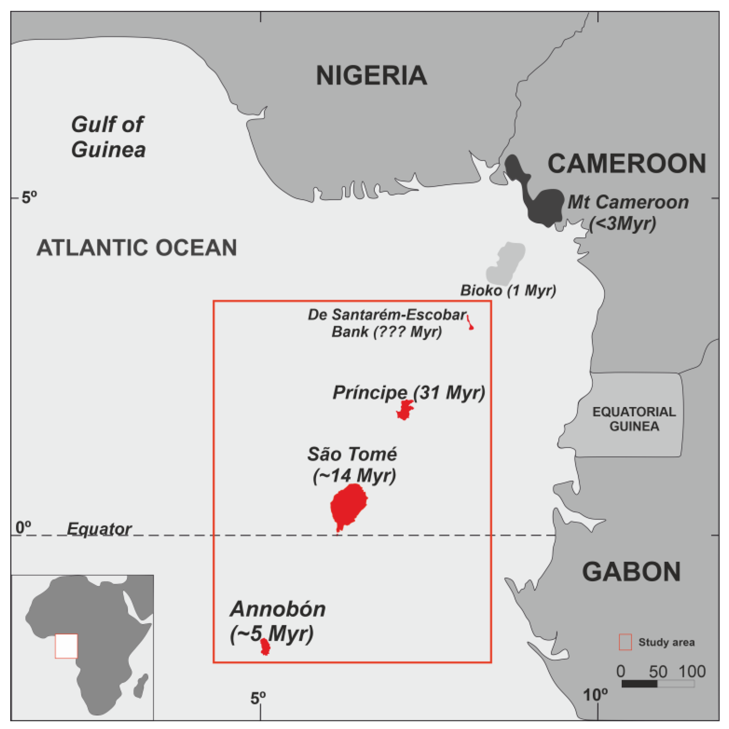
2. Geographical and Geological Setting

The study area is in the offshore region of West Africa, close to the equator, and refers to a linear N30°E alignment chain of islands—Annobón (also known as Pagalú), São Tomé, Príncipe, and Bioko (former Fernando Pó)—arching over the Gulf of Guinea to a curving arc of peaks in Cameroon that define the “Cameroon Volcanic Line” or CVL. The CVL is a zone of extension that formed in the continental lithosphere at 65 My because of changes in the stress field in the nearby elevated lithosphere [28]. It consists of an 1800 km long linear chain of genetically related series of active Cenozoic intraplate volcanoes and plutonic structures that dates from 66 My to the present [29]. The 900 km long Cenozoic volcanism of the Biu Plateau in Central Nigeria marks the northern terminus of the CVL’s continental portion [30,31] (Figure 1). The offshore section is composed of a set of volcanic islands including Annobón (Pagalú) and Bioko, which are part of the Republic of Equatorial Guinea, as well as the island nation of the Democratic Republic of São Tomé and Príncipe, the second smallest African country. These Atlantic islands were all discovered by the Portuguese in 1471, and none of them exhibited any evidence of prior human habitation [32]. Both states are part of the Community of Portuguese-Speaking Countries, a group of countries bound together by their historical connections, use of the same language, and commitment to democracy and sustainable development [33].
The CVL represents one of the twenty “African Alive Corridors” that offer specific reference points for reconstructing and telling the last 200 My of Africa’s autobiography—the “African Pole of Rotation”. For many authors, it is the only example on Earth of a “hot line” of active intraplate volcanoes that have simultaneously evolved in both the oceanic and continental domains and are connected to a single underlying source [32]. However, a recent work by Adams [29] (and references therein), presents a range of geophysical evidence that concludes that the CVL is inherently inconsistent with its formation by a mantle plume, and that the interaction between mantle convection and the region’s preexisting lithospheric structures—the exact role of which is still unknown—is likely to have influenced the CVL’s formation. The area is home to some of the richest biodiversity in Africa, making it the “Cameroon Hotspots”, one of the Gondwana Alive Corridors that can help chronicle the narrative of life on Earth [34]. However, its geodiversity is still mostly unexplored; thus, it must be found, evaluated, and employed as a tool for local communities’ sustainable development [27].
Much of the mainland of this region is wet tropical, with large river systems and estuaries of muddy substrata unsuitable for coral growth or reef development due to turbid conditions [35]. However, the offshore area comprises a set of islands and seamounts situated along the CVL where coral communities settled and developed in clearer waters than the turbid mainland coast, and it is included within the Ecoregion ER134—Gulf of Guinea to Sierra Leone [36].
The submerged geomorphological features surrounding the Annobón, São Tomé, and Príncipe Islands, and the De Santarém–Escobar seamount (or bank according to [37]) reveal shapes that enable each of them to be related to some of the three major kinds of coral reef morphology (fringing reefs, barrier reefs, and atolls) and to explain the origin and evolution of coral reefs according to Darwin’s subsidence hypothesis (Figure 2).
Príncipe, São Tomé, and Annobón and nearby seamounts are really oceanic in character and have never been connected with the mainland or with each other, unlike Bioko, a continental shelf island that was recently connected to the African mainland [32]. Príncipe, São Tomé, and Annobón have similar petrogenetic histories, with basements of basaltic flows capped by more evolved rocks, and have been active in the past 5 My [38]. The age of the earliest exposed volcanic rocks in the oceanic sector of the CVL decreases oceanward from Principe (31 My) to São Tomé (13 My) and to Annobón (5 My) Islands, which is consistent with the suggested motion of the African plate over this period of time [38,39].
The isostatic sinking of the ocean floor as it cools and moves away from a mid-ocean ridge is determined by the thermal structure of the lithosphere and the kind of convective instability beneath the plates. The study by Crosby and McKenzie [40] provides maps of residual topography to estimate the swell volume, buoyancy flux, and melt generation rate for major offshore plume swells of modern ocean floors. For the Cameroon swell, the authors estimated a volume of 3.7 × 10⁵ Km3, a steady-state buoyancy flux of ~1.5 Mg·s−1, and a melt generation rate of 0.3 m3·s−1. Cenozoic climate conditions, i.e., the last 65 My, changed globally from much warmer than the present time in the first 15 My (Eocene) to the cold poles that characterize the modern world [41]. For the first part of the Cenozoic, the temperatures of tropical surface water and deep ocean water fluctuated simultaneously [42]. Over this time, different episodes of variations in sea level and in the temperature of the surface waters of the sea have been recognized as occurring, which conditioned the installation and development of coral reefs that built up the present-day drowned reef structures.
According to Wright [42], tropical surface water temperatures increased from 22 to 24 °C at the beginning of the Cenozoic to 28 °C during the Early Eocene, similar to those in the equatorial parts of the present oceans. From Late Oligocene (ca 25 My) to Middle Miocene (ca 15 My) Mathew et al. [43] identified an interval of clear coral reef expansion in SE Asia, when global tropical surface waters rose to 26 °C with two sharp increases around 14 and 13 My [42]. The Plio-Pleistocene (2.5 My) corresponded to a sea-level fall, but Quaternary reefs recorded an important episode of proliferation because of the Holocene sea-level rise that occurred at the end of the Pleistocene ice age [44]. Raja et al. [11] argue that the Pleistocene is among the most recent reef-boom intervals to be found in the geological record.
Different geoheritage contents that are mainly of volcanic type [45] can be identified and characterized in several geosites scattered across each individual island and the seamount, with its heritage value thus being significantly increased [46], as well as the corresponding potential use from a sustainable development perspective [47] (and references therein). However, the abiotic evolution recorded in the offshore areas of Annobón, São Tomé, and Príncipe Islands and De Santarém–Escobar seamount can also be interpreted through the analysis of their topographic relief and nearshore bathymetry, which enables each of them to be assigned to the subsidence hypothesis that Darwin uses to explain the origin of fringing reefs, barrier reefs, and atolls. By corresponding to a very illustrative record of geological processes that mark significant turning points in the development of the geological sciences, these sunken coral reef structures, understood as a whole, fulfill the criteria for intangible geoheritage previously established for other geological phenomena, which distinguishes them and is essential to the development of geological thinking [20].

3. Materials and Methods

Similar to icebergs, just a tiny portion of a coral reef’s structure is visible above the sea [6]. Analyzing ancient coral reefs that are above sea level and are currently sinking is even more difficult. However, data collected from satellite sensors and data from analogous fossil coral deposits (e.g., [48]) can help to overcome such constraints.
The present work was based on the interpretation of the current topographic relief of the offshore areas of Annobón, São Tomé, and Príncipe Islands, and the De Santarém–Escobar seamount. Bathymetric data were processed using several sources (Table 1). It integrated data from old hydrographic maps from the former Portuguese Ministry of the Navy and Overseas [49,50] and updated gridded bathymetry data provided by the British Oceanographic Data Center through the GEBCO Compilation Group [51]. The bathymetric data, when crossed with images from Google Earth, enable reef crests to be identified around the islands that make up the CVL (see Figure 2).
Finding material evidence to support the origin and evolution of coral reefs at the CVL according to Darwin’s subsidence hypothesis required fieldwork campaigns in São Tomé and Príncipe Islands to identify onshore limestone outcrops and collect samples for petrographic studies. Historical fossil collections sampled during the mid-20th century and stored at the Science Museum of the University of Coimbra (Portugal) were also checked. The reconstruction of the evolution of the ancient reefs from Annobón, São Tomé, Príncipe, and Bioko Islands, and De Santarém–Escobar seamount also integrated all available data regarding eustatic sea-level changes, bottom sea paleotemperatures, and eruption ages assigned to each one, according to the reference literature.

4. Building a Reef Necklace around Darwin’s Theory

Charles Darwin is traditionally related to the Galapagos Islands and to its extraordinary biodiversity. The geodiversity and geoheritage of these emblematic islands, considered as a “cathedral of the natural sciences”, were recently made known through a geotouristic guide intended for a broad readership [52]. However, Darwin’s contribution to Earth science’s development can be applied and extended to other geological contexts beyond the Galapagos and the Pacific Ocean. It can inspire other geotouristic and geoeducation initiatives in other territories of the planet, namely in Africa, a geological paradise for its geodiversity and richness of natural resources [53,54].
The Gulf of Guinea islands have previously been compared to “pearls along a necklace” making up the oceanic part of the CVL [32]. The Bioko, Príncipe, São Tomé, and Annobón Islands, and the nearby seamounts have similar volcanic peaks and are home to a variety of basalt flows, cones, dykes, plugs, and crater lakes, but they differ significantly in age and other characteristics, including the ancient coral reef morphology surrounding each of them that is currently submerged under the Atlantic waters.
These sunken volcanic islands’ offshore areas and seamounts are capped by former shallow-water carbonate platforms and reefs that developed during the mid-Neogene reef boom [11]. Local inhabitants empirically recognize the shallower parts of these ancient reefs and seamounts and they head to them for the traditional practice of artisanal fishing.
The volcanic history of these islands and seamounts can be related with the origin and evolution of the drowned carbonate platforms and coral reef structures they reveal under present sea levels (Figure 3 and Figure 4). While Annobón (the younger island) is surrounded by a very narrow platform with very steep slopes, Príncipe (the older island) displays a wide barrier reef built during the Oligocene and Miocene, when the climate was favorable to coral reef development [55].

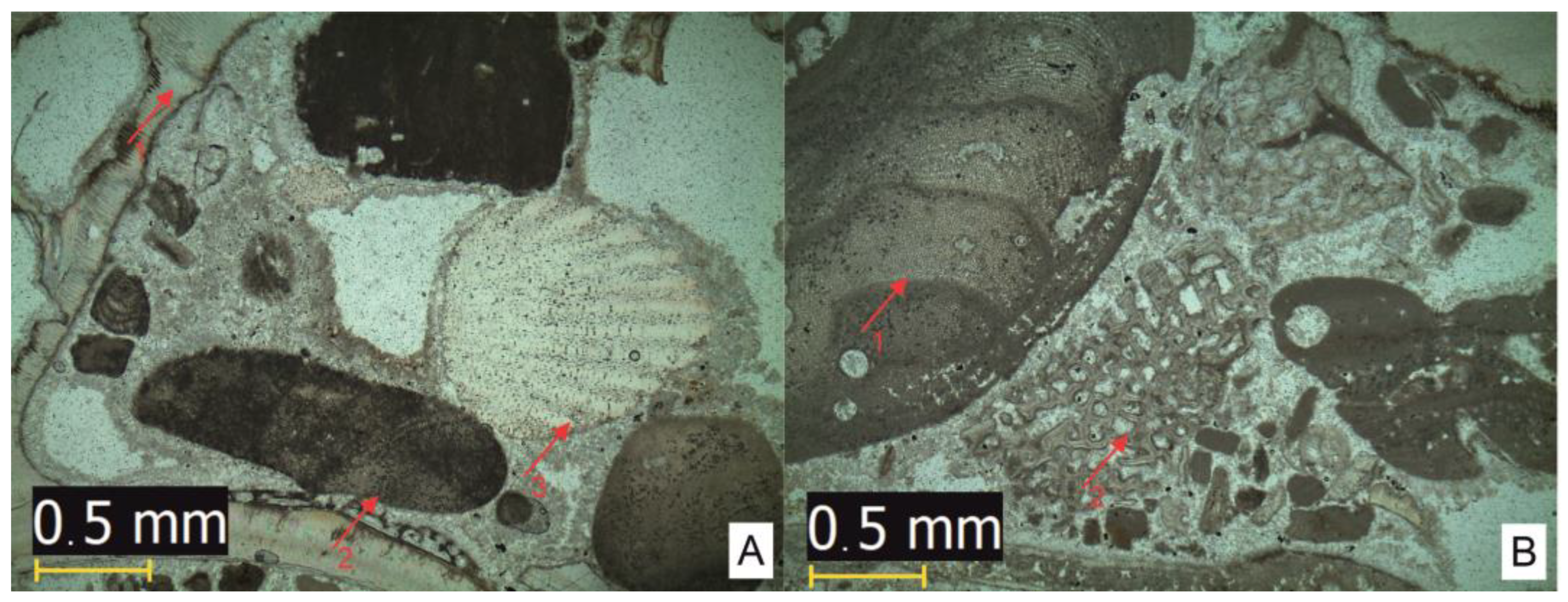
4.1. Fringing Coral Reefs: Annobón and São Tomé Islands

Annobón is a small island located 350 km from the Gabon coast at latitude 1°25′60″ S and longitude 5°37′60″ E with 236.27 km2 of area, and it was designated as a Réserve Naturelle at National level in 2000 [59]. It is formed of palagonitic breccia covered by basaltic flows, which are in turn overlain by alkaline lavas, mostly emplaced between 5.4 and 2.6 My ago [60]. Its highest point, Pico Quioveo, is 598 m above sea level. It is located at the south of Lake a Pot, the central crater of the ancient volcano that originated the island some 5 My ago. The island’s offshore area is bordered by a narrow carbonate platform with very steep slopes, representing the earlier stage of a fringing coral reef in a subsiding volcanic island.
São Tomé is an island with an area of 857 km2, situated 2 km (1¼ miles) north of the equator between latitudes 0°24′39.78″ N; 6°43′2.38″ E and 0°0′46.37″ S; 6°30′58.79″ E (the island of Rolas is crossed by the equator line). At Pico de São Tomé, it rises from a depth of roughly 3000 m to an altitude of 2024 m. Established in 2006, the Obô National Park aims to protect the significant biodiversity of the area since São Tomé and Príncipe is among the world’s most endemism-rich nations [61,62]. The National Park covers nearly 30% of the two islands’ total area: including the Obô Natural Park in São Tomé Island and the Obô Natural Park in Príncipe Island. Primarily made up of volcanic rocks, in São Tomé, four main volcano-stratigraphic units can be recognized: the São Tomé Volcanic Complex (<1.5 My); the Phonolitic Basaltic Complexes, which include the Ribeira Afonso Volcanic Complex (2.5–5 My) and the Mizambú Volcanic Complex (7–8 My); and the Ilhéu das Cabras Volcanic Formation (13 My) [63,64]. The two NE-SW trachytic hills that make up the Ilhéu das Cabras (coordinates 0°24′26.90 N; 6°42′52.61 E) are in line with the CVL, and it is one of the geosites included within the inventory and qualitative assessment of the geological heritage of São Tomé [17,18]. The island has a large submarine platform of approximately 450 km2, bounded by the 200 m isobath, representing the subsequent development stage of a fringing coral reef in a subsiding volcanic island. The reef carbonate framework that consists of calcareous crusts (i.e., crustose coralline algae) and scleractinian corals is essential to the existence of coral reef ecosystems [65]. A limestone outcrop recently identified on the NE coast of the island, about 5.5 km north of Guadalupe at Lobata Municipality (0°24′23.10″ N 6°36′36.53″ E), provides evidence of an ancient platform with abundant crustose coralline red algae, which would have acted as coral reef binders and consolidators [66,67]. The fining upward sequence lays on volcanic rock and is about 2 m thick. It comprises three irregular bounded beds: C1 is a conglomerate with volcanic and limestone clasts at the base, mixed with sandstone and bioclasts (Figure 5A,B); C2 is a fossiliferous limestone, showing diverse fossil assemblage (Figure 6A,B); and C3 is a compact limestone with planar lamination topped with a floatstone crust (Figure 7A,B).

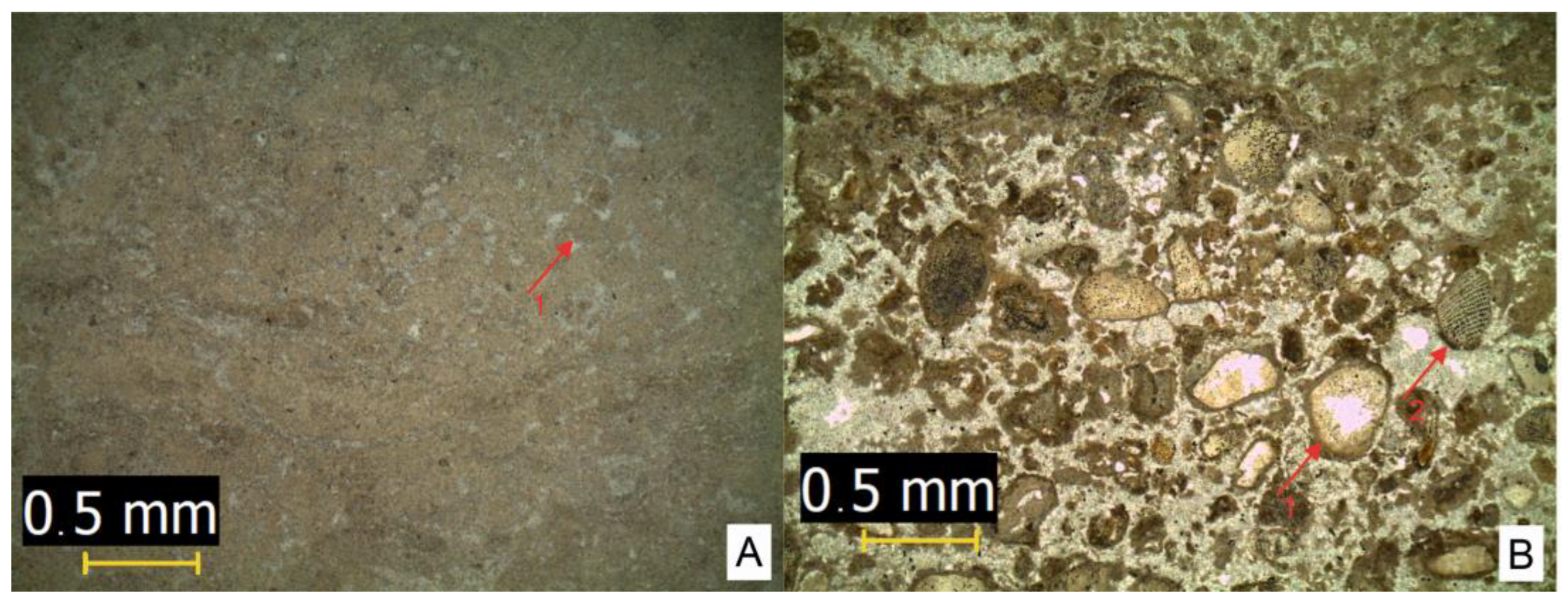
4.2. Barrier Coral Reef: Príncipe Island

Príncipe Island is located at latitude 1°37′12″ N and longitude 7°23′24″ E and occupies 136 km2 of immersed area. It rises from about a 3000 m depth to the altitude of 948 m at Pico do Príncipe in the south. It is essentially composed of lava flows of a basaltic nature, but there are also older phonolitic rocks, as well as trachytic, tephrite, and andesite, constituting domes and chimneys [68]. The oldest volcanic rocks outcropping on the island are 31 My in age (the basal palagonite breccia; 30.6 ± 2.1 My [69]), which corresponds to the establishment of a new plate-wide shallow-mantle convection pattern as the African plate began to settle [28]. It is overlain by the Older Lava Series basalt (23.6 ± 0.7 My) and hawaiite (19.1 ± 0.5 My), by the Younger Lava Series nephelinite (5.60 ± 0.32 My) and basanite (3.51 ± 0.15 My), and by intrusive phonolite (5.32 ± 0.17 My, 5.48 ± 0.19 My), tristanite (4.89 ± 0.15 My), and trachyphonolite (6.93 ± 0.68 My) plugs [69].
The island is surrounded by a large 100 m depth offshore platform with more than twice the area of the emerged territory with special importance for the reproduction of sea turtles, seabirds, and cetaceans, as well as coral reefs, and it was designated as a Biosphere Reserve in 2012 [70]. This extensive platform represents the former reef lagoon bordered by the ring-shaped reef crest resulting in the vertical growth of coral and corresponding to the barrier reef stage. It was recently subject to a detailed mapping of marine habitats using Side-Scan Sonar by De Esteban et al. [71] who identified a large rhodolith seascape at Baía das Agulhas, in the southwestern area of the island. Silva [72] previously referred to the occurrence of a small outcrop of bioclastic limestone located about 1.3 km SE of Santo António, which provided a diversified shallow marine benthic assemblage comprising corals, coralline algae, echinoderms, bivalves, and gastropods, of the Miocene age.

4.3. The De Santarém–Escobar Seamount
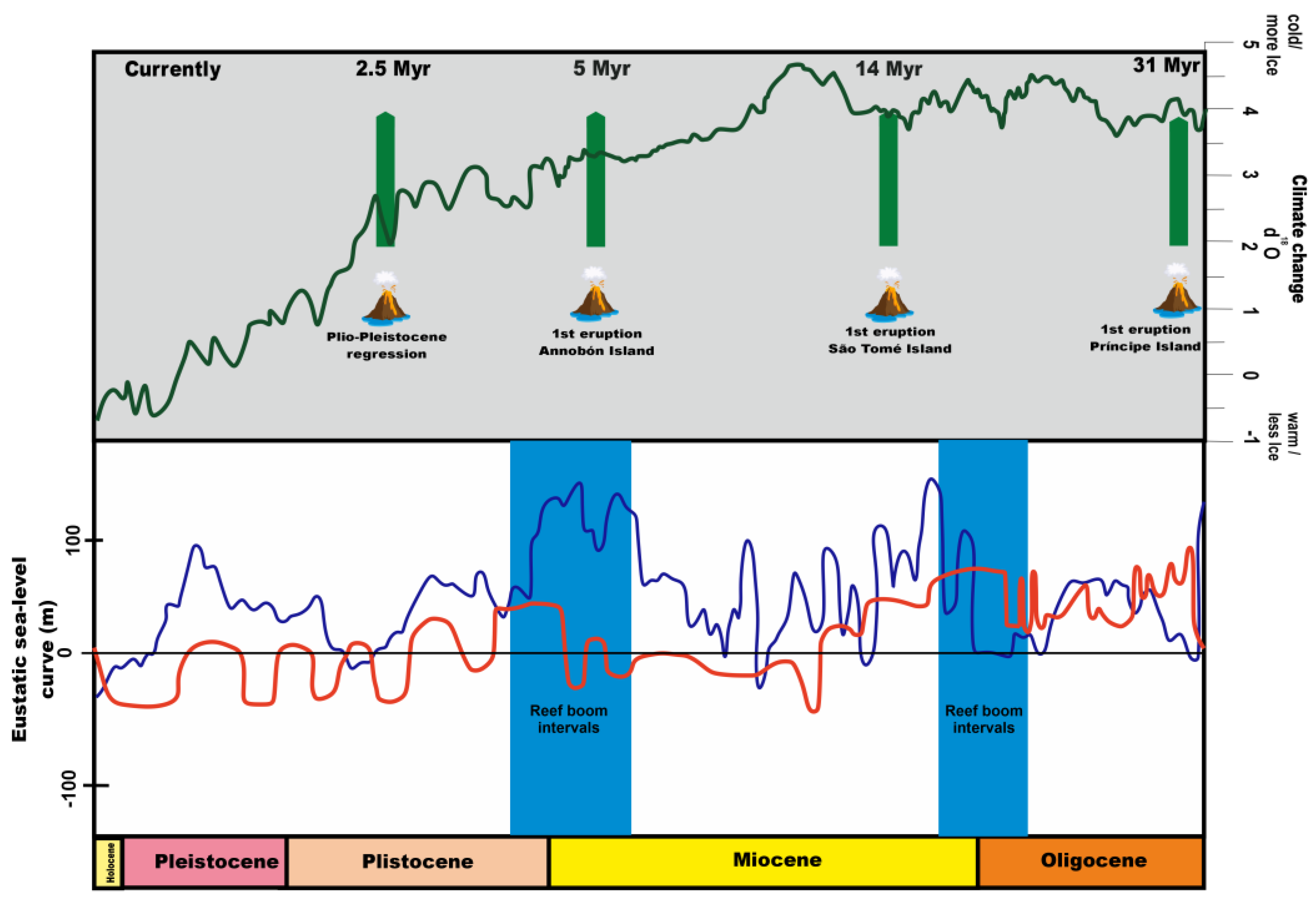
Part of the Equatorial Guinean Exclusive Economic Zone, the De Santarém–Escobar bank was named after the two Portuguese mariners who discovered Principe and São Tomé in 1471, João de Santarém and Pedro Escobar. It comprises a NW-SE elongated volcanic seamount located between Príncipe and Bioko Islands (latitude 2°47′52.2″ N and longitude 8°14′0.8″ E). It rises from about 1500 m to a large platform at around a 70 m depth through a high peak that emerges at up to a 2 m depth. Its small area (1.6 km2) does not fit the guyot definition proposed by Harris et al. [15] for seamounts having a flat top >10 km2 in areal extent and with a gradient of <20, but its shape features a typical submerged flat-topped seamount or bank.
There are no data regarding its age, but considering Darwin’s hypothesis, it is plausible to consider this submerged flattened structure as resulting from the subsidence of the oldest volcanic island of the Gulf of Guinea. Its genesis could be associated with the extensive restructuring of the mid-ocean ridge hydrothermal system that started in the Late Paleocene and continued into the Eocene [39]. In fact, during the Paleogene, the Central Atlantic recorded a broader and deeper equatorial gateway and a subsiding CVL [73] that would have enabled the further settlement and development of coral reefs, subsequent to the extended tropical cooling from 52 to 34 My [39]. Once built above sea level, over time, the former island and adjacent coral reef were subject to erosion by waves that flattened the top of the mount, and then it sank into deep waters. However, before we can have a deeper understanding of this past, we must drill and core this submerged structure.

5. Discussion

Geoheritage elements and sites are being subjected to geoconservation research as specific entities displaying three levels of meaning—physical, conceptual, and linguistic [74]. Inventorying and assessment methods of geoconservation can be implemented at scales ranging from international to local [75], but the numerical assessment of sites becomes difficult to manage when the same physical entity displays different heritage contents at different scales.
An evaluation system for geological heritage of a qualitative nature and that is scale-independent provides much wider applicability, being adaptable to different geological and socio-political contexts. The integrated approach proposed by Pena dos Reis and Henriques [43] is founded on the idea of geoheritage content, which is determined by the public’s comprehension of the meanings attached to geological objects (abstract perceptiveness) and the relevance of the meanings given to them by scientific communities (relevance grade).
Geoconservation concepts and ideas have commonly been used in tangible geological objects and/or forms corresponding to any expression of morphology or relations between units of Earth. However, geological processes, in themselves, are essentially immaterial and intangible. Geological elements and/or processes of international scientific relevance, used as milestones, and/or with a substantial contribution to the development of geological thinking through history, can also display geoheritage value, corresponding to intangible geoheritage, and fit into the body of knowledge that constitutes geoconservation [20].
Darwin was initially inspired by the geology of volcanic islands, and although he is best known for his theory of biological evolution, he also proposed a theory of atoll genesis from the subsidence of volcanic islands [76]. When the analysis scale is enlarged to the whole offshore area of the CVL (i.e., regional scale), the relation between the morphology of each island’s offshore area and seamount and the various stages of coral reef development is clear according to Darwin’s subsidence hypothesis. The set of volcano-capped swells from the CVL result from long, essentially immaterial, geological processes whose interpretation established a new theory used as a reference, and/or with a substantial contribution to the development of geological thinking, therefore representing a milestone for the history of the geological sciences. In this sense, such singular past process of coral reef development according to Darwin’s subsidence hypothesis, inferred from and/or supported by geosites and/or materials, meet the definition of intangible geoheritage, which is associated with phenomena rather than physical objects [20]. Such phenomena are particularly attractive for both geoscientists and biologists, among others, which supports the idea that Earth system science unites the other sciences [77].
As in material geoheritage, different contents can also be recognized in intangible geoheritage. A lot of questions about mantle geochemistry, shallow-mantle circulation, mantle lithosphere interaction, plate motion, plume behavior, and structural and geochemical evolution across a continental margin can be answered by studying the volcano-capped swells from the CVL, which are an extremely uncommon but underappreciated field laboratory [28]. Research on such items requires deep knowledge about the volcanic history of each island [78], about the isostatic subsidence patterns of the ocean floor [54], about the structure of coral reefs [15], as well as about the central idea postulated by Darwin who considered that the atolls he encountered during his expedition were the result of the upward development of coral as the Pacific Ocean floor gradually sank. From this perspective, the set of volcano-capped swells of the Gulf of Guinea, as with many onshore landscapes, displays documental content, i.e., a highly demonstrative record that is especially important for comprehending the major geologic changes associated with an area [43,44].
As well as the documental content that each of the volcano-capped swells may display, the whole set of volcanic islands and banks along the CVL display other heritage contents, therefore increasing its global heritage value.
While the type specimens of a microfossil species can typically only be observed and studied microscopically, the sea bottom morphology is also dependent on the use of specific devices for it to be perceived and analyzed. When such underwater morphology displays peculiar shapes modeled by geological processes (i.e., demonstrates a direct correlation between basic geological processes and the things they produce), we can assign them indicial content. This is the case for the fringing coral reef morphology recognized in the bottom waters surrounding the Annobón and São Tomé Islands and the barrier coral reef of the Príncipe Island and the De Santarém–Escobar seamount. The unique graphic output of these local scale geoheritage contents makes them appear as emergent witnesses of reef dynamics.
Local-scale content in a highly socialized location that is mostly utilized by the public for purposes other than geological ones is referred to as symbolic content [46]. It can be recognized in sites, landscapes, and objects such as fossils, rocks, or minerals [79]. Local people empirically recognize the emplacement of the shallower parts of CVL ancient reefs and seamounts and currently use those spots for the traditional practice of artisanal fishing, therefore assigning symbolic content to this geoheritage.
The widest definition of geoconservation is the inventory, evaluation, and conservation of the Earth’s geoheritage, together with their valuation (i.e., the development and implementation of appropriate geotourism and geoeducation initiatives) and monitoring [74].
To disclose the geoheritage of the ancient CVL coral reefs and make it available for non-specialist audiences requires the creation of initiatives for efficient tourist and educational applications (e.g., field guidebooks, websites, trails, leaflets, and interpretative panels embedded into a storytelling perspective [23]) in order to fulfill the functions inherent to geoconservation: to promote Earth science education and the dissemination of Earth science knowledge among the public [44] and to use geoheritage as a driver of economic and social transformation [80]. Africa, which accounts for 20% of the Earth’s surface and has four billion years of history, and its geoheritage needs to be found, assessed, and used as a tool for local communities to develop sustainably [27]. Even more so because “local nature-based solutions have the potential to contribute to transformational change, even at the global level” [81] (p. 185).

6. Conclusions

This work characterizes the submerged geomorphological features surrounding a linear chain of islands and banks corresponding to four volcano-capped swells located in the Cameroon Volcanic Line or CVL (Gulf of Guinea, West Africa): the Annobón, São Tomé, and Príncipe Islands and the De Santarém–Escobar seamount.
Each of them was analyzed considering the age of their oldest rocks, the current topographic relief of their offshore platforms, the sea-level changes during the last 30 my, outcrop data, and Darwin’s subsidence hypothesis for the origin and development of different types of reefs (fringing reefs, barrier reef, and atolls).
Annobón is the youngest island (5 My), and it is surrounded by a narrow platform with very steep slopes representing the early stage of a fringing reef. The oldest rocks from São Tomé Island are Middle Miocene in age (13 My). The submerged platform of this island is wider than the one of the previous islands representing the late stage of a fringing coral reef. Príncipe is the oldest island of this chain (31 My), and it displays a wide drowned barrier reef that resembles a coral necklace probably built during the Middle Miocene climatic optimum. Finally, the De Santarém–Escobar Bank is a submerged flattened structure resulting from the subsidence of the oldest volcanic island, and is truly oceanic in nature in the Gulf of Guinea.
When analyzed at a regional scale (i.e., as a linear chain of volcanic islands within the offshore area of the CVL), the clear relation between the morphology of the submerged part of each island and the seamount (type of reef) and the various stages of coral reef development according to Darwin’s subsidence hypothesis (origin and development of coral reefs) meets the concept of intangible geoheritage. This attribute, of a non-material nature, refers to representations of geological processes that are unique and decisive in the construction of geological thinking, and it is usually highly evaluated by scientific communities. The offshore area of each island and seamount of the CVL display other local to regional geoheritage contents, so far only applied to material geoheritage (indicial, symbolic, and documental), therefore increasing its global geoheritage value and potential use for geoeducation and geotourism purposes.
To use the linear chain of volcanic islands within the offshore area of the CVL as an educational resource and/or a geotouristic product requires bridging specialized knowledge of Earth sciences to non-specialized audiences. To tell the geological history of the coral reefs’ origin and evolution according to Darwin’s theory, storytelling is the best path to support a virtual geo-itinerary along the submerged geomorphology of the CVL islands and seamounts. The discourse used in this work aims to raise the awareness and capacity of local authorities and people on the management, conservation, and sustainable exploitation of present-day reefs, and to stand up for the development of further initiatives using African geoheritage to promote education and the sustainable development of the West Atlantic islands.

Author Contributions

Both authors contributed equally to the published version of the manuscript. All authors have read and agreed to the published version of the manuscript.

Funding

This research was funded by Fundação para a Ciência e a Tecnologia, I.P. (Portugal), in the frame of the UI/BD/151297/2021 grant supported by the UIDB/00073/2020 (https://doi.org/10.54499/UIDB/00073/2020) and the UIDP/00073/2020 (https://doi.org/10.54499/UIDP/00073/2020) projects of the I & D unit Geosciences Center (CGEO).

Institutional Review Board Statement

Not applicable.

Informed Consent Statement

Not applicable.

Data Availability Statement

Data are contained within the article.

Acknowledgments

This study is a contribution for the Portuguese National Committee for the International Geosciences Program of UNESCO (IGCP). We are grateful to Gustavo Gonçalves Garcia for the helpful discussions about the interpretation of the thin-section photomicrographs of the Guadalupe limestone outcrop. We acknowledge the anonymous reviewers for their comments and suggestions to improve the manuscript.

Conflicts of Interest

The authors declare no conflict of interest.

References

  1. Stoddart, D.R. Darwin, Lyell, and the Geological Significance of Coral Reefs. Brit. J. Hist. Sci. 1975, 9, 199–218. [Google Scholar] [CrossRef]
  2. Davies, P.J. Antecedent Platforms. In Encyclopedia of Modern Coral Reefs: Structure, Form and Process; Hopley, D., Ed.; Springer: Dordrecht, The Netherlands, 2011; pp. 40–47. [Google Scholar]
  3. Darwin, C. On certain areas of elevation and subsidence in the Pacific and Indian Oceans, as deduced from the study of coral formations. Proc. Geol. Soc. Lond. 1837, 2, 552–554. [Google Scholar]
  4. Darwin, C. Journal and Remarks 1832. In Narrative of the Surveying Voyage of His Majesty’s Ships Adventure and Beagle between the Years 1826 and 1836, Describing Their Examination of the Southern shores of South America, and the Beagle’s Circumnavigation of the Globe; Fitzroy, R.N., Ed.; Henry Colburn: London, UK, 1838; Volume III. [Google Scholar]
  5. Darwin, C.R. The Structure and Distribution of Coral Reefs. Being the First Part of the Geology of the Voyage of the Beagle, Under the Command of Capt. Fitzroy, R.N. During the Years of 1832 to 1836; Smith Elder and Co.: London, UK, 1842. [Google Scholar]
  6. Rosen, B. Darwin, Coral Reefs, and Global Geology. BioScience 1982, 32, 519–525. [Google Scholar] [CrossRef]
  7. Daly, R. The glacial-control theory of coral reefs. Proc. Am. Acad. Arts Sci. 1915, 51, 155–251. [Google Scholar] [CrossRef]
  8. Grigg, R.W.; Grossman, E.E.; Earle, S.A.; Gittings, S.R.; Lott, D.; McDonough, J. Drowned reefs and antecedent karst topography, Au’au Channel, S.E. Hawaiian Islands. Coral Reefs 2002, 21, 73–82. [Google Scholar] [CrossRef]
  9. Davis, W.M. Coral Reefs and Submarine Banks. J. Geol. 1918, XXVI, 385–411. [Google Scholar] [CrossRef]
  10. Droxler, A.W.; Jorry, S.J. The Origin of Modern Atolls: Challenging Darwin’s Deeply Ingrained Theory. Annu. Rev. Mar. Sci. 2021, 13, 537–573. [Google Scholar] [CrossRef]
  11. Raja, N.B.; Pandolfi, J.M.; Kiessling, W. Modularity explains large-scale reef booms in Earth’s history. Facies 2023, 69, 15. [Google Scholar] [CrossRef]
  12. Laborel, J. West African Reef Corals: A Hypothesis on Their Origin. In Proceedings of the Second International Coral Reef Symposium; Cameron, A.M., Great Barrier Reef Committee, Eds.; Great Barrier Reef Committee: Brisbane, Australia, 1974; Volume 1, pp. 425–443. [Google Scholar]
  13. Morais, R.A.; Maia, H.A. Lush underwater forests in mesophotic reefs of the Gulf of Guinea. Coral Reefs 2017, 36, 95. [Google Scholar] [CrossRef]
  14. Berrit, G.R. Les Eaux Dessalées du Golfe de Guinée; Centre De Recherches Oceanographiques: Abidjan, Côte d’Ivoire, 1966; Available online: https://horizon.documentation.ird.fr/exl-doc/pleins_textes/divers15-02/04436.pdf (accessed on 24 October 2023).
  15. Harris, P.T.; Macmillan-Lawler, M.; Ruppc, J.; Baker, E.K. Geomorphology of the oceans. Mar. Geol. 2014, 352, 4–24. [Google Scholar] [CrossRef]
  16. Schlager, W. The paradox of drowned reefs and carbonate platforms. GSA Bull. 1981, 92, 197–211. [Google Scholar] [CrossRef]
  17. Henriques, M.H.; Neto, K. Geoheritage at the Equator: Selected Geosites of São Tomé Island (Cameron Line, Central Africa). Sustainability 2015, 7, 648–667. [Google Scholar] [CrossRef]
  18. Henriques, M.H.; Neto, K. Revisiting Selected Geosites of São Tomé Island (Cameron Line, Central Africa). In Prime Archives in Sustainability, 1st ed.; Henriques, M.H., Ed.; Vide Leaf: Hyderabad, India, 2019; pp. 1–31. [Google Scholar] [CrossRef]
  19. Neto, K.; Henriques, M.H. Geoheritage of the Príncipe UNESCO World Biosphere Reserve (West Africa): Selected Geosites. Geoheritage 2023, 15, 118. [Google Scholar] [CrossRef]
  20. Henriques, M.H. Broadening Frontiers in Geoconservation: The Concept of Intangible Geoheritage Represented by the 1755 Lisbon Earthquake. Geoheritage 2023, 15, 57. [Google Scholar] [CrossRef]
  21. United Nations. About Small Island Developing States. Available online: https://www.un.org/ohrlls/content/about-small-island-developing-states (accessed on 20 November 2023).
  22. Pralong, J. Geotourism: A new form of tourism utilising natural landscapes and based on imagination and emotion. Tour. Rev. 2006, 61, 20–25. [Google Scholar] [CrossRef]
  23. Henriques, M.H.; Pena dos Reis, R. Storytelling the Geoheritage of Viana do Castelo (NW Portugal). Geoheritage 2021, 13, 46. [Google Scholar] [CrossRef]
  24. Lowery, B.; Dagevos, J.; Chuenpagdee, R.; Vodden, K. Storytelling for sustainable development in rural communities: An alternative approach. Sustain. Dev. 2020, 28, 1813–1826. [Google Scholar] [CrossRef]
  25. Ruban, D.A. Ancient carbonate reefs as geological heritage: State of knowledge and case example. Carbonates Evaporites 2023, 38, 75. [Google Scholar] [CrossRef]
  26. Henriques, M.H.; Andrade, A.I.S.; Lopes, F.C. The Earth Sciences among the Community of Portuguese-Speaking countries and the future of Gondwana. Episodes 2013, 36, 255–262. [Google Scholar] [CrossRef]
  27. Neto, K.; Henriques, M.H. Geoconservation in Africa: State of the art and future challenges. Gondwana Res. 2022, 110, 107–113. [Google Scholar] [CrossRef]
  28. Burke, K. Origin of the Cameroon Line of volcano-capped swells. J. Geol. 2001, 109, 349–362. [Google Scholar] [CrossRef]
  29. Adams, A. Insights into the Source of Magmatic Hot-Lines: Forty Years of Geophysical Studies of the Cameroon Volcanic Line. Front. Earth Sci. 2022, 10, 838993. [Google Scholar] [CrossRef]
  30. Rankenburg, K.; Lassiter, J.C.; Brey, G. The Role of Continental Crust and Lithospheric Mantle in the Genesis of Cameroon Volcanic Line Lavas: Constraints from Isotopic Variations in Lavas and Megacrysts from the Biu and Jos Plateaux. J. Pet. 2005, 46, 169–190. [Google Scholar] [CrossRef]
  31. Tefogoum, G.Z.; Nkouathio, D.G.; Dongmo, A.K.; Dedzo, M.G. Typology of geotouristic assets along the south continental branch of the Cameroon volcanic line: Case of the mount Bambouto’s caldera. Intern. J. Geoh Parks 2019, 7, 111–128. [Google Scholar] [CrossRef]
  32. Toteu, S.F.; Anderson, J.M.; de Wit, M. “Africa Alive Corridors”: Forging a new future for the people of Africa by the people of Africa. J. Afr. Earth Sci. 2010, 58, 692–715. [Google Scholar] [CrossRef]
  33. CPLP. Processo Histórico. Comunidade dos Países de Língua Oficial Portuguesa. Available online: https://www.cplp.org/id-2752.aspx (accessed on 19 October 2023).
  34. De Wit, M.J.; Anderson, J.M. Gondwana Alive Corridors: Extending Gondwana Research to Incorporate Stemming the Sixth Extinction. Gondwana Res. 2003, 6, 369–408. [Google Scholar] [CrossRef]
  35. Kleypas, J.A. Coral reef development under naturally turbid conditions: Fringing reefs near Broad Sound, Australia. Coral Reefs 1996, 15, 153–167. [Google Scholar] [CrossRef]
  36. Veron, J.E.N.; Stafford-Smith, M.G.; Turak, E.; DeVantier, L.M. Corals of the World. 2016. Available online: http://www.coralsoftheworld.org/coral_geographic/interactive_map/results/ (accessed on 22 October 2023).
  37. Spalding, M.D.; Ravilious, C.; Green, E.P. World Atlas of Coral Reefs, 1st ed.; University of California Press: Berkeley, CA, USA, 2001. [Google Scholar]
  38. Lee, D.-C.; Halliday, A.N.; Fitton, J.G.; Poli, G. Isotopic variations with distance and time in the volcanic islands of the Cameroon line: Evidence for a mantle plume origin. Earth Planet Sc Lett. 1994, 123, 119–138. [Google Scholar] [CrossRef]
  39. Njonfang, E.; Nono, A.; Kamgang, P.; Ngak, V.; Tchoua, F.M. Cameroon Line alkaline magmatism (Central Africa): A reappraisal. Geol. Soc. Am. Spec. Paper 2011, 478, 173–191. [Google Scholar] [CrossRef]
  40. Crosby, A.G.; McKenzie, D. An analysis of young ocean depth, gravity and global residual topography. Geophys. J. Int. 2009, 178, 1198–1219. [Google Scholar] [CrossRef]
  41. Zachos, J.C.; Dickens, G.R.; Zeebe, R.E. An early Cenozoic perspective on greenhouse warming and carbon-cycle dynamics. Nature 2008, 451, 279–283. [Google Scholar] [CrossRef] [PubMed]
  42. Wright, J.D. Cenozoic Climate Change. In Encyclopedia of Paleoclimatology and Ancient Environments; Gornitz, V., Ed.; Springer: Dordrecht, The Netherlands, 2009; pp. 148–155. [Google Scholar] [CrossRef]
  43. Mathew, M.; Makhankova, A.; Menier, D.; Sautter, B.; Betzler, C.; Pierson, B. The emergence of Miocene reefs in South China Sea and its resilient adaptability under varying eustatic, climatic and oceanographic conditions. Sci. Rep. 2020, 10, 7141. [Google Scholar] [CrossRef] [PubMed]
  44. Glischler, E. Quaternary reef response to sea-level and environmental change in the western Atlantic. Sedimentology 2015, 62, 429–465. [Google Scholar] [CrossRef]
  45. Németh, K. Volcanic Geoheritage in the Light of Volcano Geology. In El Hierro Island Global Geopark. Geoheritage, Geoparks and Geotourism; Dóniz-Páez, J., Pérez, N.M., Eds.; Springer: Cham, Switzerland, 2022; pp. 1–24. [Google Scholar] [CrossRef]
  46. Pena dos Reis, R.; Henriques, M.H. Approaching an integrated qualification and evaluation system for geological heritage. Geoheritage 2009, 1, 1–10. [Google Scholar] [CrossRef]
  47. Henriques, M.H.; Pena dos Reis, R.; Garcia, G.G.; João, P.; Marques, R.M.; Custódio, S. Developing paleogeographic heritage concepts and ideas through the Upper Jurassic record of the Salgado and Consolação geosites (Lusitanian Basin, Portugal). Resour. Policy 2022, 76, 102594. [Google Scholar] [CrossRef]
  48. Grigg, R.W. Paleoceanography of coral reefs in the Hawaiian-Emperor Chain—Revisited. Coral Reefs 1997, 16, S33–S38. [Google Scholar] [CrossRef]
  49. M.M.U. Carta Hidrográfica da Ilha de S. Tomé. Ministério da Marinha e do Ultramar: Lisboa, Portugal. 1963. Available online: https://gpixel.org/q/m/sth/yndex.php#zoom=1.2222405&x=0.5751106&y=0.4618568 (accessed on 14 October 2023).
  50. M.M.U. Carta Hidrográfica da Ilha do Príncipe. Ministério da Marinha e do Ultramar: Lisboa, Portugal. Available online: https://gpixel.org/q/m/pch/yndex.php#zoom=1.887791&x=0.2370025&y=0.1588588 (accessed on 14 October 2023).
  51. GEBCO Compilation Group. Global Ocean & Land Terrain Models. GEBCO_2023 Grid. Available online: https://www.gebco.net/data_and_products/gridded_bathymetry_data/gebco_2023/ (accessed on 22 October 2023).
  52. Kelley, D.; Page, K.; Quiroga, D.; Salazar, R. The Geodiversity and Geoheritage of the Galapagos Islands: A Geotouristic Guide. In the Footsteps of Darwin: Geoheritage, Geotourism and Conservation in the Galapagos Islands; Kelley, D., Page, K., Quiroga, D., Salazar, R., Eds.; Springer: Cham, Switzerland, 2019; pp. 135–183. [Google Scholar]
  53. Martínez-Frías, J.; Mogessie, A. The need for a geoscience education roadmap for Africa. Episodes 2012, 35, 489–492. [Google Scholar] [CrossRef] [PubMed]
  54. Errami, E.; Schneider, G.; Ennih, N.; Randrianaly, H.N.; Bendaoud, A.; Noubhani, A.; Norman, N.; Allan, M.; Lopo Vasconcelos, L.C.; Al-Wosabi, M.; et al. Geoheritage and Geoparks in Africa and the Middle-East: Challenges and Perspectives. In From Geoheritage to Geoparks. Geoheritage. Geoparks and Geotourism; Errami, E., Brocx, M., Semeniuk, V., Eds.; Springer: Cham, Switzerland, 2015; pp. 3–23. [Google Scholar] [CrossRef]
  55. Corda, L.; Palmiotto, C. Rhodalgal–foramol facies in equatorial carbonates: Insights from Miocene tectonic islands of the central Atlantic. Palaeogeogr. Palaeoclimatol. Palaeoecol. 2015, 428, 21–30. [Google Scholar] [CrossRef]
  56. Haq, B.U.; Hardenbol, J.; Vail, P.R. Chronology of fluctuating sea levels since the Triassic (250 million years ago to present). Science 1987, 235, 1156–1167. [Google Scholar] [CrossRef]
  57. Miller, K.G.; Browning, J.V.; Schmelz, W.J.; Kopp, R.E.; Mountain, G.S.; Wright, J.D. Cenozoic sea-level and cryospheric evolution from deep-sea geochemical and continental margin records. Sci. Adv. 2020, 6, eaaz1346. [Google Scholar] [CrossRef]
  58. Gradstein, F.M.; Ogg, J.G.; Schmitz, M.; Ogg, G. Geologic Time Scale 2020, 1st ed.; Elsevier: Amsterdam, The Netherlands, 2020. [Google Scholar]
  59. DPOA. Annobón. Equatorial Guinea. Digital Observatory for Protected Areas (DOPA) Explorer. European Commission. Available online: https://dopa-explorer.jrc.ec.europa.eu/wdpa/20269 (accessed on 11 October 2023).
  60. Cornen, G.; Maury, R.C. Petrology of the volcanic island of Annobon, Gulf of Guinea. Mar. Geol. 1980, 36, 253–267. [Google Scholar] [CrossRef]
  61. Almeida, A.; Ribeiro, S.; Botelho, H. Parque Nacional Obô: Conhecimento e perceções acerca da sua importância em alunos de S. Tomé. AmbientalMENTEsustenTable 2017, 1, 223–232. [Google Scholar] [CrossRef]
  62. TSTP. Parques Naturais. Turismo de São Tomé e Príncipe. Available online: https://visitsaotomeprincipe.st/en/lugares/regiao-centro-de-sao-tome/parques-naturais (accessed on 18 October 2023).
  63. Caldeira, R.; Munhá, J.M. Petrology of ultramafic nodules from São Tomé Island, Cameroon Volcanic Line (oceanic sector). J. Afr. Earth Sci. 2002, 34, 231–246. [Google Scholar] [CrossRef]
  64. Caldeira, R.; Madeira, J.; Munhá, J.M.; Afonso, R.S.; Mata, J.; Tassinari, C.C.; Nascimento, E. Caracterização das principais unidades volcano-estratigráficas da ilha de São Tomé, Golfo da Guiné. Ciências Terra 2003, V, A15–A18. Available online: https://repositorio.lneg.pt/bitstream/10400.9/946/1/28627CD_A15.pdf (accessed on 25 October 2023).
  65. Roik, A.; Order, C.; Röthig, T.; Voolstra, C.R. Spatial and seasonal reef calcification in corals and calcareous crusts in the central Red Sea. Coral Reefs 2016, 35, 681–693. [Google Scholar] [CrossRef]
  66. Weiss, A. Crustose coralline algae increased framework and diversity on ancient coral reefs. PLoS ONE 2017, 12, e0181637. [Google Scholar] [CrossRef] [PubMed]
  67. Teichert, S.; Steinbauer, M.; Kiessling, W. A possible link between coral reef success, crustose coralline algae and the evolution of herbivory. Sci. Rep. 2020, 10, 17748. [Google Scholar] [CrossRef]
  68. Lopes, J.M.R. Geocronologia Ar-Ar e Geoquímica Isotópica de Rochas das Ilhas de Ano-Bom, São Tomé e Príncipe da Linha Vulcânica dos Camarões. Ph.D. Thesis, Universidade de São Paulo, São Paulo, Brazil, 2020. Available online: https://www.teses.usp.br/teses/disponiveis/44/44141/tde-19112020-094211/publico/Dissertacao_Jose_Manuel_Ramos_Lopes.pdf (accessed on 11 October 2023).
  69. Dunlop, H.M.; Fitton, J.G. A K-Ar and Sr-isotopic study of the volcanic rocks of the island of principe, West Africa—Evidence for mantle heterogeneity beneath the Gulf of Guinea. Contrib. Miner. Petr 1979, 7, 125–131. [Google Scholar] [CrossRef]
  70. UNESCO. Island of Principe Biosphere Reserve, Sao Tome and Principe. Available online: https://en.unesco.org/biosphere/africa/island-of-principe (accessed on 26 October 2023).
  71. De Esteban, M.C.; Haroun, R.; Tuya, F.; Abreu, A.D.; Otero-Ferrer, F. Mapping marine habitats in the Gulf of Guinea: A contribution to the future establishment of Marine Protected Areas in Principe Island. Reg. Stud. Mar. Sci. 2023, 57, 102742. [Google Scholar] [CrossRef]
  72. Silva, G.H. La Faune Miocène de l’Île du Prince. Memórias Notícias 1956, 42, 29–52. [Google Scholar]
  73. Pérez-Díaz, L.; Eagles, G. South Atlantic paleobathymetry since early Cretaceous. Sci. Rep. 2017, 7, 11819. [Google Scholar] [CrossRef]
  74. Henriques, M.H.; Pena dos Reis, R.; Brilha, J.; Mota, T. Geoconservation as an Emerging Geoscience. Geoheritage 2011, 3, 117–128. [Google Scholar] [CrossRef]
  75. Brilha, J. Inventories and Evaluation. In Geoheritage; Reynard, E., Brilha, J., Eds.; Elsevier: Chennai, India, 2016; pp. 67–86. [Google Scholar]
  76. Johnson, M.E.; Baarli, B.G.; Cachão, M.; Mayoralc, E.; Ramalho, R.S.; Santos, A.; da Silva, C.M. On the rise and fall of oceanic islands: Towards a global theory following the pioneering studies of Charles Darwin and James Dwight Dana. Earth Sci. Rev. 2018, 180, 17–36. [Google Scholar] [CrossRef]
  77. Frodeman, R. Geology and Knowledge Culture. In Bridges to Global Ethics. Geoethics at the Confluence of Humanities and Sciences; Di Capua, G., Oosterbeek, L., Eds.; Springer: Cham, Switzerland, 2023; pp. 41–53. [Google Scholar] [CrossRef]
  78. Fitton, J.G.; Dunlop, H.M. The Cameroon Line, West-Africa, and Its Bearing on the Origin of Oceanic and Continental Alkali Basalt. Earth Planet. Sci. Lett. 1985, 72, 23–38. [Google Scholar] [CrossRef]
  79. Henriques, M.H.; Pena dos Reis, R. Framing the Palaeontological Heritage within the Geological Heritage: An Integrative Vision. Geoheritage 2015, 7, 249–259. [Google Scholar] [CrossRef]
  80. Carvalho, I.S.; Raminelli, R.; Henriques, M.H.P.; Soares, R.C.; Andrade, J.A.F.G.; Freitas, F.I. The Araripe Geopark (NE Brazil): Discovering the Earth’s Past as a Driver of Economic and Social Transformation. Geoheritage 2021, 13, 60. [Google Scholar] [CrossRef]
  81. UNDP. Human Development Report the Next Frontier. Human Development and the Anthropocene. UNDP: New York, USA. Available online: http://hdr.undp.org/sites/default/files/hdr2020.pdf#page=357 (accessed on 28 October 2023).
Figure 1. Geographical location of Annobón, São Tomé, Príncipe, and Bioko Islands, and De Santarém–Escobar seamount.
Sustainability 15 16863 g001
Figure 2. Bathymetric chart of bottom surface between Annobón, São Tomé, Príncipe, and Bioko Islands, and De Santarém–Escobar seamount. Reef crests are highlighted in yellow.
Sustainability 15 16863 g002
Figure 3. Reconstruction of the evolution of the ancient reefs from Annobón, São Tomé, Príncipe, and Bioko Islands, and De Santarém–Escobar seamount.
Sustainability 15 16863 g003
Figure 4. The earlier eruptions of Annobón, São Tomé, Príncipe, and Bioko Islands, and De Santarém–Escobar seamount, and sea-level changes. The eustatic sea-level curve is based on Haq et al. [56] shown in the red line, modified by Miller et al. [57] shown in the blue line; the reef boom is based on Gradstein et al. [58] and Raja et al. [11]; the bottom sea paleotemperatures curve is based on Zachos et al. [38] shown in the green line.
Sustainability 15 16863 g004
Figure 5. Thin-section photomicrographs of bed C1 from the limestone outcrop at Guadalupe. (A) Grainstone with bivalve mollusk (1), coralline algae (2), and equinoid (3) magnified 4×. (B) Grainstone with coralline algae (1), and coral (2) (magnified 4×).
Sustainability 15 16863 g005
Figure 6. Thin-section photomicrographs of bed C2 from the limestone outcrop at Guadalupe: (A) Grainstone with coralline algae (1), coral (2), and equinoid (3) magnified 4×. (B) Grainstone with: bivalve mollusk (1), coralline algae (2), and miliolid foraminifera (3) (magnified 4×).
Sustainability 15 16863 g006
Figure 7. Thin-section photomicrographs of bed C3 from the limestone outcrop at Guadalupe: (A) Mudstone with peloids (1) magnified 4×. (B) Floatstone with bivalve mollusk (1), and coralline algae (2) (magnified 4×).
Sustainability 15 16863 g007
Table 1. Sources of bathymetric data from the offshore areas of Annobón, São Tomé, and Príncipe Islands, and from De Santarém–Escobar seamount.
OrganizationReferenceAccess
GEBCO Compilation Group (2023)The GEBCO_2023 Grid [51]https://www.gebco.net/data_and_products/gridded_bathymetry_data/gebco_2023/ (accessed on 11 December 2023)
Ministério da Marinha e do Ultramar (1965)Carta Hidrográfica da Ilha do Príncipe [50]https://gpixel.org/q/m/pch/yndex.php#zoom=1.887791&x=0.2370025&y=0.1588588 (accessed on 11 December 2023)
Ministério da Marinha e do Ultramar (1963–1964)Carta Hidrográfica da Ilha de S. Tomé [49]https://gpixel.org/q/m/sth/yndex.php#zoom=1.2222405&x=0.5751106&y=0.4618568 (accessed on 11 December 2023)
Disclaimer/Publisher’s Note: The statements, opinions and data contained in all publications are solely those of the individual author(s) and contributor(s) and not of MDPI and/or the editor(s). MDPI and/or the editor(s) disclaim responsibility for any injury to people or property resulting from any ideas, methods, instructions or products referred to in the content.

